SPECIAL PROJECT PROGRESS REPORT
|
|
|
- Miranda Turner
- 6 years ago
- Views:
Transcription
1 SPECIAL PROJECT PROGRESS REPORT Progress Reports should be 2 to 10 pages in length, depending on importance of the project. All the following mandatory information needs to be provided. Reporting year 2017 Project Title: Computer Project Account: Principal Investigator(s): Affiliation: Name of ECMWF scientist(s) collaborating to the project (if applicable) Attributing predictable signals at subseasonal timescales to tropical forcing and surface boundary conditions spgbnort Warwick Norton, Dan Rowlands, Jason Beech-Brandt, Ann Shelly CFIC.. Start date of the project: 1 January 2015 Expected end date: 31 December 2017 Computer resources allocated/used for the current year and the previous one (if applicable) Please answer for all project resources Previous year Current year Allocated Used Allocated Used High Performance Computing Facility Data storage capacity (units) (Gbytes)
2 Summary of project objectives (10 lines max) Primary Project Objective Routine attribution of potentially predictable signals on subseasonal timescales (weeks 3-6). Secondary Project Objectives Establishing case studies that could be used for testing model improvements. Suggesting areas where model improvements might increase predictive skill. Summary of problems encountered We had some run failures that wasted resources and so requested an extra 500,000 SBU (which was granted) to complete our runs for the 2015/16 winter. The late arrival of ERA-interim in MARS means we have only just finished the runs for the 2016/17 winter. Ideally we would obtain the results much closer to real time (hopefully this will be available with ERA5). Summary of results of the current year We performed 3 sets of experiments over the 2015/16 (23 weekly start dates from to ) and 2016/17 (16 weekly start dates from to ) winters with 51 member ensembles: 1. T255L60 control initialised from ERA-interim with observed SSTs. 2. As in 1 except fields between 15N-15S are relaxed to ERA-interim fields. 3. As in 2 except initial conditions are sampled over the previous 20 years. For each set of experiments we also ran an 11 member hindcast over 20 years ( ) for each start date. These are two very contrasting winters, 2015/16 had very strong El Nino conditions, while 2016/17 was weak La Nina and generally had weak mean atmospheric signals. For example the mean winter NAO in 2016/17 was closest to zero since A summary of the skill in the two winters is shown in Figure 1 as the anomaly correlation as a function of lead time for the NAO (Figure 1a&c) and PNA (Figure 1b&d). Also included on these figures (in red) is the anomaly correlation from the operational monthly (which has the same Monday start dates) and average skill estimated from the 20 year hindcasts (dashed). In 2015/16 the NAO skill (Figure 1a) of both the control and the operational monthly was close to average, the tropical relaxation experiments were more skilful but again close to the average of the tropical relaxation hindcast. As is normal in El Nino years, the skill of the PNA (Figure 1b) was above average for all models against their respective average. In contrast, in 2016/17 the skill of the NAO (Figure 1c) was very low for day 10+. By day 15 the anomaly correlation of the control was close to zero while apparently the skill of the operational monthly was negative in week 4. In the tropical relaxation experiments the skill remained positive but significantly lower than average. For the PNA both control and operational monthly had low skill (though the control somewhat higher skill than the monthly in week 4). The tropical relaxation experiments had average PNA skill. Figure 2 shows the weekly mean NAO (Figure 2a&b) and PNA (Figures 2c&d) indices for 2015/16 (grey) and the ensemble mean week 2 (blue), week 4 (red) and week 6 (black) forecasts for the control (Figures 2a&c) and tropical relaxation (Figure 2b&d) experiments. The skill in predicting the weekly variability in the NAO was low for weeks 4 & 6 in the control run (Figure 2a) though it did know about the overall positive
3 (a) Figure 1. Anomaly correlation as a function of lead time for the NAO (a&c) and PNA (b&d) for the winters 2015/16 (a&b) and 2016/17 (c&d). Operational monthly (red), control experiment (black), tropical relaxation experiment (blue), dashed line are average from the respective 20 year hindcasts. NAO signal (the anomaly correlation skill mainly came from the seasonal signal). In the tropical relaxation experiments (Figure 2b) some of the weekly variability of the NAO was captured at week 4 and 6, and positive NAO signal was stronger. Notable in the control and tropical relaxation experiments is the lack of skill at week 4 in capturing the ve NAO spike in early December and the +ve NAO spike in late January. For the PNA again the seasonal signal of +ve PNA is well captured in both models at week 4, with the tropical relaxation experiments capturing more of the weekly variability. Note in the tropical relaxation runs the poorly forecast -ve PNA spike in December and the +ve PNA spike in early January. These two events are the precursors to the ve and +ve NAO events in January. Examination of the weekly maps shows that the ve PNA event produced a very wavy pattern which resulted in a Scandinavian block in early January which then transitioned to ve NAO. The tendency for poor Euro- Atlantic forecast skill in ve PNA via underestimation of blocking over Europe has been discussed by Ferranti et al (2014). The +ve PNA event was under forecast by all the models (including the tropical relaxation model) and the associated low pressure over eastern Canada. This low pressure subsequently moved east to give the strong +ve NAO event in late January. Figure 3 shows the corresponding plots for 2016/17. Generally both the control and tropical relaxation experiments had no idea on the weekly variability of the NAO at weeks 4 and 6, particularly notable is the large forecast miss on the NAO in December where both models at week 4 and 6 were predicting ve NAO yet what realised was strongly positive. The relaxed model had the idea that the NAO would increase from early to late winter (which is a typical pattern in La Nina winters). The control model also had no idea about the PNA, the week 6 mean was slightly positive yet there were several large ve PNA events, consequently
4 (a) Figure /16 weekly mean NAO (a&b) and PNA (c&d) indices, observed (grey), ensemble mean forecast week 2 (blue), week 4 (red) and week 6 (black) for the control (a&c) and tropical relaxation (b&d) experiments. California had a record breaking wet winter! Particularly poorly forecast by the control was the ve PNA period in December. In contrast the tropical relaxation experiment fixed the PNA! Other diagnostics (e.g. of the RMM1 index) showed the control (and operational monthly) had particularly poor skill in predicting tropical variability in the 2016/17 winter. This is part of the reason why the control (and operational monthly) had poor skill in predicting the PNA. We will now give two examples of individual forecasts (out of many interesting examples we have) highlighting amazing subseasonal predictability (if you can get the tropics right) but also outstanding issues (in the case of December 2016). Figure 4 shows week 5 forecasts (500 hpa geopotential anomalies relative to respective hindcasts) initialised on 11 January 2016 (validation period 8-14 February 2016). Figure 4a shows the operational monthly and is very similar to the control (Figure 4b), both showing a typical El Nino pattern across North America and the Atlantic (weak +ve NAO). What occurred is shown in Figure 4d, there is a very strong +PNA pattern across the US which resulted in very cold temperatures in the NE US (New York got close to record cold
5 (a) Figure /17 weekly mean NAO (a&b) and PNA (c&d) indices, observed (grey), ensemble mean forecast week 2 (blue), week 4 (red) and week 6 (black) for the control (a&c) and tropical relaxation (b&d) experiments. temperatures at -18C). Across Europe there is a very deep low pressure near the UK. Figure 4c shows the tropical relaxation experiment can reproduce all the features of the observed anomalies (though with slightly reduced amplitude). In fact our experiments with mixed up extra-tropical initial conditions (not shown) are very similar to Figure 4d indicating all the observed anomalies are driven from the tropics. Figure 5 shows week 4 forecasts initialised on 21 November 2016 (validation period December 2016). This is the poorly forecast period in December 2016 commented on previously. Both the monthly and control (Figures 5a&b) show ve NAO across the Atlantic (and cold for Europe). In fact what happened was a very deep low pressure across northern Canada and a ridge in the North Sea (which was moderately mild for Europe). The relaxed run (Figure 5c) had some elements of the pattern across the US but it had the pattern too far west across Europe. In the following week (19-26 December) the observed pattern transitioned to very strong +ve NAO by moving the low over Canada east. This evolution was not captured by any of the


")
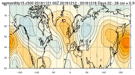
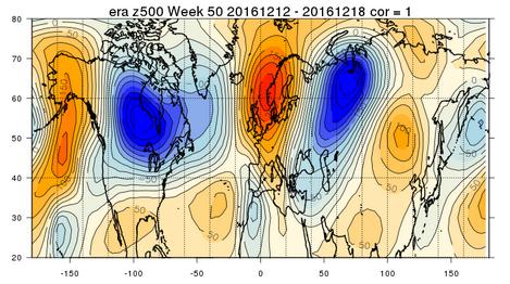
6 (a) Figure 4. Ensemble mean 500 hpa geopotential anomalies from week 5 forecasts initialised on 11 January 2016, (a) operational monthly, control experiment, tropical relaxation experiment, ERA-interim with validation period 8-14 February (a) Figure 5. Ensemble mean 500 hpa geopotential anomalies from week 5 forecasts initialised on 21 November 2016, (a) operational monthly, control experiment, tropical relaxation experiment, ERA-interim with validation period December 2016.

 control experiment, tropical relaxation experiment with ensemble mean (blue) and ERA-interim (black).")
7 models initialised on 21 November Figure 6 shows plume plots of NAO evolution (ERA-interim is black) from the control and relaxed runs. These plots show the overall ve NAO bias of the models and that the observed NAO evolution was outside the ensemble range (the relaxed run did slightly better in weeks 49 and 50 having more ensemble members transiting to +ve NAO). (a) Figure 6. Ensemble forecasts of the NAO from 21 November 2016, (a) control experiment, tropical relaxation experiment with ensemble mean (blue) and ERA-interim (black). These results raise the question of why the model skill in predicting the NAO in 2016/17 was so poor even with the correct tropics and variability of the PNA? There are possibly a number of contributing factors here. First it should be pointed that much of the regime behaviour in the 2016/17 winter did not directly project onto the NAO, e.g. Figure 5d is more a Scandinavian block rather than +ve NAO, Figure 5c is an Atlantic ridge pattern. As commented previously, the skill in predicting the major modes of variability in the tropics was very low in the 2016/17 winter. There was no MJO activity from early November to mid-february but there was significant Kelvin wave activity (which is much less predictable). The lack of MJO activity could have been associated with the strong westerly phase of the QBO (Yoo and Sun, 2016) or possibly the strong ve Indian Ocean dipole. However the base states of the models (under weak La Nina SSTs) are also relevant. Figure 7 shows the mean winter 500 hpa height anomalies from the operational monthly at week 3&4 (Figure 7a), the control experiment at week 3&4 (Figure 7b), the relaxed experiment at week 5&6 (Figure 7c), and from ERAinterim (Figure 7d). It is apparent that both the operational monthly and the relaxed experiment underestimated the ve PNA base state though this is somewhat worse in the operational monthly suggesting
 week 3&4 from operational monthly forecast, week 3&4 from control experiment, week 5&6 from tropical relaxation experiment, ERA-interim.")


, the monthly forecasts significantly underestimate rainfall over the maritime continent and South America, and slightly over estimate rainfall over")
8 (a) Figure 7. Winter mean 500 hpa geopotential anomalies for 2016/17 (a) week 3&4 from operational monthly forecast, week 3&4 from control experiment, week 5&6 from tropical relaxation experiment, ERA-interim. that the coupled ocean has degraded the forecast. With the correct tropics the relaxed run in Figure 7c has obtained a good simulation of the PNA over the Pacific however over the eastern US, the PNA pattern has become too north-south while the analysis shows it to be more of a great circle route leading to more low pressure over eastern Canada (compare also with Figures 5c&d). So it could be the PNA teleconnection in the tropical relaxation model is either too weak or does not propagate correctly into the western Atlantic? It is interesting to compare the operational monthly tropical rainfall for January-March 2017 with measurements from GPM (Figure 8). Two features are evident (if you can believe GPM), the monthly forecasts significantly underestimate rainfall over the maritime continent and South America, and slightly over estimate rainfall over the central Pacific. Underestimating rainfall in the maritime continent west of 120E is particularly significant as 120E is approximately the dividing line to force ve PNA & +ve NAO compared to +ve PNA & -ve NAO (which tends to occur with convection east of 120E) based on studies of MJO teleconnections (e.g. Riddle 2012). The other notable feature of Figure 8 is how the maritime convection (and South American) rainfall drifts lower further into the forecast. We have analysed the SSTs around the maritime continent in the monthly forecast and they also trend slightly cooler with time and this might cause the drift of the rainfall. It should also be noted that ERA-interim underestimates maritime continent convection relative to the operational analysis so our tropical relaxation experiments could underestimate forcing from the tropics. An intriguing question is whether 2016/17 is similar to years in the 1950s-70s with poor seasonal mean NAO skill as discussed by Weisheimer et al (2017) and O Reilly et al (2017)? They identify these poor skill years to be associated with ve PNA when perhaps the SSTs don t have strong control over the tropical convection? We would like to address this question in an additional proposal for a 2-year special project.
9 Figure 8. January-March 2017 mean tropical (10N-10S) rainfall from GPM (black) and operational monthly forecast, week 1 (blue), week 2 (green), week 3 (orange), week 4 (cyan), week 5 (purple), week 6 (yellow). List of publications/reports/presentations from the project November 2016, Poster at ECMWF/ESA Workshop: Tropical modelling, observations and assimilation (Ann Shelly) December 2016, Oral presentation at S2S extremes workshop (Warwick Norton) December 2016, Oral presentation at AGU (Ann Shelly) January 2017, Oral presentation at AMS (Warwick Norton) February 2017, Seminar at ECMWF (Warwick Norton) Summary of plans for the continuation of the project Finish analysis of model runs particularly the mixed initial conditions experiments to establish whether the result for the 2015/16 winter that skill at week 4+ is the same whether or not extratropical initial conditions are used holds for the 2016/17 winter. Examine issues around how predictability of the PNA influences predictability of the NAO, for example understanding whether the state of the PNA influences the size of possible NAO errors. Examine if the control & relaxed models have a systematic error in the propagation of the PNA into the Atlantic sector. Preliminary results suggest the models have detectable drifts in the correlation structure of many fields, which then changes the teleconnections between different regions. Further analysis on whether the models have too weak tropical extra-tropical teleconnections. One intriguing result of initial analysis of the hindcast runs is that the PNA forecasts in the relaxed runs with corrected tropics appear to be under confident (like the NAO) whilst the control runs are not; to our knowledge this result has not been highlighted in the literature and suggests the control run PNA forecasts offset overconfident tropical convection forecasts with under confident teleconnections. Establishing the mechanism(s) giving rise to weak teleconnections will highlight ways to address these issues either in post-processing or improvement of model physics. For example, Figure 9 shows the 200 hpa zonal wind errors at week 4 from the operational monthly, control experiment, and tropical relaxation experiment hindcasts. All the models have a common error of not extending the Pacific jet far enough eastward. Rossby wave source (RWS) diagnostics (not shown) suggest this is the reason why RWS variability is too low across the central Pacific. Consider writing an ECMWF Technical Memo to give a full report of results along with suggestions
 Figure 9.")

 Flow-dependent verification of the ECMWF ensemble over the Euro-Atlantic sector, Q. J. R. Meteorol. Soc. DOI:10.1002/qj.2411. Riddle, E.")
, Atmospheric seasonal forecasts of the twentieth century: multi-decadal variability in predictive skill of the winter North Atlantic Oscillation (NAO) and")
10 for additional diagnostics that ECMWF should routinely produce in evaluating teleconnections for new model cycles. Also suggesting case studies that could be used for testing model improvements. (a) Figure 9. Winter mean 200 hpa zonal winds (a) week 4 from operational monthly hindcasts minus ERA-interim, week 4 from control experiment hindcasts minus ERA-interim, week 4 from tropical relaxation experiment hindcasts minus ERA-interim, ERA-interim. References O Reilly, C., et al (2017), Variability in seasonal forecast skill of Northern Hemisphere winters over the 20 th century, Geophys. Res. Letts, 44, Ferranti, L., et al (2014) Flow-dependent verification of the ECMWF ensemble over the Euro-Atlantic sector, Q. J. R. Meteorol. Soc. DOI: /qj Riddle, E., et al (2012) The impact of the MJO on clusters of wintertime circulation anomalies over the North American region, Clim Dyn DOI /s y Weisheimer, A., et al (2017), Atmospheric seasonal forecasts of the twentieth century: multi-decadal variability in predictive skill of the winter North Atlantic Oscillation (NAO) and their potential value for extreme event attribution, Q. J. R. Meteorol. Soc., 143, Yoo and Sun (2016), Modulation of the boreal wintertime Madden-Julian oscillation by the stratospheric quasi-biennial oscillation, Geophys. Res. Letts, 43,
ENSO Cycle: Recent Evolution, Current Status and Predictions. Update prepared by Climate Prediction Center / NCEP 5 August 2013
 ENSO Cycle: Recent Evolution, Current Status and Predictions Update prepared by Climate Prediction Center / NCEP 5 August 2013 Outline Overview Recent Evolution and Current Conditions Oceanic Niño Index
How far in advance can we forecast cold/heat spells?
 Sub-seasonal time scales: a user-oriented verification approach How far in advance can we forecast cold/heat spells? Laura Ferranti, L. Magnusson, F. Vitart, D. Richardson, M. Rodwell Danube, Feb 2012
SPECIAL PROJECT PROGRESS REPORT
 SPECIAL PROJECT PROGRESS REPORT Progress Reports should be 2 to 10 pages in length, depending on importance of the project. All the following mandatory information needs to be provided. Reporting year
ENSO Cycle: Recent Evolution, Current Status and Predictions. Update prepared by Climate Prediction Center / NCEP 15 July 2013
 ENSO Cycle: Recent Evolution, Current Status and Predictions Update prepared by Climate Prediction Center / NCEP 15 July 2013 Outline Overview Recent Evolution and Current Conditions Oceanic Niño Index
ENSO Cycle: Recent Evolution, Current Status and Predictions. Update prepared by Climate Prediction Center / NCEP 11 November 2013
 ENSO Cycle: Recent Evolution, Current Status and Predictions Update prepared by Climate Prediction Center / NCEP 11 November 2013 Outline Overview Recent Evolution and Current Conditions Oceanic Niño Index
The ECMWF Extended range forecasts
 The ECMWF Extended range forecasts Laura.Ferranti@ecmwf.int ECMWF, Reading, U.K. Slide 1 TC January 2014 Slide 1 The operational forecasting system l High resolution forecast: twice per day 16 km 91-level,
The Madden Julian Oscillation in the ECMWF monthly forecasting system
 The Madden Julian Oscillation in the ECMWF monthly forecasting system Frédéric Vitart ECMWF, Shinfield Park, Reading RG2 9AX, United Kingdom F.Vitart@ecmwf.int ABSTRACT A monthly forecasting system has
ENSO Cycle: Recent Evolution, Current Status and Predictions. Update prepared by Climate Prediction Center / NCEP 24 September 2012
 ENSO Cycle: Recent Evolution, Current Status and Predictions Update prepared by Climate Prediction Center / NCEP 24 September 2012 Outline Overview Recent Evolution and Current Conditions Oceanic Niño
Introduction of climate monitoring and analysis products for one-month forecast
 Introduction of climate monitoring and analysis products for one-month forecast TCC Training Seminar on One-month Forecast on 13 November 2018 10:30 11:00 1 Typical flow of making one-month forecast Observed
GPC Exeter forecast for winter Crown copyright Met Office
 GPC Exeter forecast for winter 2015-2016 Global Seasonal Forecast System version 5 (GloSea5) ensemble prediction system the source for Met Office monthly and seasonal forecasts uses a coupled model (atmosphere
ENSO Cycle: Recent Evolution, Current Status and Predictions. Update prepared by Climate Prediction Center / NCEP 25 February 2013
 ENSO Cycle: Recent Evolution, Current Status and Predictions Update prepared by Climate Prediction Center / NCEP 25 February 2013 Outline Overview Recent Evolution and Current Conditions Oceanic Niño Index
SPECIAL PROJECT PROGRESS REPORT
 SPECIAL PROJECT PROGRESS REPORT Progress Reports should be 2 to 10 pages in length, depending on importance of the project. All the following mandatory information needs to be provided. Reporting year
The North Atlantic Oscillation: Climatic Significance and Environmental Impact
 1 The North Atlantic Oscillation: Climatic Significance and Environmental Impact James W. Hurrell National Center for Atmospheric Research Climate and Global Dynamics Division, Climate Analysis Section
ENSO Cycle: Recent Evolution, Current Status and Predictions. Update prepared by Climate Prediction Center / NCEP 23 April 2012
 ENSO Cycle: Recent Evolution, Current Status and Predictions Update prepared by Climate Prediction Center / NCEP 23 April 2012 Outline Overview Recent Evolution and Current Conditions Oceanic Niño Index
KUALA LUMPUR MONSOON ACTIVITY CENT
 T KUALA LUMPUR MONSOON ACTIVITY CENT 2 ALAYSIAN METEOROLOGICAL http://www.met.gov.my DEPARTMENT MINISTRY OF SCIENCE. TECHNOLOGY AND INNOVATIO Introduction Atmospheric and oceanic conditions over the tropical
Connecting tropics and extra-tropics: interaction of physical and dynamical processes in atmospheric teleconnections
 Connecting tropics and extra-tropics: interaction of physical and dynamical processes in atmospheric teleconnections Franco Molteni, Tim Stockdale, Laura Ferranti European Centre for Medium-Range Weather
ENSO: Recent Evolution, Current Status and Predictions. Update prepared by: Climate Prediction Center / NCEP 30 October 2017
 ENSO: Recent Evolution, Current Status and Predictions Update prepared by: Climate Prediction Center / NCEP 30 October 2017 Outline Summary Recent Evolution and Current Conditions Oceanic Niño Index (ONI)
Challenges in forecasting the MJO
 Challenges in forecasting the MJO Augustin Vintzileos University of Maryland ESSIC/CICS-MD Jon Gottschalck NOAA/NCEP/CPC Outline Forecasting at the interface between weather and climate Multi-scale impacts
Introduction of products for Climate System Monitoring
 Introduction of products for Climate System Monitoring 1 Typical flow of making one month forecast Textbook P.66 Observed data Atmospheric and Oceanic conditions Analysis Numerical model Ensemble forecast
Sub-seasonal to seasonal forecast Verification. Frédéric Vitart and Laura Ferranti. European Centre for Medium-Range Weather Forecasts
 Sub-seasonal to seasonal forecast Verification Frédéric Vitart and Laura Ferranti European Centre for Medium-Range Weather Forecasts Slide 1 Verification Workshop Berlin 11 May 2017 INDEX 1. Context: S2S
Special blog on winter 2016/2017 retrospective can be found here -
 March 4, 2019 Special blog on winter 2016/2017 retrospective can be found here - http://www.aer.com/winter2017 Special blog on winter 2015/2016 retrospective can be found here - http://www.aer.com/winter2016
Predictability and prediction of the North Atlantic Oscillation
 Predictability and prediction of the North Atlantic Oscillation Hai Lin Meteorological Research Division, Environment Canada Acknowledgements: Gilbert Brunet, Jacques Derome ECMWF Seminar 2010 September
Lecture 8: Natural Climate Variability
 Lecture 8: Natural Climate Variability Extratropics: PNA, NAO, AM (aka. AO), SAM Tropics: MJO Coupled A-O Variability: ENSO Decadal Variability: PDO, AMO Unforced vs. Forced Variability We often distinguish
Evolution of ECMWF sub-seasonal forecast skill scores
 Quarterly Journalof the RoyalMeteorologicalSociety Q. J. R. Meteorol. Soc. 140: 1889 1899, July 2014 B DOI:10.1002/qj.2256 Evolution of ECMWF sub-seasonal forecast skill scores Frédéric Vitart* European
ENSO: Recent Evolution, Current Status and Predictions. Update prepared by: Climate Prediction Center / NCEP 9 November 2015
 ENSO: Recent Evolution, Current Status and Predictions Update prepared by: Climate Prediction Center / NCEP 9 November 2015 Outline Summary Recent Evolution and Current Conditions Oceanic Niño Index (ONI)
The feature of atmospheric circulation in the extremely warm winter 2006/2007
 The feature of atmospheric circulation in the extremely warm winter 2006/2007 Hiroshi Hasegawa 1, Yayoi Harada 1, Hiroshi Nakamigawa 1, Atsushi Goto 1 1 Climate Prediction Division, Japan Meteorological
the 2 past three decades
 SUPPLEMENTARY INFORMATION DOI: 10.1038/NCLIMATE2840 Atlantic-induced 1 pan-tropical climate change over the 2 past three decades 3 4 5 6 7 8 9 10 POP simulation forced by the Atlantic-induced atmospheric
El Niño Update Impacts on Florida
 Current Issues in Emergency Management (CIEM) Sessions 1 &2 October 12 th and 26 th, 2006 Florida Division of Emergency Management Tallahassee, Florida El Niño Update Impacts on Florida Bart Hagemeyer
MJO prediction Intercomparison using the S2S Database Frédéric Vitart (ECMWF)
") MJO prediction Intercomparison using the S2S Database Frédéric Vitart (ECMWF) Slide 1 WGNE Meeting 29 April 2016 1 INDEX The S2S project and S2S Database MJO prediction in S2S models MJO teleconnections
MJO prediction Intercomparison using the S2S Database Frédéric Vitart (ECMWF) Slide 1 WGNE Meeting 29 April 2016 1 INDEX The S2S project and S2S Database MJO prediction in S2S models MJO teleconnections
TROPICAL-EXTRATROPICAL INTERACTIONS
 Notes of the tutorial lectures for the Natural Sciences part by Alice Grimm Fourth lecture TROPICAL-EXTRATROPICAL INTERACTIONS Anomalous tropical SST Anomalous convection Anomalous latent heat source Anomalous
Probabilistic predictions of monsoon rainfall with the ECMWF Monthly and Seasonal Forecast Systems
 Probabilistic predictions of monsoon rainfall with the ECMWF Monthly and Seasonal Forecast Systems Franco Molteni, Frederic Vitart, Tim Stockdale, Laura Ferranti, Magdalena Balmaseda European Centre for
Predictability of Sudden Stratospheric Warmings in sub-seasonal forecast models
 Predictability of Sudden Stratospheric Warmings in sub-seasonal forecast models Alexey Karpechko Finnish Meteorological Institute with contributions from A. Charlton-Perez, N. Tyrrell, M. Balmaseda, F.
Seasonal to decadal climate prediction: filling the gap between weather forecasts and climate projections
 Seasonal to decadal climate prediction: filling the gap between weather forecasts and climate projections Doug Smith Walter Orr Roberts memorial lecture, 9 th June 2015 Contents Motivation Practical issues
Vertical Moist Thermodynamic Structure of the MJO in AIRS Observations: An Update and A Comparison to ECMWF Interim Reanalysis
 Vertical Moist Thermodynamic Structure of the MJO in AIRS Observations: An Update and A Comparison to ECMWF Interim Reanalysis Baijun Tian 1 Duane Waliser 1, Eric Fetzer 1, and Yuk Yung 2 1.Jet Propulsion
Interpretation of Outputs from Numerical Prediction System
 Interpretation of Outputs from Numerical Prediction System Hiroshi OHNO Tokyo Climate Center (TCC)/ Climate Prediction Division of Japan Meteorological Agency (JMA) Procedure of Seasonal Forecast (1) 1.
Climate Forecast Applications Network (CFAN)
") Forecast of 2018 Atlantic Hurricane Activity April 5, 2018 Summary CFAN s inaugural April seasonal forecast for Atlantic tropical cyclone activity is based on systematic interactions among ENSO, stratospheric
Forecast of 2018 Atlantic Hurricane Activity April 5, 2018 Summary CFAN s inaugural April seasonal forecast for Atlantic tropical cyclone activity is based on systematic interactions among ENSO, stratospheric
2013 ATLANTIC HURRICANE SEASON OUTLOOK. June RMS Cat Response
 2013 ATLANTIC HURRICANE SEASON OUTLOOK June 2013 - RMS Cat Response Season Outlook At the start of the 2013 Atlantic hurricane season, which officially runs from June 1 to November 30, seasonal forecasts
Global climate predictions: forecast drift and bias adjustment issues
 www.bsc.es Ispra, 23 May 2017 Global climate predictions: forecast drift and bias adjustment issues Francisco J. Doblas-Reyes BSC Earth Sciences Department and ICREA Many of the ideas in this presentation
Challenges for Climate Science in the Arctic. Ralf Döscher Rossby Centre, SMHI, Sweden
 Challenges for Climate Science in the Arctic Ralf Döscher Rossby Centre, SMHI, Sweden The Arctic is changing 1) Why is Arctic sea ice disappearing so rapidly? 2) What are the local and remote consequences?
SPECIAL PROJECT FINAL REPORT
 SPECIAL PROJECT FINAL REPORT All the following mandatory information needs to be provided. Project Title: Sensitivity of decadal forecast to atmospheric resolution and physics Computer Project Account:
Climate Outlook and Review Focus on sugar industry requirements. Issued 1 October Roger C Stone
 Climate Outlook and Review Focus on sugar industry requirements Issued 1 October 2017 Roger C Stone University of Southern Queensland Document title 1 Overview A short La Nina-type pattern trying to develop
Diagnostics of the prediction and maintenance of Euro-Atlantic blocking
 Diagnostics of the prediction and maintenance of Euro-Atlantic blocking Mark Rodwell, Laura Ferranti, Linus Magnusson Workshop on Atmospheric Blocking 6-8 April 2016, University of Reading European Centre
Tropical drivers of the Antarctic atmosphere
 Tropical drivers of the Antarctic atmosphere Bradford S. Barrett Gina R. Henderson Oceanography Department U. S. Naval Academy Acknowledge support of: NSF awards ARC-1203843 and AGS-1240143 ONR award N1416WX01752
Monthly forecasting system
 424 Monthly forecasting system Frédéric Vitart Research Department SAC report October 23 Series: ECMWF Technical Memoranda A full list of ECMWF Publications can be found on our web site under: http://www.ecmwf.int/publications/
Charles Jones ICESS University of California, Santa Barbara CA Outline
 The Influence of Tropical Variations on Wintertime Precipitation in California: Pineapple express, Extreme rainfall Events and Long-range Statistical Forecasts Charles Jones ICESS University of California,
Global Climate Patterns and Their Impacts on North American Weather
 Global Climate Patterns and Their Impacts on North American Weather By Julie Malmberg and Jessica Lowrey, Western Water Assessment Introduction This article provides a broad overview of various climate
David W. Reynolds * National Weather Service WFO San Francisco Bay Area Monterey, CA
 3.2 THE MADDEN JULIAN OSCILLATION: ITS POTENTIAL FOR WEEK TWO FLOOD OUTLOOKS AND RESERVOIR MANAGEMENT DECISIONS IN CALIFORNIA David W. Reynolds * National Weather Service WFO San Francisco Bay Area Monterey,
What is the Madden-Julian Oscillation (MJO)?
?") What is the Madden-Julian Oscillation (MJO)? Planetary scale, 30 90 day oscillation in zonal wind, precipitation, surface pressure, humidity, etc., that propagates slowly eastward Wavelength = 12,000 20,000
What is the Madden-Julian Oscillation (MJO)? Planetary scale, 30 90 day oscillation in zonal wind, precipitation, surface pressure, humidity, etc., that propagates slowly eastward Wavelength = 12,000 20,000
Climate Outlook and Review
 Climate Outlook and Review September 2018 Author: Prof Roger C Stone Overview The European, UK, and US long-term climate models that focus on forecasting central Pacific sea surface temperatures are continuing
Interdecadal variability of the ENSO teleconnection to the wintertime North Pacific
 Climate Dynamics (2018) 51:3333 3350 https://doi.org/10.1007/s00382-018-4081-y Interdecadal variability of the ENSO teleconnection to the wintertime North Pacific Christopher H. O Reilly 1 Received: 3
Chapter outline. Reference 12/13/2016
 Chapter 2. observation CC EST 5103 Climate Change Science Rezaul Karim Environmental Science & Technology Jessore University of science & Technology Chapter outline Temperature in the instrumental record
THE INFLUENCE OF CLIMATE TELECONNECTIONS ON WINTER TEMPERATURES IN WESTERN NEW YORK INTRODUCTION
 Middle States Geographer, 2014, 47: 60-67 THE INFLUENCE OF CLIMATE TELECONNECTIONS ON WINTER TEMPERATURES IN WESTERN NEW YORK Frederick J. Bloom and Stephen J. Vermette Department of Geography and Planning
ENSO, AO, and climate in Japan. 15 November 2016 Yoshinori Oikawa, Tokyo Climate Center, Japan Meteorological Agency
 ENSO, AO, and climate in Japan 15 November 2016 Yoshinori Oikawa, Tokyo Climate Center, Japan Meteorological Agency Aims of this lecture At the end of the yesterday s lecture, Hare-run said, - In the exercise
Eurasian Snow Cover Variability and Links with Stratosphere-Troposphere Coupling and Their Potential Use in Seasonal to Decadal Climate Predictions
 US National Oceanic and Atmospheric Administration Climate Test Bed Joint Seminar Series NCEP, Camp Springs, Maryland, 22 June 2011 Eurasian Snow Cover Variability and Links with Stratosphere-Troposphere
Winter Forecast. Allan Huffman RaleighWx
 Winter 2015-16 Forecast Allan Huffman RaleighWx Disclaimer Seasonal forecasting is difficult and you are always learning. I attempt to look at all factors I understand and have seen correlate in the past
Impacts of Climate Change on Autumn North Atlantic Wave Climate
 Impacts of Climate Change on Autumn North Atlantic Wave Climate Will Perrie, Lanli Guo, Zhenxia Long, Bash Toulany Fisheries and Oceans Canada, Bedford Institute of Oceanography, Dartmouth, NS Abstract
Example of the one month forecast
 Example of the one month forecast Masayuki Hirai Tokyo Climate Center (TCC)/ Climate Prediction Division of Japan Meteorological Agency (JMA) Example Note that the initial time and the forecast target
Forecasting at the interface between weather and climate: beyond the RMM-index
 Forecasting at the interface between weather and climate: beyond the RMM-index Augustin Vintzileos University of Maryland ESSIC/CICS-MD Jon Gottschalck NOAA/NCEP/CPC Outline The Global Tropics Hazards
Sub-seasonal predictions at ECMWF and links with international programmes
 Sub-seasonal predictions at ECMWF and links with international programmes Frederic Vitart and Franco Molteni ECMWF, Reading, U.K. 1 Outline 30 years ago: the start of ensemble, extended-range predictions
Here s what a weak El Nino usually brings to the nation with temperatures:
 Time again for my annual Winter Weather Outlook. Here's just a small part of the items I considered this year and how I think they will play out with our winter of 2018-2019. El Nino / La Nina: When looking
Does the stratosphere provide predictability for month-ahead wind power in Europe?
 ICEM 2017 Bari 27 June 2017 Does the stratosphere provide predictability for month-ahead wind power in Europe? Remo Beerli, Heini Wernli and Christian Grams Remo.Beerli@env.ethz.ch Institute for Atmospheric
First-Order Draft Chapter 3 IPCC WG1 Fourth Assessment Report
 0 Figure... Estimates of linear trends in significant wave height (cm decade - ) for the regions along the major ship routes for the global ocean for the period 0 00. Trends are shown only for the locations
ENSO Outlook by JMA. Hiroyuki Sugimoto. El Niño Monitoring and Prediction Group Climate Prediction Division Japan Meteorological Agency
 ENSO Outlook by JMA Hiroyuki Sugimoto El Niño Monitoring and Prediction Group Climate Prediction Division Outline 1. ENSO impacts on the climate 2. Current Conditions 3. Prediction by JMA/MRI-CGCM 4. Summary
Climate Outlook for March August 2018
 The APEC CLIMATE CENTER Climate Outlook for March August 2018 BUSAN, 26 February 2018 The synthesis of the latest model forecasts for March to August 2018 (MAMJJA) from the APEC Climate Center (APCC),
Northeast River Forecast Center s
 Northeast River Forecast Center s Apr 13 th Spring Outlook Brought to you by: Edward Capone Service Coordination Hydrologist Overview to Include: Potential flood outlook convective/synoptic conditions
WINTER FORECAST NY Metro
 2015-2016 WINTER FORECAST NY Metro Weather @NY_WX DISCLAIMER: Seasonal forecasting is difficult and this is my first attempt at a Winter Forecast. I ve looked at all factors and put them together to create
Living with the butterfly effect: a seamless view of predictability
 from Newsletter Number 45 Autumn 25 VIEWPOINT Living with the butterfly effect: a seamless view of predictability Νicholashan/iStock/Thinkstock doi:957/x4h3e8w3 This article appeared in the Viewpoint section
Nonlinear atmospheric teleconnections
 GEOPHYSICAL RESEARCH LETTERS, VOL.???, XXXX, DOI:10.1029/, Nonlinear atmospheric teleconnections William W. Hsieh, 1 Aiming Wu, 1 and Amir Shabbar 2 Neural network models are used to reveal the nonlinear
Delayed Response of the Extratropical Northern Atmosphere to ENSO: A Revisit *
 Delayed Response of the Extratropical Northern Atmosphere to ENSO: A Revisit * Ruping Mo Pacific Storm Prediction Centre, Environment Canada, Vancouver, BC, Canada Corresponding author s address: Ruping
High initial time sensitivity of medium range forecasting observed for a stratospheric sudden warming
 GEOPHYSICAL RESEARCH LETTERS, VOL. 37,, doi:10.1029/2010gl044119, 2010 High initial time sensitivity of medium range forecasting observed for a stratospheric sudden warming Yuhji Kuroda 1 Received 27 May
Impacts of Recent El Niño Modoki on Extreme Climate Conditions In East Asia and the United States during Boreal Summer
 Impacts of Recent El Niño Modoki on Extreme Climate Conditions In East Asia and the United States during Boreal Summer Hengyi Weng 1, Karumuri Ashok 1, Swadhin Behera 1, Suryachandra A. Rao 1 and Toshio
Interactions Between the Stratosphere and Troposphere
 Interactions Between the Stratosphere and Troposphere A personal perspective Scott Osprey Courtesy of Verena Schenzinger The Wave-Driven Circulation Global structure of Temperature and Wind Temperature
Update of the JMA s One-month Ensemble Prediction System
 Update of the JMA s One-month Ensemble Prediction System Japan Meteorological Agency, Climate Prediction Division Atsushi Minami, Masayuki Hirai, Akihiko Shimpo, Yuhei Takaya, Kengo Miyaoka, Hitoshi Sato,
Oceanic origin of the interannual and interdecadal variability of the summertime western Pacific subtropical high
 Click Here for Full Article GEOPHYSICAL RESEARCH LETTERS, VOL. 35, L13701, doi:10.1029/2008gl034584, 2008 Oceanic origin of the interannual and interdecadal variability of the summertime western Pacific
The U. S. Winter Outlook
 The 2018-2019 U. S. Winter Outlook Michael Halpert Deputy Director Climate Prediction Center Mike.Halpert@noaa.gov http://www.cpc.ncep.noaa.gov Outline About the Seasonal Outlook Review of 2017-18 U. S.
Thai Meteorological Department, Ministry of Digital Economy and Society
 Thai Meteorological Department, Ministry of Digital Economy and Society Three-month Climate Outlook For November 2017 January 2018 Issued on 31 October 2017 -----------------------------------------------------------------------------------------------------------------------------
Special blog on winter 2016/2017 retrospective can be found here -
 February 11, 2019 Special blog on winter 2016/2017 retrospective can be found here - http://www.aer.com/winter2017 Special blog on winter 2015/2016 retrospective can be found here - http://www.aer.com/winter2016
University of Reading, Reading, United Kingdom. 2 Hadley Centre for Climate Prediction and Research, Meteorological Office, Exeter, United Kingdom.
 9.1 RUNNING A CLIMATE MODEL IN FORECAST MODE TO IDENTIFY THE SOURCE OF TROPICAL CLIMATE ERRORS: WITH SPECIFIC REFERENCE TO THE DRY BIAS OVER THE MARITIME CONTINENT IN AN ATMOSPHERE ONLY GCM 1 Jane Strachan,
The Coupled Model Predictability of the Western North Pacific Summer Monsoon with Different Leading Times
 ATMOSPHERIC AND OCEANIC SCIENCE LETTERS, 2012, VOL. 5, NO. 3, 219 224 The Coupled Model Predictability of the Western North Pacific Summer Monsoon with Different Leading Times LU Ri-Yu 1, LI Chao-Fan 1,
Seasonal Climate Watch January to May 2016
 Seasonal Climate Watch January to May 2016 Date: Dec 17, 2015 1. Advisory Most models are showing the continuation of a strong El-Niño episode towards the latesummer season with the expectation to start
EMC Probabilistic Forecast Verification for Sub-season Scales
 EMC Probabilistic Forecast Verification for Sub-season Scales Yuejian Zhu Environmental Modeling Center NCEP/NWS/NOAA Acknowledgement: Wei Li, Hong Guan and Eric Sinsky Present for the DTC Test Plan and
Changes in Southern Hemisphere rainfall, circulation and weather systems
 19th International Congress on Modelling and Simulation, Perth, Australia, 12 16 December 2011 http://mssanz.org.au/modsim2011 Changes in Southern Hemisphere rainfall, circulation and weather systems Frederiksen,
The Planetary Circulation System
 12 The Planetary Circulation System Learning Goals After studying this chapter, students should be able to: 1. describe and account for the global patterns of pressure, wind patterns and ocean currents
UPDATE OF REGIONAL WEATHER AND SMOKE HAZE (December 2017)
") UPDATE OF REGIONAL WEATHER AND SMOKE HAZE (December 2017) 1. Review of Regional Weather Conditions for November 2017 1.1 In November 2017, Southeast Asia experienced inter-monsoon conditions in the first
UPDATE OF REGIONAL WEATHER AND SMOKE HAZE (December 2017) 1. Review of Regional Weather Conditions for November 2017 1.1 In November 2017, Southeast Asia experienced inter-monsoon conditions in the first
Possible Roles of Atlantic Circulations on the Weakening Indian Monsoon Rainfall ENSO Relationship
 2376 JOURNAL OF CLIMATE Possible Roles of Atlantic Circulations on the Weakening Indian Monsoon Rainfall ENSO Relationship C.-P. CHANG, PATRICK HARR, AND JIANHUA JU Department of Meteorology, Naval Postgraduate
Monitoring and Prediction of Climate Extremes
 Monitoring and Prediction of Climate Extremes Stephen Baxter Meteorologist, Climate Prediction Center NOAA/NWS/NCEP Deicing and Stormwater Management Conference ACI-NA/A4A Arlington, VA May 19, 2017 What
ATMOSPHERIC MODELLING. GEOG/ENST 3331 Lecture 9 Ahrens: Chapter 13; A&B: Chapters 12 and 13
 ATMOSPHERIC MODELLING GEOG/ENST 3331 Lecture 9 Ahrens: Chapter 13; A&B: Chapters 12 and 13 Agenda for February 3 Assignment 3: Due on Friday Lecture Outline Numerical modelling Long-range forecasts Oscillations
NOTES AND CORRESPONDENCE. El Niño Southern Oscillation and North Atlantic Oscillation Control of Climate in Puerto Rico
 2713 NOTES AND CORRESPONDENCE El Niño Southern Oscillation and North Atlantic Oscillation Control of Climate in Puerto Rico BJÖRN A. MALMGREN Department of Earth Sciences, University of Göteborg, Goteborg,
California 120 Day Precipitation Outlook Issued Tom Dunklee Global Climate Center
 California 120 Day Precipitation Outlook Issued 11-01-2008 Tom Dunklee Global Climate Center This is my second updated outlook for precipitation patterns and amounts for the next 4 s of the current rainy
Winter. Here s what a weak La Nina usually brings to the nation with tempseraures:
 2017-2018 Winter Time again for my annual Winter Weather Outlook. Here's just a small part of the items I considered this year and how I think they will play out with our winter of 2017-2018. El Nino /
A stochastic method for improving seasonal predictions
 GEOPHYSICAL RESEARCH LETTERS, VOL. 39,, doi:10.1029/2012gl051406, 2012 A stochastic method for improving seasonal predictions L. Batté 1 and M. Déqué 1 Received 17 February 2012; revised 2 April 2012;
The pilot real-time sub-seasonal MME prediction in WMO LC-LRFMME
 The pilot real-time sub-seasonal MME prediction in WMO LC-LRFMME Suhee Park, Jin Ho Yoo, Soonjo Yoon and Miah Kim WMO LC-LRFMME May 2016 1. Introduction WMO and many operational centers realized the necessity
Developing Operational MME Forecasts for Subseasonal Timescales
 Developing Operational MME Forecasts for Subseasonal Timescales Dan C. Collins NOAA Climate Prediction Center (CPC) Acknowledgements: Stephen Baxter and Augustin Vintzileos (CPC and UMD) 1 Outline I. Operational
ENSO and ENSO teleconnection
 ENSO and ENSO teleconnection Hye-Mi Kim and Peter J. Webster School of Earth and Atmospheric Science, Georgia Institute of Technology, Atlanta, USA hyemi.kim@eas.gatech.edu Abstract: This seminar provides
REQUEST FOR A SPECIAL PROJECT
 REQUEST FOR A SPECIAL PROJECT 2011 2013 MEMBER STATE: ITALY... Principal Investigator 1 : Affiliation: Address: Dr. Fred Kucharski. Abdus Salam International Centre for Theoretical Physics (ICTP) Strada
ANNUAL CLIMATE REPORT 2016 SRI LANKA
 ANNUAL CLIMATE REPORT 2016 SRI LANKA Foundation for Environment, Climate and Technology C/o Mahaweli Authority of Sri Lanka, Digana Village, Rajawella, Kandy, KY 20180, Sri Lanka Citation Lokuhetti, R.,
NOAA 2015 Updated Atlantic Hurricane Season Outlook
 NOAA 2015 Updated Atlantic Hurricane Season Outlook Dr. Gerry Bell Lead Seasonal Forecaster Climate Prediction Center/ NOAA/ NWS Collaboration With National Hurricane Center/ NOAA/ NWS Hurricane Research
Climate Outlook for October 2017 March 2018
 The APEC CLIMATE CENTER Climate Outlook for October 2017 March 2018 BUSAN, 25 September 2017 The synthesis of the latest model forecasts for October 2017 to March 2018 (ONDJFM) from the APEC Climate Center
Global Dynamics of Climate Variability and Change
 MOSAC and SRG Meetings 2014 5 th -7 th November 2014 MOSAC PAPER 19.10 Global Dynamics of Climate Variability and Change Adam Scaife 1. Introduction On regional scales it is often the dynamics of regional
Toward Seamless Weather-Climate Prediction with a Global Cloud Resolving Model
 DISTRIBUTION STATEMENT A. Approved for public release; distribution is unlimited. Toward Seamless Weather-Climate Prediction with a Global Cloud Resolving Model PI: Tim Li IPRC/SOEST, University of Hawaii