The Impacts of GPSRO Data Assimilation and Four Ices Microphysics Scheme on Simulation of heavy rainfall Events over Taiwan during June 2012
|
|
|
- Nancy Watkins
- 5 years ago
- Views:
Transcription
1 The Impacts of GPSRO Data Assimilation and Four Ices Microphysics Scheme on Simulation of heavy rainfall Events over Taiwan during June 2012 Pay-Liam LIN, Y.-J. Chen, B.-Y. Lu, C.-K. WANG, C.-S. CHEN, Y.-L. CHEN C.-Y. Ke, T.-C. Chen Wang and Wei-Kuo TAO Department of Atmospheric Sciences National Central University
2 Outline Torrential Rainfall Occurred over Taiwan during 12 June 2012 Introduction Model Configuration Experiment Design Results & Discussion
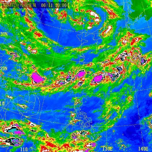
3 Mesoscale Convective System 3


4 Introduction Heavy rainfall occurred over northern Taiwan, central Taiwan and southwestern Taiwan on June 12, Picture from: /


5 East Asia Study Case 2012/6/ LST EC Analysis Mei-Yu Front L Taiwan Southwesterly Flow

 350mm/24hr (Extremely")
6 Yangmei Max:123 mm/hr For 10 hours, 30 mm/hr Total:479.5 mm /10hr CWB:15 mm/hr (Heavy Rain) 350mm/24hr (Extremely Torrential Rain) 6

")


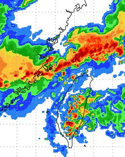
7 / UTC (2000LST) Con. Div. surface 850 mb 300 mb 7


8 Introduction- Analysis 2012/06/11 00Z 2012/06/11 06Z 2012/06/11 12Z Taiwan 2012/06/11 18Z 2012/06/12 00Z Mei-yu front near Taiwan SW wind prevails over Taiwan
")
9 JMA Analysis (850 hpa) 2012/6/12 00UTC Taiwan is over the wet Area (shading: T-Td<3 o C) Taiwan
10 JMA Analysis (300 hpa) 2012/6/12 00UTC the upper-level trough, which is favorable for the development of heavy rainfall Taiwan
11 Observation Summary This is a linear MCS along Mei-Yu front that bring more than 400mm of rain in the evening. Favorable environmental conditions for the the system east of short trough low-level convergence upper-level divergence It s difficult to forecast mesoscale systems evolution. 11
 BL:")
12 Model Configuration WRF V3.5.1 NCEP GFS MP: Goddard GCE scheme CU: Kain-Fritsch scheme (Domain 1 and 2) BL: YSU scheme SF: Unified Noah landsurface model 27/9/3 km
13 Experiment Design(1) COLD Without data assimilation CTRL Data assimilation(cycling) twice With GTS_GPS GTS_ONLY Cycling four times GTS_GPS Cycling four times GTS_ONLY GTS_GPS 06/10 12Z Goal: 1. Assimilate observational data to Improve rainfall prediction 2. Test GPS impact on rainfall distribution COLD CTRL 06/11 00Z 06/11 00Z 06Z 12Z Use WRF 3DVAR 18Z 06/11 00Z 06Z 12Z
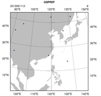
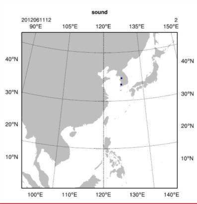
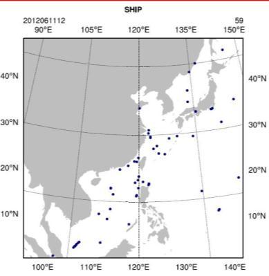
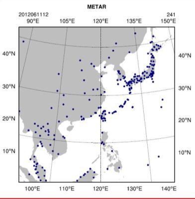
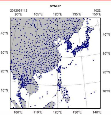
14 Data Assimilation- data location (06/11 12Z) SYNOP SHIP SATEM BUOY AIREP METAR PILOT GPSREF SOUND


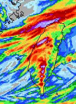
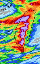
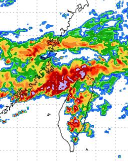
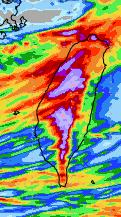
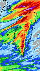
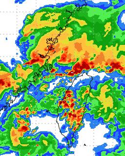
15 Results-radar reflectivities 2012/06/11 23Z LST COLD GTS_ONLY CTRL GTS_GPS
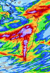
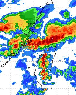
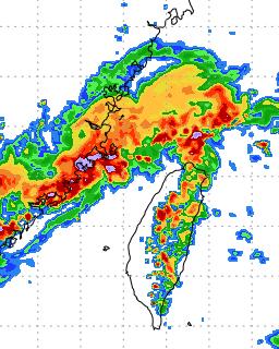
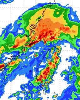
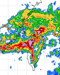
16 Accumulated precipitation COLD 06/ /13 00 LST CTRL GTS_GPS GTS_ONLY
17 Results- ETS score (ctl1112)ctrl (cold00)cold (fg1112)gts_gps (fo1112)gts_only
18 Experiment Design(2) CTRL Data assimilation(cycling) twice With GTS_GPS EC FNL GFS DA (GPS+GTS) Cycling four times Use WRF 3DVAR EC FNL GFS 1) 4ice 2) 3ice 1) 4ice 2) 3ice Goal: 1. Impact of DA Cycling Times 2. Test different boundary and initial condition (EC FNL GFS) 3.Test 4ice and 3ice scheme CTRL DA 06/10 12Z 18Z 06/11 00Z 06Z 12Z 06/11 00Z 06Z 12Z
.")
 is required for real")

19 Why do we need to have the 4-ICE scheme? Observation 3ICE-Hail 3ICE-Graupel Almost all microphysics schemes are 3-ICE (cloud ice, snow and graupel). Very few 3ICE schemes have the option to have hail processes (cloud ice, snow, graupel or hail) Both hail and/or graupel can occur in real weather events simultaneously, therefore a 4ICE scheme (cloud ice, snow, graupel and hail) is required for real time forecasts (especially for high-resolution prediction of severe local thunderstorms, midlatitude squall lines and tornadoes) Current and future global high-resolution cloud-resolving models need the ability to predict/simulate a variety of weather systems from weak to intense (i.e., tropical cyclones, thunderstorms) over the globe; this requires the use of a 4ICE scheme 19
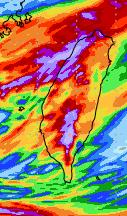
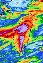
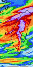
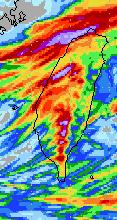
20 Results-accumulated precipitation (EC) 06/ /13 00 LST CTRL- 3ice DA-3ice CTRL- 4ice DA-4ice mm

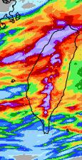
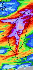
21 Results-max DBZ (EC) CTRL-3ice CTRL-4ice DB Z 2012/06/11 23Z LST DA- 3ice DA-4ice
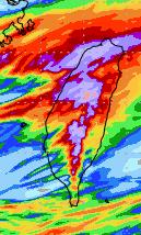
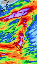
22 Results-accumulated precipitation (FNL) 06/ /13 00 LST CTRL-3ice DA-3ice CTRL-4ice DA-4ice mm
23 Results-max DBZ (FNL) CTRL-3ice CTRL-4ice DB Z 2012/06/11 23Z LST DA-3ice DA-4ice


24 Results-accumulated precipitation (GFS) 06/ /13 00 LST mm CTRL-3ice DA-3ice CTRL-4ice DA-4ice
")


25 Results-max DBZ (GFS) CTRL-3ice CTRL-4ice DB Z 012/06/11 23Z LST DA-3ice DA-4ice
 06/12 00 06/13 00 LST")

26 Discussion- I.C. B.C. Model starts from 06/11 00 UTC (08LST) 06/ /13 00 LST rainfall accumulation 3ice_3km_EC 3ice_3km_NCEP GFS Model initialized with EC reanalysis data show better rainfall simulation than the model results initialized with GFS forecast data.


27 Discussion- I.C. and B.C. Time: 2012/06/11 12 Z Field: RH Diff. (925hPa:left & 850hPa:right) EC - GFS FNL - GFS EC - GFS FNL - GFS
28 Simulation Domain and initial time setup


29 Experiment Design GCM: FNL 0.5 vs ERA interim 0.75 Domain: different size and location on d02 Time: 6/10 08:00 vs 6/11 08:00 LST
30 Accumulated Precipitation
31 Conclusion The frontal in the run with bigger domain on d02 can move faster than the run with smaller domain and land on time though the unideal frontal position makes an unideal precipitation pattern. Although the frontal in the run with earlier initial time lands late, the ideal structure of frontal can make an ideal pattern of precipitation.
32 Simulation Microphysical Scheme
33 Experiment Design Domain: 9km 3km Landuse update Microphysics 4Ice JP WSM5 WSM6 Radiation Cumulus PBL Land-surface Surface-layer RRTM & Goddard previous Kain-Fritsch YSU Noah Monin-Obukhov Reference from MEFSEA

34 Accumulated Precipitation


35 The experiment design for Mei-Yu case in Hybrid system: period1: 10 June Z ~ 11 June Z period2: 11 June Z ~ 12 June Z
36 Hybrid Day1 ( Z~ Z)


37 Hybrid Day2 ( Z~ Z)
38 Conclusion Initial conditions (ICs.) and boundary conditions (BCs.) are important for the model prediction. For 12 June 2012 case, EC reanalysis data are better ICs. and BCs. than GFS data resulting in better rainfall prediction. To improve the model run with GFS data as ICs. and BCs., data assimilation (WRF 3DVAR) has applied. With four cycles run, rainfall over northern Taiwan and southwestern Taiwan has improved as compared to COLD START run and CTRL run. Increasing DA times improves precipitation time lag in all simulations and precipitation pattern. With GPS data assimilation could be more realistic to simulate heavy rainfall. IC and BC input will result in different precipitation pattern and value over Taiwan, especially over northern Taiwan.
COSMIC GPS Radio Occultation and
 An Impact Study of FORMOSAT-3/ COSMIC GPS Radio Occultation and Dropsonde Data on WRF Simulations 27 Mei-yu season Fang-Ching g Chien Department of Earth Sciences Chien National and Taiwan Kuo (29), Normal
Impact of FORMOSAT 3/COSMIC Radio Occultation. near Taiwan
 Impact of FORMOSAT 3/COSMIC Radio Occultation Data on Predictions i of Typhoon and Mei yu Fronts near Taiwan CHING YUANG HUANG 1,2, CHAN SENG WONG 1, CHIEN JU WANG 2, and CHIN CHENG TSAI 2 1 Department
Shu-Ya Chen 1, Tae-Kwon Wee 1, Ying-Hwa Kuo 1,2, and David H. Bromwich 3. University Corporation for Atmospheric Research, Boulder, Colorado 2
 IMPACT OF GPS RADIO OCCULTATION DATA ON ANALYSIS AND PREDICTION OF AN INTENSE SYNOPTIC-SCALE STORM OVER THE SOUTHERN OCEAN NEAR THE ANTARCTIC PENINSULA Shu-Ya Chen 1, Tae-Kwon Wee 1, Ying-Hwa Kuo 1,2,
Preliminary results. Leonardo Calvetti, Rafael Toshio, Flávio Deppe and Cesar Beneti. Technological Institute SIMEPAR, Curitiba, Paraná, Brazil
 HIGH RESOLUTION WRF SIMULATIONS FOR WIND GUST EVENTS Preliminary results Leonardo Calvetti, Rafael Toshio, Flávio Deppe and Cesar Beneti Technological Institute SIMEPAR, Curitiba, Paraná, Brazil 3 rd WMO/WWRP
ABSTRACT 3 RADIAL VELOCITY ASSIMILATION IN BJRUC 3.1 ASSIMILATION STRATEGY OF RADIAL
 REAL-TIME RADAR RADIAL VELOCITY ASSIMILATION EXPERIMENTS IN A PRE-OPERATIONAL FRAMEWORK IN NORTH CHINA Min Chen 1 Ming-xuan Chen 1 Shui-yong Fan 1 Hong-li Wang 2 Jenny Sun 2 1 Institute of Urban Meteorology,
Impact of GPS RO Data on the Prediction of Tropical Cyclones
 Impact of GPS RO Data on the Prediction of Tropical Cyclones Ying-Hwa Kuo, Hui Liu, UCAR Ching-Yuang Huang, Shu-Ya Chen, NCU Ling-Feng Hsiao, Ming-En Shieh, Yu-Chun Chen, TTFRI Outline Tropical cyclone
IMPACT OF ASSIMILATING COSMIC FORECASTS OF SYNOPTIC-SCALE CYCLONES OVER WEST ANTARCTICA
 IMPACT OF ASSIMILATING COSMIC REFRACTIVITY PROFILES ON POLAR WRF FORECASTS OF SYNOPTIC-SCALE CYCLONES OVER WEST ANTARCTICA David H. Bromwich 1, 2 and Francis O. Otieno 1 1 Polar Meteorology Group, Byrd
Incorporation of 3D Shortwave Radiative Effects within the Weather Research and Forecasting Model
 Incorporation of 3D Shortwave Radiative Effects within the Weather Research and Forecasting Model W. O Hirok and P. Ricchiazzi Institute for Computational Earth System Science University of California
Sensitivity of precipitation forecasts to cumulus parameterizations in Catalonia (NE Spain)
") Sensitivity of precipitation forecasts to cumulus parameterizations in Catalonia (NE Spain) Jordi Mercader (1), Bernat Codina (1), Abdelmalik Sairouni (2), Jordi Cunillera (2) (1) Dept. of Astronomy and
Sensitivity of precipitation forecasts to cumulus parameterizations in Catalonia (NE Spain) Jordi Mercader (1), Bernat Codina (1), Abdelmalik Sairouni (2), Jordi Cunillera (2) (1) Dept. of Astronomy and
School of Earth and Environmental Sciences, Seoul National University. Dong-Kyou Lee. Contribution: Dr. Yonhan Choi (UNIST/NCAR) IWTF/ACTS
 IWTF/ACTS") School of Earth and Environmental Sciences, Seoul National University Dong-Kyou Lee Contribution: Dr. Yonhan Choi (UNIST/NCAR) IWTF/ACTS CONTENTS Introduction Heavy Rainfall Cases Data Assimilation Summary
School of Earth and Environmental Sciences, Seoul National University Dong-Kyou Lee Contribution: Dr. Yonhan Choi (UNIST/NCAR) IWTF/ACTS CONTENTS Introduction Heavy Rainfall Cases Data Assimilation Summary
Numerical Simulation of Torrential Rainfall and Vortical Hot Towers in a Midlatitude Mesoscale Convective System
 ATMOSPHERIC AND OCEANIC SCIENCE LETTERS, 2009, VOL. 2, NO. 4, 189 193 Numerical Simulation of Torrential Rainfall and Vortical Hot Towers in a Midlatitude Mesoscale Convective System ZHANG Man 1,2,3, Da-Lin
The GNSS-RO Data Impact on the Typhoon Predictions by MPAS-GSI Model
 The GNSS-RO Data Impact on the Typhoon Predictions by MPAS-GSI Model 1 Shu-Ya Chen, 1,2 Cheng-Peng Shih, 2,3 Ching-Yuang Huang, 2 Wen-Hsin Teng, and 1 Yang-Cheng Huang 1 GPS Science and Application Research
An improvement of the SBU-YLIN microphysics scheme in squall line simulation
 1 An improvement of the SBU-YLIN microphysics scheme in squall line simulation Qifeng QIAN* 1, and Yanluan Lin 1 ABSTRACT The default SBU-YLIN scheme in Weather Research and Forecasting Model (WRF) is
Simulations of Convergence Lines
 Simulations of Convergence Lines with Convection using COSMO-DE Markus Übel and Andreas Bott (University of Bonn) --- COSMO User Seminar 2011 --- Outline Motivation Definition of convergence lines Simulation
High Resolution Ensemble Prediction of Typhoon Morakot (2009) May 11, 2011
 May 11, 2011") High Resolution Ensemble Prediction of Typhoon Morakot (2009) Ying-Hwa Kuo 1,* and Xingqin Fang 1,2 1 National Center for Atmospheric Research, Boulder, Colorado, USA 2 Department of Atmospheric Sciences,
High Resolution Ensemble Prediction of Typhoon Morakot (2009) Ying-Hwa Kuo 1,* and Xingqin Fang 1,2 1 National Center for Atmospheric Research, Boulder, Colorado, USA 2 Department of Atmospheric Sciences,
A WRF-based rapid updating cycling forecast system of. BMB and its performance during the summer and Olympic. Games 2008
 A WRF-based rapid updating cycling forecast system of BMB and its performance during the summer and Olympic Games 2008 Min Chen 1, Shui-yong Fan 1, Jiqin Zhong 1, Xiang-yu Huang 2, Yong-Run Guo 2, Wei
Assessment of the Noah LSM with Multi-parameterization Options (Noah-MP) within WRF
 within WRF") Assessment of the Noah LSM with Multi-parameterization Options (Noah-MP) within WRF Michelle Harrold, Jamie Wolff, and Mei Xu National Center for Atmospheric Research Research Applications Laboratory and
Assessment of the Noah LSM with Multi-parameterization Options (Noah-MP) within WRF Michelle Harrold, Jamie Wolff, and Mei Xu National Center for Atmospheric Research Research Applications Laboratory and
Jordan G. Powers Kevin W. Manning. Mesoscale and Microscale Meteorology Laboratory National Center for Atmospheric Research Boulder, CO
 Jordan G. Powers Kevin W. Manning Mesoscale and Microscale Meteorology Laboratory National Center for Atmospheric Research Boulder, CO Background : Model for Prediction Across Scales Global atmospheric
The Impacts of GPS Radio Occultation Data on the Analysis and Prediction of Tropical Cyclones. Bill Kuo, Xingqin Fang, and Hui Liu UCAR COSMIC
 The Impacts of GPS Radio Occultation Data on the Analysis and Prediction of Tropical Cyclones Bill Kuo, Xingqin Fang, and Hui Liu UCAR COSMIC GPS Radio Occultation α GPS RO observations advantages for
Di Wu, Xiquan Dong, Baike Xi, Zhe Feng, Aaron Kennedy, and Gretchen Mullendore. University of North Dakota
 Di Wu, Xiquan Dong, Baike Xi, Zhe Feng, Aaron Kennedy, and Gretchen Mullendore University of North Dakota Objectives 3 case studies to evaluate WRF and NAM performance in Oklahoma (OK) during summer 2007,
Numerical Weather Prediction: Data assimilation. Steven Cavallo
 Numerical Weather Prediction: Data assimilation Steven Cavallo Data assimilation (DA) is the process estimating the true state of a system given observations of the system and a background estimate. Observations
Seoul National University. Ji-Hyun Ha, Gyu-Ho Lim and Dong-Kyou Lee
 Numerical simulation with radar data assimilation over the Korean Peninsula Seoul National University Ji-Hyun Ha, Gyu-Ho Lim and Dong-Kyou Lee Introduction The forecast skill associated with warm season
A New Method for Representing Mixed-phase Particle Fall Speeds in Bulk Microphysics Parameterizations
 November Journal of the 2008 Meteorological Society of Japan, Vol. J. 86A, DUDHIA pp. 33 44, et al. 2008 33 A New Method for Representing Mixed-phase Particle Fall Speeds in Bulk Microphysics Parameterizations
Ensemble Trajectories and Moisture Quantification for the Hurricane Joaquin (2015) Event
 Event") Ensemble Trajectories and Moisture Quantification for the Hurricane Joaquin (2015) Event Chasity Henson and Patrick Market Atmospheric Sciences, School of Natural Resources University of Missouri 19 September
Ensemble Trajectories and Moisture Quantification for the Hurricane Joaquin (2015) Event Chasity Henson and Patrick Market Atmospheric Sciences, School of Natural Resources University of Missouri 19 September
Jordan G. Powers Kevin W. Manning. Mesoscale and Microscale Meteorology Laboratory National Center for Atmospheric Research Boulder, Colorado, USA
 Jordan G. Powers Kevin W. Manning Mesoscale and Microscale Meteorology Laboratory National Center for Atmospheric Research Boulder, Colorado, USA Background : Model for Prediction Across Scales = Global
D.Carvalho, A, Rocha, at 2014 Applied Energy. Report person:zhang Jiarong. Date:
 A discussion on the paper "WRF wind simulation and wind energy production estimates forced by different reanalyses : Comparision with observed data for Portugal." D.Carvalho, A, Rocha, at 2014 Applied
Improved rainfall and cloud-radiation interaction with Betts-Miller-Janjic cumulus scheme in the tropics
 Improved rainfall and cloud-radiation interaction with Betts-Miller-Janjic cumulus scheme in the tropics Tieh-Yong KOH 1 and Ricardo M. FONSECA 2 1 Singapore University of Social Sciences, Singapore 2
Research Article Numerical Simulations and Analysis of June 16, 2010 Heavy Rainfall Event over Singapore Using the WRFV3 Model
 International Atmospheric Sciences Volume 2013, Article ID 825395, 8 pages http://dx.doi.org/.1155/2013/825395 Research Article Numerical Simulations and Analysis of June 16, 20 Heavy Rainfall Event over
Key Laboratory of Mesoscale Severe Weather, Ministry of Education, School of Atmospheric Sciences, Nanjing University
 Modeling Rapid Intensification of Typhoon Saomai (2006) with the Weather Research and Forecasting Model and Sensitivity to Cloud Microphysical Parameterizations Jie Ming and Yuan Wang Key Laboratory of
Weather Research and Forecasting Model. Melissa Goering Glen Sampson ATMO 595E November 18, 2004
 Weather Research and Forecasting Model Melissa Goering Glen Sampson ATMO 595E November 18, 2004 Outline What does WRF model do? WRF Standard Initialization WRF Dynamics Conservation Equations Grid staggering
5B.5 Intercomparison of simulations using 4 WRF microphysical schemes with dual-polarization data for a German squall line
 5B.5 Intercomparison of simulations using 4 WRF microphysical schemes with dual-polarization data for a German squall line William A. Gallus, Jr. 1 Monika Pfeifer 2 1 Iowa State University 2 DLR Institute
The Impact of FORMOSAT-3/ COSMIC Data on Regional Weather Predictions
 The Impact of FORMOSAT-3/ COSMIC Data on Regional Weather Predictions Shu-Ya Chen 1, Yong-Run Guo 2, Chin-Tzu Fong 1, Ying-Hwa Kuo 2,3, Chun-Tzu Terng 4, Pan Chi 1 Meteorological Information Center, Central
Sensitivity of tropical cyclone Jal simulations to physics parameterizations
 Sensitivity of tropical cyclone Jal simulations to physics parameterizations R Chandrasekar and C Balaji Department of Mechanical Engineering, Indian Institute of Technology, Madras, Chennai 6 36, India.
Dynamic Ensemble Model Evaluation of Elevated Thunderstorms sampled by PRECIP
 Dynamic Ensemble Model Evaluation of Elevated Thunderstorms sampled by PRECIP Joshua S. Kastman, Patrick S. Market, and Neil Fox, University of Missouri, Columbia, MO Session 8B - Numerical Weather Prediction
Comparison of Typhoon Track Forecast using Dynamical Initialization Schemeinstalled
 IWTC-LP 9 Dec 2014, Jeju, Korea Comparison of Typhoon Track Forecast using Dynamical Initialization Schemeinstalled WRF Hyeonjin Shin, WooJeong Lee, KiRyong Kang, 1) Dong-Hyun Cha and Won-Tae Yun National
THE IMPACT OF GROUND-BASED GPS SLANT-PATH WET DELAY MEASUREMENTS ON SHORT-RANGE PREDICTION OF A PREFRONTAL SQUALL LINE
 JP1.17 THE IMPACT OF GROUND-BASED GPS SLANT-PATH WET DELAY MEASUREMENTS ON SHORT-RANGE PREDICTION OF A PREFRONTAL SQUALL LINE So-Young Ha *1,, Ying-Hwa Kuo 1, Gyu-Ho Lim 1 National Center for Atmospheric
Thunderstorm-Scale EnKF Analyses Verified with Dual-Polarization, Dual-Doppler Radar Data
 Thunderstorm-Scale EnKF Analyses Verified with Dual-Polarization, Dual-Doppler Radar Data David Dowell and Wiebke Deierling National Center for Atmospheric Research, Boulder, CO Ensemble Data Assimilation
WRF Model Simulated Proxy Datasets Used for GOES-R Research Activities
 WRF Model Simulated Proxy Datasets Used for GOES-R Research Activities Jason Otkin Cooperative Institute for Meteorological Satellite Studies Space Science and Engineering Center University of Wisconsin
Precipitation Structure and Processes of Typhoon Nari (2001): A Modeling Propsective
: A Modeling Propsective") Precipitation Structure and Processes of Typhoon Nari (2001): A Modeling Propsective Ming-Jen Yang Institute of Hydrological Sciences, National Central University 1. Introduction Typhoon Nari (2001) struck
Precipitation Structure and Processes of Typhoon Nari (2001): A Modeling Propsective Ming-Jen Yang Institute of Hydrological Sciences, National Central University 1. Introduction Typhoon Nari (2001) struck
Toshi Matsui, Taka Iguchi, and Wei-Kuo Tao NASA GSFC Code 612 ESSIC UMD
 Precipitation Variability and Diurnal Cycle of Convection- Permitting Deterministic Simulations versus Mesoscale Multi-Physics Ensemble Simulations: A Preliminary Result from the NASA Downscaling Project
Atmospheric Motion Vectors (AMVs) and their forecasting significance
 and their forecasting significance") Atmospheric Motion Vectors (AMVs) and their forecasting significance Vijay Garg M.M. College, Modi Nagar, Ghaziabad, Uttar Pradesh R.K. Giri Meteorological Center India Meteorological Department, Patna-14
Atmospheric Motion Vectors (AMVs) and their forecasting significance Vijay Garg M.M. College, Modi Nagar, Ghaziabad, Uttar Pradesh R.K. Giri Meteorological Center India Meteorological Department, Patna-14
WRF-RTFDDA Optimization and Wind Farm Data Assimilation
 2009, University Corporation for Atmospheric Research. All rights reserved. WRF-RTFDDA Optimization and Wind Farm Data Assimilation William Y.Y. Cheng, Yubao Liu, Yuewei Liu, and Gregory Roux NCAR/Research
Numerical Simulation of a Severe Thunderstorm over Delhi Using WRF Model
 International Journal of Scientific and Research Publications, Volume 5, Issue 6, June 2015 1 Numerical Simulation of a Severe Thunderstorm over Delhi Using WRF Model Jaya Singh 1, Ajay Gairola 1, Someshwar
Variable-Resoluiton Global Atmospheric Modeling Spanning Convective to Planetary Scales
 Variable-Resoluiton Global Atmospheric Modeling Spanning Convective to Planetary Scales Bill Skamarock, NCAR/MMM MPAS consists of geophysical fluid-flow solvers based on unstructured centroidal Voronoi
A comparative study on the genesis of North Indian Ocean cyclone Madi (2013) and Atlantic Ocean cyclone Florence (2006)
 and Atlantic Ocean cyclone Florence (2006)") A comparative study on the genesis of North Indian Ocean cyclone Madi (2013) and Atlantic Ocean cyclone Florence (2006) VPM Rajasree 1, Amit P Kesarkar 1, Jyoti N Bhate 1, U Umakanth 1 Vikas Singh 1 and
A comparative study on the genesis of North Indian Ocean cyclone Madi (2013) and Atlantic Ocean cyclone Florence (2006) VPM Rajasree 1, Amit P Kesarkar 1, Jyoti N Bhate 1, U Umakanth 1 Vikas Singh 1 and
NUMERICAL SIMULATION OF A BAY OF BENGAL TROPICAL CYCLONE: A COMPARISON OF THE RESULTS FROM EXPERIMENTS WITH JRA-25 AND NCEP REANALYSIS FIELDS
 NUMERICAL SIMULATION OF A BAY OF BENGAL TROPICAL CYCLONE: A COMPARISON OF THE RESULTS FROM EXPERIMENTS WITH JRA-25 AND NCEP REANALYSIS FIELDS Dodla Venkata Bhaskar Rao Desamsetti Srinivas and Dasari Hari
 Identification of Predictors for Nowcasting Heavy Rainfall In Taiwan --------------------- Part II: Storm Characteristics and Nowcasting Applications Challenges in Developing Nowcasting Applications for
Air Force Weather Ensembles
 16 th Weather Squadron Air Force Weather Ensembles Evan Kuchera Fine Scale Models and Ensemble 16WS/WXN evan.kuchera@us.af.mil Overview n Air Force Weather Operational Ensembles n Probabilistic inline
Heavy Rainfall Event of June 2013
 Heavy Rainfall Event of 10-11 June 2013 By Richard H. Grumm National Weather Service State College, PA 1. Overview A 500 hpa short-wave moved over the eastern United States (Fig. 1) brought a surge of
Real case simulations using spectral bin cloud microphysics: Remarks on precedence research and future activity
 Real case simulations using spectral bin cloud microphysics: Remarks on precedence research and future activity Takamichi Iguchi 1,2 (takamichi.iguchi@nasa.gov) 1 Earth System Science Interdisciplinary
Application and Evaluation of the Global Weather Research and Forecasting (GWRF) Model
 Model") Application and Evaluation of the Global Weather Research and Forecasting (GWRF) Model Joshua Hemperly, Xin-Yu Wen, Nicholas Meskhidze, and Yang Zhang* Department of Marine, Earth, and Atmospheric Sciences,
Application and Evaluation of the Global Weather Research and Forecasting (GWRF) Model Joshua Hemperly, Xin-Yu Wen, Nicholas Meskhidze, and Yang Zhang* Department of Marine, Earth, and Atmospheric Sciences,
Goddard Space Flight Center
 Goddard Space Flight Center Mesoscale Dynamics and Modeling Group Goddard Longwave and Shortwave Radiation Schemes in WRF v3.3 and the Current Works Roger Shi, Toshi Matsui, Wei-Kuo Tao, and Christa Peters-Lidard
Convective-scale NWP for Singapore
 Convective-scale NWP for Singapore Hans Huang and the weather modelling and prediction section MSS, Singapore Dale Barker and the SINGV team Met Office, Exeter, UK ECMWF Symposium on Dynamical Meteorology
Simulation of the Microphysical Processes and Effect of Latent Heat on a Heavy Rainfall Event in Beijing
 ATMOSPHERIC AND OCEANIC SCIENCE LETTERS, 2014, VOL. 7, NO. 6, 521 526 Simulation of the Microphysical Processes and Effect of Latent Heat on a Heavy Rainfall Event in Beijing GUO Chun-Wei 1,2, XIAO Hui
Assimilation of GPS Data for Short- Range Precipitation Forecast. C. Rocken, Y.H. Kuo, J. Braun, T. Iwabuchi, S.Y. Ha
 Assimilation of GPS Data for Short- Range Precipitation Forecast C. Rocken, Y.H. Kuo, J. Braun, T. Iwabuchi, S.Y. Ha Purpose: Discuss the use of GPS networks for meteorology (and earthquake research) Precipitable
MPAS Atmospheric Boundary Layer Simulation under Selected Stability Conditions: Evaluation using the SWIFT dataset
 MPAS Atmospheric Boundary Layer Simulation under Selected Stability Conditions: Evaluation using the SWIFT dataset Rao Kotamarthi, Yan Feng, and Jiali Wang Argonne National Laboratory & MMC Team Motivation:
Low-end derecho of 19 August 2017
 Low-end derecho of 19 August 2017 By Richard H. Grumm and Charles Ross National Weather Service State College, PA 1. Overview A cluster of thunderstorms developed in eastern Ohio around 1800 UTC on 19
A Study of Convective Initiation Failure on 22 Oct 2004
 A Study of Convective Initiation Failure on 22 Oct 2004 Jennifer M. Laflin Philip N. Schumacher NWS Sioux Falls, SD August 6 th, 2011 Introduction Forecasting challenge: strong forcing for ascent and large
CAPS Storm-Scale Ensemble Forecasting (SSEF) System
 System") CAPS Storm-Scale Ensemble Forecasting (SSEF) System Fanyou Kong, Ming Xue, Xuguang Wang, Keith Brewster Center for Analysis and Prediction of Storms University of Oklahoma (collaborated with NSSL, SPC,
CAPS Storm-Scale Ensemble Forecasting (SSEF) System Fanyou Kong, Ming Xue, Xuguang Wang, Keith Brewster Center for Analysis and Prediction of Storms University of Oklahoma (collaborated with NSSL, SPC,
Modeling Study of Atmospheric Boundary Layer Characteristics in Industrial City by the Example of Chelyabinsk
 Modeling Study of Atmospheric Boundary Layer Characteristics in Industrial City by the Example of Chelyabinsk Lenskaya Olga Yu.*, Sanjar M. Abdullaev South Ural State University, Chelyabinsk, *ecolcsu@gmail.com
Projected change in the East Asian summer monsoon from dynamical downscaling
 Copyright KIOST, ALL RIGHTS RESERVED. Projected change in the East Asian summer monsoon from dynamical downscaling : Moisture budget analysis Chun-Yong Jung 1,2, Chan Joo Jang 1*, Ho-Jeong Shin 1 and Hyung-Jin
Four- dimensional climate data sets of the AMMA Special Observing Period #3
 Four- dimensional climate data sets of the AMMA Special Observing Period #3 Leonard M. Druyan 1, Matthew Fulakeza 1, Patrick Lonergan 1 and Erik Noble 2 NASA/Goddard Institute for Space Studies, NYC and
Improvement and Ensemble Strategy of Heavy-Rainfall Quantitative Precipitation Forecasts using a Cloud-Resolving Model in Taiwan
 Improvement and Ensemble Strategy of Heavy-Rainfall Quantitative Precipitation Forecasts using a Cloud-Resolving Model in Taiwan Chung-Chieh Wang Department of Earth Sciences, National Taiwan Normal University,
A GSI-based convection-allowing EnKF and ensemble forecast system for PECAN
 A GSI-based convection-allowing EnKF and ensemble forecast system for PECAN Aaron Johnson, Xuguang Wang, Samuel Degelia University of Oklahoma, Norman, OK 26 May 2016 7 th EnKF Data Assimilation Workshop,
The Fifth-Generation NCAR / Penn State Mesoscale Model (MM5) Mark Decker Feiqin Xie ATMO 595E November 23, 2004 Department of Atmospheric Science
 Mark Decker Feiqin Xie ATMO 595E November 23, 2004 Department of Atmospheric Science") The Fifth-Generation NCAR / Penn State Mesoscale Model (MM5) Mark Decker Feiqin Xie ATMO 595E November 23, 2004 Department of Atmospheric Science Outline Basic Dynamical Equations Numerical Methods Initialization
The Fifth-Generation NCAR / Penn State Mesoscale Model (MM5) Mark Decker Feiqin Xie ATMO 595E November 23, 2004 Department of Atmospheric Science Outline Basic Dynamical Equations Numerical Methods Initialization
P Hurricane Danielle Tropical Cyclogenesis Forecasting Study Using the NCAR Advanced Research WRF Model
 P1.2 2004 Hurricane Danielle Tropical Cyclogenesis Forecasting Study Using the NCAR Advanced Research WRF Model Nelsie A. Ramos* and Gregory Jenkins Howard University, Washington, DC 1. INTRODUCTION Presently,
Downscaling and Probability
 Downscaling and Probability Applications in Climate Decision Aids May 11, 2011 Glenn Higgins Manager, Environmental Sciences and Engineering Department Downscaling and Probability in Climate Modeling The
The Use of GPS Radio Occultation Data for Tropical Cyclone Prediction. Bill Kuo and Hui Liu UCAR
 The Use of GPS Radio Occultation Data for Tropical Cyclone Prediction Bill Kuo and Hui Liu UCAR Current capability of the National Hurricane Center Good track forecast improvements. Errors cut in half
Track sensitivity to microphysics and radiation
 Track sensitivity to microphysics and radiation Robert Fovell and Yizhe Peggy Bu, UCLA AOS Brad Ferrier, NCEP/EMC Kristen Corbosiero, U. Albany 11 April 2012 rfovell@ucla.edu 1 Background WRF-ARW, including
Blending Analysis with Spatial Filter in TWRF: Application to Typhoon Prediction over the Western North Pacific Ocean
 Blending Analysis with Spatial Filter in TWRF: Application to Typhoon Prediction over the Western North Pacific Ocean Der-Song Chen 1 Ling-Feng Hsiao 2 Ying-Hwa Kuo 3 Xiang-Yu Huang 3 Chun-Teng Cheng 1
P1.1 BAROCLINICITY INFLUENCES ON STORM DIVERGENCE IN THE SUBTROPICS
 P1.1 BAROCLINICITY INFLUENCES ON STORM DIVERGENCE IN THE SUBTROPICS Larry J. Hopper, Jr.*, and Courtney Schumacher Texas A&M University, College Station, Texas 1. INTRODUCTION Many studies have investigated
Arctic System Reanalysis *
 Arctic System Reanalysis * David H. Bromwich 1,2, Keith M. Hines 1 and Le-Sheng Bai 1 1 Polar Meteorology Group, Byrd Polar Research Center 2 Atmospheric Sciences Program, Dept. of Geography The Ohio State
Maximization of Historical Severe Precipitation Events over American, Yuba and Feather River Basins
 Maximization of Historical Severe Precipitation Events over merican, Yuba and Feather River Basins M. L. Kavvas 1, K. Ishida 1, S. Jang 1, N. Ohara 2, Z.Q.Chen 3, and M. nderson 3 1 University Of California,
School of Atmospheric Sciences, Sun Yat-sen University, Guangzhou , China 2
 1 2 3 4 5 6 7 8 9 10 Article Sensitivity of Different Parameterizations on Simulation of Tropical Cyclone Durian over the South China Sea using Weather Research and Forecasting (WRF) model Worachat Wannawong
Advanced Research WRF High Resolution Simulations of Hurricanes Katrina, Rita and Wilma (2005)
") Advanced Research WRF High Resolution Simulations of Hurricanes Katrina, Rita and Wilma (2005) Kristen L. Corbosiero, Wei Wang, Yongsheng Chen, Jimy Dudhia and Christopher Davis National Center for Atmospheric
Advanced Research WRF High Resolution Simulations of Hurricanes Katrina, Rita and Wilma (2005) Kristen L. Corbosiero, Wei Wang, Yongsheng Chen, Jimy Dudhia and Christopher Davis National Center for Atmospheric
The Global Weather Research and Forecasting (GWRF) Model: Model Evaluation, Sensitivity Study, and Future Year Simulation
 Model: Model Evaluation, Sensitivity Study, and Future Year Simulation") Atmospheric and Climate Sciences, 2012, 2, 231-253 doi:10.4236/acs.2012.23024 Published Online July 2012 (http://www.scirp.org/journal/acs) The Global Weather Research and Forecasting (GWRF) Model: Model
Atmospheric and Climate Sciences, 2012, 2, 231-253 doi:10.4236/acs.2012.23024 Published Online July 2012 (http://www.scirp.org/journal/acs) The Global Weather Research and Forecasting (GWRF) Model: Model
Impact of different cumulus parameterizations on the numerical simulation of rain over southern China
 Impact of different cumulus parameterizations on the numerical simulation of rain over southern China P.W. Chan * Hong Kong Observatory, Hong Kong, China 1. INTRODUCTION Convective rain occurs over southern
Evaluation of High-Resolution WRF Model Simulations of Surface Wind over the West Coast of India
 ATMOSPHERIC AND OCEANIC SCIENCE LETTERS, 2014, VOL. 7, NO. 5, 458 463 Evaluation of High-Resolution WRF Model Simulations of Surface Wind over the West Coast of India S. VISHNU and P. A. FRANCIS Indian
Weather report 28 November 2017 Campinas/SP
 Weather report 28 November 2017 Campinas/SP Summary: 1) Synoptic analysis and pre-convective environment 2) Verification 1) Synoptic analysis and pre-convective environment: At 1200 UTC 28 November 2017
EVALUATION OF THE WRF METEOROLOGICAL MODEL RESULTS FOR HIGH OZONE EPISODE IN SW POLAND THE ROLE OF MODEL INITIAL CONDITIONS Wrocław, Poland
 EVALUATION OF THE WRF METEOROLOGICAL MODEL RESULTS FOR HIGH OZONE EPISODE IN SW POLAND THE ROLE OF MODEL INITIAL CONDITIONS Kinga Wałaszek 1, Maciej Kryza 1, Małgorzata Werner 1 1 Department of Climatology
Numerical Prediction of Tropical Cyclones (PAGASA Experience)
") Numerical Prediction of Tropical Cyclones (PAGASA Experience) BONIFACIO G. PAJUELAS Philippine Atmospheric, Geophysical and Astronomical Services Administration (PAGASA) Science Garden, Agham Road, Diliman,
Numerical Prediction of Tropical Cyclones (PAGASA Experience) BONIFACIO G. PAJUELAS Philippine Atmospheric, Geophysical and Astronomical Services Administration (PAGASA) Science Garden, Agham Road, Diliman,
Lightning Data Assimilation using an Ensemble Kalman Filter
 Lightning Data Assimilation using an Ensemble Kalman Filter G.J. Hakim, P. Regulski, Clifford Mass and R. Torn University of Washington, Department of Atmospheric Sciences Seattle, United States 1. INTRODUCTION
Some Applications of WRF/DART
 Some Applications of WRF/DART Chris Snyder, National Center for Atmospheric Research Mesoscale and Microscale Meteorology Division (MMM), and Institue for Mathematics Applied to Geoscience (IMAGe) WRF/DART
Sensitivity to Humidity Data Assimilation for Hurricane Intensification and Heavy Rains
 Sensitivity to Humidity Data Assimilation for Hurricane Intensification and Heavy Rains T.N. Krishnamurti HFIP Telecon presentation May, 28 th 2014. Collaborators: J. Bielli, V. Kumar, A. Bhardwaj, A.
Chengsi Liu 1, Ming Xue 1, 2, Youngsun Jung 1, Lianglv Chen 3, Rong Kong 1 and Jingyao Luo 3 ISDA 2019
 Development of Optimized Radar Data Assimilation Capability within the Fully Coupled EnKF EnVar Hybrid System for Convective Permitting Ensemble Forecasting and Testing via NOAA Hazardous Weather Testbed
Variational data assimilation of lightning with WRFDA system using nonlinear observation operators
 Variational data assimilation of lightning with WRFDA system using nonlinear observation operators Virginia Tech, Blacksburg, Virginia Florida State University, Tallahassee, Florida rstefane@vt.edu, inavon@fsu.edu
Characteristics of extreme convection over equatorial America and Africa
 Characteristics of extreme convection over equatorial America and Africa Manuel D. Zuluaga, K. Rasmussen and R. A. Houze Jr. Atmospheric & Climate Dynamics Seminar Department of Atmospheric Sciences, University
ture and evolution of the squall line developed over the China Continent. We made data analysis of the three Doppler radar observation during the IFO
 Simulation Experiment of Squall Line Observed in the Huaihe River Basin, China Kazuhisa Tusboki 1 and Atsushi Sakakibara 2 1 Hydrospheric Atmospheric Research Center, Nagoya University 2 Research Organization
WRFDA 2012 Overview. Xiang-Yu Huang. National Center for Atmospheric Research
 WRF 2012 Overview Xiang-Yu Huang National Center for Atmospheric Research (NCAR is sponsored by the National Science Foundation Acknowledge: NCAR/NESL/MMM/S, NCAR/RAL/JNT/T, AFWA, USWRP, NSF-OPP, NASA,
Developing Applications for Nowcasting Heavy Rainfall over Complex Terrain
 Developing Applications for Nowcasting Heavy Rainfall over Complex Terrain Rita Roberts 1, Juanzhen Sun 1, Eric Nelson 1, James Wilson 1, Fu Tien Tsai 2 1 National Center for Atmospheric Research, 3450
The Role of Post Cold Frontal Cumulus Clouds in an Extratropical Cyclone Case Study
 The Role of Post Cold Frontal Cumulus Clouds in an Extratropical Cyclone Case Study Amanda M. Sheffield and Susan C. van den Heever Colorado State University Dynamics and Predictability of Middle Latitude
Progress in the assimilation of groundbased GPS observations using the MM5. 4DVAR system
 Progress in the assimilation of groundbased GPS observations using the MM5 4DVAR system Florian Zus1, Hans Stefan Bauer1,Volker Wulfmeyer1, Galina Dick2, Michael Bender2 1 Institute of Physics and Meteorology
P1.2 SENSITIVITY OF WRF MODEL FORECASTS TO DIFFERENT PHYSICAL PARAMETERIZATIONS IN THE BEAUFORT SEA REGION
 P1.2 SENSITIVITY OF WRF MODEL FORECASTS TO DIFFERENT PHYSICAL PARAMETERIZATIONS IN THE BEAUFORT SEA REGION Jeremy R. Krieger *, Jing Zhang Arctic Region Supercomputing Center, University of Alaska Fairbanks
Simulation studies for Lake Taihu effect on local meteorological environment. Ren Xia
 Simulation studies for Lake Taihu effect on local meteorological environment Ren Xia 2017.05.12 1 Outline Background Experimental design Result and discussion Next work Background Taihu Lake is the largest
The sensitivity to the microphysical schemes on the skill of forecasting the track and intensity of tropical cyclones using WRF-ARW model
 J. Earth Syst. Sci. (2017) 126:57 c Indian Academy of Sciences DOI 10.1007/s12040-017-0830-2 The sensitivity to the microphysical schemes on the skill of forecasting the track and intensity of tropical
Egyptian Meteorological Authority Cairo Numerical Weather prediction centre
 JOINT WMO TECHNICAL PROGRESS REPORT ON THE GLOBAL DATA PROCESSING AND FORECASTING SYSTEM AND NUMERICAL WEATHER PREDICTION RESEARCH ACTIVITIES FOR 2016 Egyptian Meteorological Authority Cairo Numerical
Forecasting Weather: Air Masses and Fronts
 Forecasting Weather: Air Masses and Fronts Weather is a combination of local conditions at any one time. It's what's happening outside right now, right here. Weather includes: Temperature Humidity Air
New applications using real-time observations and ECMWF model data
 New applications using real-time observations and ECMWF model data 12 th Workshop on Meteorological Operational Systems Wim van den Berg [senior meteorological researcher, project coordinator] Overview
CORDEX Simulations for South Asia
 WCRP CORDEX South Asia Planning Meeting 25-26 February 2012 Indian Institute of Tropical Meteorology (IITM) Pune, India CORDEX Simulations for South Asia J. Sanjay Centre for Climate Change Research (CCCR)
Multiscale Analyses of Inland Tropical Cyclone Midlatitude Jet Interactions: Camille (1969) and Danny (1997)
 and Danny (1997)") Multiscale Analyses of Inland Tropical Cyclone Midlatitude Jet Interactions: Camille (1969) and Danny (1997) Matthew Potter, Lance Bosart, and Daniel Keyser Department of Atmospheric and Environmental
Multiscale Analyses of Inland Tropical Cyclone Midlatitude Jet Interactions: Camille (1969) and Danny (1997) Matthew Potter, Lance Bosart, and Daniel Keyser Department of Atmospheric and Environmental