Tropical Cyclone Track Prediction
|
|
|
- Derrick Bates
- 6 years ago
- Views:
Transcription


1 Tropical Cyclone Track Prediction Richard J. Pasch and David A. Zelinsky National Hurricane Center 2016 RA-IV Workshop on Hurricane Forecasting and Warning March 8, 2016


2 Outline Basic Dynamics Guidance Models Statistical models Beta and Advection Models Dynamical models Ensembles and consensus Verification Synoptic Surveillance Track Forecasting at NHC Practical considerations 2

 central")
3 Note that changes in inner core structure appear to have little influence on track. Hurricane Allen (1980) central pressure vs. time

4 Since inner-core variability does not have much influence on TC track, we can conclude that the dominant atmospheric motions are on the scale of the outer circulation of the TC. Vorticity Equation
. Divergence term (wavenumber 1 asymmetry in convection, interactions with orography, friction) Vertical motions (e.g., twisting term) less important.")
5 Vorticity Equation To a first approximation, TC motion is governed by conservation of relative vorticity (vortex moves with the large-scale steering flow). Second order includes the Beta term (conservation of absolute vorticity). Divergence term (wavenumber 1 asymmetry in convection, interactions with orography, friction) Vertical motions (e.g., twisting term) less important. 3-d dynamical model includes all of these terms.

6 Large-Scale Steering L L H 6

7 The Beta Effect The circulation of a TC, combined with the North-South variation of the Coriolis parameter, induces asymmetries known as Beta Gyres. Beta Gyres produce a net steering current across the TC, generally toward the NW at a few knots. This motion is known as the Beta Drift. -βv>0 L INDUCED STEERING 2-4 kt to the NW HIGHER VALUES OF EARTH S VORTICITY H LOWER VALUES OF EARTH S VORTICITY -βv<0 N 7
8 Impact of Beta (Beta matters!) The inclusion of the Beta term in a simple trajectory track forecast model (BAMD), results in a track error reduction of as much as 21% 8
9 Track Forecasting Exercise 1
10 Steering of Tropical Cyclones The concept of steering of a TC by the environmental winds is still a very useful one. Which level(s) to use? The best single pressure level appears to be typically around 500mb. Even Better: A pressure-weighted deep-layer ( mb) mean wind field: (V) dp / dp
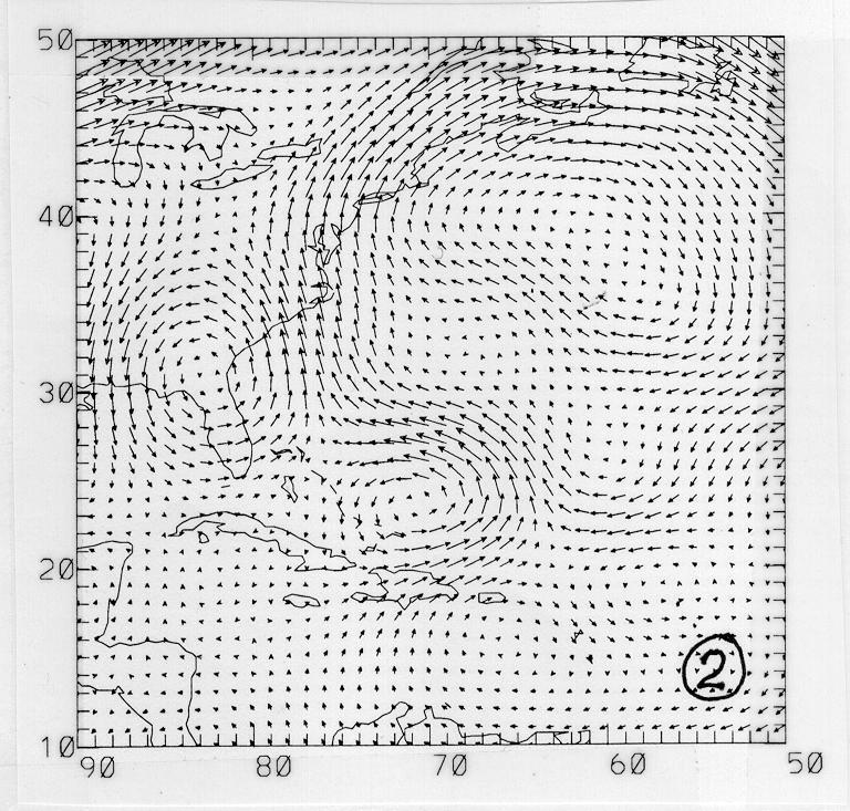
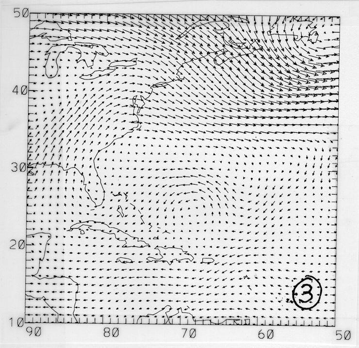
11 Exercise 1 - You are given deep-layer mean wind plots for 3 tropical cyclones (TCs) that were located in the vicinity of o N o W. - Also shown are the subsequent 72-h tracks taken by the 3 TCs. - Match up each deep-layer flow chart with the correct track. - Bonus: What were the names/years of the 3 TCs?

12
13
14
15
16 Exercise 2 - You are given deep-layer mean wind plots for 3 tropical cyclones (TCs) that were located in the vicinity of 15 o N 63 o W. - Also shown are the subsequent 72-h tracks taken by the 3 TCs. - Match up each deep-layer flow chart with the correct track. - What were the names/years of the 3 TCs?
17 1
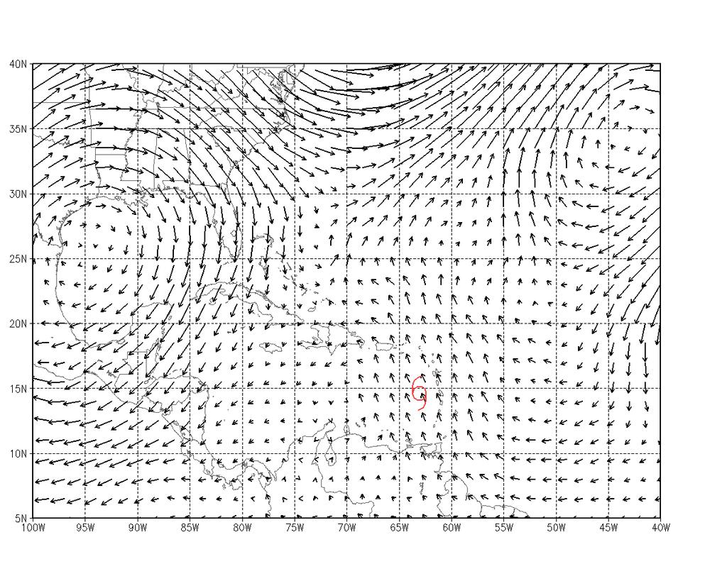
18 2
19 3

20 72-h Storm Tracks B C A
21 Numerical Weather Prediction Models for TC Track Prediction


22 Atlantic Track Error Trends Track errors increased in 2015 compared to 2014 (except at 120 h), and the last five years have been basically flat.

23 Track Model Trends EMXI best model at 48 h (again).
24 Hierarchy of TC Track Models Statistical CLIPER: Forecasts based on established relationships between stormspecific information (i.e., location and time of year) and the behavior of previous storms Simplified dynamical LBAR: simple two-dimensional dynamical track prediction model that solves the shallow-water equations initialized with vertically averaged ( mb) winds and heights from the GFS global model BAMD, BAMM, BAMS: Forecasts based on simplified dynamic representation of interaction with vortex and prevailing flow (trajectory plus beta) Dynamical GFDL, GFDN, GFS, NAVGEM, UKMET, ECMWF, HWRF: solve the threedimensional physical equations of motion that govern the atmosphere. Consensus TCON, TVCN, FSSE, AEMI: Based on multi-model or single-model ensembles 24
25 Climatology and Persistence Model (CLIPER) Statistical model, developed in 1972, extended from 3 to 5 days in 1998, re-derived in Developmental sample is (ATL), (EPAC). Required inputs: Current and 12-h old speed and direction of motion Current latitude and longitude Julian day, maximum wind No longer provides useful operational guidance, but is used as a benchmark for other models and the official forecast. If a model has lower mean errors than CLIPER it is said to be skillful. New version has been developed that can be extended to 7 days (or beyond). 25
26 Simplified Dynamical Models Beta and Advection (BAMS, BAMM, BAMD) Two-dimensional trajectory model. Uses steering determined from layer-averaged winds from a global model (GFS), smoothed to T25 resolution. Adds a correction to simulate the Beta effect. Three versions, representing different depths. The spread of these is a useful indicator of environmental vertical shear: BAMS (shallow): mb BAMM (medium): mb BAMD (deep): mb Limited-area Barotropic (LBAR) Barotropic dynamics: no temperature gradients or vertical shear Shallow water equations on Mercator projection solved using sine transforms, using mb layer average winds and heights and boundary conditions from the GFS Sum of idealized vortex and current motion vector added to the large-scale analysis Lack of baroclinic forcing means the model cannot accurately depict the evolution of large-scale synoptic steering features. Consequently, the model 26 has little or no skill beyond 1-2 days.
27 WHICH BAM TO USE? DEEP MEDIUM SHALLOW TROPICAL DEPRESSION TROPICAL STORM / CAT. 1-2 HURRICANE MAJOR HURRICANE
28 Three-Dimensional Dynamical Models Dynamical models May be global or limited area. May be grid point or spectral. May employ a bogussing scheme to represent the TC vortex. Global models Have inadequate resolution to define the TC inner core (eye and eyewall structure). Are often useful for forecasting TC size and outer wind structure. Have no lateral boundary conditions and therefore should have better performance at longer ranges than limited area models. Limited Area (Regional) models Generally have higher horizontal resolution and are therefore more capable of representing core structure and intensity change. Performance degrades at longer ranges. 28
29 Operational Global Models for TC Track Forecasting National Centers for Environmental Prediction (NCEP) Global Forecast System (GFS) United Kingdom Met Office Model (UKMET) Navy Global Environmental Model (NAVGEM) European Centre for Medium Range Weather Forecasting Model (ECMWF) Canadian Global Deterministic Prediction System (CMC) Each model consists of its own independent dynamical core, long- and short-wave radiation, cumulus convection, large-scale precipitation, surface fluxes, turbulent transports, and cloud microphysics. 29
30 Model Name and ATCF ID Global Forecast System (AVNO/AVNI) ECMWF model (ECMO/EMXI/ EMX2) U.K. Met Office Global Model (EGRR/UKMI) Navy Global Environmental Model (NVGM/NVGI) Canadian Global Deterministic Prediction System (CMC/CMCI) Numerical Method and Resolution Spectral (T1534L64) ~ 13 km horizontal (Semi-Lagrangian) Spectral (TCo1279) ~ 9 km horizontal (upgraded today!) Gridpoint Arakawa-C ~17 km horizontal Spectral (T359L50) ~ 37 km horizontal Gridpoint (1024X800 grid) ~ 25 km horizontal Vertical Coordinates 64 Hybrid Sigma Levels 137 Hybrid Sigma Levels 70 Hybrid Sigma Levels 50 Hybrid Sigma Levels 80 Hybrid Sigma Levels Cycling Frequency 6 hours, (to 180h) (00/06/12/18 UTC) 12 hours (to 240h) (00/12 UTC) 12 hours (to 144h) (00/12 UTC) 6 hours (to 144h) (00/06/12/18 UTC) 12 hours (to 240h) (00/12 UTC) Data Assimilation 4-D EnVar Hybrid (Proposed 2016 upgrade) 4D-Variational 4D-Variational / Ensemble Hybrid 4D-Variational / Ensemble Hybrid 4D-Variational / Ensemble Hybrid TC Bogus? Yes (occasionally); always assimilates central pressure No Assimilation of central pressure Yes No Convective Scheme Simplified Arakawa- Schubert [Arakawa and Schubert (1974) / Pan and Wu (1994)] Tiedke mass flux [Tiedke (1989)] UKMET [Gregory and Rowntree (1990)] Simplified Arakawa- Schubert Kain -Fritsch [Kain and Fritsch (1990, 1993)] Included in TVCN? Yes Yes Yes No No More info: gov/gfs v.uk/research/modellingsystems/unified-model l/metoc/nogaps/ rib2_glb_25km_e.html
31 Data Assimilation and Model Initialization for Tropical Cyclones All operational dynamical models assimilates large quantities of remotely-sensed observations, including microwave data from polar-orbiting satellites, ASCAT vectors, cloud-drift winds, etc. Generally, global models do not use any observations from the inner core Bogussing is used by some models to ensure that an appropriate representation of the vortex is present in the model initial condition. Examples include: Creating artificial (synthetic) data points to the model s data assimilation process (NAVGEM, GFS). Relocation of model-analyzed vortex to the correct location in first guess field (GFS), followed by real data assimilation. Use the model itself to create (spin up) a cyclone vortex (GFDL). 31
 3D-Var-EnKF Hybrid data assimilation scheme independent of GFS.")
32 Operational Regional Models for TC Track Forecasting Geophysical Fluid Dynamics Laboratory Model (GFDL) Initialization spins up a vortex from a separate run of the model, which replaces GFS fields over the circulation of the TC. Hurricane Weather Research and Forecasting Model (HWRF) 3D-Var-EnKF Hybrid data assimilation scheme independent of GFS. In 2013 the HWRF became the first operational system to assimilate inner core observations (Airborne Doppler Radar). Initially modeled after the GFDL, and many of the physics packages remain closely related. Each model consists of its own independent dynamical core, long- and short-wave radiation, cumulus convection, large-scale precipitation, surface fluxes, turbulent transports, and cloud microphysics. 32
33 33


34 Regional Modeling: Nesting and Storm Structure Three telescopic domains: 18km: 75x75 o ; 6km ~11x10 o 2km inner-most nest 6x5.5 o 34
35 Grid configuration Nesting HWRF 3-nests (coincident) (18 km 6 km 2km, upgrade for 2016) Force-feedback (two-way interactive) GFDL 3-nests(not coincident) (1/2-1/6-1/18 ) Interaction thru intra-nest fluxes Vertical Levels 61 Hybrid Sigma 42 Sigma Ocean coupling Convective parameterization MPIPOM (Trans-Atlantic and Eastern Pacific Basins) SAS mom. mix. + GFS shallow convection (6km and 18km) 2km nest none MPIPOM (Trans-Atlantic and Eastern Pacific Basins) SAS mom. mix. + GFS shallow convection Microphysics Ferrier-Aligo (upgrade for 2015) Ferrier Boundary layer Modified GFS non-local Modified GFS non-local Surface layer Modified GFDL GFDL (Moon et. al.) Land surface model NOAH LSM (upgrade for 2015) GFDL slab Dissipative heating Based on D-L Zhang Based on M-Y tke 2.5 Radiation RRTMG with partial cloudiness (upgrade for 2015) GFDL 39

 by making multiple runs of the model with slightly different (perturbed) initial conditions.")
36 Ensembles and Consensus An ensemble is a collection of forecasts all valid at the same forecast time. Can be formed from a single model (e.g., the GFS) by making multiple runs of the model with slightly different (perturbed) initial conditions. At some forecast time, the average of all the ensemble member s forecasts is the ensemble mean or consensus. The average distance of each member s forecast from the ensemble mean is the ensemble spread. 40
37 Ensembles and Consensus In the case of a single model ensemble, the perturbed initial conditions represent uncertainty in the initial analysis, but the model physics is the same for each ensemble member. In other words, the model is assumed to be perfect, with the only source of forecast error being initial analysis errors. Single model ensembles are typically run with a lower resolution version of a model that is also used for the deterministic (regular) run AEMN is the average of the GFS ensemble members (AEMI is the interpolated version of the ensemble mean) 41
38 GFS Ensemble example HURRICANE IKE BEST TRACK 42
39 GFS Ensemble example HURRICANE IKE BEST TRACK & GFS 9/8/08 12Z 43

40 GFS Ensemble example HURRICANE IKE BEST TRACK, GFS, & GFS ENSEMBLE 9/8/08 12Z 44
41 GFS Ensemble example AEMN GFS HURRICANE IKE BEST TRACK, GFS, GFS ENSEMBLE, & ENSEMBLE MEAN 9/8/08 12Z 45
42 Ensembles and Consensus Another way to form a consensus is to use an ensemble of different prediction models from the same initial time. This is called a multi-model ensemble. In a multi-model ensemble, the forecasts from the various member models differ due to differences in model initialization and model physics. TCON is the consensus (average) of GHMI, EGRI, HWFI, and GFSI (formerly AVNI). TVCN is the average of at least two of GFSI, EGRI, GHMI, HWFI, and EMXI. FSSE is a weighted average of several models and the previous official forecast (OFCI). Includes bias correctors to account for model error tendencies. 46
43 Ensembles and Consensus Often, the most successful consensus models are those formed from an ensemble of good performing models with a high degree of independence. Recently, some single-model consensus models (especially the GFS ensemble) have performed better than the deterministic version of the same model, and nearly as well as the multi-model consensus. Single model ensembles are most useful around day 5 and beyond. 47

44 120-hr TVCA Forecast 120-hr observed center location of Isaac Excellent example of a TVCN consensus: Hurricane Isaac, 0000 UTC 24 Aug 2012

45 72-hr TVCA forecast 72-hr observed center location of Debby Tropical Storm Debby 1800 UTC 23 June 2012 Of course, the consensus approach doesn t always work! Sometimes the forecaster might want to exclude certain models and form a selective consensus, if the discrepancies among the models can be resolved. Resolving these discrepancies is often more difficult than some may have you believe!
46 Early vs. Late Models Forecast cycle begins at synoptic time (e.g., 12Z), and forecast is released at t+3 h (15Z). The 12Z runs of the dynamical models (HWRF, GFS, etc.), are not available until 16Z-19Z, well after forecast is made and released. These models are known as late models Forecasts that are available in time for forecast deadlines are called early models (LBAR, BAMs, CLIPER). For the 12Z forecast cycle, the latest available run of each model is taken (from the 06Z or even 00Z cycle), and adjusted to apply at 12Z. These modified forecasts are known as interpolated models (HWFI, GFSI, etc.). 50
47 Early vs. Late Models Interpolated models are created by adjusting a smoothed version of the previous model run such that its 6-h forecast position exactly agrees with the current storm position. Then the rest of the forecast is adjusted by the same vector. 30 h 24 h 18 h 12 h Actual 12Z position 6 h 06Z GFS 51
48 Early vs. Late Models Interpolated models are created by adjusting a smoothed version of the previous model run such that its 6-h forecast position exactly agrees with the current storm position. Then the rest of the forecast is adjusted by the same vector. 24 h 12 h 12Z GFSI The early version of the model is what the forecasters actually have available to them when making a forecast OFCL is verified against the early models 52
49 Early and Late Model IDs Model Late ID Early ID Dynamical Track Multimodel Consensus Corrected Multimodel Consensus (none) (none) TVCN FSSE GFS AVNO/GFSO AVNI/GFSI GFS Ensemble AEMN/GEMO AEMI/GEMI ECMWF global model EMX/ECMO EMXI/ECOI UKMET global model EGRR UKXI/EGRI Canadian GDP CMC CMCI/CMC2 U.S. Navy NAVGEM NVGM NVGI HWRF HWRF HWFI GFDL GFDL GHMI Beta Advection Models (none) BAMS/BAMM/BAMD Limited Area Barotropic (none) LBAR Climatology and Persistence (none) CLP5/OCD5 NHC Previous Forecast (none) OFCI 53
 with skill just below the official forecasts and the consensus models. GFS ensemble mean (AEMI), HWFI, and EGRI next best models.")
50 2015 Track Guidance Official forecasts were very skillful, near or better than the consensus aids. EMXI best model, and the only one that beat the official forecast at 36 h and beyond. GFSI was a fair to good performer (second best individual model) with skill just below the official forecasts and the consensus models. GFS ensemble mean (AEMI), HWFI, and EGRI next best models. GHMI, CMCI, NVGI, GFNI trailed again in 2015.
 with skill just below the official forecasts and the consensus models. GFS ensemble mean (AEMI), HWFI, and EGRI next best models.")
51 Track Guidance Official forecasts were very skillful, near or better than the consensus aids. EMXI best individual model, and beat the official forecast at 48 h and beyond. GFSI was good performer (second best individual model) with skill just below the official forecasts and the consensus models. GFS ensemble mean (AEMI), HWFI, and EGRI next best models. GHMI and CMCI trailed.
52 Impact of 2015 GFS on HWRF New GFS degraded track/intensity forecasts 56
53 Expected Improvements to Regional Models in 2016: GFDL 57
54 Additional Tools and Considerations for TC Track Forecasting
55 Goerss Prediction of Consensus Error The magnitude of the consensus (TVCN) error can be statistically predicted based on: Model spread Initial and forecast intensity Forecast latitude and longitude displacements. (GPCE) Adjust the regression line upward so that 75% of the time the actual error is smaller than the predicted error. Adjusted regression gives you 75% confidence circles around TVCN.


56 Observed location 72 h 75% GPCE circle, Hurricane Emily 1200 UTC 13 July h 75% GPCE circle, Hurricane Rita 0600 UTC 22 September 2005 Observed location


57 NOAA G-IV AIRCRAFT: A SYNOPTIC SURVEILLANCE PLATFORM
58 Rita: 500 mb Dropsonde Observations 1800 UTC 21 Sept 0300 UTC 22 Sept 2005

59 Rita Dropsonde Impact Example

60 Dropsonde Impact

61 Track Forecasting at the NHC: Importance of Initial Motion Accurate estimate of initial motion is extremely important. Has dramatic impact on accuracy of the CLIPER model at shorter ranges. Initial motion vector is also used in some vortex bogussing schemes. 12-h NHC forecast is heavily weighted by the initial motion estimate. 11% 16% 25% 43% improvement w/bt motion Not always easy to determine, particularly for systems with ill-defined centers. 70
 that will not persist.")
62 Track Forecasting at the NHC: Determination of Initial Motion Initial motion typically computed using the average motion over the previous 6, 12, or 18 h. Shorter when known changes in track are occurring, longer when center location is uncertain. Initial motion estimate should not reflect short-term track wobbles (e.g., trochoidal oscillations) that will not persist. NHC philosophy is that it is better to lag events a little bit than to be going back and forth with analyses or forecasts. We will usually wait several hours before calling a change in track. 71

63 Trochoidal Motion Substantial oscillation (wobble) of the center of a TC about its mean motion vector Primarily a side effect of convective asymmetries in the inner core Amplitude of motions varies but higher-frequency wobbles lost in best track smoothing process Virtually impossible to forecast! 72
64 Track Forecasting at the NHC: Continuity Previous official forecast exerts a strong constraint on the current forecast. Credibility can be damaged by making big changes from one forecast to the next, and then having to go back to the original (flip-flop, windshield-wiper). Consequently, changes to the previous forecast are normally made in small increments. We strive for continuity within a given forecast (e.g., gradual changes in direction or speed from 12 to 24 to 36 h, etc. 73
65 Dennis Guidance 6 July 1200 UTC Official forecast near model consensus in extreme western FL panhandle.

66 Dennis Guidance 6 July 1800 UTC Guidance shifts sharply westward toward New Orleans. Official forecast nudged westward into AL.
67 Dennis Guidance 7 July 0000 UTC Little overall change to guidance, but NGPI shifts slightly eastward. Little change in official forecast.
68 Dennis Guidance 7 July 0600 UTC Rest of the guidance shifts sharply eastward, leaving official forecast near the center of the guidance envelope (and very close to the actual track of Dennis.
69 Track Forecasting at the NHC: Using Models Dynamical model consensus is an excellent first guess for the forecast (and often a good final guess!). Continuity dictates that it must be considered in view of the previous official forecast. Evaluate the large-scale environment using conventional data and satellite imagery (e.g., water vapor) Try to assess steering influences so that you understand and perhaps evaluate the model solutions Compare the models forecast of the environmental features, not just the TC tracks. Evaluate the initialization of the TC in the model fields. Unrealistic TC can affect the likelihood of a successful forecast. Consider the recent performance of the various models, both in terms of accuracy and consistency. Spread of models can dictate forecaster confidence. 78

70 Large-Scale Steering Flow Ridge Anticyclonic Shear Axis Trough Ridge Upper Level Low L Ridge H Broad Upper Level Anticyclone Allow the forecaster to see features in the storm environment that could affect the future track and intensity of the cyclone.

71 Bad Initialization for Tropical Storm Gordon 1200 UTC 11 September

72 How to resolve the difference between guidance models?
 would argue against Jeanne being carried eastward by upperlevel westerlies.")
73 Poor organization (esp. lack of deep convection in the core) would argue against Jeanne being carried eastward by upperlevel westerlies. X This reasoning allowed the forecasters to largely disregard the GFS and form a selective consensus of the remaining models.


74 Lack of consistency in GFDL forecasts for Wilma 19 October Z 06Z 12Z 18Z
75 HURRICANE WILMA DISCUSSION NUMBER 18 NWS TPC/NATIONAL HURRICANE CENTER MIAMI FL 5 PM EDT WED OCT AGREEMENT AMONG THE TRACK GUIDANCE MODELS...WHICH HAD BEEN VERY GOOD OVER THE PAST COUPLE OF DAYS...HAS COMPLETELY COLLAPSED TODAY. THE 06Z RUNS OF THE GFS...GFDL...AND NOGAPS MODELS ACCELERATED WILMA RAPIDLY TOWARD NEW ENGLAND UNDER THE INFLUENCE OF A LARGE LOW PRESSURE SYSTEM IN THE GREAT LAKES REGION. ALL THREE OF THESE MODELS HAVE BACKED OFF OF THIS SOLUTION...WITH THE GFDL SHOWING AN EXTREME CHANGE...WITH ITS 5-DAY POSITION SHIFTING A MERE 1650 NMI FROM ITS PREVIOUS POSITION IN MAINE TO THE WESTERN TIP OF CUBA. THERE IS ALMOST AS MUCH SPREAD IN THE 5-DAY POSITIONS OF THE 12Z GFS ENSEMBLE MEMBERS...WHICH RANGE FROM THE YUCATAN TO WELL EAST OF THE DELMARVA PENINSULA. WHAT THIS ILLUSTRATES IS THE EXTREME SENSITIVITY OF WILMA'S FUTURE TRACK TO ITS INTERACTION WITH THE GREAT LAKES LOW. OVER THE PAST COUPLE OF DAYS...WILMA HAS BEEN MOVING SLIGHTLY TO THE LEFT OR SOUTH OF THE MODEL GUIDANCE...AND THE LEFT-MOST OF THE GUIDANCE SOLUTIONS ARE NOW SHOWING WILMA DELAYING OR MISSING THE CONNECTION WITH THE LOW. I HAVE SLOWED THE OFFICIAL FORECAST JUST A LITTLE BIT AT THIS TIME...BUT IF WILMA CONTINUES TO MOVE MORE TO THE LEFT THAN EXPECTED...SUBSTANTIAL CHANGES TO THE OFFICIAL FORECAST MAY HAVE TO BE MADE DOWN THE LINE. NEEDLESS TO SAY...CONFIDENCE IN THE FORECAST TRACK...ESPECIALLY THE TIMING...HAS DECREASED CONSIDERABLY....DELETED DISCUSSION TEXT... FORECASTER FRANKLIN FORECAST POSITIONS AND MAX WINDS INITIAL 19/2100Z 17.7N 83.7W 140 KT 12HR VT 20/0600Z 18.0N 84.6W 135 KT 24HR VT 20/1800Z 19.2N 85.6W 145 KT 36HR VT 21/0600Z 20.4N 86.2W 145 KT 48HR VT 21/1800Z 21.6N 86.3W 120 KT 72HR VT 22/1800Z 24.0N 84.5W 105 KT 96HR VT 23/1800Z 27.5N 79.0W 80 KT 120HR VT 24/1800Z 36.0N 70.0W 65 KT


76 Forecast Verification OFCL Error Distributions and Cone Radii The size of the NHC forecast uncertainty cone is now determined by the 67 th percentiles of the NHC official forecast errors over the previous 5 year period. The cone is formed by connecting circles at 12, 24, 36 h, etc., where the radius of each circle is given by the 67 th percentile. The circles are reevaluated each season, and they are tending to get smaller as years go by.
77 2016 Atlantic Cone Forecast period (h) Circle radii ( n mi) Percent change from % % % % % % % The Atlantic cone will be a little smaller in 2016 through 96 h, and slightly larger at 120 h.
78 Concluding Remarks Multi-level dynamical models are the most skillful models for TC track prediction. Among these models, the ECMWF and GFS have provided the best guidance overall in recent years, but performance does vary significantly from year to year (or storm to storm). A consensus formed from an ensemble of dynamical models is typically more skillful than the best dynamical model (but not in 2015). Single-model ensembles appear to most useful for longerrange (5 days and beyond). NHC forecasters have philosophical constraints on the official forecast that results in a certain amount of response lag (and may contribute to our errors lagging the consensus). While it is possible to beat the models from time to time, model performance has improved significantly over the years, and they are very difficult to beat on a consistent basis. 87
Tropical Cyclone Track Prediction
 Tropical Cyclone Track Prediction Richard J. Pasch and David A. Zelinsky National Hurricane Center 2017 RA-IV Workshop on Hurricane Forecasting and Warning March 7, 2017 Outline Basic Dynamics Guidance
The Evolution and Use of Objective Forecast Guidance at NHC
 The Evolution and Use of Objective Forecast Guidance at NHC James L. Franklin Branch Chief, Hurricane Specialist Unit National Hurricane Center 2010 EMC/MMM/DTC Workshop 1 Hierarchy of TC Track Models
OPERATIONAL CONSIDERATIONS FOR HURRICANE MODEL DIAGNOSTICS / VERIFICATION
 OPERATIONAL CONSIDERATIONS FOR HURRICANE MODEL DIAGNOSTICS / VERIFICATION Richard J. Pasch National Hurricane Center Hurricane Diagnostics and Verification Workshop Miami, Florida 4 May 2009 NOAA/NESDIS
Ensemble Prediction Systems
 Ensemble Prediction Systems Eric S. Blake & Michael J. Brennan National Hurricane Center 8 March 2016 Acknowledgements to Rick Knabb and Jessica Schauer 1 Why Aren t Models Perfect? Atmospheric variables
11A.1 PREDICTION OF TROPICAL CYCLONE TRACK FORECAST ERROR FOR HURRICANES KATRINA, RITA, AND WILMA
 11A.1 PREDICTION OF TROPICAL CYCLONE TRACK FORECAST ERROR FOR HURRICANES KATRINA, RITA, AND WILMA James S. Goerss* Naval Research Laboratory, Monterey, California 1. INTRODUCTION Consensus tropical cyclone
Ensemble Prediction Systems
 Ensemble Prediction Systems Eric Blake National Hurricane Center 7 March 2017 Acknowledgements to Michael Brennan 1 Question 1 What are some current advantages of using single-model ensembles? A. Estimates
Motivation & Goal. We investigate a way to generate PDFs from a single deterministic run
 Motivation & Goal Numerical weather prediction is limited by errors in initial conditions, model imperfections, and nonlinearity. Ensembles of an NWP model provide forecast probability density functions
Advancements in Operations and Research on Hurricane Modeling and Ensemble Prediction System at EMC/NOAA
 Advancements in Operations and Research on Hurricane Modeling and Ensemble Prediction System at EMC/NOAA Zhan Zhang and Vijay Tallapragada EMC/NCEP/NOAA/DOC Acknowledgements: HWRF Team Members at EMC,
NHC Ensemble/Probabilistic Guidance Products
 NHC Ensemble/Probabilistic Guidance Products Michael Brennan NOAA/NWS/NCEP/NHC Mark DeMaria NESDIS/STAR HFIP Ensemble Product Development Workshop 21 April 2010 Boulder, CO 1 Current Ensemble/Probability
Hurricane Structure: Theory and Application. John Cangialosi National Hurricane Center
 Hurricane Structure: Theory and Application John Cangialosi National Hurricane Center World Meteorological Organization Workshop Is this Tropical, Subtropical, or Extratropical? Subtropical Tropical Extratropical
The Use of GPS Radio Occultation Data for Tropical Cyclone Prediction. Bill Kuo and Hui Liu UCAR
 The Use of GPS Radio Occultation Data for Tropical Cyclone Prediction Bill Kuo and Hui Liu UCAR Current capability of the National Hurricane Center Good track forecast improvements. Errors cut in half
Overview of HFIP FY10 activities and results
 Overview of HFIP FY10 activities and results Bob Gall HFIP Annual Review Meeting Miami Nov 9, 2010 Outline In this presentation I will show a few preliminary results from the summer program. More detail
Model assessment using a multi-metric ranking technique
 Philosophy Model assessment using a multi-metric ranking technique Pat Fitzpatrick and Yee Lau, Mississippi State University at Stennis Ghassan Alaka and Frank Marks, NOAA AOML Hurricane Research Division
Track Forecasting Are TCs unpredictable'?
 Track Forecasting Are TCs unpredictable'? 1/25 Conceptual frameworks The process NWP Consensus processes Ensembles 2/25 Does track depend upon the intensity? Changes in inner core processes have little
Numerical Weather Prediction: Data assimilation. Steven Cavallo
 Numerical Weather Prediction: Data assimilation Steven Cavallo Data assimilation (DA) is the process estimating the true state of a system given observations of the system and a background estimate. Observations
THE IMPACT OF SATELLITE-DERIVED WINDS ON GFDL HURRICANE MODEL FORECASTS
 THE IMPACT OF SATELLITE-DERIVED WINDS ON GFDL HURRICANE MODEL FORECASTS Brian J. Soden 1 and Christopher S. Velden 2 1) Geophysical Fluid Dynamics Laboratory National Oceanic and Atmospheric Administration
Hurricane Structure: Theory and Diagnosis
 Hurricane Structure: Theory and Diagnosis 7 March, 2016 World Meteorological Organization Workshop Chris Landsea Chris.Landsea@noaa.gov National Hurricane Center, Miami Outline Structure of Hurricanes
Recent COAMPS-TC Development and Future Plans
 Recent COAMPS-TC Development and Future Plans James D. Doyle, Jon Moskaitis, Rich Hodur1, Sue Chen, Hao Jin, Yi Jin, Will Komaromi, Alex Reinecke, David Ryglicki, Dan Stern2, Shouping Wang Naval Research
COAMPS-TC 2015 Version, Performance, and Future Plans
 COAMPS-TC 2015 Version, Performance, and Future Plans James D. Doyle, R. Hodur 1, J. Moskaitis, S. Chen, E. Hendricks 2, H. Jin, Y. Jin, A. Reinecke, S. Wang Naval Research Laboratory, Monterey, CA 1 IES/SAIC,
The Properties of Convective Clouds Over the Western Pacific and Their Relationship to the Environment of Tropical Cyclones
 The Properties of Convective Clouds Over the Western Pacific and Their Relationship to the Environment of Tropical Cyclones Principal Investigator: Dr. Zhaoxia Pu Department of Meteorology, University
COLORADO STATE UNIVERSITY FORECAST OF ATLANTIC HURRICANE ACTIVITY FROM AUGUST 16 AUGUST 29, 2013
 COLORADO STATE UNIVERSITY FORECAST OF ATLANTIC HURRICANE ACTIVITY FROM AUGUST 16 AUGUST 29, 2013 We expect that the next two weeks will be characterized by above-average amounts (greater than 130 percent)
COLORADO STATE UNIVERSITY FORECAST OF ATLANTIC HURRICANE ACTIVITY FROM AUGUST 31 SEPTEMBER 13, 2012
 COLORADO STATE UNIVERSITY FORECAST OF ATLANTIC HURRICANE ACTIVITY FROM AUGUST 31 SEPTEMBER 13, 2012 We expect that the next two weeks will be characterized by average amounts (70-130 percent) of activity
Track sensitivity to microphysics and radiation
 Track sensitivity to microphysics and radiation Robert Fovell and Yizhe Peggy Bu, UCLA AOS Brad Ferrier, NCEP/EMC Kristen Corbosiero, U. Albany 11 April 2012 rfovell@ucla.edu 1 Background WRF-ARW, including
GFDL Hurricane Model Ensemble Performance During the 2012 Hurricane Season
 GFDL Hurricane Model Ensemble Performance During the 2012 Hurricane Season Tim Marchok (NOAA / GFDL) Matt Morin (DRC HPTG / GFDL) Morris Bender (NOAA / GFDL) HFIP Team Telecon 12 December 2012 Acknowledgments:
Upgrade of JMA s Typhoon Ensemble Prediction System
 Upgrade of JMA s Typhoon Ensemble Prediction System Masayuki Kyouda Numerical Prediction Division, Japan Meteorological Agency and Masakazu Higaki Office of Marine Prediction, Japan Meteorological Agency
Tropical Cyclone Report Hurricane Rafael (AL172012) October Lixion A. Avila National Hurricane Center 14 January 2013
 October Lixion A. Avila National Hurricane Center 14 January 2013") Tropical Cyclone Report Hurricane Rafael (AL172012) 12-17 October 2012 Lixion A. Avila National Hurricane Center 14 January 2013 Rafael moved across the northern Leeward Islands as a tropical storm and
Tropical Cyclone Report Hurricane Rafael (AL172012) 12-17 October 2012 Lixion A. Avila National Hurricane Center 14 January 2013 Rafael moved across the northern Leeward Islands as a tropical storm and
SIXTH INTERNATIONAL WORKSHOP on TROPICAL CYCLONES. Working Group: Phillipe Caroff, Jeff Callaghan, James Franklin, Mark DeMaria
 WMO/CAS/WWW Topic 0.1: Track forecasts SIXTH INTERNATIONAL WORKSHOP on TROPICAL CYCLONES Rapporteur: E-mail: Lixion A. Avila NOAA/National Hurricane Center 11691 SW 17th Street Miami, FL 33165-2149, USA
ATCF: LESSONS LEARNED ON TC CONSENSUS FORECASTING. John Knaff, NOAA/NESDIS and Buck Sampson, NRL, Monterey
 ATCF: LESSONS LEARNED ON TC CONSENSUS FORECASTING John Knaff, NOAA/NESDIS and Buck Sampson, NRL, Monterey Definitions TC tropical cyclone Aid individual model forecast Guidance any method that provides
EARLY WARNINGS FOR HURRICANES
 1 EARLY WARNINGS FOR HURRICANES Dr. José Rubiera National Forecasting Center Instituto de Meteorología, Cuba Thematic Session Cluster 2 World Conference on Disaster Reduction Kobe, Japan, January 18 22,
Tropical cyclone simulations and predictions with GFDL s prototype global cloud resolving model
 Tropical cyclone simulations and predictions with GFDL s prototype global cloud resolving model S.-J. Lin and GFDL model development teams NOAA/Geophysical Fluid Dynamics Laboratory Workshop on High-Resolution
John Gyakum, Ron McTaggart-Cowan, Eyad Atallah, and Lance Bosart
 Hurricane Juan (2003): Forecasting and numerical simulation John Gyakum, Ron McTaggart-Cowan, Eyad Atallah, and Lance Bosart Outline Case Background Operational Forecasts and NWP Improved NWP Guidance
Use of the GFDL Vortex Tracker
 Use of the GFDL Vortex Tracker Tim Marchok NOAA / Geophysical Fluid Dynamics Laboratory WRF Tutorial for Hurricanes January 24, 2018 Outline History & description of the GFDL vortex tracker Inputs & Outputs
Tropical Cyclone Formation/Structure/Motion Studies
 Tropical Cyclone Formation/Structure/Motion Studies Patrick A. Harr Department of Meteorology Naval Postgraduate School Monterey, CA 93943-5114 phone: (831) 656-3787 fax: (831) 656-3061 email: paharr@nps.edu
COLORADO STATE UNIVERSITY FORECAST OF ATLANTIC HURRICANE ACTIVITY FROM AUGUST 30 SEPTEMBER 12, 2013
 COLORADO STATE UNIVERSITY FORECAST OF ATLANTIC HURRICANE ACTIVITY FROM AUGUST 30 SEPTEMBER 12, 2013 We expect that the next two weeks will be characterized by average amounts (70-130 percent) of activity
Early Guidance for Tropical Weather Systems
 Early Guidance for Tropical Weather Systems Understanding What s Out There Jennifer McNatt National Weather Service Material from: Dan Brown, Mike Brennan and John Cangialosi, National Hurricane Center
Advanced Research WRF High Resolution Simulations of Hurricanes Katrina, Rita and Wilma (2005)
") Advanced Research WRF High Resolution Simulations of Hurricanes Katrina, Rita and Wilma (2005) Kristen L. Corbosiero, Wei Wang, Yongsheng Chen, Jimy Dudhia and Christopher Davis National Center for Atmospheric
Advanced Research WRF High Resolution Simulations of Hurricanes Katrina, Rita and Wilma (2005) Kristen L. Corbosiero, Wei Wang, Yongsheng Chen, Jimy Dudhia and Christopher Davis National Center for Atmospheric
An Overview of COAMPS-TC Development and Real-Time Tests
 An Overview of COAMPS-TC Development and Real-Time Tests James D. Doyle, R. Hodur 1, P. Black, S. Chen, J. Cummings 2, E. Hendricks, T. Holt, H. Jin, Y. Jin, C.-S. Liou, J. Moskaitis, M. Peng, A. Reinecke,
COLORADO STATE UNIVERSITY FORECAST OF ATLANTIC HURRICANE ACTIVITY FROM AUGUST 17 AUGUST 30, 2012
 COLORADO STATE UNIVERSITY FORECAST OF ATLANTIC HURRICANE ACTIVITY FROM AUGUST 17 AUGUST 30, 2012 We expect that the next two weeks will be characterized by above-average amounts (greater than 130 percent)
Storm Summary for Hurricane Joaquin
 Storm Summary for Hurricane Joaquin Wednesday, September 30, 2015 at 5 PM EDT (Output from Hurrevac, based on National Hurricane Center Forecast Advisory #12) Joaquin is currently a Category 1 hurricane
T-PARC and TCS08 (Submitted by Pat Harr, Russell Elsberry and Tetsuo Nakazawa)
") WORLD METEOROLOGICAL ORGANIZATION COMMISSION FOR ATMOSPHERIC SCIENCES INTERNATIONAL CORE STEERING COMMITTEE FOR THORPEX Eighth Session DWD, Offenbach (2 4 November 2009) CAS/ICSC-8/DOC4.1 (3 X.2009) Item:
WORLD METEOROLOGICAL ORGANIZATION COMMISSION FOR ATMOSPHERIC SCIENCES INTERNATIONAL CORE STEERING COMMITTEE FOR THORPEX Eighth Session DWD, Offenbach (2 4 November 2009) CAS/ICSC-8/DOC4.1 (3 X.2009) Item:
The impact of assimilation of microwave radiance in HWRF on the forecast over the western Pacific Ocean
 The impact of assimilation of microwave radiance in HWRF on the forecast over the western Pacific Ocean Chun-Chieh Chao, 1 Chien-Ben Chou 2 and Huei-Ping Huang 3 1Meteorological Informatics Business Division,
A Look Back at the 2012 Hurricane Season and a Look Ahead to 2013 & Beyond. Daniel Brown National Hurricane Center Miami, Florida 24 April 2013
 A Look Back at the 2012 Hurricane Season and a Look Ahead to 2013 & Beyond Daniel Brown National Hurricane Center Miami, Florida 24 April 2013 2012 Atlantic Verification Good News- Lots of Accuracy Records
HMON (HNMMB): Development of a new Hurricane model for NWS/NCEP operations
: Development of a new Hurricane model for NWS/NCEP operations") 1 HMON (HNMMB): Development of a new Hurricane model for NWS/NCEP operations Avichal Mehra, EMC Hurricane and Mesoscale Teams Environmental Modeling Center NOAA / NWS / NCEP HMON: A New Operational Hurricane
1 HMON (HNMMB): Development of a new Hurricane model for NWS/NCEP operations Avichal Mehra, EMC Hurricane and Mesoscale Teams Environmental Modeling Center NOAA / NWS / NCEP HMON: A New Operational Hurricane
A Deterministic Rapid Intensification Aid
 AUGUST 2011 S A M P S O N E T A L. 579 A Deterministic Rapid Intensification Aid CHARLES R. SAMPSON Naval Research Laboratory, Monterey, California JOHN KAPLAN NOAA/AOML/Hurricane Research Division, Miami,
COLORADO STATE UNIVERSITY FORECAST OF ATLANTIC HURRICANE ACTIVITY FROM AUGUST 4-17, 2015
 COLORADO STATE UNIVERSITY FORECAST OF ATLANTIC HURRICANE ACTIVITY FROM AUGUST 4-17, 2015 We expect that the next two weeks will be characterized by below-average amounts (
JTWC use of ensemble products. Matthew Kucas Joint Typhoon Warning Center Pearl Harbor, HI
 Matthew Kucas Joint Typhoon Warning Center Pearl Harbor, HI Overview Tropical cyclone track forecasting Deterministic model consensus and single-model ensembles as track forecasting aids Conveying uncertainty
Methodology for 2013 Stream 1.5 Candidate Evaluation
 Methodology for 2013 Stream 1.5 Candidate Evaluation 20 May 2013 TCMT Stream 1.5 Analysis Team: Louisa Nance, Mrinal Biswas, Barbara Brown, Tressa Fowler, Paul Kucera, Kathryn Newman, Jonathan Vigh, and
Forecast Challenges of the 2017 Hurricane Season and NHC Priorities for 2018
 Forecast Challenges of the 2017 Hurricane Season and NHC Priorities for 2018 Michael J. Brennan, Mark DeMaria, Eric S. Blake, Richard J. Pasch, Andrew Penny Annual HFIP Meeting 8 November 2017 Outline
2012 AHW Stream 1.5 Retrospective Results
 2012 AHW Stream 1.5 Retrospective Results Ryan D. Torn, Univ. Albany, SUNY Chris Davis, Wei Wang, Jimy Dudhia, Tom Galarneau, Chris Snyder, James Done, NCAR/NESL/MMM Overview Since participation in HFIP
BASIN-SCALE HWRF: Evaluation of 2017 Real-Time Forecasts
 BASIN-SCALE HWRF: Evaluation of 2017 Real-Time Forecasts HARVEY IRMA MARIA Ghassan Alaka1,2, Xuejin Zhang1,2, Gopal2, Frank Marks2, Mu-Chieh Ko1,2, Russell St. Fleur1,2 Acknowledgements: NOAA/NWS/EMC,
Methodology for 2014 Stream 1.5 Candidate Evaluation
 Methodology for 2014 Stream 1.5 Candidate Evaluation 29 July 2014 TCMT Stream 1.5 Analysis Team: Louisa Nance, Mrinal Biswas, Barbara Brown, Tressa Fowler, Paul Kucera, Kathryn Newman, and Christopher
Meteorology Lecture 24
 Meteorology Lecture 24 Robert Fovell rfovell@albany.edu 1 Important notes These slides show some figures and videos prepared by Robert G. Fovell (RGF) for his Meteorology course, published by The Great
Superstorm Sandy. Joe Sienkiewicz NOAA Ocean Prediction Center
 Superstorm Sandy Joe Sienkiewicz NOAA Ocean Prediction Center Thanks to: Dr. Louis Uccellini, NCEP Director Dr. David Novak, HPC Dr. Richard Knabb, NHC Director Evolution Jet Stream 10/29/12 12Z (Blue)
NWS Operational Marine and Ocean Forecasting. Overview. Ming Ji. Ocean Prediction Center National Weather Service/NCEP. CIOSS/CoRP
 NWS Operational Marine and Ocean Forecasting Overview Ming Ji Ocean Prediction Center National Weather Service/NCEP CIOSS/CoRP CoRP Symposium Corvallis, OR Aug. 12-13, 13, 2008 Titanic Telegram Marine
11A.3 The Impact on Tropical Cyclone Predictions of a Major Upgrade to the Met Office Global Model
 11A.3 The Impact on Tropical Cyclone Predictions of a Major Upgrade to the Met Office Global Model Julian T. Heming * Met Office, Exeter, UK 1. BACKGROUND TO MODEL UPGRADE The last major upgrade to the
National Oceanic and Atmospheric Administration Hurricane Forecast Improvement Program Five-Year Strategic Plan
 National Oceanic and Atmospheric Administration Hurricane Forecast Improvement Program Five-Year Strategic Plan 13 December 2010 Frederick Toepfer HFIP Program Manager Robert Gall HFIP Development Manager
Operational and Statistical Prediction of Rapid Intensity Change. Mark DeMaria and Eric Blake, NCEP/NHC John Kaplan, AOML/HRD
 Operational and Statistical Prediction of Rapid Intensity Change Mark DeMaria and Eric Blake, NCEP/NHC John Kaplan, AOML/HRD Outline Evaluation of NHC forecasts and deterministic models for rapid intensification
NCEP Operational Hurricane Modeling System. HWRF Performance Verification in 2015
 1 NCEP Operational Hurricane Modeling System HWRF Performance Verification in 2015 The HWRF Team Environmental Modeling Center, NCEP NOAA/NCWCP, College Park, MD 20740, USA. Zhan Zhang, Samuel Trahan,
COLORADO STATE UNIVERSITY FORECAST OF ATLANTIC HURRICANE ACTIVITY FROM SEPTEMBER 28 OCTOBER 11, 2011
 COLORADO STATE UNIVERSITY FORECAST OF ATLANTIC HURRICANE ACTIVITY FROM SEPTEMBER 28 OCTOBER 11, 2011 We expect that the next two weeks will be characterized by below-average amounts (less than 70 percent)
COLORADO STATE UNIVERSITY FORECAST OF ATLANTIC HURRICANE ACTIVITY FROM AUGUST 2 AUGUST 15, 2013
 COLORADO STATE UNIVERSITY FORECAST OF ATLANTIC HURRICANE ACTIVITY FROM AUGUST 2 AUGUST 15, 2013 We expect that the next two weeks will be characterized by below-average amounts (
P1.6 Simulation of the impact of new aircraft and satellite-based ocean surface wind measurements on H*Wind analyses
 P1.6 Simulation of the impact of new aircraft and satellite-based ocean surface wind measurements on H*Wind analyses Timothy L. Miller 1, R. Atlas 2, P. G. Black 3, J. L. Case 4, S. S. Chen 5, R. E. Hood
Storm Summary for Hurricane Jose
 Storm Summary for Hurricane Jose Tuesday, September 19, 2017 at 11 AM EDT (Output from Hurrevac, based on National Hurricane Center Forecast Advisory #57) Jose is currently a Category 1 hurricane on the
Final Examination, MEA 443 Fall 2008, Lackmann
 Place an X here to count it double! Name: Final Examination, MEA 443 Fall 2008, Lackmann If you wish to have the final exam count double and replace your midterm score, place an X in the box above. As
ARW/EnKF performance for the 2009 Hurricane Season
 ARW/EnKF performance for the 2009 Hurricane Season Ryan D. Torn, Univ. at Albany, SUNY Chris Davis, Steven Cavallo, Chris Snyder, Wei Wang, James Done, NCAR/MMM 4 th EnKF Workshop 8 April 2010, Rensselaerville,
On the Ability of Global Ensemble Prediction Systems to Predict Tropical Cyclone Track Probabilities
 APRIL 2010 M A J U M D A R A N D F I N O C C H I O 659 On the Ability of Global Ensemble Prediction Systems to Predict Tropical Cyclone Track Probabilities SHARANYA J. MAJUMDAR AND PETER M. FINOCCHIO University
Aircraft Observations of Tropical Cyclones. Robert Rogers NOAA/AOML Hurricane Research Division Miami, FL
 Aircraft Observations of Tropical Cyclones Robert Rogers NOAA/AOML Hurricane Research Division Miami, FL 1 Motivation Why are observations important? Many important physical processes within hurricanes
Wind Speed Probability Products
 Wind Speed Probability Products Daniel Brown National Hurricane Center 2018 WMO Course 6 March 2018 Wind Speed Probabilities A Tool to Deal with Uncertainty Hurricane Irene Advisory Number 12 Issued 5:00
Structure & Intensity Change: Future Directions IWTC VI, Topic 1
 Structure & Intensity Change: Future Directions IWTC VI, Topic 1 Chair: Rob Rogers Rapporteurs Environmental Impacts (J. Evans) Inner Core Impacts (E. Ritchie) Oceanic Impacts (N. Shay) Observational Capabilities
Impact of Assimilating Aircraft Reconnaissance Observations in Operational HWRF
 Impact of Assimilating Aircraft Reconnaissance Observations in Operational HWRF Mingjing Tong, Vijay Tallapragada, Emily Liu, Weiguo Wang, Chanh Kieu, Qingfu Liu and Banglin Zhan Environmental Modeling
Experiments of Hurricane Initialization with Airborne Doppler Radar Data for the Advancedresearch Hurricane WRF (AHW) Model
 Model") Experiments of Hurricane Initialization with Airborne Doppler Radar Data for the Advancedresearch Hurricane WRF (AHW) Model Qingnong Xiao 1, Xiaoyan Zhang 1, Christopher Davis 1, John Tuttle 1, Greg Holland
Experiments of Hurricane Initialization with Airborne Doppler Radar Data for the Advancedresearch Hurricane WRF (AHW) Model Qingnong Xiao 1, Xiaoyan Zhang 1, Christopher Davis 1, John Tuttle 1, Greg Holland
Lessons Learned from Hurricane Harvey and Irma
 EOL Visit to NSF 3 March 2016 Lessons Learned from Hurricane Harvey and Irma Wen-Chau Lee National Center for Atmospheric Research 23 November 2017 Outline: Meteorological elements of the active 2017 Atlantic
NHC Activities, Plans, and Needs
 NHC Activities, Plans, and Needs HFIP Diagnostics Workshop August 10, 2012 NHC Team: David Zelinsky, James Franklin, Wallace Hogsett, Ed Rappaport, Richard Pasch NHC Activities Activities where NHC is
Tropical Storm List
 Tropical Storm Email List http://tstorms.org/ tropical-storms@tstorms.org Tropical-Storms is a mailing list only for those who are professionally active in either the research or forecasting of tropical
Recent advances in Tropical Cyclone prediction using ensembles
 Recent advances in Tropical Cyclone prediction using ensembles Richard Swinbank, with thanks to Many colleagues in Met Office, GIFS-TIGGE WG & others HC-35 meeting, Curacao, April 2013 Recent advances
2017 Year in review: JTWC TC Activity, Forecast Challenges, and Developmental Priorities
 2017 Year in review: JTWC TC Activity, Forecast Challenges, and Developmental Priorities Mean Annual TC Activity????????? Hurricane Forecast Improvement Program Annual Review 8-9 NOV 2017 Brian Strahl,
A Preliminary Exploration of the Upper Bound of Tropical Cyclone Intensification
 A Preliminary Exploration of the Upper Bound of Tropical Cyclone Intensification Jonathan L. Vigh (NCAR/RAL) Kerry Emanuel (MIT) Mrinal K. Biswas (NCAR/RAL) Eric A. Hendricks (Naval Postgraduate School)
EMC multi-model ensemble TC track forecast
 EMC multi-model ensemble TC track forecast Jiayi Peng*, Yuejian Zhu and Richard Wobus* *IMSG at Environmental Modeling Center Environmental Modeling Center /NCEP/NOAA, Camp Springs, MD 2746 Acknowledgements:
Tropical Cyclone Modeling and Data Assimilation. Jason Sippel NOAA AOML/HRD 2018 WMO Workshop at NHC
 Tropical Cyclone Modeling and Data Assimilation Jason Sippel NOAA AOML/HRD 2018 WMO Workshop at NHC Outline History of TC forecast improvements in relation to model development Ongoing modeling/da developments
Evolution of the GFDL hurricane model in research and transition to NMC operations
 Evolution of the GFDL hurricane model in research and transition to NMC operations Robert E. Tuleya (Saic, EMC & CCPO/ODU) Morris Bender (GFDL) Isaac Ginis (URI) Tim Marchok (GFDL) URI/GSO Y. Kurihara
ESCI 241 Meteorology Lesson 19 Tropical Cyclones Dr. DeCaria
 ESCI 241 Meteorology Lesson 19 Tropical Cyclones Dr. DeCaria READING: Chapter 16 GENERAL A tropical cyclone is a large, low-pressure system that forms over the tropical oceans. Tropical cyclones are classified
Ensemble TC Track/Genesis Products in
 Ensemble TC Track/Genesis Products in Parallel @NCO Resolution Members Daily Frequency Forecast Length NCEP ensemble (AEMN-para) GFS T574L64-33km(12/02/15) 20+1_CTL 00, 06, 12, 18 UTC 16 days (384hrs)
University of Miami/RSMAS
 Observing System Simulation Experiments to Evaluate the Potential Impact of Proposed Observing Systems on Hurricane Prediction: R. Atlas, T. Vukicevic, L.Bucci, B. Annane, A. Aksoy, NOAA Atlantic Oceanographic
Typhoon Relocation in CWB WRF
 Typhoon Relocation in CWB WRF L.-F. Hsiao 1, C.-S. Liou 2, Y.-R. Guo 3, D.-S. Chen 1, T.-C. Yeh 1, K.-N. Huang 1, and C. -T. Terng 1 1 Central Weather Bureau, Taiwan 2 Naval Research Laboratory, Monterey,
ABSTRACT 1 INTRODUCTION P2G.4 HURRICANE DEFLECTION BY SEA SURFACE TEMPERATURE ANOMALIES.
 P2G.4 HURRICANE DEFLECTION BY SEA SURFACE TEMPERATURE ANOMALIES. M.E. McCulloch, J.T. Heming and J.D. Stark Met Office, Exeter, UK April 23, 2008 ABSTRACT To determine whether hurricane forecasts can be
Impact of Stochastic Convection on Ensemble Forecasts of Tropical Cyclone Development
 620 M O N T H L Y W E A T H E R R E V I E W VOLUME 139 Impact of Stochastic Convection on Ensemble Forecasts of Tropical Cyclone Development ANDREW SNYDER AND ZHAOXIA PU Department of Atmospheric Sciences,
Initialization of Tropical Cyclone Structure for Operational Application
 DISTRIBUTION STATEMENT A. Approved for public release; distribution is unlimited. Initialization of Tropical Cyclone Structure for Operational Application PI: Tim Li IPRC/SOEST, University of Hawaii at
The 2009 Hurricane Season Overview
 The 2009 Hurricane Season Overview Jae-Kyung Schemm Gerry Bell Climate Prediction Center NOAA/ NWS/ NCEP 1 Overview outline 1. Current status for the Atlantic, Eastern Pacific and Western Pacific basins
Satellite Applications to Hurricane Intensity Forecasting
 Satellite Applications to Hurricane Intensity Forecasting Christopher J. Slocum - CSU Kate D. Musgrave, Louie D. Grasso, and Galina Chirokova - CIRA/CSU Mark DeMaria and John Knaff - NOAA/NESDIS Center
COLORADO STATE UNIVERSITY FORECAST OF ATLANTIC HURRICANE ACTIVITY FROM SEPTEMBER 1 SEPTEMBER 14, 2015
 COLORADO STATE UNIVERSITY FORECAST OF ATLANTIC HURRICANE ACTIVITY FROM SEPTEMBER 1 SEPTEMBER 14, 2015 We expect that the next two weeks will be characterized by below-average amounts (
Transitioning Physics Advancements into the Operational Hurricane WRF Model
 Transitioning Physics Advancements into the Operational Hurricane WRF Model KATHRYN NEWMAN, MRINAL BISWAS, LAURIE CARSON N OA A / ESR L T EA M M E M B E RS: E. K ALINA, J. F RIMEL, E. GRELL, AND L. B ERNARDET
Testing and Evaluation of GSI Hybrid Data Assimilation for Basin-scale HWRF: Lessons We Learned
 4th NOAA Testbeds & Proving Ground Workshop, College Park, MD, April 2-4, 2013 Testing and Evaluation of GSI Hybrid Data Assimilation for Basin-scale HWRF: Lessons We Learned Hui Shao1, Chunhua Zhou1,
COLORADO STATE UNIVERSITY FORECAST OF ATLANTIC HURRICANE ACTIVITY FROM AUGUST 18-31, 2017
 COLORADO STATE UNIVERSITY FORECAST OF ATLANTIC HURRICANE ACTIVITY FROM AUGUST 18-31, 2017 We expect that the next two weeks will be characterized by above-average amounts (>130%) of activity relative to
Deterministic vs. Ensemble Forecasts: The Case from Sandy
 Deterministic vs. Ensemble Forecasts: The Case from Sandy Robert Gall, David McCarren and Fred Toepfer Hurricane Forecast Improvement Program (HFIP); National Weather Service (NWS); National Oceanic and
Current Issues and Challenges in Ensemble Forecasting
 Current Issues and Challenges in Ensemble Forecasting Junichi Ishida (JMA) and Carolyn Reynolds (NRL) With contributions from WGNE members 31 th WGNE Pretoria, South Africa, 26 29 April 2016 Recent trends
Medium-range Ensemble Forecasts at the Met Office
 Medium-range Ensemble Forecasts at the Met Office Christine Johnson, Richard Swinbank, Helen Titley and Simon Thompson ECMWF workshop on Ensembles Crown copyright 2007 Page 1 Medium-range ensembles at
SIXTH INTERNATIONAL WORKSHOP on TROPICAL CYCLONES. Topic 1.5 : Operational guidance and skill in forecasting structure change
 WMO/CAS/WWW SIXTH INTERNATIONAL WORKSHOP on TROPICAL CYCLONES Topic 1.5 : Operational guidance and skill in forecasting structure change Rapporteur: John Knaff Research Scientist NOAA Cooperative Institute
Wind Speed Probability Products. Daniel Brown and Michael Brennan National Hurricane Center
 Wind Speed Probability Products Daniel Brown and Michael Brennan National Hurricane Center 2017 WMO Course 7 March 2017 Wind Speed Probabilities A Tool to Deal with Uncertainty Hurricane Irene Advisory
Introduction to the HWRF-based Ensemble Prediction System
 Introduction to the HWRF-based Ensemble Prediction System Zhan Zhang Environmental Modeling Center, NCEP/NOAA/NWS, NCWCP, College Park, MD 20740 USA 2018 Hurricane WRF Tutorial, NCWCP, MD. January 23-25.
An upper to mid level circulation (Low) in the NW Caribbean is
 in the NW Caribbean is") WEEKLY WEATHER OUTLOOK BELIZE, CENTRAL AMERICA PERIOD: Monday-Monday, Oct. 1 October 8, 2012 DATE ISSUED: Monday, Oct 1, 2012 6:00 am RFrutos EcoSolutions & Services SYNOPSIS: An upper to mid level circulation
WEEKLY WEATHER OUTLOOK BELIZE, CENTRAL AMERICA PERIOD: Monday-Monday, Oct. 1 October 8, 2012 DATE ISSUED: Monday, Oct 1, 2012 6:00 am RFrutos EcoSolutions & Services SYNOPSIS: An upper to mid level circulation
NOTES AND CORRESPONDENCE. Statistical Postprocessing of NOGAPS Tropical Cyclone Track Forecasts
 1912 MONTHLY WEATHER REVIEW VOLUME 127 NOTES AND CORRESPONDENCE Statistical Postprocessing of NOGAPS Tropical Cyclone Track Forecasts RUSSELL L. ELSBERRY, MARK A. BOOTHE, GREG A. ULSES, AND PATRICK A.