Modeling the North West European Shelf using Delft3D Flexible Mesh
|
|
|
- Edwin Palmer
- 5 years ago
- Views:
Transcription


1 Modeling the North West European Shelf using Delft3D Flexible Mesh 2nd JCOMM Scientific and Technical Symposium on Storm Surges, 8-13 Nov. 2015, Key West, USA; Firmijn Zijl
2 Outline of this presentation Modelling the North West European Shelf using Delft3D Flexible Mesh Background; Dutch Continental Shelf Model version 6 (DCSMv6) Comparsion result HIRLAM vs ECMWF Flexible Mesh Grid optimization Towards a new 3D transport model for the North Sea
3 Background


4 Real-time forecasting in The Netherlands Real-time water level forecasting in the Netherlands Need for accurate, real-time operational water level forecasting Water-level forecasts at stations along the Dutch coast are provided every 6 h, with a 48-hour lead time. After the November 2006 All Saints storm it was decided that further improvements in model framework were required Decision to completely redesign the operational model New generation model is part of a comprehensive development to upgrade the operational forecasting system for the North Sea
5 DCSMv6 - model setup
 in east-west direction and 1.")

6 DCSMv6 (model grid and bathymetry) Model setup - computational grid Increased spatial coverage Uniform cell size of 1.5 (1/40 ) in east-west direction and 1.0 (1/60 ) in north-south direction (~nautical mile) Around 10 6 active grid cells With a computational time step of 2 minutes, a 1 day simulation takes approximately 5 minutes on 12 computational cores Model setup bathymetry Initially based on NOOS gridded bathymetry data set, supplemented by ETOPO2 Changes made during calibration
 based on time and space varying pressure fields Model setup - meteo forcing Wind speed and air pressure from HIRLAM NWP model provided (operationally) by KNMI")
7 Model setup (boundary forcing) Model setup - boundary forcing Open boundary with 205 sections Distinction made between 2 components of the water level elevation: (1)Tide (38 constituents) (2)Surge, as an inverse barometer correction (IBC) based on time and space varying pressure fields Model setup - meteo forcing Wind speed and air pressure from HIRLAM NWP model provided (operationally) by KNMI Sea surface roughness is calculated using the Charnock relation (Charnock parameter 0.025) Tide Generating Forces (TGF) included
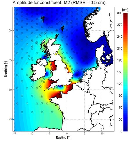
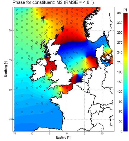


8 Calibration: DCSMv6 (against satelite altimeter data) M2 Amplitude M2 Phase


9 DCSMv6 calibration OpenDA-DUD experiment setup and parameters Parameters related to prescription at the open boundary excluded from the optimization problem Tidal error introduced during the tidal propagation Reduction of uncertainty in bottom friction coefficient and bathymetry Control parameters defined between measurement locations Multiple optimization runs, with increasing length and number of parameters Long period to account for non-stationarity of tidal amplitudes and phases Large area to account for spatial interaction Final experiment had 200 control parameters, 12 months, ~100 observations locations

10 Model calibration Calibration and validation using tide gauge data at >120 locations Green dots: radar altimeter cross-over locations Red dots: in-situ tide-gauge locations
11 Results: Dutch coastal tide gauge stations Goodness-of-Fit (in cm) for 13 Dutch coastal stations, 2007 (tide) (surge) (total) (high water) (low water) DCSMv DCSMv6 (Regular mesh) % -23% -47% -42% -35% (harmonic analysis with 118 constituents)


12 DCSMv6 - results Results for tide, surge and total water level Red: Black: Blue: Measurement Computation Residual
13 DCSMv6 Hoek van Holland; HIRLAM vs ECMWF Hirlam ECMWF 14 september 2015
14 DCSMv6 (Dutch coast) (tide) (surge) (total) (high water) (low water) DCSMv6-Hirlam DCSMv6-ECMWF skew surges from to all skew surges 1% highest skew surges 0.2% highest skew surges Model bias bias bias DCSMv6-Hirlam DCSMv6-ECMWF % 14 september 2015
15 VERSION with Flexible Mesh

 # net links from 1,700,000 to 752,000 (factor 2.")
16 Local grid coarsening 400 m contour 100 m contour Red: Blue: Green: original grid size 2x coarsened 4x coarsened # net nodes from 860,000 to 358,000 (factor 2.5) # net links from 1,700,000 to 752,000 (factor 2.25)
17 Grid optimization Numerical time step Numerical accuracy is determined by the (wave) Courant number As this is proportional to the square root of the depth, with a uniform grid size, the deepest cells are limiting the computational time step. Further increase in computational speed by increasing maximum allowed time step from 2 to 3 minutes With the upgraded flexible resolution grid and increased time step, the model is roughly speaking 3-4 times faster (on one core) Goodness-of-Fit (in cm) - 13 Dutch coastal stations - entire year of 2007) (tide) (surge) (total) Regular mesh Delft3D FM Delft3D FM (coarsened) November 4, 2014
Storm surge forecasting and other Met Office ocean modelling
 Storm surge forecasting and other Met Office ocean modelling EMODnet stakeholder meeting Clare O Neill + many others Outline Ocean modelling at the Met Office Storm surge forecasting Current operational
Probability forecasts for water levels at the coast of The Netherlands
 from Newsletter Number 114 Winter 7/8 METEOROLOGY Probability forecasts for water levels at the coast of The Netherlands doi:1.1957/gpsn56sc This article appeared in the Meteorology section of ECMWF Newsletter
Earth Observation in coastal zone MetOcean design criteria
 ESA Oil & Gas Workshop 2010 Earth Observation in coastal zone MetOcean design criteria Cees de Valk BMT ARGOSS Wind, wave and current design criteria geophysical process uncertainty modelling assumptions
Post flood analysis. Demands of the Storm Surge Warning Service (SVSD) of the Netherlands. Annette Zijderveld/ Martin Verlaan
 of the Netherlands. Annette Zijderveld/ Martin Verlaan") Post flood analysis Demands of the Storm Surge Warning Service (SVSD) of the Netherlands Annette Zijderveld/ Martin Verlaan Objective Bringing in coastal issues to the FEWS user days (second attempt) Demonstrating
Post flood analysis Demands of the Storm Surge Warning Service (SVSD) of the Netherlands Annette Zijderveld/ Martin Verlaan Objective Bringing in coastal issues to the FEWS user days (second attempt) Demonstrating
Coastal forecasting and training in the Netherlands
 Coastal forecasting and training in the Netherlands Annette Zijderveld, Firmijn Zijl, Martin Verlaan, Saskia Vermeer, Micheline Hounjet, Casper Hartefeld Outline Coastal forecasting Operational forecasters
Adapting NEMO for use as the UK operational storm surge forecasting model
 Adapting NEMO for use as the UK operational storm surge forecasting model Rachel Furner 1, Jane Williams 2, Kevin Horsburgh 2, Andy Saulter 1 1; Met Office 2; NOC Table of Contents Existing CS3 model Developments
Development of Operational Storm Surge Guidance to Support Total Water Predictions
 Development of Operational Storm Surge Guidance to Support Total Water Predictions J. Feyen 1, S. Vinogradov 1,2, T. Asher 3, J. Halgren 4, Y. Funakoshi 1,5 1. NOAA/NOS//Development Laboratory 2. ERT,
New Storm Surge Catastrophe Model for Great Britain and Beyond
 New Storm Surge Catastrophe Model for Great Britain and Beyond Richard Yablonsky, Mohammad Keshtpoor, and Austen Blair 33 rd Conference on Hurricanes and Tropical Meteorology American Meteorological Society
Assessing Storm Tide Hazard for the North-West Coast of Australia using an Integrated High-Resolution Model System
 Assessing Storm Tide Hazard for the North-West Coast of Australia using an Integrated High-Resolution Model System J. Churchill, D. Taylor, J. Burston, J. Dent September 14, 2017, Presenter Jim Churchill
Modeling New York in D-Flow FM
 Modeling New York in D-Flow FM Delft, 30 th of October 2013 Internship Tuinhof, T.J. (Taco) August - October 2013 Supervisors: Sander Post (Royal HaskoningDHV) Maarten van Ormondt (Deltares) Contents Introduction...
Effect of coastal resolution on global estimates of tidal energy dissipation
 Effect of coastal resolution on global estimates of tidal energy dissipation Maialen Irazoqui Apecechea, Martin Verlaan Contents The GTSMv2.0 model Characteristics Major developments Applications Coastal
The MSC Beaufort Wind and Wave Reanalysis
 The MSC Beaufort Wind and Wave Reanalysis Val Swail Environment Canada Vincent Cardone, Brian Callahan, Mike Ferguson, Dan Gummer and Andrew Cox Oceanweather Inc. Cos Cob, CT, USA Introduction: History
Development of JMA storm surge model
 2 nd JCOMM Scientific and Technical Symposium on Storm Surges 8-13 November 2015, Key West, Florida, USA Development of JMA storm surge model Hiroshi HASEGAWA (h_hasegawa@met.kishou.go.jp) Office of Marine
Chapter 27. Shelf sea modelling Test case bohai
 Chapter 27 Shelf sea modelling 27.1 Test case bohai The aim of this test case is to illustrate the use of COHERENS for tidal prediction studies, to show how an harmonic analysis can be performed and how
DATA ASSIMILATION STUDY USING THE DUTCH CONTINENTAL SHELF MODEL WITH FULL MEASUREMENT
 DATA ASSIMILATION STUDY USING THE DUTCH CONTINENTAL SHELF MODEL WITH FULL MEASUREMENT JULIUS H. SUMIHAR AND MARTIN VERLAAN,2 Faculty of Electrical Engineering, Mathematics and Computer Science, Department
DATA ASSIMILATION FOR FLOOD FORECASTING
 DATA ASSIMILATION FOR FLOOD FORECASTING Arnold Heemin Delft University of Technology 09/16/14 1 Data assimilation is the incorporation of measurement into a numerical model to improve the model results
MODELLING CATASTROPHIC COASTAL FLOOD RISKS AROUND THE WORLD
 MODELLING CATASTROPHIC COASTAL FLOOD RISKS AROUND THE WORLD Nicola Howe Christopher Thomas Copyright 2016 Risk Management Solutions, Inc. All Rights Reserved. June 27, 2016 1 OUTLINE MOTIVATION What we
New developments in data assimilation in MIKE 21/3 FM Assimilation of along-track altimetry data with correlated measurement errors
 New developments in data assimilation in MIKE 21/3 FM Assimilation of along-track altimetry data with correlated measurement errors EnKF Workshop 2016-06-20 Jesper Sandvig Mariegaard Henrik Andersson DHI
1.2 DEVELOPMENT OF THE NWS PROBABILISTIC EXTRA-TROPICAL STORM SURGE MODEL AND POST PROCESSING METHODOLOGY
 1.2 DEVELOPMENT OF THE NWS PROBABILISTIC EXTRA-TROPICAL STORM SURGE MODEL AND POST PROCESSING METHODOLOGY Huiqing Liu 1 and Arthur Taylor 2* 1. Ace Info Solutions, Reston, VA 2. NOAA / NWS / Science and
FOWPI Metocean Workshop Modelling, Design Parameters and Weather Windows
 FOWPI Metocean Workshop Modelling, Design Parameters and Weather Windows Jesper Skourup, Chief Specialist, COWI 1 The Project is funded by The European Union Agenda 1. Metocean Data Requirements 2. Site
Coupling of Wave and Hydrodynamic Models for Predicting Coastal Inundation: A case study in Jakarta and Semarang
 Coupling of Wave and Hydrodynamic Models for Predicting Coastal Inundation: A case study in Jakarta and Semarang http://peta-maritim.bmkg.go.id/cifdp/maps Nelly Florida Riama,Andri Ramdhani, Andi Eka Sakya,,
networks from ISPRA GABRIELE NARDONE, MAURO BENCIVENGA, GIOVANNI ARENA
 The Italian observational networks from ISPRA retemareografica@isprambiente.itit reteondametrica@isprambiente.it GABRIELE NARDONE, MAURO BENCIVENGA, GIOVANNI ARENA ISPRA - RMN Italian Tide Gauge Network
Improving the initialisation of our operational shelf-seas models
 Improving the initialisation of our operational shelf-seas models Robert King James While, Matt Martin, Dan Lean, Jennie Waters, Enda O Dea, Jenny Graham NPOP May 2018 Contents 1. Recent history developments
An Ensemble based Reliable Storm Surge Forecasting for Gulf of Mexico
 An Ensemble based Reliable Storm Surge Forecasting for Gulf of Mexico Umer Altaf Delft University of Technology, Delft ICES, University of Texas at Austin, USA KAUST, Saudi Arabia JONSMOD 2012, Ifremer,
EFFECTIVE TROPICAL CYCLONE WARNING IN BANGLADESH
 Country Report of Bangladesh On EFFECTIVE TROPICAL CYCLONE WARNING IN BANGLADESH Presented At JMA/WMO WORKSHOP ON EFFECTIVE TROPICAL CYCLONE WARNING IN SOUTHEAST ASIA Tokyo, Japan,11-14 March 2014 By Sayeed
Tidal stream atlases Reprinted by PC Maritime with kind permission of Proudman Laboratory
 The generation of UK tidal stream atlases from regularly gridded hydrodynamic modelled data by Colin Bell and Lisa Carlin Proudman Oceanographic Laboratory http://www.pol.ac.uk http://www.pcmaritime.co.uk
Hindcast Arabian Gulf
 Hindcast Arabian Gulf Image of isobars of atmospheric pressure and hindcast wind- and wave field over the Arabian Gulf during a storm in January 1993. Detailed wave studies are supported by nesting of
The impact of combined assimilation of altimeters data and wave spectra from S-1A and 1B in the operational model MFWAM
 The impact of combined assimilation of altimeters data and wave spectra from S-1A and 1B in the operational model MFWAM Lotfi Aouf and Alice Dalphinet Météo-France, Département Marine et Oceanographie
THE OPEN UNIVERSITY OF SRI LANKA
 THE OPEN UNIVERSITY OF SRI LANKA Extended Abstracts Open University Research Sessions (OURS 2017) 16 th & 17 th November, 2017 The Open University of Sri Lanka - 2017 All rights reserved. No part of this
Coastal Inundation Forecasting and Community Response in Bangladesh
 WMO Coastal Inundation Forecasting and Community Response in Bangladesh Bapon (SHM) Fakhruddin Nadao Kohno 12 November 2015 System Design for Coastal Inundation Forecasting CIFDP-PSG-5, 14-16 May 2014,
Process and resolution impacts on UK coastal wave predictions from operational global-regional wave models
 Process and resolution impacts on UK coastal wave predictions from operational global-regional wave models Andy Saulter, Jian-Guo Li, Chris Bunney and Tamzin Palmer Met Office Email: andrew.saulter@metoffice.gov.uk
Sea Level Variability in the East Coast of Male, Maldives
 Sea Level Variability in the East Coast of Male, Maldives K.W. Indika 1 *, E.M.S. Wijerathne 2, G. W. A. R. Fernando 3, S.S.L.Hettiarachchi 4 1 National Aquatics Resources Research and Development Agency,
Application and verification of ECMWF products in Norway 2008
 Application and verification of ECMWF products in Norway 2008 The Norwegian Meteorological Institute 1. Summary of major highlights The ECMWF products are widely used by forecasters to make forecasts for
HARMONIE at KNMI and future work HIRLAM-ALADIN meeting April 2013 Reyjavik, Iceland
 HARMONIE at KNMI and future work HIRLAM-ALADIN meeting 15-18 April 2013 Reyjavik, Iceland Jan Barkmeijer KNMI OUTLINE Harmonie suites at KNMI Experiences with new observation sets Projects with Harmonie
Performance of the Nortek Aquadopp Z-Cell Profiler on a NOAA Surface Buoy
 Performance of the Nortek Aquadopp Z-Cell Profiler on a NOAA Surface Buoy Eric Siegel NortekUSA Annapolis, USA Rodney Riley & Karen Grissom NOAA National Data Buoy Center Stennis Space Center, USA Abstract-Observations
Ocean self-attraction and loading (SAL) and internal tides dissipation implementation within an unstructured global tide-surge model
 and internal tides dissipation implementation within an unstructured global tide-surge model") Ocean self-attraction and loading (SAL) and internal tides dissipation implementation within an unstructured global tide-surge model Maialen Irazoqui Apecechea, Martin Verlaan Contents Context: BASE Platform
Ocean self-attraction and loading (SAL) and internal tides dissipation implementation within an unstructured global tide-surge model Maialen Irazoqui Apecechea, Martin Verlaan Contents Context: BASE Platform
PREDICTION OF OIL SPILL TRAJECTORY WITH THE MMD-JMA OIL SPILL MODEL
 PREDICTION OF OIL SPILL TRAJECTORY WITH THE MMD-JMA OIL SPILL MODEL Project Background Information MUHAMMAD HELMI ABDULLAH MALAYSIAN METEOROLOGICAL DEPARTMENT(MMD) MINISTRY OF SCIENCE, TECHNOLOGY AND INNOVATION
NOOS EuroGOOS Annual meeting
 NOOS EuroGOOS Annual meeting 22.-23.11.2012 Hamburg Henning Wehde NOOS Chair NOOS objectives Co-ordinate, improve and harmonize the development of operational marine data and information services Provide
Internal Tides in the Bab el Mandab Strait. Ewa Jarosz and Cheryl Ann Blain Naval Research Laboratory, Stennis Space Center, MS
 Internal Tides in the Bab el Mandab Strait Ewa Jarosz and Cheryl Ann Blain Naval Research Laboratory, Stennis Space Center, MS Project Objectives Numerical simulation of tides and exchange flow in the
USING MIKE TO MODEL COASTAL CATASTROPHE RISK
 USING MIKE TO MODEL COASTAL CATASTROPHE RISK Nicola Howe, Christopher Thomas, Joss Matthewman, John Maskell* 1 SUMMARY About RMS Who are we and what do we do? How do we use MIKE in our workflow? Case study:
ANALYSIS OF CURRENT PATTERNS IN COASTAL AREAS USING X-BAND RADAR IMAGES
 ANALYSIS OF CURRENT PATTERNS IN COASTAL AREAS USING X-BAND RADAR IMAGES Cilia Swinkels 1, Herman Peters 2 and Jos van Heesen 3 The Seadarq software from Nortek is designed to derive wave, water depth and
The Improvement of JMA Operational Wave Models
 The Improvement of JMA Operational Wave Models Toshiharu Tauchi Nadao Kohno * Mika Kimura Japan Meteorological Agency * (also) Meteorological Research Institute, JMA 10 th International Workshop on Wave
Storm surge modeling at RSMC La Réunion. Cliquez pour modifier le style des sous-titres du masque
 Storm surge modeling at RSMC La Réunion Cliquez pour modifier le style du titre Cliquez pour modifier le style des sous-titres du masque 6th session training course of tropical cyclones (28 oct. 5 nov.
Inter comparison of wave height observations from buoy and altimeter with numerical prediction
 Indian Journal of Geo-Marine Sciences Vol. 43(7), July 2014, pp. 1347-1351 Inter comparison of wave height observations from buoy and altimeter with numerical prediction S. A. Sannasiraj 1*, M. Kalyani
POLCOMS Metadata for the ARCoES project Keywords: POLCOMS, WAM, residual circulation, waves, Liverpool Bay, UK shelf
 POLCOMS Metadata for the ARCoES project Keywords: POLCOMS, WAM, residual circulation, waves, Liverpool Bay, UK shelf POLCOMS is the Proudman Oceanographic Laboratory Coastal Ocean Modelling System. It
TIDE GAUGE AND SATELLITE ALTIMETRY INTEGRATION FOR STORM SURGE PREDICTION
 TIDE GAUGE AND SATELLITE ALTIMETRY INTEGRATION FOR STORM SURGE PREDICTION Ole B. Andersen 1, Y. Cheng 1, X. Deng 2, M. Steward 2 and Z. Gharinerat 2 (1) DTU Space, Elektrovej bldg. 328 Lyngny, Denmark
Air-Sea Interaction in Extreme Weather Conditions
 Air-Sea Interaction in Extreme Weather Conditions Hans (J.W.) de Vries, Niels Zweers,, Vladimir Makin, Vladimir Kudryavtsev, and Gerrit Burgers, KNMI, De Bilt, NL Meteogroup, Wageningen, NL NIERSC, St.
CHAPTER 27 AN EVALUATION OF TWO WAVE FORECAST MODELS FOR THE SOUTH AFRICAN REGION. by M. Rossouw 1, D. Phelp 1
 CHAPTER 27 AN EVALUATION OF TWO WAVE FORECAST MODELS FOR THE SOUTH AFRICAN REGION by M. Rossouw 1, D. Phelp 1 ABSTRACT The forecasting of wave conditions in the oceans off Southern Africa is important
Advances in Coastal Inundation Simulation Using Unstructured-Grid Coastal Ocean Models
 Advances in Coastal Inundation Simulation Using Unstructured-Grid Coastal Ocean Models Bob Beardsley (WHOI) Changsheng Chen (UMass-Dartmouth) Bob Weisberg (U. South Florida) Joannes Westerink (U. Notre
GSA DATA REPOSITORY
 GSA DATA REPOSITORY 2009206 Miner et al. Supplemental Material Bathymetric Survey Methods The bathymetric data for the area were gathered using a single-beam bathymetric survey rig mounted aboard a 21-foot
Application and verification of the ECMWF products Report 2007
 Application and verification of the ECMWF products Report 2007 National Meteorological Administration Romania 1. Summary of major highlights The medium range forecast activity within the National Meteorological
Final VRF grids Date: Aug 25, 2011 Author: R. Forsberg, G. Strykowski, O. Andersen
 Final VRF grids Date: Aug 25, 2011 Author: R. Forsberg, G. Strykowski, O. Andersen www.blast-project.eu 1 Authors Name Organisation Rene Forsberg National Space Institute, DTU G. Strykowski National Space
EWGLAM/SRNWP National presentation from DMI
 EWGLAM/SRNWP 2013 National presentation from DMI Development of operational Harmonie at DMI Since Jan 2013 DMI updated HARMONIE-Denmark suite to CY37h1 with a 3h-RUC cycling and 57h forecast, 8 times a
Morphological Modeling of Inlets and Adjacent Shorelines on Engineering Timescales
 CB&I Morphological Modeling of Inlets and Adjacent Shorelines on Engineering Timescales Challenges and Model Improvements based on Recent Studies Dobrochinski, J.P.H.; Benedet, L.; Signorin, M.; Pierro,
The Field Research Facility, Duck, NC Warming Ocean Observations and Forecast of Effects
 The Field Research Facility, Duck, NC Warming Ocean Observations and Forecast of Effects A potential consequence of a warming ocean is more frequent and more intense wind events (Hurricanes & Typhoons)
WERA Ocean Radar Capability of Real-Time Tsunami Detection
 WERA Ocean Radar Capability of Real-Time Tsunami Detection Dr. Anna Dzvonkovskaya Helzel Messtechnik GmbH Kaltenkirchen, GERMANY e-mail: dzvonkovskaya@helzel.com member of and Worldwide WERA HF Ocean Radar
(JONSMOD 2008 Paper) An intercomparison of tidal solutions computed. with a range of unstructured grid models of the. Irish and Celtic Sea Regions
 An intercomparison of tidal solutions computed. with a range of unstructured grid models of the. Irish and Celtic Sea Regions") F: TLQUODVR1 Nov 7th 2008 Revised July 2009 Final Revision Aug 2009 (JONSMOD 2008 Paper) An intercomparison of tidal solutions computed with a range of unstructured grid models of the Irish and Celtic
F: TLQUODVR1 Nov 7th 2008 Revised July 2009 Final Revision Aug 2009 (JONSMOD 2008 Paper) An intercomparison of tidal solutions computed with a range of unstructured grid models of the Irish and Celtic
SLOSH New Orleans Basin 2012 Update
 SLOSH New Orleans Basin 2012 Update Michael Koziara Science and Operations Officer National Weather Service Slidell, LA The Basics What is storm surge? What is SLOSH? Details Assumptions Inundation = Storm
THC-T-2013 Conference & Exhibition
 Modeling of Shutter Coastal Protection against Storm Surge for Galveston Bay C. Vipulanandan, Ph.D., P.E., Y. Jeannot Ahossin Guezo and and B. Basirat Texas Hurricane Center for Innovative Technology (THC-IT)
SPECIAL PROJECT PROGRESS REPORT
 SPECIAL PROJECT PROGRESS REPORT Progress Reports should be 2 to 10 pages in length, depending on importance of the project. All the following mandatory information needs to be provided. Reporting year
Indian Ocean Forecast System (INDOFOS) Abhisek Chatterjee
 Abhisek Chatterjee") Indian Ocean Forecast System (INDOFOS) Abhisek Chatterjee Earth System Sciences Organisation (ESSO) Indian National Centre for Ocean Information Services (INCOIS) Ministry of Earth Sciences, Government
Indian Ocean Forecast System (INDOFOS) Abhisek Chatterjee Earth System Sciences Organisation (ESSO) Indian National Centre for Ocean Information Services (INCOIS) Ministry of Earth Sciences, Government
Recent improvements on the wave forecasting system of Meteo-France: modeling and assimilation aspects
 Recent improvements on the wave forecasting system of Meteo-France: modeling and assimilation aspects L. Aouf and J-M. Lefèvre Division Marine et Océanographie, Météo-France 13 th International workshop
International Conference Analysis and Management of Changing Risks for Natural Hazards November 2014 l Padua, Italy
 Abstract code: AO6 Hindcast of extreme hydro-meteorological events along the Bulgarian Black Sea coast Anna Kortcheva, Vasko Galabov, Marieta Dimitrova, Andrey Bogatchev National Institute of Meteorology
Forcing ocean model with atmospheric model outputs to simulate storm surge in the Bangladesh coast
 Forcing ocean model with atmospheric model outputs to simulate storm surge in the Bangladesh coast Nabir Mamnun 1, 2, Lucy Brechino 3, Md. Rashed-Un-Nabi 2 1. Nansen-Bangladesh International Centre for
HARMONIC CONSTANTS Product Specification
 HARMONIC CONSTANTS Product Specification Edition 1.0 Edition 1 November 2006 1 Contents 1. Introduction 1.1 General 1.2 Definitions 2. General Information 2.1 Observation of the Tide 2.2 Harmonic Analysis
South San Francisco Bay Shoreline Studies for EIA 11 with Project Conditions
 South San Francisco Bay Shoreline Studies for EIA 11 with Project Conditions U.S. Army Corps of Engineers San Francisco District Ms. Lisa Andes Mr. Craig Conner Dr. Frank Wu Dr. Jen-Men Lo Dr. Michael
Upgrades to the Operational Sea State Forecast System
 NMOC Operations Bulletin No. 53 Upgrades to the Operational Sea State Forecast System Introduction 25 August 2000 The WAM wave model (WAMDI, 1988, Komen et al., 1994) has been the operational sea state
Storm surge and wave simulations in the Gulf of Mexico using a consistent drag relation for atmospheric and storm surge models
 doi:10.5194/nhess-12-2399-2012 Author(s) 2012. CC Attribution 3.0 License. Natural Hazards and Earth System Sciences Storm surge and wave simulations in the Gulf of Mexico using a consistent drag relation
Near-coastal satellite altimetry: Sea surface height variability in the North Sea Baltic Sea area
 Near-coastal satellite altimetry: Sea surface height variability in the North Sea Baltic Sea area K. S. Madsen 1,2, J. L. Høyer 2, and C. C. Tscherning 1 An edited version of this paper was published by
Robust Ensemble Filtering With Improved Storm Surge Forecasting
 Robust Ensemble Filtering With Improved Storm Surge Forecasting U. Altaf, T. Buttler, X. Luo, C. Dawson, T. Mao, I.Hoteit Meteo France, Toulouse, Nov 13, 2012 Project Ensemble data assimilation for storm
National Oceanography Centre. Research & Consultancy Report No. 38
 National Oceanography Centre Research & Consultancy Report No. 38 Evaluation and comparison of the operational Bristol Channel Model storm surge suite J A Williams & K J Horsburgh 2013 Revised September
Data assimilation in coastal ocean modelling and forecasting. Application aspects - beyond the user manual
 Data assimilation in coastal ocean modelling and forecasting Application aspects - beyond the user manual Herman Gerritsen, Martin Verlaan, Julius Sumihar, Firmijn Zijl thanks to various Deltares and SDWA
Improving global coastal inundation forecasting WMO Panel, UR2014, London, 2 July 2014
 Improving global coastal inundation forecasting WMO Panel, UR2014, London, 2 July 2014 Cyclone Sidr, November 2007 Hurricane Katrina, 2005 Prof. Kevin Horsburgh Head of marine physics, UK National Oceanography
Integrated Hydrodynamic Modeling System
 Integrated Hydrodynamic Modeling System Applied Science Associates, Inc. 70 Dean Knauss Drive Narragansett, RI USA 02882 www.asascience.com support@asascience.com 1 Introduction HYDROMAP is a globally
Savannah Harbor Expansion Project
 Savannah Harbor Expansion Project Evaluation of Hurricane Surge Impacts with Proposed Mitigation Plan December 2007 Introduction This report summarizes the results of hurricane surge impacts with implementation
Evaluation of the Performance of the South Coast Model from September August 2006
 No. 182 Evaluation of the Performance of the South Coast Model from September 2005- August 2006 Jane A. Williams, Kevin J. Horsburgh, David L. Blackman January 2007 POL Internal Document No. 182 Evaluation
Hurricane IRMA Shom s actions & lessons learned
 Hurricane IRMA Shom s actions & lessons learned MACHC 18 Varadero, Cuba 30.11.17 TIDE OBSERVATION FRENCH PERMANENT SEA LEVEL OBSERVATION NETWORK IN THE CARIBBEAN S t Martin Deshaies La Désirade Point à
Development of a coastal monitoring and forecasting system at MRI/JMA
 COSS-TT and ARCOM Development of a coastal monitoring and forecasting system at MRI/JMA N. USUI, Y. Fujii, K, Sakamoto, H. Tsujino, T. Kuragano & Masa KAMACHI Meteorological Research Institute, Japan Sept
5 Simulation of storm surges in the Bay of Bengal
 Chapter 5 5 Simulation of storm surges in the Bay of Bengal 5.1 Introduction As a first step towards increasing the accuracy of storm surge simulation, a 2D model was developed to simulate the tides in
STORM SURGE SIMULATION IN NAGASAKI DURING THE PASSAGE OF 2012 TYPHOON SANBA
 STORM SURGE SIMULATION IN NAGASAKI DURING THE PASSAGE OF 2012 TYPHOON SANBA D. P. C. Laknath 1, Kazunori Ito 1, Takahide Honda 1 and Tomoyuki Takabatake 1 As a result of global warming effect, storm surges
THERMOHALINE OCEAN CIRCULATION IN MAKRAN COASTS-IRAN by
 THERMOHALINE OCEAN CIRCULATION IN MAKRAN COASTS-IRAN by Mohammad Bagheri 1, M. Reza Allahyar 1, Mehdi Shafieefar 2, M. Hosein Nemati 1, Ali Ghasemi 2, Ahmad Rezaei 2 ABSTRACT Ocean currents are generated
Simulation of storm surge and overland flows using geographical information system applications
 Coastal Processes 97 Simulation of storm surge and overland flows using geographical information system applications S. Aliabadi, M. Akbar & R. Patel Northrop Grumman Center for High Performance Computing
P2.57 Cyclone Yasi Storm Surge in Australia Implications for Catastrophe Modeling
 P2.57 Cyclone Yasi Storm Surge in Australia Implications for Catastrophe Modeling Kevin A. Hill*, Peter Sousounis, and Jason Butke AIR Worldwide Corporation, Boston, Massachusetts 1. INTRODUCTION Storm
SPATIAL CHARACTERISTICS OF THE SURFACE CIRCULATION AND WAVE CLIMATE USING HIGH-FREQUENCY RADAR
 SPATIAL CHARACTERISTICS OF THE SURFACE CIRCULATION AND WAVE CLIMATE USING HIGH-FREQUENCY RADAR Apisit Kongprom,Siriluk Prukpitikul, Varatip Buakaew, Watchara Kesdech, and Teerawat Suwanlertcharoen Geo-Informatics
European Geosciences Union General Assembly Vienna, Austria 27 April - 02 May 2014
 European Geosciences Union General Assembly Vienna, Austria 27 April - 02 May 2014 Projecting the Current & Future Impact of Storm Surges on Coastal Flood Extent at Pigeon Point, South-West Tobago, through
WIND EFFECTS ON CHEMICAL SPILL IN ST ANDREW BAY SYSTEM
 WIND EFFECTS ON CHEMICAL SPILL IN ST ANDREW BAY SYSTEM PETER C. CHU, PATRICE PAULY Naval Postgraduate School, Monterey, CA93943 STEVEN D. HAEGER Naval Oceanographic Office, Stennis Space Center MATHEW
Earth Observation & forecasting Storm Surges in the North Western Pacific. Mr. Nadao Kohno Japan Meteorological Agency
 Earth Observation & forecasting Storm Surges in the North Western Pacific Mr. Nadao Kohno Japan Meteorological Agency Lesson Outline Introduction JMA s responsibility and work as a RSMC, Tokyo Typhoon
2014/2/25. Earth Observation & forecasting Storm Surges in the North Western Pacific. Lesson Outline. RSMC Tokyo Typhoon Center.
 Earth Observation & forecasting Storm Surges in the North Western Pacific Mr. Nadao Kohno Japan Meteorological Agency Lesson Outline Introduction JMA s responsibility and work as a RSMC, Tokyo Typhoon
Coastal Flood Risk Study Project for East Coast Central Florida Study Area
 Coastal Flood Risk Study Project for East Coast Central Florida Study Area St Lucie County, Florida Flood Risk Review Meeting March 28, 2017 Introductions Risk MAP Project Team FEMA Region IV BakerAECOM,
Relative sea level change across the Forth Estuary. Dr. Victoria Powell University of Chester
 Relative sea level change across the Forth Estuary Dr. Victoria Powell University of Chester v.powell@chester.ac.uk Forth Estuary Forum Annual Conference, 17 th November 2016 Sea Level Change Global sea
Using satellite altimetry and tide gauges for storm surge warning
 doi:10.5194/piahs-365-28-2015 28 Complex Interfaces Under Change: Sea River Groundwater Lake Proceedings of HP2/HP3, IAHS-IAPSO-IASPEI Assembly, Gothenburg, Sweden, July 2013 (IAHS Publ. 365, 2014). Using
Analysis of Physical Oceanographic Data from Bonne Bay, September 2002 September 2004
 Physics and Physical Oceanography Data Report -1 Analysis of Physical Oceanographic Data from Bonne Bay, September September Clark Richards and Brad deyoung Nov. 9 Department of Physics and Physical Oceanography
ASCAT B OCEAN CALIBRATION AND WIND PRODUCT RESULTS
 ASCAT B OCEAN CALIBRATION AND WIND PRODUCT RESULTS Jeroen Verspeek 1, Ad Stoffelen 1, Anton Verhoef 1, Marcos Portabella 2, Jur Vogelzang 1 1 KNMI, Royal Netherlands Meteorological Institute, De Bilt,
Validation Report: WP5000 Regional tidal correction (Noveltis)
") Consortium Members ESA Cryosat Plus for Oceans Validation Report: WP5000 Regional tidal correction (Noveltis) Reference: Nomenclature: CLS-DOS-NT-14-083 CP4O-WP5000-VR-03 Issue: 2. 0 Date: Jun. 20, 14
Consortium Members ESA Cryosat Plus for Oceans Validation Report: WP5000 Regional tidal correction (Noveltis) Reference: Nomenclature: CLS-DOS-NT-14-083 CP4O-WP5000-VR-03 Issue: 2. 0 Date: Jun. 20, 14
3.6 EFFECTS OF WINDS, TIDES, AND STORM SURGES ON OCEAN SURFACE WAVES IN THE JAPAN/EAST SEA
 3.6 EFFECTS OF WINDS, TIDES, AND STORM SURGES ON OCEAN SURFACE WAVES IN THE JAPAN/EAST SEA Wei Zhao 1, Shuyi S. Chen 1 *, Cheryl Ann Blain 2, Jiwei Tian 3 1 MPO/RSMAS, University of Miami, Miami, FL 33149-1098,
Geophysical Correction Application in Level 2 CryoSat Data Products
 ESRIN-EOP-GQ / IDEAS IDEAS-VEG-IPF-MEM-1288 Version 2.0 29 July 2014 Geophysical Correction Application in Level 2 CryoSat Data Products TABLE OF CONTENTS 1 INTRODUCTION... 3 1.1 Purpose and Scope... 3
The Application of POM to the Operational Tidal Forecast for the Sea around Taiwan
 The Application of POM to the Operational Tidal Forecast for the Sea around Taiwan Shan-Pei YEH 1 Hwa CHIEN Sen JAN 3 and Chia Chuen KAO 4 1 Coastal Ocean Monitoring Center, National Cheng Kung University,
Evaporation Duct Height Climatology for Norwegian Waters Using Hindcast Data
 Evaporation Duct Height Climatology for Norwegian Waters Using Hindcast Data Petter Østenstad Norwegian Defence Research Establishment (FFI) Horten NORWAY Petter.Ostenstad@ffi.no Marthe Marie Meltzer Norwegian
Arun Platform Tide Gauge
 Arun Platform Tide Gauge Location OS: 506423E 97778N WGS84: Latitude: 50 46 11.39042"N Longitude: 00 29 31.73595"W Instrument Valeport 730 (Druck Pressure Transducer) TGBM Benchmarks Benchmark Description
UNDERSTANDING STORM TIDES
 UNDERSTANDING STORM TIDES Run from the water, hide from the wind.. CATEGORY CATEGORY CATEGORY CATEGORY CATEGORY 1 2 3 4 5 WIND 74-95 mph 64-82 knots 96-110 mph 83-95 knots 111-130 mph 96-113 knots 131-155