Sea level changes around Thailand
|
|
|
- Cassandra Lloyd
- 5 years ago
- Views:
Transcription


1 Final symposium 27 May Bangkok, Thailand Sea level changes around Thailand Marc Naeije
2 Contents GEO2TECDI- SONG: measuring sea level around Thailand Concept of satellite altimetry Concept of tide gauges Altimetry results around Thailand: periodic sea level and trends Sea level rise in the Gulf of Thailand Vertical land motions: altimetry minus tide gauges Conclusions Radar altimeter data system RADS Cryosat- 2 opportunities for the Gulf of Thailand 2
3 GEO2TECDI- SONG: measuring sea level around Thailand In the Thailand- EC GEO2TECDI- SONG projects we investigate the vertical land motion in Thailand and sea level change in the Gulf of Thailand and Andaman Sea. An important focus is on Bangkok which is situated in a river delta and average height is close to sea level is subsiding due to ground water extraction is experiencing post- seismic motion due to nearby mega- thrust Earthquakes suffers from rising sea levels due to global climate change Combined with excessive rainfall this poses a serious threat to Thai society and economy, and therefore we have to monitor the sea level around Thailand, for instance with satellite altimetry and tide gauges. 3

4 Altimetry: N + S = r H - (corrections) r = satellite height H = altimetric distance N = geoid S = dynamic topography r H S N Radar pulse reflecting at the sea surface. 4


5 Altimetry continued Averaging many pulses together reduces noise and results in typical waveform that can be analysed. The position of the rising edge centre corresponds to the (average) distance of the sea surface. The slope and the amplitude of the echo are related, respectively, to wave height and to wind speed. Approaching the coast the waveform is corrupted by land in the radar footprint (red curve). 5


6 Altimetry: what it measures 6


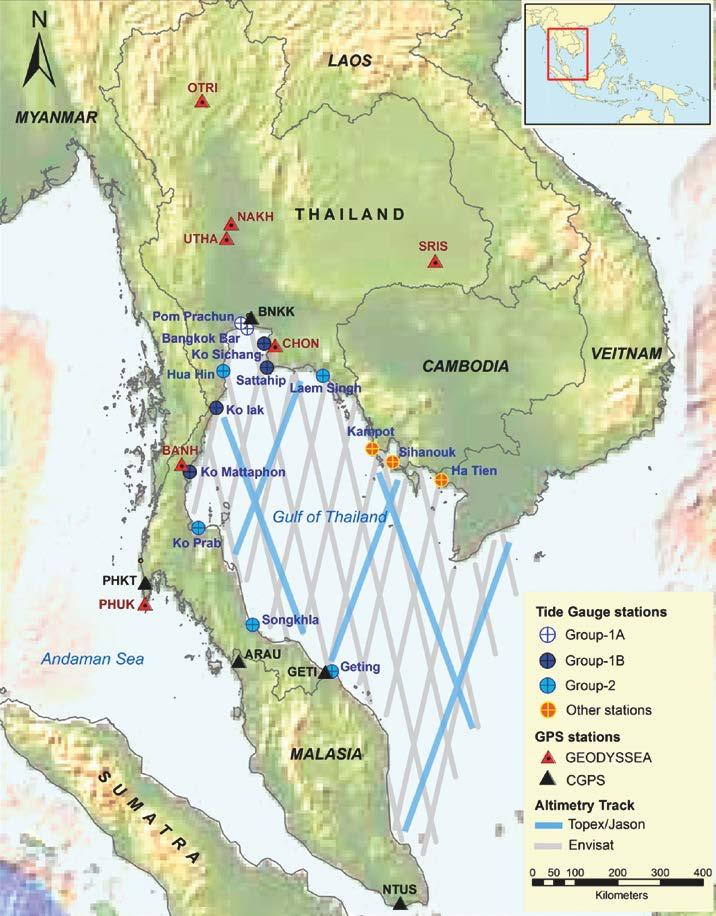
7 Tide gauges Measure sea level w.r.t. geodetic benchmark Most common is a float operated in a pipe or stilling well Move vertically with the land due to post- glacial rebound, tectonic uplift, and/or subsidence Often tied to GPS recei- ver for absolute datum No global/dense data; +/- 20cm sea level rise over last century CCAR, Univ. of Colorado Tide gauge station at Hua Hin 7


8 Processed region 8

9 Regional sea level dynamics A simultaneous fit of linear trend, annual, semi- annual cycle and a bias, subjected to IRLS has been applied to monthly- averaged altimeter meshes (animation shown). In a direct comparison with tide gauge and GPS data we have to take into account the discontinuity in land motion due to the 2004 Sumatra Earthquake. Though the sea level trend over the medium length period seems significantly affected by the lunar nodal tide effect (18.6 year cycle), the effect in tide gauge data is the same and cancels out when differenced. 9


10 Sea level annual cycle 10


11 Sea level semi- annual cycle 11


12 Sea level trend and error 12


13 Sea level rise in the Gulf of Thailand 13
.")
14 Altimetry and tide gauges Direct comparison between tide gauge monthly- average time series and those from altimetry from (prior to 2004 Sumatra Earthquake). An arbitrary bias is removed. Solid circles have final weight < 0.5 and crosses get zero weight (outliers). The given numbers give distance to TOPEX- class track, RMSE, correlation, and percentage valid observations. 14
15 Vertical land motion: ALT- TG Vertical land motion from the difference between altimetry and tide gauge data: blue crosses the monthly averages and the red ones 12- month moving average filtered. A linear trend has been fitted. Ko Mattaphon seems to behave different from the other stations but is also furthest situated from a TOPEX- class track. 15
16 Vertical land motion: GPS Vertical land motions at CHON and BANH based on GPS campaign data. Heights have been corrected for seasonal variations estimated from nearby CGPS data. We see a combination of interseismicity and GIA uplift at both locations before 2005 and post- seismicity after the Sumatra Earthquake at the end of The difference in vertical motion regimes before and after the quake are striking and the post- seismicity clearly adds to the flooding threat. 16
17 Comparing altimeter & TG trends Tidal Station Altimimetry Altimetry Tide gauge VLM (alt- tg) Laem Singh 3.6 ± ± ± ± 1.6 N/A VLM (gps) ( ) Sattahip 4.8 ± ± ± ± ± 1.3 a Ko Sichang 5.8 ± ± ± ± ± 1.3 a Hua Hin 4.8 ± ± ± ± 2.5 N/A Ko Lak 3.6 ± ± ± ± 1.5 N/A Ko Mattaphon 3.2 ± ± ± ± ± 0.8 b Ko Prab 3.3 ± ± ± ± 2.1 N/A Songkhla 3.3 ± ± ± ± 2.6 N/A Geting 3.9 ± ± ± ± ± 1.0 Altimeter based sea level trends in the GoT at tide gauge stations and the tide gauge trends over the same period. In column 5 we subtract the tide solutions from the altimeter to derive the local vertical land motion (VLM), and we compare this with VLM based on GPS (rightmost column). 17
18 GEO2TECDI- SONG conclusions Before mitigation methods can be devised against the threat of relative sea level rise, all contributing effects have to be charted, separated, qualified and quantified by using GPS, InSAR and altimetry, and combining results with observations from tide gauges and leveling Adding GPS based vertical land motion to the tide gauge sea level registration reveals the absolute sea level change at a number of tide gauge stations around Thailand, which is confirmed by altimetry Combination of altimetry and GPS could solve problem of erroneous tide gauge readings and poor coverage In the Andaman Sea we find average absolute rise of about 3mm/yr ± 0.5 and in the GoT of ± 4.0 mm/yr ± 0.5, but near estuaries, like that of the Chao Praya River (Bangkok), and the Mekong delta (Ho Chi Min City), this mounts easily to 5 to 6 mm/yr, much faster than the global average. 18


19 RADS: Radar Altimeter Database System 19


 being ESA PI")
20 RADS: 2 flavors RADS web portal: For anybody interested in sea level information from altimetry Local install of RADS: core user see manual at For anybody interested in research collaboration with TUDelft/DEOS (through MOUs, as project partners) being ESA PI or CoI and/or a CAT- 1 (ESA approved) proposal 20
, SAR (green) and SARiN (purple) modes 21")
21 Latest altimetry asset: CryoSat- 2 CryoSat-2 current geographical mode map with LRM (blue), SAR (green) and SARiN (purple) modes 21


22 dualxovers C2- J2: sea level anomaly 7.7cm 5.6cm 4.7cm 4.5cm RADS CryoSat-2 product nears Jason-1/2 quality and incorporates reduced SAR data (Gulf of Thailand!) 22
Satellite ALTimetry. SALT applications and use of data base for SE-Asia region. SEAMERGES kick-off meeting, Bangkok, Thailand.
 Satellite ALTimetry SALT applications and use of data base for SE-Asia region SEAMERGES kick-off meeting, Bangkok, Thailand Marc Naeije 4 March 2004 1 Faculty of Aerospace Engineering DEOS/AS SEAMERGES
Presented at the FIG Congress 2018, May 6-11, 2018 in Istanbul, Turkey
 Presented at the FIG Congress 2018, May 6-11, 2018 in Istanbul, Turkey Paper ID: 9253 (Peer Review) By: Amalina Izzati Abdul Hamid, Ami Hassan Md Din & Kamaludin Mohd Omar Geomatic Innovation Research
Geodetic Observing Systems: tools in observing the Glacial Isostatic Adjustment. Markku Poutanen Finnish Geodetic Institute
 Geodetic Observing Systems: tools in observing the Glacial Isostatic Adjustment Markku Poutanen Finnish Geodetic Institute Glacial Isostatic Adjustment Land uplift is just one consequence of the physical
Validation Report: WP5000 Regional tidal correction (Noveltis)
") Consortium Members ESA Cryosat Plus for Oceans Validation Report: WP5000 Regional tidal correction (Noveltis) Reference: Nomenclature: CLS-DOS-NT-14-083 CP4O-WP5000-VR-03 Issue: 2. 0 Date: Jun. 20, 14
Consortium Members ESA Cryosat Plus for Oceans Validation Report: WP5000 Regional tidal correction (Noveltis) Reference: Nomenclature: CLS-DOS-NT-14-083 CP4O-WP5000-VR-03 Issue: 2. 0 Date: Jun. 20, 14
Sea Level Space Watch: Service Offering
 Space for Smarter Government Programme Sea Level Space Watch: Service Offering General Sea Level Space Watch : Operational service developed to support national flood defence planning. Systematically updated
TECH NOTE. New Mean Sea Surface for the CryoSat-2 L2 SAR Chain. Andy Ridout, CPOM, University College London
 TECH NOTE Subject : From : To : New Mean Sea Surface for the CryoSat-2 L2 SAR Chain Andy Ridout, CPOM, University College London Tommaso Parrinello, CryoSat Mission Manager, ESRIN Date : 30 th June 2014
Belfast Sea Level Rise A Briefing for Policy Makers
 Belfast Sea Level Rise A Briefing for Policy Makers Version 3, issued 16/02/17 This paper briefly sets out the relative current rate of sea level rise in Belfast, and how this increases the risk of coastal
New satellite mission for improving the Terrestrial Reference Frame: means and impacts
 Fourth Swarm science meeting and geodetic missions workshop ESA, 20-24 March 2017, Banff, Alberta, Canada New satellite mission for improving the Terrestrial Reference Frame: means and impacts Richard
Report for 15th PCGIAP Meeting at 18th UNRCC-AP Working Group 1 Regional Geodesy
 Report for 15th PCGIAP Meeting at 18th UNRCC-AP Working Group 1 Regional Geodesy Chairman Shigeru Matsuzaka, Japan - shigeru@gsi.go.jp Vice Chairman Prof. Pengfei Cheng, China - chengpf@casm.ac.cn John
Determining and Monitoring Sea Level in the Caribbean using
 Determining and Monitoring Sea Level in the Caribbean using Satellite Altimetry Dexter DAVIS (UWI,Trinidad & Tobago), Michael SUTHERLAND (Canada), Sandesh JAGGAN & Demi SINGH (UWI, Trinidad & Tobago) Overview
Active microwave systems (2) Satellite Altimetry * the movie * applications
 Satellite Altimetry * the movie * applications") Remote Sensing: John Wilkin wilkin@marine.rutgers.edu IMCS Building Room 211C 732-932-6555 ext 251 Active microwave systems (2) Satellite Altimetry * the movie * applications Altimeters (nadir pointing
Remote Sensing: John Wilkin wilkin@marine.rutgers.edu IMCS Building Room 211C 732-932-6555 ext 251 Active microwave systems (2) Satellite Altimetry * the movie * applications Altimeters (nadir pointing
DERIVATION OF SEA LEVEL ANOMALY USING SATELLITE ALTIMETER. Ami Hassan Md Din, Kamaludin Mohd Omar
 DERIVATION OF SEA LEVEL ANOMALY USING SATELLITE ALTIMETER Ami Hassan Md Din, Kamaludin Mohd Omar Faculty of Geoinformation Science and Engineering Universiti Teknologi Malaysia Skudai, Johor E-mail: amihassan@utm.my
Earth Observation in coastal zone MetOcean design criteria
 ESA Oil & Gas Workshop 2010 Earth Observation in coastal zone MetOcean design criteria Cees de Valk BMT ARGOSS Wind, wave and current design criteria geophysical process uncertainty modelling assumptions
Geophysical Correction Application in Level 2 CryoSat Data Products
 ESRIN-EOP-GQ / IDEAS IDEAS-VEG-IPF-MEM-1288 Version 2.0 29 July 2014 Geophysical Correction Application in Level 2 CryoSat Data Products TABLE OF CONTENTS 1 INTRODUCTION... 3 1.1 Purpose and Scope... 3
GLOBAL WAVEFORM SHAPE ANALYSIS FOR THE DETECTION AND MONITORING OF EPHEMERAL SURFACE WATER
 GLOBAL WAVEFORM SHAPE ANALYSIS FOR THE DETECTION AND MONITORING OF EPHEMERAL SURFACE WATER Dowson, M. (1), Berry, P.A.M. (1), Freeman, J.A. (1) (1) De Montfort University EAPRS Lab, De Montfort University,
Swath Mode Altimetry. Noel Gourmelen
 Swath Mode Altimetry Noel Gourmelen 1 Outline Background Impact case studies: Topography Rates of surface elevation change 2 Products and applications of radar altimetry over Ice Sheet, Ice Caps, Glaciers:
Vertical Motion from Satellite Altimetry and Tide gauges
 Vertical Motion from Satellite Altimetry and Tide gauges Alexander Braun, C.K. Shum and C.-Y. Kuo Byrd Polar Research Center and Laboratory for Space Geodesy and Remote Sensing, The Ohio State University,
Global Edited Soundings for Gravity/Bathymetry Calibration
 Global Edited Soundings for Gravity/Bathymetry Calibration David Sandwell, Walter Smith, JJ Becker, Karen Marks, Megan Jones, Adrienne Apacile, Seung-Hee Kim, Scott Nelson Rob Beaman,... Objective - construct
GNSS Observations & Sea Level
 with contributions from: - Marta Marcos - Alvaro Santamaria - GNSS Observations & Sea Level Guy Wöppelmann gwoppelm@univ-lr.fr Outline: 1. Introduction 2. The importance of Vertical Land Motions 3. The
The GOCE Geoid in Support to Sea Level Analysis
 The GOCE Geoid in Support to Sea Level Analysis The geoid is a very useful quantity for oceanographers Thomas Gruber Astronomical & Physical Geodesy (IAPG) Technische Universität München 1. Characteristics
PROCESSES CONTRIBUTING TO THE GLOBAL SEA LEVEL CHANGE
 Second Split Workshop in Atmospheric Physics and Oceanography PROCESSES CONTRIBUTING TO THE GLOBAL SEA LEVEL CHANGE Student: Maristella Berta Mentor: Prof. Stjepan Marcelja Split, 24 May 2010 INTRODUCTION
Projecting the uncertainty of sea level rise using climate models and statistical downscaling!
 Projecting the uncertainty of sea level rise using climate models and statistical downscaling! Peter Guttorp! Norsk Regnesentral! University of Washington! Outline! The importance of sea level rise! Measuring
Contributions of Geodesy to Oceanography
 Contributions of Geodesy to Oceanography B. Tapley and J. Ries Center for Space Research, The University of Texas at Austin Dynamic Planet 2005 Cairns, Australia August 22-26, 2005 August 22-26, 2005 Dynam
esurge A Storm Surge Demonstration Project
 esurge A Storm Surge Demonstration Project Helen Snaith British Oceanographic Data Centre, National Oceanography Centre, UK The Impact of Storm Surges Great flood in the Netherlands History: Zeeland, 31
Thoughts on Sun-Synchronous* Altimetry
 Thoughts on Sun-Synchronous* Altimetry R. D. Ray NASA Goddard Space Flight Center 14 March 2007 * Yes, a sun-synchronous wide swath is still sun-synch! Whatʼs so bad about sun-synchronous altimetry? For
2 nd Tidal and Water Level Working Group Meeting
 2 nd Tidal and Water Level Working Group Meeting Norwegian Hydrographic Service, Stavanger, Norway 27 29 April 2010 Vertical Offshore Reference Framework (VORF) Chris Jones United Kingdom Hydrographic
Regional and global trends
 SEA LEVEL RISE Regional and global trends OCEANOBS 2009 Plenary Paper A.Cazenave D. Chambers, P. Cipollini, J. Hurell, S. Nerem, L.L. Fu, H.P. Plag, C.K. Shum, J. Willis Venice, September 2009 Global mean
A Factor of 2-4 Improvement in Marine Gravity and Predicted Bathymetry from CryoSat, Jason-1, and Envisat Radar Altimetry: Arctic and Coastal Regions
 DISTRIBUTION STATEMENT A. Approved for public release; distribution is unlimited. A Factor of 2-4 Improvement in Marine Gravity and Predicted Bathymetry from CryoSat, Jason-1, and Envisat Radar Altimetry:
Product Validation Report Polar Ocean
 Product Validation Report Polar Ocean Lars Stenseng PVR, Version 1.0 July 24, 2014 Product Validation Report - Polar Ocean Lars Stenseng National Space Institute PVR, Version 1.0, Kgs. Lyngby, July 24,
The Global Geodetic Observing System (GGOS) of the International Association of Geodesy, IAG
 of the International Association of Geodesy, IAG") The Global Geodetic Observing System (GGOS) of the International Association of Geodesy, IAG Hans-Peter Plag (1), Markus Rothacher (2), Richard Gross (3), Srinivas Bettadpur (4) (1) Nevada Bureau of Mines
The Global Geodetic Observing System (GGOS) of the International Association of Geodesy, IAG Hans-Peter Plag (1), Markus Rothacher (2), Richard Gross (3), Srinivas Bettadpur (4) (1) Nevada Bureau of Mines
COASTAL VULNERABILITY DUE TO SEA-LEVEL RISE HAZARDS IN THE BANGLADESH DELTA: BAND-AID
 Band-Aid Project NASA NASA ESA ESA JAXA NASA/DLR COASTAL VULNERABILITY DUE TO SEA-LEVEL RISE HAZARDS IN THE BANGLADESH DELTA: BAND-AID R. Rietbroek, B. Uebbing, C.K. Shum, V. Ballu, S. Calmant, J. Duan,
Update on the International Terrestrial Reference Frame (ITRF) : ITRF2014. Zuheir Altamimi
 : ITRF2014. Zuheir Altamimi") Update on the International Terrestrial Reference Frame (ITRF) : ITRF2014 Zuheir Altamimi Head of the IERS ITRF Product Center IAG Vice President IGN, France E-mail: zuheir.altamimi@ign.fr Key Points Introduction:
Update on the International Terrestrial Reference Frame (ITRF) : ITRF2014 Zuheir Altamimi Head of the IERS ITRF Product Center IAG Vice President IGN, France E-mail: zuheir.altamimi@ign.fr Key Points Introduction:
THE FEASIBILITY AND APPLICATION OF PSI TO DETECT A RANGE OF GROUND AND STRUCTURE MOTION PHENOMENA.
 THE FEASIBILITY AND APPLICATION OF PSI TO DETECT A RANGE OF GROUND AND STRUCTURE MOTION PHENOMENA. Rachel Holley, InSAR Surveying Consultant InSAR Surveying Team Fugro NPA Satellite Mapping Introduction
Observed Sea-Level Changes along the Norwegian Coast
 Journal of Marine Science and Engineering Article Observed Sea-Level Changes along the Norwegian Coast Kristian Breili 1,,, Matthew J. R. Simpson 1 and Jan Even Øie Nilsen 1 Geodetic Institute, Norwegian
The Science of Sea Level Rise and the Impact of the Gulf Stream
 Old Dominion University ODU Digital Commons July 29, 2016: The Latest in Sea Level Rise Science Hampton Roads Sea Level Rise/Flooding Adaptation Forum 7-29-2016 The Science of Sea Level Rise and the Impact
Comparison of Comprehensive Tide Gauge and Satellite Data Sets. Bob Dean and Jim Houston
 Comparison of Comprehensive Tide Gauge and Satellite Data Sets Bob Dean and Jim Houston Satellite Altimetry Measures sea level from 1,330 km above Earth Measurements from - 65 degrees to + 65 degrees of
P. Cipollini, H. Snaith - A short course on Altimetry. Altimetry 2 - Data processing (from satellite height to sea surface height)
") P. Cipollini, H. Snaith - A short course on Altimetry Altimetry 2 - Data processing (from satellite height to sea surface height) 1 2 Satellite height to sea surface height The altimeter measures the altitude
P. Cipollini, H. Snaith - A short course on Altimetry Altimetry 2 - Data processing (from satellite height to sea surface height) 1 2 Satellite height to sea surface height The altimeter measures the altitude
S3 Product Notice Altimetry
 S3 Product Notice Altimetry Mission Sensor Product S3-A SRAL / MWR LAND L2 NRT, STC and NTC Product Notice ID Issue/Rev Date Version 1.0 Preparation S3A.PN-STM-L2L.06 04-April-2018 This Product Notice
High resolution geoid from altimetry & bathymetry: requirements for a future mission
 High resolution geoid from altimetry & bathymetry: requirements for a future mission The GRAL team: J-Y Royer 1,2, M-F Lalancette 3, G Louis 1,2, M Maia 1,2, D Rouxel 3 & L Géli 4 Project funded by 1 2
Jason-1 orbit comparison : POE-E versus POE-D. L. Zawadzki, M. Ablain (CLS)
") Jason-1 orbit comparison : versus POE-D L. Zawadzki, M. Ablain (CLS) Jason-1 orbit comparison : versus POE-D Objectives Evaluate orbit for Jason-1 (by comparison to POE-D standard) Observe and analyse
Jason-1 orbit comparison : versus POE-D L. Zawadzki, M. Ablain (CLS) Jason-1 orbit comparison : versus POE-D Objectives Evaluate orbit for Jason-1 (by comparison to POE-D standard) Observe and analyse
Quality assessment of altimeter and tide gauge data for Mean Sea Level and climate studies
 Quality assessment of altimeter and tide gauge data for Mean Sea Level and climate studies G. Valladeau, L. Soudarin, M. Gravelle, G. Wöppelmann, N. Picot Increasing and improving in-situ datasets Page
Merged sea-ice thickness product from complementary L-band and altimetry information
 Merged sea-ice thickness product from complementary L-band and altimetry information Contributors AWI Team Stefan Hendricks Robert Ricker Stephan Paul University Hamburg Team Lars Kaleschke Xiangshan Tian-Kunze
The ESA Earth observation programmes overview and outlook
 The ESA Earth observation programmes overview and outlook Dr. Volker Liebig Director, ESA EO Programmes ILA 2008, Berlin ENVISAT mission: 6 years! Bam earthquake Tectonic uplift (Andaman) Arctic 2007 First
TIDE PREDICTION FOR THE DOWNSTREAM BOUNDARY CONDITION OF THE CHAO- PHRAYA RIVER MODEL USING HARMONIC ANALYSIS
 TIDE PREDICTION FOR THE DOWNSTREAM BOUNDARY CONDITION OF THE CHAO- PHRAYA RIVER MODEL USING HARMONIC ANALYSIS Supatchaya Chuanpongpanich Dr-Ing. Phatcharasak Arlai Prof. Manfred Koch PAssoc. Prof. Keni
Geodesy. orientation. shape. gravity field
 Geodesy noun Science of measuring the shape, orientation and gravity field of the Earth and how it changes over time. shape orientation gravity field Positioning has always been important Downstream applications
Physical Dynamics of the Coastal Zone in the Mediterranean on Annual to Decadal Scales
 Physical Dynamics of the Coastal Zone in the Mediterranean on Annual to Decadal Scales Hans-Peter Plag Nevada Bureau of Mines and Geology and Seismological Laboratory University of Nevada, Reno, Nevada,
Subduction Zone Observatory
 Subduction Zone Observatory Observations made with simple tools can provide important scientific constraints. (can also combine with more sophisticated measurements). Standardized well-planned marine intertidal
3.3 Analysis Coordinator
 1. Introduction 2. Analysis of ITRF2014 post-seismic parameterization In this report we outline the activities of the Analysis Coordinator during 2015. The main activities were analysis of the ITRF2014
Tsunami Detection from Space using GNSS Reflections
 Tsunami Detection from Space using GNSS Reflections R. Stosius, G. Beyerle, A. Helm, A. Hoechner, and J. Wickert Nat. Hazards Earth Syst. Sci., 10, 1359 1372, 2010 1 Tsunami Detection from Space Global
Estimation of extreme sea levels from altimetry and tide gauges at the coast
 Estimation of extreme sea levels from altimetry and tide gauges at the coast Xiaoli Deng (1), Ole B. Andersen (2), Yongcun Cheng (2), Mark G. Stewart (1) and Zahra Gharineiat (1) (1) School of Engineering,
NEXT GENERATION ALTIMETER SERVICE CHALLENGES AND ACHIEVEMENTS
 NEXT GENERATION ALTIMETER SERVICE CHALLENGES AND ACHIEVEMENTS M. Naeije (1), R. Scharroo (2), and E. Doornbos (1) (1) DEOS, Delft University of Technology, Kluyverweg 1, 2629 HS Delft, Netherlands (2)
Sea level change recent past, present, future
 Sea level change recent past, present, future Anny Cazenave LEGOS-CNES Toulouse, France CCI_Colocation meeting, ESA/ESRIN Global mean sea level rise during the 20 th century (red : tide gauges; blue :
Sea Level Monitoring and the GLOSS Programme
 Sea Level Monitoring and the GLOSS Programme Philip L. Woodworth Permanent Service for Mean Sea Level Proudman Oceanographic Laboratory, UK Port Meteorological Officers Meeting, IMO, 25 July 2003 www.pol.ac.uk
THE STUDY OF NUMBERS AND INTENSITY OF TROPICAL CYCLONE MOVING TOWARD THE UPPER PART OF THAILAND
 THE STUDY OF NUMBERS AND INTENSITY OF TROPICAL CYCLONE MOVING TOWARD THE UPPER PART OF THAILAND Aphantree Yuttaphan 1, Sombat Chuenchooklin 2 and Somchai Baimoung 3 ABSTRACT The upper part of Thailand
GRACE Measurement of Total Water Storage Variations Over Texas
 GRACE Measurement of Total Water Storage Variations Over Texas Byron Tapley, Srinivas Bettadpur Himanshu Save, Tatyana Pekker University of Texas Center for Space Research First Texas Water Forum - Drought
ESA Sea Level Climate Change Initiative. Sea Level CCI project. Phase II 1 st annual review
 ESA Sea Level Climate Change Initiative Sea Level CCI project Phase II 1 st annual review ESA Sea Level Climate Change Initiative User Requirements in Coastal Zone WP1100 User requirements for climatequality
Processing RADS Data LAXMIKANT DHAGE COAS OREGON STATE UNIVERSITY
 Processing RADS Data LAXMIKANT DHAGE COAS OREGON STATE UNIVERSITY 1 Declaration I hereby declare that the work incorporated in this project is original and carried out at the College of Oceanic and Atmospheric
Semi-enclosed seas. Estuaries are only a particular type of semi-enclosed seas which are influenced by tides and rivers
 Semi-enclosed seas Estuaries are only a particular type of semi-enclosed seas which are influenced by tides and rivers Other semi-enclosed seas vary from each other, mostly by topography: Separated from
Climate Change: Understanding Recent Changes in Sea Level and the Ocean. Sea Level Rise
 Climate Change: Understanding Recent Changes in Sea Level and the Ocean Sea Level Rise Philip L. Woodworth Proudman Oceanographic Laboratory, Liverpool ASE/BA/City of Culture Evening 18 October 2007 Long
Shape of the Earth. Data Output by the Receiver
 It is quite common for confusion to arise about the process used during a hydrographic survey when GPS-derived water surface elevation is incorporated into the data as an RTK Tide correction. This article
Inter-tropical Convergence Zone (ITCZ) analysis using AIRWAVE retrievals of TCWV from (A)ATSR series and potential extension of AIRWAVE to SLSTR
 analysis using AIRWAVE retrievals of TCWV from (A)ATSR series and potential extension of AIRWAVE to SLSTR") Inter-tropical Convergence Zone (ITCZ) analysis using AIRWAVE retrievals of TCWV from (A)ATSR series and potential extension of AIRWAVE to SLSTR Enzo Papandrea (SERCO, CNR-ISAC, Enzo.Papandrea@serco.com)
Inter-tropical Convergence Zone (ITCZ) analysis using AIRWAVE retrievals of TCWV from (A)ATSR series and potential extension of AIRWAVE to SLSTR Enzo Papandrea (SERCO, CNR-ISAC, Enzo.Papandrea@serco.com)
Study of Sea Level Variation of Exclusive Economic Zone of Malaysia. Universiti Teknologi Malaysia Skudai, Johor
 Study of Sea Level Variation of Exclusive Economic Zone of Malaysia Kamaludin Omar 1, Shahrum Ses 1, Marc Naeije 2, Mohamad Asrul Mustafar 1 1 Faculty of Geoinformation Science and Engineering Universiti
The Malaysian Seas: Variation of Sea Level Observed by Tide Gauges and Satellite Altimetry. Universiti Teknologi Malaysia Skudai, Johor
 The Malaysian Seas: Variation of Sea Level Observed by Tide Gauges and Satellite Altimetry Kamaludin Omar 1, Shahrum Ses 1, Marc Naeije 2, Mohamad Asrul Mustafar 1 1 Faculty of Geoinformation Science and
ECVs: What s operational and what still requires R&D?
 Glaciers_cci input on ECVs: What s operational and what still requires R&D? Frank Paul* Department of Geography, University of Zurich *on behalf of the Glaciers_cci consortium Google Earth Operational
General-Circulation- Model System for Global Tsunami Warning
 A Coupled Teleseismic Ocean-General General-Circulation- Model System for Global Tsunami Warning Y. Tony Song Jet Propulsion Laboratory, California Institute of Technology Contents:. Tsunami formation
Harnessing the Power of Earth System Science for Developing Science Practices and Crosscutting Concepts
 Harnessing the Power of Earth System Science for Developing Science Practices and Crosscutting Concepts Roberta Johnson, Richard Jones, Joe Monaco, Wendy Van Norden, Michael Passow, National Earth Science
Appendix F: Projecting Future Sea Level Rise with the SLRRP Model
 Appendix F: Projecting Future Sea Level Rise with the SLRRP Model The Sea Level Rise Rectification Program (SLRRP) is a software package designed with a user-friendly interface to generate a suite of future
Cross-calibrating ALES Envisat and CryoSat-2 Delay-Doppler: A coastal altimetry study in the Indonesian Seas,
 Cross-calibrating ALES Envisat and CryoSat-2 Delay-Doppler: A coastal altimetry study in the Indonesian Seas, Marcello Passaro Deutsches Geodaetisches Forschungsinstitut der Technischen Universitaet Muenchen
SPATIAL CHARACTERISTICS OF THE SURFACE CIRCULATION AND WAVE CLIMATE USING HIGH-FREQUENCY RADAR
 SPATIAL CHARACTERISTICS OF THE SURFACE CIRCULATION AND WAVE CLIMATE USING HIGH-FREQUENCY RADAR Apisit Kongprom,Siriluk Prukpitikul, Varatip Buakaew, Watchara Kesdech, and Teerawat Suwanlertcharoen Geo-Informatics
THAILAND NATIONAL REPORT
 NIOHC18 TH National Report THAILAND NATIONAL REPORT 18 th NORTH INDIAN OCEAN HYDROGRAPHIC COMMISSION (NIOHC) CONFERENCE Goa, India 9 th 12 th April 2018-1 - CONTENTS 1. Hydrographic Office / Service 3
Preliminary Data Release for the Humboldt Bay Sea Level Rise Vulnerability Assessment: Humboldt Bay Sea Level Rise Inundation Mapping
 Preliminary Data Release for the Humboldt Bay Sea Level Rise Vulnerability Assessment: Humboldt Bay Sea Level Rise Inundation Mapping Prepared by: Jeff Anderson, Northern Hydrology & Engineering (jeff@northernhydrology.com)
Gravimetry: Theory and Applications
 Satellite Altimetry and Gravimetry Gravimetry: Theory and Applications C.K. Shum 1,2, Alexander Bruan 2,1 1,2 Laboratory for Space Geodesy & Remote Sensing 2,1 Byrd Polar Research Center The Ohio State
Sea-Level Rise in the Humboldt Bay Region
 Sea-Level Rise in the Humboldt Bay Region Update 1: March 2018 Prepared by Jeffrey K. Anderson Northern Hydrology & Engineering P.O. Box 2515 McKinleyville, CA 95519 Preparation of this document was partially
Updated Results from the In Situ Calibration Site in Bass Strait, Australia
 Updated Results from the In Situ Calibration Site in Bass Strait, Australia Christopher Watson 1, Neil White 2,, John Church 2 Reed Burgette 1, Paul Tregoning 3, Richard Coleman 4 1 University of Tasmania
EO-Based Ice and Iceberg Monitoring in Support of Offshore Engineering Design and Tactical Operations
 EO-Based Ice and Iceberg Monitoring in Support of Offshore Engineering Design and Tactical Operations Desmond Power, C-CORE ESA Industry Workshop on Satellite EO for the Oil and Gas Sector Overview Operations
ALES dataset in OpenADB
 ALES dataset in OpenADB Marcello Passaro, Ana Nuñez, Christian Schwatke, Gaia Piccioni, Denise Dettmering Deutsches Geodätisches Forschungsinstitut, Technische Universität München (DGFI-TUM), Germany 25
Recovering climate-quality coastal sea level measurements from satellite altimetry!
 UK Sea Level Meeting 215 In honour of Philip Woodworth! Liverpool 12-13 March 215! Recovering climate-quality coastal sea level measurements from satellite altimetry! Francisco M. Calafat 1, Paolo Cipollini
The Earthquake of Padang, Sumatra of 30 September 2009 scientific information and update
 The Earthquake of Padang, Sumatra of 30 September 2009 scientific information and update 01-October-2009 Christophe Vigny Directeur de recherches at CNRS Laboratoire de Géologie Geoscience Dept. Of ENS,
Sea Level Rise and Hurricane Florence storm surge research methodology
 Sea Level Rise and Hurricane Florence storm surge research methodology Hurricane Florence storm surge analysis was conducted using a variety of input sources. In order to determine the maximum storm surge
Unified Sea Level Rise Projections in Practice
 Unified Sea Level Rise Projections in Practice Jayantha Obeysekera, PhD, PE, D.WRE Chief Modeler, SFWMD South Florida Hydrologic Society Meeting, January 27, 2016 Outline Unified Sea Level Rise Projections
Ecole d Eté Altimétrie spatiale. Sea level variations at climatic time scales: observations & causes. Benoit Meyssignac
 Ecole d Eté 2014 Altimétrie spatiale Sea level variations at climatic time scales: observations & causes Benoit Meyssignac 1 Ecole d Eté 2014, Saint-Pierre d Oléron, 1-5 septembre 2014 Echelles climatiques
Cryosat-2 SAR altimetry processing and use in the Arctic Ocean. Ole Andersen, M. Jain & Lars Stenseng
 Cryosat-2 SAR altimetry processing and use in the Arctic Ocean Ole Andersen, M. Jain & Lars Stenseng Context We investigate satellite altimetry in the Arctic Ocean for 1) Studies of long term changes 2)
Preliminary Programme (090910)
") Preliminary Programme (090910) Day 1, Thursday 17 September 2009 08:00 08:30 Registration and Poster Mounting 08:30 08:50 Introduction and Objectives of the Workshop J. Benveniste, P. Cipollini, L. Miller,
Preliminary Programme (090910) Day 1, Thursday 17 September 2009 08:00 08:30 Registration and Poster Mounting 08:30 08:50 Introduction and Objectives of the Workshop J. Benveniste, P. Cipollini, L. Miller,
EO Information Services in support of West Africa Coastal vulnerability Service 2 : Sea Level Height & currents. Vinca Rosmorduc, CLS
 EO Information Services in support of West Africa Coastal vulnerability Service 2 : Sea Level Height & currents Vinca Rosmorduc, CLS World Bank HQ, Washington DC Date : 23 February 2012 West Africa coastal
Lab 9: Satellite Geodesy (35 points)
") Lab 9: Satellite Geodesy (35 points) Here you will work with GPS Time Series data to explore plate motion and deformation in California. This lab modifies an exercise found here: http://www.unavco.org:8080/cws/pbonucleus/draftresources/sanandreas/
Lab 9: Satellite Geodesy (35 points) Here you will work with GPS Time Series data to explore plate motion and deformation in California. This lab modifies an exercise found here: http://www.unavco.org:8080/cws/pbonucleus/draftresources/sanandreas/
Noise Analysis of Satellites Altimetry Observations for Improving chart datum within the Persian Gulf and Oman Sea
 ACCEPTED ON ANNALS OF GEOPHYSICS, 61, 2018; Doi: 10.4401/ag-7610 Noise Analysis of Satellites Altimetry Observations for Improving chart datum within the Persian Gulf and Oman Sea S. Farzaneh, K. Parvazi
Hong Kong s Sea-level Record
 Hong Kong s Sea-level Record Wyss W.-S. Yim ISEIS, Chinese University of Hong Kong / Association for Geoconservation, Hong Kong / Commission on Quaternary Shorelines, International Union for Quaternary
Jerome Bouffard CryoSat Mission Geophysicist
 Multi-Platform validations of altimetry for monitoring the variability of Coastal fronts: Status and Updates Jerome Bouffard CryoSat Mission Geophysicist Context Applications Conclusions The North Western
12/07/2013. Apparent sea level rise and earthquakes
 Main collaborations: - P. Simeoni - M. N. Bouin - S. Calmant Valérie Ballu Valerie.ballu@univ-lr.fr Apparent sea level rise and earthquakes possibly the world s first community to be formally moved out
Hindcast Arabian Gulf
 Hindcast Arabian Gulf Image of isobars of atmospheric pressure and hindcast wind- and wave field over the Arabian Gulf during a storm in January 1993. Detailed wave studies are supported by nesting of
CryoSat Monthly Quality Report #93
 9th May 2018-7th June 2018 Author(s): CryoSat Quality Control Team (Telespazio UK) IDEAS+-VEG-OQC-REP-2987 17 July 2018 AMENDMENT RECORD SHEET The Amendment Record Sheet below records the history and issue
TIDE GAUGE AND SATELLITE ALTIMETRY INTEGRATION FOR STORM SURGE PREDICTION
 TIDE GAUGE AND SATELLITE ALTIMETRY INTEGRATION FOR STORM SURGE PREDICTION Ole B. Andersen 1, Y. Cheng 1, X. Deng 2, M. Steward 2 and Z. Gharinerat 2 (1) DTU Space, Elektrovej bldg. 328 Lyngny, Denmark
Notes for Remote Sensing: Glacier Elevation, Volume and Mass Change
 Notes for Remote Sensing: Glacier Elevation, Volume and Mass Change Elevation and Volume Change: Alex S Gardner Atmospheric Oceanic and Space Sciences, University of Michigan Aircraft- and satellite- mounted
CRYOSAT CYCLIC REPORT
 CRYOSAT CYCLIC REPORT CYCLE #14 12TH NOVEMBER 2011 11TH DECEMBER 2011 Prepared by/ préparé par CryoSat IDEAS Team Reference/ réference Issue/ édition 1 Revision/ révision 0 Date of issue/ date d édition
Cdr.Supasit Kongdee anographic and Tidal Section, Oceanographic Divis
 Marine Dept. Hydrographic Dept. Port Authority of Thailand Cdr.Supasit Kongdee anographic and Tidal Section, Oceanographic Divis 27/03/57 National Sea Level Observation and Sea Level Activities in Thailand
Field Research Facility
 Field Research Facility Sea Level Rise Observations of Sea Level rise Forces driving change Predicting future Sea Level rise Response of land surface Storm inundation coupled with Sea Level Dr. Jesse McNinch
WATER LEVEL CHANGES OF NAM-CO LAKE BASED ON SATELLITE ALTIMETRY DATA SERIES
 WATER LEVEL CHANGES OF NAM-CO LAKE BASED ON SATELLITE ALTIMETRY DATA SERIES Y. J. Wu, G. Qiao*, H. W. Li College of Surveying and Geo-Informatics, Tongji University, Shanghai 200092,China-1633318@tongji.edu.cn;qiaogang@tongji.edu.cn;895464552@qq.com
Semi-Dynamic Datum of Indonesia
 Technical Seminar Reference Frame in Practice, Semi-Dynamic Datum of Indonesia H.Z. Abidin, A.B. Wijanarto, S.T. Wibowo, Susilo, J. Efendi Geospatial Information Agency, Indonesia (BIG) Sponsors: Page
The Impact of the 2010 Darfield (Canterbury) Earthquake on the Geodetic Infrastructure in New Zealand 1
 Earthquake on the Geodetic Infrastructure in New Zealand 1") The Impact of the 2010 Darfield (Canterbury) Earthquake on the Geodetic Infrastructure in New Zealand 1 Graeme BLICK, John BEAVAN, Chris CROOK, Nic DONNELLY Keywords: Darfield Earthquake, control, survey,
The Impact of the 2010 Darfield (Canterbury) Earthquake on the Geodetic Infrastructure in New Zealand 1 Graeme BLICK, John BEAVAN, Chris CROOK, Nic DONNELLY Keywords: Darfield Earthquake, control, survey,