Inter-tropical Convergence Zone (ITCZ) analysis using AIRWAVE retrievals of TCWV from (A)ATSR series and potential extension of AIRWAVE to SLSTR
|
|
|
- Bernard Jennings
- 5 years ago
- Views:
Transcription
1 Inter-tropical Convergence Zone (ITCZ) analysis using AIRWAVE retrievals of TCWV from (A)ATSR series and potential extension of AIRWAVE to SLSTR Enzo Papandrea (SERCO, CNR-ISAC, with contribution from BM Dinelli and E. Castelli (CNR-ISAC) S. Casadio and E. De Grandis (SERCO) Massimo Ventrucci (UNIBO)
2 AIRWAVE v1 and v2 OUTLINE Comparison: Satellite (SSMI), Radiosondes (ARSA) Application: ITCZ position study Future possible extension: SLSTR Conclusions
3 AIRWAVE algorithm: v ATSR-1/ERS-1 ( ) ATSR-2/ERS-2 ( ) AATSR/ENVISAT ( ) TCWV 1 1 FWD NAD G G NAD FWD NAD 1 1 constant FWD FWD NAD Developed for the retrieval of TCWV from ATSR missions. The algorithm exploits the TIR channels of ATSR-like instruments and the dual viewing geometries to infer the TCWV in clear sky. The algorithm makes use of a set of tabulated parameters, computed through RTM simulations. In the first version of the algorithm, these parameters were fixed along the whole globe.

4 AIRWAVE algorithm: v1
5 AIRWAVE algorithm: v2 In v2, AIRWAVE parameters were calculated accounting for different scenarios. Scenarios Across track position (-250/250, step: 50) Instrument (AATSR, ATSR1, ATSR2) Latitude (TRN,TRS, MDN, MDS, PLN, PLS) Season (JAN, APR, JUL, OCT) H2O variability (x0.5, 1, 1.5) Effect on RTM inputs NADIR and FORWARD angles Slit function T, p, VMRs, SST, Emissivity T, p, VMRs, SST, Emissivity H2O VMR ready to be submitted

 AIRWAVE")
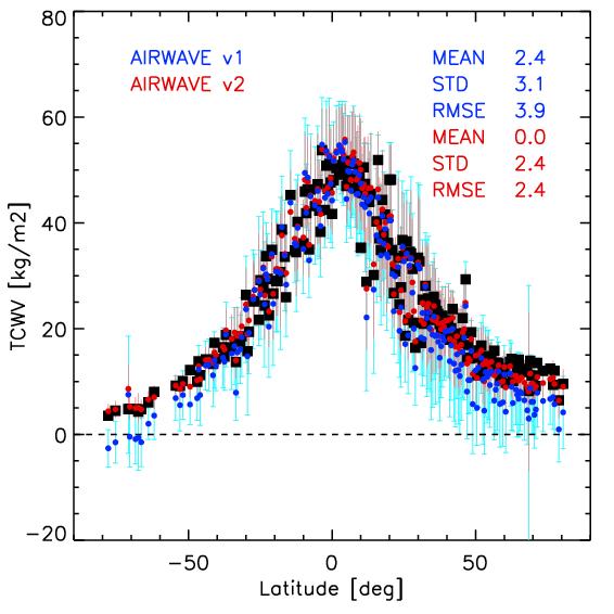
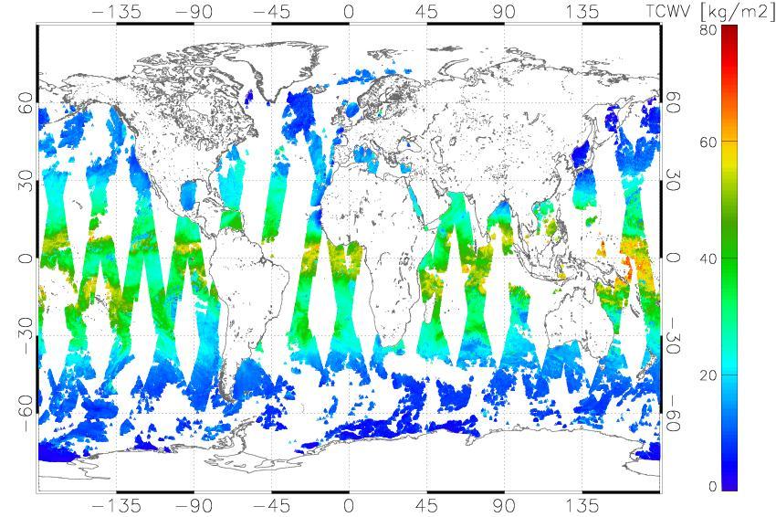
6 Processed dataset and performance evaluation SSMI - Full mission processed (from 1991 to 2012) AIRWAVE v1 AIRWAVE v2
7 Processed dataset and performance evaluation ARSA Colors=% of ATSR sea measurements in a 100 km radius around the station (about 500 stations)

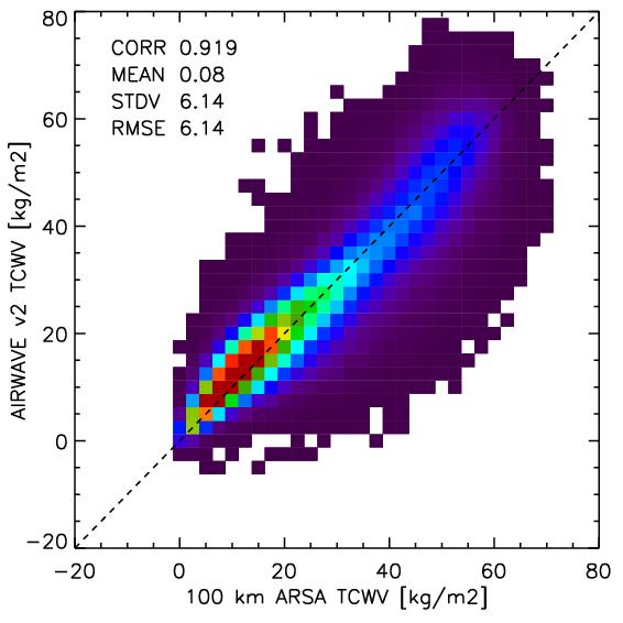
8 Processed dataset and performance evaluation ARSA ARSA-AIRWAVE
 / IGRA (NOAA) stations [different p levels integrated TCWV, different quality checks, etc ]: it is possible to look at possible")
9 Processed dataset and performance evaluation Evaluation station by station ARSA ID:3808(50m) LATITUDE:50.2 LONGITUDE:-5.3 ID:98433(14m) LATITUDE:14.6 LONGITUDE:121.4 extension of the work to common ARSA (CNRS) / IGRA (NOAA) stations [different p levels integrated TCWV, different quality checks, etc ]: it is possible to look at possible discrepancies

10 Inter-tropical Convergence Zone (ITCZ) analysis ITCZ The ITCZ is the area near the equator where the northeast and southeast trade winds come together. It appears as a band of clouds, usually thunderstorms, circling the globe close to the equator. July January
11 Inter-tropical Convergence Zone (ITCZ) analysis Variation in the location of the ITCZ affects rainfall in many equatorial nations, and so in the wet and dry seasons of the tropics. Longer term changes of the ITCZ can result in severe droughts or flooding in nearby areas. Understanding its variability is essential for improving global climate models. Our goal: Study the ITCZ position

 B-splines not")
.")
12 A model is used to fit the TCWV dataset and find the ITCZ (collaboration with Dept. of Statistics - University of Bologna) Use of a grid modeled on the globe (set of (cubic) B-splines not equally spaced in latitude/longitude but equally spaced on the globe). The ITCZ found as a probability distribution of the location of maximum TCWV.
13 Application of new model to AIRWAVE dataset of TCWV January 2003 with the new representation we can clearly see that data on land are interpolated (lower probability). The use of the distribution instead of the line allows to detect the double ITCZ and to quantify the extent of the ITCZ region (as ITCZ high latitude, lower latitude and central position).

14 An estimate of ITCZ position over land can be inferred from ATSR cloudy measurements. Moreover over sea the cloud information is a correlative information that should improve the results obtained with TCWV. Into AIRWAVE datasets cloudy measurements are discarded. We can therefore give an estimate for each month of the amount of clouds in each region, and around the tropics we can see the ITCZ position. Cloudiness % Data limited to +/- 30 lat
15 Application of new model to ATSR Cloudy measurements and to TCWV (January 2003) - Comparison with GlobVapour AIRWAVE TCWV dataset GlobVapour TCWV dataset* ATSR Cloud dataset *GlobVapour: Dataset of MERIS (UV-VIS) and SSMI (MW) TCWV daytime spatial resolution : 0.5x0.5 deg. time range:
16 Application of new model to ATSR Cloudy measurements and to TCWV (January 2003) - Comparison with GlobVapour AIRWAVE TCWV dataset Raw approximations over land Good over sea GlobVapour TCWV dataset ATSR Cloud dataset Good over land
17 Application of new model to merged ATSR Cloudy measurements and TCWV (January and June 2003) - Comparison with GlobVapour merged AIRWAVE TCWV and Cloud dataset January GlobVapour TCWV dataset July


18 Application of new model to merged ATSR Cloudy measurements and TCWV (January and June 2003) - Comparison with GPCP merged TCWV and Cloud AIRWAVE dataset January GPCP precipitation dataset July


19 ITCZ central position: mean value, coverage of all datasets
![Residual [deg] Latitude [deg] Trends analysis f k = a + bt + c n cos ωt n 8 n=1 + d n sin ωt n + e ONI ω = 2π T T =](/docs-images/96/127332580/images/20-0.jpg "3 months ONI = Oceanic Niño Index (3-month SST Anomaly for Niño) ITCZ position (LON=20 deg) Months since November")
20 Residual [deg] Latitude [deg] Trends analysis f k = a + bt + c n cos ωt n 8 n=1 + d n sin ωt n + e ONI ω = 2π T T = 3 months ONI = Oceanic Niño Index (3-month SST Anomaly for Niño) ITCZ position (LON=20 deg) Months since November 1991
![Trend [deg/decade] ITCZ central position: trend 1991-2012 vs GPCP and ECMWF](/docs-images/96/127332580/images/21-0.jpg "CP AIRWAVE TCWV + CLOUD ECMWF CP GPCP AIRWAVE TCWV + CLOUD GPCP Longitude")
21 Trend [deg/decade] ITCZ central position: trend vs GPCP and ECMWF CP AIRWAVE TCWV + CLOUD ECMWF CP GPCP AIRWAVE TCWV + CLOUD GPCP Longitude [deg]
![Trend [deg/decade] ITCZ central position: trend 1991-2012 vs GPCP and ECMWF CP](/docs-images/96/127332580/images/22-0.jpg "AIRWAVE TCWV + CLOUD ECMWF CP GPCP AIRWAVE TCWV + CLOUD ECMWF CP Longitude")
22 Trend [deg/decade] ITCZ central position: trend vs GPCP and ECMWF CP AIRWAVE TCWV + CLOUD ECMWF CP GPCP AIRWAVE TCWV + CLOUD ECMWF CP Longitude [deg]


")

23 AIRWAVE v2: application to SLSTR measurements The Sea and Land Surface Temperature Radiometer (SLSTR) has a strong heritage from AATSR instrument on Envisat
 H2O variability (x0.5, 1, 1.")
24 AIRWAVE v2: application to SLSTR measurements Scenarios Across track position (-450/450, step: 90) Instrument (SLSTR) Latitude (TRN,TRS, MDN, MDS, PLN, PLS) Season (JAN, APR, JUL, OCT) H2O variability (x0.5, 1, 1.5) Effect on RTM inputs NADIR and FORWARD angles Slit function T, p, VMRs, SST, Emissivity T, p, VMRs, SST, Emissivity H2O VMR

25 AIRWAVE v2: application to SLSTR measurements About 500 products/day (about every 3min sensing time)


26 AIRWAVE v2: application to SLSTR measurements AIRWAVEv2 SSMI SSMI - AIRWAVEv2 Low clouds: Quicklook or CALIPSO
27 Conclusions AIRWAVE v2 reduces the bias and the spread mainly at high latitudes respect to v1. Compared with SSMI and ARSA. ITCZ position trend: feasible with AIRWAVE TCWV monthly means + cloudy measurements. It is possible to apply AIRWAVE to SLSTR/S3 measurements: first results are encouraging! Thank You!
 data in these regions.")
28 The GNSS-derived Path Delay (GPD) algorithm was developed by the University of Porto aiming at computing the wet troposphere correction (WTC) for coastal regions where Micro-wave Radiometer (MWR) observations are invalid, envisaging the recovery of the Radar Altimeter (RA) data in these regions. The GPD-derived WTC is based on a spacetime optimal interpolation that combines path delays measured by MWR and computed at more than 800 coastal/island Global Navigation Satellite System) GNSS stations. Its most recent version, the GPD Plus (GPD+) estimates the WTC globally relying also on path delay observations from 19 scanning imaging MWR on-board various remote sensing missions. After adequate tuning, the GPD+ is applicable to any altimetric mission with or without an on-board MWR, as CryoSat-2 for which only a NWM-derived WTC would be, otherwise, available. To ensure consistency and WTC long term stability, and prior to their use in the GPD+, path delay observations from all radiometers were previously inter-calibrated with respect to the Special Sensor Microwave Imager (SSM/I) and SSMI/I Sounder (SSM/IS). In the context of IDEAS+ (WP 3327, J. Bouffard), AATSR AIRWAVE V2 was used to estimate the WTC through GDP+, preliminary results were presented at the 10 th Coastal Altimetry Workshop (Florence, February 2017). The image below displays the measure of improvement in RA Sea Level Anomaly (SLA) when using AIRWAVE with respect to ERA-I and MWR (ESA) TCWV. SLA Var. diff at crossovers > 0 => degradation SLA Var. diff at crossovers < 0 => improvement As can be seen, for this particular application AIRWAVE performances are similar to ECMWF and much better than ESA MWR.
ANNAlS Of GEOPHYSICS, 61, fast Track 8, 2018; doi: /ag-7524
 Validation of the Advanced Infra-red Water Vapour Estimator (AIrWAVE) total Column Water Vapour using Satellite and radiosonde products ENzO PAPANdREA 1,2,*, STEfANO CASAdIO 1, ERMINIA de GRANdIS 1, ElISA
Characteristics of Global Precipitable Water Revealed by COSMIC Measurements
 Characteristics of Global Precipitable Water Revealed by COSMIC Measurements Ching-Yuang Huang 1,2, Wen-Hsin Teng 1, Shu-Peng Ho 3, Ying-Hwa Kuo 3, and Xin-Jia Zhou 3 1 Department of Atmospheric Sciences,
EUMETSAT STATUS AND PLANS
 1 EUM/TSS/VWG/15/826793 07/10/2015 EUMETSAT STATUS AND PLANS François Montagner, Marine Applications Manager, EUMETSAT WMO Polar Space Task Group 5 5-7 October 2015, DLR, Oberpfaffenhofen PSTG Strategic
OSSE to infer the impact of Arctic AMVs extracted from highly elliptical orbit imagery
 OSSE to infer the impact of Arctic AMVs extracted from highly elliptical orbit imagery L. Garand 1 Y. Rochon 1, S. Heilliette 1, J. Feng 1, A.P. Trishchenko 2 1 Environment Canada, 2 Canada Center for
APPENDIX 2 OVERVIEW OF THE GLOBAL PRECIPITATION MEASUREMENT (GPM) AND THE TROPICAL RAINFALL MEASURING MISSION (TRMM) 2-1
 AND THE TROPICAL RAINFALL MEASURING MISSION (TRMM) 2-1") APPENDIX 2 OVERVIEW OF THE GLOBAL PRECIPITATION MEASUREMENT (GPM) AND THE TROPICAL RAINFALL MEASURING MISSION (TRMM) 2-1 1. Introduction Precipitation is one of most important environmental parameters.
APPENDIX 2 OVERVIEW OF THE GLOBAL PRECIPITATION MEASUREMENT (GPM) AND THE TROPICAL RAINFALL MEASURING MISSION (TRMM) 2-1 1. Introduction Precipitation is one of most important environmental parameters.
CONTRIBUTION TO ATMOSPHERIC ECVs
 CONTRIBUTION TO ATMOSPHERIC ECVs Piera Raspollini, Ugo Cortesi Istituto di Fisica Applicata "Nello Carrara", IFAC-CNR, Firenze Luca Palchetti Istituto Nazionale di Ottica, INO-CNR, Firenze Bianca Maria
Presented at the FIG Congress 2018, May 6-11, 2018 in Istanbul, Turkey
 Presented at the FIG Congress 2018, May 6-11, 2018 in Istanbul, Turkey Paper ID: 9253 (Peer Review) By: Amalina Izzati Abdul Hamid, Ami Hassan Md Din & Kamaludin Mohd Omar Geomatic Innovation Research
P. Cipollini, H. Snaith - A short course on Altimetry. Altimetry 2 - Data processing (from satellite height to sea surface height)
") P. Cipollini, H. Snaith - A short course on Altimetry Altimetry 2 - Data processing (from satellite height to sea surface height) 1 2 Satellite height to sea surface height The altimeter measures the altitude
P. Cipollini, H. Snaith - A short course on Altimetry Altimetry 2 - Data processing (from satellite height to sea surface height) 1 2 Satellite height to sea surface height The altimeter measures the altitude
Long-Term Time Series of Water Vapour Total Columns from GOME, SCIAMACHY and GOME-2
 Graphics: ESA Graphics: ESA Graphics: ESA Long-Term Time Series of Water Vapour Total Columns from GOME, SCIAMACHY and GOME-2 S. Noël, S. Mieruch, H. Bovensmann, J. P. Burrows Institute of Environmental
Operational systems for SST products. Prof. Chris Merchant University of Reading UK
 Operational systems for SST products Prof. Chris Merchant University of Reading UK Classic Images from ATSR The Gulf Stream ATSR-2 Image, ƛ = 3.7µm Review the steps to get SST using a physical retrieval
Generating a Climate data record for SST from Passive Microwave observations
 ESA Climate Change Initiative Phase-II Sea Surface Temperature (SST) www.esa-sst-cci.org Generating a Climate data record for SST from Passive Microwave observations Jacob L. Høyer, Jörg Steinwagner, Pia
ADVANCEMENTS IN SNOW MONITORING
 Polar Space Task Group ADVANCEMENTS IN SNOW MONITORING Thomas Nagler, ENVEO IT GmbH, Innsbruck, Austria Outline Towards a pan-european Multi-sensor Snow Product SnowPEx Summary Upcoming activities SEOM
SSS retrieval from space Comparison study using Aquarius and SMOS data
 44 th International Liège Colloquium on Ocean Dynamics 7-11 May 2012 SSS retrieval from space Comparison study using Aquarius and SMOS data Physical Oceanography Department Institute of Marine Sciences
Model errors in tropical cloud and precipitation revealed by the assimilation of MW imagery
 Model errors in tropical cloud and precipitation revealed by the assimilation of MW imagery Katrin Lonitz, Alan Geer, Philippe Lopez + many other colleagues 20 November 2014 Katrin Lonitz ( ) Tropical
Description of Precipitation Retrieval Algorithm For ADEOS II AMSR
 Description of Precipitation Retrieval Algorithm For ADEOS II Guosheng Liu Florida State University 1. Basic Concepts of the Algorithm This algorithm is based on Liu and Curry (1992, 1996), in which the
S3 Product Notice Altimetry
 S3 Product Notice Altimetry Mission Sensor Product S3-A SRAL / MWR LAND L2 NRT, STC and NTC Product Notice ID Issue/Rev Date Version 1.0 Preparation S3A.PN-STM-L2L.06 04-April-2018 This Product Notice
Sentinel-3: Lessons from AATSR/MERIS Synergy. Peter North Swansea University
 Sentinel-3: Lessons from AATSR/MERIS Synergy Peter North Swansea University Introduction ESA projects relevant to Sentinel-3: Aerosol CCI MERIS/AATSR Synergy GlobAlbedo SEN4LST S3 Algorithm development
HY-2A Satellite User s Guide
 National Satellite Ocean Application Service 2013-5-16 Document Change Record Revision Date Changed Pages/Paragraphs Edit Description i Contents 1 Introduction to HY-2 Satellite... 1 2 HY-2 satellite data
Applications of Data Assimilation in Earth System Science. Alan O Neill University of Reading, UK
 Applications of Data Assimilation in Earth System Science Alan O Neill University of Reading, UK NCEO Early Career Science Conference 16th 18th April 2012 Introduction to data assimilation Page 2 of 20
Coastal Altimetry Workshop February 5-7, Supported by NOAA (Stan Wilson) NASA (Eric Lindstrom, Lee Fu)
 NASA (Eric Lindstrom, Lee Fu)") Coastal Altimetry Workshop February 5-7, 2008 Organized by: Laury Miller, Walter Smith: NOAA/NESDIS Ted Strub, Amy Vandehey: CIOSS/COAS/OSU With help from many of you! Supported by NOAA (Stan Wilson) NASA
Coastal Altimetry Workshop February 5-7, 2008 Organized by: Laury Miller, Walter Smith: NOAA/NESDIS Ted Strub, Amy Vandehey: CIOSS/COAS/OSU With help from many of you! Supported by NOAA (Stan Wilson) NASA
ESA Cloud-CCI Phase 1 Results Climate Research Perspective
 ESA Cloud-CCI Phase 1 Results Climate Research Perspective Claudia Stubenrauch Laboratoire de Météorologie Dynamique, France and Cloud-CCI Team Outline Ø Challenges to retrieve cloud properties Ø What
New retrieval algorithm for the wet tropospheric correction of altimetry missions
 New retrieval algorithm for the wet tropospheric correction of altimetry missions A. Rahmani, E. Obligis and L. Eymard CLS/LOCEAN MicroRad Conference March 2008 Page n 1/13 Introduction Altimeters are
Direct assimilation of all-sky microwave radiances at ECMWF
 Direct assimilation of all-sky microwave radiances at ECMWF Peter Bauer, Alan Geer, Philippe Lopez, Deborah Salmond European Centre for Medium-Range Weather Forecasts Reading, Berkshire, UK Slide 1 17
SST in Climate Research
 SST in Climate Research Roger Saunders, Met Office with inputs from Nick Rayner, John Kennedy, Rob Smith, Karsten Fennig, Sarah Millington, Owen Embury. This work is supported by the Joint DECC and Defra
Sentinel-3 Sea and Land Surface Temperature Radiometer (SLSTR) Mireya Etxaluze (STFC RAL Space)
 Mireya Etxaluze (STFC RAL Space)") Sentinel-3 Sea and Land Surface Temperature Radiometer (SLSTR) Mireya Etxaluze (STFC RAL Space) RAL Space Radiometry Group Dave Smith Mireya Etxaluze, Ed Polehampton, Caroline Cox, Tim Nightingale, Dan
Sentinel-3 Sea and Land Surface Temperature Radiometer (SLSTR) Mireya Etxaluze (STFC RAL Space) RAL Space Radiometry Group Dave Smith Mireya Etxaluze, Ed Polehampton, Caroline Cox, Tim Nightingale, Dan
Comparison results: time series Margherita Grossi
 Comparison results: time series Margherita Grossi GOME Evolution Climate Product v2.01 vs. ECMWF ERAInterim GOME Evolution Climate Product v2.01 vs. SSM/I HOAPS4 In order to assess the quality and stability
Introduction to Data Assimilation
 Introduction to Data Assimilation Alan O Neill Data Assimilation Research Centre University of Reading What is data assimilation? Data assimilation is the technique whereby observational data are combined
School on Modelling Tools and Capacity Building in Climate and Public Health April Rainfall Estimation
 2453-6 School on Modelling Tools and Capacity Building in Climate and Public Health 15-26 April 2013 Rainfall Estimation CECCATO Pietro International Research Institute for Climate and Society, IRI The
Trend and Variability of the Atmospheric Water Vapor: A Mean Sea Level Issue
 SEPTEMBER 2014 T H A O E T A L. 1881 Trend and Variability of the Atmospheric Water Vapor: A Mean Sea Level Issue SOULIVANH THAO CLS, Ramonville Saint-Agne, France LAURENCE EYMARD LOCEAN/CNRS, Paris, France
An Overview of Atmospheric Analyses and Reanalyses for Climate
 An Overview of Atmospheric Analyses and Reanalyses for Climate Kevin E. Trenberth NCAR Boulder CO Analysis Data Assimilation merges observations & model predictions to provide a superior state estimate.
MERIS and OSCAR: Online Services for Correcting Atmosphere in Radar
 National Aeronautics and Space Administration MERIS and OSCAR: Online Services for Correcting Atmosphere in Radar Eric Fielding and Evan Fishbein Jet Propulsion Laboratory, California Inst. of Tech. Zhenhong
UPDATE OF REGIONAL WEATHER AND SMOKE HAZE (December 2017)
") UPDATE OF REGIONAL WEATHER AND SMOKE HAZE (December 2017) 1. Review of Regional Weather Conditions for November 2017 1.1 In November 2017, Southeast Asia experienced inter-monsoon conditions in the first
UPDATE OF REGIONAL WEATHER AND SMOKE HAZE (December 2017) 1. Review of Regional Weather Conditions for November 2017 1.1 In November 2017, Southeast Asia experienced inter-monsoon conditions in the first
New Technique for Retrieving Liquid Water Path over Land using Satellite Microwave Observations
 New Technique for Retrieving Liquid Water Path over Land using Satellite Microwave Observations M.N. Deeter and J. Vivekanandan Research Applications Library National Center for Atmospheric Research Boulder,
TECH NOTE. New Mean Sea Surface for the CryoSat-2 L2 SAR Chain. Andy Ridout, CPOM, University College London
 TECH NOTE Subject : From : To : New Mean Sea Surface for the CryoSat-2 L2 SAR Chain Andy Ridout, CPOM, University College London Tommaso Parrinello, CryoSat Mission Manager, ESRIN Date : 30 th June 2014
This is version v0.2 of this report issued together with the SIT and SIV data sets at the ICDC ESA-CCI- Projekt web page
 Report about Retrieval of sea-ice volume (SIV) from SICCI-2 sea-ice thickness (SIT) data and combined OSI-450 and SICCI-2 sea-ice concentration (SIC) data version v0.2, June 2018 by Stefan Kern, ICDC,
Cloud masking as cross-cutting issue
 Cloud masking as cross-cutting issue Presentation to CEOS/WGCV activity project planning meeting Rainer Hollmann, Cornelia Schlundt, Satellite based Climate Monitoring Deutscher Wetterdienst Outline Need
TRMM Multi-satellite Precipitation Analysis (TMPA)
") TRMM Multi-satellite Precipitation Analysis (TMPA) (sometimes known as 3B42/43, TRMM product numbers) R. Adler, G. Huffman, D. Bolvin, E. Nelkin, D. Wolff NASA/Goddard Laboratory for Atmospheres with key
TRMM Multi-satellite Precipitation Analysis (TMPA) (sometimes known as 3B42/43, TRMM product numbers) R. Adler, G. Huffman, D. Bolvin, E. Nelkin, D. Wolff NASA/Goddard Laboratory for Atmospheres with key
THREE-WAY ERROR ANALYSIS BETWEEN AATSR, AMSR-E AND IN SITU SEA SURFACE TEMPERATURE OBSERVATIONS.
 THREE-WAY ERROR ANALYSIS BETWEEN AATSR, AMSR-E AND IN SITU SEA SURFACE TEMPERATURE OBSERVATIONS. Anne O Carroll (1), John Eyre (1), and Roger Saunders (1) (1) Met Office, Satellite Applications, Fitzroy
ANNUAL CLIMATE REPORT 2016 SRI LANKA
 ANNUAL CLIMATE REPORT 2016 SRI LANKA Foundation for Environment, Climate and Technology C/o Mahaweli Authority of Sri Lanka, Digana Village, Rajawella, Kandy, KY 20180, Sri Lanka Citation Lokuhetti, R.,
Validation Report: WP5000 Regional tidal correction (Noveltis)
") Consortium Members ESA Cryosat Plus for Oceans Validation Report: WP5000 Regional tidal correction (Noveltis) Reference: Nomenclature: CLS-DOS-NT-14-083 CP4O-WP5000-VR-03 Issue: 2. 0 Date: Jun. 20, 14
Consortium Members ESA Cryosat Plus for Oceans Validation Report: WP5000 Regional tidal correction (Noveltis) Reference: Nomenclature: CLS-DOS-NT-14-083 CP4O-WP5000-VR-03 Issue: 2. 0 Date: Jun. 20, 14
Geophysical Correction Application in Level 2 CryoSat Data Products
 ESRIN-EOP-GQ / IDEAS IDEAS-VEG-IPF-MEM-1288 Version 2.0 29 July 2014 Geophysical Correction Application in Level 2 CryoSat Data Products TABLE OF CONTENTS 1 INTRODUCTION... 3 1.1 Purpose and Scope... 3
ASSIMILATION EXPERIMENTS WITH DATA FROM THREE CONICALLY SCANNING MICROWAVE INSTRUMENTS (SSMIS, AMSR-E, TMI) IN THE ECMWF SYSTEM
 IN THE ECMWF SYSTEM") ASSIMILATION EXPERIMENTS WITH DATA FROM THREE CONICALLY SCANNING MICROWAVE INSTRUMENTS (SSMIS, AMSR-E, TMI) IN THE ECMWF SYSTEM Niels Bormann 1, Graeme Kelly 1, Peter Bauer 1, and Bill Bell 2 1 ECMWF,
ASSIMILATION EXPERIMENTS WITH DATA FROM THREE CONICALLY SCANNING MICROWAVE INSTRUMENTS (SSMIS, AMSR-E, TMI) IN THE ECMWF SYSTEM Niels Bormann 1, Graeme Kelly 1, Peter Bauer 1, and Bill Bell 2 1 ECMWF,
Parameterization of the surface emissivity at microwaves to submillimeter waves
 Parameterization of the surface emissivity at microwaves to submillimeter waves Catherine Prigent, Filipe Aires, Observatoire de Paris and Estellus Lise Kilic, Die Wang, Observatoire de Paris with contributions
NOAA In Situ Satellite Blended Analysis of Surface Salinity: Preliminary Results for
 NOAA In Situ Satellite Blended Analysis of Surface Salinity: Preliminary Results for 2010-2012 P.Xie 1), T. Boyer 2), E. Bayler 3), Y. Xue 1), D. Byrne 2), J.Reagan 2), R. Locarnini 2), F. Sun 1), R.Joyce
Sea surface temperatures with a certain degree of uncertainty. Chris Merchant
 Sea surface temperatures with a certain degree of uncertainty Chris Merchant 2 July 2015 RMS DA SIG, ECMWF www.reading.ac.uk Acknowledgements ESA Sea Surface Temperature Climate Change Initiative / ARC
Ensemble-variational assimilation with NEMOVAR Part 2: experiments with the ECMWF system
 Ensemble-variational assimilation with NEMOVAR Part 2: experiments with the ECMWF system Toulouse, 20/06/2017 Marcin Chrust 1, Hao Zuo 1 and Anthony Weaver 2 1 ECMWF, UK 2 CERFACS, FR Marcin.chrust@ecmwf.int
Using HIRS Observations to Construct Long-Term Global Temperature and Water Vapor Profile Time Series
 Using HIRS Observations to Construct Long-Term Global Temperature and Water Vapor Profile Time Series Lei Shi and John J. Bates National Climatic Data Center, National Oceanic and Atmospheric Administration
C. Jimenez, C. Prigent, F. Aires, S. Ermida. Estellus, Paris, France Observatoire de Paris, France IPMA, Lisbon, Portugal
 All-weather land surface temperature estimates from microwave satellite observations, over several decades and real time: methodology and comparison with infrared estimates C. Jimenez, C. Prigent, F. Aires,
From El Nino to Atlantic Nino: pathways as seen in the QuikScat winds
 From El Nino to Atlantic Nino: pathways as seen in the QuikScat winds Rong Fu 1, Lei Huang 1, Hui Wang 2 Presented by Nicole Smith-Downey 1 1 Jackson School of Geosciences, The University of Texas at Austin
Examples on Sentinel data applications in Finland, possibilities, plans and how NSDC will be utilized - Snow
 Examples on Sentinel data applications in Finland, possibilities, plans and how NSDC will be utilized - Snow Kari Luojus, Jouni Pulliainen, Jyri Heilimo, Matias Takala, Juha Lemmetyinen, Ali Arslan, Timo
AIRS and IASI Precipitable Water Vapor (PWV) Absolute Accuracy at Tropical, Mid-Latitude, and Arctic Ground-Truth Sites
 Absolute Accuracy at Tropical, Mid-Latitude, and Arctic Ground-Truth Sites") AIRS and IASI Precipitable Water Vapor (PWV) Absolute Accuracy at Tropical, Mid-Latitude, and Arctic Ground-Truth Sites Robert Knuteson, Sarah Bedka, Jacola Roman, Dave Tobin, Dave Turner, Hank Revercomb
AIRS and IASI Precipitable Water Vapor (PWV) Absolute Accuracy at Tropical, Mid-Latitude, and Arctic Ground-Truth Sites Robert Knuteson, Sarah Bedka, Jacola Roman, Dave Tobin, Dave Turner, Hank Revercomb
The MODIS Cloud Data Record
 The MODIS Cloud Data Record Brent C. Maddux 1,2 Steve Platnick 3, Steven A. Ackerman 1 Paul Menzel 1, Kathy Strabala 1, Richard Frey 1, 1 Cooperative Institute for Meteorological Satellite Studies, 2 Department
Experiences of using ECV datasets in ECMWF reanalyses including CCI applications. David Tan and colleagues ECMWF, Reading, UK
 Experiences of using ECV datasets in ECMWF reanalyses including CCI applications David Tan and colleagues ECMWF, Reading, UK Slide 1 Main points Experience shows benefit of integrated & iterative approach
Sentinel-3A Product Notice STM L2 Marine (NRT, STC and NTC)
") Sentinel-3A Product Notice STM L2 Marine (NRT, STC and NTC) Mission Sensor Product S3-A SRAL/MWR L2 NRT STC and NTC (Marine Products) Product Notice ID S3A.PN-STM-L2M.01 EUM/OPS-SEN3/DOC/16/893228 Issue
Sentinel-3A Product Notice STM L2 Marine (NRT, STC and NTC) Mission Sensor Product S3-A SRAL/MWR L2 NRT STC and NTC (Marine Products) Product Notice ID S3A.PN-STM-L2M.01 EUM/OPS-SEN3/DOC/16/893228 Issue
Data Short description Parameters to be used for analysis SYNOP. Surface observations by ships, oil rigs and moored buoys
 3.2 Observational Data 3.2.1 Data used in the analysis Data Short description Parameters to be used for analysis SYNOP Surface observations at fixed stations over land P,, T, Rh SHIP BUOY TEMP PILOT Aircraft
Lessons learnt from the validation of Level1 and Level2 hyperspectral sounders observations
 http://ara.abct.lmd.polytechnique.fr/ Lessons learnt from the validation of Level1 and Level2 hyperspectral sounders observations N. A. Scott, R. Armante, A. Chédin, N. Jacquinet, V. Capelle, A. Feofilov,
The Global Precipitation Climatology Project (GPCP) CDR AT NOAA: Research to Real-time Climate Monitoring
 CDR AT NOAA: Research to Real-time Climate Monitoring") The Global Precipitation Climatology Project (GPCP) CDR AT NOAA: Research to Real-time Climate Monitoring Robert Adler, Matt Sapiano, Guojun Gu University of Maryland Pingping Xie (NCEP/CPC), George Huffman
The Global Precipitation Climatology Project (GPCP) CDR AT NOAA: Research to Real-time Climate Monitoring Robert Adler, Matt Sapiano, Guojun Gu University of Maryland Pingping Xie (NCEP/CPC), George Huffman
Outline of 4 Lectures
 Outline of 4 Lectures 1. Sept. 17, 2008: TC best track definition and datasets, global distribution of TCs; Review of history of meteorological satellites, introducing different orbits, scanning patterns,
Ocean data assimilation for reanalysis
 Ocean data assimilation for reanalysis Matt Martin. ERA-CLIM2 Symposium, University of Bern, 14 th December 2017. Contents Introduction. On-going developments to improve ocean data assimilation for reanalysis.
School on Modelling Tools and Capacity Building in Climate and Public Health April Remote Sensing
 2453-5 School on Modelling Tools and Capacity Building in Climate and Public Health 15-26 April 2013 Remote Sensing CECCATO Pietro International Research Institute for Climate and Society, IRI The Earth
Applications of Data Assimilation in Earth System Science. Alan O Neill Data Assimilation Research Centre University of Reading
 Applications of Data Assimilation in Earth System Science Alan O Neill Data Assimilation Research Centre University of Reading DARC Current & Future Satellite Coverage Formation Flying - Afternoon Constellation
Observations of Arctic snow and sea ice thickness from satellite and airborne surveys. Nathan Kurtz NASA Goddard Space Flight Center
 Observations of Arctic snow and sea ice thickness from satellite and airborne surveys Nathan Kurtz NASA Goddard Space Flight Center Decline in Arctic sea ice thickness and volume Kwok et al. (2009) Submarine
El Niño, South American Monsoon, and Atlantic Niño links as detected by a. TOPEX/Jason Observations
 El Niño, South American Monsoon, and Atlantic Niño links as detected by a decade of QuikSCAT, TRMM and TOPEX/Jason Observations Rong Fu 1, Lei Huang 1, Hui Wang 2, Paola Arias 1 1 Jackson School of Geosciences,
Evaluation of radar altimeter path delay using ECMWF pressure-level and model-level fields
 Evaluation of radar altimeter path delay using ECMWF pressure-level and model-level fields Author: Saleh Abdalla A report for ESA contract 21519/ 08/ I-OL (CCN2) Series: ECMWF - ESA Contract Report A full
COMPARISON OF SATELLITE DERIVED OCEAN SURFACE WIND SPEEDS AND THEIR ERROR DUE TO PRECIPITATION
 COMPARISON OF SATELLITE DERIVED OCEAN SURFACE WIND SPEEDS AND THEIR ERROR DUE TO PRECIPITATION A.-M. Blechschmidt and H. Graßl Meteorological Institute, University of Hamburg, Hamburg, Germany ABSTRACT
GEOSC/METEO 597K Kevin Bowley Kaitlin Walsh
 GEOSC/METEO 597K Kevin Bowley Kaitlin Walsh Timeline of Satellites ERS-1 (1991-2000) NSCAT (1996) Envisat (2002) RADARSAT (2007) Seasat (1978) TOPEX/Poseidon (1992-2005) QuikSCAT (1999) Jason-2 (2008)
Ice sheet mass balance from satellite altimetry. Kate Briggs (Mal McMillan)
") Ice sheet mass balance from satellite altimetry Kate Briggs (Mal McMillan) Outline Background Recap 25 year altimetry record Recap Measuring surface elevation with altimetry Measuring surface elevation
Ice sheet mass balance from satellite altimetry Kate Briggs (Mal McMillan) Outline Background Recap 25 year altimetry record Recap Measuring surface elevation with altimetry Measuring surface elevation
The Impact of Observational data on Numerical Weather Prediction. Hirokatsu Onoda Numerical Prediction Division, JMA
 The Impact of Observational data on Numerical Weather Prediction Hirokatsu Onoda Numerical Prediction Division, JMA Outline Data Analysis system of JMA in Global Spectral Model (GSM) and Meso-Scale Model
THE ASSIMILATION OF SURFACE-SENSITIVE MICROWAVE SOUNDER RADIANCES AT ECMWF
 THE ASSIMILATION OF SURFACE-SENSITIVE MICROWAVE SOUNDER RADIANCES AT ECMWF Enza Di Tomaso and Niels Bormann European Centre for Medium-range Weather Forecasts Shinfield Park, Reading, RG2 9AX, United Kingdom
ECMWF: Weather and Climate Dynamical Forecasts
 ECMWF: Weather and Climate Dynamical Forecasts Medium-Range (0-day) Partial coupling Extended + Monthly Fully coupled Seasonal Forecasts Fully coupled Atmospheric model Atmospheric model Wave model Wave
TAMSAT: LONG-TERM RAINFALL MONITORING ACROSS AFRICA
 TAMSAT: LONG-TERM RAINFALL MONITORING ACROSS AFRICA Ross Maidment, Emily Black, Matthew Young and Dagmawi Asfaw TAMSAT, University of Reading Helen Greatrex IRI, Columbia University 13 th EUMETSAT User
ESA-CCI CMUG Workpackages
 ESA-CCI CMUG Workpackages WP3.9 Assessments of glaciers, land cover and sea-level data for hydrological modelling of the Arctic ocean drainage basi n WP3.8 Cross-assessments of clouds, soil moisture, water
ESA Climate Change Initiative (CCI)
") ESA Climate Change Initiative (CCI) New ESA Programme with the aim to contribute to worldwide efforts to generate Essential Climate Variables (ECVs) C. Zehner Barcelona, 07/09/2009 Two climate action paths
ESA Climate Change Initiative (CCI) New ESA Programme with the aim to contribute to worldwide efforts to generate Essential Climate Variables (ECVs) C. Zehner Barcelona, 07/09/2009 Two climate action paths
Lake level variations from satellite radar altimetry with retracking of multi-leading edge
 Lake level variations from satellite radar altimetry with retracking of multi-leading edge Shirzad Roohi (shirzad.roohi@gis.uni-stuttgart.de) and Nico Sneeuw University of Stuttgart, Germany Institute
Sentinel-3A Product Notice SLSTR Level-2 Sea Surface Temperature
 Sentinel-3A Product Notice SLSTR Level-2 Sea Surface Temperature Mission Sensor Product Sentinel-3A SLSTR Level 2 Sea Surface Temperature Product Notice ID EUM/OPS-SEN3/DOC/18/984462 S3A.PN-SLSTR-L2M.003
Multi-Satellite 3D Winds Land/Atmosphere Requirements
 Multi-Satellite 3D Winds Land/Atmosphere Requirements James L Carr* Carr Astronautics 6404 Ivy Lane, #333 Greenbelt, MD 20770 August 22-23, 2017 NOAA Workshop *jcarr@carrastro.com Multi-Satellite 3D Winds
Coastal Altimetry: recent developments and proposed use in the Agulhas region. Paolo Cipollini (NOCS, UK)
") Coastal Altimetry: recent developments and proposed use in the Agulhas region Paolo Cipollini (NOCS, UK) Coastal altimetry - the concept Satellite altimetry has been designed for the open ocean 15 years
Coastal Altimetry: recent developments and proposed use in the Agulhas region Paolo Cipollini (NOCS, UK) Coastal altimetry - the concept Satellite altimetry has been designed for the open ocean 15 years
Bayesian Cloud Detection for 37 Years of Advanced Very High Resolution Radiometer (AVHRR) Global Area Coverage (GAC) Data
 Global Area Coverage (GAC) Data") remote sensing Article Bayesian Cloud Detection for 37 Years of Advanced Very High Resolution Radiometer (AVHRR) Global Area Coverage (GAC) Data Claire E. Bulgin 1,2, * ID, Jonathan P. D. Mittaz 1,3, Owen
remote sensing Article Bayesian Cloud Detection for 37 Years of Advanced Very High Resolution Radiometer (AVHRR) Global Area Coverage (GAC) Data Claire E. Bulgin 1,2, * ID, Jonathan P. D. Mittaz 1,3, Owen
Correcting Microwave Precipitation Retrievals for near- Surface Evaporation
 Correcting Microwave Precipitation Retrievals for near- Surface Evaporation The MIT Faculty has made this article openly available. Please share how this access benefits you. Your story matters. Citation
Interpretation of Polar-orbiting Satellite Observations. Atmospheric Instrumentation
 Interpretation of Polar-orbiting Satellite Observations Outline Polar-Orbiting Observations: Review of Polar-Orbiting Satellite Systems Overview of Currently Active Satellites / Sensors Overview of Sensor
Application of the UW/CIMSS high spectral resolution global IR land surface emissivity database into the RTTOV model
 Application of the UW/CIMSS high spectral resolution global IR land surface emissivity database into the RTTOV model Eva Borbas 1, Ben Ruston 2, Roger Saunders 3, Andrew Collard 3, Robert Knuteson 1, James
ATSR SST Observations of the Tropical Pacific Compared with TOPEX/Poseidon Sea Level Anomaly
 ATSR SST Observations of the Tropical Pacific Compared with TOPEX/Poseidon Sea Level Anomaly J.P.Angell and S.P.Lawrence Earth Observation Science Group, Dept. Physics and Astronomy, Space Research Centre,
NUMERICAL EXPERIMENTS USING CLOUD MOTION WINDS AT ECMWF GRAEME KELLY. ECMWF, Shinfield Park, Reading ABSTRACT
 NUMERICAL EXPERIMENTS USING CLOUD MOTION WINDS AT ECMWF GRAEME KELLY ECMWF, Shinfield Park, Reading ABSTRACT Recent monitoring of cloud motion winds (SATOBs) at ECMWF has shown an improvement in quality.
Recent Data Assimilation Activities at Environment Canada
 Recent Data Assimilation Activities at Environment Canada Major upgrade to global and regional deterministic prediction systems (now in parallel run) Sea ice data assimilation Mark Buehner Data Assimilation
Operational Climate Monitoring
 Operational Climate Monitoring Concept of Climate data records & operational climate monitoring Introduction CM SAF Examples of downstream services in Europe (e.g. WMO RCC RA VI) in US (e.g. drought monitoring)
CORRELATION BETWEEN ATMOSPHERIC COMPOSITION AND VERTICAL STRUCTURE AS MEASURED BY THREE GENERATIONS OF HYPERSPECTRAL SOUNDERS IN SPACE
 CORRELATION BETWEEN ATMOSPHERIC COMPOSITION AND VERTICAL STRUCTURE AS MEASURED BY THREE GENERATIONS OF HYPERSPECTRAL SOUNDERS IN SPACE Nadia Smith 1, Elisabeth Weisz 1, and Allen Huang 1 1 Space Science
Remote Sensing I: Basics
 Remote Sensing I: Basics Kelly M. Brunt Earth System Science Interdisciplinary Center, University of Maryland Cryospheric Science Laboratory, Goddard Space Flight Center kelly.m.brunt@nasa.gov (Based on
March was 3rd warmest month in satellite record
 April 4, 2016 Vol. 25, No. 12 For Additional Information: Dr. John Christy, (256) 961-7763 john.christy@nsstc.uah.edu Dr. Roy Spencer, (256) 961-7960 roy.spencer@nsstc.uah.edu Global Temperature Report:
I C P A C. IGAD Climate Prediction and Applications Centre Monthly Climate Bulletin, Climate Review for September 2017
 Bulletin Issue October 2017 I C P A C IGAD Climate Prediction and Applications Centre Monthly Climate Bulletin, Climate Review for September 2017 1. INTRODUCTION This bulletin reviews the September 2017
Mesoscale and High Impact Weather in the South American Monsoon Leila M. V. Carvalho 1 and Maria A. F. Silva Dias 2 1
 Mesoscale and High Impact Weather in the South American Monsoon Leila M. V. Carvalho 1 and Maria A. F. Silva Dias 2 1 University of California, Santa Barbara 2 University of Sao Paulo, Brazil Objectives
Will a warmer world change Queensland s rainfall?
 Will a warmer world change Queensland s rainfall? Nicholas P. Klingaman National Centre for Atmospheric Science-Climate Walker Institute for Climate System Research University of Reading The Walker-QCCCE
A two-season impact study of the Navy s WindSat surface wind retrievals in the NCEP global data assimilation system
 A two-season impact study of the Navy s WindSat surface wind retrievals in the NCEP global data assimilation system Li Bi James Jung John Le Marshall 16 April 2008 Outline WindSat overview and working
An update on the NOAA MSU/AMSU CDR development
 An update on the NOAA MSU/AMSU CDR development Cheng-Zhi Zou NOAA/NESDIS/Center for Satellite Applications and Research International TOVS Study Conferences (ITSC), Monterey, CA, April 14-20, 2010 1 Outline
RESULTS OF MID-LATITUDE MIPAS VALIDATION MEASUREMENTS OBTAINED BY THE SAFIRE-A AIRBORNE SPECTROMETER
 (3) RESULTS OF MID-LATITUDE MIPAS VALIDATION MEASUREMENTS OBTAINED BY THE SAFIRE-A AIRBORNE SPECTROMETER U. Cortesi (1), G. Bianchini (1), L. Palchetti (1), E. Castelli (2), B.M. Dinelli (2), G. Redaelli
Global and Regional OSEs at JMA
 Global and Regional OSEs at JMA Yoshiaki SATO and colleagues Japan Meteorological Agency / Numerical Prediction Division 1 JMA NWP SYSTEM Global OSEs Contents AMSU A over coast, MHS over land, (related
Rosemary Munro*, Graeme Kelly, Michael Rohn* and Roger Saunders
 ASSIMILATION OF METEOSAT RADIANCE DATA WITHIN THE 4DVAR SYSTEM AT ECMWF Rosemary Munro*, Graeme Kelly, Michael Rohn* and Roger Saunders European Centre for Medium Range Weather Forecasts Shinfield Park,
Bias correction of satellite data at the Met Office
 Bias correction of satellite data at the Met Office Nigel Atkinson, James Cameron, Brett Candy and Steve English ECMWF/EUMETSAT NWP-SAF Workshop on Bias estimation and correction in data assimilation,
JGOFS Open Science Conference. JGOFS Open Science Conference 5-88 May 2003 Washington, D.C.
 5-88 May 23 Washington, D.C. Constraining Fluxes at the Top: Advances in Quantifying Air-Sea Carbon Dioxide Fluxes during the JGOFS Decade Speaker: Rik Wanninkhof NOAA/AOML Commentator: Richard A. Feely
Climate Outlook through 2100 South Florida Ecological Services Office Vero Beach, FL January 13, 2015
 Climate Outlook through 2100 South Florida Ecological Services Office Vero Beach, FL January 13, 2015 Short Term Drought Map: Short-term (
AMVs in the ECMWF system:
 AMVs in the ECMWF system: Overview of the recent operational and research activities Kirsti Salonen and Niels Bormann Slide 1 AMV sample coverage: monitored GOES-15 GOES-13 MET-10 MET-7 MTSAT-2 NOAA-15