ADVANCEMENTS IN SNOW MONITORING
|
|
|
- Claire Rodgers
- 5 years ago
- Views:
Transcription


1 Polar Space Task Group ADVANCEMENTS IN SNOW MONITORING Thomas Nagler, ENVEO IT GmbH, Innsbruck, Austria
2 Outline Towards a pan-european Multi-sensor Snow Product SnowPEx Summary Upcoming activities


3 SEOM S1-4SCI SNOW: DEVELOPMENT OF PAN-EUROPEAN MULTI-SENSOR SNOW MAPPING METHODS EXPLOITING S1 PROJECT TEAM FMI Environmental Earth Observation IT GmbH Innsbruck AT - Principle Investigator Finnish Meteorological Institute Helsinki, FI University of Zurich, Zurich, CH Finnish Environment Institute Helsinki, FI NORUT, Tromsö, NO PERIOD: Primary Objectives Develop, implement and validate methods and tools for generating maps of snowmelt area based on SAR data of the S1 mission Combination of S1 wet snow products with snow products from optical sensors of Sentinel-3 / Sentinel-2 Use developed algorithm to generate advanced pan-european snow extent and condition (dry/wet) maps

4 Combined SAR & OPT Snow Product Addressed Tasks: - SAR snow mapping in mountains and low lands - Combination of optical and SAR - Optical Snow Products: cloud coverage
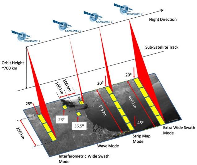

5 Sentinel-1 and Sentinel-3 Sensor Overview S1 SAR IW Mode

, 348, doi:10.")
6 Baseline Sentinel-1 VV&VH Snow Mapping Method Track April 2015, VV (Nagler et al. 2016; Rem. Sens., 2016, 8(4), 348, doi: /rs )


7 Algorithm Intercomparison Mountains - Swiss Alps 4 May 2016 Reference Data: Sentinel-2 SAR Data: Sentinel-1 IWS S2 Klein 100 m S1 WS ENVEO 100 m S1 WS UZH 100 m S1 WS NORUT 100 m SAR Alg. Intercomparison UZH NORUT ENVEO UZH NORUT


8 Sentinel-1 Wet Snow Maps Mountain regions

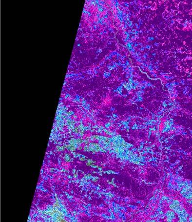
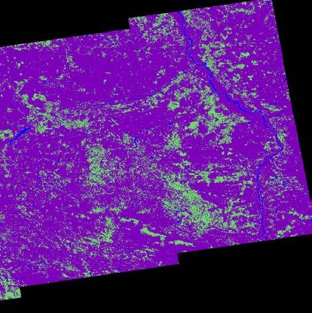

9 Low Lands-Dense Forest-Cultivated Areas/Poland 16 Feb 2016 Warsaw Warsaw Landcover LS8 Salomonson 100 m S1 WS ENVEO 100 m Forests Maksed S1 WS ENVEO 100 m

![WS image σ 0 VH [db] WS](/docs-images/96/126591778/images/10-2.jpg "image σ 0 VV [db] 4 Apr")

10 Radar backscatter of Wet Snow Image - Europe WS image σ 0 VH [db] WS image σ 0 VV [db] 4 Apr 2017 Background image: C³ - Cryoland Cloud Cleared
: 0.5 1.6, -3.")

11 Concept for SENTINEL-3 Snow Mapping using SLSTR (AATSR) and OLCI (MERIS) Sentinel-3: SLSTR (follow on of AATSR): , -3.7 µm + TIR 500 m / 1 km OLCI (follow on of MERIS): µm; 300 m Daily Global Coverage Fractional Snow Extent estimated using multi-spectral algorithm Synergistic SLSTR & OLCI TOA Product not available use only SLSTR TOA Product


12 Fractional Snow Cover Map 28 March 2017 Sentinel-3 SLSTR FSC Note: SLSTR Band co-location problems (1.6 µm band)


13 Assimilated Snow Cover Product Cloud-cleared Daily Cryoland Snow Extent product Observed by MODIS Assimilated Snow Extent Product FSC Generated by assimilation of observed FSC product and a snow pack model using ECMWF data as input
")
14 Combining fractional snow extent maps with melting snow area maps Advanced product providing Fractional Snow Extent and Snow Conditions (dry / wet) 14
15 Conclusions The Sentinel-1 satellite formation offers excellent capabilities for operational monitoring of snow melt area at high spatial resolution, but requires systematic acquisitions. An algorithm for retrieval of snowmelt area has been developed, applying the fusion of co- and cross-polarized channels to optimize the discrimination of snow vs. snow-free areas over a wide range of incidence angles, was successful applied in mountainous regions (Alps) and Iceland. Synergistic use of SAR and optical based snow maps provide information on the total snow extent (optical satellite) and on physical snow conditions (wet snow; SAR), and allows snow monitoring in lower elevated non-mountain regions. This advanced information is required by hydrological services, water management, meteorological services, geotechnical engineering, etc..


16 Snow Extent Products MEaSUREs JASMES MDS10C JASMES GHRM5C AVHRR Pathfinder CryoClim NOAA IMS AutoSnow GlobSnow MOD10_C5 SCAG

")

17 NH Product intercomparisons 2007/08 Jan-Feb-Mar 2008, Valid pixel (snow pixels only) unforested total area forested total area Viewable Snow Snow on Ground


18 Monthly Spatial Difference Maps May 2008 IMS24-ASNOW IMS24-JXM10 IMS24-JXM05 IMS24-CRCLIM IMS24-M10C05 IMS24-MEASU

19 Multiannual trends of monthly average snow products
20 SnowPEx Major Results There is considerable inter-dataset spread in the NH snow cover extent and snow mass derived from available satellite and modelled products. Agreement between satellite SE products depends on environment and surface classes and varies during the season. Typical: RMSE is 15 %, Bias is +/- 8 %, higher differences (up to 50% RMSE). Agreement of SE products with Landsat snow reference data is typically between 10% and 25% RMSE. But the spread of different Landsat snow algorithms requires a more detailed analysis on their performance. Satellite SWE retrievals show an RMSE between 42 mm and 72 mm. Assimilation of in-situ snow measurements in the retrieval algorithm improves performance in comparison to satellite data only algorithms. Analysis of the trends of monthly average of SE from different products from 1999 onwards show a wide spreading of different products, which should be taken into account for climate application (e.g. model spread can be compared to observational spread). SnowPEx continuation in discussion.


21 snow_cci (expected to start in Q1/Q2 2018) Primary objectives : generate a long term consistent multisensor daily global snow extent products starting in 1981 using archived satellite data from AVHRR, ATSR-2 / AATSR, MODIS, Sentinel-3 SLSTR & OLCI, SAR Improved time series of snow water equivalent products from 1980 onwards, using SMMR and SSM/I address discrepancies of trends between snow products revealed by SnowPEx by adding an independent
22
23 Multitemporal Reference Image Pixelwise calculation of the statistics of backscatter values between Upper Extreme and Upper Quartile in data stack. Requires systematic acquisitions during the year AVG + Applicable for long tracks Automatic processing for large scale areas it requires sufficient long time series to cover suitable surface
24 Monthly SE Theil-Sen robust trends SE Theil-Sen robust trends of monthly average snow extent from 8 snow products for the Northern hemisphere for the period Filled symbols Mann- Kendall p-value < 0.1.
Snow Cover Applications: Major Gaps in Current EO Measurement Capabilities
 Snow Cover Applications: Major Gaps in Current EO Measurement Capabilities Thomas NAGLER ENVEO Environmental Earth Observation IT GmbH INNSBRUCK, AUSTRIA Polar and Snow Cover Applications User Requirements
PROGRESS IN ADDRESSING SCIENCE GOALS FOR SNOW MONITORING BY MEANS OF SAR
 Polar Space Task Group PROGRESS IN ADDRESSING SCIENCE GOALS FOR SNOW MONITORING BY MEANS OF SAR Thomas Nagler, Helmut Rott, ENVEO IT GmbH, Innsbruck, Austria SNOW: Observational Requirements and SAR Products
Intercomparison of Snow Extent Products from Earth Observation Data
 Intercomparison of Snow Extent Products from Earth Observation Data, Elisabeth Ripper, Gabriele Bippus, Helmut Rott FMI Richard Fernandes Kari Luojus Sari Metsämäki Dorothy Hall David Robinson Bojan Bojkov
Intercomparison and Evaluation Experiment
 The SnowPEx Satellite Satellite Snow Product Intercomparison Snow and Evaluation Experiment Product (6/2014 5/2016) Intercomparison and Evaluation Experiment Report to PSTG WG Meeting # 5 DLR, 5 Oct 2015
Examples on Sentinel data applications in Finland, possibilities, plans and how NSDC will be utilized - Snow
 Examples on Sentinel data applications in Finland, possibilities, plans and how NSDC will be utilized - Snow Kari Luojus, Jouni Pulliainen, Jyri Heilimo, Matias Takala, Juha Lemmetyinen, Ali Arslan, Timo
The Satellite Snow Product Intercomparison and Evaluation Experiment Objectives, Status, Expected Results
 SnowPEx Satellite Snow Product Intercomparison and Evaluation Experiment (6/2014 5/2016) The Satellite Snow Product Intercomparison and Evaluation Experiment Objectives, Status, Expected Results Thomas
Inter-Comparison Studies for Cryospheric Data
 Inter-Comparison Studies for Cryospheric Data Goal: Understand the scope of the DAAC s role in inter-comparison studies as they relate to DAAC data holdings For inter-comparison studies focused on algorithms,
ESA GlobSnow - project overview
 ESA GlobSnow - project overview GCW 1 st Implementation meeting Geneve, 23 Nov. 2011 K. Luojus & J. Pulliainen (FMI) + R. Solberg (NR) Finnish Meteorological Institute 1.12.2011 1 ESA GlobSnow ESA-GlobSnow
SAR Coordination for Snow Products
 Polar SAR Coordination Working Meeting 5 SAR Coordination for Snow Products David Small 1, Thomas Nagler 2, David Jäger 1, Christoph Rohner 1, Adrian Schubert 1 1: University of Zurich, Switzerland 2:
Global SWE Mapping by Combining Passive and Active Microwave Data: The GlobSnow Approach and CoReH 2 O
 Global SWE Mapping by Combining Passive and Active Microwave Data: The GlobSnow Approach and CoReH 2 O April 28, 2010 J. Pulliainen, J. Lemmetyinen, A. Kontu, M. Takala, K. Luojus, K. Rautiainen, A.N.
ASSESSMENT OF NORTHERN HEMISPHERE SWE DATASETS IN THE ESA SNOWPEX INITIATIVE
 ASSESSMENT OF NORTHERN HEMISPHERE SWE DATASETS IN THE ESA SNOWPEX INITIATIVE Kari Luojus 1), Jouni Pulliainen 1), Matias Takala 1), Juha Lemmetyinen 1), Chris Derksen 2), Lawrence Mudryk 2), Michael Kern
Assimilation of GlobSnow Data in HIRLAM. Suleiman Mostamandy Kalle Eerola Laura Rontu Katya Kourzeneva
 Assimilation of GlobSnow Data in HIRLAM Suleiman Mostamandy Kalle Eerola Laura Rontu Katya Kourzeneva 10/03/2011 Contents Introduction Snow from satellites Globsnow Other satellites The current study Experiment
The ESA SnowPex project and an introduction to the APVE workshops
 The ESA SnowPex project and an introduction to the APVE workshops Bojan R. Bojkov Head Sensor Performance, Products and Algorithms Directorate of Earth Observation Programmes European Space Agency ESA/ESRIN
C o p e r n i c u s L a n d M o n i t o r i n g S e r v i c e
 C o p e r n i c u s L a n d M o n i t o r i n g S e r v i c e Integration into existing Snow and Ice Services and draft product specifications Annett BARTSCH b.geos Copernicus High Resolution Snow and
Copernicus Land Monitoring Services
 Copernicus Land Monitoring Services TASK 3: CONTINUATION OF SNOW & ICE TASK D 3.2: Summary Report to Support EEA Date: June 2017 Version: 1.0 Prepared by: Marketa Jindrova (GISAT) Joan Bauzà Llinàs Alaitz
ESM-Snow model intercomparison
 Grand Challenge Cryosphere in a Changing Climate ESM-Snow model intercomparison C. Derksen, G. Krinner, R. Essery, M. Flanner, S. Hagemann, H. Rott Motivation Rapid snow extent changes in NH Climate change
ESA snow monitoring initiatives
 ESA snow monitoring initiatives Bojan R. Bojkov Head, Sensor Performance, Products and Algorithms (SPPA) Directorate of Earth Observation Programmes ESA/ESRIN Why snow at ESA? Downstream services ESA instrument
Remote sensing of snow at SYKE Sari Metsämäki
 Remote sensing of snow at SYKE 2011-01-21 Sari Metsämäki Activities in different projects Snow extent product in ESA DUE-project GlobSnow Long term datasets (15-30 years) on Snow Extent (SE) and Snow Water
The use of earth observation technology to improve the characterization of ice and snow
 The use of earth observation technology to improve the characterization of ice and snow Swedish Meteorological and Hydrological Institute (SMHI) Outline: EO and ice/snow CryoLand North Hydrology EO in
SNOW COVER MONITORING IN ALPINE REGIONS WITH COSMO-SKYMED IMAGES BY USING A MULTITEMPORAL APPROACH AND DEPOLARIZATION RATIO
 SNOW COVER MONITORING IN ALPINE REGIONS WITH COSMO-SKYMED IMAGES BY USING A MULTITEMPORAL APPROACH AND DEPOLARIZATION RATIO B. Ventura 1, T. Schellenberger 1, C. Notarnicola 1, M. Zebisch 1, T. Nagler
H-SAF Snow products and their use in applications. Matias Takala
 H-SAF Snow products and their use in applications Matias Takala Matias.takala@fmi.fi H-SAF snow products H-SAF: EUMETSAT funded satellite application facility (SAF) for Support to Operational Hydrology
Application of EO for Environmental Monitoring at the Finnish Environment Institute
 Application of EO for Environmental Monitoring at the Finnish Environment Institute Data Processing (CalFin) and Examples of Products Markus Törmä Finnish Environment Institute SYKE markus.torma@ymparisto.fi
Status and further development of CryoClim global Snow Cover Extent product
 www.nr.no Status and further development of CryoClim global Snow Cover Extent product Rune Solberg 1, Øystein Rudjord 1, Arnt-Børre Salberg 1 and Mari Anne Killie 2 1) Norwegian Computing Center (NR),
Copernicus Global Land Service
 Copernicus Global Land Service Cryosphere Products Kari Luojus on behalf the consortium Follow us on: Copernicus EU CopernicusEU www.copernicus.eu Copernicus Services Land Marine Atmosphere Emergency Security
GlobSnow-2 Final Report
 Global Snow Monitoring for Climate Research GlobSnow-2 Final Report EUROPEAN SPACE AGENCY STUDY CONTRACT REPORT ESRIN Contract PREPARED BY KARI LUOJUS, JOUNI PULLIAINEN, MATIAS TAKALA, JUHA LEMMETYINEN,
Validation of satellite derived snow cover data records with surface networks and m ulti-dataset inter-comparisons
 Validation of satellite derived snow cover data records with surface networks and m ulti-dataset inter-comparisons Chris Derksen Climate Research Division Environment Canada Thanks to our data providers:
Evaluation of updated JXAM5 snow cover extent product using ground based snow depth information
 2 nd International Satellite Snow Product Intercomparison Workshop ISSPI-2 University Memorial Center (UMC), University of Colorado Boulder, 14-16 September 2015 Evaluation of updated JXAM5 snow cover
LIFE12 ENV/FIN/ st summary report of snow data 30/09/2014
 LIFE Project Number 1st summary report of snow data Reporting Date 30/09/2014 LIFE+ PROJECT NAME or Acronym Climate change indicators and vulnerability of boreal zone applying innovative observation and
NESDIS Global Automated Satellite Snow Product: Current Status and Recent Results Peter Romanov
 NESDIS Global Automated Satellite Snow Product: Current Status and Recent Results Peter Romanov NOAA-CREST, City University of New York (CUNY) Center for Satellite Applications and Research (STAR), NOAA/NESDIS
Applications to Snow and Ice Practical Training
 ESA Training Course on SAR / Optical Applications to Snow and Ice Practical Training Bratislava, Slovakia, 21 September 2018 Gabriele Schwaizer, ENVEO IT GmbH gabriele.schwaizer@enveo.at Exercise 1: Generate
Global Snow Monitoring for Climate Research. Final Report (FR) EUROPEAN SPACE AGENCY STUDY CONTRACT REPORT ESRIN Contract 21703/08/I-EC
 EUROPEAN SPACE AGENCY STUDY CONTRACT REPORT ESRIN Contract 21703/08/I-EC") Global Snow Monitoring for Climate Research Final Report (FR) EUROPEAN SPACE AGENCY STUDY CONTRACT REPORT ESRIN Contract DELIVERABLE 3.5 PREPARED BY Kari LUOJUS, Jouni PULLIAINEN, Matias TAKALA, Juha LEMMETYINEN
Global Snow Monitoring for Climate Research Final Report (FR) EUROPEAN SPACE AGENCY STUDY CONTRACT REPORT ESRIN Contract DELIVERABLE 3.5 PREPARED BY Kari LUOJUS, Jouni PULLIAINEN, Matias TAKALA, Juha LEMMETYINEN
EUMETSAT STATUS AND PLANS
 1 EUM/TSS/VWG/15/826793 07/10/2015 EUMETSAT STATUS AND PLANS François Montagner, Marine Applications Manager, EUMETSAT WMO Polar Space Task Group 5 5-7 October 2015, DLR, Oberpfaffenhofen PSTG Strategic
Inter-tropical Convergence Zone (ITCZ) analysis using AIRWAVE retrievals of TCWV from (A)ATSR series and potential extension of AIRWAVE to SLSTR
 analysis using AIRWAVE retrievals of TCWV from (A)ATSR series and potential extension of AIRWAVE to SLSTR") Inter-tropical Convergence Zone (ITCZ) analysis using AIRWAVE retrievals of TCWV from (A)ATSR series and potential extension of AIRWAVE to SLSTR Enzo Papandrea (SERCO, CNR-ISAC, Enzo.Papandrea@serco.com)
Inter-tropical Convergence Zone (ITCZ) analysis using AIRWAVE retrievals of TCWV from (A)ATSR series and potential extension of AIRWAVE to SLSTR Enzo Papandrea (SERCO, CNR-ISAC, Enzo.Papandrea@serco.com)
The University of Texas at Austin, Jackson School of Geosciences, Austin, Texas 2. The National Center for Atmospheric Research, Boulder, Colorado 3
 Assimilation of MODIS Snow Cover and GRACE Terrestrial Water Storage Data through DART/CLM4 Yong-Fei Zhang 1, Zong-Liang Yang 1, Tim J. Hoar 2, Hua Su 1, Jeffrey L. Anderson 2, Ally M. Toure 3,4, and Matthew
VALIDATION RESULTS OF THE OPERATIONAL LSA-SAF SNOW COVER MAPPING
 VALIDATION RESULTS OF THE OPERATIONAL LSA-SAF SNOW COVER MAPPING Niilo Siljamo, Otto Hyvärinen Finnish Meteorological Institute, Erik Palménin aukio 1, P.O.Box 503, FI-00101 HELSINKI Abstract Hydrological
Validation of passive microwave snow algorithms
 Remote Sensing and Hydrology 2000 (Proceedings of a symposium held at Santa Fe, New Mexico, USA, April 2000). IAHS Publ. no. 267, 2001. 87 Validation of passive microwave snow algorithms RICHARD L. ARMSTRONG
Central Asia Regional Flash Flood Guidance System 4-6 October Hydrologic Research Center A Nonprofit, Public-Benefit Corporation
 http://www.hrcwater.org Central Asia Regional Flash Flood Guidance System 4-6 October 2016 Hydrologic Research Center A Nonprofit, Public-Benefit Corporation FFGS Snow Components Snow Accumulation and
6QRZPHOWPRGHOOLQJXVLQJ5DGDUVDWGDWD
 3UHSULQWRI3URFRI$'52)LQDO6\PSRVLXP2FW0RQWUHDO&DQDGD 6QRZPHOWPRGHOOLQJXVLQJ5DGDUVDWGDWD 7KRPDV1DJOHU+HOPXW5RWW*UDKDP*OHQGLQQLQJ,QVWLWXWI U0HWHRURORJLHXQG*HRSK\VLN8QLYHUVLWlW,QQVEUXFN,QQUDLQ$,QQVEUXFN$XVWULD
THE USE OF MERIS SPECTROMETER DATA IN SEASONAL SNOW MAPPING
 THE USE OF MERIS SPECTROMETER DATA IN SEASONAL SNOW MAPPING Miia Eskelinen, Sari Metsämäki The Finnish Environment Institute Geoinformatics and Land use division P.O.Box 140, FI 00251 Helsinki, Finland
Evaluation of sub-kilometric numerical simulations of C-band radar backscatter over the french Alps against Sentinel-1 observations
 Evaluation of sub-kilometric numerical simulations of C-band radar backscatter over the french Alps against Sentinel-1 observations Gaëlle Veyssière, Fatima Karbou, Samuel Morin, Matthieu Lafaysse Monterey,
Long-Term Time Series of Water Vapour Total Columns from GOME, SCIAMACHY and GOME-2
 Graphics: ESA Graphics: ESA Graphics: ESA Long-Term Time Series of Water Vapour Total Columns from GOME, SCIAMACHY and GOME-2 S. Noël, S. Mieruch, H. Bovensmann, J. P. Burrows Institute of Environmental
Satellite-based Lake Surface Temperature (LST) Homa Kheyrollah Pour Claude Duguay
 Homa Kheyrollah Pour Claude Duguay") Satellite-based Lake Surface Temperature (LST) Homa Kheyrollah Pour Claude Duguay Lakes in NWP models Interaction of the atmosphere and underlying layer is the most important issue in climate modeling
Satellite-based Lake Surface Temperature (LST) Homa Kheyrollah Pour Claude Duguay Lakes in NWP models Interaction of the atmosphere and underlying layer is the most important issue in climate modeling
FMI Arctic Space Centre. Jyri Heilimo Finnish Meteorological Institute
 FMI Arctic Space Centre Jyri Heilimo Finnish Meteorological Institute FMI - Arctic Space Center Studies of atmospheric phenomena and their interaction with biosphere and cryosphere in high latitudes Hydrology,
LANDSAF SNOW COVER MAPPING USING MSG/SEVIRI DATA
 LANDSAF SNOW COVER MAPPING USING MSG/SEVIRI DATA Niilo Siljamo and Otto Hyvärinen Finnish Meteorological Institute, Erik Palménin aukio 1, P.O.Box 503, FI-00101 Helsinki, Finland Abstract Land Surface
Climate Models and Snow: Projections and Predictions, Decades to Days
 Climate Models and Snow: Projections and Predictions, Decades to Days Outline Three Snow Lectures: 1. Why you should care about snow 2. How we measure snow 3. Snow and climate modeling The observational
Some NOAA Products that Address PSTG Satellite Observing Requirements. Jeff Key NOAA/NESDIS Madison, Wisconsin USA
 Some NOAA Products that Address PSTG Satellite Observing Requirements Jeff Key NOAA/NESDIS Madison, Wisconsin USA WMO Polar Space Task Group, 4 th meeting, Greenbelt, 30 September 2014 Relevant Missions
Advancements and validation of the global CryoClim snow cover extent product
 www.nr.no Advancements and validation of the global CryoClim snow cover extent product Rune Solberg1, Øystein Rudjord1, Arnt-Børre Salberg1 and Mari Anne Killie2 1) Norwegian Computing Center (NR), P.O.
Soil frost from microwave data. Kimmo Rautiainen, Jouni Pulliainen, Juha Lemmetyinen, Jaakko Ikonen, Mika Aurela
 Soil frost from microwave data Kimmo Rautiainen, Jouni Pulliainen, Juha Lemmetyinen, Jaakko Ikonen, Mika Aurela Why landscape freeze/thaw? Latitudinal variation in mean correlations (r) between annual
ESA Climate Change Initiative (CCI)
") ESA Climate Change Initiative (CCI) New ESA Programme with the aim to contribute to worldwide efforts to generate Essential Climate Variables (ECVs) C. Zehner Barcelona, 07/09/2009 Two climate action paths
ESA Climate Change Initiative (CCI) New ESA Programme with the aim to contribute to worldwide efforts to generate Essential Climate Variables (ECVs) C. Zehner Barcelona, 07/09/2009 Two climate action paths
NESDIS Global Automated Satellite Snow Product: Current Status and Planned Upgrades Peter Romanov
 NESDIS Global Automated Satellite Snow Product: Current Status and Planned Upgrades Peter Romanov NOAA-CREST, City University of New York (CUNY) Center for Satellite Applications and Research (STAR), NOAA/NESDIS
Cloud masking as cross-cutting issue
 Cloud masking as cross-cutting issue Presentation to CEOS/WGCV activity project planning meeting Rainer Hollmann, Cornelia Schlundt, Satellite based Climate Monitoring Deutscher Wetterdienst Outline Need
CHARACTERISTICS OF SNOW AND ICE MORPHOLOGICAL FEATURES DERIVED FROM MULTI-POLARIZATION TERRASAR-X DATA
 CHARACTERISTICS OF SNOW AND ICE MORPHOLOGICAL FEATURES DERIVED FROM MULTI-POLARIZATION TERRASAR-X DATA Dana Floricioiu 1, Helmut Rott 2, Thomas Nagler 2, Markus Heidinger 2 and Michael Eineder 1 1 DLR,
SNOW COVER MAPPING USING METOP/AVHRR AND MSG/SEVIRI
 SNOW COVER MAPPING USING METOP/AVHRR AND MSG/SEVIRI Niilo Siljamo, Markku Suomalainen, Otto Hyvärinen Finnish Meteorological Institute, P.O.Box 503, FI-00101 Helsinki, Finland Abstract Weather and meteorological
Sentinel-3: Lessons from AATSR/MERIS Synergy. Peter North Swansea University
 Sentinel-3: Lessons from AATSR/MERIS Synergy Peter North Swansea University Introduction ESA projects relevant to Sentinel-3: Aerosol CCI MERIS/AATSR Synergy GlobAlbedo SEN4LST S3 Algorithm development
Environmental observations over Arctic areas potential for monitoring the spread of infectious diseases
 Environmental observations over Arctic areas potential for monitoring the spread of infectious diseases Ali Nadir Arslan ali.nadir.arslan@fmi.fi ARCTIC RESEARCH DEAPARTMENT / FMI ARKTIKO Seminar, Helsinki,
III. Publication III. c 2004 Authors
 III Publication III J-P. Kärnä, J. Pulliainen, K. Luojus, N. Patrikainen, M. Hallikainen, S. Metsämäki, and M. Huttunen. 2004. Mapping of snow covered area using combined SAR and optical data. In: Proceedings
Remote Sensing of SWE in Canada
 Remote Sensing of SWE in Canada Anne Walker Climate Research Division, Environment Canada Polar Snowfall Hydrology Mission Workshop, June 26-28, 2007 Satellite Remote Sensing Snow Cover Optical -- Snow
SAR Remote Sensing of Snow Parameters in Norwegian Areas Current Status and Future Perspective
 182 Progress In Electromagnetics Research Symposium 2006, Cambridge, USA, March 26-29 SAR Remote Sensing of Snow Parameters in Norwegian Areas Current Status and Future Perspective R. Storvold, E. Malnes,
Pan-Arctic Land and Lake Surface Temperature from AATSR and MODIS: Products Development and Evaluation
 Pan-Arctic Land and Lake Surface Temperature from AATSR and MODIS: Products Development and Evaluation Homa Kheyrollah Pour Claude Duguay University of Waterloo 1 st Arctic Products Validation & Evolution
Radar mapping of snow melt over mountain glaciers in High Mountain Asia Mentor: Tarendra Lakhankar Collaborators: Nir Krakauer, Kyle MacDonald and
 Radar mapping of snow melt over mountain glaciers in High Mountain Asia Mentor: Tarendra Lakhankar Collaborators: Nir Krakauer, Kyle MacDonald and Nick Steiner How are Glaciers Formed? Glaciers are formed
USE OF SATELLITE INFORMATION IN THE HUNGARIAN NOWCASTING SYSTEM
 USE OF SATELLITE INFORMATION IN THE HUNGARIAN NOWCASTING SYSTEM Mária Putsay, Zsófia Kocsis and Ildikó Szenyán Hungarian Meteorological Service, Kitaibel Pál u. 1, H-1024, Budapest, Hungary Abstract The
Julia Figa-Saldaña & Klaus Scipal
 Julia Figa-Saldaña & Klaus Scipal julia.figa@eumetsat.int klaus.scipal@esa.int Meeting, Outline MetOp/EPS status MetOp/EPS Second Generation status 2016 scatterometer conference Other European ocean programme
Modelling and Data Assimilation Needs for improving the representation of Cold Processes at ECMWF
 Modelling and Data Assimilation Needs for improving the representation of Cold Processes at ECMWF presented by Gianpaolo Balsamo with contributions from Patricia de Rosnay, Richard Forbes, Anton Beljaars,
OSI SAF Sea Ice Products
 OSI SAF Sea Ice Products Steinar Eastwood, Matilde Jensen, Thomas Lavergne, Gorm Dybkjær, Signe Aaboe, Rasmus Tonboe, Atle Sørensen, Jacob Høyer, Lars-Anders Breivik, RolfHelge Pfeiffer, Mari Anne Killie
Status of CNES Cal/Val Activities
 GSICS Executive Panel Meeting 16-17th May 2014, Guangzhou, China Status of CNES Cal/Val Activities Patrice Henry CNES 1 Summary Overview of CNES Cal/Val Activities Summary Re-Calibration Activities POLDER(s)/PARASOL
Prospects of microwave remote sensing for snow hydrology
 Hydrologie Applications of Space Technology (Proceedings of the Cocoa Beach Workshop, Florida, August 1985). IAHS Publ. no. 160,1986. Prospects of microwave remote sensing for snow hydrology HELMUT ROTT
Aerosol forecasting and assimilation at ECMWF: overview and data requirements
 Aerosol forecasting and assimilation at ECMWF: overview and data requirements Angela Benedetti Luke Jones ECMWF Acknowledgements: Jean-Jacques Morcrette, Carole Peubey, Olaf Stiller, and Richard Engelen
Observing Snow: Conventional Measurements, Satellite and Airborne Remote Sensing. Chris Derksen Climate Research Division, ECCC
 Observing Snow: Conventional Measurements, Satellite and Airborne Remote Sensing Chris Derksen Climate Research Division, ECCC Outline Three Snow Lectures: 1. Why you should care about snow 2. How we measure
H SAF SATELLITE APPLICATION FACILITY ON SUPPORT TO OPERATIONAL HYDROLOGY AND WATER MANAGEMENT EUMETSAT NETWORK OF SATELLITE APPLICATION FACILITIES
 H SAF SATELLITE APPLICATION FACILITY ON SUPPORT TO OPERATIONAL HYDROLOGY AND WATER MANAGEMENT EUMETSAT NETWORK OF SATELLITE APPLICATION FACILITIES H-SAF: SATELLITE PRODUCTS FOR OPERATIONAL HYDROLOGY H-SAF
Inter-linkage case study in Pakistan
 7 th GEOSS Asia Pacific Symposium GEOSS AWCI Parallel Session: 26-28 May, 2014, Tokyo, Japan Inter-linkage case study in Pakistan Snow and glaciermelt runoff modeling in Upper Indus Basin of Pakistan Maheswor
INTERCOMPARISON OF METEOSAT-8 DERIVED LST WITH MODIS AND AATSR SIMILAR PRODUCTS
 INTERCOMPARISON OF METEOSAT-8 DERIVED LST WITH MODIS AND AATSR SIMILAR PRODUCTS Cristina Madeira, Prasanjit Dash, Folke Olesen, and Isabel Trigo, Instituto de Meteorologia, Rua C- Aeroporto, 700-09 Lisboa,
Lake ice cover and surface water temperature II: Satellite remote sensing
 Lake ice cover and surface water temperature II: Satellite remote sensing Claude Duguay University of Waterloo (Canada) Earth Observation Summer School ESA-ESRIN, Frascati, Italy (4-14 August 2014) Lecture
Snowcover along elevation gradients in the Upper Merced and Tuolumne River basin of the Sierra Nevada of California from MODIS and blended ground data
 Snowcover along elevation gradients in the Upper Merced and Tuolumne River basin of the Sierra Nevada of California from MODIS and blended ground data Robert Rice a, Roger Bales a, Thomas H. Painter b,
Assimilation of Snow and Ice Data (Incomplete list)
") Assimilation of Snow and Ice Data (Incomplete list) Snow/ice Sea ice motion (sat): experimental, climate model Sea ice extent (sat): operational, U.S. Navy PIPs model; Canada; others? Sea ice concentration
Assimilation of Snow and Ice Data (Incomplete list) Snow/ice Sea ice motion (sat): experimental, climate model Sea ice extent (sat): operational, U.S. Navy PIPs model; Canada; others? Sea ice concentration
Floating Ice: Progress in Addressing Science Goals
 Polar Floating Ice: Progress in Addressing Science Goals Stephen Howell 1, Leif Toudal Pedersen 2 and Roberto Saldo 3 1 Environment Canada, Climate Research Division, Toronto, Canada 2 Danish Meteorological
The indicator can be used for awareness raising, evaluation of occurred droughts, forecasting future drought risks and management purposes.
 INDICATOR FACT SHEET SSPI: Standardized SnowPack Index Indicator definition The availability of water in rivers, lakes and ground is mainly related to precipitation. However, in the cold climate when precipitation
Regional Activities and Perspectives on GCW: Relevant FMI Activities at Northern Finland and Suggestions for GCW Monitoring Site Requirements
 Regional Activities and Perspectives on GCW: Relevant FMI Activities at Northern Finland and Suggestions for GCW Monitoring Site Requirements Jouni Pulliainen 21 November 2011 Suggestions for GCW monitoring
Evaluation and Assimilation of Remotely- Sensed Lake Surface Temperature in the HIRLAM Weather Forecasting System
 Evaluation and Assimilation of Remotely- Sensed Lake Surface Temperature in the HIRLAM Weather Forecasting System H. Kheyrollah Pour 1, C.R. Duguay 1, L. Rontu 2 with contributions from Kalle Eerola 2,
Snow property extraction based on polarimetry and differential SAR interferometry
 Snow property extraction based on polarimetry and differential SAR interferometry S. Leinß, I. Hajnsek Earth Observation and Remote Sensing, Institute of Enviromental Science, ETH Zürich TerraSAR X and
Improving Streamflow Prediction in Snow- fed River Basins via Satellite Snow Assimilation
 Improving Streamflow Prediction in Snow- fed River Basins via Satellite Snow Assimilation Yuqiong Liu NASA GSFC & University of Maryland, College Park Co- authors: Christa Peters- Lidard, Sujay Kumar,
Studying snow cover in European Russia with the use of remote sensing methods
 40 Remote Sensing and GIS for Hydrology and Water Resources (IAHS Publ. 368, 2015) (Proceedings RSHS14 and ICGRHWE14, Guangzhou, China, August 2014). Studying snow cover in European Russia with the use
NOAA Snow Map Climate Data Record Generated at Rutgers
 NOAA Snow Map Climate Data Record Generated at Rutgers David A. Robinson Rutgers University Piscataway, NJ Snow Watch 2013 Downsview, Ontario January 29, 2013 December 2012 snow extent departures Motivation
Sentinel-3 Sea and Land Surface Temperature Radiometer (SLSTR) Mireya Etxaluze (STFC RAL Space)
 Mireya Etxaluze (STFC RAL Space)") Sentinel-3 Sea and Land Surface Temperature Radiometer (SLSTR) Mireya Etxaluze (STFC RAL Space) RAL Space Radiometry Group Dave Smith Mireya Etxaluze, Ed Polehampton, Caroline Cox, Tim Nightingale, Dan
Sentinel-3 Sea and Land Surface Temperature Radiometer (SLSTR) Mireya Etxaluze (STFC RAL Space) RAL Space Radiometry Group Dave Smith Mireya Etxaluze, Ed Polehampton, Caroline Cox, Tim Nightingale, Dan
MULTI-POLARISATION MEASUREMENTS OF SNOW SIGNATURES WITH AIR- AND SATELLITEBORNE SAR
 EARSeL eproceedings 5, 1/2006 111 MULTI-POLARISATION MEASUREMENTS OF SNOW SIGNATURES WITH AIR- AND SATELLITEBORNE SAR Eirik Malnes 1, Rune Storvold 1, Inge Lauknes 1 and Simone Pettinato 2 1. Norut IT,
THE LAND-SAF SURFACE ALBEDO AND DOWNWELLING SHORTWAVE RADIATION FLUX PRODUCTS
 THE LAND-SAF SURFACE ALBEDO AND DOWNWELLING SHORTWAVE RADIATION FLUX PRODUCTS Bernhard Geiger, Dulce Lajas, Laurent Franchistéguy, Dominique Carrer, Jean-Louis Roujean, Siham Lanjeri, and Catherine Meurey
Fire ECV Requirements NASA White paper ESA Climate Change Initiative
 Fire ECV Requirements NASA White paper ESA Climate Change Initiative Olivier Arino Frascati 26/03/2010 Two climate action paths GCOS-82 in 2003 GCOS-92 in 2004 GCOS-107 in 2006 CEOS response 2006 GEOSS
Feasibility of snow water equivalent retrieval by means of interferometric ALOS PALSAR data
 Feasibility of snow water equivalent retrieval by means of interferometric ALOS PALSAR data, Florian Müller, Helmut Rott, and Markus Heidinger ENVEO Technikerstrasse 21a, A 6020 Innsbruck, Austria www.galahad-euproject.org
Operational systems for SST products. Prof. Chris Merchant University of Reading UK
 Operational systems for SST products Prof. Chris Merchant University of Reading UK Classic Images from ATSR The Gulf Stream ATSR-2 Image, ƛ = 3.7µm Review the steps to get SST using a physical retrieval
Monitoring daily evapotranspiration in the Alps exploiting Sentinel-2 and meteorological data
 Monitoring daily evapotranspiration in the Alps exploiting Sentinel-2 and meteorological data M. Castelli, S. Asam, A. Jacob, M. Zebisch, and C. Notarnicola Institute for Earth Observation, Eurac Research,
CONTRAILS FROM (A)ATSR(2) DATA
ATSR(2) DATA") CONTRAILS FROM (A)ATSR(2) DATA Hermann Mannstein and Rüdiger Büll Deutsches Zentrum für Luft- und Raumfahrt, Oberpfaffenhofen, 82230 Wessling, Germany ABSTRACT/RESUME The DLR contrail detection algorithm
CONTRAILS FROM (A)ATSR(2) DATA Hermann Mannstein and Rüdiger Büll Deutsches Zentrum für Luft- und Raumfahrt, Oberpfaffenhofen, 82230 Wessling, Germany ABSTRACT/RESUME The DLR contrail detection algorithm
Merged sea-ice thickness product from complementary L-band and altimetry information
 Merged sea-ice thickness product from complementary L-band and altimetry information Contributors AWI Team Stefan Hendricks Robert Ricker Stephan Paul University Hamburg Team Lars Kaleschke Xiangshan Tian-Kunze
CCI achievements atmosphere / surface
 CCI achievements atmosphere / surface aerosol CCI SST CCI cloud CCI ozone CCI + a bonus discussion : can these CCI provide insights / explanations to the surface T hiatus? aerosol CCI at the start there
Aerosols from Sentinel 3 and EarthCARE missions
 Aerosols from Sentinel 3 and EarthCARE missions Michael Eisinger, Tobias Wehr, Dulce Lajas, Alain Lefebvre European Space Agency Aerosol Observability Workshop 27-29 April 2010 Monterey, CA Page 1 Outline
Glaciers Response after Disintegration of Northern Larsen Ice Shelf, Antarctic Peninsula, observed by Multisensor Satellite Data
 Glaciers Response after Disintegration of Northern Larsen Ice Shelf, Antarctic Peninsula, observed by Multisensor Satellite Data Helmut Rott1,2, Jan Wuite1, Thomas Nagler1, Dana Floricioiu3, Michael Kern4
Satellite-observed Snow Covered Area in the HBV-model
 Satellite-observed Snow Covered Area in the HBV-model Final report The DemoSnow project Norwegian Space Centre contract JOP.8.3.3.11.1.3 Norwegian Water Resources and Energy Directorate 22 Consultancy
Using MODIS imagery to validate the spatial representation of snow cover extent obtained from SWAT in a data-scarce Chilean Andean watershed
 Using MODIS imagery to validate the spatial representation of snow cover extent obtained from SWAT in a data-scarce Chilean Andean watershed Alejandra Stehr 1, Oscar Link 2, Mauricio Aguayo 1 1 Centro
Operational ice charting in mid-latitudes using Near-Real-Time SAR imagery
 Operational ice charting in mid-latitudes using Near-Real-Time SAR imagery Sergey Vernyayev Ice Engineer ICEMAN.KZ Carles Debart Project Manager Energy, Environment and Security Yevgeniy Kadranov Ice charting
Improvement of objective analysis of lake surface state in HIRLAM using satellite observations
 HIRLAM ASM 2013 & ALADIN 23 rd Workshop Reykjavik, Iceland 15-19 April, 2013 Improvement of objective analysis of lake surface state in HIRLAM using satellite observations H. Kheyrollah Pour, C.R. Duguay
Helsinki Testbed - a contribution to NASA's Global Precipitation Measurement (GPM) mission
 mission") Helsinki Testbed - a contribution to NASA's Global Precipitation Measurement (GPM) mission Ubicasting workshop, September 10, 2008 Jarkko Koskinen, Jarmo Koistinen, Jouni Pulliainen, Elena Saltikoff, David
Helsinki Testbed - a contribution to NASA's Global Precipitation Measurement (GPM) mission Ubicasting workshop, September 10, 2008 Jarkko Koskinen, Jarmo Koistinen, Jouni Pulliainen, Elena Saltikoff, David
Passive Microwave Sea Ice Concentration Climate Data Record
 Passive Microwave Sea Ice Concentration Climate Data Record 1. Intent of This Document and POC 1a) This document is intended for users who wish to compare satellite derived observations with climate model