Snow property extraction based on polarimetry and differential SAR interferometry
|
|
|
- Tracy Cunningham
- 5 years ago
- Views:
Transcription


1 Snow property extraction based on polarimetry and differential SAR interferometry S. Leinß, I. Hajnsek Earth Observation and Remote Sensing, Institute of Enviromental Science, ETH Zürich


2 TerraSAR X and TanDEM X A fantastic playground with many options. TanDEM X VV HH polarimetic phase difference SAR: Synthetic Aperture Radar 0 e i Single Look Complex (SLC) 1 2 Interferometry t+11d t multi pass interferometry 1,t 2,t TerraSAR X single pass interferometry 0 : backscatter signal (microwave), single, dual, quad pol (VV, HH, VH, HV) D InSAR (change detection) DEMs X Band: = 9.65 GHz, = 3 cm, Resolution: 3 m, Repeat cycle: 11 days Monostatic multi pass Interferometry: t = 11 days Bistatic single pass Interferometry: t = 0 2

3 Why Radar techniques for Snow? Snow is a thin volume layer which is mostly transparent for microwave (T 0 C). High frequency required to get interaction and to avoid total penetration: 5 20 GHz. How can we characterize snow by means of the complex interferometric coherence? What causes polarimetric phase differences and temporal decorrelation? Under which conditions can we characterize snow? Snow fall, melting, temperature change and wind drift cause high temporal variations! Which parameters do we get? Snow / no snow? Snow depth? Snow water equivalent? Water content? Stratigraphy? Soil information? 3


4 Sodankylae Google Earth view forest Wetland / bog forest forest Photos from NOSREX III ground campaign, Courtesy to ARC FMI 4 4

 May Oct. 01 Oct.")


 difficult due to")


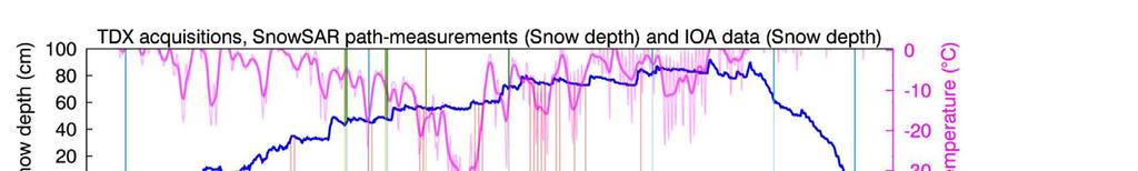
5 Sodankylae 2012: Repeat pass coherence ( t = 11 d) May Oct. 01 Oct. 12 Oct. 23 Nov. 03 Nov. 14 Nov. 25 Dec. 06 Dec 17 Dec. 28 Jan. 08 Jan th +3 C, no snow Accumulating snow C accumulation wet / melting Meadows and frozen wetland: low coherence snowing or melting. Further interpretation (RVoG, etc. ) difficult due to temp. 30th stable weather Feb. 10 Feb. 21 Mar. 03 Mar. 14 Mar. 25 Apr. 05 Apr. 16 Apr. 27 May 08 May 19 30th +20 cm snow +10 cm snow +10 cm snow cold stable weather, snow depth: 80 cm Setting Melting No snow left, +10 C 5

6 Polarimetric Phase Difference (PPD) c = VV HH (co polar) What about this: c =??? Is there any signature of snow? Snow as a layered structure? c = 0 c = <0> c = ±180 c = X c = w 1 X + w rough surface: distribution around zero. (dihedral reflection, HH VV ) X: random, uniform distribution (random volume) (mixture) 6


7 Snow is structures as layers. Microwaves reflections at layers are confirmed by the Swiss Institute for Snow and Avalanche Research (SLF). =??? c 60 cm 7 Ice layers in a block of wind compressed snow
: c = VV HH (co polar) Nov 04 Jan 03 Jan 03 Jan 09 Jan 14 Jan 14 Jan 25 Feb 16 March 26 April 28 May 20")
8 co polar PPD over the winter average PPD c > Ground campaigns: Ground campaign TSX / TDX dual pol data (HH, VV): c = VV HH (co polar) Nov 04 Jan 03 Jan 03 Jan 09 Jan 14 Jan 14 Jan 25 Feb 16 March 26 April 28 May 20 8
 Measure snow")
 Classification: no")
 Calculate PPD: c =")


9 Ground truth vs. PPD c 1) Measure snow depth in the field. 2) Classification: no Forest / Forest. 3) Calculate PPD: c = VV HH 4) Compare PPD with snow depth. 5) Plot correlations for acquisitions. 0.5 normalized intensity 9

10 Acquisition date: 03 Jan 2012, orbit 32 Ground data takes: 9th + 10th Jan, 2012 Correlation between snow height and Polarimetric phase difference VV HH for forested and not forested areas. backscatter and snow tracks 10


11 Acquisition date: 03 Jan 2012, orbit 39 Ground data takes: 9th + 10th Jan, 2012 Correlation between snow height and Polarimetric phase difference VV HH for forested and not forested areas. backscatter and snow tracks 11


12 Correlation between snow depth and PPD VV HH. Acquisition date: 09 Jan 2012, orbit 130 aoi = 32.7 Ground data takes: 9th + 10th Jan, 2012 backscatter and snow tracks 12

13 Correlation between snow depth and PPD VV HH. Acquisition date: 14 Jan 2012, orbit 39 aoi = 39.7 Ground data takes: 9th + 10th Jan, 2012 backscatter and snow tracks 13


14 Correlation between snow depth and PPD VV HH. Acquisition date: 14 Jan 2012, orbit 32 aoi = 41.5 Ground data takes: 9th + 10th Jan, 2012 backscatter and snow tracks 14


15 Correlation between snow depth and PPD VV HH. Acquisition date: 25 Jan 2012, orbit 32 aoi = 41.5 Ground data takes: 23 th + 24 th Jan, 2012 backscatter and snow tracks 15
 Acquisition date: 16 Feb 2012, orbit 39 aoi = 39.")
16 Correlation between snow depth and PPD VV HH. Extrem increase of temperature. +20 cm of fresh humid snow. > no layers visible. (small penetration.) Acquisition date: 16 Feb 2012, orbit 39 aoi = 39.7 Ground data takes: 7th 9th Feb, nd 26th Feb, 2012 (heavy snowfall between campaign and acquisition) backscatter and snow tracks 16


17 Correlation between snow depth and PPD VV HH. frequent humid snow fall, 0 C. only a few layers visible. penetration only in top layer. Acquisition date: 26 March 2012, orbit 130 aoi = 32.7 Ground data takes: 23rd March, 2012 backscatter and snow tracks 17
18 18
19 Why is Snow depth proportional to ( VV HH )? Suggestions: 1. Propagation speed differs for HH and VV. 2. Different penetration depth for HH and VV. 3. Linear combination of phase jumps at different layers. #2 is supported by different Fresnel coefficients at snow layers for polarizations. n 0 n 1 R VV,1, R HH,1 HH E VV E VV HH n 2 n j R VV,2, R HH,2 Summ of all scattering components has a non zero phase difference: VV HH. 19
20 Conclusion Repeat pass InSAR: Snowfall and melting events cause strong decorrelation of repeat pass Interferometric coherence. > Microwave interaction with snow layer! Polarimetry: Clear evidence for correlation between PPD VV HH and snow over open area. (Volume scattering in forests destroys a clear phase signal). Model is under developement and ideas area welcome! Churchill: 2011/2012 Special thanks to FMI, Enveo, Gamma Remote Sensing, EC, NASA JPL, WSL SLF for ground campaigns. Distributed measurements make incomparably better validations possible than fixed stations.
21 21
22 Spatial comparison of snow depth along transect with PPD. Co polar phase difference c follows the snow depth along the transect. 22


23 Sodankylae Google Earth view TerraSAR X Dr. Chris Derksen (EC) Mark Dixon (NASA) Fotos from NOSREX III ground campaign, Backscatter signal 0 Courtesy to ARC FMI 23 Student participating in the campaign via FMI. 23
24 Change detection by coherence decay: 11 d 22 d 33 d 44 d Strong temporal decorrelation in X band caused by Snowfall, melting or strong wind drift For each point the coherences of at least 8 scenes of the same testsite were averaged. Decay time of coherence: t 1/2 = 4.2 days. Repeat times of a few days are favourable. 24

25 Decay of coherence for X band TSX data Decay time of Coherence: t 1/2 = 4.2 days > Very valuable if repeat times of a few days are possible. For each point 8 or more scenes of the same testsite were used and the coherences values calculated from each scene were averaged. The red line is a fitted exponential.


26 Differential InSAR: Local phase patterns due to freezing? Local phase pattern correlate with freezing structures on the ground. Up/down lift by freezing/thawing cycles? 26
 e f(z): Vertical reflectivity function = backscattered radiation per depth volume.")

27 InSAR: Random Volume over Ground Model ~ Vol f ( z) Expected volume coherence. e i z z o h v o f ( z) e f(z): Vertical reflectivity function = backscattered radiation per depth volume. h v o i z z f ( z)dz dz f(z) f(z) 2 Layer Scattering Model Random Volume Realistic reflectivity function / modelled reflectivity function for a snow pack. Z E 1 E 2 Ground Expected coherence for homogeneous snow layer over ground: Good sensitivity to snow volume can be archived for z = ~2...7 m -1 corresponding to baselines of Acq. 1 b = km -> terrasar-x (h = 514 km) b = m -> airplane (h AGL =2.5 km) b = m -> airplane ( h AGL =1.5 km)

28 Baseline overview for TanDEM X


29 DEM generation with TDX DEM Rottenbach, Tueringen Germany. (Thanks to Nicolas for the data) > gap filling algorithm 29


30 Generation of a DEM DEM Corrected DEM not corrected 30
")


 06 Oct 2011")


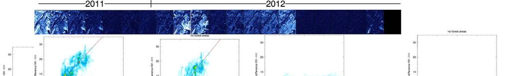
31 TanDEM X Pol InSAR: DEM(VV) vs. DEM(HH) Coherence Interferometric HH VV phase difference (HH) (VV) 06 Oct Oct Oct Nov Nov Dec Dec Jan


 (50 between x 30 px")
.")
32 Polarimetry: Phase differences VV HH Values < 0.4 are masked and set to the average phase difference. Is there a relation between VV HH and snow? Validation not possible due to lack of ground data! Polarimetric Absolut Color: value Phase phase of coherence differences (VV,HH) (50 between x 30 px with smoothing HH a and 7 x 9 VV pxwindow) (50 window. x 30 px window). Brightness: Absolut value of coherence (7x9 px window).


 VV(t)")


33 TanDEM X: Double D InSAR Phase difference VV(t+11) HH(t+11) VV(t) HH(t) Coherence HH VV 06 Oct Oct Oct Nov Nov 2011 Differential complex coherence HH (t) VV(t+11) ** VV HH(t) 11 Dec Dec Jan

")

34 Abs_coherence complex interferogram. ( interferogram) Interferometry data churchill 2010/ /
Model based forest height estimation with ALOS/PalSAR: A first study.
 Model based forest height estimation with ALOS/PalSAR: A first study. K.P. Papathanassiou*, I. Hajnsek*, T.Mette*, S.R. Cloude** and A. Moreira* * (DLR) (DLR-HR) Oberpfaffenhofen, Germany ** AEL Consultants
Making a case for full-polarimetric radar remote sensing
 Making a case for full-polarimetric radar remote sensing Jeremy Nicoll Alaska Satellite Facility, University of Alaska Fairbanks 1 Polarization States of a Coherent Plane Wave electric field vector vertically
ERS-ENVISAT CROSS-INTERFEROMETRY SIGNATURES OVER DESERTS. Urs Wegmüller, Maurizio Santoro and Christian Mätzler
 ERS-ENVISAT CROSS-INTERFEROMETRY SIGNATURES OVER DESERTS Urs Wegmüller, Maurizio Santoro and Christian Mätzler Gamma Remote Sensing AG, Worbstrasse 225, CH-3073 Gümligen, Switzerland, http://www.gamma-rs.ch,
SNOW MASS RETRIEVAL BY MEANS OF SAR INTERFEROMETRY
 SNOW MASS RETRIEVAL BY MEANS OF SAR INTERFEROMETRY Helmut Rott (1), Thomas Nagler (1), Rolf Scheiber (2) (1) ENVEO, Environmental Earth Observation OEG, Exlgasse 39, A-6020 Innsbruck, Austria E-mail: Helmut.Rott@enveo.at
DLR s TerraSAR-X contributes to international fleet of radar satellites to map the Arctic and Antarctica
 DLR s TerraSAR-X contributes to international fleet of radar satellites to map the Arctic and Antarctica The polar regions play an important role in the Earth system. The snow and ice covered ocean and
Wave Propagation Model for Coherent Scattering from a Randomly Distributed Target
 Wave Propagation Model for Coherent Scattering from a Randomly Distributed Target Don Atwood,Ben Matthiss, Liza Jenkins, Shimon Wdowinski, Sang Hoon Hong, and Batuhan Osmanoglu Outline Requirements for
SAR Coordination for Snow Products
 Polar SAR Coordination Working Meeting 5 SAR Coordination for Snow Products David Small 1, Thomas Nagler 2, David Jäger 1, Christoph Rohner 1, Adrian Schubert 1 1: University of Zurich, Switzerland 2:
Multi- Sensor Ground- based Microwave Snow Experiment at Altay, CHINA
 Multi- Sensor Ground- based Microwave Snow Experiment at Altay, CHINA Jiancheng Shi 1, Chuan Xiong 1, Jinmei Pan 1, Tao Che 2, Tianjie Zhao 1, Haokui Xu 1, Lu Hu 1, Xiang Ji 1, Shunli Chang 3, Suhong Liu
Soil moisture retrieval over periodic surfaces using PolSAR data
 Soil moisture retrieval over periodic surfaces using PolSAR data Sandrine DANIEL Sophie ALLAIN Laurent FERRO-FAMIL Eric POTTIER IETR Laboratory, UMR CNRS 6164, University of Rennes1, France Contents Soil
CHAPTER-7 INTERFEROMETRIC ANALYSIS OF SPACEBORNE ENVISAT-ASAR DATA FOR VEGETATION CLASSIFICATION
 147 CHAPTER-7 INTERFEROMETRIC ANALYSIS OF SPACEBORNE ENVISAT-ASAR DATA FOR VEGETATION CLASSIFICATION 7.1 INTRODUCTION: Interferometric synthetic aperture radar (InSAR) is a rapidly evolving SAR remote
Monitoring Sea Ice with Space-borne Synthetic Aperture Radar
 Monitoring Sea Ice with Space-borne Synthetic Aperture Radar Torbjørn Eltoft UiT- the Arctic University of Norway CIRFA A Centre for Research-based Innovation cirfa.uit.no Sea ice & climate Some basic
Airborne Holographic SAR Tomography at L- and P-band
 Airborne Holographic SAR Tomography at L- and P-band O. Ponce, A. Reigber and A. Moreira. Microwaves and Radar Institute (HR), German Aerospace Center (DLR). 1 Outline Introduction to 3-D SAR Holographic
Analysis of the Temporal Behavior of Coherent Scatterers (CSs) in ALOS PalSAR Data
 in ALOS PalSAR Data") Analysis of the Temporal Behavior of Coherent Scatterers (CSs) in ALOS PalSAR Data L. Marotti, R. Zandona-Schneider & K.P. Papathanassiou German Aerospace Center (DLR) Microwaves and Radar Institute0 PO.BOX
Analysis of the Temporal Behavior of Coherent Scatterers (CSs) in ALOS PalSAR Data L. Marotti, R. Zandona-Schneider & K.P. Papathanassiou German Aerospace Center (DLR) Microwaves and Radar Institute0 PO.BOX
Snow Water Equivalent (SWE) of dry snow derived from InSAR -theory and results from ERS Tandem SAR data
 of dry snow derived from InSAR -theory and results from ERS Tandem SAR data") Snow Water Equivalent (SWE) of dry snow derived from InSAR -theory and results from ERS Tandem SAR data Tore Guneriussen, Kjell Arild Høgda, Harald Johnsen and Inge Lauknes NORUT IT Ltd., Tromsø Science
Snow Water Equivalent (SWE) of dry snow derived from InSAR -theory and results from ERS Tandem SAR data Tore Guneriussen, Kjell Arild Høgda, Harald Johnsen and Inge Lauknes NORUT IT Ltd., Tromsø Science
GLOBAL FOREST CLASSIFICATION FROM TANDEM-X INTERFEROMETRIC DATA: POTENTIALS AND FIRST RESULTS
 GLOBAL FOREST CLASSIFICATION FROM TANDEM-X INTERFEROMETRIC DATA: POTENTIALS AND FIRST RESULTS Michele Martone, Paola Rizzoli, Benjamin Bräutigam, Gerhard Krieger Microwaves and Radar Institute German Aerospace
Evaluation of sub-kilometric numerical simulations of C-band radar backscatter over the french Alps against Sentinel-1 observations
 Evaluation of sub-kilometric numerical simulations of C-band radar backscatter over the french Alps against Sentinel-1 observations Gaëlle Veyssière, Fatima Karbou, Samuel Morin, Matthieu Lafaysse Monterey,
RADAR Remote Sensing Application Examples
 RADAR Remote Sensing Application Examples! All-weather capability: Microwave penetrates clouds! Construction of short-interval time series through cloud cover - crop-growth cycle! Roughness - Land cover,
The Importance of Microwave Remote Sensing for Operational Sea Ice Services And Challenges
 The Importance of Microwave Remote Sensing for Operational Sea Ice Services And Challenges Wolfgang Dierking January 2015 (1) Why is microwave remote sensing important (=useful) for sea ice mapping? Problems
INTRODUCTION TO MICROWAVE REMOTE SENSING. Dr. A. Bhattacharya
 1 INTRODUCTION TO MICROWAVE REMOTE SENSING Dr. A. Bhattacharya Why Microwaves? More difficult than with optical imaging because the technology is more complicated and the image data recorded is more varied.
Tandem-L: A Mission Proposal for Monitoring Dynamic Earth Processes
 Tandem-L: A Mission Proposal for Monitoring Dynamic Earth Processes A. Moreira, G. Krieger, M. Younis, I. Hajnsek, K. Papathanassiou, M. Eineder, P. Dekker, F. De Zan German Aerospace Center (DLR) Dynamic
Application of Sentinel-1 SAR for monitoring surface velocity of Greenland outlet glaciers
 pplication of Sentinel-1 SR for monitoring surface velocity of Greenland outlet glaciers Thomas Nagler, Markus Hetzenecker, Helmut Rott and Jan Wuite ENVEO IT GmbH Fringe 2015 OUTLINE Ice Surface Velocity
Feasibility of snow water equivalent retrieval by means of interferometric ALOS PALSAR data
 Feasibility of snow water equivalent retrieval by means of interferometric ALOS PALSAR data, Florian Müller, Helmut Rott, and Markus Heidinger ENVEO Technikerstrasse 21a, A 6020 Innsbruck, Austria www.galahad-euproject.org
Fulong Chen Nicola Masini, Jie Liu, Jiangbin You, Rosa Lasaponara MAEIC
 Archaeological prospection in the Western Regions of Western Han Dynasty by satellite synthetic aperture radar data, case studies of Yumen Frontier Pass and Niya ruins Fulong Chen chenfl@radi.ac.cn Nicola
An Introduction to PolSAR-Ap: Exploitation of Fully Polarimetric SAR Data for Application Demonstration
 An Introduction to PolSAR-Ap: Exploitation of Fully Polarimetric SAR Data for Application Demonstration Irena Hajnsek, Matteo Pardini, Kostas Papathanassiou, Shane Cloude, Juan M. Lopez-Sanchez, David
K&C Phase 4 Status report. Use of short-period ALOS-2 observations for vegetation characterization and classification
 K&C Phase 4 Status report Use of short-period ALOS-2 observations for vegetation characterization and classification Paul Siqueira University of Massachusetts, Amherst Science Team meeting #22 Tokyo, Japan,
IEEE GEOSCIENCE AND REMOTE SENSING LETTERS, VOL. 1, NO. 2, APRIL
 IEEE GEOSCIENCE AND REMOTE SENSING LETTERS, VOL. 1, NO. 2, APRIL 2004 57 Delta-K Interferometric SAR Technique for Snow Water Equivalent (SWE) Retrieval Geir Engen, Tore Guneriussen, and Øyvind Overrein
EE/Ge 157 b. Week 2. Polarimetric Synthetic Aperture Radar (2)
") EE/Ge 157 b Week 2 Polarimetric Synthetic Aperture Radar (2) COORDINATE SYSTEMS All matrices and vectors shown in this package are measured using the backscatter alignment coordinate system. This system
EE/Ge 157 b Week 2 Polarimetric Synthetic Aperture Radar (2) COORDINATE SYSTEMS All matrices and vectors shown in this package are measured using the backscatter alignment coordinate system. This system
ALOS PI Symposium 2009, 9-13 Nov 2009 Hawaii MOTION MONITORING FOR ETNA USING ALOS PALSAR TIME SERIES
 ALOS PI Symposium 2009, 9-13 Nov 2009 Hawaii ALOS Data Nodes: ALOS RA-094 and RA-175 (JAXA) MOTION MONITORING FOR ETNA USING ALOS PALSAR TIME SERIES Urs Wegmüller, Charles Werner and Maurizio Santoro Gamma
Ice Observations on the Churchill River using Satellite Imagery
 CGU HS Committee on River Ice Processes and the Environment 15 th Workshop on River Ice St. John s, Newfoundland and Labrador, June 15-17, 2009 Ice Observations on the Churchill River using Satellite Imagery
Multi-temporal archaeological and environmental prospection in Nasca (Peru) with ERS-1/2, ENVISAT and Sentinel-1A C-band SAR data
 with ERS-1/2, ENVISAT and Sentinel-1A C-band SAR data") 12-13 November 215 ESA-ESRIN, Frascati (Rome), Italy Day 1 Session: Historical Landscapes and Environmental Analysis Multi-temporal archaeological and environmental prospection in Nasca (Peru) with ERS-1/2,
12-13 November 215 ESA-ESRIN, Frascati (Rome), Italy Day 1 Session: Historical Landscapes and Environmental Analysis Multi-temporal archaeological and environmental prospection in Nasca (Peru) with ERS-1/2,
The Potential of High Resolution Satellite Interferometry for Monitoring Enhanced Oil Recovery
 The Potential of High Resolution Satellite Interferometry for Monitoring Enhanced Oil Recovery Urs Wegmüller a Lutz Petrat b Karsten Zimmermann c Issa al Quseimi d 1 Introduction Over the last years land
Microwave Remote Sensing of Soil Moisture. Y.S. Rao CSRE, IIT, Bombay
 Microwave Remote Sensing of Soil Moisture Y.S. Rao CSRE, IIT, Bombay Soil Moisture (SM) Agriculture Hydrology Meteorology Measurement Techniques Survey of methods for soil moisture determination, Water
ESA GlobSnow - project overview
 ESA GlobSnow - project overview GCW 1 st Implementation meeting Geneve, 23 Nov. 2011 K. Luojus & J. Pulliainen (FMI) + R. Solberg (NR) Finnish Meteorological Institute 1.12.2011 1 ESA GlobSnow ESA-GlobSnow
Studies of Austfonna ice cap (Svalbard) using radar altimetry with other satellite techniques
 using radar altimetry with other satellite techniques") 15 Years of progress in Radar Altimetry Symposium Ocean surface topography science team (OSTST) International Doris Service (IDS) Workshop, Argo Workshop 13-18 March 2006, Venice, Italy Alexei V. Kouraev,
15 Years of progress in Radar Altimetry Symposium Ocean surface topography science team (OSTST) International Doris Service (IDS) Workshop, Argo Workshop 13-18 March 2006, Venice, Italy Alexei V. Kouraev,
Monitoring the ice cover evolution of a medium size river from RADARSAT-1 : preliminary results
 Monitoring the ice cover evolution of a medium size river from RADARSAT-1 : preliminary results Y. Gauthier, T. B.M.J. Ouarda, M. Bernier and A. El Battay INRS-Eau, 2800 Einstein, C.P. 7500, Ste-Foy (Qc)
K&C Phase 4 Status report. Use of short-period ALOS-2 observations for vegetation characterization and classification
 K&C Phase 4 Status report Use of short-period ALOS-2 observations for vegetation characterization and classification Paul Siqueira, Tracy Whelen University of Massachusetts, Amherst Yang Lei NASA JPL Science
TEMPORAL VARIABILITY OF ICE FLOW ON HOFSJÖKULL, ICELAND, OBSERVED BY ERS SAR INTERFEROMETRY
 TEMPORAL VARIABILITY OF ICE FLOW ON HOFSJÖKULL, ICELAND, OBSERVED BY ERS SAR INTERFEROMETRY Florian Müller (1), Helmut Rott (2) (1) ENVEO IT, Environmental Earth Observation GmbH, Technikerstrasse 21a,
Global SWE Mapping by Combining Passive and Active Microwave Data: The GlobSnow Approach and CoReH 2 O
 Global SWE Mapping by Combining Passive and Active Microwave Data: The GlobSnow Approach and CoReH 2 O April 28, 2010 J. Pulliainen, J. Lemmetyinen, A. Kontu, M. Takala, K. Luojus, K. Rautiainen, A.N.
1. Regarding the availability of two co-polarized (HH and VV) channels.
 channels.") Dear Anonymous Referee #2, Thank you for your insightful and stimulating review comments. Modifications based on these comments will significantly improve the quality of this research paper. General Comments:
Dear Anonymous Referee #2, Thank you for your insightful and stimulating review comments. Modifications based on these comments will significantly improve the quality of this research paper. General Comments:
CLIMATE CHANGE AND REGIONAL HYDROLOGY ACROSS THE NORTHEAST US: Evidence of Changes, Model Projections, and Remote Sensing Approaches
 CLIMATE CHANGE AND REGIONAL HYDROLOGY ACROSS THE NORTHEAST US: Evidence of Changes, Model Projections, and Remote Sensing Approaches Michael A. Rawlins Dept of Geosciences University of Massachusetts OUTLINE
CHARACTERISTICS OF SNOW AND ICE MORPHOLOGICAL FEATURES DERIVED FROM MULTI-POLARIZATION TERRASAR-X DATA
 CHARACTERISTICS OF SNOW AND ICE MORPHOLOGICAL FEATURES DERIVED FROM MULTI-POLARIZATION TERRASAR-X DATA Dana Floricioiu 1, Helmut Rott 2, Thomas Nagler 2, Markus Heidinger 2 and Michael Eineder 1 1 DLR,
K&C Phase 4 Status report. Ice Sheet Monitoring using ALOS-2. University of California, Irvine 2 JPL
 K&C Phase 4 Status report Ice Sheet Monitoring using ALOS-2 Bernd Scheuchl 1, Jeremie Mouginot 1, Eric Rignot 1,2 1 University of California, Irvine 2 JPL Science Team meeting #24 Tokyo, Japan, January
Radar Remote Sensing: Monitoring Ground Deformations and Geohazards from Space
 Radar Remote Sensing: Monitoring Ground Deformations and Geohazards from Space Xiaoli Ding Department of Land Surveying and Geo-Informatics The Hong Kong Polytechnic University A Question 100 km 100 km
Dual-Frequency Ku- Band Radar Mission Concept for Snow Mass
 Dual-Frequency Ku- Band Radar Mission Concept for Snow Mass Chris Derksen Environment and Climate Change Canada Study Team: Climate Research Division/Meteorological Research Division, ECCC Canadian Space
Microwave emissivity of land surfaces: experiments and models
 Microwave emissivity of land surfaces: experiments and models M. Brogioni, G.Macelloni, S.Paloscia, P.Pampaloni, S.Pettinato, E.Santi IFAC-CNR Florence, Italy Introduction Experimental investigations conducted
Improved PSI Performance for Landslide Monitoring Applications. J. Duro, R. Iglesias, P. Blanco-Sánchez, F. Sánchez and D. Albiol
 Improved PSI Performance for Landslide Monitoring Applications J. Duro, R. Iglesias, P. Blanco-Sánchez, F. Sánchez and D. Albiol Outline Area of Study Previous PSI (and others) studies Main conclusions
FMI Arctic Space Centre. Jyri Heilimo Finnish Meteorological Institute
 FMI Arctic Space Centre Jyri Heilimo Finnish Meteorological Institute FMI - Arctic Space Center Studies of atmospheric phenomena and their interaction with biosphere and cryosphere in high latitudes Hydrology,
POLARIMETRY-BASED LAND COVER CLASSIFICATION WITH SENTINEL-1 DATA
 POLARIMETRY-BASED LAND COVER CLASSIFICATION WITH SENTINEL-1 DATA Xavier Banqué (1), Juan M Lopez-Sanchez (2), Daniel Monells (1), David Ballester (2), Javier Duro (1), Fifame Koudogbo (1) (1) Altamira
Meteorological Satellite Image Interpretations, Part III. Acknowledgement: Dr. S. Kidder at Colorado State Univ.
 Meteorological Satellite Image Interpretations, Part III Acknowledgement: Dr. S. Kidder at Colorado State Univ. Dates EAS417 Topics Jan 30 Introduction & Matlab tutorial Feb 1 Satellite orbits & navigation
Remote sensing of sea ice
 Remote sensing of sea ice Ice concentration/extent Age/type Drift Melting Thickness Christian Haas Remote Sensing Methods Passive: senses shortwave (visible), thermal (infrared) or microwave radiation
Retrieving 3D deformation pattern of a landslide with hiresolution InSAR and in-situ measurements: Just landslide case-study
 Retrieving 3D deformation pattern of a landslide with hiresolution InSAR and in-situ measurements: Just landslide case-study Zbigniew Perski (1), Petar Marinković (2), Yngvar Larsen (3), Tomasz Wojciechowski
DIFFERENTIAL INSAR STUDIES IN THE BOREAL FOREST ZONE IN FINLAND
 DIFFERENTIAL INSAR STUDIES IN THE BOREAL FOREST ZONE IN FINLAND Kirsi Karila (1,2), Mika Karjalainen (1), Juha Hyyppä (1) (1) Finnish Geodetic Institute, P.O. Box 15, FIN-02431 Masala, Finland, Email:
SENTINEL 1 Mission status and contribution to PSTG
 PSTG SAR WG meeting, 12 September 2016, ESTEC SENTINEL 1 Mission status and contribution to PSTG First Sentinel1B Images 28 April 2016 Sentinel-1B Launch from Kourou, 25 April 2016 Sentinel 1 Mission Operations
GEOGG141 Principles & Practice of Remote Sensing (PPRS) RADAR III: Applications Revision
 RADAR III: Applications Revision") UCL DEPARTMENT OF GEOGRAPHY GEOGG141 Principles & Practice of Remote Sensing (PPRS) RADAR III: Applications Revision Dr. Mathias (Mat) Disney UCL Geography Office: 113, Pearson Building Tel: 7670 0592
UCL DEPARTMENT OF GEOGRAPHY GEOGG141 Principles & Practice of Remote Sensing (PPRS) RADAR III: Applications Revision Dr. Mathias (Mat) Disney UCL Geography Office: 113, Pearson Building Tel: 7670 0592
Retrieving Snowfall Rate with Satellite Passive Microwave Measurements
 Retrieving Snowfall Rate with Satellite Passive Microwave Measurements Huan Meng 1, Ralph Ferraro 1, Banghua Yan 1, Cezar Kongoli 2, Nai-Yu Wang 2, Jun Dong 2, Limin Zhao 1 1 NOAA/NESDIS, USA 2 Earth System
ADVANCEMENTS IN SNOW MONITORING
 Polar Space Task Group ADVANCEMENTS IN SNOW MONITORING Thomas Nagler, ENVEO IT GmbH, Innsbruck, Austria Outline Towards a pan-european Multi-sensor Snow Product SnowPEx Summary Upcoming activities SEOM
DUAL-POLARIZED COSMO SKYMED SAR DATA TO OBSERVE METALLIC TARGETS AT SEA
 DUAL-POLARIZED COSMO SKYMED SAR DATA TO OBSERVE METALLIC TARGETS AT SEA F. Nunziata, M. Montuori and M. Migliaccio Università degli Studi di Napoli Parthenope Dipartimento per le Tecnologie Centro Direzionale,
EasyChair Preprint. Height Accuracy and Data Coverage for the Final Global TanDEM-X DEM Data
 EasyChair Preprint 123 Height Accuracy and Data Coverage for the Final Global TanDEM-X DEM Data Christopher Wecklich, Carolina Gonzalez and Paola Rizzoli EasyChair preprints are intended for rapid dissemination
Advancing Remote-Sensing Methods for Monitoring Geophysical Parameters
 Advancing Remote-Sensing Methods for Monitoring Geophysical Parameters Christian Mätzler (Retired from University of Bern) Now consultant for Gamma Remote Sensing, Switzerland matzler@iap.unibe.ch TERENO
General Four-Component Scattering Power Decomposition with Unitary Transformation of Coherency Matrix
 1 General Four-Component Scattering Power Decomposition with Unitary Transformation of Coherency Matrix Gulab Singh, Member, IEEE, Yoshio Yamaguchi, Fellow, IEEE and Sang-Eun Park, Member, IEEE Abstract
A Preliminary Severe Winter Storms Climatology for Missouri from
 A Preliminary Severe Winter Storms Climatology for Missouri from 1960-2010 K.L. Crandall and P.S Market University of Missouri Department of Soil, Environmental and Atmospheric Sciences Introduction The
Radar observations of seasonal snow in an agricultural field in S. Ontario during the winter season
 Radar observations of seasonal snow in an agricultural field in S. Ontario during the 213-214 winter season Aaron Thompson, Richard Kelly and Andrew Kasurak Interdisciplinary Centre on Climate Change and
Passive Microwave Physics & Basics. Edward Kim NASA/GSFC
 Passive Microwave Physics & Basics Edward Kim NASA/GSFC ed.kim@nasa.gov NASA Snow Remote Sensing Workshop, Boulder CO, Aug 14 16, 2013 1 Contents How does passive microwave sensing of snow work? What are
Soil frost from microwave data. Kimmo Rautiainen, Jouni Pulliainen, Juha Lemmetyinen, Jaakko Ikonen, Mika Aurela
 Soil frost from microwave data Kimmo Rautiainen, Jouni Pulliainen, Juha Lemmetyinen, Jaakko Ikonen, Mika Aurela Why landscape freeze/thaw? Latitudinal variation in mean correlations (r) between annual
Analysis of High Resolution Multi-frequency, Multipolarimetric and Interferometric Airborne SAR Data for Hydrologic Model Parameterization
 Analysis of High Resolution Multi-frequency, Multipolarimetric and Interferometric Airborne SAR Data for Hydrologic Model Parameterization Martin Herold 1, Volker Hochschild 2 1 Remote Sensing Research
Regional influence on road slipperiness during winter precipitation events. Marie Eriksson and Sven Lindqvist
 Regional influence on road slipperiness during winter precipitation events Marie Eriksson and Sven Lindqvist Physical Geography, Department of Earth Sciences, Göteborg University Box 460, SE-405 30 Göteborg,
SAR interferometry Status and future directions. Rüdiger Gens
 SAR interferometry Status and future directions Rüdiger Gens Polarimetric InSAR Polarimetric InSAR InSAR - Status and future directions sensitivity to changes in surface scattering, even in the presence
Remote Sensing of SWE in Canada
 Remote Sensing of SWE in Canada Anne Walker Climate Research Division, Environment Canada Polar Snowfall Hydrology Mission Workshop, June 26-28, 2007 Satellite Remote Sensing Snow Cover Optical -- Snow
2 nd Asia CryoNet Workshop Current methods of measurement of the cryosphere in Asia consistency and issues
 2 nd Asia CryoNet Workshop Current methods of measurement of the cryosphere in Asia consistency and issues Dongqi Zhang, Cunde Xiao, Vladimir Aizen and Wolfgang Schöner Feb.5, 2016, Salekhard, Russia 1.
Interannual variation of MODIS NDVI in Lake Taihu and its relation to climate in submerged macrophyte region
 Yale-NUIST Center on Atmospheric Environment Interannual variation of MODIS NDVI in Lake Taihu and its relation to climate in submerged macrophyte region ZhangZhen 2015.07.10 1 Outline Introduction Data
Climate Change and Arizona s Rangelands: Management Challenges and Opportunities
 Climate Change and Arizona s Rangelands: Management Challenges and Opportunities Mike Crimmins Climate Science Extension Specialist Dept. of Soil, Water, & Env. Science & Arizona Cooperative Extension
STUDIES OF OCEAN S SCATTERING PROPERTIES BASED ON AIRSAR DATA
 STUDIES OF OCEAN S SCATTERING PROPERTIES BASED ON AIRSAR DATA Wang Wenguang *, Sun Jinping, Wang Jun, Hu Rui School of EIE, Beihang University, Beijing 00083, China- wwenguang@ee.buaa.edu.cn KEY WORDS:
Characterization of Snow Facies on the Greenland Ice Sheet Observed by TanDEM-X Interferometric SAR Data
 Article Characterization of Snow Facies on the Greenland Ice Sheet Observed by TanDEM-X Interferometric SAR Data Paola Rizzoli 1, *, Michele Martone 1, Helmut Rott 2,3 and Alberto Moreira 1 1 German Aerospace
LAND COVER CLASSIFICATION BASED ON SAR DATA IN SOUTHEAST CHINA
 LAND COVER CLASSIFICATION BASED ON SAR DATA IN SOUTHEAST CHINA Mr. Feilong Ling, Dr. Xiaoqin Wang, Mr.Xiaoming Shi Fuzhou University, Level 13, Science Building,No.53 Gongye Rd., 35, Fuzhou, China Email:
Helsinki Testbed - a contribution to NASA's Global Precipitation Measurement (GPM) mission
 mission") Helsinki Testbed - a contribution to NASA's Global Precipitation Measurement (GPM) mission Ubicasting workshop, September 10, 2008 Jarkko Koskinen, Jarmo Koistinen, Jouni Pulliainen, Elena Saltikoff, David
Helsinki Testbed - a contribution to NASA's Global Precipitation Measurement (GPM) mission Ubicasting workshop, September 10, 2008 Jarkko Koskinen, Jarmo Koistinen, Jouni Pulliainen, Elena Saltikoff, David
Snow on sea ice retrieval using microwave radiometer data. Rasmus Tonboe and Lise Kilic Danish Meteorological Institute Observatoire de Paris
 Snow on sea ice retrieval using microwave radiometer data Rasmus Tonboe and Lise Kilic Danish Meteorological Institute Observatoire de Paris We know something about snow The temperature gradient within
DLR/TerraSAR-X: development of IPY portofolio since the SAR coordination workshop (CSA, March 2008) Dana Floricioiu
 Dana Floricioiu") DLR/TerraSAR-X: development of IPY portofolio since the SAR coordination workshop (CSA, March 2008) Dana Floricioiu STG-3 Meeting, ESRIN Frascati 5/6 May 2008 Acquisitions themes adopted at the SAR coordination
DLR/TerraSAR-X: development of IPY portofolio since the SAR coordination workshop (CSA, March 2008) Dana Floricioiu STG-3 Meeting, ESRIN Frascati 5/6 May 2008 Acquisitions themes adopted at the SAR coordination
A High Elevation Climate Monitoring Network
 A High Elevation Climate Monitoring Network Kelly T. Redmond Western Regional Climate Center Desert Research Institute Reno Nevada AGU San Francisco WRCC / OSU Nevada Precip-Elevation Distribution 100%
Radar mapping of snow melt over mountain glaciers in High Mountain Asia Mentor: Tarendra Lakhankar Collaborators: Nir Krakauer, Kyle MacDonald and
 Radar mapping of snow melt over mountain glaciers in High Mountain Asia Mentor: Tarendra Lakhankar Collaborators: Nir Krakauer, Kyle MacDonald and Nick Steiner How are Glaciers Formed? Glaciers are formed
MULTI-POLARISATION MEASUREMENTS OF SNOW SIGNATURES WITH AIR- AND SATELLITEBORNE SAR
 EARSeL eproceedings 5, 1/2006 111 MULTI-POLARISATION MEASUREMENTS OF SNOW SIGNATURES WITH AIR- AND SATELLITEBORNE SAR Eirik Malnes 1, Rune Storvold 1, Inge Lauknes 1 and Simone Pettinato 2 1. Norut IT,
SAR data Sensords and examples
 SAR data Sensords and examples Sar Technical Training for Forest Mapping 2014/2015 Cédric Lardeux Jean-Paul Rudant Pierre-Louis Frison cedric.lardeux@onfinternational.com rudant@univ-mlv.fr frison@univ-mlv.fr
Interpretation of Polar-orbiting Satellite Observations. Atmospheric Instrumentation
 Interpretation of Polar-orbiting Satellite Observations Outline Polar-Orbiting Observations: Review of Polar-Orbiting Satellite Systems Overview of Currently Active Satellites / Sensors Overview of Sensor
EVALUATION OF CLASSIFICATION METHODS WITH POLARIMETRIC ALOS/PALSAR DATA
 EVALUATION OF CLASSIFICATION METHODS WITH POLARIMETRIC ALOS/PALSAR DATA Anne LÖNNQVIST a, Yrjö RAUSTE a, Heikki AHOLA a, Matthieu MOLINIER a, and Tuomas HÄME a a VTT Technical Research Centre of Finland,
Wave processes in Arctic Seas, observed from TerraSAR-X
 DISTRIBUTION STATEMENT A. Approved for public release; distribution is unlimited. Wave processes in Arctic Seas, observed from TerraSAR-X Susanne Lehner DLR German Air and Space Research Center Earth Observation
Remote Sensing of Snow GEOG 454 / 654
 Remote Sensing of Snow GEOG 454 / 654 What crysopheric questions can RS help to answer? 2 o Where is snow lying? (Snow-covered area or extent) o How much is there? o How rapidly is it melting? (Area, depth,
Investigating Coastal Polynya Thin Sea Ice State in the Laptev Sea Using TerraSAR-X Dual-Pol Stripmap Data
 Investigating Coastal Polynya Thin Sea Ice State in the Laptev Sea Using TerraSAR-X Dual-Pol Stripmap Data Thomas Busche (1), Irena Hajnsek (1), Thomas Krumpen (2), Lasse Rabenstein (2), Jens Hoelemann
Interferometric Synthetic Aperture Radar (InSAR) and GGOS. Andrea Donnellan NASA/JPL February 21, 2007
 and GGOS. Andrea Donnellan NASA/JPL February 21, 2007") Interferometric Synthetic Aperture Radar (InSAR) and GGOS Andrea Donnellan NASA/JPL February 21, 2007 Sources for Science Objectives Fourth component of EarthScope Involvement: NSF, NASA, USGS, Universities
Interferometric Synthetic Aperture Radar (InSAR) and GGOS Andrea Donnellan NASA/JPL February 21, 2007 Sources for Science Objectives Fourth component of EarthScope Involvement: NSF, NASA, USGS, Universities
Julia Figa-Saldaña & Klaus Scipal
 Julia Figa-Saldaña & Klaus Scipal julia.figa@eumetsat.int klaus.scipal@esa.int Meeting, Outline MetOp/EPS status MetOp/EPS Second Generation status 2016 scatterometer conference Other European ocean programme
ERAD Water vapor observations with SAR, microwave radiometer and GPS: comparison of scaling characteristics
 Proceedings of ERAD (2002): 190 194 c Copernicus GmbH 2002 ERAD 2002 Water vapor observations with SAR, microwave radiometer and GPS: comparison of scaling characteristics D. N. Moisseev 1, R. F. Hanssen
Tracking the Climate Of Northern Colorado Nolan Doesken State Climatologist Colorado Climate Center Colorado State University
 Tracking the Climate Of Northern Colorado Nolan Doesken State Climatologist Colorado Climate Center Colorado State University Northern Colorado Business Innovations November 20, 2013 Loveland, Colorado
Intercomparision of snowfall measured by weighing and tipping bucket precipitation gauges at Jumla Airport, Nepal
 Intercomparision of snowfall measured by weighing and tipping bucket precipitation gauges at Jumla Airport, Nepal Department of Hydrology and Meteorology, Nepal Ministry of Environment, Science and Technology
Pol-InSAR Calibration of ESA s BIOMASS Mission
 Pol-InAR Calibration of EA s BIOMA Mission K. Papathanassiou & J-. Kim German Aerospace Center (DLR (DLR-HR biomass Primary Mission Objectives. Reducing the major uncertainties in carbon fluxes linked
Atmospheric Phase Screen (APS) estimation and modeling for radar interferometry
 estimation and modeling for radar interferometry") Atmospheric Phase Screen (APS) estimation and modeling for radar interferometry Ramon Hanssen¹, Alessandro Ferretti², Marco Bianchi², Rossen Grebenitcharsky¹, Frank Kleijer¹, Ayman Elawar¹ ¹ Delft University
Atmospheric Phase Screen (APS) estimation and modeling for radar interferometry Ramon Hanssen¹, Alessandro Ferretti², Marco Bianchi², Rossen Grebenitcharsky¹, Frank Kleijer¹, Ayman Elawar¹ ¹ Delft University
SNOW COVER MONITORING IN ALPINE REGIONS WITH COSMO-SKYMED IMAGES BY USING A MULTITEMPORAL APPROACH AND DEPOLARIZATION RATIO
 SNOW COVER MONITORING IN ALPINE REGIONS WITH COSMO-SKYMED IMAGES BY USING A MULTITEMPORAL APPROACH AND DEPOLARIZATION RATIO B. Ventura 1, T. Schellenberger 1, C. Notarnicola 1, M. Zebisch 1, T. Nagler
SNOW DEPTH AND SURFACE CONDITIONS OF AUSTFONNA ICE CAP (SVALBARD) USING FIELD OBSERVATIONS AND SATELLITE ALTIMETRY
 USING FIELD OBSERVATIONS AND SATELLITE ALTIMETRY") SNOW DEPTH AND SURFACE CONDITIONS OF AUSTFONNA ICE CAP (SVALBARD) USING FIELD OBSERVATIONS AND SATELLITE ALTIMETRY Alexei Kouraev (1,2), Benoît Legrésy (1), Frédérique Rémy (1), Andrea Taurisano (3,4),
SNOW DEPTH AND SURFACE CONDITIONS OF AUSTFONNA ICE CAP (SVALBARD) USING FIELD OBSERVATIONS AND SATELLITE ALTIMETRY Alexei Kouraev (1,2), Benoît Legrésy (1), Frédérique Rémy (1), Andrea Taurisano (3,4),
THE ROLE OF MICROSTRUCTURE IN FORWARD MODELING AND DATA ASSIMILATION SCHEMES: A CASE STUDY IN THE KERN RIVER, SIERRA NEVADA, USA
 MICHAEL DURAND (DURAND.8@OSU.EDU), DONGYUE LI, STEVE MARGULIS Photo: Danielle Perrot THE ROLE OF MICROSTRUCTURE IN FORWARD MODELING AND DATA ASSIMILATION SCHEMES: A CASE STUDY IN THE KERN RIVER, SIERRA
Central Asia Regional Flash Flood Guidance System 4-6 October Hydrologic Research Center A Nonprofit, Public-Benefit Corporation
 http://www.hrcwater.org Central Asia Regional Flash Flood Guidance System 4-6 October 2016 Hydrologic Research Center A Nonprofit, Public-Benefit Corporation FFGS Snow Components Snow Accumulation and
Screening of Earthen Levees using TerraSAR-X Radar Imagery
 Screening of Earthen Levees using TerraSAR-X Radar Imagery James Aanstoos (1), Khaled Hasan (1), Majid Mahrooghy (1), Lalitha Dabbiru (1), Rodrigo Nobrega (1), Saurabh Prasad (1) (1) Geosystems Research
MAPPING OF LAKE ICE IN NORTHERN EUROPE USING DUAL-POLARIZATION RADARSAT-2 DATA
 MAPPING OF LAKE ICE IN NORTHERN EUROPE USING DUAL-POLARIZATION RADARSAT-2 DATA Hindberg, Heidi and Malnes, Eirik Northern Research Institute (Norut), PO Box 6434 Tromsø Science Park, N9291 Tromsø, Email:
Snow Cover Applications: Major Gaps in Current EO Measurement Capabilities
 Snow Cover Applications: Major Gaps in Current EO Measurement Capabilities Thomas NAGLER ENVEO Environmental Earth Observation IT GmbH INNSBRUCK, AUSTRIA Polar and Snow Cover Applications User Requirements