Feasibility of snow water equivalent retrieval by means of interferometric ALOS PALSAR data
|
|
|
- Shon Bradley
- 5 years ago
- Views:
Transcription

1 Feasibility of snow water equivalent retrieval by means of interferometric ALOS PALSAR data, Florian Müller, Helmut Rott, and Markus Heidinger ENVEO Technikerstrasse 21a, A 6020 Innsbruck, Austria
2 Contents Method of SWE Retrieval by InSAR Groundbased InSAR Experiment Coherence Procedure for SWE retrieval from space borne SAR data Examples of PALSAR data Analysis of Alpine Areas Conclusions
 2 Δ φ = 2k Δd cosθ ε sinθ snow s i i ε = 1 + 1.5995 ρ s + 1.86 ρ 3 s (Mätzler,1996) SWE = d s <ρ s > For low incidence angles : Δφ snow = 1.")
3 INSAR SWE Retrieval Backgrounds Total interferometric phase difference: φ = φ + φ + φ + φ + φ + φ flat topo dis atm snow noise Phase shift due to DRY snow accumulation: ( ) 2 Δ φ = 2k Δd cosθ ε sinθ snow s i i ε = ρ s ρ 3 s (Mätzler,1996) SWE = d s <ρ s > For low incidence angles : Δφ snow = 1.6k ΔSWE cosθ i
4 Sensitivity of Δφ on SWE Δφ=2π, θ=40 : SWE SD (0.1 g/cm³) SD (0.3 g/cm³) L Band: 120 mm 1.20 m 0.40 m C Band: 28 mm 0.28 m 0.09 m
5 SWE Δφ in dependence on Snow Density SWE = d s <ρ s > = const. C Band with SWE = 20 mm L Band with SWE = 20 mm At high incidence angles: with increasing ρ, expected Δφ reduces

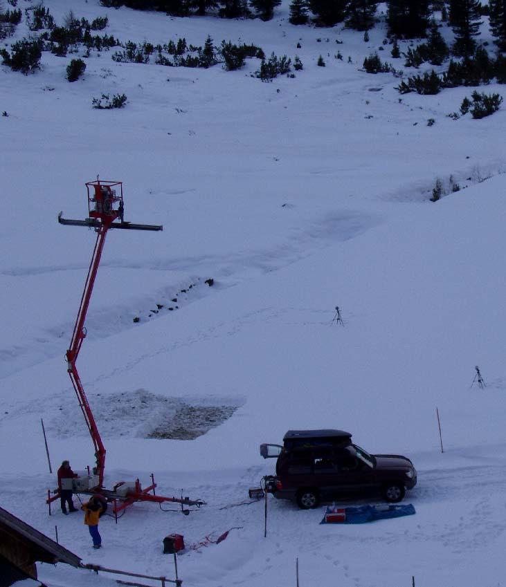

6 Groundbased InSAR Experiment X VV


7 Decorrelation due to Dry Snow Accumulation Dry snow layer deposited on a rough surface. Roughness at sub pixel scale is important σ z represents standard deviation of phase delay within pixel due to snow fall, for distributed scatterer Model calculation of temporal decorrelation due to snow in dependence on the surface roughness
8 Procedure for SWE retrieval


 Brenner")
 Meran (323m)")
9 Snowfree Coherence and Interferogram 19 Jun Sep 2007: Δt=92 days B per = 390 m, H a = 168 m Telfs (633m) Innsbruck (574m) Brenner Pass (1371m) Hochfeiler (3371m) Meran (323m) Brixen (565m)


10 ALOS PALSAR Images Full Pol. Mode LOS Telfs Telfs Innsbruck Telfs Kühtai Kühtai Umhausen Pitztaler Gletscher Obergurgl

11 PALSAR Full Polarimetric Images 2006/07 PALSAR data Interferometric Pairs 30 Sep Nov 2006 B per = 74 m 15 Nov Dec 2006 B per = 2308 m 31 Dec Feb 2007 B per = 594 m


12 ALOS Palsar Coherence 46 Day Period 30 Sep Nov 2006 Bper 74 m Telfs 633 m 15 Nov Dec 2006 Bper 2308 m 31 Dec Feb 2007 Bper 594 m Umhausen 1030 m Kühtai 2040m Pitztaler Gletscher 3340 m Obergurgl 1913 m Thomas LOS Nagler

13 ALOS Palsar Interferograms 46 Day Period 30 Sep Nov 2006 Bper 74 m Telfs 633 m 15 Nov Dec 2006 Bper 2308 m 31 Dec Feb 2007 Bper 594 m Umhausen 1030 m Kühtai 2040m Pitztaler Gletscher 3340 m Obergurgl 1913 m π +π LOS


14 Topo flattened Interferograms 30 Sep Nov 2006 Bper 74 m L-Band HH 31 Dec Feb 2007 Bper 594 m 0/0 cm 0/0 cm 0rad Innsbruck 560m 0rad Snow Height Date1/2 0/2 cm 34/79 cm 0.2 rad 4.4 rad 0/0 cm 5/8 cm 0.3 rad Umhausen 1030 m 0 rad Kühtai 2040m Derived Δφ Pitztaler Gletscher 3340 m 20 cm 2 rad 0/5 cm 70/120 cm 4.6 rad 0.5 rad Fringe Workshop Rhodes, 6/11/ Nov 2007, ESRIN LOS 2π Obergurgl 1913 m 25/45 cm 2 rad

15 Amplitude Image PALSAR Fine Beam Mode Multitemporal average amplitude Image 4/11/2007 and 20/12/2007 Starnberger See Murnau Walchensee Elevation Contour Lines 250 m GAP Telfs Innsbruck
 Phase Image (flatearth corr) Starnberger")
 GAP(698m) Zugspitz (2962m) LOS Zugspitz (2962m) Innsbruck (576 m) LOS")
16 ALOS PALSAR 4 Nov Dec Coherence Image HPeissenberg(988m) Phase Image (flatearth corr) Starnberger See (584m) Starnberger See (584m) HPeissenberg(988m) Walchsee(802m) Walchsee(802m) GAP(698m) GAP(698m) Zugspitz (2962m) LOS Zugspitz (2962m) Innsbruck (576 m) LOS Innsbruck (576 m) π Δt=46 days Bper = 11 m Ha = 5960 m +π
17 Atmospheric Phase Shift: 4 Nov. 20 Dec Radio sounding Station Munich Look Angle : 40 deg Elevation Layer : m Atm. phase shift : rad (0.7 mm SWE => 0.3 cm snow 0.2 g/cm³ snow density) 04/11/07 24h 20/12/07 24h
 Normalized Difference")
 GAP(698m) PALSAR Scene Innsbruck")
18 Modis Snow Cover Information 20 Dec Dec 2007 Bnd ( nm) Normalized Difference Snow Index Snow free Starnberger See (584m) HPeissenberg(988m) GAP(698m) PALSAR Scene Innsbruck (576 m) PALSAR Scene


19 Map of Snow Height Starnberger See (584m) Assumtion: SH = SWE * ρ s Constant Snow Density ρ s =0.20 g/cm³ Hohenpeissenberg 19 cm measured cm retrieved Garmisch Parten Kirchen 5 cm measured < 8 cm retrieved [m] Innsbruck / Innvalley: snowfree
20 Conclusions A procedure for mapping changes of SWE using spaceborne SAR Interferometry has been developed and tested. It requires repeat pass SAR data and snow information at reference stations as input. A limited ALOS PALSAR data set (Full Pol., FBS) of the Austrian Alps has been analysed in order to test the algorithm. Due to the long repeat interval of 46 days the L Band signal decorrelates over most snow covered areas. Coherence suitable for InSAR processing can only be observed in areas with shallow snow. Test samples of SWE maps over such areas were produced. The InSAR based SWE / snow height retrieval provides reasonable results, as locally validated with a small data set of in situ snow observations at automatic meteo stations and coarse resolution snow maps from MODIS. Though L band SAR is less sensitive to temporal decorrelation than higher radar frequencies, shorter repeat intervals are needed for comprehensive exploitation of the InSAR technique for SWE mapping.
SNOW MASS RETRIEVAL BY MEANS OF SAR INTERFEROMETRY
 SNOW MASS RETRIEVAL BY MEANS OF SAR INTERFEROMETRY Helmut Rott (1), Thomas Nagler (1), Rolf Scheiber (2) (1) ENVEO, Environmental Earth Observation OEG, Exlgasse 39, A-6020 Innsbruck, Austria E-mail: Helmut.Rott@enveo.at
CHARACTERISTICS OF SNOW AND ICE MORPHOLOGICAL FEATURES DERIVED FROM MULTI-POLARIZATION TERRASAR-X DATA
 CHARACTERISTICS OF SNOW AND ICE MORPHOLOGICAL FEATURES DERIVED FROM MULTI-POLARIZATION TERRASAR-X DATA Dana Floricioiu 1, Helmut Rott 2, Thomas Nagler 2, Markus Heidinger 2 and Michael Eineder 1 1 DLR,
PROGRESS IN ADDRESSING SCIENCE GOALS FOR SNOW MONITORING BY MEANS OF SAR
 Polar Space Task Group PROGRESS IN ADDRESSING SCIENCE GOALS FOR SNOW MONITORING BY MEANS OF SAR Thomas Nagler, Helmut Rott, ENVEO IT GmbH, Innsbruck, Austria SNOW: Observational Requirements and SAR Products
TEMPORAL VARIABILITY OF ICE FLOW ON HOFSJÖKULL, ICELAND, OBSERVED BY ERS SAR INTERFEROMETRY
 TEMPORAL VARIABILITY OF ICE FLOW ON HOFSJÖKULL, ICELAND, OBSERVED BY ERS SAR INTERFEROMETRY Florian Müller (1), Helmut Rott (2) (1) ENVEO IT, Environmental Earth Observation GmbH, Technikerstrasse 21a,
Snow Water Equivalent (SWE) of dry snow derived from InSAR -theory and results from ERS Tandem SAR data
 of dry snow derived from InSAR -theory and results from ERS Tandem SAR data") Snow Water Equivalent (SWE) of dry snow derived from InSAR -theory and results from ERS Tandem SAR data Tore Guneriussen, Kjell Arild Høgda, Harald Johnsen and Inge Lauknes NORUT IT Ltd., Tromsø Science
Snow Water Equivalent (SWE) of dry snow derived from InSAR -theory and results from ERS Tandem SAR data Tore Guneriussen, Kjell Arild Høgda, Harald Johnsen and Inge Lauknes NORUT IT Ltd., Tromsø Science
ALOS PI Symposium 2009, 9-13 Nov 2009 Hawaii MOTION MONITORING FOR ETNA USING ALOS PALSAR TIME SERIES
 ALOS PI Symposium 2009, 9-13 Nov 2009 Hawaii ALOS Data Nodes: ALOS RA-094 and RA-175 (JAXA) MOTION MONITORING FOR ETNA USING ALOS PALSAR TIME SERIES Urs Wegmüller, Charles Werner and Maurizio Santoro Gamma
CHAPTER-7 INTERFEROMETRIC ANALYSIS OF SPACEBORNE ENVISAT-ASAR DATA FOR VEGETATION CLASSIFICATION
 147 CHAPTER-7 INTERFEROMETRIC ANALYSIS OF SPACEBORNE ENVISAT-ASAR DATA FOR VEGETATION CLASSIFICATION 7.1 INTRODUCTION: Interferometric synthetic aperture radar (InSAR) is a rapidly evolving SAR remote
SNOW COVER MONITORING IN ALPINE REGIONS WITH COSMO-SKYMED IMAGES BY USING A MULTITEMPORAL APPROACH AND DEPOLARIZATION RATIO
 SNOW COVER MONITORING IN ALPINE REGIONS WITH COSMO-SKYMED IMAGES BY USING A MULTITEMPORAL APPROACH AND DEPOLARIZATION RATIO B. Ventura 1, T. Schellenberger 1, C. Notarnicola 1, M. Zebisch 1, T. Nagler
Application of Sentinel-1 SAR for monitoring surface velocity of Greenland outlet glaciers
 pplication of Sentinel-1 SR for monitoring surface velocity of Greenland outlet glaciers Thomas Nagler, Markus Hetzenecker, Helmut Rott and Jan Wuite ENVEO IT GmbH Fringe 2015 OUTLINE Ice Surface Velocity
Snow property extraction based on polarimetry and differential SAR interferometry
 Snow property extraction based on polarimetry and differential SAR interferometry S. Leinß, I. Hajnsek Earth Observation and Remote Sensing, Institute of Enviromental Science, ETH Zürich TerraSAR X and
Noise covariance model for time-series InSAR analysis. Piyush Agram, Mark Simons
 Noise covariance model for time-series InSAR analysis Piyush Agram, Mark Simons Motivation Noise covariance in individual interferograms has been well studied. (Hanssen, 2001) Extend the noise model to
ERS-ENVISAT CROSS-INTERFEROMETRY SIGNATURES OVER DESERTS. Urs Wegmüller, Maurizio Santoro and Christian Mätzler
 ERS-ENVISAT CROSS-INTERFEROMETRY SIGNATURES OVER DESERTS Urs Wegmüller, Maurizio Santoro and Christian Mätzler Gamma Remote Sensing AG, Worbstrasse 225, CH-3073 Gümligen, Switzerland, http://www.gamma-rs.ch,
RADAR Remote Sensing Application Examples
 RADAR Remote Sensing Application Examples! All-weather capability: Microwave penetrates clouds! Construction of short-interval time series through cloud cover - crop-growth cycle! Roughness - Land cover,
EUROPEAN SPACE AGENCY STUDY CONTRACT REPORT UNDER ESA CONTRACT NO 16366/02/NL/MM
 THE USE OF SYNTHETIC APERTURE RADAR (SAR) INTERFEROMETRY TO RETRIEVE BIO- AND GEO-PHYSICAL VARIABLES FINAL REPORT EXECUTIVE SUMMARY EUROPEAN SPACE AGENCY STUDY CONTRACT REPORT UNDER ESA CONTRACT NO PREPARED
PHASE UNWRAPPING. Sept. 3, 2007 Lecture D1Lb4 Interferometry: Phase unwrapping Rocca
 PHASE UNWRAPPING 1 Phase unwrapping 2 1D Phase unwrapping Problem: given the wrapped phase ψ=w(φ) find the unwrapped one ψ. The wrapping operator: W(φ)=angle(exp(j φ)), gives always solution -π π and is
ADVANCEMENTS IN SNOW MONITORING
 Polar Space Task Group ADVANCEMENTS IN SNOW MONITORING Thomas Nagler, ENVEO IT GmbH, Innsbruck, Austria Outline Towards a pan-european Multi-sensor Snow Product SnowPEx Summary Upcoming activities SEOM
Snow Cover Applications: Major Gaps in Current EO Measurement Capabilities
 Snow Cover Applications: Major Gaps in Current EO Measurement Capabilities Thomas NAGLER ENVEO Environmental Earth Observation IT GmbH INNSBRUCK, AUSTRIA Polar and Snow Cover Applications User Requirements
IEEE GEOSCIENCE AND REMOTE SENSING LETTERS, VOL. 1, NO. 2, APRIL
 IEEE GEOSCIENCE AND REMOTE SENSING LETTERS, VOL. 1, NO. 2, APRIL 2004 57 Delta-K Interferometric SAR Technique for Snow Water Equivalent (SWE) Retrieval Geir Engen, Tore Guneriussen, and Øyvind Overrein
Analysis of the Temporal Behavior of Coherent Scatterers (CSs) in ALOS PalSAR Data
 in ALOS PalSAR Data") Analysis of the Temporal Behavior of Coherent Scatterers (CSs) in ALOS PalSAR Data L. Marotti, R. Zandona-Schneider & K.P. Papathanassiou German Aerospace Center (DLR) Microwaves and Radar Institute0 PO.BOX
Analysis of the Temporal Behavior of Coherent Scatterers (CSs) in ALOS PalSAR Data L. Marotti, R. Zandona-Schneider & K.P. Papathanassiou German Aerospace Center (DLR) Microwaves and Radar Institute0 PO.BOX
The Potential of High Resolution Satellite Interferometry for Monitoring Enhanced Oil Recovery
 The Potential of High Resolution Satellite Interferometry for Monitoring Enhanced Oil Recovery Urs Wegmüller a Lutz Petrat b Karsten Zimmermann c Issa al Quseimi d 1 Introduction Over the last years land
Wave Propagation Model for Coherent Scattering from a Randomly Distributed Target
 Wave Propagation Model for Coherent Scattering from a Randomly Distributed Target Don Atwood,Ben Matthiss, Liza Jenkins, Shimon Wdowinski, Sang Hoon Hong, and Batuhan Osmanoglu Outline Requirements for
Model based forest height estimation with ALOS/PalSAR: A first study.
 Model based forest height estimation with ALOS/PalSAR: A first study. K.P. Papathanassiou*, I. Hajnsek*, T.Mette*, S.R. Cloude** and A. Moreira* * (DLR) (DLR-HR) Oberpfaffenhofen, Germany ** AEL Consultants
GLOBAL FOREST CLASSIFICATION FROM TANDEM-X INTERFEROMETRIC DATA: POTENTIALS AND FIRST RESULTS
 GLOBAL FOREST CLASSIFICATION FROM TANDEM-X INTERFEROMETRIC DATA: POTENTIALS AND FIRST RESULTS Michele Martone, Paola Rizzoli, Benjamin Bräutigam, Gerhard Krieger Microwaves and Radar Institute German Aerospace
Atmospheric Phase Screen (APS) estimation and modeling for radar interferometry
 estimation and modeling for radar interferometry") Atmospheric Phase Screen (APS) estimation and modeling for radar interferometry Ramon Hanssen¹, Alessandro Ferretti², Marco Bianchi², Rossen Grebenitcharsky¹, Frank Kleijer¹, Ayman Elawar¹ ¹ Delft University
Atmospheric Phase Screen (APS) estimation and modeling for radar interferometry Ramon Hanssen¹, Alessandro Ferretti², Marco Bianchi², Rossen Grebenitcharsky¹, Frank Kleijer¹, Ayman Elawar¹ ¹ Delft University
SAR Remote Sensing of Snow Parameters in Norwegian Areas Current Status and Future Perspective
 182 Progress In Electromagnetics Research Symposium 2006, Cambridge, USA, March 26-29 SAR Remote Sensing of Snow Parameters in Norwegian Areas Current Status and Future Perspective R. Storvold, E. Malnes,
Detecting an area affected by forest fires using ALOS PALSAR
 Detecting an area affected by forest fires using ALOS PALSAR Keiko Ishii (1), Masanobu Shimada (2), Osamu Isoguchi (2), Kazuo Isono (1) (1)Remote Sensing Technology Center of Japan (2)Japan Aerospace Exploration
DIFFERENTIAL INSAR STUDIES IN THE BOREAL FOREST ZONE IN FINLAND
 DIFFERENTIAL INSAR STUDIES IN THE BOREAL FOREST ZONE IN FINLAND Kirsi Karila (1,2), Mika Karjalainen (1), Juha Hyyppä (1) (1) Finnish Geodetic Institute, P.O. Box 15, FIN-02431 Masala, Finland, Email:
In order to obtain a long term monitoring result for the Kilauea Volcano, ALOS PALSAR images taken on Track 287, Frame 38, ascending orbit with 21.5 d
 ALOS PALSAR OBSERVATION OF KILAUEA VOLCANO ACTIVITIES FROM 2006 TO 2009 Zhe Hu, Linlin Ge, Xiaojing Li, Kui Zhang, Alex Hay-Man NG and Chris Rizos Cooperative Research Centre for Spatial Information &
Evaluation of sub-kilometric numerical simulations of C-band radar backscatter over the french Alps against Sentinel-1 observations
 Evaluation of sub-kilometric numerical simulations of C-band radar backscatter over the french Alps against Sentinel-1 observations Gaëlle Veyssière, Fatima Karbou, Samuel Morin, Matthieu Lafaysse Monterey,
Burst overlapping of ALOS-2 PALSAR-2 ScanSAR-ScanSAR interferometry
 Burst overlapping of ALOS-2 PALSAR-2 ScanSAR-ScanSAR interferometry Japan Aerospace Exploration Agency Earth Observation Research Center Ryo Natsuaki, Takeshi Motohka, Shinichi Suzuki and Masanobu Shimada
Retrieving 3D deformation pattern of a landslide with hiresolution InSAR and in-situ measurements: Just landslide case-study
 Retrieving 3D deformation pattern of a landslide with hiresolution InSAR and in-situ measurements: Just landslide case-study Zbigniew Perski (1), Petar Marinković (2), Yngvar Larsen (3), Tomasz Wojciechowski
Current and near-future SAR (and LIDAR) systems
 systems") Current and near-future SAR (and LIDAR) systems Ake Rosenqvist solo Earth Observation, Japan Mexico City, Mexico June 7-9, 2016 1 Current and near-future SARs & LIDARs ALOS-2/PALSAR-2 global mosaics SAOCOM-1A/1B
Current and near-future SAR (and LIDAR) systems Ake Rosenqvist solo Earth Observation, Japan Mexico City, Mexico June 7-9, 2016 1 Current and near-future SARs & LIDARs ALOS-2/PALSAR-2 global mosaics SAOCOM-1A/1B
AlOS-PALSAR data for Landslide Monitoring and Geological Mapping
 AlOS-PALSAR data for Landslide Monitoring and Geological Mapping Vern Singhroy, P-J Alasset, G Pavlic Canada Centre for Remote Sensing Ottawa, Canada vern.singhroy@ccrs.nrcan.gc.ca Objectives InSAR monitoring
IEEE GEOSCIENCE AND REMOTE SENSING LETTERS, VOL. 11, NO. 8, AUGUST
 IEEE GEOSCIENCE AND REMOTE SENSING LETTERS, VOL. 11, NO. 8, AUGUST 2014 1355 Multitemporal Multitrack Monitoring of Wetland Water Levels in the Florida Everglades Using ALOS PALSAR Data With Interferometric
Radar Remote Sensing: Monitoring Ground Deformations and Geohazards from Space
 Radar Remote Sensing: Monitoring Ground Deformations and Geohazards from Space Xiaoli Ding Department of Land Surveying and Geo-Informatics The Hong Kong Polytechnic University A Question 100 km 100 km
Measuring rock glacier surface deformation using SAR interferometry
 Permafrost, Phillips, Springman & Arenson (eds) 2003 Swets & Zeitlinger, Lisse, ISBN 90 5809 582 7 Measuring rock glacier surface deformation using SAR interferometry L.W. Kenyi Institute for Digital Image
DLR s TerraSAR-X contributes to international fleet of radar satellites to map the Arctic and Antarctica
 DLR s TerraSAR-X contributes to international fleet of radar satellites to map the Arctic and Antarctica The polar regions play an important role in the Earth system. The snow and ice covered ocean and
MULTI-POLARISATION MEASUREMENTS OF SNOW SIGNATURES WITH AIR- AND SATELLITEBORNE SAR
 EARSeL eproceedings 5, 1/2006 111 MULTI-POLARISATION MEASUREMENTS OF SNOW SIGNATURES WITH AIR- AND SATELLITEBORNE SAR Eirik Malnes 1, Rune Storvold 1, Inge Lauknes 1 and Simone Pettinato 2 1. Norut IT,
GEOGG141 Principles & Practice of Remote Sensing (PPRS) RADAR III: Applications Revision
 RADAR III: Applications Revision") UCL DEPARTMENT OF GEOGRAPHY GEOGG141 Principles & Practice of Remote Sensing (PPRS) RADAR III: Applications Revision Dr. Mathias (Mat) Disney UCL Geography Office: 113, Pearson Building Tel: 7670 0592
UCL DEPARTMENT OF GEOGRAPHY GEOGG141 Principles & Practice of Remote Sensing (PPRS) RADAR III: Applications Revision Dr. Mathias (Mat) Disney UCL Geography Office: 113, Pearson Building Tel: 7670 0592
Modeling Surface and Subsurface Scattering from Saline Soils
 Modeling Surface and Subsurface Scattering from Saline Soils PolInSAR 2007 Tony Freeman, Jet Propulsion Laboratory Tom Farr, Jet Propulsion Laboratory Philippe Paillou, Astronomical Observatory of Bordeaux
SURFACE DEFORMATION OF ALPINE TERRAIN DERIVED BY PS-INSAR TECHNIQUE ON THE SIACHEN GLACIER
 SURFACE DEFORMATION OF ALPINE TERRAIN DERIVED BY PS-INSAR TECHNIQUE ON THE SIACHEN GLACIER Junchao Shi and Ling Chang Department of Remote Sensing, Delft University of Technology, the Netherlands. ABSTRACT
Global SWE Mapping by Combining Passive and Active Microwave Data: The GlobSnow Approach and CoReH 2 O
 Global SWE Mapping by Combining Passive and Active Microwave Data: The GlobSnow Approach and CoReH 2 O April 28, 2010 J. Pulliainen, J. Lemmetyinen, A. Kontu, M. Takala, K. Luojus, K. Rautiainen, A.N.
COAL MINE LAND SUBSIDENCE MONITORING BY USING SPACEBORNE INSAR DATA-A CASE STUDY IN FENGFENG, HEBEI PROVINCE, CHINA
 COAL MINE LAND SUBSIDENCE MONITORING BY USING SPACEBORNE INSAR DATA-A CASE STUDY IN FENGFENG, HEBEI PROVINCE, CHINA Li Cao a, Yuehua Zhang a, Jianguo He a, Guang Liu b,huanyin Yue b, Runfeng Wang a, Linlin
Fulong Chen Nicola Masini, Jie Liu, Jiangbin You, Rosa Lasaponara MAEIC
 Archaeological prospection in the Western Regions of Western Han Dynasty by satellite synthetic aperture radar data, case studies of Yumen Frontier Pass and Niya ruins Fulong Chen chenfl@radi.ac.cn Nicola
Characterization of Snow Facies on the Greenland Ice Sheet Observed by TanDEM-X Interferometric SAR Data
 Article Characterization of Snow Facies on the Greenland Ice Sheet Observed by TanDEM-X Interferometric SAR Data Paola Rizzoli 1, *, Michele Martone 1, Helmut Rott 2,3 and Alberto Moreira 1 1 German Aerospace
Advancing Remote-Sensing Methods for Monitoring Geophysical Parameters
 Advancing Remote-Sensing Methods for Monitoring Geophysical Parameters Christian Mätzler (Retired from University of Bern) Now consultant for Gamma Remote Sensing, Switzerland matzler@iap.unibe.ch TERENO
InSAR techniques and applications for monitoring landslides and subsidence
 Geoinformation for European-wide Integration, Benes (ed.) 2003 Millpress, Rotterdam, ISBN 90-77017-71-2 InSAR techniques and applications for monitoring landslides and subsidence H. Rott & T. Nagler Institut
Available online at GHGT-9. Detection of surface deformation related with CO 2 injection by DInSAR at In Salah, Algeria
 Available online at www.sciencedirect.com Energy Procedia 100 (2009) (2008) 2177 2184 000 000 Energy Procedia www.elsevier.com/locate/procedia www.elsevier.com/locate/xxx GHGT-9 Detection of surface deformation
Glaciers Response after Disintegration of Northern Larsen Ice Shelf, Antarctic Peninsula, observed by Multisensor Satellite Data
 Glaciers Response after Disintegration of Northern Larsen Ice Shelf, Antarctic Peninsula, observed by Multisensor Satellite Data Helmut Rott1,2, Jan Wuite1, Thomas Nagler1, Dana Floricioiu3, Michael Kern4
Multi-temporal archaeological and environmental prospection in Nasca (Peru) with ERS-1/2, ENVISAT and Sentinel-1A C-band SAR data
 with ERS-1/2, ENVISAT and Sentinel-1A C-band SAR data") 12-13 November 215 ESA-ESRIN, Frascati (Rome), Italy Day 1 Session: Historical Landscapes and Environmental Analysis Multi-temporal archaeological and environmental prospection in Nasca (Peru) with ERS-1/2,
12-13 November 215 ESA-ESRIN, Frascati (Rome), Italy Day 1 Session: Historical Landscapes and Environmental Analysis Multi-temporal archaeological and environmental prospection in Nasca (Peru) with ERS-1/2,
6QRZPHOWPRGHOOLQJXVLQJ5DGDUVDWGDWD
 3UHSULQWRI3URFRI$'52)LQDO6\PSRVLXP2FW0RQWUHDO&DQDGD 6QRZPHOWPRGHOOLQJXVLQJ5DGDUVDWGDWD 7KRPDV1DJOHU+HOPXW5RWW*UDKDP*OHQGLQQLQJ,QVWLWXWI U0HWHRURORJLHXQG*HRSK\VLN8QLYHUVLWlW,QQVEUXFN,QQUDLQ$,QQVEUXFN$XVWULD
Modeling of Atmospheric Effects on InSAR Measurements With the Method of Stochastic Simulation
 Modeling of Atmospheric Effects on InSAR Measurements With the Method of Stochastic Simulation Z. W. LI, X. L. DING Department of Land Surveying and Geo-Informatics, Hong Kong Polytechnic University, Hung
Implementation of Multi-Temporal InSAR to monitor pumping induced land subsidence in Pingtung Plain, Taiwan
 Implementation of Multi-Temporal InSAR to monitor pumping induced land subsidence in Pingtung Plain, Taiwan Presenter: Oswald Advisor: Chuen-Fa Ni Date: March 09, 2017 Literature Review Pingtung Plain
PSI Precision, accuracy and validation aspects
 PSI Precision, accuracy and validation aspects Urs Wegmüller Gamma Remote Sensing AG, Gümligen, Switzerland, wegmuller@gamma-rs.ch Contents - Precision - Accuracy - Systematic errors - Atmospheric effects
Soil moisture retrieval over periodic surfaces using PolSAR data
 Soil moisture retrieval over periodic surfaces using PolSAR data Sandrine DANIEL Sophie ALLAIN Laurent FERRO-FAMIL Eric POTTIER IETR Laboratory, UMR CNRS 6164, University of Rennes1, France Contents Soil
Interferometric SAR analysis for Characterizing Surface Changes of an Active Volcano using Open Source Software
 Interferometric SAR analysis for Characterizing Surface Changes of an Active Volcano using Open Source Software Asep SAEPULOH1, Katsuaki KOIKE1, Makoto OMURA2 1 Department of Life and Environmental Sciences,
III. Publication III. c 2004 Authors
 III Publication III J-P. Kärnä, J. Pulliainen, K. Luojus, N. Patrikainen, M. Hallikainen, S. Metsämäki, and M. Huttunen. 2004. Mapping of snow covered area using combined SAR and optical data. In: Proceedings
SAR Coordination for Snow Products
 Polar SAR Coordination Working Meeting 5 SAR Coordination for Snow Products David Small 1, Thomas Nagler 2, David Jäger 1, Christoph Rohner 1, Adrian Schubert 1 1: University of Zurich, Switzerland 2:
K&C Phase 4 Status report. Use of short-period ALOS-2 observations for vegetation characterization and classification
 K&C Phase 4 Status report Use of short-period ALOS-2 observations for vegetation characterization and classification Paul Siqueira University of Massachusetts, Amherst Science Team meeting #22 Tokyo, Japan,
Towards the use of SAR observations from Sentinel-1 to study snowpack properties in Alpine regions
 Towards the use of SAR observations from Sentinel-1 to study snowpack properties in Alpine regions Gaëlle Veyssière, Fatima Karbou, Samuel Morin et Vincent Vionnet CNRM-GAME /Centre d Etude de la Neige
MERIS and OSCAR: Online Services for Correcting Atmosphere in Radar
 National Aeronautics and Space Administration MERIS and OSCAR: Online Services for Correcting Atmosphere in Radar Eric Fielding and Evan Fishbein Jet Propulsion Laboratory, California Inst. of Tech. Zhenhong
GEOMORPHOLOGICAL MAPPING WITH RESPECT TO AMPLITUDE, COHERENCEAND PHASE INFORMATION OF ERS SAR TANDEM PAIR
 GEOMORPHOLOGICAL MAPPING WITH RESPECT TO AMPLITUDE, COHERENCEAND PHASE INFORMATION OF ERS SAR TANDEM PAIR AUNG LWIN Assistant Researcher Remote Sensing Department Mandalay Technological University, Myanmar
Quantification and visualization of periglacial surface deformation in the Inneres Hochebenkar cirque, Ötztal Alps, Austria
 Quantification and visualization of periglacial surface deformation in the Inneres Hochebenkar cirque, Ötztal Alps, Austria Institute of Geodesy Graz University of Technology Steyrergasse 30 A-8010 Graz,
Prospects of microwave remote sensing for snow hydrology
 Hydrologie Applications of Space Technology (Proceedings of the Cocoa Beach Workshop, Florida, August 1985). IAHS Publ. no. 160,1986. Prospects of microwave remote sensing for snow hydrology HELMUT ROTT
SAR interferometry Status and future directions. Rüdiger Gens
 SAR interferometry Status and future directions Rüdiger Gens Polarimetric InSAR Polarimetric InSAR InSAR - Status and future directions sensitivity to changes in surface scattering, even in the presence
ScanSAR Interferometry with PALSAR
 ScanSAR Interferometry with PALSAR Authors: David Sandwell, Rob Mellors, and Xiaopeng Tong Funding: NASA EarthScope Program - InSAR and Geodetic Imaging Component Data: ALOS PALSAR - JAXA EORC and ASF
Journal of Geodynamics
 Journal of Geodynamics 49 (2010) 161 170 Contents lists available at ScienceDirect Journal of Geodynamics journal homepage: http://www.elsevier.com/locate/jog Recent advances on surface ground deformation
Linking Different Spatial Scales For Retrieval Of Sea Ice Conditions From SAR Images
 Linking Different Spatial Scales For Retrieval Of Sea Ice Conditions From SAR Images Matt Arkett 2, Wolfgang Dierking 1, Jakob Griebel 1, Thomas Hollands 1, Stefanie Linow 1, Eero Rinne 3, Markku Similä
InSAR measurements of volcanic deformation at Etna forward modelling of atmospheric errors for interferogram correction
 InSAR measurements of volcanic deformation at Etna forward modelling of atmospheric errors for interferogram correction Rachel Holley, Geoff Wadge, Min Zhu Environmental Systems Science Centre, University
On the Exploitation of Target Statistics for SAR Interferometry Applications
 On the Exploitation of Target Statistics for SAR Interferometry Applications A. Monti Guarnieri, S. Tebaldini Politecnico di Milano Abstract This paper focuses on multi-image Synthetic Aperture Radar Interferometry
Retrieving Snowfall Rate with Satellite Passive Microwave Measurements
 Retrieving Snowfall Rate with Satellite Passive Microwave Measurements Huan Meng 1, Ralph Ferraro 1, Banghua Yan 1, Cezar Kongoli 2, Nai-Yu Wang 2, Jun Dong 2, Limin Zhao 1 1 NOAA/NESDIS, USA 2 Earth System
 http://topex.ucsd.edu/gmtsar amplitude and phase coherence and pixel matching resolution: optical vs. microwave D s = 2H sinθ r = 2H λ L H = 800km. Optical : L = 1m λ = 0.5µm D s = 0.8m Microwave : L
SNOW MONITORING USING MICROWAVE RADARS
 Helsinki University of Technology Laboratory of Space Technology Espoo, January 2001 REPORT 44 SNOW MONITORING USING MICROWAVE RADARS Jarkko Koskinen Thesis for the degree of Doctor of Technology Snow
InSAR atmospheric effects over volcanoes - atmospheric modelling and persistent scatterer techniques
 InSAR atmospheric effects over volcanoes - atmospheric modelling and persistent scatterer techniques Rachel Holley 1,2, Geoff Wadge 1, Min Zhu 1, Ian James 3, Peter Clark 4 Changgui Wang 4 1. Environmental
Slow Deformation of Mt. Baekdu Stratovolcano Observed by Satellite Radar Interferometry
 Slow Deformation of Mt. Baekdu Stratovolcano Observed by Satellite Radar Interferometry Sang-Wan Kim and Joong-Sun Won Department of Earth System Sciences, Yonsei University 134 Shinchon-dong, Seodaemun-gu,
A New Approach to Estimate Forest Parameters Using Dual-Baseline POL-InSAR Data
 Jan 26-30, 2009 Frascati, Italy A New Approach to Estimate Forest Parameters Using Dual-Baseline POL-InSAR Data Lu Bai, Wen ong, Fang Cao, Yongsheng Zhou bailu8@gmail.com fcao@mail.ie.ac.cn National Key
Making a case for full-polarimetric radar remote sensing
 Making a case for full-polarimetric radar remote sensing Jeremy Nicoll Alaska Satellite Facility, University of Alaska Fairbanks 1 Polarization States of a Coherent Plane Wave electric field vector vertically
A New Model-Based Scattering Power Decomposition for Polarimetric SAR and Its Application in Analyzing Post-Tsunami Effects
 A New Model-Based Scattering Power Decomposition for Polarimetric SAR and Its Application in Analyzing Post-Tsunami Effects Yi Cui, Yoshio Yamaguchi Niigata University, Japan Background (1/5) POLSAR data
APPLICABILITY OF PSINSAR FOR BUILDING HAZARD IDENTIFICATION
 APPLICABILITY OF PSINSAR FOR BUILDING HAZARD IDENTIFICATION. STUDY OF THE 29 JANUARY 2006 KATOWICE EXHIBITION HALL COLLAPSE AND THE 24 FEBRUARY 2006 MOSCOW BASMANNY MARKET COLLAPSE Zbigniew Perski (1),
ALOS-2 Basic Observation Scenario (First Edition) January 10, 2014 JAXA/ALOS-2 Project
 January 10, 2014 JAXA/ALOS-2 Project") ALOS-2 Basic Observation Scenario (First Edition) January 10, 2014 JAXA/ALOS-2 Project 1 1.First edition 2.Purpose and Background 3.Approach of the Basic Observation Scenario 4.Basic Observation
ALOS-2 Basic Observation Scenario (First Edition) January 10, 2014 JAXA/ALOS-2 Project 1 1.First edition 2.Purpose and Background 3.Approach of the Basic Observation Scenario 4.Basic Observation
General Four-Component Scattering Power Decomposition with Unitary Transformation of Coherency Matrix
 1 General Four-Component Scattering Power Decomposition with Unitary Transformation of Coherency Matrix Gulab Singh, Member, IEEE, Yoshio Yamaguchi, Fellow, IEEE and Sang-Eun Park, Member, IEEE Abstract
THREE DIMENSIONAL DETECTION OF VOLCANIC DEPOSIT ON MOUNT MAYON USING SAR INTERFEROMETRY
 ABSTRACT THREE DIMENSIONAL DETECTION OF VOLCANIC DEPOSIT ON MOUNT MAYON USING SAR INTERFEROMETRY Francis X.J. Canisius, Kiyoshi Honda, Mitsuharu Tokunaga and Shunji Murai Space Technology Application and
ERS-ENVISAT Cross-interferometry for Coastal DEM Construction
 ERS-ENVISAT Cross-interferometry for Coastal DEM Construction Sang-Hoon Hong and Joong-Sun Won Department of Earth System Sciences, Yonsei University, 134 Shinchon-dong, Seodaemun-gu, 120-749, Seoul, Korea
Analysis of mining deformations based on PSInSAR technique case study of the Walbrzych coal mines (Poland)
") Analysis of mining deformations based on PSInSAR technique case study of the Walbrzych coal mines (Poland) Dr. Jan Blachowski, Dr. Wojciech Milczarek Faculty of Geoengineering, Mining and Geology, Wroclaw
Analysis of mining deformations based on PSInSAR technique case study of the Walbrzych coal mines (Poland) Dr. Jan Blachowski, Dr. Wojciech Milczarek Faculty of Geoengineering, Mining and Geology, Wroclaw
Technical Documentation and Program Listings for MEMLS 99.1, Microwave Emission Model of Layered Snowpacks
 Technical Documentation and Program Listings for MEMLS 99., Microwave Emission Model of Layered Snowpacks Andreas Wiesmann, Christian Mätzler Abstract A thermal microwave emission model of layered snowpacks
Observation of Surface Displacements on Glaciers, Sea Ice, and Ice Shelves Around Canisteo Peninsula, West Antarctica Using 4-Pass DInSAR
 4 hyangsun@kangwon.ac.kr, hoonyol@kangwon.ac.kr Observation of Surface Displacements on Glaciers, Sea Ice, and Ice Shelves Around Canisteo Peninsula, West Antarctica Using 4-Pass DInSAR Hyangsun Han and
DETECTING ICE MOTION IN GROVE MOUNTAINS, EAST ANTARCTICA WITH ALOS/PALSAR AND ENVISAT/ASAR DATA
 DETECTING ICE MOTION IN GROVE MOUNTAINS, EAST ANTARCTICA WITH ALOS/PALSAR AND ENVISAT/ASAR DATA TIAN Xin (1), LIAO Mingsheng (1), ZHOU Chunxia (2), ZHOU Yu (3) (1) State Key Laboratory of Information Engineering
Landslide Characteristics and Observations
 Landslide Characteristics and Observations Lecture at the Summer School Alpbach 2006 by Helmut Rott Dept. of Meteorology & Geophysics, Univ. of Innsbruck & ENVEO IT GmbH, Innsbruck AUSTRIA Contents of
InSAR water vapour correction models: GPS, MODIS, MERIS and InSAR integration
 InSAR water vapour correction models: GPS, MODIS, MERIS and InSAR integration Zhenhong Li (1), Eric J. Fielding (2), Paul Cross (1), and Jan-Peter Muller (1) (1): Department of Geomatic Engineering, University
K&C Phase 4 Status report. Use of short-period ALOS-2 observations for vegetation characterization and classification
 K&C Phase 4 Status report Use of short-period ALOS-2 observations for vegetation characterization and classification Paul Siqueira, Tracy Whelen University of Massachusetts, Amherst Yang Lei NASA JPL Science
Haiti Earthquake (12-Jan-2010) co-seismic motion using ALOS PALSAR
 co-seismic motion using ALOS PALSAR") Haiti Earthquake (12-Jan-2010) co-seismic motion using ALOS PALSAR Urs Wegmüller, Charles Werner, Maurizio Santoro Gamma Remote Sensing, CH-3073 Gümligen, Switzerland SAR data: JAXA, METI; PALSAR AO Project
Haiti Earthquake (12-Jan-2010) co-seismic motion using ALOS PALSAR Urs Wegmüller, Charles Werner, Maurizio Santoro Gamma Remote Sensing, CH-3073 Gümligen, Switzerland SAR data: JAXA, METI; PALSAR AO Project
ALPSAR , A FIELD EXPERIMENT ON SNOW OBSERVATIONS AND PARAMETER RETRIEVALS WITH KU- AND X-BAND RADAR
 ALPSAR 2012-13, A FIELD EXPERIMENT ON SNOW OBSERVATIONS AND PARAMETER RETRIEVALS WITH KU- AND X-BAND RADAR Helmut Rott (1), Thomas Nagler (1), RainerPrinz (1), Karl Voglmeier (1), Reinhard Fromm (2), Marc
Deformation measurement using SAR interferometry: quantitative aspects
 Deformation measurement using SAR interferometry: quantitative aspects Michele Crosetto (1), Erlinda Biescas (1), Ismael Fernández (1), Ivan Torrobella (1), Bruno Crippa (2) (1) (2) Institute of Geomatics,
Methods and performances for multi-pass SAR Interferometry
 Methods and performances for multi-pass SAR Interferometry Methods and performances for multi-pass SAR Interferometry Stefano Tebaldini and Andrea Monti Guarnieri Dipartimento di Elettronica e Informazione
Application of differential SAR interferometry for studying eruptive event of 22 July 1998 at Mt. Etna. Abstract
 Application of differential SAR interferometry for studying eruptive event of 22 July 1998 at Mt. Etna Coltelli M. 1, Puglisi G. 1, Guglielmino F. 1, Palano M. 2 1 Istituto Nazionale di Geofisica e Vulcanologia,
Atmospheric Water Vapor Effect on GNSS Signals and InSAR Data
 Atmospheric Water Vapor Effect on GNSS Signals and InSAR Data Basic Concept and Preliminary Results F. Alshawaf 1, S. Hinz 1, A. Thiele 1 T. Fuhrmann 2, B. Heck 2, A. Knöpfler 2, X. Luo 2, M. Mayer 2,
Spatiotemporal variations of alpine climate, snow cover and phenology
 Spatiotemporal variations of alpine climate, snow cover and phenology S. Asam, M. Callegari, M. Matiu, G. Fiore, L. De Gregorio, A. Jacob, A. Menzel, C. Notarnicola, M. Zebisch Asam et al., Spatiotemporal
MAPPING DEFORMATION OF MAN-MADE LINEAR FEATURES USING DINSAR TECHNIQUE
 MAPPING DEFORMATION OF MAN-MADE LINEAR FEATURES USING DINSAR TECHNIQUE H. Wu a, *, Y. Zhang a, J. Zhang a, X. Chen b a Key Laboratory of Mapping from Space of State Bureau of Surveying and Mapping, Chinese
Improved PSI Performance for Landslide Monitoring Applications. J. Duro, R. Iglesias, P. Blanco-Sánchez, F. Sánchez and D. Albiol
 Improved PSI Performance for Landslide Monitoring Applications J. Duro, R. Iglesias, P. Blanco-Sánchez, F. Sánchez and D. Albiol Outline Area of Study Previous PSI (and others) studies Main conclusions
Remote Sensing of Snow GEOG 454 / 654
 Remote Sensing of Snow GEOG 454 / 654 What crysopheric questions can RS help to answer? 2 o Where is snow lying? (Snow-covered area or extent) o How much is there? o How rapidly is it melting? (Area, depth,