PHASE UNWRAPPING. Sept. 3, 2007 Lecture D1Lb4 Interferometry: Phase unwrapping Rocca
|
|
|
- Sharon McLaughlin
- 6 years ago
- Views:
Transcription
1 PHASE UNWRAPPING 1
2 Phase unwrapping 2
3 1D Phase unwrapping Problem: given the wrapped phase ψ=w(φ) find the unwrapped one ψ. The wrapping operator: W(φ)=angle(exp(j φ)), gives always solution -π π and is ~ to the remainder (modulus 2 π) The problem is ill-conditioned due to sampled nature (how many 2π from sample to sample? Solution is not unique. We need some regularization criteria to find one. We assume that the phase difference between 2 samples (adjacent) is not aliased, hence the discrete gradient Δφ = φ i - φ i-1 should always be < π. We estimate it by wrapping the difference of the wrapped phase Δ e φ= W(Δ ψ). For example ψ i-1 = 3π/4; ψ i =- 3π/4 Δ ψ= -6/4 π we correct it into W(Δ ψ)= -6/4π+2π =π/2 W(Δ ψ) ψ i-1 =3π/4 ψ i =-3π/4 After correcting the wrong gradient (assuming that Δφ should be < π) we can integrate the gradient to get the estimate of φ (but for a constant). The technique is highly non linear due to the wrapping operator. 3
4 4


5 The technique shown is successful provided that the true gradient is bounded to < π. It is unlikely so when both the sampled topography is rough and elevations are > ΔHamb. Slow varying topographies are not a problem even if elevations are large. Rough topographies are not a problem if elevations are contained (see multi-baseline pu). 5

6 2D PU artifacts 6
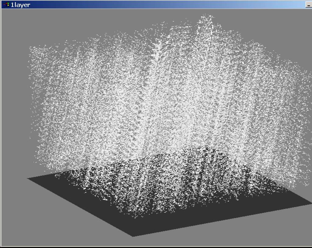
7 1D Phase unwrapping: not successful For large elevation and large baseline the problem breaks down fast and probability of success (number of singular points) drops. 7
8 2D Phase unwrapping In the 2D we have different possible integration paths and we want to ensure at least the independence of the solution on the path. The unwrapped phase field should be conservative (rotation free): Δφ = 0 where the gradient is now a two component vector Δφ= [Δφ i Δφ k ] T At least, for a close path (a curl), we want to be back at the same height! This does not hold as soon as the curl embrace a vortex (residue), where phase is not defined: r r real( s( P)) = imag( s( P)) = Amplitude should be zero, and this happens only in the presence of noise. In absence of vortex, all fringes are well formed: they are closed (eventually to the image edges) and unwrapping is an easy task: just counting them. In presence of vortex, fringes appears and disappear suddenly and closing them is a hard task. 0 8

9 2D Phase unwrapping B Gradient, φ = ( φ3 φ1) ( φ2 φ1) rg az B n r2 r1 P 1 P 2 P 3 range azimuth range azimuth 9

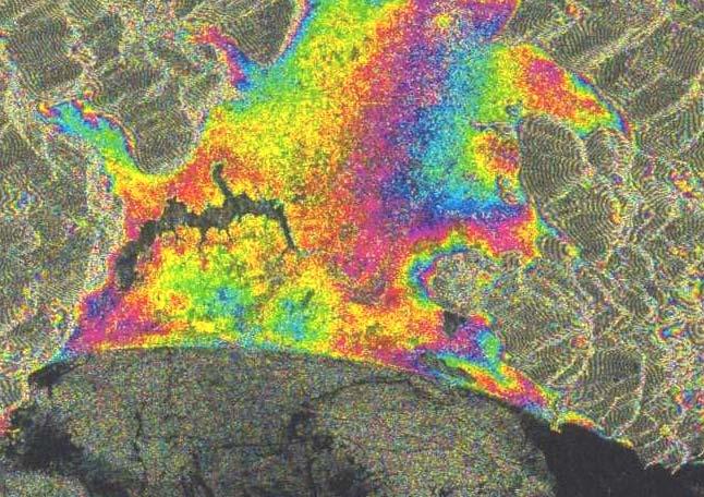
10 Example: constant slope We assume a constant range slope (the most common case). +π re=0 -π +π im=0 -π We assume the phase rotating counter clockwise. Real parts zero for -π/2 or π /2. Image parts zero for 0 or π. In absence of noise real and imaginary parts never crosses. However, the steeper the slope, the closest the lines. 10
11 Example: constant slope + noise Noise shifts re=0 and im=0 lines. A crossing may happen. re=0 im=0 For small noise, crossings are paired and nearby. im=0 re=0 im<0 re>0 im>0 re>0 im<0 re<0 When the summation path contours the vortex, the line integral increases by +2π (or - 2π) every circuitation. In fact every time we cross a blue or an orange line, we change to the adjacent quadrant. In the example, the contour integral adds -2π for every circuitation of the vortex. 11
12 Finding vortices (residuals) Residuals cannot be found by inspection, since data are known on the sampled grid. However, it is enough to compute the shortest line integral, Δφ, on a square of 4 samples around the vortex. Residuals should never be encircled by integration paths, since solution will be non conservative. Residuals are always in couples of opposite sign (yet one of the two can be outside the image). If we connect each couple by a ghost line, never to be crossed, then we avoid adding 2π to the contour integral. Residuals can be due to topography (elevation aliasing) or noise (the sensitivity increases in areas sloping toward the satellite, since the phase contour lines are closer). Low noise creates short dipoles, that can be easily handled. Situation improves with SNR; however, smoothing the phase field is mandatory!
13 (I) Due to topography (horizontal shear) A single -1 charge is created (II) Due to noise (enhanced by topography) Residuals added noise: -0.4 A dipole is created. 13
14 Residuals due to topography are much more difficult to be connected, since ghost lines can be very long. A foreshortened slope gives a ghost line parallel to azimuth as long as the slope itself (maybe a valley). In these cases, the phase unwrapping solution is not unique, and different strategies exists for connecting residuals Shortest path or azimuth parallel ghost lines? Connecting residuals 14


15 Original phase A real example Irrotational phase Rotational phase Unwrapped irr. phase 15


16 Connecting residuals Original phases Unwrapped phases
17 In the 1D case the best pu is PLL. This is not for 2D (which direction?) Several algorithms have been proposed. Definitely, they integrate phase gradients. The best ones: exploits a-priori (existing DEMs, topography statistics) derive a-priori e.g. by operating at different resolutions (multi-grid) or by exploiting local measures of SNR (region growing) estimates gradient by looking over global (large) areas The most efficient implementations write PU problem as a linear system of equations, where the unknown are the either the unwrapped phases φ or their gradients Δφ (e.g. the proper number of 2π to be added the estimated ones, Δψ), given the estimated ones, Δψ. A-priori information, like noise estimates or topographies are included as weights. These systems are overdetermined, since for each pixel/phase we can estimate 2 gradients (a two component vector Δφ= [Δφ i Δφ k ] T ), thus some regularization is needed. PU - algorithms 17
18 Solutions proposed in literature find the unwrapped phase that are mostly consistent with the observed data (the gradient estimates), in some norm. Even though they are driven by statistics optimization problems, the actual properties of signal (topography) and noise are usually disregarded. L0 norm minimizes the global cut length. It is a NP hard problem, that cannot be solved for global optimum on usual interferogram. Local solution of reasonable complexity [Golstein cutbranch, Pritt PCG] exist. L1 norm minimizes the total number of multiple of 2π to be added at each phase (pixel) - and these are the unknown. Its global solution [Costantini, Flynn] is rather fast by exploiting networkflow algorithm in both the weighted and unweighted case. L2 norm minimizes the energy of the error between computed slopes and the one to be reconstructed. It is the optimal one for gaussian noise (the case of interest), but it does not honor the data (the reconstructed - re-wrapped phase usually differs from the given one). Its unweighted solution is fast (2D FFT). L2 requires slopes gradient, ( 2 φ/ r 2 ) a noisy f 2 power spectrum operator. Slopes estimates are usually biased (vs 0), hence reconstructed elevation is (even strongly) downsized! Finding a solution 18
19 DEM generation 19
")
20 Focusing and co-registration SAR Interferometry: DEM generation (1) 20
21 Fringes generation and baseline estimation SAR Interferometry: DEM generation (2) 21
22 Interferogram flattening SAR Interferometry: DEM generation (3) 22

23 Unwrapping 1 SAR Interferometry: DEM generation (4) 23
")
24 Identification of disconnected zones SAR Interferometry: DEM generation (5) 24

25 Unwrapping 2 SAR Interferometry: DEM generation (6) 25

26 Interpolation SAR Interferometry: DEM generation (7) 26
27 θ Δy = Δs Δq + sinθ tanθ O Δy Geocoding Δs Δ q P P y 27
 28")
28 Δϕ = 4π BnΔq λr sinθ 0 phase to height conversion & geocoding SAR Interferometry: DEM generation (8) 28
")
29 SAR Interferometry: DEM generation (9) 29
30 DEM generation: MultiBaseline The presence of atmospheric noise prevent quality DEM generation from repeat pass InSAR. Conventional noise sources can cause poor SNR in particular areas (and acquisitions). SNR can be somewhat be recovered by averaging in space at the cost of a resolution drop. Atmospheric artifacts are not detected by coherence maps, since they are correlated in space (like the signal). They can contribute with 1-2 fringes (normal condition). 1 fringe = m for Bn= m. Desired accuracy for a 50 x 50 m DEM: σ q 5 m. topography canceled in interferometry 4π φ = R1 ( P) + φscatter( P) + φnoise( P) + φatmo( P) λ estimated locally Atmospheric noise The problem of DEM generation from InSAR appears ill-posed We have to retrieve 3 numbers (for each P) given two measures! 30
31 Multibaseline DEM generation Let us assume to have many tandem interferograms. For each pixel of the interferogram m you can write the following equation: K Δφ ( P) = q( P) + φnoise( P; m) + φa( P; m) B m Δφ is the interferometric phase difference with respect of a reference (O), q the elevation difference + noise terms. Decorrelation noise can be identified by coherence maps. Atmospheric noise is incorrelated with time. The only stable phase is due to topography q(p), scaled by the baseline of the acquisition that should be known with high accuracy. The unknown q can be retrieved by averaging the M measures, since incorrelated noises vanishes. The proper weights could be inversely proportional to the baseline, or determined in a ML optimization driven by DEM and atmospheric statistics. Only very low frequency residuals (tilt plane) remains. Atmosphere itself has strong power at low frequencies (1/f). A few GCP are required, or fusion with other DEM 31
32 Multibaseline phase unwrapping A welcome advantage provided by MB interferometry is the practical solution of pu. If one baseline only is available, the height difference between two pixel is ambiguous of an interval that depends on the baseline. An height q (from two points) is related to the phase gradient (and a noise) by the following expression: λ R0sinθ k q = Δφ + n = Δφ + n 4π B B n Given the pdf of noise f n (n), of the interferometric phase difference f Δφ (Δφ) and an a-priori for the height difference (slope) f α (α) we can derive the ML estimate of the unknown q. Δφ n q ambiguity In single baseline interferometry the most likely q is the one corresponding to usual wrapped gradient. The error probability is however large even in the noiseless case if ambiguity elevation is small compared to the standard deviation of slopes. 32
33 Multibaseline phase unwrapping ambiguity A priori not applied: ambiguity is close to the prime factor product (Chinese remainder). The probability of error vanishes when ambiguity is large (say >> 100 m) 33
34 34
35 35
36 36
37 37
38 38
 elevation map")
39 DEM generation: MultiBaseline Vesuvius (MB) elevation map 39

40 Vesuvius: Digital Elevation Model from ascending and descending orbits 40
 elevation map + relflectivity")
41 DEM generation: MultiBaseline Etna (MB) elevation map + relflectivity 41

42 Etna (MB) elevation map + reflectivity (ascending + descending) 42
 43")
43 Etna (MB) elevation map + contour lines (ascending + descending) 43
44 The best baseline? The baseline affects strongly the interferometric quality performances. Noise and signals acts differently according to the kind of decorrelation. If signal is topography, it is amplified by the baseline. Yet, Bn large leads to a hard phase unwrapping. Multibaseline (MB) techniques helps in overcoming this problem. Atmospheric effects acts like motion and are difficult to be separated. In a MB environment atmosphere decorrelates in time, but not motion. For motion detection topography is noise either it can be known a-priori (an existing DEM) and removed, or it can cancelled for Bn=0 or small. Temporal decorrelation and system noise affects interferogram independently on Bn. Volume scattering and spatial (slope dependent) decorrelation increase with the baseline. Atmospheric artifacts and temporal decorrelation (the strongest effects in repeat pass ISAR) disappear in single pass interferometry. 44
ALOS PI Symposium 2009, 9-13 Nov 2009 Hawaii MOTION MONITORING FOR ETNA USING ALOS PALSAR TIME SERIES
 ALOS PI Symposium 2009, 9-13 Nov 2009 Hawaii ALOS Data Nodes: ALOS RA-094 and RA-175 (JAXA) MOTION MONITORING FOR ETNA USING ALOS PALSAR TIME SERIES Urs Wegmüller, Charles Werner and Maurizio Santoro Gamma
CHAPTER-7 INTERFEROMETRIC ANALYSIS OF SPACEBORNE ENVISAT-ASAR DATA FOR VEGETATION CLASSIFICATION
 147 CHAPTER-7 INTERFEROMETRIC ANALYSIS OF SPACEBORNE ENVISAT-ASAR DATA FOR VEGETATION CLASSIFICATION 7.1 INTRODUCTION: Interferometric synthetic aperture radar (InSAR) is a rapidly evolving SAR remote
GEOMORPHOLOGICAL MAPPING WITH RESPECT TO AMPLITUDE, COHERENCEAND PHASE INFORMATION OF ERS SAR TANDEM PAIR
 GEOMORPHOLOGICAL MAPPING WITH RESPECT TO AMPLITUDE, COHERENCEAND PHASE INFORMATION OF ERS SAR TANDEM PAIR AUNG LWIN Assistant Researcher Remote Sensing Department Mandalay Technological University, Myanmar
Deformation measurement using SAR interferometry: quantitative aspects
 Deformation measurement using SAR interferometry: quantitative aspects Michele Crosetto (1), Erlinda Biescas (1), Ismael Fernández (1), Ivan Torrobella (1), Bruno Crippa (2) (1) (2) Institute of Geomatics,
Generating an InSAR DEM using ASF software tools. Rüdiger Gens
 Generating an InSAR DEM using ASF software tools Rüdiger Gens 2 Outline! AKDEM production system! SAR interferometric processing chain " general setup " examples 3 AKDEM production system! driver program
TEMPORAL VARIABILITY OF ICE FLOW ON HOFSJÖKULL, ICELAND, OBSERVED BY ERS SAR INTERFEROMETRY
 TEMPORAL VARIABILITY OF ICE FLOW ON HOFSJÖKULL, ICELAND, OBSERVED BY ERS SAR INTERFEROMETRY Florian Müller (1), Helmut Rott (2) (1) ENVEO IT, Environmental Earth Observation GmbH, Technikerstrasse 21a,
Multi-Baseline SAR interferometry
 ulti-baseline SAR interferometry A. onti Guarnieri, S. Tebaldini Dipartimento di Elettronica e Informazione - Politecnico di ilano G. Fornaro, A. Pauciullo IREA-CNR ESA cat-1 project, 3173. Page 1 Classical
A New Approach to Estimate Forest Parameters Using Dual-Baseline POL-InSAR Data
 Jan 26-30, 2009 Frascati, Italy A New Approach to Estimate Forest Parameters Using Dual-Baseline POL-InSAR Data Lu Bai, Wen ong, Fang Cao, Yongsheng Zhou bailu8@gmail.com fcao@mail.ie.ac.cn National Key
The Potential of High Resolution Satellite Interferometry for Monitoring Enhanced Oil Recovery
 The Potential of High Resolution Satellite Interferometry for Monitoring Enhanced Oil Recovery Urs Wegmüller a Lutz Petrat b Karsten Zimmermann c Issa al Quseimi d 1 Introduction Over the last years land
Modeling of Atmospheric Effects on InSAR Measurements With the Method of Stochastic Simulation
 Modeling of Atmospheric Effects on InSAR Measurements With the Method of Stochastic Simulation Z. W. LI, X. L. DING Department of Land Surveying and Geo-Informatics, Hong Kong Polytechnic University, Hung
Haiti Earthquake (12-Jan-2010) co-seismic motion using ALOS PALSAR
 co-seismic motion using ALOS PALSAR") Haiti Earthquake (12-Jan-2010) co-seismic motion using ALOS PALSAR Urs Wegmüller, Charles Werner, Maurizio Santoro Gamma Remote Sensing, CH-3073 Gümligen, Switzerland SAR data: JAXA, METI; PALSAR AO Project
Haiti Earthquake (12-Jan-2010) co-seismic motion using ALOS PALSAR Urs Wegmüller, Charles Werner, Maurizio Santoro Gamma Remote Sensing, CH-3073 Gümligen, Switzerland SAR data: JAXA, METI; PALSAR AO Project
DEM GENERATION AND ANALYSIS ON RUGGED TERRAIN USING ENVISAT/ASAR ENVISAT/ASAR MULTI-ANGLE INSAR DATA
 DEM GENERATION AND ANALYSIS ON RUGGED TERRAIN USING ENVISAT/ASAR ENVISAT/ASAR MULTI-ANGLE INSAR DATA Li xinwu Guo Huadong Li Zhen State Key Laboratory of Remote Sensing Science, Institute of Remote Sensing
Slow Deformation of Mt. Baekdu Stratovolcano Observed by Satellite Radar Interferometry
 Slow Deformation of Mt. Baekdu Stratovolcano Observed by Satellite Radar Interferometry Sang-Wan Kim and Joong-Sun Won Department of Earth System Sciences, Yonsei University 134 Shinchon-dong, Seodaemun-gu,
THREE DIMENSIONAL DETECTION OF VOLCANIC DEPOSIT ON MOUNT MAYON USING SAR INTERFEROMETRY
 ABSTRACT THREE DIMENSIONAL DETECTION OF VOLCANIC DEPOSIT ON MOUNT MAYON USING SAR INTERFEROMETRY Francis X.J. Canisius, Kiyoshi Honda, Mitsuharu Tokunaga and Shunji Murai Space Technology Application and
Maximum Likelihood Multi-Baseline SAR Interferometry
 Maximum Likelihood Multi-Baseline SAR Interferometry G. Fornaro(*), A. Monti Guarnieri(**), A. Pauciullo(*), F. Rocca(**) (*) Istituto per il Rilevamento Elettromagnetico dell Ambiente (IREA), Consiglio
PSI Precision, accuracy and validation aspects
 PSI Precision, accuracy and validation aspects Urs Wegmüller Gamma Remote Sensing AG, Gümligen, Switzerland, wegmuller@gamma-rs.ch Contents - Precision - Accuracy - Systematic errors - Atmospheric effects
Feasibility of snow water equivalent retrieval by means of interferometric ALOS PALSAR data
 Feasibility of snow water equivalent retrieval by means of interferometric ALOS PALSAR data, Florian Müller, Helmut Rott, and Markus Heidinger ENVEO Technikerstrasse 21a, A 6020 Innsbruck, Austria www.galahad-euproject.org
DIFFERENTIAL INSAR STUDIES IN THE BOREAL FOREST ZONE IN FINLAND
 DIFFERENTIAL INSAR STUDIES IN THE BOREAL FOREST ZONE IN FINLAND Kirsi Karila (1,2), Mika Karjalainen (1), Juha Hyyppä (1) (1) Finnish Geodetic Institute, P.O. Box 15, FIN-02431 Masala, Finland, Email:
SAR interferometry Status and future directions. Rüdiger Gens
 SAR interferometry Status and future directions Rüdiger Gens Polarimetric InSAR Polarimetric InSAR InSAR - Status and future directions sensitivity to changes in surface scattering, even in the presence
SNOW MASS RETRIEVAL BY MEANS OF SAR INTERFEROMETRY
 SNOW MASS RETRIEVAL BY MEANS OF SAR INTERFEROMETRY Helmut Rott (1), Thomas Nagler (1), Rolf Scheiber (2) (1) ENVEO, Environmental Earth Observation OEG, Exlgasse 39, A-6020 Innsbruck, Austria E-mail: Helmut.Rott@enveo.at
INSAR DEM CALIBRATION FOR TOPOGRAPHIC MAPPING IN EASTERN UGANDA
 INSAR DEM CALIBRATION FOR TOPOGRAPHIC MAPPING IN EASTERN UGANDA Siefko SLOB *, François KERVYN **, Johan LAVREAU **, John ODIDA *** and David KYAGULANYI *** * International Institute for Aerospace Survey
Application of differential SAR interferometry for studying eruptive event of 22 July 1998 at Mt. Etna. Abstract
 Application of differential SAR interferometry for studying eruptive event of 22 July 1998 at Mt. Etna Coltelli M. 1, Puglisi G. 1, Guglielmino F. 1, Palano M. 2 1 Istituto Nazionale di Geofisica e Vulcanologia,
MODELING INTERFEROGRAM STACKS FOR SENTINEL - 1
 MODELING INTERFEROGRAM STACKS FOR SENTINEL - 1 Fabio Rocca (1) (1) Politecnico di Milano, Via Ponzio 34/5, 20133 Milano, Italy, Email: rocca@elet.polimi.it ABSTRACT The dispersion of the optimal estimate
to: Interseismic strain accumulation and the earthquake potential on the southern San
 Supplementary material to: Interseismic strain accumulation and the earthquake potential on the southern San Andreas fault system by Yuri Fialko Methods The San Bernardino-Coachella Valley segment of the
Methods and performances for multi-pass SAR Interferometry
 Methods and performances for multi-pass SAR Interferometry Methods and performances for multi-pass SAR Interferometry Stefano Tebaldini and Andrea Monti Guarnieri Dipartimento di Elettronica e Informazione
Improved PSI Performance for Landslide Monitoring Applications. J. Duro, R. Iglesias, P. Blanco-Sánchez, F. Sánchez and D. Albiol
 Improved PSI Performance for Landslide Monitoring Applications J. Duro, R. Iglesias, P. Blanco-Sánchez, F. Sánchez and D. Albiol Outline Area of Study Previous PSI (and others) studies Main conclusions
High-resolution temporal imaging of. Howard Zebker
 High-resolution temporal imaging of crustal deformation using InSAR Howard Zebker Stanford University InSAR Prehistory SEASAT Topographic Fringes SEASAT Deformation ERS Earthquake Image Accurate imaging
Measuring rock glacier surface deformation using SAR interferometry
 Permafrost, Phillips, Springman & Arenson (eds) 2003 Swets & Zeitlinger, Lisse, ISBN 90 5809 582 7 Measuring rock glacier surface deformation using SAR interferometry L.W. Kenyi Institute for Digital Image
Atmospheric Phase Screen (APS) estimation and modeling for radar interferometry
 estimation and modeling for radar interferometry") Atmospheric Phase Screen (APS) estimation and modeling for radar interferometry Ramon Hanssen¹, Alessandro Ferretti², Marco Bianchi², Rossen Grebenitcharsky¹, Frank Kleijer¹, Ayman Elawar¹ ¹ Delft University
Atmospheric Phase Screen (APS) estimation and modeling for radar interferometry Ramon Hanssen¹, Alessandro Ferretti², Marco Bianchi², Rossen Grebenitcharsky¹, Frank Kleijer¹, Ayman Elawar¹ ¹ Delft University
GLOBAL FOREST CLASSIFICATION FROM TANDEM-X INTERFEROMETRIC DATA: POTENTIALS AND FIRST RESULTS
 GLOBAL FOREST CLASSIFICATION FROM TANDEM-X INTERFEROMETRIC DATA: POTENTIALS AND FIRST RESULTS Michele Martone, Paola Rizzoli, Benjamin Bräutigam, Gerhard Krieger Microwaves and Radar Institute German Aerospace
Contents Preface iii 1 Origins and Manifestations of Speckle 2 Random Phasor Sums 3 First-Order Statistical Properties
 Contents Preface iii 1 Origins and Manifestations of Speckle 1 1.1 General Background............................. 1 1.2 Intuitive Explanation of the Cause of Speckle................ 2 1.3 Some Mathematical
ERS-ENVISAT Cross-interferometry for Coastal DEM Construction
 ERS-ENVISAT Cross-interferometry for Coastal DEM Construction Sang-Hoon Hong and Joong-Sun Won Department of Earth System Sciences, Yonsei University, 134 Shinchon-dong, Seodaemun-gu, 120-749, Seoul, Korea
Snow Water Equivalent (SWE) of dry snow derived from InSAR -theory and results from ERS Tandem SAR data
 of dry snow derived from InSAR -theory and results from ERS Tandem SAR data") Snow Water Equivalent (SWE) of dry snow derived from InSAR -theory and results from ERS Tandem SAR data Tore Guneriussen, Kjell Arild Høgda, Harald Johnsen and Inge Lauknes NORUT IT Ltd., Tromsø Science
Snow Water Equivalent (SWE) of dry snow derived from InSAR -theory and results from ERS Tandem SAR data Tore Guneriussen, Kjell Arild Høgda, Harald Johnsen and Inge Lauknes NORUT IT Ltd., Tromsø Science
InSAR measurements of volcanic deformation at Etna forward modelling of atmospheric errors for interferogram correction
 InSAR measurements of volcanic deformation at Etna forward modelling of atmospheric errors for interferogram correction Rachel Holley, Geoff Wadge, Min Zhu Environmental Systems Science Centre, University
Strategies for Measuring Large Scale Ground Surface Deformations: PSI Wide Area Product Approaches
 Strategies for Measuring Large Scale Ground Surface Deformations: PSI Wide Area Product Approaches J. Duro (1), R. Iglesias (1), P. Blanco-Sánchez (1), D. Albiol (1), T. Wright (2), N. Adam (3), F. Rodríguez
ERS-ENVISAT CROSS-INTERFEROMETRY SIGNATURES OVER DESERTS. Urs Wegmüller, Maurizio Santoro and Christian Mätzler
 ERS-ENVISAT CROSS-INTERFEROMETRY SIGNATURES OVER DESERTS Urs Wegmüller, Maurizio Santoro and Christian Mätzler Gamma Remote Sensing AG, Worbstrasse 225, CH-3073 Gümligen, Switzerland, http://www.gamma-rs.ch,
Ground deformation in Thessaly, Central Greece, between 1992 and 2000 by means of ERS multi-temporal InSAR
 INGV Ground deformation in Thessaly, Central Greece, between 1992 and 2000 by means of ERS multi-temporal InSAR S. Atzori (1), C. Tolomei (1), S. Salvi (1), A. Ganas (2), S. Stramondo (1) and L. Colini
Mitigation of Atmospheric Water-vapour Effects on Spaceborne Interferometric SAR Imaging through the MM5 Numerical Model
 PIERS ONLINE, VOL. 6, NO. 3, 2010 262 Mitigation of Atmospheric Water-vapour Effects on Spaceborne Interferometric SAR Imaging through the MM5 Numerical Model D. Perissin 1, E. Pichelli 2, R. Ferretti
Advanced interpretation of land subsidence by validating multiinterferometric SAR data: the case study of Anthemountas basin (Northern Greece)
") Revision of paper Advanced interpretation of land subsidence by validating multiinterferometric SAR data: the case study of Anthemountas basin (Northern Greece) By Raspini et al. General comments This
Revision of paper Advanced interpretation of land subsidence by validating multiinterferometric SAR data: the case study of Anthemountas basin (Northern Greece) By Raspini et al. General comments This
Investigating landslides with space-borne Synthetic Aperture Radar (SAR) interferometry
 interferometry") Engineering Geology 88 (2006) 173 199 www.elsevier.com/locate/enggeo Investigating landslides with space-borne Synthetic Aperture Radar (SAR) interferometry Carlo Colesanti 1, Janusz Wasowski a, a CNR-IRPI,
Engineering Geology 88 (2006) 173 199 www.elsevier.com/locate/enggeo Investigating landslides with space-borne Synthetic Aperture Radar (SAR) interferometry Carlo Colesanti 1, Janusz Wasowski a, a CNR-IRPI,
IEEE GEOSCIENCE AND REMOTE SENSING LETTERS, VOL. 1, NO. 2, APRIL
 IEEE GEOSCIENCE AND REMOTE SENSING LETTERS, VOL. 1, NO. 2, APRIL 2004 57 Delta-K Interferometric SAR Technique for Snow Water Equivalent (SWE) Retrieval Geir Engen, Tore Guneriussen, and Øyvind Overrein
InSAR atmospheric effects over volcanoes - atmospheric modelling and persistent scatterer techniques
 InSAR atmospheric effects over volcanoes - atmospheric modelling and persistent scatterer techniques Rachel Holley 1,2, Geoff Wadge 1, Min Zhu 1, Ian James 3, Peter Clark 4 Changgui Wang 4 1. Environmental
On the Exploitation of Target Statistics for SAR Interferometry Applications
 On the Exploitation of Target Statistics for SAR Interferometry Applications A. Monti Guarnieri, S. Tebaldini Politecnico di Milano Abstract This paper focuses on multi-image Synthetic Aperture Radar Interferometry
BUILDING HEIGHT ESTIMATION USING MULTIBASELINE L-BAND SAR DATA AND POLARIMETRIC WEIGHTED SUBSPACE FITTING METHODS
 BUILDING HEIGHT ESTIMATION USING MULTIBASELINE L-BAND SAR DATA AND POLARIMETRIC WEIGHTED SUBSPACE FITTING METHODS Yue Huang, Laurent Ferro-Famil University of Rennes 1, Institute of Telecommunication and
DETECTING ICE MOTION IN GROVE MOUNTAINS, EAST ANTARCTICA WITH ALOS/PALSAR AND ENVISAT/ASAR DATA
 DETECTING ICE MOTION IN GROVE MOUNTAINS, EAST ANTARCTICA WITH ALOS/PALSAR AND ENVISAT/ASAR DATA TIAN Xin (1), LIAO Mingsheng (1), ZHOU Chunxia (2), ZHOU Yu (3) (1) State Key Laboratory of Information Engineering
APPLICABILITY OF PSINSAR FOR BUILDING HAZARD IDENTIFICATION
 APPLICABILITY OF PSINSAR FOR BUILDING HAZARD IDENTIFICATION. STUDY OF THE 29 JANUARY 2006 KATOWICE EXHIBITION HALL COLLAPSE AND THE 24 FEBRUARY 2006 MOSCOW BASMANNY MARKET COLLAPSE Zbigniew Perski (1),
The Tohoku Earthquake 2011 Case.
 Wide Area Deformation map generation with TerraSAR-X Data. The Tohoku Earthquake 2011 Case. N. Yague-Martinez (1), C. Minet (2), M. Eineder (2), B. Schättler (2) (1) Starlab, Spain (2) Remote Sensing Technology
Model based forest height estimation with ALOS/PalSAR: A first study.
 Model based forest height estimation with ALOS/PalSAR: A first study. K.P. Papathanassiou*, I. Hajnsek*, T.Mette*, S.R. Cloude** and A. Moreira* * (DLR) (DLR-HR) Oberpfaffenhofen, Germany ** AEL Consultants
Landslide Monitoring in Three Gorges Area By Joint Use of Phase Based and Amplitude Based Methods
 Landslide Monitoring in Three Gorges Area By Joint Use of Phase Based and Amplitude Based Methods Xuguo Shi, Lu Zhang, Mingsheng Liao, Timo Balz LIESMARS, Wuhan University Outlines Introduction InSAR Results
SAR Monitoring of Progressive and Seasonal Ground Deformation Using the Permanent Scatterers Technique
 IEEE TRANSACTIONS ON GEOSCIENCE AND REMOTE SENSING, VOL. 41, NO. 7, JULY 2003 1685 SAR Monitoring of Progressive and Seasonal Ground Deformation Using the Permanent Scatterers Technique Carlo Colesanti,
Urban land and infrastructure deformation monitoring by satellite radar interferometry
 Urban land and infrastructure deformation monitoring by satellite radar interferometry Lei Zhang and Xiaoli Ding Department of Land Surveying and Geo-Informatics (LSGI) The Hong Kong Polytechnic University
3D temporal evolution of displacements recorded on Mt. Etna from the 2007 to 2010 through the SISTEM method
 3D temporal evolution of displacements recorded on Mt. Etna from the 2007 to 2010 through the SISTEM method Bonforte A., Guglielmino F.,, Puglisi G. INGV Istituto Nazionale di Gofisica e vulcanologia Osservatorio
Dr. Simon Plank. German Remote Sensing Data Center (DFD), German Aerospace Center (DLR)
, German Aerospace Center (DLR)") Pre-survey suitability analysis of the differential and persistent scatterer synthetic ti aperture radar interferometry t method for deformation monitoring of landslides Dr. Simon Plank German Remote Sensing
Pre-survey suitability analysis of the differential and persistent scatterer synthetic ti aperture radar interferometry t method for deformation monitoring of landslides Dr. Simon Plank German Remote Sensing
Implementation of Multi-Temporal InSAR to monitor pumping induced land subsidence in Pingtung Plain, Taiwan
 Implementation of Multi-Temporal InSAR to monitor pumping induced land subsidence in Pingtung Plain, Taiwan Presenter: Oswald Advisor: Chuen-Fa Ni Date: March 09, 2017 Literature Review Pingtung Plain
Dept. Elec. & Comp. Eng. Abstract. model tting, the proposed phase unwrapping algorithm has low sensitivity
 Model Based Phase Unwrapping of 2-D Signals Benjamin Friedlander Dept. Elec. & Comp. Eng. University of California Davis, CA 95616 Joseph M. Francos Dept. Elec. & Comp. Eng. Ben-Gurion University Beer-Sheva
Observation of Surface Displacements on Glaciers, Sea Ice, and Ice Shelves Around Canisteo Peninsula, West Antarctica Using 4-Pass DInSAR
 4 hyangsun@kangwon.ac.kr, hoonyol@kangwon.ac.kr Observation of Surface Displacements on Glaciers, Sea Ice, and Ice Shelves Around Canisteo Peninsula, West Antarctica Using 4-Pass DInSAR Hyangsun Han and
GEO-HAZARDS STUDIES BY PALSAR INTERFEROMETRY PI No: 390 Xiaoli Ding 1, Lei Zhang 1, Guangcai Feng 1, Mi Jiang 1, and Jun Hu 2, 1 The Hong Kong Polytec
 GEO-HAZARDS SUDIES BY PALSAR INERFEROMERY PI No: 390 Xiaoli Ding 1, Lei Zhang 1, Guangcai Feng 1, Mi Jiang 1, and Jun Hu 2, 1 he Hong Kong Polytechnic University, Hung Hom, KLN, Hong Kong 2 Central South
27th Seismic Research Review: Ground-Based Nuclear Explosion Monitoring Technologies
 GROUND TRUTH OF AFRICAN AND EASTERN MEDITERRANEAN SHALLOW SEISMICITY USING SAR INTERFEROMETRY AND GIBBS SAMPLING INVERSION Benjamin A. Brooks 1, Francisco Gomez 2, Eric A. Sandvol 2, and Neil Frazer 1
Generation and Validation of Digital Elevation Model using ERS - SAR Interferometry Remote Sensing Data
 Jour. Agric. Physics, Vol. 7, pp. 8-13 (2007) Generation and Validation of Digital Elevation Model using ERS - SAR Interferometry Remote Sensing Data SHELTON PADUA 1, VINAY K. SEHGAL 2 AND K.S. SUNDARA
SURFACE DEFORMATION OF ALPINE TERRAIN DERIVED BY PS-INSAR TECHNIQUE ON THE SIACHEN GLACIER
 SURFACE DEFORMATION OF ALPINE TERRAIN DERIVED BY PS-INSAR TECHNIQUE ON THE SIACHEN GLACIER Junchao Shi and Ling Chang Department of Remote Sensing, Delft University of Technology, the Netherlands. ABSTRACT
Computer Vision & Digital Image Processing
 Computer Vision & Digital Image Processing Image Restoration and Reconstruction I Dr. D. J. Jackson Lecture 11-1 Image restoration Restoration is an objective process that attempts to recover an image
Wavefront Sensing using Polarization Shearing Interferometer. A report on the work done for my Ph.D. J.P.Lancelot
 Wavefront Sensing using Polarization Shearing Interferometer A report on the work done for my Ph.D J.P.Lancelot CONTENTS 1. Introduction 2. Imaging Through Atmospheric turbulence 2.1 The statistics of
CSK AO project workshop. AO CSK 3655 Continuous subsidence monitoring employing Cosmo-Skymed constellation.
 CSK AO project workshop AO CSK 3655 Continuous subsidence monitoring employing Cosmo-Skymed constellation. Pablo Blanco Sánchez, Roman Arbiol, Fernando Pérez pablo.blanco@icc.cat Roma 8/5/11 Outline Project
Effect of Unmodelled Reference Frame Motion on InSAR Deformation Estimates
 Effect of Unmodelled Reference Frame Motion on InSAR Deformation Estimates Hermann Bähr 1, Sami Samiei-Esfahany 2 and Ramon Hanssen 2 1 Karlsruhe Institute of Technology, Germany 2 Delft University of
Radar Remote Sensing: Monitoring Ground Deformations and Geohazards from Space
 Radar Remote Sensing: Monitoring Ground Deformations and Geohazards from Space Xiaoli Ding Department of Land Surveying and Geo-Informatics The Hong Kong Polytechnic University A Question 100 km 100 km
Producing Digital Elevation Models with Radar Interferometry
 Producing Digital Elevation Models with Radar Interferometry Kristof Ostir, Zoran Stancic, Tomaz Podobnikar and Tatjana Veljanovski Scientific Research Centre Slovenian Academy of Sciences and Arts Novi
Interferometers of synthetic aperture radar (InSAR) relevance in generation of digital elevation model (DEM) for real world solutions
 relevance in generation of digital elevation model (DEM) for real world solutions") ISSN: 2455-4227 Impact Factor: RJIF 5.12 www.allsciencejournal.com Volume 2; Issue 5; September 2017; Page No. 143-148 Interferometers of synthetic aperture radar (InSAR) relevance in generation of digital
ISSN: 2455-4227 Impact Factor: RJIF 5.12 www.allsciencejournal.com Volume 2; Issue 5; September 2017; Page No. 143-148 Interferometers of synthetic aperture radar (InSAR) relevance in generation of digital
Unwrapping phase images using the sum-product algorithm (loopy probability propagation)
") Unwrapping phase images using the sum-product algorithm (loopy probability propagation) Brendan Frey Electrical and Computer Engineering University of Toronto Collaborators Approximate inference algorithms
Unwrapping phase images using the sum-product algorithm (loopy probability propagation) Brendan Frey Electrical and Computer Engineering University of Toronto Collaborators Approximate inference algorithms
Ground surface deformation of L Aquila. earthquake revealed by InSAR time series
 Ground surface deformation of L Aquila earthquake revealed by InSAR time series Reporter: Xiangang Meng Institution: First Crust Monitoring and Application Center, CEA Address: 7 Naihuo Road, Hedong District
Geophysical Journal International
 Geophysical Journal International Geophys. J. Int. (2013) 193, 29 46 doi: 10.1093/gji/ggs102 Coseismic displacement field and slip distribution of the 2005 Kashmir earthquake from SAR amplitude image correlation
ACHIEVING THE ERS-2 ENVISAT INTER-SATELLITE INTERFEROMETRY TANDEM CONSTELLATION.
 ACHIEVING THE ERS-2 ENVISAT INTER-SATELLITE INTERFEROMETRY TANDEM CONSTELLATION M. A. Martín Serrano (1), M. A. García Matatoros (2), M. E. Engdahl (3) (1) VCS-SciSys at ESA/ESOC, Robert-Bosch-Strasse
Image Reconstruction Algorithms for 2D Aperture Synthesis Radiometers
 Image Reconstruction Algorithms for 2D Aperture Synthesis Radiometers E. Anterrieu 1 and A. Camps 2 1 Dept. Signal, Image & Instrumentation Laboratoire d Astrophysique de Toulouse-Tarbes Université de
Application of PSI technique to slope stability monitoring in the Daunia mountains, Italy
 ESA ESRIN - Frascati 28 November- 2 December Application of PSI technique to slope stability monitoring in the Daunia mountains, Italy F. Bovenga (1) (fabio.bovenga@ba.infn.it) L. Guerriero (1) R. Nutricato
Ice & Snow Session. Chairs: J. Mouginot & N. Gourmelen
 Ice & Snow Session Chairs: J. Mouginot & N. Gourmelen Session 12 talks and 10 posters Antarctic ice motion, ground-line detection and monitoring, dynamics ice-fluctuations in Antarctica and Greenland,
PRESENTATION OF THE SMALL BASELINE NSBAS PROCESSING CHAIN ON A CASE EXAMPLE: THE ETNA DEFORMATION MONITORING FROM 2003 TO 2010 USING ENVISAT DATA
 PRESENTATION OF THE SMALL BASELINE NSBAS PROCESSING CHAIN ON A CASE EXAMPLE: THE ETNA DEFORMATION MONITORING FROM 2003 TO 2010 USING ENVISAT DATA Marie-Pierre Doin 1, Felicity Lodge 3, Stéphane Guillaso
Recovering the absolute phase maps of two fringe patterns with selected frequencies
 University of Wollongong Research Online Faculty of Informatics - Papers (Archive) Faculty of Engineering and Information Sciences 2011 Recovering the absolute phase maps of two fringe patterns with selected
Noise covariance model for time-series InSAR analysis. Piyush Agram, Mark Simons
 Noise covariance model for time-series InSAR analysis Piyush Agram, Mark Simons Motivation Noise covariance in individual interferograms has been well studied. (Hanssen, 2001) Extend the noise model to
CRUSTAL DEFORMATION MAPPED BY COMBINED GPS AND INSAR
 CRUSTAL DEFORMATION MAPPED BY COMBINED GPS AND INSAR Sverrir Guðmundsson LYNGBY 000 SUBMITTED FOR THE DEGREE OF M.Sc. E. IMM Preface This thesis was made in collaboration between the Institute for Mathematical
Journal of Geodynamics
 Journal of Geodynamics 49 (2010) 161 170 Contents lists available at ScienceDirect Journal of Geodynamics journal homepage: http://www.elsevier.com/locate/jog Recent advances on surface ground deformation
Supplementary information. Analytical Techniques and Measurement Uncertainty
 Supplementary information Analytical Techniques and Measurement Uncertainty Interferomeric SAR (InSAR) allows measurement of millimetre-level surface displacements, including land subsidence, in the radar
PROVENCE INTER-COMPARISON. Marta Agudo, Michele Crosetto Institute of Geomatics
 PROVENCE INTER-COMPARISON Marta Agudo, Michele Crosetto Institute of Geomatics Final version Castelldefels, 16 March 2007 INDEX INDEX... 2 1. INTRODUCTION... 3 2. PRE-PROCESSING STEPS... 5 2.1 Input data...
Estimation of Velocity of the Polar Record Glacier, Antarctica Using Synthetic Aperture Radar (SAR)
") Proceedings Estimation of Velocity of the Polar Record Glacier, Antarctica Using Synthetic Aperture Radar (SAR) Prashant H. Pandit 1, *, Shridhar D. Jawak 2 and Alvarinho J. Luis 2 1 Department of Natural
Proceedings Estimation of Velocity of the Polar Record Glacier, Antarctica Using Synthetic Aperture Radar (SAR) Prashant H. Pandit 1, *, Shridhar D. Jawak 2 and Alvarinho J. Luis 2 1 Department of Natural
Super-Resolution. Dr. Yossi Rubner. Many slides from Miki Elad - Technion
 Super-Resolution Dr. Yossi Rubner yossi@rubner.co.il Many slides from Mii Elad - Technion 5/5/2007 53 images, ratio :4 Example - Video 40 images ratio :4 Example Surveillance Example Enhance Mosaics Super-Resolution
InSAR techniques and applications for monitoring landslides and subsidence
 Geoinformation for European-wide Integration, Benes (ed.) 2003 Millpress, Rotterdam, ISBN 90-77017-71-2 InSAR techniques and applications for monitoring landslides and subsidence H. Rott & T. Nagler Institut
MOST synthetic aperture radar (SAR) satellites operate in
 satellites operate in") IEEE GEOSCIENCE AND REMOTE SENSING LETTERS, VOL. 9, NO. 2, MARCH 2012 257 MERIS Atmospheric Water Vapor Correction Model for Wide Swath Interferometric Synthetic Aperture Radar Zhenhong Li, Member, IEEE,
IEEE GEOSCIENCE AND REMOTE SENSING LETTERS, VOL. 9, NO. 2, MARCH 2012 257 MERIS Atmospheric Water Vapor Correction Model for Wide Swath Interferometric Synthetic Aperture Radar Zhenhong Li, Member, IEEE,
GPS and GIS Assisted Radar Interferometry
 GPS and GIS Assisted Radar Interferometry Linlin Ge, Xiaojing Li, Chris Rizos, and Makoto Omura Abstract Error in radar satellite orbit determination is a common problem in radar interferometry (INSAR).
ATMOSPHERIC EFFECTS THIRTY-FIVE DAY ON INSAR
 ATMOSPHERIC EFFECTS THIRTY-FIVE DAY ON INSAR J.M. Leighton, A. Sowter, M. Warren Institute of Engineering, Surveying and Space Geodesy (IESSG), University of Nottingham, University Park, Nottingham, NG72RD,
Retrieving 3D deformation pattern of a landslide with hiresolution InSAR and in-situ measurements: Just landslide case-study
 Retrieving 3D deformation pattern of a landslide with hiresolution InSAR and in-situ measurements: Just landslide case-study Zbigniew Perski (1), Petar Marinković (2), Yngvar Larsen (3), Tomasz Wojciechowski
Constructing high-resolution, absolute maps of atmospheric water vapor by combining InSAR and GNSS observations
 Constructing high-resolution, absolute maps of atmospheric water vapor by combining InSAR and GNSS observations Fadwa Alshawaf, Stefan Hinz, Michael Mayer, Franz J. Meyer fadwa.alshawaf@kit.edu INSTITUTE
The financial and communal impact of a catastrophe instantiated by. volcanoes endlessly impact on lives and damage expensive infrastructure every
 Chapter 1 Introduction The financial and communal impact of a catastrophe instantiated by geophysical activity is significant. Landslides, subsidence, earthquakes and volcanoes endlessly impact on lives
Phase Unwrapping for Interferometric SAR Using Helmholtz Equation. Eigenfunctions and the First Green's Identity. Igor Lyuboshenko and Henri Ma^tre
 1 Phase Unwrapping for Interferometric SAR Using Helmholtz Equation Eigenfunctions and the First Green's Identity Igor Lyuboshenko and Henri Ma^tre Ecole Nationale Superieure des Telecommunications, Centre
A Log-Frequency Approach to the Identification of the Wiener-Hammerstein Model
 A Log-Frequency Approach to the Identification of the Wiener-Hammerstein Model The MIT Faculty has made this article openly available Please share how this access benefits you Your story matters Citation
RADAR Remote Sensing Application Examples
 RADAR Remote Sensing Application Examples! All-weather capability: Microwave penetrates clouds! Construction of short-interval time series through cloud cover - crop-growth cycle! Roughness - Land cover,
Snow property extraction based on polarimetry and differential SAR interferometry
 Snow property extraction based on polarimetry and differential SAR interferometry S. Leinß, I. Hajnsek Earth Observation and Remote Sensing, Institute of Enviromental Science, ETH Zürich TerraSAR X and
DEM REGISTRATION, ALIGNMENT AND EVALUATION FOR SAR INTERFEROMETRY
 DEM REGISTRATION, ALIGNMENT AND EVALUATION FOR SAR INTERFEROMETRY Zhengxiao Li a, James Bethel b a ERDAS, Inc. (Leica Geosystems Geospatial Imaging), 551 Peachtree Corners Circle, Norcross, Georgia 392,
Terrafirma Persistent Scatterer Processing Validation
 Terrafirma Persistent Scatterer Processing Validation Nico Adam (1), Alessandro Parizzi (1), Michael Eineder (1), Michele Crosetto () (1) Remote Sensing Technology Institute () Institute of Geomatics Signal
Utilizing Persistent Scatterer Interferometry to Investigate the Nature and Factors Controlling Nile Delta Subsidence
 Western Michigan University ScholarWorks at WMU Master's Theses Graduate College 12-2013 Utilizing Persistent Scatterer Interferometry to Investigate the Nature and Factors Controlling Nile Delta Subsidence
Spatiotemporal analysis of ground deformation at Campi Flegrei and Mt Vesuvius, Italy, observed by Envisat and Radarsat-2 InSAR during
 Spatiotemporal analysis of ground deformation at Campi Flegrei and Mt Vesuvius, Italy, observed by Envisat and Radarsat InSAR during 233 Sergey V. Samsonov, Pablo J. González, Kristy F. Tiampo, Antonio
Intensity Transformations and Spatial Filtering: WHICH ONE LOOKS BETTER? Intensity Transformations and Spatial Filtering: WHICH ONE LOOKS BETTER?
 : WHICH ONE LOOKS BETTER? 3.1 : WHICH ONE LOOKS BETTER? 3.2 1 Goal: Image enhancement seeks to improve the visual appearance of an image, or convert it to a form suited for analysis by a human or a machine.
SAR Data Analysis: An Useful Tool for Urban Areas Applications
 SAR Data Analysis: An Useful Tool for Urban Areas Applications M. Ferri, A. Fanelli, A. Siciliano, A. Vitale Dipartimento di Scienza e Ingegneria dello Spazio Luigi G. Napolitano Università degli Studi