Global SWE Mapping by Combining Passive and Active Microwave Data: The GlobSnow Approach and CoReH 2 O
|
|
|
- Edwina West
- 5 years ago
- Views:
Transcription

1 Global SWE Mapping by Combining Passive and Active Microwave Data: The GlobSnow Approach and CoReH 2 O April 28, 2010 J. Pulliainen, J. Lemmetyinen, A. Kontu, M. Takala, K. Luojus, K. Rautiainen, A.N. Arslan,T. Smolander and J. Vehviläinen FMI, Arctic Research C. Derksen, Environment Canada C. Duguay, University of Waterloo T. Nagler, ENVEO M. Kern and B. Bojkov, ESA
2 Background Investigations are connected to two ongoing ESAprojects: - Synergy of CoReH 2 O SAR and microwave radiometry data to retrieve snow and ice parameters - Data User Element (DUE) project GlobSnow This presentation focuses to activities currently ongoing at FMI - Possibilities to improve the accuracy and usability of global passive microwave cryosphere products by supplementing active microwave data
3 Applications of passive data and potential of supplementary SAR-observations Present and near-future space-borne microwave radiometers are able to provide information related to snow cover and soil frost on a global scale: - AMSR-E, SSM/I and SMMR for historical data: - SMOS Restrictions - Snow water equivalent (SWE), snow depth (SD) and (dry) snow extent - Snow melt (on-set and snow clearance) - Soil moisture, soil frost and soil thawing - Poor spatial resolution => Mixed pixels Need of downsclaling for NWP and hydrological forecasting Potential benefits of accompanying SAR-data: - Consideration of varying land cover and lakes - Spatial improvement of SWE mapping (especially X- and Ku-bands, but even C- band may have some feasibility)
 with sub-contractors: ENVEO IT (Austria), IFAC (Italy), University of")
4 Synergy Project: An Overview Synergy of CoReH 2 O SAR and microwave radiometry to retrieve snow and ice parameters Can radiometer observations benefit from CoReH 2 O and vice versa - Combined use including the downscaling of passive data - Parameter initialization Consortium led by the Finnish Meteorological Institute (FMI) with sub-contractors: ENVEO IT (Austria), IFAC (Italy), University of Waterloo (Canada) and Environment Canada; additionally cooperation with Meteo-France.
5 GlobSnow: An Overview ESA DUE GlobSnow Global products on Snow Water Equivalent (SWE) and Snow Extent (SE) for climate research - Fundamental Climate Data Record (FCDR) aiming for ECV-record Team including Finnish, Austrian, Swiss, Norwegian and Canadian partners
6 ESA GlobSnow ( ) Production of new global snow extent (SE) and snow water equivalent (SWE) climate data records, with a demonstration of a near-real-time processing capability. Consortium led by the Finnish Meteorological Institute (FMI) with collaborators: ENVEO IT (Austria), GAMMA Remote Sensing (Switzerland), Norwegian Computing Center (NR), Finnish Environment Institute (SYKE), Environment Canada and Norut (Norway). Project details including technical reports and newsletters available at globsnow.fmi.fi. (new and present users can obtain data sets by webinterface)
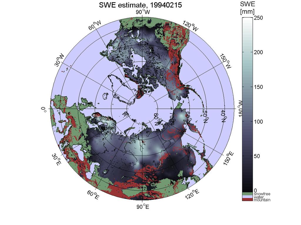
7 Version 0.92 SWE Product Daily maps of hemispherical snow cover: - Total snow area Permanent sesonal snow cover - SWE for the snow area Regions with high topograpical variability are masked off - Alpine regions - Glaciers will be also masked NRT production of SWE will be demonstrated in
8
9 GlobSnow SWE Product Approach: Assimilation of satellite data with in situ observationsderived bckground field on snow depth. - Sufficient accuracy level on a global scale can be obtained Statistical error estimate produced for each grid cell. SWE retrievals for all terrestrial snow regions of northern hemisphere excluding alpine regions and glaciers. Time-series currently under processing extending from 1978 to present Operational near-real-time service will be demonstrated during 2010/2011.
10
11
12
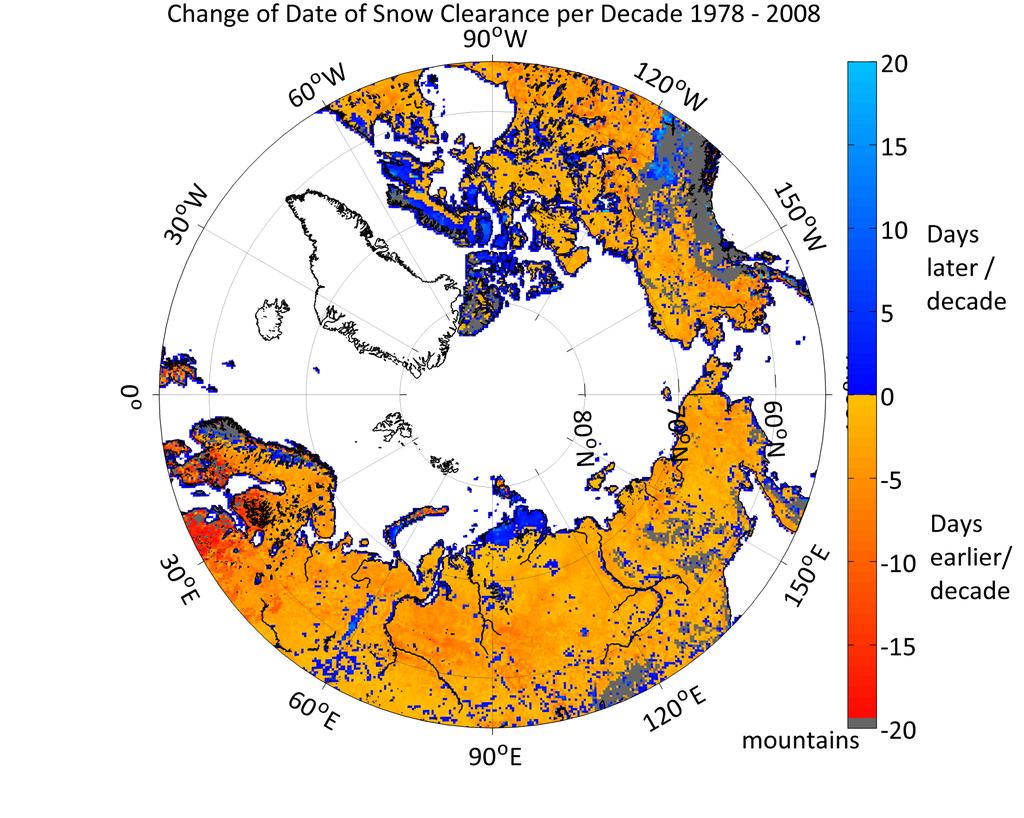
13 Day of snow clearance derived from GlobSnow product (Julian day from the beginning of the year)
14


 INTAS-SCONE data")
15 Example on Trend Analysis Change in snow clearance date in days/decade Satellite retrieval ECHAM5 (Obs. SST) INTAS-SCONE data Melts earlier Melts later
16 Possibilities to improve passive retrievals (I) Improved consideration of mixed pixels - Especially lake ice covered by snow has a major effect on microwave radiometer observations - SAR data used as forcing to a simple lake ice model may significantly improve the modeling of brightness temperature, and thus SWE retrieval for land areas


17 Effect of lake ice on passive satellite scenery Water bodies affect observed Tb: Differing background emission Differing snow cover properties Observed AMSR-E 18 GHz V pol Simulated 18 GHz V pol, multilayer HUT model Land and lake ice snow cover simulated based on in situ obs Lakes simulated separately as multiple layer structure (water-ice-snow) Fractional lake cover accounted for in each pixel Simulation error correlation with lake fraction CoReH2O Synergy Study PM1, Helsinki, FInland
18 Possibilities to improve passive retrievals (II) Resolution improvement (downscaling) by combining active and passive data - Current GlobSnow product does only yields coarse resolution estimates on SWE (scale of 25 km) - Fusion of higher resolution SAR data e.g. by iterative optimization algorithms - Can be used to improve the spatial accuracy of the GlobSnow SWE product M j j P k k w k k N i M j j i q j i i SWE M SWE T y y SWE Z x x SWE F , and ),, ( 2 1 ),, ( 2 1

19 Testing of downscaling for the Sodankylä site, northern Finland - Land cover and forest information processed to the resolution of 100 m - Using both simulated and real data - Accompanied with NoSREx campaign data Other Barren 800 Bogs Forests Water
20 Possibilities to improve passive retrievals (III) Snow-line and fractional snow cover during the melting period - SAR data applicable to produce this information independent of cloud conditions - Calibration and validation of global passive algorithms - Idea can be demonstrated using optical ENVISAT AATSR data-based GlobSnow product as reference to microwave data retrieved snow-line

21 SWE product-derived snow-line compared with GlobSnow AATSR SE 10-days composite (14 March 2003) CoReH2O can provide similar information as AATSR for snow-line and fractional snow cover area - Combined use - Calibration of passive products

22 SWE-product derived snow-line compared with SE 10-days composite (1 April 2003)
23 SWE product-derived snow-line compared with SE 10-days composite (18 April 2003)

24 Thank You for Your Attention!
ESA GlobSnow - project overview
 ESA GlobSnow - project overview GCW 1 st Implementation meeting Geneve, 23 Nov. 2011 K. Luojus & J. Pulliainen (FMI) + R. Solberg (NR) Finnish Meteorological Institute 1.12.2011 1 ESA GlobSnow ESA-GlobSnow
Soil frost from microwave data. Kimmo Rautiainen, Jouni Pulliainen, Juha Lemmetyinen, Jaakko Ikonen, Mika Aurela
 Soil frost from microwave data Kimmo Rautiainen, Jouni Pulliainen, Juha Lemmetyinen, Jaakko Ikonen, Mika Aurela Why landscape freeze/thaw? Latitudinal variation in mean correlations (r) between annual
Examples on Sentinel data applications in Finland, possibilities, plans and how NSDC will be utilized - Snow
 Examples on Sentinel data applications in Finland, possibilities, plans and how NSDC will be utilized - Snow Kari Luojus, Jouni Pulliainen, Jyri Heilimo, Matias Takala, Juha Lemmetyinen, Ali Arslan, Timo
Assimilation of GlobSnow Data in HIRLAM. Suleiman Mostamandy Kalle Eerola Laura Rontu Katya Kourzeneva
 Assimilation of GlobSnow Data in HIRLAM Suleiman Mostamandy Kalle Eerola Laura Rontu Katya Kourzeneva 10/03/2011 Contents Introduction Snow from satellites Globsnow Other satellites The current study Experiment
Copernicus Global Land Service
 Copernicus Global Land Service Cryosphere Products Kari Luojus on behalf the consortium Follow us on: Copernicus EU CopernicusEU www.copernicus.eu Copernicus Services Land Marine Atmosphere Emergency Security
Environmental observations over Arctic areas potential for monitoring the spread of infectious diseases
 Environmental observations over Arctic areas potential for monitoring the spread of infectious diseases Ali Nadir Arslan ali.nadir.arslan@fmi.fi ARCTIC RESEARCH DEAPARTMENT / FMI ARKTIKO Seminar, Helsinki,
Regional Activities and Perspectives on GCW: Relevant FMI Activities at Northern Finland and Suggestions for GCW Monitoring Site Requirements
 Regional Activities and Perspectives on GCW: Relevant FMI Activities at Northern Finland and Suggestions for GCW Monitoring Site Requirements Jouni Pulliainen 21 November 2011 Suggestions for GCW monitoring
FMI Arctic Space Centre. Jyri Heilimo Finnish Meteorological Institute
 FMI Arctic Space Centre Jyri Heilimo Finnish Meteorological Institute FMI - Arctic Space Center Studies of atmospheric phenomena and their interaction with biosphere and cryosphere in high latitudes Hydrology,
Remote sensing of snow at SYKE Sari Metsämäki
 Remote sensing of snow at SYKE 2011-01-21 Sari Metsämäki Activities in different projects Snow extent product in ESA DUE-project GlobSnow Long term datasets (15-30 years) on Snow Extent (SE) and Snow Water
ASSESSMENT OF NORTHERN HEMISPHERE SWE DATASETS IN THE ESA SNOWPEX INITIATIVE
 ASSESSMENT OF NORTHERN HEMISPHERE SWE DATASETS IN THE ESA SNOWPEX INITIATIVE Kari Luojus 1), Jouni Pulliainen 1), Matias Takala 1), Juha Lemmetyinen 1), Chris Derksen 2), Lawrence Mudryk 2), Michael Kern
The use of earth observation technology to improve the characterization of ice and snow
 The use of earth observation technology to improve the characterization of ice and snow Swedish Meteorological and Hydrological Institute (SMHI) Outline: EO and ice/snow CryoLand North Hydrology EO in
The indicator can be used for awareness raising, evaluation of occurred droughts, forecasting future drought risks and management purposes.
 INDICATOR FACT SHEET SSPI: Standardized SnowPack Index Indicator definition The availability of water in rivers, lakes and ground is mainly related to precipitation. However, in the cold climate when precipitation
Global Snow Monitoring for Climate Research. Final Report (FR) EUROPEAN SPACE AGENCY STUDY CONTRACT REPORT ESRIN Contract 21703/08/I-EC
 EUROPEAN SPACE AGENCY STUDY CONTRACT REPORT ESRIN Contract 21703/08/I-EC") Global Snow Monitoring for Climate Research Final Report (FR) EUROPEAN SPACE AGENCY STUDY CONTRACT REPORT ESRIN Contract DELIVERABLE 3.5 PREPARED BY Kari LUOJUS, Jouni PULLIAINEN, Matias TAKALA, Juha LEMMETYINEN
Global Snow Monitoring for Climate Research Final Report (FR) EUROPEAN SPACE AGENCY STUDY CONTRACT REPORT ESRIN Contract DELIVERABLE 3.5 PREPARED BY Kari LUOJUS, Jouni PULLIAINEN, Matias TAKALA, Juha LEMMETYINEN
Remote Sensing of SWE in Canada
 Remote Sensing of SWE in Canada Anne Walker Climate Research Division, Environment Canada Polar Snowfall Hydrology Mission Workshop, June 26-28, 2007 Satellite Remote Sensing Snow Cover Optical -- Snow
ADVANCEMENTS IN SNOW MONITORING
 Polar Space Task Group ADVANCEMENTS IN SNOW MONITORING Thomas Nagler, ENVEO IT GmbH, Innsbruck, Austria Outline Towards a pan-european Multi-sensor Snow Product SnowPEx Summary Upcoming activities SEOM
SIMULATION OF SPACEBORNE MICROWAVE RADIOMETER MEASUREMENTS OF SNOW COVER FROM IN-SITU DATA AND EMISSION MODELS
 SIMULATION OF SPACEBORNE MICROWAVE RADIOMETER MEASUREMENTS OF SNOW COVER FROM IN-SITU DATA AND EMISSION MODELS Anna Kontu 1 and Jouni Pulliainen 1 1. Finnish Meteorological Institute, Arctic Research,
Helsinki Testbed - a contribution to NASA's Global Precipitation Measurement (GPM) mission
 mission") Helsinki Testbed - a contribution to NASA's Global Precipitation Measurement (GPM) mission Ubicasting workshop, September 10, 2008 Jarkko Koskinen, Jarmo Koistinen, Jouni Pulliainen, Elena Saltikoff, David
Helsinki Testbed - a contribution to NASA's Global Precipitation Measurement (GPM) mission Ubicasting workshop, September 10, 2008 Jarkko Koskinen, Jarmo Koistinen, Jouni Pulliainen, Elena Saltikoff, David
Observing Snow: Conventional Measurements, Satellite and Airborne Remote Sensing. Chris Derksen Climate Research Division, ECCC
 Observing Snow: Conventional Measurements, Satellite and Airborne Remote Sensing Chris Derksen Climate Research Division, ECCC Outline Three Snow Lectures: 1. Why you should care about snow 2. How we measure
ESA snow monitoring initiatives
 ESA snow monitoring initiatives Bojan R. Bojkov Head, Sensor Performance, Products and Algorithms (SPPA) Directorate of Earth Observation Programmes ESA/ESRIN Why snow at ESA? Downstream services ESA instrument
Algorithm Theoretical Basis Document SWE-algorithm
 Global Snow Monitoring for Climate Research Algorithm Theoretical Basis Document SWE-algorithm EUROPEAN SPACE AGENCY STUDY CONTRACT REPORT ESRIN Contract DELIVERABLE 06 PREPARED BY KARI LUOJUS, JOUNI PULLIAINEN,
Snow Cover Applications: Major Gaps in Current EO Measurement Capabilities
 Snow Cover Applications: Major Gaps in Current EO Measurement Capabilities Thomas NAGLER ENVEO Environmental Earth Observation IT GmbH INNSBRUCK, AUSTRIA Polar and Snow Cover Applications User Requirements
H-SAF Snow products and their use in applications. Matias Takala
 H-SAF Snow products and their use in applications Matias Takala Matias.takala@fmi.fi H-SAF snow products H-SAF: EUMETSAT funded satellite application facility (SAF) for Support to Operational Hydrology
Climate Models and Snow: Projections and Predictions, Decades to Days
 Climate Models and Snow: Projections and Predictions, Decades to Days Outline Three Snow Lectures: 1. Why you should care about snow 2. How we measure snow 3. Snow and climate modeling The observational
Climate Change and Water Cycle: Effect to Water Resources and their Utilization in Finland (CLIMWATER)
") Climate Change and Water Cycle: Effect to Water Resources and their Utilization in Finland (CLIMWATER) Final Seminar of the Ficca Programme 2.12.2014 J. Pulliainen (FMI), L. Backman, J. Kaurola, T. Olsson,
Climate Change and Water Cycle: Effect to Water Resources and their Utilization in Finland (CLIMWATER) Final Seminar of the Ficca Programme 2.12.2014 J. Pulliainen (FMI), L. Backman, J. Kaurola, T. Olsson,
GlobSnow-2 Final Report
 Global Snow Monitoring for Climate Research GlobSnow-2 Final Report EUROPEAN SPACE AGENCY STUDY CONTRACT REPORT ESRIN Contract PREPARED BY KARI LUOJUS, JOUNI PULLIAINEN, MATIAS TAKALA, JUHA LEMMETYINEN,
Dual-Frequency Ku- Band Radar Mission Concept for Snow Mass
 Dual-Frequency Ku- Band Radar Mission Concept for Snow Mass Chris Derksen Environment and Climate Change Canada Study Team: Climate Research Division/Meteorological Research Division, ECCC Canadian Space
Satellite-based Lake Surface Temperature (LST) Homa Kheyrollah Pour Claude Duguay
 Homa Kheyrollah Pour Claude Duguay") Satellite-based Lake Surface Temperature (LST) Homa Kheyrollah Pour Claude Duguay Lakes in NWP models Interaction of the atmosphere and underlying layer is the most important issue in climate modeling
Satellite-based Lake Surface Temperature (LST) Homa Kheyrollah Pour Claude Duguay Lakes in NWP models Interaction of the atmosphere and underlying layer is the most important issue in climate modeling
Validation of satellite derived snow cover data records with surface networks and m ulti-dataset inter-comparisons
 Validation of satellite derived snow cover data records with surface networks and m ulti-dataset inter-comparisons Chris Derksen Climate Research Division Environment Canada Thanks to our data providers:
Remote Sensing of Environment
 Remote Sensing of Environment 115 (2011) 3517 3529 Contents lists available at SciVerse ScienceDirect Remote Sensing of Environment journal homepage: www.elsevier.com/locate/rse Estimating northern hemisphere
Canadian Prairie Snow Cover Variability
 Canadian Prairie Snow Cover Variability Chris Derksen, Ross Brown, Murray MacKay, Anne Walker Climate Research Division Environment Canada Ongoing Activities: Snow Cover Variability and Links to Atmospheric
Snow from Space: Building a Vision
 Snow from Space: Building a Vision Jeff Deems, Chris Derksen, Michael Durand, Jared En?n, Ed Kim, Dennis LeBenmaier, Glen Liston, Noah Molotch, Anne Nolin, Tom Painter, MaBhew Sturm, Simon Yueh and YOU!
Intercomparison of Snow Extent Products from Earth Observation Data
 Intercomparison of Snow Extent Products from Earth Observation Data, Elisabeth Ripper, Gabriele Bippus, Helmut Rott FMI Richard Fernandes Kari Luojus Sari Metsämäki Dorothy Hall David Robinson Bojan Bojkov
Lake ice cover and surface water temperature II: Satellite remote sensing
 Lake ice cover and surface water temperature II: Satellite remote sensing Claude Duguay University of Waterloo (Canada) Earth Observation Summer School ESA-ESRIN, Frascati, Italy (4-14 August 2014) Lecture
SMOSIce L-Band Radiometry for Sea Ice Applications
 Institute of Environmental Physics University of Bremen SMOSIce L-Band Radiometry for Sea Ice Applications Georg Heygster 1), Christian Haas 2), Lars Kaleschke 3), Helge Rebhan 5), Detlef Stammer 3), Rasmus
LIFE12 ENV/FIN/ st summary report of snow data 30/09/2014
 LIFE Project Number 1st summary report of snow data Reporting Date 30/09/2014 LIFE+ PROJECT NAME or Acronym Climate change indicators and vulnerability of boreal zone applying innovative observation and
C o p e r n i c u s L a n d M o n i t o r i n g S e r v i c e
 C o p e r n i c u s L a n d M o n i t o r i n g S e r v i c e Integration into existing Snow and Ice Services and draft product specifications Annett BARTSCH b.geos Copernicus High Resolution Snow and
Snow maps based on satellite data
 Snow maps based on satellite data SNAPS Work Package 4: Final report on WP 4 Prepared by Eirik Malnes, Norut, Norway Kari Luojus, Jaakko Ikonen and Matias Takala, FMI, Finland Hrobjartur Thorsteinsson
Evaluation and Assimilation of Remotely- Sensed Lake Surface Temperature in the HIRLAM Weather Forecasting System
 Evaluation and Assimilation of Remotely- Sensed Lake Surface Temperature in the HIRLAM Weather Forecasting System H. Kheyrollah Pour 1, C.R. Duguay 1, L. Rontu 2 with contributions from Kalle Eerola 2,
Presentation of met.no s experience and expertise related to high resolution reanalysis
 Presentation of met.no s experience and expertise related to high resolution reanalysis Oyvind Saetra, Ole Einar Tveito, Harald Schyberg and Lars Anders Breivik Norwegian Meteorological Institute Daily
EUMeTrain Snow Week 2010 Session 3 (MRG069305) (MRG069305)
 (MRG069305)") EUMeTrain Snow Week 2010 Session 3 (MRG069305) Event Name: Subject Name: Leader: Start Time: End Time: EUMeTrain Snow Week 2010 Session 3 (MRG069305) (MRG069305) Vesa Nietosvaara (Vesa) 2/3/10 2:00 pm
EUMeTrain Snow Week 2010 Session 3 (MRG069305) Event Name: Subject Name: Leader: Start Time: End Time: EUMeTrain Snow Week 2010 Session 3 (MRG069305) (MRG069305) Vesa Nietosvaara (Vesa) 2/3/10 2:00 pm
Snow and Albedo as Essential Climate Variables
 Snow and Albedo as Essential Climate Variables Jason E. Box Geological Survey of Denmark and Greenland Copenhagen, Denmark current (alphabetical) national collaboration 1.Liège, Belgium 2.Copenhagen, Denmark
THE WINTER season land cover in Finland and large portions
 IEEE TRANSACTIONS ON GEOSCIENCE AND REMOTE SENSING, VOL. 47, NO. 3, MARCH 2009 965 A Comparison of Airborne Microwave Brightness Temperatures and Snowpack Properties Across the Boreal Forests of Finland
Remote Sensing of Environment
 Remote Sensing of Environment 117 (2012) 236 248 Contents lists available at SciVerse ScienceDirect Remote Sensing of Environment journal homepage: www.elsevier.com/locate/rse Evaluation of passive microwave
Copernicus Land Monitoring Services
 Copernicus Land Monitoring Services TASK 3: CONTINUATION OF SNOW & ICE TASK D 3.2: Summary Report to Support EEA Date: June 2017 Version: 1.0 Prepared by: Marketa Jindrova (GISAT) Joan Bauzà Llinàs Alaitz
III. Publication III. c 2004 Authors
 III Publication III J-P. Kärnä, J. Pulliainen, K. Luojus, N. Patrikainen, M. Hallikainen, S. Metsämäki, and M. Huttunen. 2004. Mapping of snow covered area using combined SAR and optical data. In: Proceedings
Arctic Regional Ocean Observing System Arctic ROOS Report from 2012
 Arctic Regional Ocean Observing System Arctic ROOS Report from 2012 By Stein Sandven Nansen Environmental and Remote Sensing Center (www.arctic-roos.org) Focus in 2012 1. Arctic Marine Forecasting Center
Studying snow cover in European Russia with the use of remote sensing methods
 40 Remote Sensing and GIS for Hydrology and Water Resources (IAHS Publ. 368, 2015) (Proceedings RSHS14 and ICGRHWE14, Guangzhou, China, August 2014). Studying snow cover in European Russia with the use
The ESA SnowPex project and an introduction to the APVE workshops
 The ESA SnowPex project and an introduction to the APVE workshops Bojan R. Bojkov Head Sensor Performance, Products and Algorithms Directorate of Earth Observation Programmes European Space Agency ESA/ESRIN
Merged sea-ice thickness product from complementary L-band and altimetry information
 Merged sea-ice thickness product from complementary L-band and altimetry information Contributors AWI Team Stefan Hendricks Robert Ricker Stephan Paul University Hamburg Team Lars Kaleschke Xiangshan Tian-Kunze
H SAF SATELLITE APPLICATION FACILITY ON SUPPORT TO OPERATIONAL HYDROLOGY AND WATER MANAGEMENT EUMETSAT NETWORK OF SATELLITE APPLICATION FACILITIES
 H SAF SATELLITE APPLICATION FACILITY ON SUPPORT TO OPERATIONAL HYDROLOGY AND WATER MANAGEMENT EUMETSAT NETWORK OF SATELLITE APPLICATION FACILITIES H-SAF: SATELLITE PRODUCTS FOR OPERATIONAL HYDROLOGY H-SAF
The Canadian Land Data Assimilation System (CaLDAS)
") The Canadian Land Data Assimilation System (CaLDAS) Marco L. Carrera, Stéphane Bélair, Bernard Bilodeau and Sheena Solomon Meteorological Research Division, Environment Canada Dorval, QC, Canada 2 nd Workshop
The Canadian Land Data Assimilation System (CaLDAS) Marco L. Carrera, Stéphane Bélair, Bernard Bilodeau and Sheena Solomon Meteorological Research Division, Environment Canada Dorval, QC, Canada 2 nd Workshop
Development of the Canadian Precipitation Analysis (CaPA) and the Canadian Land Data Assimilation System (CaLDAS)
 and the Canadian Land Data Assimilation System (CaLDAS)") Development of the Canadian Precipitation Analysis (CaPA) and the Canadian Land Data Assimilation System (CaLDAS) Marco L. Carrera, Vincent Fortin and Stéphane Bélair Meteorological Research Division Environment
Development of the Canadian Precipitation Analysis (CaPA) and the Canadian Land Data Assimilation System (CaLDAS) Marco L. Carrera, Vincent Fortin and Stéphane Bélair Meteorological Research Division Environment
EUMETSAT SAF NETWORK. Lothar Schüller, EUMETSAT SAF Network Manager
 1 EUMETSAT SAF NETWORK Lothar Schüller, EUMETSAT SAF Network Manager EUMETSAT ground segment overview METEOSAT JASON-2 INITIAL JOINT POLAR SYSTEM METOP NOAA SATELLITES CONTROL AND DATA ACQUISITION FLIGHT
THE ROLE OF MICROSTRUCTURE IN FORWARD MODELING AND DATA ASSIMILATION SCHEMES: A CASE STUDY IN THE KERN RIVER, SIERRA NEVADA, USA
 MICHAEL DURAND (DURAND.8@OSU.EDU), DONGYUE LI, STEVE MARGULIS Photo: Danielle Perrot THE ROLE OF MICROSTRUCTURE IN FORWARD MODELING AND DATA ASSIMILATION SCHEMES: A CASE STUDY IN THE KERN RIVER, SIERRA
From L1 to L2 for sea ice concentration. Rasmus Tonboe Danish Meteorological Institute EUMETSAT OSISAF
 From L1 to L2 for sea ice concentration Rasmus Tonboe Danish Meteorological Institute EUMETSAT OSISAF Sea-ice concentration = sea-ice surface fraction Water Ice e.g. Kern et al. 2016, The Cryosphere
Assimilating AMSU-A over Sea Ice in HIRLAM 3D-Var
 Abstract Assimilating AMSU-A over Sea Ice in HIRLAM 3D-Var Vibeke W. Thyness 1, Leif Toudal Pedersen 2, Harald Schyberg 1, Frank T. Tveter 1 1 Norwegian Meteorological Institute (met.no) Box 43 Blindern,
Advancements and validation of the global CryoClim snow cover extent product
 www.nr.no Advancements and validation of the global CryoClim snow cover extent product Rune Solberg1, Øystein Rudjord1, Arnt-Børre Salberg1 and Mari Anne Killie2 1) Norwegian Computing Center (NR), P.O.
THE USE OF MERIS SPECTROMETER DATA IN SEASONAL SNOW MAPPING
 THE USE OF MERIS SPECTROMETER DATA IN SEASONAL SNOW MAPPING Miia Eskelinen, Sari Metsämäki The Finnish Environment Institute Geoinformatics and Land use division P.O.Box 140, FI 00251 Helsinki, Finland
Permafrost: Earth Observation Applications: Introduction
 Polar Meeting 3 Permafrost: Earth Observation Applications: Introduction Mark Drinkwater CNES, Paris, 22 23 May, 2013 Remote Sensing of Permafrost which Remote Sensing products? applicability to Permafrost
Floating Ice: Progress in Addressing Science Goals
 Polar Floating Ice: Progress in Addressing Science Goals Stephen Howell 1, Leif Toudal Pedersen 2 and Roberto Saldo 3 1 Environment Canada, Climate Research Division, Toronto, Canada 2 Danish Meteorological
Observation Operators for sea ice thickness to L-band brightness temperatures
 Observation Operators for sea ice thickness to L-band brightness temperatures F. Richter, M. Drusch, L. Kaleschke, N. Maass, X. Tian-Kunze, G. Heygster, S. Mecklenburg, T. Casal, and many others ESA, ESTEC
PROGRESS IN ADDRESSING SCIENCE GOALS FOR SNOW MONITORING BY MEANS OF SAR
 Polar Space Task Group PROGRESS IN ADDRESSING SCIENCE GOALS FOR SNOW MONITORING BY MEANS OF SAR Thomas Nagler, Helmut Rott, ENVEO IT GmbH, Innsbruck, Austria SNOW: Observational Requirements and SAR Products
Discritnination of a wet snow cover using passive tnicrowa ve satellite data
 Annals of Glaciology 17 1993 International Glaciological Society Discritnination of a wet snow cover using passive tnicrowa ve satellite data A. E. WALKER AND B. E. GOODISON Canadian Climate Centre, 4905
EUMETSAT SAF NETWORK. Lothar Schüller, EUMETSAT SAF Network Manager
 1 EUMETSAT SAF NETWORK Lothar Schüller, EUMETSAT SAF Network Manager EUMETSAT ground segment overview METEOSAT JASON-2 INITIAL JOINT POLAR SYSTEM METOP NOAA SATELLITES CONTROL AND DATA ACQUISITION FLIGHT
Assimilation of Globsnow data into HIRLAM. Mostamandy Suleiman Sodankyla August 2011
 Assimilation of Globsnow data into HIRLAM Mostamandy Suleiman Sodankyla August 2011 Motivation Small number of observations (especially in eastern Europe and Russia) 00 cm of snow problem Non-uniform in
ASimultaneousRadiometricand Gravimetric Framework
 Towards Multisensor Snow Assimilation: ASimultaneousRadiometricand Gravimetric Framework Assistant Professor, University of Maryland Department of Civil and Environmental Engineering September 8 th, 2014
Assimilation of Snow and Ice Data (Incomplete list)
") Assimilation of Snow and Ice Data (Incomplete list) Snow/ice Sea ice motion (sat): experimental, climate model Sea ice extent (sat): operational, U.S. Navy PIPs model; Canada; others? Sea ice concentration
Assimilation of Snow and Ice Data (Incomplete list) Snow/ice Sea ice motion (sat): experimental, climate model Sea ice extent (sat): operational, U.S. Navy PIPs model; Canada; others? Sea ice concentration
Determination of the snow melting intensity in nowadays climate conditions by example of the Neman river basin
 Determination of the snow melting intensity in nowadays climate conditions by example of the Neman river basin Alexander Volchak, Dmitriy Kostiuk, Dmitriy Petrov, Nikolay Sheshko Brest State Technical
ECMWF. ECMWF Land Surface Analysis: Current status and developments. P. de Rosnay M. Drusch, K. Scipal, D. Vasiljevic G. Balsamo, J.
 Land Surface Analysis: Current status and developments P. de Rosnay M. Drusch, K. Scipal, D. Vasiljevic G. Balsamo, J. Muñoz Sabater 2 nd Workshop on Remote Sensing and Modeling of Surface Properties,
Remote sensing with FAAM to evaluate model performance
 Remote sensing with FAAM to evaluate model performance YOPP-UK Workshop Chawn Harlow, Exeter 10 November 2015 Contents This presentation covers the following areas Introduce myself Focus of radiation research
SMAP and SMOS Integrated Soil Moisture Validation. T. J. Jackson USDA ARS
 SMAP and SMOS Integrated Soil Moisture Validation T. J. Jackson USDA ARS Perspective Linkage of SMOS and SMAP soil moisture calibration and validation will have short and long term benefits for both missions.
C. Jimenez, C. Prigent, F. Aires, S. Ermida. Estellus, Paris, France Observatoire de Paris, France IPMA, Lisbon, Portugal
 All-weather land surface temperature estimates from microwave satellite observations, over several decades and real time: methodology and comparison with infrared estimates C. Jimenez, C. Prigent, F. Aires,
WMO RA VI Hydrological Forum. H-SAF: from products to end users
 WMO RA VI Hydrological Forum Oslo, 20 September 2016 H-SAF: from products to end users Lt. Col. Francesco Zauli ITAF-COMet H-SAF Project Manager 1 H-SAF Objectives Satellite Application Facility in Support
OSI SAF Sea Ice products
 OSI SAF Sea Ice products Lars-Anders Brevik, Gorm Dybkjær, Steinar Eastwood, Øystein Godøy, Mari Anne Killie, Thomas Lavergne, Rasmus Tonboe, Signe Aaboe Norwegian Meteorological Institute Danish Meteorological
Summary The present report describes one possible way to correct radiometric measurements of the SSM/I (Special Sensor Microwave Imager) at 85.5 GHz f
 at 85.5 GHz f") Compensating for atmospheric eects on passive radiometry at 85.5 GHz using a radiative transfer model and NWP model data Stefan Kern Institute of Environmental Physics University of Bremen, 28334 Bremen,
Compensating for atmospheric eects on passive radiometry at 85.5 GHz using a radiative transfer model and NWP model data Stefan Kern Institute of Environmental Physics University of Bremen, 28334 Bremen,
ECMWF. ECMWF Land Surface modelling and land surface analysis. P. de Rosnay G. Balsamo S. Boussetta, J. Munoz Sabater D.
 Land Surface modelling and land surface analysis P. de Rosnay G. Balsamo S. Boussetta, J. Munoz Sabater D. Vasiljevic M. Drusch, K. Scipal SRNWP 12 June 2009 Slide 1 Surface modelling (G. Balsamo) HTESSEL,
User requirements for the snow and land ice services CryoLand
 doi:10.5194/tc-9-1191-2015 Author(s) 2015. CC Attribution 3.0 License. User requirements for the snow and land ice services CryoLand E. Malnes 1, A. Buanes 1, T. Nagler 2, G. Bippus 2, D. Gustafsson 3,
Advancing Remote-Sensing Methods for Monitoring Geophysical Parameters
 Advancing Remote-Sensing Methods for Monitoring Geophysical Parameters Christian Mätzler (Retired from University of Bern) Now consultant for Gamma Remote Sensing, Switzerland matzler@iap.unibe.ch TERENO
The Satellite Snow Product Intercomparison and Evaluation Experiment Objectives, Status, Expected Results
 SnowPEx Satellite Snow Product Intercomparison and Evaluation Experiment (6/2014 5/2016) The Satellite Snow Product Intercomparison and Evaluation Experiment Objectives, Status, Expected Results Thomas
Recent Data Assimilation Activities at Environment Canada
 Recent Data Assimilation Activities at Environment Canada Major upgrade to global and regional deterministic prediction systems (now in parallel run) Sea ice data assimilation Mark Buehner Data Assimilation
Snow on sea ice retrieval using microwave radiometer data. Rasmus Tonboe and Lise Kilic Danish Meteorological Institute Observatoire de Paris
 Snow on sea ice retrieval using microwave radiometer data Rasmus Tonboe and Lise Kilic Danish Meteorological Institute Observatoire de Paris We know something about snow The temperature gradient within
Artificial neural network-based techniques for the retrieval of SWE and snow depth from SSM/I data
 Remote Sensing of Environment 90 (2004) 76 85 www.elsevier.com/locate/rse Artificial neural network-based techniques for the retrieval of SWE and snow depth from SSM/I data M. Tedesco a, *, J. Pulliainen
Improvement of objective analysis of lake surface state in HIRLAM using satellite observations
 HIRLAM ASM 2013 & ALADIN 23 rd Workshop Reykjavik, Iceland 15-19 April, 2013 Improvement of objective analysis of lake surface state in HIRLAM using satellite observations H. Kheyrollah Pour, C.R. Duguay
/$ IEEE
 2996 IEEE TRANSACTIONS ON GEOSCIENCE AND REMOTE SENSING, VOL. 47, NO. 9, SEPTEMBER 2009 Detection of Snowmelt Using Spaceborne Microwave Radiometer Data in Eurasia From 1979 to 2007 Matias Takala, Jouni
Modelling and Data Assimilation Needs for improving the representation of Cold Processes at ECMWF
 Modelling and Data Assimilation Needs for improving the representation of Cold Processes at ECMWF presented by Gianpaolo Balsamo with contributions from Patricia de Rosnay, Richard Forbes, Anton Beljaars,
National Satellite Data Centre and Finnish Sentinel Collaborative Ground Segment. Jyri Heilimo Finnish Meteorological Instute
 National Satellite Data Centre and Finnish Sentinel Collaborative Ground Segment Jyri Heilimo Finnish Meteorological Instute Sodankylä National Satellite Data Centre National satellite data centre providing
ECMWF snow data assimilation: Use of snow cover products and In situ snow depth data for NWP
 snow data assimilation: Use of snow cover products and In situ snow depth data for NWP Patricia de Rosnay Thanks to: Ioannis Mallas, Gianpaolo Balsamo, Philippe Lopez, Anne Fouilloux, Mohamed Dahoui, Lars
Intercomparison and Evaluation Experiment
 The SnowPEx Satellite Satellite Snow Product Intercomparison Snow and Evaluation Experiment Product (6/2014 5/2016) Intercomparison and Evaluation Experiment Report to PSTG WG Meeting # 5 DLR, 5 Oct 2015
Pan-Arctic Land and Lake Surface Temperature from AATSR and MODIS: Products Development and Evaluation
 Pan-Arctic Land and Lake Surface Temperature from AATSR and MODIS: Products Development and Evaluation Homa Kheyrollah Pour Claude Duguay University of Waterloo 1 st Arctic Products Validation & Evolution
Validation of passive microwave snow algorithms
 Remote Sensing and Hydrology 2000 (Proceedings of a symposium held at Santa Fe, New Mexico, USA, April 2000). IAHS Publ. no. 267, 2001. 87 Validation of passive microwave snow algorithms RICHARD L. ARMSTRONG
Polar Regions and Cryosphere Monitoring from Space: Future Outlook. P. Silvestrin EOP-SF ESA ESTEC
 Polar Regions and Cryosphere Monitoring from Space: Future Outlook P. Silvestrin EOP-SF ESA ESTEC Programmatic Context Copernicus Evolution now top of agenda, seen over two time horizons (services extension
LANDSAF SNOW COVER MAPPING USING MSG/SEVIRI DATA
 LANDSAF SNOW COVER MAPPING USING MSG/SEVIRI DATA Niilo Siljamo and Otto Hyvärinen Finnish Meteorological Institute, Erik Palménin aukio 1, P.O.Box 503, FI-00101 Helsinki, Finland Abstract Land Surface
REMOTE SENSING OF PERMAFROST IN NORTHERN ENVIRONMENTS
 REMOTE SENSING OF PERMAFROST IN NORTHERN ENVIRONMENTS What is permafrost? What can we monitor with satellite data? Permafrost is an Essential Climate Variable About 25 % of the land surface is underlain
Monitoring the frozen duration of Qinghai Lake using satellite passive microwave remote sensing low frequency data
 Chinese Science Bulletin 009 SCIENCE IN CHINA PRESS ARTICLES Springer Monitoring the frozen duration of Qinghai Lake using satellite passive microwave remote sensing low frequency data CHE Tao, LI Xin
Assimilation of land surface satellite data for Numerical Weather Prediction at ECMWF
 4 th workshop on Remote Sensing and Modelling of Surface properties Saint Martin d Hères, 14-16 March 2016 Assimilation of land surface satellite data for Numerical Weather Prediction at ECMWF P. de Rosnay,
Land Data Assimilation for operational weather forecasting
 Land Data Assimilation for operational weather forecasting Brett Candy Richard Renshaw, JuHyoung Lee & Imtiaz Dharssi * *Centre Australian Weather and Climate Research Contents An overview of the Current
Towards the use of SAR observations from Sentinel-1 to study snowpack properties in Alpine regions
 Towards the use of SAR observations from Sentinel-1 to study snowpack properties in Alpine regions Gaëlle Veyssière, Fatima Karbou, Samuel Morin et Vincent Vionnet CNRM-GAME /Centre d Etude de la Neige
VALIDATION RESULTS OF THE OPERATIONAL LSA-SAF SNOW COVER MAPPING
 VALIDATION RESULTS OF THE OPERATIONAL LSA-SAF SNOW COVER MAPPING Niilo Siljamo, Otto Hyvärinen Finnish Meteorological Institute, Erik Palménin aukio 1, P.O.Box 503, FI-00101 HELSINKI Abstract Hydrological
CryoLand. GMES Service Snow and Land Ice. Collaborative Project funded by the European Union under the 7th Framework Programme Project Number:
 CryoLand GMES Service Snow and Land Ice Collaborative Project funded by the European Union under the 7th Framework Programme Project Number: 262925 Prepared by Eirik Malnes and Arild Buanes, Norut, Norway
Snow property extraction based on polarimetry and differential SAR interferometry
 Snow property extraction based on polarimetry and differential SAR interferometry S. Leinß, I. Hajnsek Earth Observation and Remote Sensing, Institute of Enviromental Science, ETH Zürich TerraSAR X and