Floating Ice: Progress in Addressing Science Goals
|
|
|
- Alisha Casey
- 5 years ago
- Views:
Transcription


1 Polar Floating Ice: Progress in Addressing Science Goals Stephen Howell 1, Leif Toudal Pedersen 2 and Roberto Saldo 3 1 Environment Canada, Climate Research Division, Toronto, Canada 2 Danish Meteorological Institute, Copenhagen, Denmark 3 Technical University of Denmark, Denmark PSTG SAR CWG-4 Meeting, DLR, 8-9 Oct., 2015
2 Outline 1. Scientific requirements for studying floating ice 2. Sentinel-1A Progress Update 3. Science Highlights 4. Science Gaps 5. Future Planning
3 Outline 1. Scientific requirements for studying floating ice 2. Sentinel-1A Progress Update 3. Science Highlights 4. Science Gaps 5. Future Planning
4 Scientific requirements for studying floating 1. Establish a multi-agency plan for acquiring contiguous (seamless) six days repeat pan- Arctic SAR imaging at consistent polarization combination with view to expanding to an intermediate goal of less than three days repeat in future with rightlooking Sentinel-1 (S-1), RADARSAT Constellation Mission (RCM), etc.; and subsequently sub-daily data with C-, X-, S-, L-band SAR combined data sources
5 Scientific requirements for studying floating 2. Establish Arctic Tundra lakes and river monitoring sites, as extension of sea ice coverage. 3. Assure continuity in all-weather ice concentration, extent, motion and thickness data in support of the sea ice climate data time to secure the sea ice Essential Climate Variable (GCOS, 2010)


6 Scientific requirements for studying floating 4. Coordinate with field campaigns, ice camps and drifting buoys to maximise synergies and product validation possibilities (and uncertainty estimates).
7 Outline 1. Scientific requirements for studying floating ice 2. Sentinel-1A Progress Update 3. Science Highlights 4. Science Gaps 5. Future Planning


8 First ice chart from Sentinel-1A data Sentinel-1a was launched in April 2014 The first Sentinel-1 sea-ice chart was drawn by DMI S1A image :10 UTC, EWS, HH


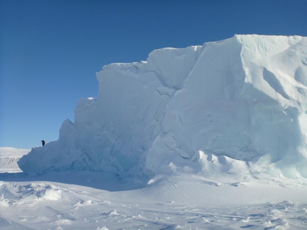
9 Iceberg detection (Disko Bay example) Icebergs in Disko Bay, Sentinel 1A, :10 UTC, EWS, HH+HV Icebergs show up pink, sea-ice in bluish colors when using dual polarisation Single pol HH Dual pol HH+HV Jakobshavn glacier pouring icebergs into Disko Bay Zoom into sea ice and iceberg mix Icebergs are pink in dual pol composite
 The red dots are detected icebergs, and the numbers in the frames show number of hours since last S1A image of the area Some of the potential icebergs may be ships, the")
10 Potential icebergs Daily Sentinel-1A Iceberg maps DMI delivers maps of iceberg density on a 10x10 kilometer grid to Copernicus With the availability of Sentinel-1 we have developed a daily iceberg map product (see figure) The red dots are detected icebergs, and the numbers in the frames show number of hours since last S1A image of the area Some of the potential icebergs may be ships, the detection algorithm cannot distinguish

11 Ice drift from Sentinel-1 Sentinel-1 coverage on September 30, 2015 and ice drift vectors between September 29 and 30 ENVISAT ASAR data allowed development of methods and derivation of daily maps of ice drift in the Arctic HH polarization desired and sufficient Satellite SAR data enables ice drift determination all year round, other satellite ice drift products only available during Winter Sentinel-1A now provides daily ice drift data for a large part of the Arctic Around 70+ S1A scenes per day acquired over sea ice covered areas in Northern Hemisphere
12 Outline 1. Scientific requirements for studying floating ice 2. Sentinel-1A Progress Update 3. Science Highlights 4. Science Gaps 5. Future Planning


13 NASA Operation IceBridge and RADARSAT-2 NASA's Operational IceBridge (OIB) conducts extensive airborne surveys of Earth's polar ice to bridge the gap between (Ice, Cloud, and land Elevation Satellite (ICESat-1; ) and ICESat-2 (2017). Of primary interest to the sea ice community are the ice thickness and snow depth on sea ice NO SAR support


14 NASA Operation IceBridge and RADARSAT day coverage of OIB sea ice domain from RADARSAT scenes for 2014; 762 scenes for 2015 Used for field validation and preflight planning


15 NASA Operation IceBridge and RADARSAT-2 Co-ordinated with ground team. Another major campaign scheduled for March 2016


16 NASA Operation IceBridge and RADARSAT-2 Validating OIB snow on sea ice product King et al., in review

17 Science Highlights: Invisible Polynyas Jones Sound Feb 10, 2013 Melling et al JGR


18 Science Highlights: Invisible Polynyas Synergy needed to find these polynyas Melling et al JGR


19 Science Highlights: Ice Thickness in the Northwest Passage First ever airborne EM ice thickness survey of Northwest Passage Haas and Howell 2015-GRL
 provides the data background for development of next generation")

20 Satellite observations of ice drift vs Copernicus model forecasts Excellent coverage of European Arctic The capability of S1A(+B) provides the data background for development of next generation ice drift modules in Climate- and sea ice models. Efforts are underway in France, Belgium and Norway. Ice drift predicted by MyOcean (yellow), Ice drift observed by S1A (green), January

21 Ice drift vs Wind Two datasets of sea ice drift OSISAF AMSR-E ice drift MyOcean ENVISAT ASAR ice drift Analysis shows increase in ice drift to wind speed ratio over the last 10 years. Consistent with the ice having thinned substantially over the same period

22 Downstream Services See near real time updates of Sentinel-1, ASMR2, MODIS and Copernicus model data etc.


23 We already deliver Sentinel-1 SAR data directly to our users in Greenland and the images are very popular with the general public!! More than images per month downloaded by Greenland users
24 Outline 1. Scientific requirements for studying floating ice 2. Sentinel-1A Progress Update 3. Science Highlights 4. Science Gaps 5. Future Planning


25 Polar Typical 1-day coverage September 2015 Sentinel-1A Northern Hemisphere Typical 3-day coverage September 2015


26 RADARSAT-2 and RCM Northern Hemisphere Daily coverage with RADARSAT-2 Daily coverage with RCM


27 Southern Hemisphere Typical 1-day coverage September 2015 Typical 3-day coverage September 2015
28 Southern Hemisphere In the Southern Hemisphere we need a combination of ascending and descending passes to get day to day overlap areas and be able to detect ice drift and deformation More than 2 satellites are needed to give Southern Hemisphere similar coverage to the North


29 We need automatic methods to process the 1000s of Sentinel-1 scenes into more user friendly products Today we derive ice information from SAR data by manual interpretation With the large number of SAR scenes we get from Sentinel-1 we need further automatic methods Not easy - SAR data are very noisy However, potential for much higher resolution products, and faster delivery
30 Automating SAR classification
31 Outline 1. Scientific requirements for studying floating ice 2. Sentinel-1A Progress Update 3. Science Highlights 4. Science Gaps 5. Future Planning
32 ICESat-2 Of wide interest to the science community Estimate sea ice thickness to examine ice/ocean/atmosphere exchanges of energy, mass and moisture Need RADARSAT-2, Sentinel-1A/1B and RCM (when launched) to ensure complete pan- Arctic coverage. Coordinate with Ron Kwok (Sea Ice Science Team lead)

33 ICESat-2 Retrieval of sea ice thickness Courtesy T. Markus
34 Thank You!
 2017-2019")
35 Seasonal Prediction Needs Year of Polar Prediction (YOPP)
Sentinel-1 Mission Status
 Sentinel-1 Mission Status Pierre Potin, Sentinel-1 Mission Manager, ESA Luca Martino, Technical Support Engineer, ESA... and the Sentinel-1 operations team PSTG SAR Coordination Working Group 14 December
Ice surveys, meteorological and oceanographic data What is available and up-to-date?
 Ice surveys, meteorological and oceanographic data What is available and up-to-date? Leader of the Norwegian Ice Service +47 77 62 13 15 - nick.hughes@met.no Norwegian Meteorological Institute met.no 1
Sentinel-1 Mission Status
 Sentinel-1 Mission Status Pierre Potin, Sentinel-1 Mission Manager 5TH GEOGLAM RAPP Workshop 16-17 May 2017, ESRIN Sentinel-1: Copernicus radar imaging mission for ocean, land, emergency Part of the Copernicus
QUALITY INFORMATION DOCUMENT For Arctic Ice Extent Indicator. ARC_SEAICE_INDEX_002
 QUALITY INFORMATION DOCUMENT For Arctic Ice Extent Indicator. Issue: 1.2 Contributors: Steinar Eastwood, Lars-Anders Breivik, Bruce Hackett, Thomas Lavergne, Gorm Dybkjær, Cecilie Wettre Approval Date
Infrastructure monitoring using SAR interferometry
 Infrastructure monitoring using SAR interferometry Hossein Nahavandchi Roghayeh Shamshiri Norwegian University of Science and Technology (NTNU), Department of Civil and Environmental Engineering Geodesy
Observing Arctic Sea Ice Change. Christian Haas
 Observing Arctic Sea Ice Change Christian Haas Decreasing Arctic sea ice extent in September Ice extent is decreasing, but regional patterns are very different every year The Cryosphere Today, http://arctic.atmos.uiuc.edu;
The Importance of Microwave Remote Sensing for Operational Sea Ice Services And Challenges
 The Importance of Microwave Remote Sensing for Operational Sea Ice Services And Challenges Wolfgang Dierking January 2015 (1) Why is microwave remote sensing important (=useful) for sea ice mapping? Problems
EUMETSAT STATUS AND PLANS
 1 EUM/TSS/VWG/15/826793 07/10/2015 EUMETSAT STATUS AND PLANS François Montagner, Marine Applications Manager, EUMETSAT WMO Polar Space Task Group 5 5-7 October 2015, DLR, Oberpfaffenhofen PSTG Strategic
Sea ice charts and SAR for sea ice classification. Patrick Eriksson Juha Karvonen Jouni Vainio
 Sea ice charts and SAR for sea ice classification Patrick Eriksson Juha Karvonen Jouni Vainio ECMWF Ocean Workshop, 22-25 January 2018 Ice service from past to present Finland has long experience in ice
Monitoring Sea Ice with Space-borne Synthetic Aperture Radar
 Monitoring Sea Ice with Space-borne Synthetic Aperture Radar Torbjørn Eltoft UiT- the Arctic University of Norway CIRFA A Centre for Research-based Innovation cirfa.uit.no Sea ice & climate Some basic
SAR Coordination for Snow Products
 Polar SAR Coordination Working Meeting 5 SAR Coordination for Snow Products David Small 1, Thomas Nagler 2, David Jäger 1, Christoph Rohner 1, Adrian Schubert 1 1: University of Zurich, Switzerland 2:
Remote sensing of sea ice
 Remote sensing of sea ice Ice concentration/extent Age/type Drift Melting Thickness Christian Haas Remote Sensing Methods Passive: senses shortwave (visible), thermal (infrared) or microwave radiation
Ocean & Sea Ice SAF. Validation of ice products January March Version 1.1. May 2005
 Ocean & Sea Ice SAF Validation of ice products January 2002 - March 2005 Version 1.1 May 2005 Morten Lind, Keld Q. Hansen, Søren Andersen 1 INTRODUCTION... 3 2 PRODUCTS VALIDATION METHODS... 3 3 GENERAL
SENTINEL 1 Mission status and contribution to PSTG
 PSTG SAR WG meeting, 12 September 2016, ESTEC SENTINEL 1 Mission status and contribution to PSTG First Sentinel1B Images 28 April 2016 Sentinel-1B Launch from Kourou, 25 April 2016 Sentinel 1 Mission Operations
Lake ice cover and surface water temperature II: Satellite remote sensing
 Lake ice cover and surface water temperature II: Satellite remote sensing Claude Duguay University of Waterloo (Canada) Earth Observation Summer School ESA-ESRIN, Frascati, Italy (4-14 August 2014) Lecture
Improved sea-ice monitoring for the Baltic Sea Project summary
 Improved sea-ice monitoring for the Baltic Sea Project summary Leif E.B. Eriksson (1), Karin Borenäs (2), Wolfgang Dierking (3), Anders Berg (1) and Per Pemberton (2) (1) Chalmers University of Technology,
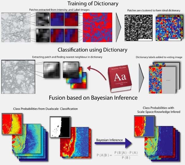
Linking Different Spatial Scales For Retrieval Of Sea Ice Conditions From SAR Images
 Linking Different Spatial Scales For Retrieval Of Sea Ice Conditions From SAR Images Matt Arkett 2, Wolfgang Dierking 1, Jakob Griebel 1, Thomas Hollands 1, Stefanie Linow 1, Eero Rinne 3, Markku Similä
Observations of Arctic snow and sea ice thickness from satellite and airborne surveys. Nathan Kurtz NASA Goddard Space Flight Center
 Observations of Arctic snow and sea ice thickness from satellite and airborne surveys Nathan Kurtz NASA Goddard Space Flight Center Decline in Arctic sea ice thickness and volume Kwok et al. (2009) Submarine
CryoSat: ESA s Ice Mission:
 CryoSat: ESA s Ice Mission: 6 years in operations: status and achievements T. Parrinello CryoSat Mission Manager M. Drinkwater Mission Scientist CryoSat March 2016 sea-ice thickness CryoSat: A bit of history
Evaluation of the sea ice forecast at DMI
 DMI Evaluation of the sea ice forecast at DMI Till A. S. Rasmussen 1 Kristine S. Madsen 1, Mads H. Ribergaard 1, Leif T.Pedersen 1, Jacob L Høyer 1, Gorm Dybkjær 1, Mads Bruun Poulsen 2 and Sofie Abildgaard
We greatly appreciate the thoughtful comments from the reviewers. According to the reviewer s comments, we revised the original manuscript.
 Response to the reviews of TC-2018-108 The potential of sea ice leads as a predictor for seasonal Arctic sea ice extent prediction by Yuanyuan Zhang, Xiao Cheng, Jiping Liu, and Fengming Hui We greatly
NSIDC Metrics Report. Lisa Booker February 9, 2012
 NSIDC Metrics Report Lisa Booker February 9, 2012 ACSI Scores 2011 ACSI survey summary Sent to 5458 users; increased number of users contacted NSIDC response rate was 10%, up 1% from last year. NSIDC Customer
ICE DRIFT IN THE FRAM STRAIT FROM ENVISAT ASAR DATA
 ICE DRIFT IN THE FRAM STRAIT FROM ENVISAT ASAR DATA Stein Sandven (1), Kjell Kloster (1), and Knut F. Dagestad (1) (1) Nansen Environmental and Remote Sensing Center (NERSC), Thormøhlensgte 47, N-5006
Ocean & Sea Ice SAF. Validation of ice products January September Version 1.0. September 2004
 Ocean & Sea Ice SAF Validation of ice products January 2002 - September 2004 Version 1.0 September 2004 Keld Q. Hansen, Morten Lind, Søren Andersen 1 INTRODUCTION... 3 2 PRODUCTS VALIDATION METHODS...
National Satellite Data Centre and Finnish Sentinel Collaborative Ground Segment. Jyri Heilimo Finnish Meteorological Instute
 National Satellite Data Centre and Finnish Sentinel Collaborative Ground Segment Jyri Heilimo Finnish Meteorological Instute Sodankylä National Satellite Data Centre National satellite data centre providing
Sinéad Louise Farrell1,2,3 Thomas Newman1,2,, Alek Petty 1,2, Jackie Richter-Menge4, Dave McAdoo1,2, Larry Connor2
 Sinéad Louise Farrell1,2,3 Thomas Newman1,2,, Alek Petty 1,2, Jackie Richter-Menge4, Dave McAdoo1,2, Larry Connor2 1 Earth System Science Interdisciplinary Center, University of Maryland, USA 2 NOAA Laboratory
Some NOAA Products that Address PSTG Satellite Observing Requirements. Jeff Key NOAA/NESDIS Madison, Wisconsin USA
 Some NOAA Products that Address PSTG Satellite Observing Requirements Jeff Key NOAA/NESDIS Madison, Wisconsin USA WMO Polar Space Task Group, 4 th meeting, Greenbelt, 30 September 2014 Relevant Missions
Observing Snow: Conventional Measurements, Satellite and Airborne Remote Sensing. Chris Derksen Climate Research Division, ECCC
 Observing Snow: Conventional Measurements, Satellite and Airborne Remote Sensing Chris Derksen Climate Research Division, ECCC Outline Three Snow Lectures: 1. Why you should care about snow 2. How we measure
ESA s Earth Observation Programmes
 ESA s Earth Observation Programmes 2015 DRAGON Symposium Interlaken, 23 June 2015 Maurice Borgeaud Head of the Department Science, Applications, and Future Technologies ESA Earth Observation Programmes
Status DLR (TerraSAR X / TanDEM X)
") SAR Coordination Working Meeting 5 Status DLR (TerraSAR X / TanDEM X) Dana Floricioiu, Achim Roth Imaging Requirements for TerraSAR X & TanDEM X Missions Ice Sheets: TSX supports Greenland outlet glaciers,
SAR Coordination Working Meeting 5 Status DLR (TerraSAR X / TanDEM X) Dana Floricioiu, Achim Roth Imaging Requirements for TerraSAR X & TanDEM X Missions Ice Sheets: TSX supports Greenland outlet glaciers,
Modeling of the sea ice and the ocean in the Nares Strait
 Danish Meteorological Institute Modeling of the sea ice and the ocean in the Nares Strait Till Andreas Soya Rasmussen 1 Eigil Kaas 2 Nicolai Kliem 1 1/ Danish Meteorological Institute 2/ University of
Validation of sea ice concentration in the myocean Arctic Monitoring and Forecasting Centre 1
 Note No. 12/2010 oceanography, remote sensing Oslo, August 9, 2010 Validation of sea ice concentration in the myocean Arctic Monitoring and Forecasting Centre 1 Arne Melsom 1 This document contains hyperlinks
Sea Ice Observations: Where Would We Be Without the Arctic Observing Network? Jackie Richter-Menge ERDC-CRREL
 Sea Ice Observations: Where Would We Be Without the Arctic Observing Network? Jackie Richter-Menge ERDC-CRREL Sea Ice Observations: Where Would We Be Without the Arctic Observing Network? Jackie Richter-Menge
Merged sea-ice thickness product from complementary L-band and altimetry information
 Merged sea-ice thickness product from complementary L-band and altimetry information Contributors AWI Team Stefan Hendricks Robert Ricker Stephan Paul University Hamburg Team Lars Kaleschke Xiangshan Tian-Kunze
A New Global Ice Analysis System
 A New Global Ice Analysis System Seminar CMC, Dorval Alain Caya and Mark Buehner Meteorological Research Division Manon Lajoie Prediction Development Branch Tom Carrieres and Lynn Pogson Marine and Ice
Opportunities for advanced Remote Sensing; an outsider s perspective
 Opportunities for advanced Remote Sensing; an outsider s perspective Ramon Hanssen Delft University of Technology 1 Starting questions Can we do more with the data we are already acquire? What s in stock
Polar Weather Prediction
 Polar Weather Prediction David H. Bromwich Session V YOPP Modelling Component Tuesday 14 July 2015 A special thanks to the following contributors: Kevin W. Manning, Jordan G. Powers, Keith M. Hines, Dan
OSI SAF Sea Ice Products
 OSI SAF Sea Ice Products Steinar Eastwood, Matilde Jensen, Thomas Lavergne, Gorm Dybkjær, Signe Aaboe, Rasmus Tonboe, Atle Sørensen, Jacob Høyer, Lars-Anders Breivik, RolfHelge Pfeiffer, Mari Anne Killie
Distribution and Thickness of Different Sea Ice Types and Extreme Ice Features in the Beaufort Sea: 2012 Field Report
 Distribution and Thickness of Different Sea Ice Types and Extreme Ice Features in the Beaufort Sea: 2012 Field Report July 2012 NCR#5859681 - v1 DISTRIBUTION AND THICKNESS OF DIFFERENT SEA ICE TYPES AND
OSI SAF Sea Ice products
 OSI SAF Sea Ice products Lars-Anders Brevik, Gorm Dybkjær, Steinar Eastwood, Øystein Godøy, Mari Anne Killie, Thomas Lavergne, Rasmus Tonboe, Signe Aaboe Norwegian Meteorological Institute Danish Meteorological
GLOBAL SATELLITE OBSERVATION REQUIREMENTS FOR FLOATING ICE
 GLOBAL SATELLITE OBSERVATION REQUIREMENTS FOR FLOATING ICE FOCUSING ON SYNTHETIC APERTURE RADAR MARCH 2014 JOHN C. FALKINGHAM Contact: John.Falkingham@rogers.com (Contract report for Environment Canada:
Assimilation of Snow and Ice Data (Incomplete list)
") Assimilation of Snow and Ice Data (Incomplete list) Snow/ice Sea ice motion (sat): experimental, climate model Sea ice extent (sat): operational, U.S. Navy PIPs model; Canada; others? Sea ice concentration
Assimilation of Snow and Ice Data (Incomplete list) Snow/ice Sea ice motion (sat): experimental, climate model Sea ice extent (sat): operational, U.S. Navy PIPs model; Canada; others? Sea ice concentration
Product Validation Report Polar Ocean
 Product Validation Report Polar Ocean Lars Stenseng PVR, Version 1.0 July 24, 2014 Product Validation Report - Polar Ocean Lars Stenseng National Space Institute PVR, Version 1.0, Kgs. Lyngby, July 24,
Wave processes in Arctic Seas, observed from TerraSAR-X
 DISTRIBUTION STATEMENT A. Approved for public release; distribution is unlimited. Wave processes in Arctic Seas, observed from TerraSAR-X Susanne Lehner DLR German Air and Space Research Center Earth Observation
ESA Status Report. ET-SAT-11, WMO, Geneva, CH, 4 April Prepared by Earth Observation Programmes Directorate
 ESA Status Report ET-SAT-11, WMO, Geneva, CH, 4 April 2017 Prepared by Earth Observation Programmes Directorate Presented by Ivan Petiteville, ESA, Earth Observation Programmes Issue/Revision: 0.0 Reference:
National / Naval Ice Center (NIC) Operations Brief This brief is UNCLASSIFIED
 Operations Brief This brief is UNCLASSIFIED") National / Naval Ice Center (NIC) Operations Brief This brief is UNCLASSIFIED Christopher Szorc, Senior Ice Analyst/Forecaster USCG USN NOAA Outline NIC s mission is to provide timely, accurate and relevant
National / Naval Ice Center (NIC) Operations Brief This brief is UNCLASSIFIED Christopher Szorc, Senior Ice Analyst/Forecaster USCG USN NOAA Outline NIC s mission is to provide timely, accurate and relevant
DLR s TerraSAR-X contributes to international fleet of radar satellites to map the Arctic and Antarctica
 DLR s TerraSAR-X contributes to international fleet of radar satellites to map the Arctic and Antarctica The polar regions play an important role in the Earth system. The snow and ice covered ocean and
K&C Phase 4 Status report. Ice Sheet Monitoring using ALOS-2. University of California, Irvine 2 JPL
 K&C Phase 4 Status report Ice Sheet Monitoring using ALOS-2 Bernd Scheuchl 1, Jeremie Mouginot 1, Eric Rignot 1,2 1 University of California, Irvine 2 JPL Science Team meeting #24 Tokyo, Japan, January
The Polar Ice Sheets Monitoring Project A Coordinated Response from Space Agencies
 The Polar Ice Sheets Monitoring Project A Coordinated Response from Space Agencies Yves Crevier / Members of the PSTG SAR Coordination WG Canadian Space Agency CEOS SIT-28 Meeting Hampton, Virginia, USA
Global SWE Mapping by Combining Passive and Active Microwave Data: The GlobSnow Approach and CoReH 2 O
 Global SWE Mapping by Combining Passive and Active Microwave Data: The GlobSnow Approach and CoReH 2 O April 28, 2010 J. Pulliainen, J. Lemmetyinen, A. Kontu, M. Takala, K. Luojus, K. Rautiainen, A.N.
Operational ice charting in mid-latitudes using Near-Real-Time SAR imagery
 Operational ice charting in mid-latitudes using Near-Real-Time SAR imagery Sergey Vernyayev Ice Engineer ICEMAN.KZ Carles Debart Project Manager Energy, Environment and Security Yevgeniy Kadranov Ice charting
QUALITY INFORMATION DOCUMENT For OSI TAC Sea Ice products , -002, -003, -004, -006, -007, -009, -010, -011, -012
 QUALITY INFORMATION DOCUMENT For OSI TAC Sea Ice products 011-001, -002, -003, -004, -006, -007, -009, -010, -011, -012 Issue: 2.5 Contributors: Steinar Eastwood (MET Norway), Juha Karvonen (FMI), Frode
Sea ice as a key climate indicator in the Arctic
 Sea ice as a key climate indicator in the Arctic Leif Toudal Pedersen, DMI Natalia Ivanova, NERSC Eero Rinne, FMI Roberto Saldo, DTU Georg Heygster, U-Bremen Rasmus Tonboe, DMI Thomas Lavergne, Met Norway
Investigating Coastal Polynya Thin Sea Ice State in the Laptev Sea Using TerraSAR-X Dual-Pol Stripmap Data
 Investigating Coastal Polynya Thin Sea Ice State in the Laptev Sea Using TerraSAR-X Dual-Pol Stripmap Data Thomas Busche (1), Irena Hajnsek (1), Thomas Krumpen (2), Lasse Rabenstein (2), Jens Hoelemann
Update on Coupled Air-Sea-Ice Modelling
 Update on Coupled Air-Sea-Ice Modelling H. Ritchie 1,4, G. Smith 1, J.-M. Belanger 1, J-F Lemieux 1, C. Beaudoin 1, P. Pellerin 1, M. Buehner 1, A. Caya 1, L. Fillion 1, F. Roy 2, F. Dupont 2, M. Faucher
Ice & Snow Session. Chairs: J. Mouginot & N. Gourmelen
 Ice & Snow Session Chairs: J. Mouginot & N. Gourmelen Session 12 talks and 10 posters Antarctic ice motion, ground-line detection and monitoring, dynamics ice-fluctuations in Antarctica and Greenland,
Group on Earth Observations (GEO) Cold Regions Work Plan Item WA-01-C3
 Cold Regions Work Plan Item WA-01-C3") EC Panel of Experts on Polar Observations, Research and Services Group on Earth Observations (GEO) Cold Regions Work Plan Item WA-01-C3 Barbara J. Ryan Secretariat Director Lanzhou, China 13 March 2013
EC Panel of Experts on Polar Observations, Research and Services Group on Earth Observations (GEO) Cold Regions Work Plan Item WA-01-C3 Barbara J. Ryan Secretariat Director Lanzhou, China 13 March 2013
Julia Figa-Saldaña & Klaus Scipal
 Julia Figa-Saldaña & Klaus Scipal julia.figa@eumetsat.int klaus.scipal@esa.int Meeting, Outline MetOp/EPS status MetOp/EPS Second Generation status 2016 scatterometer conference Other European ocean programme
Remote sensing of snow at SYKE Sari Metsämäki
 Remote sensing of snow at SYKE 2011-01-21 Sari Metsämäki Activities in different projects Snow extent product in ESA DUE-project GlobSnow Long term datasets (15-30 years) on Snow Extent (SE) and Snow Water
Could Instrumentation Drift Account for Arctic Sea Ice Decline?
 Could Instrumentation Drift Account for Arctic Sea Ice Decline? Jonathan J. Drake 3/31/2012 One of the key datasets used as evidence of anthropogenic global warming is the apparent decline in Arctic sea
Canadian Space Agency Update. STG 3 ESRIN, Frascati May 5-6, 2008 Yves Crevier
 Canadian Space Agency Update STG 3 ESRIN, Frascati May 5-6, 2008 Yves Crevier Role of CSA in IPY Ensure the use of Space Technologies in IPY Science initiatives Guarantee fluid and continued availability
C o p e r n i c u s L a n d M o n i t o r i n g S e r v i c e
 C o p e r n i c u s L a n d M o n i t o r i n g S e r v i c e Integration into existing Snow and Ice Services and draft product specifications Annett BARTSCH b.geos Copernicus High Resolution Snow and
Using Remote-sensed Sea Ice Thickness, Extent and Speed Observations to Optimise a Sea Ice Model
 Using Remote-sensed Sea Ice Thickness, Extent and Speed Observations to Optimise a Sea Ice Model Paul Miller, Seymour Laxon, Daniel Feltham, Douglas Cresswell Centre for Polar Observation and Modelling
Sea Ice Model for Marginal Ice Zone
 Sea Ice Model for Marginal Ice Zone Max D. Coon Northwest Research Associates, Inc. 14508 N.E. 20 th Street Bellevue, WA 98007-3713 Phone: (425) 644-9660 ext. 332 Fax: (425) 644-8422 E-mail: max@nwra.com
Remote Sensing of SWE in Canada
 Remote Sensing of SWE in Canada Anne Walker Climate Research Division, Environment Canada Polar Snowfall Hydrology Mission Workshop, June 26-28, 2007 Satellite Remote Sensing Snow Cover Optical -- Snow
Mass balance of sea ice in both hemispheres Airborne validation and the AWI CryoSat-2 sea ice data product
 Mass balance of sea ice in both hemispheres Airborne validation and the AWI CryoSat-2 sea ice data product Stefan Hendricks Robert Ricker Veit Helm Sandra Schwegmann Christian Haas Andreas Herber Airborne
Dual-Frequency Ku- Band Radar Mission Concept for Snow Mass
 Dual-Frequency Ku- Band Radar Mission Concept for Snow Mass Chris Derksen Environment and Climate Change Canada Study Team: Climate Research Division/Meteorological Research Division, ECCC Canadian Space
Regional Sea Ice Outlook for Greenland Sea and Barents Sea - based on data until the end of May 2013
 Regional Sea Ice Outlook for Greenland Sea and Barents Sea - based on data until the end of May 2013 Sebastian Gerland 1*, Max König 1, Angelika H.H. Renner 1, Gunnar Spreen 1, Nick Hughes 2, and Olga
Evaluating the Discrete Element Method as a Tool for Predicting the Seasonal Evolution of the MIZ
 DISTRIBUTION STATEMENT A. Approved for public release; distribution is unlimited. Evaluating the Discrete Element Method as a Tool for Predicting the Seasonal Evolution of the MIZ Arnold J. Song Cold Regions
Canadian Ice Service
 Canadian Ice Service Key Points and Details concerning the 2009 Arctic Minimum Summer Sea Ice Extent October 1 st, 2009 http://ice-glaces.ec.gc.ca 1 Key Points of Interest Arctic-wide The Arctic-wide minimum
Arctic Regional Ocean Observing System Arctic ROOS Report from 2012
 Arctic Regional Ocean Observing System Arctic ROOS Report from 2012 By Stein Sandven Nansen Environmental and Remote Sensing Center (www.arctic-roos.org) Focus in 2012 1. Arctic Marine Forecasting Center
EWGLAM/SRNWP National presentation from DMI
 EWGLAM/SRNWP 2013 National presentation from DMI Development of operational Harmonie at DMI Since Jan 2013 DMI updated HARMONIE-Denmark suite to CY37h1 with a 3h-RUC cycling and 57h forecast, 8 times a
Monitoring of Arctic Conditions from a Virtual Constellation of Synthetic Aperture Radar Satellites
 DISTRIBUTION STATEMENT A. Approved for public release; distribution is unlimited. Monitoring of Arctic Conditions from a Virtual Constellation of Synthetic Aperture Radar Satellites Hans C. Graber RSMAS
Snow Cover Applications: Major Gaps in Current EO Measurement Capabilities
 Snow Cover Applications: Major Gaps in Current EO Measurement Capabilities Thomas NAGLER ENVEO Environmental Earth Observation IT GmbH INNSBRUCK, AUSTRIA Polar and Snow Cover Applications User Requirements
The GMES/MyOcean Marine Service and its applications
 The GMES/MyOcean Marine Service and its applications P.Y. Le Traon (Ifremer) P. Bahurel (Mercator Ocean) First BreTel Workshop May 31st, 2012 - St Malo Outline The GMES Marine Service and MyOcean What
Better ice information onboard ships ECDIS S-411
 Better ice information onboard ships ECDIS S411 DeMarine User Workshop Dr. Jürgen Holfort Head of German ice service at the Bundesamt für Seeschifffahrt und Hydrographie Vicechair of the JCOMM Expert team
Polar. Thematic Exploitation Platform. Andrew Fleming, BAS/Polar View ESRIN, 14 th October 2015
 Polar Thematic Exploitation Platform Andrew Fleming, BAS/Polar View ESRIN, 14 th October 2015 Why a Polar TEP? Polar regions play an important role in regulating and driving the global climate & experiencing
Polar Portal Season Report 2016
 Polar Portal Season Report 2016 Less ice both on land and at sea This year s report is the fourth since the Polar Portal was launched, and as an introduction, we have chosen to take a look at the trends
Recent Data Assimilation Activities at Environment Canada
 Recent Data Assimilation Activities at Environment Canada Major upgrade to global and regional deterministic prediction systems (now in parallel run) Sea ice data assimilation Mark Buehner Data Assimilation
Souris River Basin Spring Runoff Outlook As of March 1, 2019
 Souris River Basin Spring Runoff Outlook As of March 1, 2019 Prepared by: Flow Forecasting & Operations Planning Water Security Agency Basin Conditions Summer rainfall in 2018 over the Saskatchewan portion
Ocean and Sea Ice TAC
 Ocean and Sea Ice TAC A CMEMS Element provided by the WITS Consortium (Wind, Ice and Temperature at the Sea Surface) Bruce Hackett, on behalf of the WITS team Presented at CMEMS User Workshop, Brussels,
Observed State of the Global Climate
 WMO Observed State of the Global Climate Jerry Lengoasa WMO June 2013 WMO Observations of Changes of the physical state of the climate ESSENTIAL CLIMATE VARIABLES OCEANIC ATMOSPHERIC TERRESTRIAL Surface
ECCC. Environment and Climate Change Canada. Organization contact. Paul Pestieau.
 ECCC Environment and Climate Change Canada http://www.ec.gc.ca Organization contact Paul Pestieau paul.pestieau@canada.ca Other contact 613-990-6855 Areas of contribution User-aspects and verification
SAR Coordination Working Group
 SAR Coordination Working Group Update for 2015 and Plans for 2016-18 The Polar Space Task Group (PSTG) was established under the auspices of the World Meteorological Organization. The PSTG provides coordination
Geoscience Australia Report on Cal/Val Activities
 Medhavy Thankappan Geoscience Australia Agency Report I Berlin May 6-8, 2015 Outline 1. Calibration / validation at Geoscience Australia Corner reflector infrastructure for SAR calibration (for information)
Optimizing Observations of Sea Ice Thickness and Snow Depth in the Arctic
 DISTRIBUTION STATEMENT A. Approved for public release; distribution is unlimited. Optimizing Observations of Sea Ice Thickness and Snow Depth in the Arctic Jacqueline A. Richter-Menge CRREL, 72 Lyme Road,
HANS ISLAND / TARTUPALUK A year of meteorological measurements
 HANS ISLAND / TARTUPALUK A year of meteorological measurements J.P. Wilkinson, P. Gudmandsen, S. Hanson, R. Saldo, R.M. Samelson, D. Barber, H. Melling, D. Mercer + many more Where is it? http://upload.wikimedia.org/wikipedia/commons/f/f8/nares_strait_border_(kennedy_channel).png
ALOS-2 Basic Observation Scenario (First Edition) January 10, 2014 JAXA/ALOS-2 Project
 January 10, 2014 JAXA/ALOS-2 Project") ALOS-2 Basic Observation Scenario (First Edition) January 10, 2014 JAXA/ALOS-2 Project 1 1.First edition 2.Purpose and Background 3.Approach of the Basic Observation Scenario 4.Basic Observation
ALOS-2 Basic Observation Scenario (First Edition) January 10, 2014 JAXA/ALOS-2 Project 1 1.First edition 2.Purpose and Background 3.Approach of the Basic Observation Scenario 4.Basic Observation
C-BAND MULTIPLE POLARIZATION SAR FOR ICE MONITORING WHAT CAN IT DO FOR THE CANADIAN ICE SERVICE
 C-BAND MULTIPLE POLARIZATION SAR FOR ICE MONITORING WHAT CAN IT DO FOR THE CANADIAN ICE SERVICE Matt Arkett, Dean Flett, and Roger De Abreu Canadian Ice Service, Meteorological Service of Canada, Environment
The impact of combined assimilation of altimeters data and wave spectra from S-1A and 1B in the operational model MFWAM
 The impact of combined assimilation of altimeters data and wave spectra from S-1A and 1B in the operational model MFWAM Lotfi Aouf and Alice Dalphinet Météo-France, Département Marine et Oceanographie
Recent Improvements in the U.S. Navy s Ice Modeling Efforts Using CryoSat-2 Ice Thickness for Model Initialization
 Recent Improvements in the U.S. Navy s Ice Modeling Efforts Using CryoSat-2 Ice Thickness for Model Initialization Richard Allard 1, David Hebert 1, Pamela Posey 1, Alan Wallcraft 1, Li Li 2, William Johnston
Arctic Weather Every 10 Minutes: Design & Operation of ABI for PCW
 Arctic Weather Every 10 Minutes: Design and Operation of ABI for PCW Dr. Paul C. Griffith and Sue Wirth 31st Space Symposium, Technical Track, Colorado Springs, Colorado This document is not subject to
EONav Satellite data in support of maritime route optimization
 EONav Satellite data in support of maritime route optimization Leif Eriksson Department of Space, Earth and Environment Chalmers University of Technology Outline Why is maritime navigation support needed?
Soil frost from microwave data. Kimmo Rautiainen, Jouni Pulliainen, Juha Lemmetyinen, Jaakko Ikonen, Mika Aurela
 Soil frost from microwave data Kimmo Rautiainen, Jouni Pulliainen, Juha Lemmetyinen, Jaakko Ikonen, Mika Aurela Why landscape freeze/thaw? Latitudinal variation in mean correlations (r) between annual
NESDIS Global Automated Satellite Snow Product: Current Status and Planned Upgrades Peter Romanov
 NESDIS Global Automated Satellite Snow Product: Current Status and Planned Upgrades Peter Romanov NOAA-CREST, City University of New York (CUNY) Center for Satellite Applications and Research (STAR), NOAA/NESDIS
Ice Observations on the Churchill River using Satellite Imagery
 CGU HS Committee on River Ice Processes and the Environment 15 th Workshop on River Ice St. John s, Newfoundland and Labrador, June 15-17, 2009 Ice Observations on the Churchill River using Satellite Imagery
Sentinel and ESA Third-Party Mission data access and processing tools
 Sentinel and ESA Third-Party Mission data access and processing tools Magdalena Fitrzyk RSAC c/o ESA ESRIN 11/09/2018 Content Copernicus Sentinel missions Copernicus Open Access Hub: Sentinels Data Access
From L1 to L2 for sea ice concentration. Rasmus Tonboe Danish Meteorological Institute EUMETSAT OSISAF
 From L1 to L2 for sea ice concentration Rasmus Tonboe Danish Meteorological Institute EUMETSAT OSISAF Sea-ice concentration = sea-ice surface fraction Water Ice e.g. Kern et al. 2016, The Cryosphere
Polar Portal Season Report 2018
 Polar Portal Season Report 2018 Unusual weather resulted in an atypical melting season in the Arctic The 2017-18 season in the Arctic has once again been extraordinary. A cold summer with high levels of
Today s Lecture: Land, biosphere, cryosphere (All that stuff we don t have equations for... )
") Today s Lecture: Land, biosphere, cryosphere (All that stuff we don t have equations for... ) 4 Land, biosphere, cryosphere 1. Introduction 2. Atmosphere 3. Ocean 4. Land, biosphere, cryosphere 4.1 Land
Today s Lecture: Land, biosphere, cryosphere (All that stuff we don t have equations for... ) 4 Land, biosphere, cryosphere 1. Introduction 2. Atmosphere 3. Ocean 4. Land, biosphere, cryosphere 4.1 Land