ESA GlobSnow - project overview
|
|
|
- Lucas Sparks
- 6 years ago
- Views:
Transcription
1 ESA GlobSnow - project overview GCW 1 st Implementation meeting Geneve, 23 Nov K. Luojus & J. Pulliainen (FMI) + R. Solberg (NR) Finnish Meteorological Institute
2 ESA GlobSnow ESA-GlobSnow project: Production of novel hemispherical snow extent (SE) and snow water equivalent (SWE) climate data records. Generation of long time-series employing FMI supercomputing facilities at Helsinki (daily, weekly and monthly maps of SE and SWE for northern hemisphere) Near-real-time GlobSnow processing system and data archives located in Sodankylä. Consortium members: Finnish Meteorological Institute (FMI) with ENVEO IT GmbH (Austria), GAMMA Remote Sensing (Switzerland), Norwegian Computing Center, Finnish Environment Institute (SYKE), and Environment Canada (EC). Details and products available at Finnish Meteorological Institute
 - 25 km resolution (EASE-grid) - Time-series for 1979-2011 Passive microwave radiometer data combined with ground-based synoptic snow observations - Variational")
3 30 year-long CDR time-series on snow conditions of Northern Hemisphere (ESA-GlobSnow SWE) First time reliable daily spatial information on SWE (snow cover): - Snow Water Equivalent (SWE) - Snow Extent and melt (+grain size) - 25 km resolution (EASE-grid) - Time-series for Passive microwave radiometer data combined with ground-based synoptic snow observations - Variational data-assimilation Available at open data archive ( Demonstration of NRT processing started on October 2010 Greenland, glaciers & mountains masked out
4 SWE algorithm selection & validation SWE estimates from 5 algorithms evaluated for Eurasia ( ) FMI Assimilation algorithm (Pulliainen 2006) EC SWE suite (Goodison, Walker, Goita, Derksen et al ) Chang et al (original channel difference algorithm) SPD-algorithm (Asbacher 1989) Armstrong and Brodzik 2001-algorithm (Improved channel difference) SWE algorithm evaluation for 09/1994 and 12/1997 (SSM/I data) Evaluations for North America and Finland were carried out in addition to the analyses for Eurasia Finnish Meteorological Institute
 transects measuring snow depth There were 450 path stations with data for 1994-1997 Finnish Meteorological Institute 1.12.")
5 Validation data INTAS SSCONE data INTAS SSCONE data (from the former USSR and Russia) There are 1294 snow path stations with data from the USSR Manual (0.5 2km) transects measuring snow depth There were 450 path stations with data for Finnish Meteorological Institute
6 Overall performance for SWE algorithms Eurasia 09/ /1997 Reference data: independent snow transects Name RMSE bias Corr.coeff Unbiased RMSE Samples FMI algorithm used for GlobSnow) 43.2 mm -3.1 mm mm EC algorithm 67.6 mm mm mm Chang et al (asc node) Chang et al (desc node) 71.6 mm 70.7 mm -8.4 mm 1.6 mm mm 70.8 mm SPD algorithm (asc node) SPD algorithm (desc node) 67.1 mm 63.9 mm mm -3.1 mm mm 63.9 mm Armstrong et al (asc node) Armstrong et al (desc node) 72.3 mm 73.7 mm mm mm mm 59.9 mm Finnish Meteorological Institute

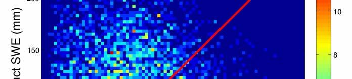

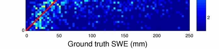
7 SWE retrieval (data assimilation vs. channel diff.) Density scatterplot (assimilated vs. satellite only SWE) Ground truth data is INTAS SCCONE SWE transect data
 SMMR F 8 SSM/I F 11 SSM/I F 13 SSM/I F 17 SSM/I SMMR F 8 SSM/I F 11 SSM/I F 13 SSM/I F 17 SSM/I SWE<150")
8 Consistency of SWE retrieval RMS error and retrieval bias calculated independently for each year Reference data: snow transects from Russia (INTAS-SCCONE) SMMR F 8 SSM/I F 11 SSM/I F 13 SSM/I F 17 SSM/I SMMR F 8 SSM/I F 11 SSM/I F 13 SSM/I F 17 SSM/I SWE<150 mm
 fractional snow cover (FSC) algorithm; - 15 years SE data record has been produced using optical imagery from ATSR-2 (1995-) and AATSR (2002-) on a hemispherical")
9 GlobSnow SE Dataset SE retrieval using ERS-2 ATSR-2 and Envisat AATSR data - Finnish Environment Institute s SCAmod algorithm. - Norwegian Linear Reflectance (NLR) fractional snow cover (FSC) algorithm; - 15 years SE data record has been produced using optical imagery from ATSR-2 (1995-) and AATSR (2002-) on a hemispherical scale. yellow clouds green bare ground white snow cover Finnish Meteorological Institute


10 Daily, weekly and monthly products Optical data ~ 1km spatial resolution 310 March April March April March April Finnish Meteorological Institute


11 Examples of monthly products, 2010


12 Examples of monthly products, 2010 April 2003 May 2003 June 2003


13 Example: Trend analysis using SWE product Apr


14 Snow clearance date Example for year 2008 Time series of 30 years processed and distributed along the SWE product Apr
15


16 Frost tube measurements in Finland Operated by Finnish environmental institute Default configuration: Three frost tubes in three different locations: Open area, Forest and Bog site. Manually recorder three times per month (usually 6 th, 16 th and 26 th ). During freezing and thawing 5 times. Almost 40 manually recorded frost tube stations. In Sodankylä, automatic temperature profile measurements installed next to frost tubes for comparison.

17 Frost tube locations Typically three tubes in three main land classes: forest, bog, open Forest Bog Open


18 Two winter time-series: ELBARA-II and frost/snow Inc. angle: 50 Snow Snow Frost Frost
19 Hemispherical trend of snow extent (PMW ~25km) Finnish Meteorological Institute
20 Hemispherical trend of snow mass Finnish Meteorological Institute
21 GlobSnow - Summary Production of novel global snow extent (SE) and snow water equivalent (SWE) climate data records (15 and 30 years of snow cover information) - coarse resolution (25km) SWE and SE for medium resolution (1km) SE for Additionally, near-real-time GlobSnow processing demonstration is ongoing with open data access (started on October 2010) Additional information and all GlobSnow products available at Finnish Meteorological Institute
22 Any Questions? (GlobSnow-handouts available ) Finnish Meteorological Institute
Global SWE Mapping by Combining Passive and Active Microwave Data: The GlobSnow Approach and CoReH 2 O
 Global SWE Mapping by Combining Passive and Active Microwave Data: The GlobSnow Approach and CoReH 2 O April 28, 2010 J. Pulliainen, J. Lemmetyinen, A. Kontu, M. Takala, K. Luojus, K. Rautiainen, A.N.
Examples on Sentinel data applications in Finland, possibilities, plans and how NSDC will be utilized - Snow
 Examples on Sentinel data applications in Finland, possibilities, plans and how NSDC will be utilized - Snow Kari Luojus, Jouni Pulliainen, Jyri Heilimo, Matias Takala, Juha Lemmetyinen, Ali Arslan, Timo
Assimilation of GlobSnow Data in HIRLAM. Suleiman Mostamandy Kalle Eerola Laura Rontu Katya Kourzeneva
 Assimilation of GlobSnow Data in HIRLAM Suleiman Mostamandy Kalle Eerola Laura Rontu Katya Kourzeneva 10/03/2011 Contents Introduction Snow from satellites Globsnow Other satellites The current study Experiment
ASSESSMENT OF NORTHERN HEMISPHERE SWE DATASETS IN THE ESA SNOWPEX INITIATIVE
 ASSESSMENT OF NORTHERN HEMISPHERE SWE DATASETS IN THE ESA SNOWPEX INITIATIVE Kari Luojus 1), Jouni Pulliainen 1), Matias Takala 1), Juha Lemmetyinen 1), Chris Derksen 2), Lawrence Mudryk 2), Michael Kern
Remote sensing of snow at SYKE Sari Metsämäki
 Remote sensing of snow at SYKE 2011-01-21 Sari Metsämäki Activities in different projects Snow extent product in ESA DUE-project GlobSnow Long term datasets (15-30 years) on Snow Extent (SE) and Snow Water
Environmental observations over Arctic areas potential for monitoring the spread of infectious diseases
 Environmental observations over Arctic areas potential for monitoring the spread of infectious diseases Ali Nadir Arslan ali.nadir.arslan@fmi.fi ARCTIC RESEARCH DEAPARTMENT / FMI ARKTIKO Seminar, Helsinki,
Global Snow Monitoring for Climate Research. Final Report (FR) EUROPEAN SPACE AGENCY STUDY CONTRACT REPORT ESRIN Contract 21703/08/I-EC
 EUROPEAN SPACE AGENCY STUDY CONTRACT REPORT ESRIN Contract 21703/08/I-EC") Global Snow Monitoring for Climate Research Final Report (FR) EUROPEAN SPACE AGENCY STUDY CONTRACT REPORT ESRIN Contract DELIVERABLE 3.5 PREPARED BY Kari LUOJUS, Jouni PULLIAINEN, Matias TAKALA, Juha LEMMETYINEN
Global Snow Monitoring for Climate Research Final Report (FR) EUROPEAN SPACE AGENCY STUDY CONTRACT REPORT ESRIN Contract DELIVERABLE 3.5 PREPARED BY Kari LUOJUS, Jouni PULLIAINEN, Matias TAKALA, Juha LEMMETYINEN
ADVANCEMENTS IN SNOW MONITORING
 Polar Space Task Group ADVANCEMENTS IN SNOW MONITORING Thomas Nagler, ENVEO IT GmbH, Innsbruck, Austria Outline Towards a pan-european Multi-sensor Snow Product SnowPEx Summary Upcoming activities SEOM
Copernicus Global Land Service
 Copernicus Global Land Service Cryosphere Products Kari Luojus on behalf the consortium Follow us on: Copernicus EU CopernicusEU www.copernicus.eu Copernicus Services Land Marine Atmosphere Emergency Security
Intercomparison of Snow Extent Products from Earth Observation Data
 Intercomparison of Snow Extent Products from Earth Observation Data, Elisabeth Ripper, Gabriele Bippus, Helmut Rott FMI Richard Fernandes Kari Luojus Sari Metsämäki Dorothy Hall David Robinson Bojan Bojkov
Soil frost from microwave data. Kimmo Rautiainen, Jouni Pulliainen, Juha Lemmetyinen, Jaakko Ikonen, Mika Aurela
 Soil frost from microwave data Kimmo Rautiainen, Jouni Pulliainen, Juha Lemmetyinen, Jaakko Ikonen, Mika Aurela Why landscape freeze/thaw? Latitudinal variation in mean correlations (r) between annual
The indicator can be used for awareness raising, evaluation of occurred droughts, forecasting future drought risks and management purposes.
 INDICATOR FACT SHEET SSPI: Standardized SnowPack Index Indicator definition The availability of water in rivers, lakes and ground is mainly related to precipitation. However, in the cold climate when precipitation
GlobSnow-2 Final Report
 Global Snow Monitoring for Climate Research GlobSnow-2 Final Report EUROPEAN SPACE AGENCY STUDY CONTRACT REPORT ESRIN Contract PREPARED BY KARI LUOJUS, JOUNI PULLIAINEN, MATIAS TAKALA, JUHA LEMMETYINEN,
FMI Arctic Space Centre. Jyri Heilimo Finnish Meteorological Institute
 FMI Arctic Space Centre Jyri Heilimo Finnish Meteorological Institute FMI - Arctic Space Center Studies of atmospheric phenomena and their interaction with biosphere and cryosphere in high latitudes Hydrology,
Assimilation of Globsnow data into HIRLAM. Mostamandy Suleiman Sodankyla August 2011
 Assimilation of Globsnow data into HIRLAM Mostamandy Suleiman Sodankyla August 2011 Motivation Small number of observations (especially in eastern Europe and Russia) 00 cm of snow problem Non-uniform in
Regional Activities and Perspectives on GCW: Relevant FMI Activities at Northern Finland and Suggestions for GCW Monitoring Site Requirements
 Regional Activities and Perspectives on GCW: Relevant FMI Activities at Northern Finland and Suggestions for GCW Monitoring Site Requirements Jouni Pulliainen 21 November 2011 Suggestions for GCW monitoring
Remote Sensing of Environment
 Remote Sensing of Environment 115 (2011) 3517 3529 Contents lists available at SciVerse ScienceDirect Remote Sensing of Environment journal homepage: www.elsevier.com/locate/rse Estimating northern hemisphere
Observing Snow: Conventional Measurements, Satellite and Airborne Remote Sensing. Chris Derksen Climate Research Division, ECCC
 Observing Snow: Conventional Measurements, Satellite and Airborne Remote Sensing Chris Derksen Climate Research Division, ECCC Outline Three Snow Lectures: 1. Why you should care about snow 2. How we measure
Algorithm Theoretical Basis Document SWE-algorithm
 Global Snow Monitoring for Climate Research Algorithm Theoretical Basis Document SWE-algorithm EUROPEAN SPACE AGENCY STUDY CONTRACT REPORT ESRIN Contract DELIVERABLE 06 PREPARED BY KARI LUOJUS, JOUNI PULLIAINEN,
SIMULATION OF SPACEBORNE MICROWAVE RADIOMETER MEASUREMENTS OF SNOW COVER FROM IN-SITU DATA AND EMISSION MODELS
 SIMULATION OF SPACEBORNE MICROWAVE RADIOMETER MEASUREMENTS OF SNOW COVER FROM IN-SITU DATA AND EMISSION MODELS Anna Kontu 1 and Jouni Pulliainen 1 1. Finnish Meteorological Institute, Arctic Research,
LIFE12 ENV/FIN/ st summary report of snow data 30/09/2014
 LIFE Project Number 1st summary report of snow data Reporting Date 30/09/2014 LIFE+ PROJECT NAME or Acronym Climate change indicators and vulnerability of boreal zone applying innovative observation and
Validation of passive microwave snow algorithms
 Remote Sensing and Hydrology 2000 (Proceedings of a symposium held at Santa Fe, New Mexico, USA, April 2000). IAHS Publ. no. 267, 2001. 87 Validation of passive microwave snow algorithms RICHARD L. ARMSTRONG
H-SAF Snow products and their use in applications. Matias Takala
 H-SAF Snow products and their use in applications Matias Takala Matias.takala@fmi.fi H-SAF snow products H-SAF: EUMETSAT funded satellite application facility (SAF) for Support to Operational Hydrology
Determination of the snow melting intensity in nowadays climate conditions by example of the Neman river basin
 Determination of the snow melting intensity in nowadays climate conditions by example of the Neman river basin Alexander Volchak, Dmitriy Kostiuk, Dmitriy Petrov, Nikolay Sheshko Brest State Technical
Remote Sensing of SWE in Canada
 Remote Sensing of SWE in Canada Anne Walker Climate Research Division, Environment Canada Polar Snowfall Hydrology Mission Workshop, June 26-28, 2007 Satellite Remote Sensing Snow Cover Optical -- Snow
Validation of satellite derived snow cover data records with surface networks and m ulti-dataset inter-comparisons
 Validation of satellite derived snow cover data records with surface networks and m ulti-dataset inter-comparisons Chris Derksen Climate Research Division Environment Canada Thanks to our data providers:
Climate Models and Snow: Projections and Predictions, Decades to Days
 Climate Models and Snow: Projections and Predictions, Decades to Days Outline Three Snow Lectures: 1. Why you should care about snow 2. How we measure snow 3. Snow and climate modeling The observational
The ESA SnowPex project and an introduction to the APVE workshops
 The ESA SnowPex project and an introduction to the APVE workshops Bojan R. Bojkov Head Sensor Performance, Products and Algorithms Directorate of Earth Observation Programmes European Space Agency ESA/ESRIN
C o p e r n i c u s L a n d M o n i t o r i n g S e r v i c e
 C o p e r n i c u s L a n d M o n i t o r i n g S e r v i c e Integration into existing Snow and Ice Services and draft product specifications Annett BARTSCH b.geos Copernicus High Resolution Snow and
Copernicus Land Monitoring Services
 Copernicus Land Monitoring Services TASK 3: CONTINUATION OF SNOW & ICE TASK D 3.2: Summary Report to Support EEA Date: June 2017 Version: 1.0 Prepared by: Marketa Jindrova (GISAT) Joan Bauzà Llinàs Alaitz
Snow Cover Applications: Major Gaps in Current EO Measurement Capabilities
 Snow Cover Applications: Major Gaps in Current EO Measurement Capabilities Thomas NAGLER ENVEO Environmental Earth Observation IT GmbH INNSBRUCK, AUSTRIA Polar and Snow Cover Applications User Requirements
The use of earth observation technology to improve the characterization of ice and snow
 The use of earth observation technology to improve the characterization of ice and snow Swedish Meteorological and Hydrological Institute (SMHI) Outline: EO and ice/snow CryoLand North Hydrology EO in
Advancements and validation of the global CryoClim snow cover extent product
 www.nr.no Advancements and validation of the global CryoClim snow cover extent product Rune Solberg1, Øystein Rudjord1, Arnt-Børre Salberg1 and Mari Anne Killie2 1) Norwegian Computing Center (NR), P.O.
LANDSAF SNOW COVER MAPPING USING MSG/SEVIRI DATA
 LANDSAF SNOW COVER MAPPING USING MSG/SEVIRI DATA Niilo Siljamo and Otto Hyvärinen Finnish Meteorological Institute, Erik Palménin aukio 1, P.O.Box 503, FI-00101 Helsinki, Finland Abstract Land Surface
Discritnination of a wet snow cover using passive tnicrowa ve satellite data
 Annals of Glaciology 17 1993 International Glaciological Society Discritnination of a wet snow cover using passive tnicrowa ve satellite data A. E. WALKER AND B. E. GOODISON Canadian Climate Centre, 4905
THE USE OF MERIS SPECTROMETER DATA IN SEASONAL SNOW MAPPING
 THE USE OF MERIS SPECTROMETER DATA IN SEASONAL SNOW MAPPING Miia Eskelinen, Sari Metsämäki The Finnish Environment Institute Geoinformatics and Land use division P.O.Box 140, FI 00251 Helsinki, Finland
Snow and Albedo as Essential Climate Variables
 Snow and Albedo as Essential Climate Variables Jason E. Box Geological Survey of Denmark and Greenland Copenhagen, Denmark current (alphabetical) national collaboration 1.Liège, Belgium 2.Copenhagen, Denmark
Artificial neural network-based techniques for the retrieval of SWE and snow depth from SSM/I data
 Remote Sensing of Environment 90 (2004) 76 85 www.elsevier.com/locate/rse Artificial neural network-based techniques for the retrieval of SWE and snow depth from SSM/I data M. Tedesco a, *, J. Pulliainen
/$ IEEE
 2996 IEEE TRANSACTIONS ON GEOSCIENCE AND REMOTE SENSING, VOL. 47, NO. 9, SEPTEMBER 2009 Detection of Snowmelt Using Spaceborne Microwave Radiometer Data in Eurasia From 1979 to 2007 Matias Takala, Jouni
Helsinki Testbed - a contribution to NASA's Global Precipitation Measurement (GPM) mission
 mission") Helsinki Testbed - a contribution to NASA's Global Precipitation Measurement (GPM) mission Ubicasting workshop, September 10, 2008 Jarkko Koskinen, Jarmo Koistinen, Jouni Pulliainen, Elena Saltikoff, David
Helsinki Testbed - a contribution to NASA's Global Precipitation Measurement (GPM) mission Ubicasting workshop, September 10, 2008 Jarkko Koskinen, Jarmo Koistinen, Jouni Pulliainen, Elena Saltikoff, David
VALIDATION RESULTS OF THE OPERATIONAL LSA-SAF SNOW COVER MAPPING
 VALIDATION RESULTS OF THE OPERATIONAL LSA-SAF SNOW COVER MAPPING Niilo Siljamo, Otto Hyvärinen Finnish Meteorological Institute, Erik Palménin aukio 1, P.O.Box 503, FI-00101 HELSINKI Abstract Hydrological
Permafrost: Earth Observation Applications: Introduction
 Polar Meeting 3 Permafrost: Earth Observation Applications: Introduction Mark Drinkwater CNES, Paris, 22 23 May, 2013 Remote Sensing of Permafrost which Remote Sensing products? applicability to Permafrost
Satellite-based Lake Surface Temperature (LST) Homa Kheyrollah Pour Claude Duguay
 Homa Kheyrollah Pour Claude Duguay") Satellite-based Lake Surface Temperature (LST) Homa Kheyrollah Pour Claude Duguay Lakes in NWP models Interaction of the atmosphere and underlying layer is the most important issue in climate modeling
Satellite-based Lake Surface Temperature (LST) Homa Kheyrollah Pour Claude Duguay Lakes in NWP models Interaction of the atmosphere and underlying layer is the most important issue in climate modeling
Snow maps based on satellite data
 Snow maps based on satellite data SNAPS Work Package 4: Final report on WP 4 Prepared by Eirik Malnes, Norut, Norway Kari Luojus, Jaakko Ikonen and Matias Takala, FMI, Finland Hrobjartur Thorsteinsson
Application of EO for Environmental Monitoring at the Finnish Environment Institute
 Application of EO for Environmental Monitoring at the Finnish Environment Institute Data Processing (CalFin) and Examples of Products Markus Törmä Finnish Environment Institute SYKE markus.torma@ymparisto.fi
Remote Sensing of Environment
 Remote Sensing of Environment 117 (2012) 236 248 Contents lists available at SciVerse ScienceDirect Remote Sensing of Environment journal homepage: www.elsevier.com/locate/rse Evaluation of passive microwave
Intercomparison and Evaluation Experiment
 The SnowPEx Satellite Satellite Snow Product Intercomparison Snow and Evaluation Experiment Product (6/2014 5/2016) Intercomparison and Evaluation Experiment Report to PSTG WG Meeting # 5 DLR, 5 Oct 2015
Studying snow cover in European Russia with the use of remote sensing methods
 40 Remote Sensing and GIS for Hydrology and Water Resources (IAHS Publ. 368, 2015) (Proceedings RSHS14 and ICGRHWE14, Guangzhou, China, August 2014). Studying snow cover in European Russia with the use
Bugs in JRA-55 snow depth analysis
 14 December 2015 Climate Prediction Division, Japan Meteorological Agency Bugs in JRA-55 snow depth analysis Bugs were recently found in the snow depth analysis (i.e., the snow depth data generation process)
Canadian Prairie Snow Cover Variability
 Canadian Prairie Snow Cover Variability Chris Derksen, Ross Brown, Murray MacKay, Anne Walker Climate Research Division Environment Canada Ongoing Activities: Snow Cover Variability and Links to Atmospheric
ESA snow monitoring initiatives
 ESA snow monitoring initiatives Bojan R. Bojkov Head, Sensor Performance, Products and Algorithms (SPPA) Directorate of Earth Observation Programmes ESA/ESRIN Why snow at ESA? Downstream services ESA instrument
Time-series analysis of passive-microwave-derived central North American snow water equivalent imagery
 Annals of Glaciology 34 2002 # International Glaciological Society Time-series analysis of passive-microwave-derived central North American snow water equivalent imagery C. Derksen, 1 A.Walker, 2 E. LeDrew,
Prof. Jouni Pulliainen
 Prof. Jouni Pulliainen Arctic and Space Finnish Meteorological Institute, Arctic Space Center Long arctic time series from the meteor. observatory in Sodankylä First thermo-/barometer based records in
SNOW COVER MAPPING USING METOP/AVHRR AND MSG/SEVIRI
 SNOW COVER MAPPING USING METOP/AVHRR AND MSG/SEVIRI Niilo Siljamo, Markku Suomalainen, Otto Hyvärinen Finnish Meteorological Institute, P.O.Box 503, FI-00101 Helsinki, Finland Abstract Weather and meteorological
H SAF SATELLITE APPLICATION FACILITY ON SUPPORT TO OPERATIONAL HYDROLOGY AND WATER MANAGEMENT EUMETSAT NETWORK OF SATELLITE APPLICATION FACILITIES
 H SAF SATELLITE APPLICATION FACILITY ON SUPPORT TO OPERATIONAL HYDROLOGY AND WATER MANAGEMENT EUMETSAT NETWORK OF SATELLITE APPLICATION FACILITIES H-SAF: SATELLITE PRODUCTS FOR OPERATIONAL HYDROLOGY H-SAF
Status and further development of CryoClim global Snow Cover Extent product
 www.nr.no Status and further development of CryoClim global Snow Cover Extent product Rune Solberg 1, Øystein Rudjord 1, Arnt-Børre Salberg 1 and Mari Anne Killie 2 1) Norwegian Computing Center (NR),
NOAA Snow Map Climate Data Record Generated at Rutgers
 NOAA Snow Map Climate Data Record Generated at Rutgers David A. Robinson Rutgers University Piscataway, NJ Snow Watch 2013 Downsview, Ontario January 29, 2013 December 2012 snow extent departures Motivation
The Satellite Snow Product Intercomparison and Evaluation Experiment Objectives, Status, Expected Results
 SnowPEx Satellite Snow Product Intercomparison and Evaluation Experiment (6/2014 5/2016) The Satellite Snow Product Intercomparison and Evaluation Experiment Objectives, Status, Expected Results Thomas
This is version v0.2 of this report issued together with the SIT and SIV data sets at the ICDC ESA-CCI- Projekt web page
 Report about Retrieval of sea-ice volume (SIV) from SICCI-2 sea-ice thickness (SIT) data and combined OSI-450 and SICCI-2 sea-ice concentration (SIC) data version v0.2, June 2018 by Stefan Kern, ICDC,
MSG/SEVIRI AND METOP/AVHRR SNOW EXTENT PRODUCTS IN H-SAF
 MSG/SEVIRI AND METOP/AVHRR SNOW EXTENT PRODUCTS IN H-SAF Niilo Siljamo, Otto Hyvärinen Finnish Meteorological Institute, Erik Palménin aukio 1, Helsinki, Finland Abstract Weather and meteorological processes
USE OF SATELLITE INFORMATION IN THE HUNGARIAN NOWCASTING SYSTEM
 USE OF SATELLITE INFORMATION IN THE HUNGARIAN NOWCASTING SYSTEM Mária Putsay, Zsófia Kocsis and Ildikó Szenyán Hungarian Meteorological Service, Kitaibel Pál u. 1, H-1024, Budapest, Hungary Abstract The
Durham Research Online
 Durham Research Online Deposited in DRO: 19 May 215 Version of attached le: Accepted Version Peer-review status of attached le: Peer-reviewed Citation for published item: Hancock, S. and Baxter, R. and
Climate Change and Water Cycle: Effect to Water Resources and their Utilization in Finland (CLIMWATER)
") Climate Change and Water Cycle: Effect to Water Resources and their Utilization in Finland (CLIMWATER) Final Seminar of the Ficca Programme 2.12.2014 J. Pulliainen (FMI), L. Backman, J. Kaurola, T. Olsson,
Climate Change and Water Cycle: Effect to Water Resources and their Utilization in Finland (CLIMWATER) Final Seminar of the Ficca Programme 2.12.2014 J. Pulliainen (FMI), L. Backman, J. Kaurola, T. Olsson,
NESDIS Global Automated Satellite Snow Product: Current Status and Recent Results Peter Romanov
 NESDIS Global Automated Satellite Snow Product: Current Status and Recent Results Peter Romanov NOAA-CREST, City University of New York (CUNY) Center for Satellite Applications and Research (STAR), NOAA/NESDIS
ARCTIC SEA ICE ALBEDO VARIABILITY AND TRENDS,
 ARCTIC SEA ICE ALBEDO VARIABILITY AND TRENDS, 1982-1998 Vesa Laine Finnish Meteorological Institute (FMI), Helsinki, Finland Abstract Whole-summer and monthly sea ice regional albedo averages, variations
NOVEL SNOW DEPTH RETRIEVAL METHOD USING TIME SERIES SSMI PASSIVE MICROWAVE IMAGERY
 NOVEL SNOW DEPTH RETRIEVAL METHOD USING TIME SERIES SSMI PASSIVE MICROWAVE IMAGERY Z. Nikraftar a, M. Hasanlou a,*, M. Esmaeilzadeh a a School of Surveying and Geospatial Engineering, College of Engineering,
Snow property extraction based on polarimetry and differential SAR interferometry
 Snow property extraction based on polarimetry and differential SAR interferometry S. Leinß, I. Hajnsek Earth Observation and Remote Sensing, Institute of Enviromental Science, ETH Zürich TerraSAR X and
III. Publication III. c 2004 Authors
 III Publication III J-P. Kärnä, J. Pulliainen, K. Luojus, N. Patrikainen, M. Hallikainen, S. Metsämäki, and M. Huttunen. 2004. Mapping of snow covered area using combined SAR and optical data. In: Proceedings
A. Windnagel M. Savoie NSIDC
 National Snow and Ice Data Center ADVANCING KNOWLEDGE OF EARTH'S FROZEN REGIONS Special Report #18 06 July 2016 A. Windnagel M. Savoie NSIDC W. Meier NASA GSFC i 2 Contents List of Figures... 4 List of
Evaluation and Assimilation of Remotely- Sensed Lake Surface Temperature in the HIRLAM Weather Forecasting System
 Evaluation and Assimilation of Remotely- Sensed Lake Surface Temperature in the HIRLAM Weather Forecasting System H. Kheyrollah Pour 1, C.R. Duguay 1, L. Rontu 2 with contributions from Kalle Eerola 2,
A New Global Ice Analysis System
 A New Global Ice Analysis System Seminar CMC, Dorval Alain Caya and Mark Buehner Meteorological Research Division Manon Lajoie Prediction Development Branch Tom Carrieres and Lynn Pogson Marine and Ice
Modelling and Data Assimilation Needs for improving the representation of Cold Processes at ECMWF
 Modelling and Data Assimilation Needs for improving the representation of Cold Processes at ECMWF presented by Gianpaolo Balsamo with contributions from Patricia de Rosnay, Richard Forbes, Anton Beljaars,
Description of Snow Depth Retrieval Algorithm for ADEOS II AMSR
 1. Introduction Description of Snow Depth Retrieval Algorithm for ADEOS II AMSR Dr. Alfred Chang and Dr. Richard Kelly NASA/GSFC The development of a snow depth retrieval algorithm for ADEOS II AMSR has
National Satellite Data Centre and Finnish Sentinel Collaborative Ground Segment. Jyri Heilimo Finnish Meteorological Instute
 National Satellite Data Centre and Finnish Sentinel Collaborative Ground Segment Jyri Heilimo Finnish Meteorological Instute Sodankylä National Satellite Data Centre National satellite data centre providing
SEASONAL SNOW COVER EXTENT FROM MICROWAVE REMOTE SENSING DATA: COMPARISON WITH EXISTING GROUND AND SATELLITE BASED MEASUREMENTS
 EARSeL eproceedings 4, 2/2005 215 SEASONAL SNOW COVER EXTENT FROM MICROWAVE REMOTE SENSING DATA: COMPARISON WITH EXISTING GROUND AND SATELLITE BASED MEASUREMENTS Arnaud Mialon 1,2, Michel Fily 1 and Alain
LIFE12 ENV/FIN/ First Data Document 31/05/2015
 LIFE Project Number First Data Document Action B.3 Summary report of albedo data Reporting Date 31/05/2015 LIFE+ PROJECT NAME or Acronym Climate change indicators and vulnerability of boreal zone applying
Spatial and Temporal Variability of Snow Depth Derived from Passive Microwave Remote Sensing Data in Kazakhstan
 NO.6 MASHTAYEVA Shamshagul, DAI Liyun, CHE Tao, et al. 1033 Spatial and Temporal Variability of Snow Depth Derived from Passive Microwave Remote Sensing Data in Kazakhstan MASHTAYEVA Shamshagul 1, DAI
ESM-Snow model intercomparison
 Grand Challenge Cryosphere in a Changing Climate ESM-Snow model intercomparison C. Derksen, G. Krinner, R. Essery, M. Flanner, S. Hagemann, H. Rott Motivation Rapid snow extent changes in NH Climate change
ECMWF snow data assimilation: Use of snow cover products and In situ snow depth data for NWP
 snow data assimilation: Use of snow cover products and In situ snow depth data for NWP Patricia de Rosnay Thanks to: Ioannis Mallas, Gianpaolo Balsamo, Philippe Lopez, Anne Fouilloux, Mohamed Dahoui, Lars
PROGRESS IN ADDRESSING SCIENCE GOALS FOR SNOW MONITORING BY MEANS OF SAR
 Polar Space Task Group PROGRESS IN ADDRESSING SCIENCE GOALS FOR SNOW MONITORING BY MEANS OF SAR Thomas Nagler, Helmut Rott, ENVEO IT GmbH, Innsbruck, Austria SNOW: Observational Requirements and SAR Products
Estimation of snow surface temperature for NW Himalayan regions using passive microwave satellite data
 Indian Journal of Radio & Space Physics Vol 42, February 2013, pp 27-33 Estimation of snow surface temperature for NW Himalayan regions using passive microwave satellite data K K Singh 1,$,*, V D Mishra
Claude Duguay University of Waterloo
 Claude Duguay University of Waterloo with contributions from K. Kang and H. Kheyrollah Pour 2nd Annual EarthTemp Network Meeting Surface temperature in data-sparse and extreme regions 12-14 June 2013 Copenhagen,
Remote Sensing of Environment
 Remote Sensing of Environment 156 (2015) 96 108 Contents lists available at ScienceDirect Remote Sensing of Environment journal homepage: www.elsevier.com/locate/rse Introduction to GlobSnow Snow Extent
Evaluation of snow cover and snow depth on the Qinghai Tibetan Plateau derived from passive microwave remote sensing
 https://doi.org/10.5194/tc-11-1933-2017 Author(s) 2017. This work is distributed under the Creative Commons Attribution 3.0 License. Evaluation of snow cover and snow depth on the Qinghai Tibetan Plateau
A Comparison of A MSR-E/Aqua Snow Products with in situ Observations and M O DIS Snow Cover Products in the Mackenzie River Basin, Canada
 Remote Sensing 2010, 2, 2313-2322; doi:10.3390/rs2102313 Letter OPE N A C C ESS Remote Sensing ISSN 2072-4292 www.mdpi.com/journal/remotesensing A Comparison of A MSR-E/Aqua Snow Products with in situ
ASimultaneousRadiometricand Gravimetric Framework
 Towards Multisensor Snow Assimilation: ASimultaneousRadiometricand Gravimetric Framework Assistant Professor, University of Maryland Department of Civil and Environmental Engineering September 8 th, 2014
Detection of external influence on Northern Hemispheric snow cover
 Detection of external influence on Northern Hemispheric snow cover Tianshu Ma 1, Xuebin Zhang 1,2 Helene Massam 1, Francis Zwiers 3 Georges Monette 1, David Robinson 4 1 Dept. of Mathematics and Statistics,
Assimilating AMSU-A over Sea Ice in HIRLAM 3D-Var
 Abstract Assimilating AMSU-A over Sea Ice in HIRLAM 3D-Var Vibeke W. Thyness 1, Leif Toudal Pedersen 2, Harald Schyberg 1, Frank T. Tveter 1 1 Norwegian Meteorological Institute (met.no) Box 43 Blindern,
Validation of 2-meters temperature forecast at cold observed conditions by different NWP models
 Validation of 2-meters temperature forecast at cold observed conditions by different NWP models Evgeny Atlaskin Finnish Meteorological Institute / Russian State Hydrometeorological University OUTLINE Background
RETRIEVAL OF SOIL MOISTURE OVER SOUTH AMERICA DERIVED FROM MICROWAVE OBSERVATIONS
 2nd Workshop on Remote Sensing and Modeling of Surface Properties 9-11 June 2009, Toulouse, France Météo France Centre International de Conférences RETRIEVAL OF SOIL MOISTURE OVER SOUTH AMERICA DERIVED
Lake ice cover and surface water temperature II: Satellite remote sensing
 Lake ice cover and surface water temperature II: Satellite remote sensing Claude Duguay University of Waterloo (Canada) Earth Observation Summer School ESA-ESRIN, Frascati, Italy (4-14 August 2014) Lecture
SNOW DEPTH AND SURFACE CONDITIONS OF AUSTFONNA ICE CAP (SVALBARD) USING FIELD OBSERVATIONS AND SATELLITE ALTIMETRY
 USING FIELD OBSERVATIONS AND SATELLITE ALTIMETRY") SNOW DEPTH AND SURFACE CONDITIONS OF AUSTFONNA ICE CAP (SVALBARD) USING FIELD OBSERVATIONS AND SATELLITE ALTIMETRY Alexei Kouraev (1,2), Benoît Legrésy (1), Frédérique Rémy (1), Andrea Taurisano (3,4),
SNOW DEPTH AND SURFACE CONDITIONS OF AUSTFONNA ICE CAP (SVALBARD) USING FIELD OBSERVATIONS AND SATELLITE ALTIMETRY Alexei Kouraev (1,2), Benoît Legrésy (1), Frédérique Rémy (1), Andrea Taurisano (3,4),
NESDIS Global Automated Satellite Snow Product: Current Status and Planned Upgrades Peter Romanov
 NESDIS Global Automated Satellite Snow Product: Current Status and Planned Upgrades Peter Romanov NOAA-CREST, City University of New York (CUNY) Center for Satellite Applications and Research (STAR), NOAA/NESDIS
SWAMPS. Surface WAter Microwave Product Series Version 2.0
 SWAMPS Surface WAter Microwave Product Series Version 2.0 This dataset is accessible through the Inundated Wetlands Earth System Data Record Project URL: http://wetlands.jpl.nasa.gov Point of Contact:
Presentation of met.no s experience and expertise related to high resolution reanalysis
 Presentation of met.no s experience and expertise related to high resolution reanalysis Oyvind Saetra, Ole Einar Tveito, Harald Schyberg and Lars Anders Breivik Norwegian Meteorological Institute Daily
NSIDC/Univ. of Colorado Sea Ice Motion and Age Products
 NSIDC/Univ. of Colorado Sea Ice Motion and Age Products Polar Pathfinder Daily 25 km EASE-Grid Sea Ice Motion Vectors, http://nsidc.org/data/nsidc-0116.html Passive microwave, AVHRR, and buoy motions Individual
Central Asia Regional Flash Flood Guidance System 4-6 October Hydrologic Research Center A Nonprofit, Public-Benefit Corporation
 http://www.hrcwater.org Central Asia Regional Flash Flood Guidance System 4-6 October 2016 Hydrologic Research Center A Nonprofit, Public-Benefit Corporation FFGS Snow Components Snow Accumulation and
Improvement of objective analysis of lake surface state in HIRLAM using satellite observations
 HIRLAM ASM 2013 & ALADIN 23 rd Workshop Reykjavik, Iceland 15-19 April, 2013 Improvement of objective analysis of lake surface state in HIRLAM using satellite observations H. Kheyrollah Pour, C.R. Duguay
The University of Texas at Austin, Jackson School of Geosciences, Austin, Texas 2. The National Center for Atmospheric Research, Boulder, Colorado 3
 Assimilation of MODIS Snow Cover and GRACE Terrestrial Water Storage Data through DART/CLM4 Yong-Fei Zhang 1, Zong-Liang Yang 1, Tim J. Hoar 2, Hua Su 1, Jeffrey L. Anderson 2, Ally M. Toure 3,4, and Matthew
APPLICATION OF SATELLITE MICROWAVE IMAGES IN ESTIMATING SNOW WATER EQUIVALENT 1
 JOURNAL OF THE AMERICAN WATER RESOURCES ASSOCIATION Vol. 44, No. 6 AMERICAN WATER RESOURCES ASSOCIATION December 2008 APPLICATION OF SATELLITE MICROWAVE IMAGES IN ESTIMATING SNOW WATER EQUIVALENT 1 Amir