Remote sensing of snow at SYKE Sari Metsämäki
|
|
|
- Cecil Bridges
- 6 years ago
- Views:
Transcription
1 Remote sensing of snow at SYKE Sari Metsämäki

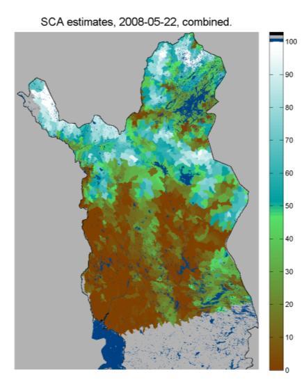
 Outside mapping area 0% Water 50% Not mapped in product time frame Too low solar angle for snow retrieval Missing")
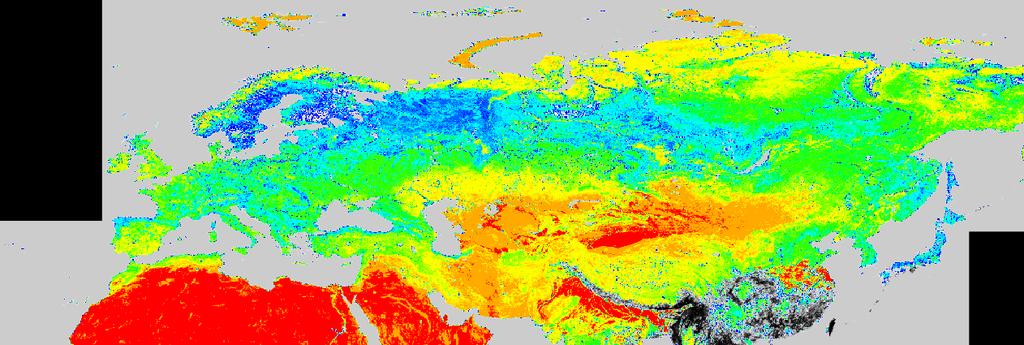
2 Activities in different projects Snow extent product in ESA DUE-project GlobSnow Long term datasets (15-30 years) on Snow Extent (SE) and Snow Water Equivalent (SWE) for climate research purposes. SYKE s SCAmod method for fractional snow cover mapping implemented for Northern hemisphere Based on Envisat/AATSR and ERS-2/ATSR-2 Operational production of fundamantal climate record on snow, implemented and operated by the Finnish Metorological Institute (FMI) Outside mapping area 0% Water 50% Not mapped in product time frame Too low solar angle for snow retrieval Missing or invalid satellite data 100% Fractional snow cover Steps of 1% in product, steps of 10% in colour legend Cloud Snow retrieval algorithm breakdown No snow retrieval algorithm applicable


3 Activities in different projects ESA PolarView Operational production of Fractional snow maps over Baltic Sea Area Based on SCAmod applied to Terra/MODIS


4 Polar View Baltic region snow service processing flow Pre-prosessing Product calculation Data delivery Receiving station End products Internet Data fetching Automatic fetching & archieving Pre-prosessing Unpacking Calibration Athmospheric correction Geocoding Archieving SCA A SCA model Calculation Archiving Cloud masking Automatic Visual verification Hydrological model SCA for 3rd order drainage basins

5 PolarView service at SYKE 2011

6 Polar View Portal


7 Fractional Snow Cover maps by SCAmod Envisat/AATSR Terra/MODIS SYKE SCAmod-method: examples of Fractional snow cover maps on April 2, 2004


8 Fractional Snow Cover maps by SCAmod Terra/MODIS NOAA/AVHRR Apr29, 2006 Apr19, 2008 SYKE SCAmod-method: example of Fractional snow cover maps
 1 (1 tˆ snow 2 i ) ground forest ground (SCA) snow ground forest tˆ SCA observed")

9 ( SCA) ( 1 t ) * 2 2 Reflectance model forest t SCA * ( 1 SCA) * snow ground SCA i 1 tˆ 2 i ( SCA) 1 (1 tˆ snow 2 i ) ground forest ground (SCA) snow ground forest tˆ SCA observed reflectance from unit area reflectance for wet snow reflectance for snow-free ground reflectance for forest canopy forest canopy transmissivity for unit area fraction of snow covered area

10 Northern Hemisphere transmissivity map for SCAmod

11 SYKE snow course network A snow course is a 2 to 4 km long trail through various terrains typical of the locality. Each course measured once a month Measurements on snow depth along the trail at locations, with information on land cover type. For density, the snow is weighed at 8 points along the snow course. The fraction of snow-free ground (patchiness) is visually estimated at each snow depth measurement point.

12 Land cover types used in snow course measurement recording 1 open area 2 forest opening 3 forest, pine dominating 4 forest, spruce dominating 5 forest, deciduous dominating 6 open bog
 snow depth Daily measurements over several decades Snow e-code Indication 9 dry snow full cover 7 wet snow full cover 6 snow cover more")
13 Weather station observations by FMI The Finnish Meteorological Institute regularly produces several kinds of observations nearly from 500 locations around the country. The SE related measured parameters: state of ground (e-code) snow depth Daily measurements over several decades Snow e-code Indication 9 dry snow full cover 7 wet snow full cover 6 snow cover more than 50% but less than 100% 5 snow cover less than 50% but more than 0% 4 Open areas snow free, snow exists in forests 3 0% snow cover

14 SCA from RADARSAT-1 Since spring images during spring Augments the optical method Results assimilated to WSFS Method developed at TKK
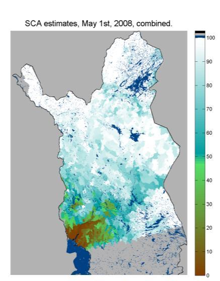
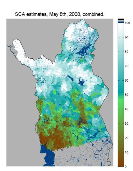
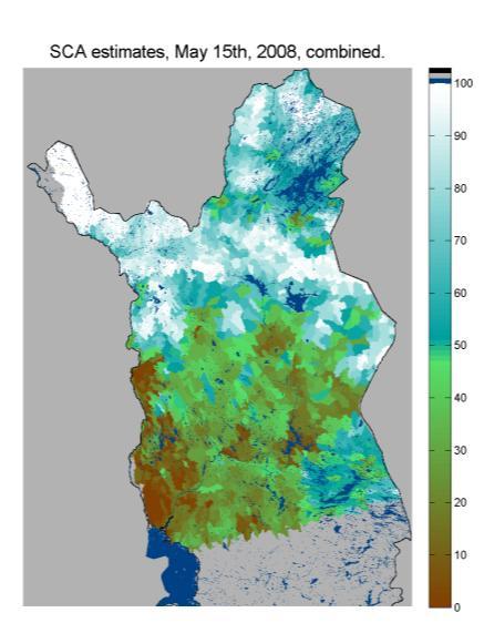
15 SCA from RADARSAT-1 Spring 2008

16 SWE from microwave radiometer and weather station measurements Assimilation method Data Microwave radiometer data (AMSR-E) Weather station snow depth measurements Microwave emission model Pulliainen, J. Mapping of snow water equivalent and snow depth in boreal and sub-arctic zones by assimilating space-borne microwave radiometer data and ground-based observations, Remote Sens. Environ., vol 101, pp , 2006.


17 Satellite SWE estimation process background info SWE estimate Weather station


18 Interpolated snow depth Snow depth using Ordinary Kriging Interpolation error

19 SWE maps from spring 2009

20 Snow Covered Area on Lake Ice (MODIS-Terra) Snow Covered Area on Lake ice from 8 th, 18 th and 27 th May 2010, lake Inari March 2011 Product Portfolio

21 Snow Covered Area on Lake Ice (MODIS-Terra) Snow Covered Area on Lake ice from March 09, April 12 and May 05, lake Päijänne March 2011 Product Portfolio

22 Ice cover in Lake Laatokka
ESA GlobSnow - project overview
 ESA GlobSnow - project overview GCW 1 st Implementation meeting Geneve, 23 Nov. 2011 K. Luojus & J. Pulliainen (FMI) + R. Solberg (NR) Finnish Meteorological Institute 1.12.2011 1 ESA GlobSnow ESA-GlobSnow
Examples on Sentinel data applications in Finland, possibilities, plans and how NSDC will be utilized - Snow
 Examples on Sentinel data applications in Finland, possibilities, plans and how NSDC will be utilized - Snow Kari Luojus, Jouni Pulliainen, Jyri Heilimo, Matias Takala, Juha Lemmetyinen, Ali Arslan, Timo
III. Publication III. c 2004 Authors
 III Publication III J-P. Kärnä, J. Pulliainen, K. Luojus, N. Patrikainen, M. Hallikainen, S. Metsämäki, and M. Huttunen. 2004. Mapping of snow covered area using combined SAR and optical data. In: Proceedings
Global SWE Mapping by Combining Passive and Active Microwave Data: The GlobSnow Approach and CoReH 2 O
 Global SWE Mapping by Combining Passive and Active Microwave Data: The GlobSnow Approach and CoReH 2 O April 28, 2010 J. Pulliainen, J. Lemmetyinen, A. Kontu, M. Takala, K. Luojus, K. Rautiainen, A.N.
THE USE OF MERIS SPECTROMETER DATA IN SEASONAL SNOW MAPPING
 THE USE OF MERIS SPECTROMETER DATA IN SEASONAL SNOW MAPPING Miia Eskelinen, Sari Metsämäki The Finnish Environment Institute Geoinformatics and Land use division P.O.Box 140, FI 00251 Helsinki, Finland
Copernicus Global Land Service
 Copernicus Global Land Service Cryosphere Products Kari Luojus on behalf the consortium Follow us on: Copernicus EU CopernicusEU www.copernicus.eu Copernicus Services Land Marine Atmosphere Emergency Security
LIFE12 ENV/FIN/ st summary report of snow data 30/09/2014
 LIFE Project Number 1st summary report of snow data Reporting Date 30/09/2014 LIFE+ PROJECT NAME or Acronym Climate change indicators and vulnerability of boreal zone applying innovative observation and
Assimilation of GlobSnow Data in HIRLAM. Suleiman Mostamandy Kalle Eerola Laura Rontu Katya Kourzeneva
 Assimilation of GlobSnow Data in HIRLAM Suleiman Mostamandy Kalle Eerola Laura Rontu Katya Kourzeneva 10/03/2011 Contents Introduction Snow from satellites Globsnow Other satellites The current study Experiment
Helsinki Testbed - a contribution to NASA's Global Precipitation Measurement (GPM) mission
 mission") Helsinki Testbed - a contribution to NASA's Global Precipitation Measurement (GPM) mission Ubicasting workshop, September 10, 2008 Jarkko Koskinen, Jarmo Koistinen, Jouni Pulliainen, Elena Saltikoff, David
Helsinki Testbed - a contribution to NASA's Global Precipitation Measurement (GPM) mission Ubicasting workshop, September 10, 2008 Jarkko Koskinen, Jarmo Koistinen, Jouni Pulliainen, Elena Saltikoff, David
FMI Arctic Space Centre. Jyri Heilimo Finnish Meteorological Institute
 FMI Arctic Space Centre Jyri Heilimo Finnish Meteorological Institute FMI - Arctic Space Center Studies of atmospheric phenomena and their interaction with biosphere and cryosphere in high latitudes Hydrology,
Determination of the snow melting intensity in nowadays climate conditions by example of the Neman river basin
 Determination of the snow melting intensity in nowadays climate conditions by example of the Neman river basin Alexander Volchak, Dmitriy Kostiuk, Dmitriy Petrov, Nikolay Sheshko Brest State Technical
ASSESSMENT OF NORTHERN HEMISPHERE SWE DATASETS IN THE ESA SNOWPEX INITIATIVE
 ASSESSMENT OF NORTHERN HEMISPHERE SWE DATASETS IN THE ESA SNOWPEX INITIATIVE Kari Luojus 1), Jouni Pulliainen 1), Matias Takala 1), Juha Lemmetyinen 1), Chris Derksen 2), Lawrence Mudryk 2), Michael Kern
H-SAF Snow products and their use in applications. Matias Takala
 H-SAF Snow products and their use in applications Matias Takala Matias.takala@fmi.fi H-SAF snow products H-SAF: EUMETSAT funded satellite application facility (SAF) for Support to Operational Hydrology
The indicator can be used for awareness raising, evaluation of occurred droughts, forecasting future drought risks and management purposes.
 INDICATOR FACT SHEET SSPI: Standardized SnowPack Index Indicator definition The availability of water in rivers, lakes and ground is mainly related to precipitation. However, in the cold climate when precipitation
Remote Sensing of SWE in Canada
 Remote Sensing of SWE in Canada Anne Walker Climate Research Division, Environment Canada Polar Snowfall Hydrology Mission Workshop, June 26-28, 2007 Satellite Remote Sensing Snow Cover Optical -- Snow
SIMULATION OF SPACEBORNE MICROWAVE RADIOMETER MEASUREMENTS OF SNOW COVER FROM IN-SITU DATA AND EMISSION MODELS
 SIMULATION OF SPACEBORNE MICROWAVE RADIOMETER MEASUREMENTS OF SNOW COVER FROM IN-SITU DATA AND EMISSION MODELS Anna Kontu 1 and Jouni Pulliainen 1 1. Finnish Meteorological Institute, Arctic Research,
Intercomparison of Snow Extent Products from Earth Observation Data
 Intercomparison of Snow Extent Products from Earth Observation Data, Elisabeth Ripper, Gabriele Bippus, Helmut Rott FMI Richard Fernandes Kari Luojus Sari Metsämäki Dorothy Hall David Robinson Bojan Bojkov
ADVANCEMENTS IN SNOW MONITORING
 Polar Space Task Group ADVANCEMENTS IN SNOW MONITORING Thomas Nagler, ENVEO IT GmbH, Innsbruck, Austria Outline Towards a pan-european Multi-sensor Snow Product SnowPEx Summary Upcoming activities SEOM
Environmental observations over Arctic areas potential for monitoring the spread of infectious diseases
 Environmental observations over Arctic areas potential for monitoring the spread of infectious diseases Ali Nadir Arslan ali.nadir.arslan@fmi.fi ARCTIC RESEARCH DEAPARTMENT / FMI ARKTIKO Seminar, Helsinki,
Validation of satellite derived snow cover data records with surface networks and m ulti-dataset inter-comparisons
 Validation of satellite derived snow cover data records with surface networks and m ulti-dataset inter-comparisons Chris Derksen Climate Research Division Environment Canada Thanks to our data providers:
Observing Snow: Conventional Measurements, Satellite and Airborne Remote Sensing. Chris Derksen Climate Research Division, ECCC
 Observing Snow: Conventional Measurements, Satellite and Airborne Remote Sensing Chris Derksen Climate Research Division, ECCC Outline Three Snow Lectures: 1. Why you should care about snow 2. How we measure
Satellite-based Lake Surface Temperature (LST) Homa Kheyrollah Pour Claude Duguay
 Homa Kheyrollah Pour Claude Duguay") Satellite-based Lake Surface Temperature (LST) Homa Kheyrollah Pour Claude Duguay Lakes in NWP models Interaction of the atmosphere and underlying layer is the most important issue in climate modeling
Satellite-based Lake Surface Temperature (LST) Homa Kheyrollah Pour Claude Duguay Lakes in NWP models Interaction of the atmosphere and underlying layer is the most important issue in climate modeling
Copernicus Land Monitoring Services
 Copernicus Land Monitoring Services TASK 3: CONTINUATION OF SNOW & ICE TASK D 3.2: Summary Report to Support EEA Date: June 2017 Version: 1.0 Prepared by: Marketa Jindrova (GISAT) Joan Bauzà Llinàs Alaitz
The use of earth observation technology to improve the characterization of ice and snow
 The use of earth observation technology to improve the characterization of ice and snow Swedish Meteorological and Hydrological Institute (SMHI) Outline: EO and ice/snow CryoLand North Hydrology EO in
Climate Models and Snow: Projections and Predictions, Decades to Days
 Climate Models and Snow: Projections and Predictions, Decades to Days Outline Three Snow Lectures: 1. Why you should care about snow 2. How we measure snow 3. Snow and climate modeling The observational
Application of EO for Environmental Monitoring at the Finnish Environment Institute
 Application of EO for Environmental Monitoring at the Finnish Environment Institute Data Processing (CalFin) and Examples of Products Markus Törmä Finnish Environment Institute SYKE markus.torma@ymparisto.fi
USE OF SATELLITE INFORMATION IN THE HUNGARIAN NOWCASTING SYSTEM
 USE OF SATELLITE INFORMATION IN THE HUNGARIAN NOWCASTING SYSTEM Mária Putsay, Zsófia Kocsis and Ildikó Szenyán Hungarian Meteorological Service, Kitaibel Pál u. 1, H-1024, Budapest, Hungary Abstract The
Soil frost from microwave data. Kimmo Rautiainen, Jouni Pulliainen, Juha Lemmetyinen, Jaakko Ikonen, Mika Aurela
 Soil frost from microwave data Kimmo Rautiainen, Jouni Pulliainen, Juha Lemmetyinen, Jaakko Ikonen, Mika Aurela Why landscape freeze/thaw? Latitudinal variation in mean correlations (r) between annual
Global Snow Monitoring for Climate Research. Final Report (FR) EUROPEAN SPACE AGENCY STUDY CONTRACT REPORT ESRIN Contract 21703/08/I-EC
 EUROPEAN SPACE AGENCY STUDY CONTRACT REPORT ESRIN Contract 21703/08/I-EC") Global Snow Monitoring for Climate Research Final Report (FR) EUROPEAN SPACE AGENCY STUDY CONTRACT REPORT ESRIN Contract DELIVERABLE 3.5 PREPARED BY Kari LUOJUS, Jouni PULLIAINEN, Matias TAKALA, Juha LEMMETYINEN
Global Snow Monitoring for Climate Research Final Report (FR) EUROPEAN SPACE AGENCY STUDY CONTRACT REPORT ESRIN Contract DELIVERABLE 3.5 PREPARED BY Kari LUOJUS, Jouni PULLIAINEN, Matias TAKALA, Juha LEMMETYINEN
Regional Activities and Perspectives on GCW: Relevant FMI Activities at Northern Finland and Suggestions for GCW Monitoring Site Requirements
 Regional Activities and Perspectives on GCW: Relevant FMI Activities at Northern Finland and Suggestions for GCW Monitoring Site Requirements Jouni Pulliainen 21 November 2011 Suggestions for GCW monitoring
Assimilation of Globsnow data into HIRLAM. Mostamandy Suleiman Sodankyla August 2011
 Assimilation of Globsnow data into HIRLAM Mostamandy Suleiman Sodankyla August 2011 Motivation Small number of observations (especially in eastern Europe and Russia) 00 cm of snow problem Non-uniform in
Data assimilation over lakes
 Data assimilation over lakes Ekaterina Kurzeneva 18-20 September 2012,Helsinki, FMI Contents Introduction Lake observations Lake data assimilation: overlook and methods Lake model FLake from DA point of
GlobSnow-2 Final Report
 Global Snow Monitoring for Climate Research GlobSnow-2 Final Report EUROPEAN SPACE AGENCY STUDY CONTRACT REPORT ESRIN Contract PREPARED BY KARI LUOJUS, JOUNI PULLIAINEN, MATIAS TAKALA, JUHA LEMMETYINEN,
Central Asia Regional Flash Flood Guidance System 4-6 October Hydrologic Research Center A Nonprofit, Public-Benefit Corporation
 http://www.hrcwater.org Central Asia Regional Flash Flood Guidance System 4-6 October 2016 Hydrologic Research Center A Nonprofit, Public-Benefit Corporation FFGS Snow Components Snow Accumulation and
Snow maps based on satellite data
 Snow maps based on satellite data SNAPS Work Package 4: Final report on WP 4 Prepared by Eirik Malnes, Norut, Norway Kari Luojus, Jaakko Ikonen and Matias Takala, FMI, Finland Hrobjartur Thorsteinsson
Pan-Arctic Land and Lake Surface Temperature from AATSR and MODIS: Products Development and Evaluation
 Pan-Arctic Land and Lake Surface Temperature from AATSR and MODIS: Products Development and Evaluation Homa Kheyrollah Pour Claude Duguay University of Waterloo 1 st Arctic Products Validation & Evolution
Snow Cover Applications: Major Gaps in Current EO Measurement Capabilities
 Snow Cover Applications: Major Gaps in Current EO Measurement Capabilities Thomas NAGLER ENVEO Environmental Earth Observation IT GmbH INNSBRUCK, AUSTRIA Polar and Snow Cover Applications User Requirements
Studying snow cover in European Russia with the use of remote sensing methods
 40 Remote Sensing and GIS for Hydrology and Water Resources (IAHS Publ. 368, 2015) (Proceedings RSHS14 and ICGRHWE14, Guangzhou, China, August 2014). Studying snow cover in European Russia with the use
National Satellite Data Centre and Finnish Sentinel Collaborative Ground Segment. Jyri Heilimo Finnish Meteorological Instute
 National Satellite Data Centre and Finnish Sentinel Collaborative Ground Segment Jyri Heilimo Finnish Meteorological Instute Sodankylä National Satellite Data Centre National satellite data centre providing
Climate Change and Water Cycle: Effect to Water Resources and their Utilization in Finland (CLIMWATER)
") Climate Change and Water Cycle: Effect to Water Resources and their Utilization in Finland (CLIMWATER) Final Seminar of the Ficca Programme 2.12.2014 J. Pulliainen (FMI), L. Backman, J. Kaurola, T. Olsson,
Climate Change and Water Cycle: Effect to Water Resources and their Utilization in Finland (CLIMWATER) Final Seminar of the Ficca Programme 2.12.2014 J. Pulliainen (FMI), L. Backman, J. Kaurola, T. Olsson,
CLIMATE CHANGE AND REGIONAL HYDROLOGY ACROSS THE NORTHEAST US: Evidence of Changes, Model Projections, and Remote Sensing Approaches
 CLIMATE CHANGE AND REGIONAL HYDROLOGY ACROSS THE NORTHEAST US: Evidence of Changes, Model Projections, and Remote Sensing Approaches Michael A. Rawlins Dept of Geosciences University of Massachusetts OUTLINE
Floating Ice: Progress in Addressing Science Goals
 Polar Floating Ice: Progress in Addressing Science Goals Stephen Howell 1, Leif Toudal Pedersen 2 and Roberto Saldo 3 1 Environment Canada, Climate Research Division, Toronto, Canada 2 Danish Meteorological
Dual-Frequency Ku- Band Radar Mission Concept for Snow Mass
 Dual-Frequency Ku- Band Radar Mission Concept for Snow Mass Chris Derksen Environment and Climate Change Canada Study Team: Climate Research Division/Meteorological Research Division, ECCC Canadian Space
Evaluation and Assimilation of Remotely- Sensed Lake Surface Temperature in the HIRLAM Weather Forecasting System
 Evaluation and Assimilation of Remotely- Sensed Lake Surface Temperature in the HIRLAM Weather Forecasting System H. Kheyrollah Pour 1, C.R. Duguay 1, L. Rontu 2 with contributions from Kalle Eerola 2,
Operational water balance model for Siilinjärvi mine
 Operational water balance model for Siilinjärvi mine Vesa Kolhinen, Tiia Vento, Juho Jakkila, Markus Huttunen, Marie Korppoo, Bertel Vehviläinen Finnish Environment Institute (SYKE) Freshwater Centre/Watershed
C o p e r n i c u s L a n d M o n i t o r i n g S e r v i c e
 C o p e r n i c u s L a n d M o n i t o r i n g S e r v i c e Integration into existing Snow and Ice Services and draft product specifications Annett BARTSCH b.geos Copernicus High Resolution Snow and
RETRIEVAL OF SOIL MOISTURE OVER SOUTH AMERICA DERIVED FROM MICROWAVE OBSERVATIONS
 2nd Workshop on Remote Sensing and Modeling of Surface Properties 9-11 June 2009, Toulouse, France Météo France Centre International de Conférences RETRIEVAL OF SOIL MOISTURE OVER SOUTH AMERICA DERIVED
Canadian Prairie Snow Cover Variability
 Canadian Prairie Snow Cover Variability Chris Derksen, Ross Brown, Murray MacKay, Anne Walker Climate Research Division Environment Canada Ongoing Activities: Snow Cover Variability and Links to Atmospheric
Meteorological Satellite Image Interpretations, Part III. Acknowledgement: Dr. S. Kidder at Colorado State Univ.
 Meteorological Satellite Image Interpretations, Part III Acknowledgement: Dr. S. Kidder at Colorado State Univ. Dates EAS417 Topics Jan 30 Introduction & Matlab tutorial Feb 1 Satellite orbits & navigation
Discritnination of a wet snow cover using passive tnicrowa ve satellite data
 Annals of Glaciology 17 1993 International Glaciological Society Discritnination of a wet snow cover using passive tnicrowa ve satellite data A. E. WALKER AND B. E. GOODISON Canadian Climate Centre, 4905
Merged sea-ice thickness product from complementary L-band and altimetry information
 Merged sea-ice thickness product from complementary L-band and altimetry information Contributors AWI Team Stefan Hendricks Robert Ricker Stephan Paul University Hamburg Team Lars Kaleschke Xiangshan Tian-Kunze
Ice Surface temperatures, status and utility. Jacob Høyer, Gorm Dybkjær, Rasmus Tonboe and Eva Howe Center for Ocean and Ice, DMI
 Ice Surface temperatures, status and utility Jacob Høyer, Gorm Dybkjær, Rasmus Tonboe and Eva Howe Center for Ocean and Ice, DMI Outline Motivation for IST data production IST from satellite Infrared Passive
Drought Monitoring with Hydrological Modelling
 st Joint EARS/JRC International Drought Workshop, Ljubljana,.-5. September 009 Drought Monitoring with Hydrological Modelling Stefan Niemeyer IES - Institute for Environment and Sustainability Ispra -
The ESA SnowPex project and an introduction to the APVE workshops
 The ESA SnowPex project and an introduction to the APVE workshops Bojan R. Bojkov Head Sensor Performance, Products and Algorithms Directorate of Earth Observation Programmes European Space Agency ESA/ESRIN
VALIDATION RESULTS OF THE OPERATIONAL LSA-SAF SNOW COVER MAPPING
 VALIDATION RESULTS OF THE OPERATIONAL LSA-SAF SNOW COVER MAPPING Niilo Siljamo, Otto Hyvärinen Finnish Meteorological Institute, Erik Palménin aukio 1, P.O.Box 503, FI-00101 HELSINKI Abstract Hydrological
ASimultaneousRadiometricand Gravimetric Framework
 Towards Multisensor Snow Assimilation: ASimultaneousRadiometricand Gravimetric Framework Assistant Professor, University of Maryland Department of Civil and Environmental Engineering September 8 th, 2014
Using satellite-derived snow cover data to implement a snow analysis in the Met Office global NWP model
 Using satellite-derived snow cover data to implement a snow analysis in the Met Office global NWP model Pullen, C Jones, and G Rooney Met Office, Exeter, UK amantha.pullen@metoffice.gov.uk 1. Introduction
Snow and Albedo as Essential Climate Variables
 Snow and Albedo as Essential Climate Variables Jason E. Box Geological Survey of Denmark and Greenland Copenhagen, Denmark current (alphabetical) national collaboration 1.Liège, Belgium 2.Copenhagen, Denmark
SNOW COVER MAPPING USING METOP/AVHRR AND MSG/SEVIRI
 SNOW COVER MAPPING USING METOP/AVHRR AND MSG/SEVIRI Niilo Siljamo, Markku Suomalainen, Otto Hyvärinen Finnish Meteorological Institute, P.O.Box 503, FI-00101 Helsinki, Finland Abstract Weather and meteorological
EUMETSAT STATUS AND PLANS
 1 EUM/TSS/VWG/15/826793 07/10/2015 EUMETSAT STATUS AND PLANS François Montagner, Marine Applications Manager, EUMETSAT WMO Polar Space Task Group 5 5-7 October 2015, DLR, Oberpfaffenhofen PSTG Strategic
Remote Sensing of Environment
 Remote Sensing of Environment 115 (2011) 3517 3529 Contents lists available at SciVerse ScienceDirect Remote Sensing of Environment journal homepage: www.elsevier.com/locate/rse Estimating northern hemisphere
Algorithm Theoretical Basis Document SWE-algorithm
 Global Snow Monitoring for Climate Research Algorithm Theoretical Basis Document SWE-algorithm EUROPEAN SPACE AGENCY STUDY CONTRACT REPORT ESRIN Contract DELIVERABLE 06 PREPARED BY KARI LUOJUS, JOUNI PULLIAINEN,
Remote sensing with FAAM to evaluate model performance
 Remote sensing with FAAM to evaluate model performance YOPP-UK Workshop Chawn Harlow, Exeter 10 November 2015 Contents This presentation covers the following areas Introduce myself Focus of radiation research
SWAMPS. Surface WAter Microwave Product Series Version 2.0
 SWAMPS Surface WAter Microwave Product Series Version 2.0 This dataset is accessible through the Inundated Wetlands Earth System Data Record Project URL: http://wetlands.jpl.nasa.gov Point of Contact:
A Comparison of A MSR-E/Aqua Snow Products with in situ Observations and M O DIS Snow Cover Products in the Mackenzie River Basin, Canada
 Remote Sensing 2010, 2, 2313-2322; doi:10.3390/rs2102313 Letter OPE N A C C ESS Remote Sensing ISSN 2072-4292 www.mdpi.com/journal/remotesensing A Comparison of A MSR-E/Aqua Snow Products with in situ
Application and verification of ECMWF products 2017
 Application and verification of ECMWF products 2017 Finnish Meteorological Institute compiled by Weather and Safety Centre with help of several experts 1. Summary of major highlights FMI s forecasts are
/$ IEEE
 2996 IEEE TRANSACTIONS ON GEOSCIENCE AND REMOTE SENSING, VOL. 47, NO. 9, SEPTEMBER 2009 Detection of Snowmelt Using Spaceborne Microwave Radiometer Data in Eurasia From 1979 to 2007 Matias Takala, Jouni
Sea ice charts and SAR for sea ice classification. Patrick Eriksson Juha Karvonen Jouni Vainio
 Sea ice charts and SAR for sea ice classification Patrick Eriksson Juha Karvonen Jouni Vainio ECMWF Ocean Workshop, 22-25 January 2018 Ice service from past to present Finland has long experience in ice
ESTIMATING SNOWMELT CONTRIBUTION FROM THE GANGOTRI GLACIER CATCHMENT INTO THE BHAGIRATHI RIVER, INDIA ABSTRACT INTRODUCTION
 ESTIMATING SNOWMELT CONTRIBUTION FROM THE GANGOTRI GLACIER CATCHMENT INTO THE BHAGIRATHI RIVER, INDIA Rodney M. Chai 1, Leigh A. Stearns 2, C. J. van der Veen 1 ABSTRACT The Bhagirathi River emerges from
Presentation of met.no s experience and expertise related to high resolution reanalysis
 Presentation of met.no s experience and expertise related to high resolution reanalysis Oyvind Saetra, Ole Einar Tveito, Harald Schyberg and Lars Anders Breivik Norwegian Meteorological Institute Daily
ECMWF. ECMWF Land Surface Analysis: Current status and developments. P. de Rosnay M. Drusch, K. Scipal, D. Vasiljevic G. Balsamo, J.
 Land Surface Analysis: Current status and developments P. de Rosnay M. Drusch, K. Scipal, D. Vasiljevic G. Balsamo, J. Muñoz Sabater 2 nd Workshop on Remote Sensing and Modeling of Surface Properties,
The behaviour of mast-borne spectra in a snow-covered boreal forest
 https://helda.helsinki.fi The behaviour of mast-borne spectra in a snow-covered boreal forest Niemi, Kirsikka 2012-09-01 Niemi, K, Metsämäki, S, Pulliainen, J, Suokanerva, H, Böttcher, K, Leppäranta, M
H SAF SATELLITE APPLICATION FACILITY ON SUPPORT TO OPERATIONAL HYDROLOGY AND WATER MANAGEMENT EUMETSAT NETWORK OF SATELLITE APPLICATION FACILITIES
 H SAF SATELLITE APPLICATION FACILITY ON SUPPORT TO OPERATIONAL HYDROLOGY AND WATER MANAGEMENT EUMETSAT NETWORK OF SATELLITE APPLICATION FACILITIES H-SAF: SATELLITE PRODUCTS FOR OPERATIONAL HYDROLOGY H-SAF
THIN ICE AREA EXTRACTION IN THE SEASONAL SEA ICE ZONES OF THE NORTHERN HEMISPHERE USING MODIS DATA
 THIN ICE AREA EXTRACTION IN THE SEASONAL SEA ICE ZONES OF THE NORTHERN HEMISPHERE USING MODIS DATA K. Hayashi 1, K. Naoki 1, K. Cho 1 *, 1 Tokai University, 2-28-4, Tomigaya, Shibuya-ku, Tokyo, Japan,
THE INVESTIGATION OF SNOWMELT PATTERNS IN AN ARCTIC UPLAND USING SAR IMAGERY
 THE INVESTIGATION OF SNOWMELT PATTERNS IN AN ARCTIC UPLAND USING SAR IMAGERY Johansson, M., Brown, I.A. and Lundén, B. Department of Physical Geography, Stockholm University, S-106 91 Stockholm, Sweden
Validation of NOAA Interactive Snow Maps in the North American region with National Climatic Data Center Ground-based Data
 City University of New York (CUNY) CUNY Academic Works Master's Theses City College of New York 2011 Validation of NOAA Interactive Snow Maps in the North American region with National Climatic Data Center
EVALUATION OF MERIS AEROSOL PRODUCTS FOR NATIONAL AND REGIONAL AIR QUALITY IN AUSTRIA
 EVALUATION OF MERIS AEROSOL PRODUCTS FOR NATIONAL AND REGIONAL AIR QUALITY IN AUSTRIA Robert Höller (1),*, Christian Nagl (1), Herbert Haubold (1), Ludovic Bourg (2), Odile Fanton d Andon (2), and Philippe
Watershed simulation and forecasting system with a GIS-oriented user interface
 HydroGIS 96: Application of Geographic Information Systems in Hydrology and Water Resources Management (Proceedings of the Vienna Conference, April 1996). IAHS Publ. no. 235, 1996. 493 Watershed simulation
Monitoring daily evapotranspiration in the Alps exploiting Sentinel-2 and meteorological data
 Monitoring daily evapotranspiration in the Alps exploiting Sentinel-2 and meteorological data M. Castelli, S. Asam, A. Jacob, M. Zebisch, and C. Notarnicola Institute for Earth Observation, Eurac Research,
NASA Flood Monitoring and Mapping Tools
 National Aeronautics and Space Administration ARSET Applied Remote Sensing Training http://arset.gsfc.nasa.gov @NASAARSET NASA Flood Monitoring and Mapping Tools www.nasa.gov Outline Overview of Flood
ECCC. Environment and Climate Change Canada. Organization contact. Paul Pestieau.
 ECCC Environment and Climate Change Canada http://www.ec.gc.ca Organization contact Paul Pestieau paul.pestieau@canada.ca Other contact 613-990-6855 Areas of contribution User-aspects and verification
IMPACT OF IASI DATA ON FORECASTING POLAR LOWS
 IMPACT OF IASI DATA ON FORECASTING POLAR LOWS Roger Randriamampianina rwegian Meteorological Institute, Pb. 43 Blindern, N-0313 Oslo, rway rogerr@met.no Abstract The rwegian THORPEX-IPY aims to significantly
ECMWF. ECMWF Land Surface modelling and land surface analysis. P. de Rosnay G. Balsamo S. Boussetta, J. Munoz Sabater D.
 Land Surface modelling and land surface analysis P. de Rosnay G. Balsamo S. Boussetta, J. Munoz Sabater D. Vasiljevic M. Drusch, K. Scipal SRNWP 12 June 2009 Slide 1 Surface modelling (G. Balsamo) HTESSEL,
EUMeTrain Snow Week 2010 Session 3 (MRG069305) (MRG069305)
 (MRG069305)") EUMeTrain Snow Week 2010 Session 3 (MRG069305) Event Name: Subject Name: Leader: Start Time: End Time: EUMeTrain Snow Week 2010 Session 3 (MRG069305) (MRG069305) Vesa Nietosvaara (Vesa) 2/3/10 2:00 pm
EUMeTrain Snow Week 2010 Session 3 (MRG069305) Event Name: Subject Name: Leader: Start Time: End Time: EUMeTrain Snow Week 2010 Session 3 (MRG069305) (MRG069305) Vesa Nietosvaara (Vesa) 2/3/10 2:00 pm
ENHANCED SNOW COVER ALGORITHM BASED ON 250 M MODIS IMAGES FOR MONITORING TEMPORAL AND SPATIAL CHANGES IN THE MOUNTAIN AREAS
 1st Internationational Satellite Snow Product Intercomparison Workshop, 21-23 July College Park, MD ENHANCED SNOW COVER ALGORITHM BASED ON 250 M MODIS IMAGES FOR MONITORING TEMPORAL AND SPATIAL CHANGES
Prof. Jouni Pulliainen
 Prof. Jouni Pulliainen Arctic and Space Finnish Meteorological Institute, Arctic Space Center Long arctic time series from the meteor. observatory in Sodankylä First thermo-/barometer based records in
Remote Sensing of Environment
 Remote Sensing of Environment 113 (2009) 907 918 Contents lists available at ScienceDirect Remote Sensing of Environment journal homepage: www.elsevier.com/locate/rse The behaviour of snow and snow-free
Fact Sheet on Snow Hydrology Products in GIN. SWE Maps
 Fact Sheet on Snow Hydrology Products in GIN SWE Maps Description The snow water equivalent maps (SWE maps) present an estimation of the distribution of snow water resources in Switzerland. The maps have
Improvement of objective analysis of lake surface state in HIRLAM using satellite observations
 HIRLAM ASM 2013 & ALADIN 23 rd Workshop Reykjavik, Iceland 15-19 April, 2013 Improvement of objective analysis of lake surface state in HIRLAM using satellite observations H. Kheyrollah Pour, C.R. Duguay
ESTIMATION OF ATMOSPHERIC COLUMN AND NEAR SURFACE WATER VAPOR CONTENT USING THE RADIANCE VALUES OF MODIS
 ESTIMATION OF ATMOSPHERIC COLUMN AND NEAR SURFACE WATER VAPOR CONTENT USIN THE RADIANCE VALUES OF MODIS M. Moradizadeh a,, M. Momeni b, M.R. Saradjian a a Remote Sensing Division, Centre of Excellence
THE ROLE OF MICROSTRUCTURE IN FORWARD MODELING AND DATA ASSIMILATION SCHEMES: A CASE STUDY IN THE KERN RIVER, SIERRA NEVADA, USA
 MICHAEL DURAND (DURAND.8@OSU.EDU), DONGYUE LI, STEVE MARGULIS Photo: Danielle Perrot THE ROLE OF MICROSTRUCTURE IN FORWARD MODELING AND DATA ASSIMILATION SCHEMES: A CASE STUDY IN THE KERN RIVER, SIERRA
SIMPLE ESTIMATION OF AIR TEMPERATURE FROM MODIS LST IN GIFU CITY, JAPAN
 SIMPLE ESTIMATION OF AIR TEMPERATURE FROM MODIS LST IN GIFU CITY, JAPAN Ali Rahmat The United Graduate School of Agricultural Science, Gifu University, 1-1 Yanagido, Gifu 501-1193, Japan Abstract: In the
Assimilation of satellite derived soil moisture for weather forecasting
 Assimilation of satellite derived soil moisture for weather forecasting www.cawcr.gov.au Imtiaz Dharssi and Peter Steinle February 2011 SMOS/SMAP workshop, Monash University Summary In preparation of the
Inter-linkage case study in Pakistan
 7 th GEOSS Asia Pacific Symposium GEOSS AWCI Parallel Session: 26-28 May, 2014, Tokyo, Japan Inter-linkage case study in Pakistan Snow and glaciermelt runoff modeling in Upper Indus Basin of Pakistan Maheswor
LIFE12 ENV/FIN/ First Data Document 31/05/2015
 LIFE Project Number First Data Document Action B.3 Summary report of albedo data Reporting Date 31/05/2015 LIFE+ PROJECT NAME or Acronym Climate change indicators and vulnerability of boreal zone applying
ESM-Snow model intercomparison
 Grand Challenge Cryosphere in a Changing Climate ESM-Snow model intercomparison C. Derksen, G. Krinner, R. Essery, M. Flanner, S. Hagemann, H. Rott Motivation Rapid snow extent changes in NH Climate change
Comparison of cloud statistics from Meteosat with regional climate model data
 Comparison of cloud statistics from Meteosat with regional climate model data R. Huckle, F. Olesen, G. Schädler Institut für Meteorologie und Klimaforschung, Forschungszentrum Karlsruhe, Germany (roger.huckle@imk.fzk.de
REVISION OF THE STATEMENT OF GUIDANCE FOR GLOBAL NUMERICAL WEATHER PREDICTION. (Submitted by Dr. J. Eyre)
") WORLD METEOROLOGICAL ORGANIZATION Distr.: RESTRICTED CBS/OPAG-IOS (ODRRGOS-5)/Doc.5, Add.5 (11.VI.2002) COMMISSION FOR BASIC SYSTEMS OPEN PROGRAMME AREA GROUP ON INTEGRATED OBSERVING SYSTEMS ITEM: 4 EXPERT
WORLD METEOROLOGICAL ORGANIZATION Distr.: RESTRICTED CBS/OPAG-IOS (ODRRGOS-5)/Doc.5, Add.5 (11.VI.2002) COMMISSION FOR BASIC SYSTEMS OPEN PROGRAMME AREA GROUP ON INTEGRATED OBSERVING SYSTEMS ITEM: 4 EXPERT
This is version v0.2 of this report issued together with the SIT and SIV data sets at the ICDC ESA-CCI- Projekt web page
 Report about Retrieval of sea-ice volume (SIV) from SICCI-2 sea-ice thickness (SIT) data and combined OSI-450 and SICCI-2 sea-ice concentration (SIC) data version v0.2, June 2018 by Stefan Kern, ICDC,
Claude Duguay University of Waterloo
 Claude Duguay University of Waterloo with contributions from K. Kang and H. Kheyrollah Pour 2nd Annual EarthTemp Network Meeting Surface temperature in data-sparse and extreme regions 12-14 June 2013 Copenhagen,