Pan-Arctic Land and Lake Surface Temperature from AATSR and MODIS: Products Development and Evaluation
|
|
|
- Earl Anderson
- 5 years ago
- Views:
Transcription


1 Pan-Arctic Land and Lake Surface Temperature from AATSR and MODIS: Products Development and Evaluation Homa Kheyrollah Pour Claude Duguay University of Waterloo 1 st Arctic Products Validation & Evolution Workshop Ottawa, November 14
2 Content Arctic land surface temperature (LST) from satellite observations Arctic lake surface water temperature (LSWT) from satellite observations Generation of products Evaluation of products Concluding remarks
3 Arctic land surface temperature (LST) from satellite observations Why? Long term changes in surface temperature Evaluation of regional climate models Assimilation into permafrost models Arctic lake surface water temperature (LSWT) from satellite observations Why? Long term changes in water temperature Evaluation of lake models Assimilation into weather prediction models
 25 km x 25 km grid cells Soliman et al., 12")
4 Arctic LST from satellite observations UW-L3 LST weekly and monthly (25 km) products derived from combination of Terra and Aqua L2 data (top) 25 km x 25 km grid cells Soliman et al., 12

")

5 Arctic LST/LSWT from satellite observations Monthly MODIS (Terra and Aqua combined- 1km) LST/LSWT. Great Slave Lake/ Great Bear Lake, NWT (July 02-).
6 Arctic LSWT from satellite observations Monthly MODIS (Terra and Aqua combined-1km) LSWT Great Slave Lake, NWT (Jan-Dec 06)
7 Generation of products MODIS L2 files (MOD/MYD) Interpolated L2 files 1 km EASE-Grid Polar Projection Spatial Aggregation 1-25 km Processing chain of MODIS UW-L3 LST/LSWT products Temporal Aggregation Update day and night averages Day observations count, File 4 Day LS(W)T day/ week/monthaverage, File 3 Night LS(W)T day/ week/month- average, File 5 Night observations count, File 6 Day/Night LS(W)T daily/ weekly/monthlyaverage File 1 Total observations count, File 2

8 Evaluation of LST products UW-L3 LST monthly product intercomparison Monthly MODIS (Terra and Aqua combined-1km) and clear-sky monthly average of NARR and SSM/I LST, and AMSR-E screen-height air temperature for July 07. Mean difference in the order of 1-2 K between MODIS and other products during snow-free conditions. 25 km x 25 km grid cells Soliman et al., 12 SSM/I: Royer and Poirier, AMSR-E: Jones et al.,
9 LST vs 2-m air temperature Evaluation of LST products Daily averaged (MOD/MYD) Hourly overpasses(mod/myd) Deline_Station MODIS Deline_Station MODIS Temperature ( C) Temperature ( C) Deline_Hourly Air Temperature ( C) R 2 = 0.97 n= 708 I a = MBE= 1.12 RMSE= ± MODIS_LST ( C)
10 Evaluation of LSWT products LSWT vs surface water temperature Temperature ( C) 25 ΔT (MODIS - In situ) In-situ (0m) MODIS LST I a = 0.94 MBE = RMSE = ± June July August September ST3 Great Slave Lake (June to Sep 03) In-situ data obtained from buoys 0 In-situ Axis LWST Title (0m) ( C) 15 5 ST4 ST7 n = 175 MBE = RMSE = ± MODIS LWST ( C)
11 Evaluation of LSWT products AATSR LSWT vs surface water temperature a) AATSR-L2-NCC ( C) Jaasjarvi NuasiJarvi Inari Pyhajarvi Haukivesi Lappa Pielinen Oulujarvi Rehja-Nuas n = 31 MBE = RMSE = 4.60 b) AATSR-L2-PR ( C) Jaasjarvi NuasiJarvi Inari Pyhajarvi Haukivesi Lappa Pielinen Oulujarvi Rehja-Nuas n = 32 MBE = RMSE = 3.46 c) AATSR_L2 ( C) Jaasjarvi NuasiJarvi Inari Pyhajarvi Haukivesi Lappa Pielinen Oulujarvi Rehja-Nuas SYKE ( C) SYKE ( C) n = 19 MBE = 3.18 RMSE = SYKE ( C) a) AATSR_L2_NCC b) AATSR_L2_PR c) ESA s AATSR L2 In-situ data from Finnish Lakes (August 09)
12 Evaluation of LSWT products LSWT vs 1-D lake models 30 CLIMo FLake MODIS Temperature ( C) Jan-02 Jan-03 Jan-04 Jan-05 Jan-06 Jan-07 Jan-08 Jan-09 Jan- Great Slave Lake (02-) LST-CLIMo (02-) CLIMo - I a = MBE = RMSE = 6.27 n = LST-MODIS (02-) CLIMo: Canadian Lake Ice Model FLake: Freshwater Lake model 1:1 LST-FLake (02-) FLake - I a = MBE = RMSE = 6.30 n = LST-MODIS (02-) Kheyrollah Pour et al., 12 1:1


13 Evaluation of LSWT products LSWT vs 3-D lake model POM (Aug 08) MODIS (Aug 08) POM: Princeton Ocean Model Great Bear Lake (Aug 08). POM: Yerubandi et al., 11 Mean difference in the order of 1 ºC between MODIS (MYD/MOD) and POM simulation.
 d) MODIS day time (between AM -12 PM local time) e) MODIS night time (between PM - 3 AM local time) a) b) c) d) e) 12 April 11 Kheyrollah Pour et")
14 Evaluation of LSWT products MODIS/AATSR LWST & MERIS ice fraction a) MODIS visible image b) MERIS ice fraction c) AATSR surface temperature (between 8- AM local time) d) MODIS day time (between AM -12 PM local time) e) MODIS night time (between PM - 3 AM local time) a) b) c) d) e) 12 April 11 Kheyrollah Pour et al., 14
15 Concluding remarks Differences are in the order of 1-2 ºC between in-situ LST/LSWT, modeled LSWT and satellite-derived observations. MODIS Level 2 (Aqua/Terra) and derived products (e.g., UW-L3) allow for the examination of yearly/monthly and seasonal changes over the last decade. Two new algorithms (Key and Prata algorithms) were applied with the objective of improving the accuracy of LSWT product from AATSR. The newly developed AATSR products provide comparable results and minimize land contamination effects of existing product from ESA. More frequent satellite observations will be available (e.g. Sentinel-3 SLSTR, GCOM-C1 SGLI) with 1-km and 500-m spatial resolutions respectively.


16 Questions? Churchill, MB. Feb. 11
17 Evaluation of LST products Daily/hourly MODIS LST vs. Air Temperature (Hay River 07-08) 30 Daily Hay River_Station MODIS 40 Hourly Hay River_Station MODIS 30 Temperature ( C) Temperature ( C) Daily Deline_Hourly Air Temperature ( C) Hourly R 2 = 0.96 n= 1435 I a = MBE= RMSE= ± MODIS_LST ( C)


18 LST vs air temp. Imnavait Basin, AK Arctic LST from satellite observations: validation/comparison Kuujjuaq, QC Hachem et al., 12
19 Arctic LST from satellite observations: validation/comparison Imnavait Basin, AK Kuujjuaq, QC LST vs ground temp. (3-5 cm below the surface) Hachem et al., 12

20 HIRLAM forecasting results without LSWT data with LSWT data Simulated 2m air temperature Simulated 2m air temperature MODIS visible image Simulated cloud cover 28 January 12, 00 UTC Simulated cloud cover
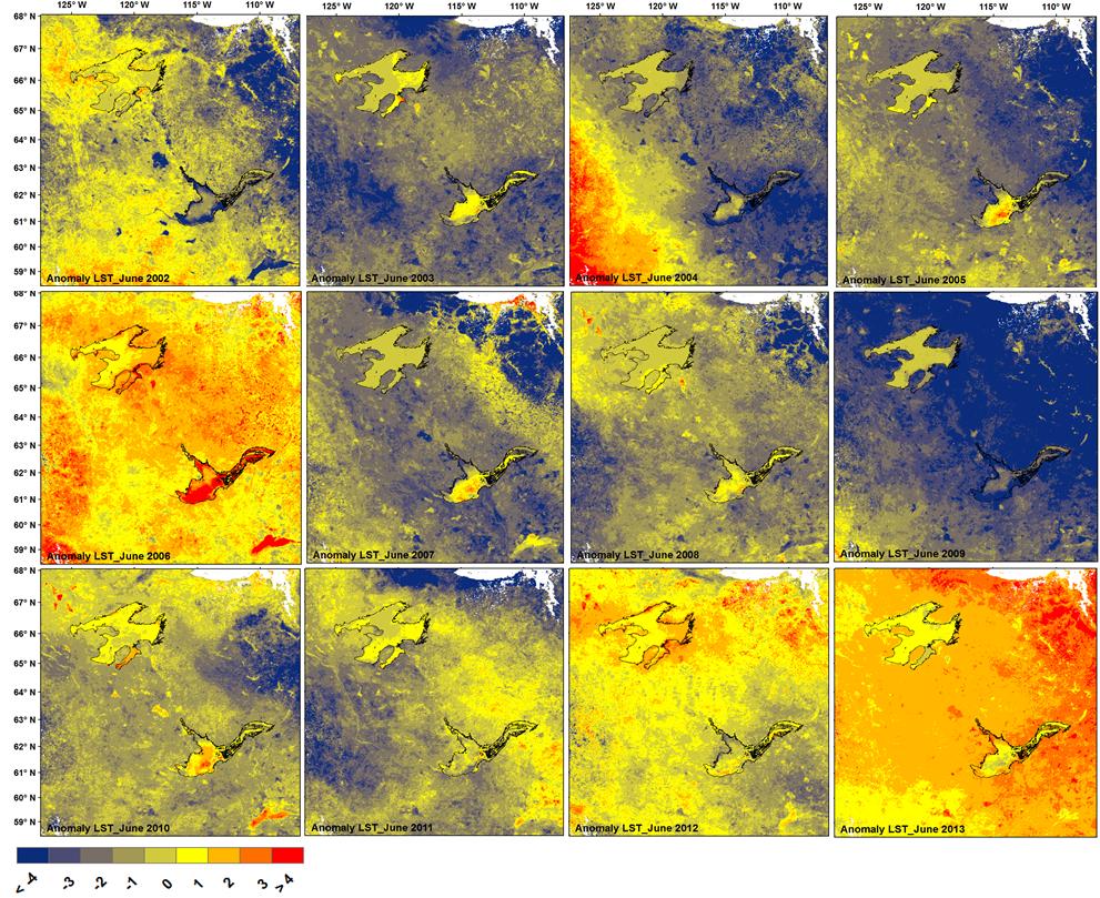
 March April May Derived from UW-L3 LST (25 km x 25")
21 Recent variations observed by MODIS (00-12) Spring (MAM) anomaly (12 vs mean 02-11) March April May Derived from UW-L3 LST (25 km x 25 km)
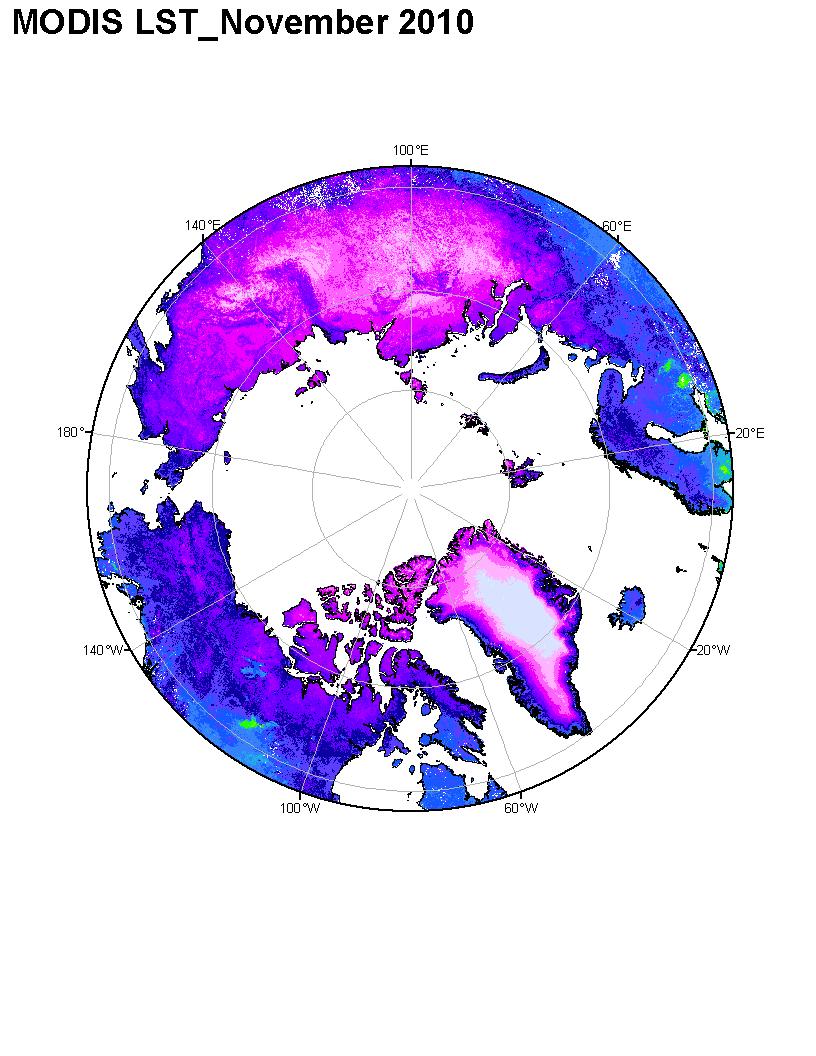
22 MODIS-derived UW-L3 LST (1 km x 1 km) Nov. 11-1km

23 MODIS-derived UW-L3 LSWT (1 km x 1 km) 1-7 Jan. -1km Weekly June 12-1km Monthly
24
25
Satellite-based Lake Surface Temperature (LST) Homa Kheyrollah Pour Claude Duguay
 Homa Kheyrollah Pour Claude Duguay") Satellite-based Lake Surface Temperature (LST) Homa Kheyrollah Pour Claude Duguay Lakes in NWP models Interaction of the atmosphere and underlying layer is the most important issue in climate modeling
Satellite-based Lake Surface Temperature (LST) Homa Kheyrollah Pour Claude Duguay Lakes in NWP models Interaction of the atmosphere and underlying layer is the most important issue in climate modeling
Claude Duguay University of Waterloo
 Claude Duguay University of Waterloo with contributions from K. Kang and H. Kheyrollah Pour 2nd Annual EarthTemp Network Meeting Surface temperature in data-sparse and extreme regions 12-14 June 2013 Copenhagen,
Evaluation and Assimilation of Remotely- Sensed Lake Surface Temperature in the HIRLAM Weather Forecasting System
 Evaluation and Assimilation of Remotely- Sensed Lake Surface Temperature in the HIRLAM Weather Forecasting System H. Kheyrollah Pour 1, C.R. Duguay 1, L. Rontu 2 with contributions from Kalle Eerola 2,
Improvement of objective analysis of lake surface state in HIRLAM using satellite observations
 HIRLAM ASM 2013 & ALADIN 23 rd Workshop Reykjavik, Iceland 15-19 April, 2013 Improvement of objective analysis of lake surface state in HIRLAM using satellite observations H. Kheyrollah Pour, C.R. Duguay
Lake ice cover and surface water temperature II: Satellite remote sensing
 Lake ice cover and surface water temperature II: Satellite remote sensing Claude Duguay University of Waterloo (Canada) Earth Observation Summer School ESA-ESRIN, Frascati, Italy (4-14 August 2014) Lecture
Data assimilation over lakes
 Data assimilation over lakes Ekaterina Kurzeneva 18-20 September 2012,Helsinki, FMI Contents Introduction Lake observations Lake data assimilation: overlook and methods Lake model FLake from DA point of
Lake parameters climatology for cold start runs (lake initialization) in the ECMWF forecast system
 in the ECMWF forecast system") 2nd Workshop on Parameterization of Lakes in Numerical Weather Prediction and Climate Modelling Lake parameters climatology for cold start runs (lake initialization) in the ECMWF forecast system R. Salgado(1),
2nd Workshop on Parameterization of Lakes in Numerical Weather Prediction and Climate Modelling Lake parameters climatology for cold start runs (lake initialization) in the ECMWF forecast system R. Salgado(1),
Parameterization of Lakes in Numerical Weather Prediction models
 Parameterization of Lakes in Numerical Weather Prediction models Dmitri Mironov, Laura Rontu, Ekaterina Kurzeneva & 26 participants of the Lake12 workshop SRNWP-EWGLAM meeting Helsinki 8-11 October 2012
Remote Sensing of SWE in Canada
 Remote Sensing of SWE in Canada Anne Walker Climate Research Division, Environment Canada Polar Snowfall Hydrology Mission Workshop, June 26-28, 2007 Satellite Remote Sensing Snow Cover Optical -- Snow
Remote sensing of snow at SYKE Sari Metsämäki
 Remote sensing of snow at SYKE 2011-01-21 Sari Metsämäki Activities in different projects Snow extent product in ESA DUE-project GlobSnow Long term datasets (15-30 years) on Snow Extent (SE) and Snow Water
On the Use of MODIS for Lake and Land Surface Temperature Investigations in the Regions of Great Bear Lake and Great Slave Lake, N.W.T.
 On the Use of MODIS for Lake and Land Surface Temperature Investigations in the Regions of Great Bear Lake and Great Slave Lake, N.W.T. by Homa Kheyrollah Pour A thesis presented to the University of Waterloo
Comparison of NASA AIRS and MODIS Land Surface Temperature and Infrared Emissivity Measurements from the EOS AQUA platform
 Comparison of NASA AIRS and MODIS Land Surface Temperature and Infrared Emissivity Measurements from the EOS AQUA platform Robert Knuteson, Steve Ackerman, Hank Revercomb, Dave Tobin University of Wisconsin-Madison
ALASKA REGION CLIMATE OUTLOOK BRIEFING. November 17, 2017 Rick Thoman National Weather Service Alaska Region
 ALASKA REGION CLIMATE OUTLOOK BRIEFING November 17, 2017 Rick Thoman National Weather Service Alaska Region Today Feature of the month: More climate models! Climate Forecast Basics Climate System Review
ALASKA REGION CLIMATE OUTLOOK BRIEFING. December 22, 2017 Rick Thoman National Weather Service Alaska Region
 ALASKA REGION CLIMATE OUTLOOK BRIEFING December 22, 2017 Rick Thoman National Weather Service Alaska Region Today s Outline Feature of the month: Autumn sea ice near Alaska Climate Forecast Basics Climate
Interannual variation of MODIS NDVI in Lake Taihu and its relation to climate in submerged macrophyte region
 Yale-NUIST Center on Atmospheric Environment Interannual variation of MODIS NDVI in Lake Taihu and its relation to climate in submerged macrophyte region ZhangZhen 2015.07.10 1 Outline Introduction Data
Snow Cover Applications: Major Gaps in Current EO Measurement Capabilities
 Snow Cover Applications: Major Gaps in Current EO Measurement Capabilities Thomas NAGLER ENVEO Environmental Earth Observation IT GmbH INNSBRUCK, AUSTRIA Polar and Snow Cover Applications User Requirements
Climate Models and Snow: Projections and Predictions, Decades to Days
 Climate Models and Snow: Projections and Predictions, Decades to Days Outline Three Snow Lectures: 1. Why you should care about snow 2. How we measure snow 3. Snow and climate modeling The observational
ALASKA REGION CLIMATE FORECAST BRIEFING. October 27, 2017 Rick Thoman National Weather Service Alaska Region
 ALASKA REGION CLIMATE FORECAST BRIEFING October 27, 2017 Rick Thoman National Weather Service Alaska Region Today Feature of the month: West Pacific Typhoons Climate Forecast Basics Climate System Review
ALASKA REGION CLIMATE OUTLOOK BRIEFING. November 16, 2018 Rick Thoman Alaska Center for Climate Assessment and Policy
 ALASKA REGION CLIMATE OUTLOOK BRIEFING November 16, 2018 Rick Thoman Alaska Center for Climate Assessment and Policy Today s Outline Feature of the month: Southeast Drought Update Climate Forecast Basics
PROJECT REPORT (ASL 720) CLOUD CLASSIFICATION
 CLOUD CLASSIFICATION") PROJECT REPORT (ASL 720) CLOUD CLASSIFICATION SUBMITTED BY- PRIYANKA GUPTA 2011CH70177 RINI KAPOOR 2011CH70179 INDIVIDUAL CONTRIBUTION- Priyanka Gupta- analysed data of region considered in India (West:80,
PROJECT REPORT (ASL 720) CLOUD CLASSIFICATION SUBMITTED BY- PRIYANKA GUPTA 2011CH70177 RINI KAPOOR 2011CH70179 INDIVIDUAL CONTRIBUTION- Priyanka Gupta- analysed data of region considered in India (West:80,
The MODIS Cloud Data Record
 The MODIS Cloud Data Record Brent C. Maddux 1,2 Steve Platnick 3, Steven A. Ackerman 1 Paul Menzel 1, Kathy Strabala 1, Richard Frey 1, 1 Cooperative Institute for Meteorological Satellite Studies, 2 Department
Sierra Weather and Climate Update
 Sierra Weather and Climate Update 2014-15 Kelly Redmond Western Regional Climate Center Desert Research Institute Reno Nevada Yosemite Hydroclimate Workshop Yosemite Valley, 2015 October 8-9 Percent of
Global SWE Mapping by Combining Passive and Active Microwave Data: The GlobSnow Approach and CoReH 2 O
 Global SWE Mapping by Combining Passive and Active Microwave Data: The GlobSnow Approach and CoReH 2 O April 28, 2010 J. Pulliainen, J. Lemmetyinen, A. Kontu, M. Takala, K. Luojus, K. Rautiainen, A.N.
Indian National (Weather) SATellites for Agrometeorological Applications
 SATellites for Agrometeorological Applications") Indian National (Weather) SATellites for Agrometeorological Applications Bimal K. Bhattacharya Agriculture-Terrestrial Biosphere- Hydrology Group Space Applications Centre (ISRO) Ahmedabad 380015, India
Indian National (Weather) SATellites for Agrometeorological Applications Bimal K. Bhattacharya Agriculture-Terrestrial Biosphere- Hydrology Group Space Applications Centre (ISRO) Ahmedabad 380015, India
The Application of Satellite Data i n the Global Surface Data Assimil ation System at KMA
 The Application of Satellite Data i n the Global Surface Data Assimil ation System at KMA Mee-Ja Kim, Hae-Mi Noh, SeiYoung Park, Sangwon Joo KMA/NIMS kimmee74@korea.kr 14 March, 2016 The 4th Workshop on
ADVANCEMENTS IN SNOW MONITORING
 Polar Space Task Group ADVANCEMENTS IN SNOW MONITORING Thomas Nagler, ENVEO IT GmbH, Innsbruck, Austria Outline Towards a pan-european Multi-sensor Snow Product SnowPEx Summary Upcoming activities SEOM
Recent Improvements in the U.S. Navy s Ice Modeling Efforts Using CryoSat-2 Ice Thickness for Model Initialization
 Recent Improvements in the U.S. Navy s Ice Modeling Efforts Using CryoSat-2 Ice Thickness for Model Initialization Richard Allard 1, David Hebert 1, Pamela Posey 1, Alan Wallcraft 1, Li Li 2, William Johnston
REMOTE SENSING OF PERMAFROST IN NORTHERN ENVIRONMENTS
 REMOTE SENSING OF PERMAFROST IN NORTHERN ENVIRONMENTS What is permafrost? What can we monitor with satellite data? Permafrost is an Essential Climate Variable About 25 % of the land surface is underlain
Application of a Land Surface Temperature Validation Protocol to AATSR data. Dar ren Ghent1, Fr ank Göttsche2, Folke Olesen2 & John Remedios1
 Application of a Land Surface Temperature Validation Protocol to AATSR data Dar ren Ghent1, Fr ank Göttsche, Folke Olesen & John Remedios1 1 E a r t h O b s e r v a t i o n S c i e n c e, D e p a r t m
Floating Ice: Progress in Addressing Science Goals
 Polar Floating Ice: Progress in Addressing Science Goals Stephen Howell 1, Leif Toudal Pedersen 2 and Roberto Saldo 3 1 Environment Canada, Climate Research Division, Toronto, Canada 2 Danish Meteorological
Intercomparison of Snow Extent Products from Earth Observation Data
 Intercomparison of Snow Extent Products from Earth Observation Data, Elisabeth Ripper, Gabriele Bippus, Helmut Rott FMI Richard Fernandes Kari Luojus Sari Metsämäki Dorothy Hall David Robinson Bojan Bojkov
SYSTEM BRIEF DAILY SUMMARY
 SYSTEM BRIEF DAILY SUMMARY * ANNUAL MaxTemp NEL (MWH) Hr Ending Hr Ending LOAD (PEAK HOURS 7:00 AM TO 10:00 PM MON-SAT) ENERGY (MWH) INCREMENTAL COST DAY DATE Civic TOTAL MAXIMUM @Max MINIMUM @Min FACTOR
NOAA Snow Map Climate Data Record Generated at Rutgers
 NOAA Snow Map Climate Data Record Generated at Rutgers David A. Robinson Rutgers University Piscataway, NJ Snow Watch 2013 Downsview, Ontario January 29, 2013 December 2012 snow extent departures Motivation
C o p e r n i c u s L a n d M o n i t o r i n g S e r v i c e
 C o p e r n i c u s L a n d M o n i t o r i n g S e r v i c e Integration into existing Snow and Ice Services and draft product specifications Annett BARTSCH b.geos Copernicus High Resolution Snow and
Ice Freeze-up and Break-up Detection of Shallow Lakes in Northern Alaska with Spaceborne SAR
 Remote Sens. 2015, 7, 6133-6159; doi:10.3390/rs70506133 Article OPEN ACCESS remote sensing ISSN 2072-4292 www.mdpi.com/journal/remotesensing Ice Freeze-up and Break-up Detection of Shallow Lakes in Northern
ASSESSMENT OF NORTHERN HEMISPHERE SWE DATASETS IN THE ESA SNOWPEX INITIATIVE
 ASSESSMENT OF NORTHERN HEMISPHERE SWE DATASETS IN THE ESA SNOWPEX INITIATIVE Kari Luojus 1), Jouni Pulliainen 1), Matias Takala 1), Juha Lemmetyinen 1), Chris Derksen 2), Lawrence Mudryk 2), Michael Kern
Examples on Sentinel data applications in Finland, possibilities, plans and how NSDC will be utilized - Snow
 Examples on Sentinel data applications in Finland, possibilities, plans and how NSDC will be utilized - Snow Kari Luojus, Jouni Pulliainen, Jyri Heilimo, Matias Takala, Juha Lemmetyinen, Ali Arslan, Timo
Using VIIRS Land Surface Temperature to Evaluate NCEP North American Mesoscale Model (NAM) Forecast
 Forecast") Using VIIRS Land Surface Temperature to Evaluate NCEP North American Mesoscale Model (NAM) Forecast Zhuo Wang (University of Maryland) Yunyue Yu (NOAA/NESDIS/STAR) Peng Yu (University of Maryland) Yuling
Using VIIRS Land Surface Temperature to Evaluate NCEP North American Mesoscale Model (NAM) Forecast Zhuo Wang (University of Maryland) Yunyue Yu (NOAA/NESDIS/STAR) Peng Yu (University of Maryland) Yuling
Current status of lake modelling and initialisation at ECMWF
 Current status of lake modelling and initialisation at ECMWF G Balsamo, A Manrique Suñen, E Dutra, D. Mironov, P. Miranda, V Stepanenko, P Viterbo, A Nordbo, R Salgado, I Mammarella, A Beljaars, H Hersbach
Global Flood Alert System based on satellite derived rainfall data -Targeting the era of Global Precipitation Measurement (GPM)-
-") Global Flood Alert System based on satellite derived rainfall data -Targeting the era of Global Precipitation Measurement (GPM)- Riko Oki, Misako Kachi (JAXA/EORC) Kazuhiko Fukami (PWRI) and Kazuo Umeda
Global Flood Alert System based on satellite derived rainfall data -Targeting the era of Global Precipitation Measurement (GPM)- Riko Oki, Misako Kachi (JAXA/EORC) Kazuhiko Fukami (PWRI) and Kazuo Umeda
Japanese Programs on Space and Water Applications
 Japanese Programs on Space and Water Applications Tamotsu IGARASHI Remote Sensing Technology Center of Japan June 2006 COPUOS 2006 Vienna International Centre Water-related hazards/disasters may occur
Arctic Regional Ocean Observing System Arctic ROOS Report from 2012
 Arctic Regional Ocean Observing System Arctic ROOS Report from 2012 By Stein Sandven Nansen Environmental and Remote Sensing Center (www.arctic-roos.org) Focus in 2012 1. Arctic Marine Forecasting Center
The MSC Beaufort Wind and Wave Reanalysis
 The MSC Beaufort Wind and Wave Reanalysis Val Swail Environment Canada Vincent Cardone, Brian Callahan, Mike Ferguson, Dan Gummer and Andrew Cox Oceanweather Inc. Cos Cob, CT, USA Introduction: History
Characterization of the Present-Day Arctic Atmosphere in CCSM4
 Characterization of the Present-Day Arctic Atmosphere in CCSM4 Gijs de Boer 1, Bill Chapman 2, Jennifer Kay 3, Brian Medeiros 3, Matthew Shupe 4, Steve Vavrus, and John Walsh 6 (1) (2) (3) (4) ESRL ()
Some NOAA Products that Address PSTG Satellite Observing Requirements. Jeff Key NOAA/NESDIS Madison, Wisconsin USA
 Some NOAA Products that Address PSTG Satellite Observing Requirements Jeff Key NOAA/NESDIS Madison, Wisconsin USA WMO Polar Space Task Group, 4 th meeting, Greenbelt, 30 September 2014 Relevant Missions
Operational systems for SST products. Prof. Chris Merchant University of Reading UK
 Operational systems for SST products Prof. Chris Merchant University of Reading UK Classic Images from ATSR The Gulf Stream ATSR-2 Image, ƛ = 3.7µm Review the steps to get SST using a physical retrieval
Ice Surface temperatures, status and utility. Jacob Høyer, Gorm Dybkjær, Rasmus Tonboe and Eva Howe Center for Ocean and Ice, DMI
 Ice Surface temperatures, status and utility Jacob Høyer, Gorm Dybkjær, Rasmus Tonboe and Eva Howe Center for Ocean and Ice, DMI Outline Motivation for IST data production IST from satellite Infrared Passive
A Report on a Statistical Model to Forecast Seasonal Inflows to Cowichan Lake
 A Report on a Statistical Model to Forecast Seasonal Inflows to Cowichan Lake Prepared by: Allan Chapman, MSc, PGeo Hydrologist, Chapman Geoscience Ltd., and Former Head, BC River Forecast Centre Victoria
NSIDC/Univ. of Colorado Sea Ice Motion and Age Products
 NSIDC/Univ. of Colorado Sea Ice Motion and Age Products Polar Pathfinder Daily 25 km EASE-Grid Sea Ice Motion Vectors, http://nsidc.org/data/nsidc-0116.html Passive microwave, AVHRR, and buoy motions Individual
BMKG Research on Air sea interaction modeling for YMC
 BMKG Research on Air sea interaction modeling for YMC Prof. Edvin Aldrian Director for Research and Development - BMKG First Scientific and Planning Workshop on Year of Maritime Continent, Singapore 27-3
11 days (00, 12 UTC) 132 hours (06, 18 UTC) One unperturbed control forecast and 26 perturbed ensemble members. --
 132 hours (06, 18 UTC) One unperturbed control forecast and 26 perturbed ensemble members. --") APPENDIX 2.2.6. CHARACTERISTICS OF GLOBAL EPS 1. Ensemble system Ensemble (version) Global EPS (GEPS1701) Date of implementation 19 January 2017 2. EPS configuration Model (version) Global Spectral Model
APPENDIX 2.2.6. CHARACTERISTICS OF GLOBAL EPS 1. Ensemble system Ensemble (version) Global EPS (GEPS1701) Date of implementation 19 January 2017 2. EPS configuration Model (version) Global Spectral Model
Drought Characterization. Examination of Extreme Precipitation Events
 Drought Characterization Examination of Extreme Precipitation Events Extreme Precipitation Events During the Drought For the drought years (1999-2005) daily precipitation data was analyzed to find extreme
Land Data Assimilation at NCEP NLDAS Project Overview, ECMWF HEPEX 2004
 Dag.Lohmann@noaa.gov, Land Data Assimilation at NCEP NLDAS Project Overview, ECMWF HEPEX 2004 Land Data Assimilation at NCEP: Strategic Lessons Learned from the North American Land Data Assimilation System
Assimilation of Snow and Ice Data (Incomplete list)
") Assimilation of Snow and Ice Data (Incomplete list) Snow/ice Sea ice motion (sat): experimental, climate model Sea ice extent (sat): operational, U.S. Navy PIPs model; Canada; others? Sea ice concentration
Assimilation of Snow and Ice Data (Incomplete list) Snow/ice Sea ice motion (sat): experimental, climate model Sea ice extent (sat): operational, U.S. Navy PIPs model; Canada; others? Sea ice concentration
The Canadian ADAGIO Project for Mapping Total Atmospheric Deposition
 The Canadian ADAGIO Project for Mapping Total Atmospheric Deposition Amanda S. Cole Environment & Climate Change Canada (ECCC) MMF-GTAD Workshop Geneva, Switzerland February 28, 2017 ADAGIO team Amanda
JPSS GEONETCAST REQUIREMENTS DISCUSSION
 Joint Polar Satellite System (JPSS) JPSS GEONETCAST REQUIREMENTS DISCUSSION Mitch Goldberg Program Scientist Joint Polar Satellite System National Environmental Satellite, Data, and Information Service
Advancements and validation of the global CryoClim snow cover extent product
 www.nr.no Advancements and validation of the global CryoClim snow cover extent product Rune Solberg1, Øystein Rudjord1, Arnt-Børre Salberg1 and Mari Anne Killie2 1) Norwegian Computing Center (NR), P.O.
SYSTEM BRIEF DAILY SUMMARY
 SYSTEM BRIEF DAILY SUMMARY * ANNUAL MaxTemp NEL (MWH) Hr Ending Hr Ending LOAD (PEAK HOURS 7:00 AM TO 10:00 PM MON-SAT) ENERGY (MWH) INCREMENTAL COST DAY DATE Civic TOTAL MAXIMUM @Max MINIMUM @Min FACTOR
The ECMWF coupled data assimilation system
 The ECMWF coupled data assimilation system Patrick Laloyaux Acknowledgments: Magdalena Balmaseda, Kristian Mogensen, Peter Janssen, Dick Dee August 21, 214 Patrick Laloyaux (ECMWF) CERA August 21, 214
NESDIS Polar (Region) Products and Plans. Jeff Key NOAA/NESDIS Madison, Wisconsin USA
 Products and Plans. Jeff Key NOAA/NESDIS Madison, Wisconsin USA") NESDIS Polar (Region) Products and Plans Jeff Key NOAA/NESDIS Madison, Wisconsin USA WMO Polar Space Task Group, 2 nd meeting, Geneva, 12 14 June 2012 Relevant Missions and Products GOES R ABI Fractional
NESDIS Polar (Region) Products and Plans Jeff Key NOAA/NESDIS Madison, Wisconsin USA WMO Polar Space Task Group, 2 nd meeting, Geneva, 12 14 June 2012 Relevant Missions and Products GOES R ABI Fractional
Comparing MERRA surface global solar radiation and diffuse radiation against field observations in Shanghai. Reporter: Yue Kun
 Comparing MERRA surface global solar radiation and diffuse radiation against field observations in hanghai Reporter: Yue Kun 1 OUTLINE 1 Background and Objectives 2 Materials and Methods 3 Results and
GFAS Methodology & Results
 GFAS Methodology & Results Johannes W. Kaiser, Imke Hüser, Berit Gehrke Max Planck Institute for Chemistry, DE Tadas Nikonovas, Weidong Xu, Martin G. Wooster King s College London, UK Ioannis Bistinas,
The importance of long-term Arctic weather station data for setting the research stage for climate change studies
 The importance of long-term Arctic weather station data for setting the research stage for climate change studies Taneil Uttal NOAA/Earth Systems Research Laboratory Boulder, Colorado Things to get out
Aquarius Data Release V2.0 Validation Analysis Gary Lagerloef, Aquarius Principal Investigator H. Kao, ESR And Aquarius Cal/Val Team
 Aquarius Data Release V2.0 Validation Analysis Gary Lagerloef, Aquarius Principal Investigator H. Kao, ESR And Aquarius Cal/Val Team Analysis period: Sep 2011-Dec 2012 SMOS-Aquarius Workshop 15-17 April
Recent ECMWF Developments
 Recent ECMWF Developments Tim Hewson (with contributions from many ECMWF colleagues!) tim.hewson@ecmwf.int ECMWF November 2, 2017 Outline Last Year IFS upgrade highlights 43r1 and 43r3 Standard web Chart
Appendix B. A proposition for updating the environmental standards using real Earth Albedo and Earth IR Flux for Spacecraft Thermal Analysis
 19 Appendix B A proposition for updating the environmental standards using real Earth Albedo and Earth IR Romain Peyrou-Lauga (ESA/ESTEC, The Netherlands) 31 st European Space Thermal Analysis Workshop
Climate Modeling Research & Applications in Wales. John Houghton. C 3 W conference, Aberystwyth
 Climate Modeling Research & Applications in Wales John Houghton C 3 W conference, Aberystwyth 26 April 2011 Computer Modeling of the Atmosphere & Climate System has revolutionized Weather Forecasting and
TAMSAT: LONG-TERM RAINFALL MONITORING ACROSS AFRICA
 TAMSAT: LONG-TERM RAINFALL MONITORING ACROSS AFRICA Ross Maidment, Emily Black, Matthew Young and Dagmawi Asfaw TAMSAT, University of Reading Helen Greatrex IRI, Columbia University 13 th EUMETSAT User
Global climate predictions: forecast drift and bias adjustment issues
 www.bsc.es Ispra, 23 May 2017 Global climate predictions: forecast drift and bias adjustment issues Francisco J. Doblas-Reyes BSC Earth Sciences Department and ICREA Many of the ideas in this presentation
Long-Term Time Series of Water Vapour Total Columns from GOME, SCIAMACHY and GOME-2
 Graphics: ESA Graphics: ESA Graphics: ESA Long-Term Time Series of Water Vapour Total Columns from GOME, SCIAMACHY and GOME-2 S. Noël, S. Mieruch, H. Bovensmann, J. P. Burrows Institute of Environmental
ESA GlobSnow - project overview
 ESA GlobSnow - project overview GCW 1 st Implementation meeting Geneve, 23 Nov. 2011 K. Luojus & J. Pulliainen (FMI) + R. Solberg (NR) Finnish Meteorological Institute 1.12.2011 1 ESA GlobSnow ESA-GlobSnow
Drought in Southeast Colorado
 Drought in Southeast Colorado Nolan Doesken and Roger Pielke, Sr. Colorado Climate Center Prepared by Tara Green and Odie Bliss http://climate.atmos.colostate.edu 1 Historical Perspective on Drought Tourism
We greatly appreciate the thoughtful comments from the reviewers. According to the reviewer s comments, we revised the original manuscript.
 Response to the reviews of TC-2018-108 The potential of sea ice leads as a predictor for seasonal Arctic sea ice extent prediction by Yuanyuan Zhang, Xiao Cheng, Jiping Liu, and Fengming Hui We greatly
Improving numerical sea ice predictions in the Arctic Ocean by data assimilation using satellite observations
 Okhotsk Sea and Polar Oceans Research 1 (2017) 7-11 Okhotsk Sea and Polar Oceans Research Association Article Improving numerical sea ice predictions in the Arctic Ocean by data assimilation using satellite
Analyzing and Visualizing Precipitation and Soil Moisture in ArcGIS
 Analyzing and Visualizing Precipitation and Soil Moisture in ArcGIS Wenli Yang, Pham Long, Peisheng Zhao, Steve Kempler, and Jennifer Wei * NASA Goddard Earth Science Data and Information Services Center
Agricultural Science Climatology Semester 2, Anne Green / Richard Thompson
 Agricultural Science Climatology Semester 2, 2006 Anne Green / Richard Thompson http://www.physics.usyd.edu.au/ag/agschome.htm Course Coordinator: Mike Wheatland Course Goals Evaluate & interpret information,
Assimilation of GlobSnow Data in HIRLAM. Suleiman Mostamandy Kalle Eerola Laura Rontu Katya Kourzeneva
 Assimilation of GlobSnow Data in HIRLAM Suleiman Mostamandy Kalle Eerola Laura Rontu Katya Kourzeneva 10/03/2011 Contents Introduction Snow from satellites Globsnow Other satellites The current study Experiment
The ESA SnowPex project and an introduction to the APVE workshops
 The ESA SnowPex project and an introduction to the APVE workshops Bojan R. Bojkov Head Sensor Performance, Products and Algorithms Directorate of Earth Observation Programmes European Space Agency ESA/ESRIN
Life Cycle of Convective Systems over Western Colombia
 Life Cycle of Convective Systems over Western Colombia Meiry Sakamoto Uiversidade de São Paulo, São Paulo, Brazil Colombia Life Cycle of Convective Systems over Western Colombia Convective System (CS)
Sea ice charts and SAR for sea ice classification. Patrick Eriksson Juha Karvonen Jouni Vainio
 Sea ice charts and SAR for sea ice classification Patrick Eriksson Juha Karvonen Jouni Vainio ECMWF Ocean Workshop, 22-25 January 2018 Ice service from past to present Finland has long experience in ice
Application of EO for Environmental Monitoring at the Finnish Environment Institute
 Application of EO for Environmental Monitoring at the Finnish Environment Institute Data Processing (CalFin) and Examples of Products Markus Törmä Finnish Environment Institute SYKE markus.torma@ymparisto.fi
From short range forecasts to climate change projections of extreme events in the Baltic Sea region
 Great Baltic Sea flood, November 13, 1872 Farm houses in Niendorf (near Lübeck) being torn away. Privately owned, Fam. Muuß, Hotel Friedrichsruh. Sea level 3.50 m above normal. From short range forecasts
ENVISAT - AATSR CYCLIC REPORT #63
 ENVISAT - AATSR CYCLIC REPORT #63 START END DATE 29 OCT 2007 03 DEC 2007 TIME 21:59:29 21:59:29 ORBIT # 29614 30114 Himalayas, 18 November 2007 Daytime visible image showing snow on the Western Himalayas.
Marche Region Climate Analysis by Danilo Tognetti 1
 Marche Region. 2016 Climate Analysis by Danilo Tognetti 1 With the contribution of eight consecutive high monthly temperature records set from January to August, and the remainder of the months ranking
A. Windnagel M. Savoie NSIDC
 National Snow and Ice Data Center ADVANCING KNOWLEDGE OF EARTH'S FROZEN REGIONS Special Report #18 06 July 2016 A. Windnagel M. Savoie NSIDC W. Meier NASA GSFC i 2 Contents List of Figures... 4 List of
Environment and Climate Change Canada / GPC Montreal
 Environment and Climate Change Canada / GPC Montreal Assessment, research and development Bill Merryfield Canadian Centre for Climate Modelling and Analysis (CCCma) with contributions from colleagues at
Recent improvements on the wave forecasting system of Meteo-France: modeling and assimilation aspects
 Recent improvements on the wave forecasting system of Meteo-France: modeling and assimilation aspects L. Aouf and J-M. Lefèvre Division Marine et Océanographie, Météo-France 13 th International workshop
Satellite-derived environmental drivers for top predator hotspots
 Satellite-derived environmental drivers for top predator hotspots Peter Miller @PeterM654 South West Marine Ecosystems 2017 21 Apr. 2017, Plymouth University Satellite environmental drivers for hotspots
Chiang Rai Province CC Threat overview AAS1109 Mekong ARCC
 Chiang Rai Province CC Threat overview AAS1109 Mekong ARCC This threat overview relies on projections of future climate change in the Mekong Basin for the period 2045-2069 compared to a baseline of 1980-2005.
Champaign-Urbana 2000 Annual Weather Summary
 Champaign-Urbana 2000 Annual Weather Summary ILLINOIS STATE WATER SURVEY 2204 Griffith Dr. Champaign, IL 61820 wxobsrvr@sws.uiuc.edu Maria Peters, Weather Observer January: January started on a mild note,
Impact of METOP ASCAT Ocean Surface Winds in the NCEP GDAS/GFS and NRL NAVDAS
 Impact of METOP ASCAT Ocean Surface Winds in the NCEP GDAS/GFS and NRL NAVDAS COAMPS @ Li Bi 1,2 James Jung 3,4 Michael Morgan 5 John F. Le Marshall 6 Nancy Baker 2 Dave Santek 3 1 University Corporation
Analysis of Antarctic Sea Ice Extent based on NIC and AMSR-E data Burcu Cicek and Penelope Wagner
 Analysis of Antarctic Sea Ice Extent based on NIC and AMSR-E data Burcu Cicek and Penelope Wagner 1. Abstract The extent of the Antarctica sea ice is not accurately defined only using low resolution microwave
Development of the Canadian Precipitation Analysis (CaPA) and the Canadian Land Data Assimilation System (CaLDAS)
 and the Canadian Land Data Assimilation System (CaLDAS)") Development of the Canadian Precipitation Analysis (CaPA) and the Canadian Land Data Assimilation System (CaLDAS) Marco L. Carrera, Vincent Fortin and Stéphane Bélair Meteorological Research Division Environment
Development of the Canadian Precipitation Analysis (CaPA) and the Canadian Land Data Assimilation System (CaLDAS) Marco L. Carrera, Vincent Fortin and Stéphane Bélair Meteorological Research Division Environment
Local Ctimatotogical Data Summary White Hall, Illinois
 SWS Miscellaneous Publication 98-5 STATE OF ILLINOIS DEPARTMENT OF ENERGY AND NATURAL RESOURCES Local Ctimatotogical Data Summary White Hall, Illinois 1901-1990 by Audrey A. Bryan and Wayne Armstrong Illinois
Cloud masking as cross-cutting issue
 Cloud masking as cross-cutting issue Presentation to CEOS/WGCV activity project planning meeting Rainer Hollmann, Cornelia Schlundt, Satellite based Climate Monitoring Deutscher Wetterdienst Outline Need
This is version v0.2 of this report issued together with the SIT and SIV data sets at the ICDC ESA-CCI- Projekt web page
 Report about Retrieval of sea-ice volume (SIV) from SICCI-2 sea-ice thickness (SIT) data and combined OSI-450 and SICCI-2 sea-ice concentration (SIC) data version v0.2, June 2018 by Stefan Kern, ICDC,
Circumpolar AVHRR Surface Temperature and its Relationship Bioclimate Zones and NDVI
 Circumpolar AVHRR Surface Temperature and its Relationship Bioclimate Zones and NDVI Martha Raynolds, Donald A. Walker, University of Alaska Fairbanks Overview of Presentation Two data sets: Circumpolar
Feature resolution in OSTIA L4 analyses. Chongyuan Mao, Emma Fiedler, Simon Good, Jennie Waters, Matthew Martin
 Feature resolution in OSTIA L4 analyses Chongyuan Mao, Emma Fiedler, Simon Good, Jennie Waters, Matthew Martin GHRSST XVIII, Qingdao, China, 5-9 June 2017 Talk outline Introduction NEMOVAR in OSTIA Methods
Inter-linkage case study in Pakistan
 7 th GEOSS Asia Pacific Symposium GEOSS AWCI Parallel Session: 26-28 May, 2014, Tokyo, Japan Inter-linkage case study in Pakistan Snow and glaciermelt runoff modeling in Upper Indus Basin of Pakistan Maheswor
Evaluation of updated JXAM5 snow cover extent product using ground based snow depth information
 2 nd International Satellite Snow Product Intercomparison Workshop ISSPI-2 University Memorial Center (UMC), University of Colorado Boulder, 14-16 September 2015 Evaluation of updated JXAM5 snow cover