Radar Remote Sensing: Monitoring Ground Deformations and Geohazards from Space
|
|
|
- Arthur Jackson
- 6 years ago
- Views:
Transcription


1 Radar Remote Sensing: Monitoring Ground Deformations and Geohazards from Space Xiaoli Ding Department of Land Surveying and Geo-Informatics The Hong Kong Polytechnic University

2 A Question 100 km 100 km
3 InSAR Interferometric Synthetic Aperture Radar A radar remote sensing technology, capable of measuring large-area deformations with high resolution and accuracy


4 Working Process of InSAR Ground station SAR images Deformation measurements Users


 SAR")
5 GPS Satellite Radar Antennas (Phased Array Antennas) SAR Satellites
6 SAR Imaging Active remote sensing Some ability of penetration Two components of results: amplitude and phase 6
7 Amplitude component Phase component
8 φ π 0 π
9 Applications of SAR Images Change detection Environmental and agricultural applications Military applications Interferometric applications 9
 R 2 Interference fringes Double-slit experiment (Thomas")
10 Interferometry and InSAR Concept of Interferometry: R 1 Constructive (in phase) Destructive (out of phase) R 2 Interference fringes Double-slit experiment (Thomas Young, 1801) 10

11 Concept of InSAR: R 1 R 2 Interference fringes
12 π 0 π SAR Interferometry Amplitude Master Slave Phase

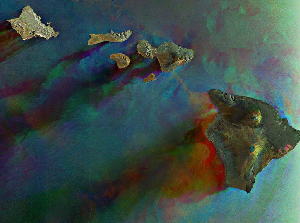
13 SAR Interferometry Interferogram - = π 0 π
14 SAR Interferogram Contains information on Topography Surface deformation Systematic errors Noises The method has been explored for many applications since about 20 years ago 14

15 1st Spaceborne InSAR DEM Result Topographic map of Cottonball Basin in Death Valley (Zebker et al.,1988) 15
")
16 1st InSAR Deformation Measurement Salton Sea area, south California (Zebker et al, 1989 ) 16
 17")
17 1st InSAR Earthquake Study The displacement field of Landers earthquake (Massonnet et al., 1993) 17
 NASA/JPL s space shuttle")

18 SRTM Mission Shuttle Radar Topography Mission (SRTM) NASA/JPL s space shuttle InSAR system Launched on Feb. 11, m Radar 1 GPS Receiver C/X band SAR Radar 2 18

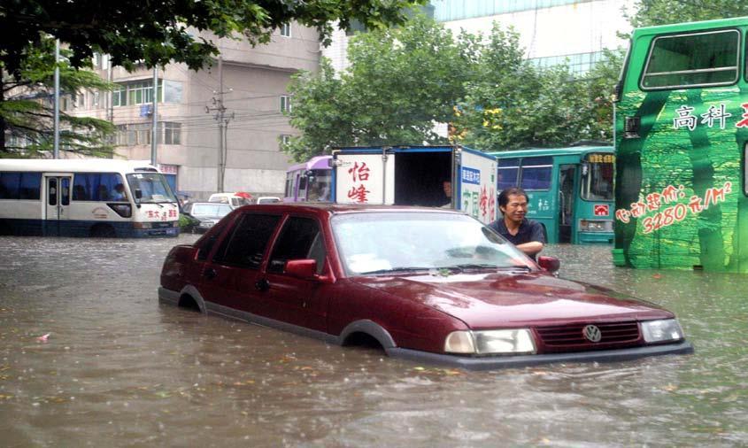
 Dual")
19 Flew for 11 days km fly height,57 o imaging angle Cover almost all land area (60 o N to 60 o S) Dual frequency (C and X)
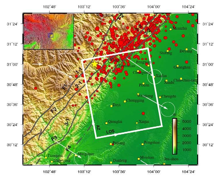
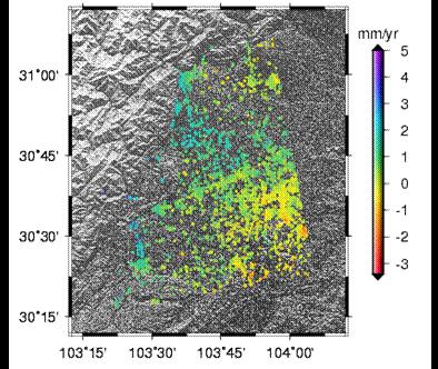
20 Co-seismic ground deformation associated with Sichuan earthquake in 2008
21


22 Kilauea volcano, Hawaii (Courtesy NASA/JPL)

23 In the late 1990s, InSAR was used to map the deformation of volcanoes during quiescent periods. InSAR-derived surface deformation patterns shed important insights into the structure, plumbing, and state of restless volcanoes (Lu, 2007)
24


25 Ice-Sheet Motion Goldstein et al., 1993, JPL Rutford, Antarctic 25
 0-5 -10-15 -25-30 -40-50 Settlement map near 1 year (1999) Lam Chau Chek")
26 Settlement of HK Airport (mm) Settlement map near 1 year (1999) Lam Chau Chek Lap Kok


27 Accumulative Subsidence in Shanghai

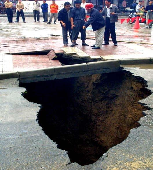
28 Ground Subsidence in Xi an in 05-06
29 29

30


31 Ground Subsidence is a Global Problem In the United States, more than 17,000 square miles in 45 States

32 Land Subsidence in California Joe Poland, USGS scientist shows subsidence from 1925 and miles southwest of Mendota, CA. Sign reads "San Joaquin Valley California, BM S661, Subsidence 9M, " From USGS Professional Paper 1401-A, "Ground water in the Central Valley, California- A summary report" Photo by Dick Ireland, USGS, ok/hydrosphere/subsurface_water_groundwater.html

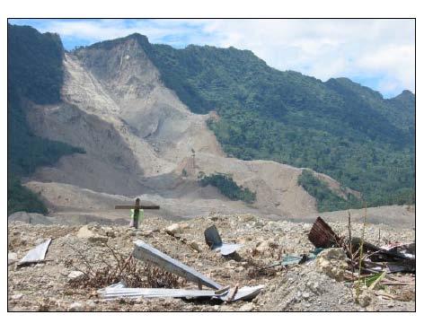
33 Landslide Monitoring Interferometric SAR images could provide information on detail slope profiles of the large rock slides occurring on steep slopes and along faults. From the interferograms, faults, rock slumps, block slides, slide scars and debris slopes could be identified displacement image of the landslide of La Valette from to
34 Shortcomings of Traditional InSAR Significantly affected by ground conditions Affected by the atmosphere 34
35 InSAR will not work in heavily vegetated areas! X band (λ = 3.1 cm) C band (λ = 5.6 cm) L band (λ = 23.5 cm)
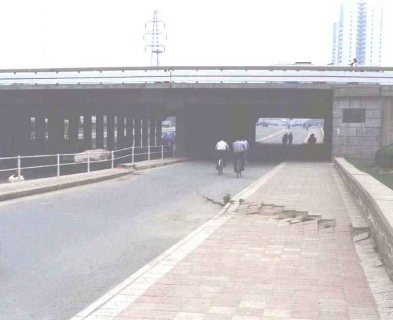
36 36


37 InSAR does not work well for sites disturbed too much


38 InSAR does not work in steep terrains!

39 InSAR does not work if the surface measured is too smooth!

40 InSAR does not work if the area is too small or a surface does not oriented properly!

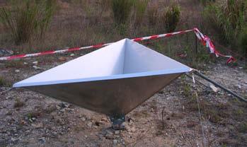
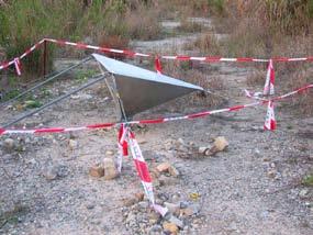
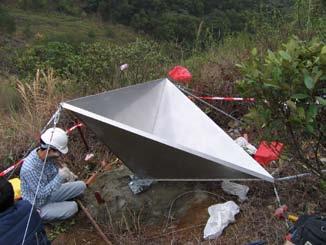
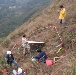
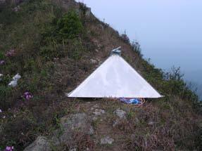
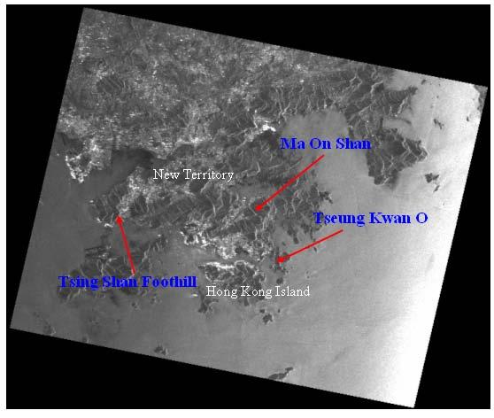
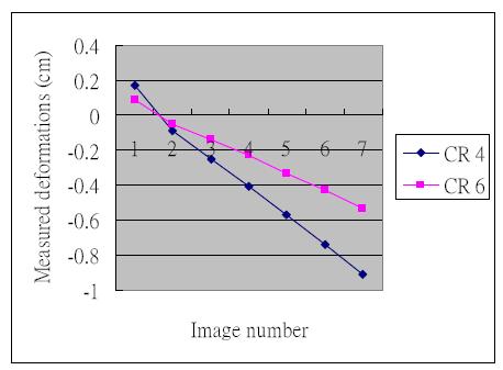
41 (a) Atmospheric artifacts in deformation measurements!
42 Recent InSAR Research Efforts Enhance the performance of InSAR by overcoming its problems Apply InSAR to study various scientific and engineering problems InSAR research community is increasing rapidly 42

43 (Rott, 2005) Persistent Scatterer InSAR (PSInSAR) Using a times series of SAR images to get solution in time domain First proposed by Ferretti et al. (2001) 43
")
44 (Courtesy of TRE)
")
45 (Courtesy of TRE) 45

46 Subsidence in Southern Taiwan from PSInSAR

47 Subsidence in Southern California from Triple-Difference PSInSAR

48 Comparison with GPS Results 48

49 Shanghai Subsidence ( ) from TCP-InSAR TCP Temporary Coherence Points 12 SAR images were used for this study 49 49


50 Bridge Monitoring with TCP- InSAR Only 4 SAR images were used for this study Deformation of up to 1.2cm between January-July 2009 was detected 50 50
51
 19/02/1996 20/02/1996 (b) 25/03/1996")

52 Study of Atmospheric Effects on InSAR Unit: mm (a) 19/02/ /02/1996 (b) 25/03/ /03/1996 In each interferogram a square region of 50 km 50 km is chosen for further study 52
53 Tropospheric Delay Modeling 53

54 Ionospheric effects on co-seismic deformation Measurements - Sichuan earthquake in 2008

55 Corner Reflector InSAR
56 InSAR Related Publications In SCI Database < (May) 56
57 InSAR Research Topics ( ) Earthquake Glacier motion Vocalno Urban subsidence DEM generation Land cover classification Forest mapping Landslides Atmospheric correction Wetland 57
58 Summary InSAR is one of the most powerful geodetic technologies Capability of InSAR is increasing rapidly There are still problems with the technology There will be more and wider applications of the technology 58
Urban land and infrastructure deformation monitoring by satellite radar interferometry
 Urban land and infrastructure deformation monitoring by satellite radar interferometry Lei Zhang and Xiaoli Ding Department of Land Surveying and Geo-Informatics (LSGI) The Hong Kong Polytechnic University
RADAR Remote Sensing Application Examples
 RADAR Remote Sensing Application Examples! All-weather capability: Microwave penetrates clouds! Construction of short-interval time series through cloud cover - crop-growth cycle! Roughness - Land cover,
Interferometric Synthetic Aperture Radar (InSAR): Its Past, Present and Future
: Its Past, Present and Future") Interferometric Synthetic Aperture Radar (InSAR): Its Past, Present and Future by Zhong Lu, Ohig Kwoun, and Russell Rykhus Introduction Very simply, interferometric synthetic aperture radar (InSAR) involves
Interferometric Synthetic Aperture Radar (InSAR): Its Past, Present and Future by Zhong Lu, Ohig Kwoun, and Russell Rykhus Introduction Very simply, interferometric synthetic aperture radar (InSAR) involves
CRUSTAL DYNAMICS IN CALIFORNIA: IMPLICATIONS FOR LARGE-SCALE CSP TOWER SYSTEMS
 CRUSTAL DYNAMICS IN CALIFORNIA: IMPLICATIONS FOR LARGE-SCALE CSP TOWER SYSTEMS Clement Ogaja Department of Civil & Geomatics Engineering California State University, Fresno Introduction Clement Ogaja Department
SAR interferometry Status and future directions. Rüdiger Gens
 SAR interferometry Status and future directions Rüdiger Gens Polarimetric InSAR Polarimetric InSAR InSAR - Status and future directions sensitivity to changes in surface scattering, even in the presence
Tandem-L: A Mission Proposal for Monitoring Dynamic Earth Processes
 Tandem-L: A Mission Proposal for Monitoring Dynamic Earth Processes A. Moreira, G. Krieger, M. Younis, I. Hajnsek, K. Papathanassiou, M. Eineder, P. Dekker, F. De Zan German Aerospace Center (DLR) Dynamic
The financial and communal impact of a catastrophe instantiated by. volcanoes endlessly impact on lives and damage expensive infrastructure every
 Chapter 1 Introduction The financial and communal impact of a catastrophe instantiated by geophysical activity is significant. Landslides, subsidence, earthquakes and volcanoes endlessly impact on lives
DIFFERENTIAL INSAR STUDIES IN THE BOREAL FOREST ZONE IN FINLAND
 DIFFERENTIAL INSAR STUDIES IN THE BOREAL FOREST ZONE IN FINLAND Kirsi Karila (1,2), Mika Karjalainen (1), Juha Hyyppä (1) (1) Finnish Geodetic Institute, P.O. Box 15, FIN-02431 Masala, Finland, Email:
Modeling of Atmospheric Effects on InSAR Measurements With the Method of Stochastic Simulation
 Modeling of Atmospheric Effects on InSAR Measurements With the Method of Stochastic Simulation Z. W. LI, X. L. DING Department of Land Surveying and Geo-Informatics, Hong Kong Polytechnic University, Hung
Deformation measurement using SAR interferometry: quantitative aspects
 Deformation measurement using SAR interferometry: quantitative aspects Michele Crosetto (1), Erlinda Biescas (1), Ismael Fernández (1), Ivan Torrobella (1), Bruno Crippa (2) (1) (2) Institute of Geomatics,
CHAPTER-7 INTERFEROMETRIC ANALYSIS OF SPACEBORNE ENVISAT-ASAR DATA FOR VEGETATION CLASSIFICATION
 147 CHAPTER-7 INTERFEROMETRIC ANALYSIS OF SPACEBORNE ENVISAT-ASAR DATA FOR VEGETATION CLASSIFICATION 7.1 INTRODUCTION: Interferometric synthetic aperture radar (InSAR) is a rapidly evolving SAR remote
Implementation of Multi-Temporal InSAR to monitor pumping induced land subsidence in Pingtung Plain, Taiwan
 Implementation of Multi-Temporal InSAR to monitor pumping induced land subsidence in Pingtung Plain, Taiwan Presenter: Oswald Advisor: Chuen-Fa Ni Date: March 09, 2017 Literature Review Pingtung Plain
High-resolution temporal imaging of. Howard Zebker
 High-resolution temporal imaging of crustal deformation using InSAR Howard Zebker Stanford University InSAR Prehistory SEASAT Topographic Fringes SEASAT Deformation ERS Earthquake Image Accurate imaging
ERS-ENVISAT Cross-interferometry for Coastal DEM Construction
 ERS-ENVISAT Cross-interferometry for Coastal DEM Construction Sang-Hoon Hong and Joong-Sun Won Department of Earth System Sciences, Yonsei University, 134 Shinchon-dong, Seodaemun-gu, 120-749, Seoul, Korea
Interferometric Synthetic Aperture Radar (InSAR) and GGOS. Andrea Donnellan NASA/JPL February 21, 2007
 and GGOS. Andrea Donnellan NASA/JPL February 21, 2007") Interferometric Synthetic Aperture Radar (InSAR) and GGOS Andrea Donnellan NASA/JPL February 21, 2007 Sources for Science Objectives Fourth component of EarthScope Involvement: NSF, NASA, USGS, Universities
Interferometric Synthetic Aperture Radar (InSAR) and GGOS Andrea Donnellan NASA/JPL February 21, 2007 Sources for Science Objectives Fourth component of EarthScope Involvement: NSF, NASA, USGS, Universities
GPS and GIS Assisted Radar Interferometry
 GPS and GIS Assisted Radar Interferometry Linlin Ge, Xiaojing Li, Chris Rizos, and Makoto Omura Abstract Error in radar satellite orbit determination is a common problem in radar interferometry (INSAR).
Subsidence-induced fault
 Surveying Monitoring underground coal mining-induced subsidence by Yaobin Sheng, Linlin Ge, Chris Rizos, University of New South Wales, and Yunjia Wang, China University of Mining and Technology This paper
MAPPING DEFORMATION OF MAN-MADE LINEAR FEATURES USING DINSAR TECHNIQUE
 MAPPING DEFORMATION OF MAN-MADE LINEAR FEATURES USING DINSAR TECHNIQUE H. Wu a, *, Y. Zhang a, J. Zhang a, X. Chen b a Key Laboratory of Mapping from Space of State Bureau of Surveying and Mapping, Chinese
Slow Deformation of Mt. Baekdu Stratovolcano Observed by Satellite Radar Interferometry
 Slow Deformation of Mt. Baekdu Stratovolcano Observed by Satellite Radar Interferometry Sang-Wan Kim and Joong-Sun Won Department of Earth System Sciences, Yonsei University 134 Shinchon-dong, Seodaemun-gu,
Dr. Simon Plank. German Remote Sensing Data Center (DFD), German Aerospace Center (DLR)
, German Aerospace Center (DLR)") Pre-survey suitability analysis of the differential and persistent scatterer synthetic ti aperture radar interferometry t method for deformation monitoring of landslides Dr. Simon Plank German Remote Sensing
Pre-survey suitability analysis of the differential and persistent scatterer synthetic ti aperture radar interferometry t method for deformation monitoring of landslides Dr. Simon Plank German Remote Sensing
NOTES AND CORRESPONDENCE Segmented Faulting Process of Chelungpu Thrust: Implication of SAR Interferograms
 , Vol. 14, No.2, 241-247, June 2003 NOTES AND CORRESPONDENCE Segmented Faulting Process of Chelungpu Thrust: Implication of SAR Interferograms Chien-Chih Chen 1,*, Chung-Pai Chang 2, and Kun-Shan Chen
Surface Deformation Measurements Scientific Requirements & Challenges
 Surface Deformation Measurements Scientific Requirements & Challenges 1st Science and Application Workshop for Germany-Japan Next-Generation SAR M. Eineder, C. Minet, A. Parizzi Tokyo, 27.6.2013 Tandem-L
In order to obtain a long term monitoring result for the Kilauea Volcano, ALOS PALSAR images taken on Track 287, Frame 38, ascending orbit with 21.5 d
 ALOS PALSAR OBSERVATION OF KILAUEA VOLCANO ACTIVITIES FROM 2006 TO 2009 Zhe Hu, Linlin Ge, Xiaojing Li, Kui Zhang, Alex Hay-Man NG and Chris Rizos Cooperative Research Centre for Spatial Information &
ERS Track 98 SAR Data and InSAR Pairs Used in the Analysis
 ERS Track 98 SAR Data and InSAR Pairs Used in the Analysis Date 1 Date 2 Date 1 Date 2 Date 1 Date 2 Date 1 Date 2 7/17/1992 6/19/2000 7/17/1992 7/2/1993 9/10/1993 10/28/1996 9/3/1995 10/18/1999 9/25/1992
Detecting Illegal Mining Activities Using DInSAR
 Detecting Illegal Mining Activities Using DInSAR H.S. Kutoglu 1, H. Akcin 1, T. Deguchi 2, H. Kemaldere 1 1 Zonguldak Karaelmas Universitesi,, Türkiye; T 2 ERSDAC, Japan 17.06.2008 TS4D_3031 Study Area
Atmospheric Effects on InSAR Measurements in Southern China and Australia: A Comparative Study
 Atmospheric Effects on InSAR Measurements in Southern China and Australia: A Comparative Study X. L. Ding a, *, L. Ge b, Z. W. Li a, C. Rizos b a Dept. of Land Surveying and Geo-Informatics, Hong Kong
Measuring rock glacier surface deformation using SAR interferometry
 Permafrost, Phillips, Springman & Arenson (eds) 2003 Swets & Zeitlinger, Lisse, ISBN 90 5809 582 7 Measuring rock glacier surface deformation using SAR interferometry L.W. Kenyi Institute for Digital Image
Publication V Finnish Society of Photogrammetry and Remote Sensing (FSPRS)
") Publication V Kirsi Karila, Mika Karjalainen, and Juha Hyyppä. 2005. Urban land subsidence studies in Finland using synthetic aperture radar images and coherent targets. The Photogrammetric Journal of
Publication V Kirsi Karila, Mika Karjalainen, and Juha Hyyppä. 2005. Urban land subsidence studies in Finland using synthetic aperture radar images and coherent targets. The Photogrammetric Journal of
GEO-HAZARDS STUDIES BY PALSAR INTERFEROMETRY PI No: 390 Xiaoli Ding 1, Lei Zhang 1, Guangcai Feng 1, Mi Jiang 1, and Jun Hu 2, 1 The Hong Kong Polytec
 GEO-HAZARDS SUDIES BY PALSAR INERFEROMERY PI No: 390 Xiaoli Ding 1, Lei Zhang 1, Guangcai Feng 1, Mi Jiang 1, and Jun Hu 2, 1 he Hong Kong Polytechnic University, Hung Hom, KLN, Hong Kong 2 Central South
Interferometers of synthetic aperture radar (InSAR) relevance in generation of digital elevation model (DEM) for real world solutions
 relevance in generation of digital elevation model (DEM) for real world solutions") ISSN: 2455-4227 Impact Factor: RJIF 5.12 www.allsciencejournal.com Volume 2; Issue 5; September 2017; Page No. 143-148 Interferometers of synthetic aperture radar (InSAR) relevance in generation of digital
ISSN: 2455-4227 Impact Factor: RJIF 5.12 www.allsciencejournal.com Volume 2; Issue 5; September 2017; Page No. 143-148 Interferometers of synthetic aperture radar (InSAR) relevance in generation of digital
Ground deformation monitoring in Pearl River Delta region with Stacking D-InSAR technique
 Ground deformation monitoring in Pearl River Delta region with Stacking DInSAR technique Zhao Qing*, LIN Hui, JIANG Liming Institute of Space and Earth Information Science, Room 615, Esther Lee Building,
sensors ISSN
 Sensors 008, 8, 546-5448; DOI: 10.3390/s809546 OPEN ACCESS sensors ISSN 144-80 www.mdpi.org/sensors Review Atmospheric Effects on InSAR Measurements and Their Mitigation Xiao-li Ding 1, *, Zhi-wei Li,
Journal of Geodynamics
 Journal of Geodynamics 49 (2010) 161 170 Contents lists available at ScienceDirect Journal of Geodynamics journal homepage: http://www.elsevier.com/locate/jog Recent advances on surface ground deformation
to: Interseismic strain accumulation and the earthquake potential on the southern San
 Supplementary material to: Interseismic strain accumulation and the earthquake potential on the southern San Andreas fault system by Yuri Fialko Methods The San Bernardino-Coachella Valley segment of the
Earth Observatory of Singapore. Nina Lin 22 Jan 2018
 Earth Observatory of Singapore Nina Lin 22 Jan 2018 EOS Our Mission Our Mission Director Prof. Kerry Sieh The Earth Observatory of Singapore conducts fundamental research on earthquakes, volcanic eruptions,
ALOS PI Symposium 2009, 9-13 Nov 2009 Hawaii MOTION MONITORING FOR ETNA USING ALOS PALSAR TIME SERIES
 ALOS PI Symposium 2009, 9-13 Nov 2009 Hawaii ALOS Data Nodes: ALOS RA-094 and RA-175 (JAXA) MOTION MONITORING FOR ETNA USING ALOS PALSAR TIME SERIES Urs Wegmüller, Charles Werner and Maurizio Santoro Gamma
Two-pass DInSAR uses an interferometric image pair and an external digital elevation model (DEM). Among the two singlelook complex (SLC) images, one i
. Among the two singlelook complex (SLC) images, one i") DIFFERENTIAL RADAR INTERFEROMETRY AND ITS APPLICATION IN MONITORING UNDERGROUND COAL MINING-INDUCED SUBSIDENCE Yaobin Sheng a, b, c, *, Yunjia Wang a, b, Linlin Ge c, Chris Rizos c a Jiangsu Key Laboratory
DIFFERENTIAL RADAR INTERFEROMETRY AND ITS APPLICATION IN MONITORING UNDERGROUND COAL MINING-INDUCED SUBSIDENCE Yaobin Sheng a, b, c, *, Yunjia Wang a, b, Linlin Ge c, Chris Rizos c a Jiangsu Key Laboratory
DLR s TerraSAR-X contributes to international fleet of radar satellites to map the Arctic and Antarctica
 DLR s TerraSAR-X contributes to international fleet of radar satellites to map the Arctic and Antarctica The polar regions play an important role in the Earth system. The snow and ice covered ocean and
SCIENTIFIC REPORT NERC GEF
 SCIENTIFIC REPORT NERC GEF Loan 927 Measuring changes in the dynamics of Pine Island Glacier, Antarctica A.M. Smith & E.C. King, British Antarctic Survey (BAS) pp J.B.T. Scott ABSTRACT A brief period of
Speaker: Ing. Giorgio Barsacchi. Kinematics of the Slumgullion Landslide Revealed by Ground based InSAR Surveys
 Kinematics of the Slumgullion Landslide revealed by Ground based InSAR Survey Speaker: Ing. Giorgio Barsacchi Giorgio Barsacchi Kinematics of the Slumgullion Landslide Revealed by Ground based InSAR Surveys
Available online at GHGT-9. Detection of surface deformation related with CO 2 injection by DInSAR at In Salah, Algeria
 Available online at www.sciencedirect.com Energy Procedia 100 (2009) (2008) 2177 2184 000 000 Energy Procedia www.elsevier.com/locate/procedia www.elsevier.com/locate/xxx GHGT-9 Detection of surface deformation
3-Dimension Deformation Mapping from InSAR & Multiaperture. Hyung-Sup Jung The Univ. of Seoul, Korea Zhong Lu U.S. Geological Survey, U.S.A.
 3-Dimension Deformation Mapping from InSAR & Multiaperture InSAR Hyung-Sup Jung The Univ. of Seoul, Korea Zhong Lu U.S. Geological Survey, U.S.A. Outline Introduction to multiple-aperture InSAR (MAI) 3-D
GSNL - Geohazard Supersites and Natural Laboratories. Biennial report for Candidate/Permanent Supersite. Hawaiʻi Supersite. Annex to report
 Introduction Biennial report for Candidate/Permanent Supersite Hawaiʻi Supersite Annex to 2014 2016 report During 2014 2016, the Hawaiʻi Supersite achieved a number of noteworthy results. This annex details
SNOW MASS RETRIEVAL BY MEANS OF SAR INTERFEROMETRY
 SNOW MASS RETRIEVAL BY MEANS OF SAR INTERFEROMETRY Helmut Rott (1), Thomas Nagler (1), Rolf Scheiber (2) (1) ENVEO, Environmental Earth Observation OEG, Exlgasse 39, A-6020 Innsbruck, Austria E-mail: Helmut.Rott@enveo.at
VALIDATION OF THE PERMANENT SCATTERERS TECHNIQUE IN URBAN AREAS
 VALIDATION OF THE PERMANENT SCATTERERS TECHNIQUE IN URBAN AREAS Alessandro Ferretti, Claudio Prati, Fabio Rocca, Carlo Colesanti Dipartimento di Elettonica e Informazione Politecnico di Milano Piazza L.
PERSISTENT SCATTERER SAR INTERFEROMETRY APPLICATIONS ON LANDSLIDES IN CARPATHIANS (SOUTHERN POLAND)
") Acta Geodyn. Geomater., Vol. 7, No. 3 (159), 1 7, 2010 PERSISTENT SCATTERER SAR INTERFEROMETRY APPLICATIONS ON LANDSLIDES IN CARPATHIANS (SOUTHERN POLAND) Zbigniew PERSKI 1) *, Tomasz WOJCIECHOWSKI 1)
Acta Geodyn. Geomater., Vol. 7, No. 3 (159), 1 7, 2010 PERSISTENT SCATTERER SAR INTERFEROMETRY APPLICATIONS ON LANDSLIDES IN CARPATHIANS (SOUTHERN POLAND) Zbigniew PERSKI 1) *, Tomasz WOJCIECHOWSKI 1)
GEO-VIII November Geohazard Supersites and Natural Laboratories Progress Report. Document 9
 GEO-VIII 16-17 November 2011 Geohazard Supersites and Natural Laboratories Progress Report Document 9 This document is submitted to GEO-VIII for information. Geohazard Supersites and Natural Laboratories
THREE DIMENSIONAL DETECTION OF VOLCANIC DEPOSIT ON MOUNT MAYON USING SAR INTERFEROMETRY
 ABSTRACT THREE DIMENSIONAL DETECTION OF VOLCANIC DEPOSIT ON MOUNT MAYON USING SAR INTERFEROMETRY Francis X.J. Canisius, Kiyoshi Honda, Mitsuharu Tokunaga and Shunji Murai Space Technology Application and
Mitigation of Atmospheric Water-vapour Effects on Spaceborne Interferometric SAR Imaging through the MM5 Numerical Model
 PIERS ONLINE, VOL. 6, NO. 3, 2010 262 Mitigation of Atmospheric Water-vapour Effects on Spaceborne Interferometric SAR Imaging through the MM5 Numerical Model D. Perissin 1, E. Pichelli 2, R. Ferretti
Subsidence Monitoring in Hampton Roads Using Satellites
 ODU Digital Commons July 29, 2016: The Latest in Sea Level Rise Science Hampton Roads Sea Level Rise/Flooding Adaptation Forum 7-29-2016 Subsidence Monitoring in Hampton Roads Using Satellites Ben Hamlington
Integration of InSAR and GIS for Monitoring of Subsidence Induced by Block Caving Mining
 Integration of InSAR and GIS for Monitoring of Subsidence Induced by Block Caving Mining Dr. Andrew JAROSZ and Mr. Hani ZAHIRI, Australia Key words: subsidence, block caving, mine deformation, GIS, InSAR,
Supplementary information. Analytical Techniques and Measurement Uncertainty
 Supplementary information Analytical Techniques and Measurement Uncertainty Interferomeric SAR (InSAR) allows measurement of millimetre-level surface displacements, including land subsidence, in the radar
Objectives and hypotheses. Remote sensing: applications for landslide hazard assessment and risk management. Ping Lu (University of Firenze) Methods
 Methods") Topical Workshop Remote sensing: applications for landslide hazard assessment and risk management Ping Lu (University of Firenze) Supervisors: Prof. Nicola Casagli; Prof. Filippo Catani (Unifi) Dr. Veronica
Topical Workshop Remote sensing: applications for landslide hazard assessment and risk management Ping Lu (University of Firenze) Supervisors: Prof. Nicola Casagli; Prof. Filippo Catani (Unifi) Dr. Veronica
Gets Boost from a New Satellite
 Earthquake Monitoring Gets Boost from a New Satellite By J. R. Elliott, A. J. Elliott, A. Hooper, Y. Larsen, P. Marinkovic, T. J. Wright Fig. 1. Sentinel-1A interferogram built by comparing scans near
Making a case for full-polarimetric radar remote sensing
 Making a case for full-polarimetric radar remote sensing Jeremy Nicoll Alaska Satellite Facility, University of Alaska Fairbanks 1 Polarization States of a Coherent Plane Wave electric field vector vertically
Estimation of Velocity of the Polar Record Glacier, Antarctica Using Synthetic Aperture Radar (SAR)
") Proceedings Estimation of Velocity of the Polar Record Glacier, Antarctica Using Synthetic Aperture Radar (SAR) Prashant H. Pandit 1, *, Shridhar D. Jawak 2 and Alvarinho J. Luis 2 1 Department of Natural
Proceedings Estimation of Velocity of the Polar Record Glacier, Antarctica Using Synthetic Aperture Radar (SAR) Prashant H. Pandit 1, *, Shridhar D. Jawak 2 and Alvarinho J. Luis 2 1 Department of Natural
Early Warning and Earthquake Monitoring Using New Earth Observation Radar Techniques
 Early Warning and Earthquake Monitoring Using New Earth Observation Radar Techniques APSCO Third International Symposium on Earth Quake Monitoring and Early Warning by Using Space Technology Beijing, China
The PaTrop Experiment
 Improved estimation of the tropospheric delay component in GNSS and InSAR measurements in the Western Corinth Gulf (Greece), by the use of a highresolution meteorological model: The PaTrop Experiment N.
EO Information Services in support of Satellite Tools for Building Flood Defence Systems in Guyana
 EO Information Services in support of Satellite Tools for Building Flood Defence Systems in Guyana F. N. Koudogbo and A. Arnaud Altamira Information J. Leen, Eurosense World Bank HQ, Washington DC Date
DETECTING ICE MOTION IN GROVE MOUNTAINS, EAST ANTARCTICA WITH ALOS/PALSAR AND ENVISAT/ASAR DATA
 DETECTING ICE MOTION IN GROVE MOUNTAINS, EAST ANTARCTICA WITH ALOS/PALSAR AND ENVISAT/ASAR DATA TIAN Xin (1), LIAO Mingsheng (1), ZHOU Chunxia (2), ZHOU Yu (3) (1) State Key Laboratory of Information Engineering
Generation and Validation of Digital Elevation Model using ERS - SAR Interferometry Remote Sensing Data
 Jour. Agric. Physics, Vol. 7, pp. 8-13 (2007) Generation and Validation of Digital Elevation Model using ERS - SAR Interferometry Remote Sensing Data SHELTON PADUA 1, VINAY K. SEHGAL 2 AND K.S. SUNDARA
Diverse deformation patterns of Aleutian volcanoes from InSAR
 Diverse deformation patterns of Aleutian volcanoes from InSAR Zhong Lu 1, Dan Dzurisin 1, Chuck Wicks 2, and John Power 3 U.S. Geological Survey 1 Cascades Volcano Observatory, Vancouver, Washington 2
The Potential of High Resolution Satellite Interferometry for Monitoring Enhanced Oil Recovery
 The Potential of High Resolution Satellite Interferometry for Monitoring Enhanced Oil Recovery Urs Wegmüller a Lutz Petrat b Karsten Zimmermann c Issa al Quseimi d 1 Introduction Over the last years land
Volcanoes Session. Chairs: Y. Fukushima & G. Puglisi
 Volcanoes Session Chairs: Y. Fukushima & G. Puglisi Presentation Summary We had presentations on volcanoes all over the world, more than the last FRINGE workshops: Etna, Campi Flegrei, Ethiopian rift,
Early Warning and Earth Quake Monitoring Using New Earth Observation Radar Techniques
 Early Warning and Earth Quake Monitoring Using New Earth Observation Radar Techniques Parviz Tarikhi Microwave Remote Sensing Research Core Mahdasht Satellite Receiving Station, Alborz Space Center, ISA,
MONITORING OF GLACIAL CHANGE IN THE HEAD OF THE YANGTZE RIVER FROM 1997 TO 2007 USING INSAR TECHNIQUE
 MONITORING OF GLACIAL CHANGE IN THE HEAD OF THE YANGTZE RIVER FROM 1997 TO 2007 USING INSAR TECHNIQUE Hong an Wu a, *, Yonghong Zhang a, Jixian Zhang a, Zhong Lu b, Weifan Zhong a a Chinese Academy of
where ν and γ are site- and season- specific constants, and P, T and U are modeled as h h h P h = P0 ( *10 ( h h0 )) T h = T0 k( h h0 )
) T h = T0 k( h h0 )") Ground Fissure Monitoring in China Based on PALSAR Data 430 Zhiwei Li (1) Jianjun Zhu (2), Zhengrong Zou (2), Wujiao Dai (2) (1) School of Geosciences & Info-Physics, Central South University, Changsha
Ground Fissure Monitoring in China Based on PALSAR Data 430 Zhiwei Li (1) Jianjun Zhu (2), Zhengrong Zou (2), Wujiao Dai (2) (1) School of Geosciences & Info-Physics, Central South University, Changsha
MODELING ATMOSPHERIC SIGNALS IN SPACEBORNE INTERFEROMETRIC SAR DATA
 MODELING ATMOSPHERIC SIGNALS IN SPACEBORNE INTERFEROMETRIC SAR DATA F.J Meyer 1) 2), W. Gong 1), P. Webley 1) 3), D. Morton 4) 1)Earth & Planetary Remote Sensing, University of Alaska Fairbanks 2)Alaska
InSAR tropospheric delay mitigation by GPS observations: A case study in Tokyo area
 ARTICLE IN PRESS Journal of Atmospheric and Solar-Terrestrial Physics 68 (2006) 629 638 www.elsevier.com/locate/jastp InSAR tropospheric delay mitigation by GPS observations: A case study in Tokyo area
Down-stream process transition (f (q s ) = 1)
 = 1)") Down-stream process transition (f (q s ) = 1) Detachment Limited S d >> S t Transport Limited Channel Gradient (m/m) 10-1 Stochastic Variation { Detachment Limited Equilibrium Slope S d = k sd A -θ d S
Down-stream process transition (f (q s ) = 1) Detachment Limited S d >> S t Transport Limited Channel Gradient (m/m) 10-1 Stochastic Variation { Detachment Limited Equilibrium Slope S d = k sd A -θ d S
TEMPORAL VARIABILITY OF ICE FLOW ON HOFSJÖKULL, ICELAND, OBSERVED BY ERS SAR INTERFEROMETRY
 TEMPORAL VARIABILITY OF ICE FLOW ON HOFSJÖKULL, ICELAND, OBSERVED BY ERS SAR INTERFEROMETRY Florian Müller (1), Helmut Rott (2) (1) ENVEO IT, Environmental Earth Observation GmbH, Technikerstrasse 21a,
Current Status of the ALOS-2 Operation and PALSAR-2 Calibration Activities
 Current Status of the ALOS-2 Operation and PALSAR-2 Calibration Activities Takeshi Motohka, Ryo Natsuaki, Yukihiro Kankaku, Shinichi Suzuki, Masanobu Shimada (JAXA) Osamu Isoguchi (RESTEC) CEOS SAR CALVAL
DAMAGE DETECTION OF THE 2008 SICHUAN, CHINA EARTHQUAKE FROM ALOS OPTICAL IMAGES
 DAMAGE DETECTION OF THE 2008 SICHUAN, CHINA EARTHQUAKE FROM ALOS OPTICAL IMAGES Wen Liu, Fumio Yamazaki Department of Urban Environment Systems, Graduate School of Engineering, Chiba University, 1-33,
P079 First Results from Spaceborne Radar Interferometry for the Study of Ground Displacements in Urban Areas SUMMARY
 P079 First Results from Spaceborne Radar Interferometry for the Study of Ground Displacements in Urban Areas C.M. Crosetto (Instituto de Geomatica), C.A. Casas (University of Barcelona), R.G. Ranieri (University
InSAR-based hydrology of the Everglades, South Florida
 InSAR-based hydrology of the Everglades, South Florida Shimon Wdowinski (1), Falk Amelung (1), Fernando Miralles-Wilhelm (2), Tim Dixon (1), and Richard Carande (3) (1) Division of Marine Geology and Geophysics,
SYNTHETIC APERTURE RADAR INTERFEROMETRY TO MEASURE EARTH S SURFACE TOPOGRAPHY AND ITS DEFORMATION
 Annu. Rev. Earth Planet. Sci. 2000. 28:169 209 Copyright 2000 by Annual Reviews. All rights reserved SYNTHETIC APERTURE RADAR INTERFEROMETRY TO MEASURE EARTH S SURFACE TOPOGRAPHY AND ITS DEFORMATION Roland
SURFACE DEFORMATION OF ALPINE TERRAIN DERIVED BY PS-INSAR TECHNIQUE ON THE SIACHEN GLACIER
 SURFACE DEFORMATION OF ALPINE TERRAIN DERIVED BY PS-INSAR TECHNIQUE ON THE SIACHEN GLACIER Junchao Shi and Ling Chang Department of Remote Sensing, Delft University of Technology, the Netherlands. ABSTRACT
What is the Relationship between Pressure & Volume Change in a Magma Chamber and Surface Deformation at Active Volcanoes?
 SSAC-pv2007.QE522.PL1.1 What is the Relationship between Pressure & Volume Change in a Magma Chamber and Surface Deformation at Active Volcanoes? What factors control the magnitude of surface deformation?
Earthquakes and Faulting
 Earthquakes and Faulting Crustal Strength Profile Quakes happen in the strong, brittle layers Great San Francisco Earthquake April 18, 1906, 5:12 AM Quake lasted about 60 seconds San Francisco was devastated
INSAR ATMOSPHERIC DELAY MIGITIGATION BY GPS; CASE STUDY IZMIT EARTQUAKE INTERFEROGRAMS
 INSAR ATMOSPHERIC DELAY MIGITIGATION BY GPS; CASE STUDY IZMIT EARTQUAKE INTERFEROGRAMS M.U. Altın a, *, E. Tari a, L. Ge b a ITU, Civil Engineering Faculty, 80626 Maslak Istanbul, Turkey (altinm, tari)@itu.edu.tr
Infrastructure monitoring using SAR interferometry
 Infrastructure monitoring using SAR interferometry Hossein Nahavandchi Roghayeh Shamshiri Norwegian University of Science and Technology (NTNU), Department of Civil and Environmental Engineering Geodesy
Snow property extraction based on polarimetry and differential SAR interferometry
 Snow property extraction based on polarimetry and differential SAR interferometry S. Leinß, I. Hajnsek Earth Observation and Remote Sensing, Institute of Enviromental Science, ETH Zürich TerraSAR X and
MODELING INTERFEROGRAM STACKS FOR SENTINEL - 1
 MODELING INTERFEROGRAM STACKS FOR SENTINEL - 1 Fabio Rocca (1) (1) Politecnico di Milano, Via Ponzio 34/5, 20133 Milano, Italy, Email: rocca@elet.polimi.it ABSTRACT The dispersion of the optimal estimate
The Global Geodetic Observing System (GGOS) of the International Association of Geodesy, IAG
 of the International Association of Geodesy, IAG") The Global Geodetic Observing System (GGOS) of the International Association of Geodesy, IAG Hans-Peter Plag (1), Markus Rothacher (2), Richard Gross (3), Srinivas Bettadpur (4) (1) Nevada Bureau of Mines
The Global Geodetic Observing System (GGOS) of the International Association of Geodesy, IAG Hans-Peter Plag (1), Markus Rothacher (2), Richard Gross (3), Srinivas Bettadpur (4) (1) Nevada Bureau of Mines
Mapping small reservoirs in semi-arid regions using multitemporal SAR: methods and applications
 Mapping small reservoirs in semi-arid regions using multitemporal SAR: methods and applications Donato Amitrano Gerardo Di Martino Antonio Iodice Daniele Riccio Giuseppe Ruello University of Napoli, Italy
Pipeline Integrity Monitoring
 A Global Communications and Information Company Pipeline Integrity Monitoring is subject to the restrictions on the title page of this document. COPYRIGHT 2014 MDA 1 1 Corporate Overview Business Space-based
The Geohazard Supersites and Natural Laboratories (GSNL).
.") The Geohazard Supersites and Natural Laboratories (GSNL). Falk Amelung, University of Miami Mike Poland, Hawaii Volcano Observatory Scott Baker, U of Miami, Unavco Outline: Overview over GSNL (Phase 2)
The Geohazard Supersites and Natural Laboratories (GSNL). Falk Amelung, University of Miami Mike Poland, Hawaii Volcano Observatory Scott Baker, U of Miami, Unavco Outline: Overview over GSNL (Phase 2)
Real Time Subsidence Monitoring Techniques in Undercity Mining and a Case Study: Zonguldak Undercity Applications-Turkey
 Real Time Subsidence Monitoring Techniques in Undercity Mining and a Case Study: Zonguldak Undercity Hakan AKCIN, Hakan S. KUTOGLU, Turkey Keywords: Undercity mining, subsidence, PALSAR, RADARSAT, GNSS.
MONITORING MODERATE SLOPE MOVEMENTS (LANDSLIDES) IN THE SOUTHERN FRENCH ALPS USING DIFFERENTIAL SAR INTERFEROMETRY. Jan Vietmeier and Wolfgang Wagner
 IN THE SOUTHERN FRENCH ALPS USING DIFFERENTIAL SAR INTERFEROMETRY. Jan Vietmeier and Wolfgang Wagner") MONITORING MODERATE SLOPE MOVEMENTS (LANDSLIDES) IN THE SOUTHERN FRENCH ALPS USING DIFFERENTIAL SAR INTERFEROMETRY Jan Vietmeier and Wolfgang Wagner Institut für Hochfrequenztechnik, Deutsches Zentrum
MONITORING MODERATE SLOPE MOVEMENTS (LANDSLIDES) IN THE SOUTHERN FRENCH ALPS USING DIFFERENTIAL SAR INTERFEROMETRY Jan Vietmeier and Wolfgang Wagner Institut für Hochfrequenztechnik, Deutsches Zentrum
PERSISTENT SCATTERER INTERFEROMETRY: POTENTIAL AND LIMITS
 PERSISTENT SCATTERER INTERFEROMETRY: POTENTIAL AND LIMITS M. Crosetto a, O. Monserrat a, A. Jungner, B. Crippa b a Institute of Geomatics, Av. del Canal Olímpic, s/n, Castelldefels, E-08860, Spain (michele.crosetto,
GLOBAL FOREST CLASSIFICATION FROM TANDEM-X INTERFEROMETRIC DATA: POTENTIALS AND FIRST RESULTS
 GLOBAL FOREST CLASSIFICATION FROM TANDEM-X INTERFEROMETRIC DATA: POTENTIALS AND FIRST RESULTS Michele Martone, Paola Rizzoli, Benjamin Bräutigam, Gerhard Krieger Microwaves and Radar Institute German Aerospace
[1] Integrated Global Observing Strategy, Theme Report 2003 Monitoring of our Environment from Earth and Space.
![[1] Integrated Global Observing Strategy, Theme Report 2003 Monitoring of our Environment from Earth and Space.](/thumbs/87/96216115.jpg "[1] Integrated Global Observing Strategy, Theme Report 2003 Monitoring of our Environment from Earth and Space.") Bibliography [1] Integrated Global Observing Strategy, Theme Report 2003 Monitoring of our Environment from Earth and Space. [2] Y. Chen, G. Zang, X. Ding, Z. Li, "Monitoring Earth Surface Deformations
Bibliography [1] Integrated Global Observing Strategy, Theme Report 2003 Monitoring of our Environment from Earth and Space. [2] Y. Chen, G. Zang, X. Ding, Z. Li, "Monitoring Earth Surface Deformations
On the variations of InSAR-ICA altitudes in a mountain area of the Sele Valley (South Italy)
") ANNALS OF GEOPHYSICS, VOL. 52, N. 2, April 2009 On the variations of InSAR-ICA altitudes in a mountain area of the Sele Valley (South Italy) Paola Ballatore Mediterranean Agency for Remote Sensing and
ANNALS OF GEOPHYSICS, VOL. 52, N. 2, April 2009 On the variations of InSAR-ICA altitudes in a mountain area of the Sele Valley (South Italy) Paola Ballatore Mediterranean Agency for Remote Sensing and
GEOGRAPHICAL DATABASES FOR THE USE OF RADIO NETWORK PLANNING
 GEOGRAPHICAL DATABASES FOR THE USE OF RADIO NETWORK PLANNING Tommi Turkka and Jaana Mäkelä Geodata Oy / Sanoma WSOY Corporation Konalantie 6-8 B FIN-00370 Helsinki tommi.turkka@geodata.fi jaana.makela@geodata.fi
Monitoring long-term ground movements and Deep Seated Gravitational
 Monitoring long-term ground movements and Deep Seated Gravitational Slope Deformations by InSAR time series: cases studies in Italy Salvatore Stramondo (1), M. Saroli (1, 2), M. Moro (1, 2), S. Atzori
Yrd. Doç. Dr. Saygın ABDİKAN Öğretim Yılı Güz Dönemi
 Yabancı Dil III (YDL285) Introduction to Geomatics Yrd. Doç. Dr. Saygın ABDİKAN 2017-2018 Öğretim Yılı Güz Dönemi 1 géomatique Geo (Earth) + informatics Geodesy + Geoinformatics Geomatics: The mathematics
ATMOSPHERIC EFFECTS REMOVAL OF ASAR-DERIVED INSAR PRODUCTS USING MERIS DATA AND GPS
 ATMOSPHERIC EFFECTS REMOVAL OF ASAR-DERIVED INSAR PRODUCTS USING MERIS DATA AND GPS S. Adham Khiabani a, M. J. Valadan Zoej a, M. R. Mobasheri a, M. Dehghani a Geodesy and Geomatics Engineering Faculty,
Fugro Geospatial: Turning Spatial Data into Knowledge
 Fugro Geospatial: Turning Spatial Data into Knowledge 2016 Fugro Geospatial, GIS and Consultants Locations Variety of Collection Platforms Traditional Mapping Traditional Mapping Imagery Photogrammetric
InSAR Technique for Earthquake Studies
 InSAR Technique for Earthquake Studies By Youtian Liu A thesis submitted to The University of New South Wales in partial fulfilment of the requirements for the Degree of Master of Engineering Geoscience
This is an author produced version of Actively evolving subglacial conduits and eskers initiate ice shelf channels at an Antarctic grounding line.
 This is an author produced version of Actively evolving subglacial conduits and eskers initiate ice shelf channels at an Antarctic grounding line. White Rose Research Online URL for this paper: http://eprints.whiterose.ac.uk/113417/