CRUSTAL DYNAMICS IN CALIFORNIA: IMPLICATIONS FOR LARGE-SCALE CSP TOWER SYSTEMS
|
|
|
- Brett Taylor
- 5 years ago
- Views:
Transcription
1 CRUSTAL DYNAMICS IN CALIFORNIA: IMPLICATIONS FOR LARGE-SCALE CSP TOWER SYSTEMS Clement Ogaja Department of Civil & Geomatics Engineering California State University, Fresno
2 Introduction Clement Ogaja Department of Civil & Geomatics Engineering California State University, Fresno


3 Global suitability map for solar thermal power plants Flat mirror CSP Towers Photo credits: esolar, Inc


4 Deformation at plate boundaries: mm/year to cm/year over 50 to 500 km San Andreas Fault Map of Southern California showing ground velocity arrows from dense GPS networks.

5 Regional land subsidence: mm/year to cm/year over 50 to 500 km InSAR imagery showing deformation in the LA basin, April 1998 to May Triangles are GPS stations (Rosalind L. Helz, USGS 2005)
6 PART I: Exploring Plate Motion and Deformation in California Using GPS Time Series Plots Clement Ogaja Department of Civil & Geomatics Engineering California State University, Fresno
7 Motion of tectonic plates: mm/yr to cm/yr over 100 km to 1000 km With decent GPS equipment and procedure, you can measure tectonic plate motions.

8 Some GPS locations in Southern California
9 SBCC GPS STATION Date North (mm) East (mm) Vertical (mm) Located near Mission Viejo, CA Position data collected every 30 seconds One position estimate developed for each day North East Vertical Source: UNAVCO s PBO ( 1/1/ /2/ /3/ /4/ /5/ /1/ /1/ /1/

10 BEMT & SBCC Times Series Plots
11 Velocity of plates BEMT 5.0mm N -5.4mm E -2.1mm V = ~7.3 mm/yr to the northwest SBCC BEMT SBCC is moving ~5 times faster than BEMT SBCC 26.8mm N -26.8mm E -3.9mm V = ~38 mm/yr to the northwest

12 Velocity of plates BEMT = ~7.3 mm/yr to the northwest SBCC = ~38 mm/yr to the northwest SBCC BEMT Imagine you are on a 3 lane highway, driving in the middle lane SBCC is moving ~5 times faster than BEMT
 coverage")


13 GPS Pros: Precise positioning of geodetic stations Very good global (spatial) coverage Relatively cheap (US $5 - $10 K per unit) Easy to automate Portable equipment for field operations All weather Cons: Multipath susceptibility Signal blockage (trees, buildings, etc)
14 PART II: Regional Land Subsidence Clement Ogaja Department of Civil & Geomatics Engineering California State University, Fresno

15 Regional land subsidence Joe Poland, USGS scientist shows subsidence from 1925 and miles southwest of Mendota, CA. Sign reads "San Joaquin Valley California, BM S661, Subsidence 9M, " From USGS Professional Paper 1401-A, "Ground water in the Central Valley, California- A summary report" (Photo by Dick Ireland, USGS, 1977)

16 Detects changes in the position of the Earth s surface using two radar images of a selected area taken from approximately the same position in space at two different times. Pros: measures over large areas, (100km by 100km) Limitations: Cost ($900 per image)

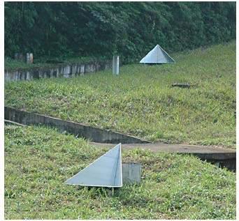
17 Ground Truth Reflectors Source: USGS

18 Ground subsidence in Bakersfield, California, (Source: USGS)

19 Ground subsidence near Lancaster, California, April 28, 1993 October 13, 1995 (Source: JPL NASA)

20
21 PART III: Implications for CSP Tower Systems? Clement Ogaja Department of Civil & Geomatics Engineering California State University, Fresno
22 Global suitability map for solar thermal power plants Flat mirror CSP Towers Photo credits: esolar, Inc
23 Sunray tracking geometry of a flat mirror CSP Tower concept
24 A relative shift in ground height of h causes sunray reflected by M' to be off target. Mirror at M has same orientation as that of mirror at M'
25 Mirror at position M' is slightly rotated to keep reflected sun ray on target at point T
26 Numerical Analysis
27 Geodetic plan view of sunray tracking geometry. All the three points are in the same geodetic plane (i.e., same longitude or meridian). 21 May 2010 SOLAR 2010 Conference, Phoenix, Arizona
28 Simulation Results
29 Summary / Recommendations The paper investigates the potential impact of crustal deformation on the CSP technology for clean electricity generation. To the author s best knowledge there is no existing program of continuous on-site monitoring of such hazards Based on the tested methodology, the findings indicate that uneven (relative) crustal deformation of magnitudes starting from as small as 0.06 m may cause the geometry of sunray reflection to be off target thus potentially compromising a CSP project Although the current findings are solely based on geometrical analysis with simulated data, it is intended that this study may form a basis for future research with actual field data. It is also probably important to gain a better mathematical insight into a parabolic field of CSP tracking mirrors.
30 Thank You!
31 Earlier Analyses: Questionable!!!
32 Earlier Analyses: Questionable!!!
CRUSTAL DYNAMICS IN CALIFORNIA: IMPLICATIONS FOR LARGE-SCALE CSP TOWER SYSTEMS
 CRUSTAL DYNAICS IN CALIFORNIA: IPLICATIONS FOR LARGE-SCALE CSP TOWER SYSTES Clement A. Ogaja, PhD Assistant Professor, Department of Civil and Geomatics Engineering California State University, Fresno
Lab 9: Satellite Geodesy (35 points)
") Lab 9: Satellite Geodesy (35 points) Here you will work with GPS Time Series data to explore plate motion and deformation in California. This lab modifies an exercise found here: http://www.unavco.org:8080/cws/pbonucleus/draftresources/sanandreas/
Lab 9: Satellite Geodesy (35 points) Here you will work with GPS Time Series data to explore plate motion and deformation in California. This lab modifies an exercise found here: http://www.unavco.org:8080/cws/pbonucleus/draftresources/sanandreas/
Exploring Plate Motion and Deformation in California with GPS
 Exploring Plate Motion and Deformation in California with GPS Cate Fox-Lent, UNAVCO Master Teacher; Andy Newman, Georgia Institute of Technology; Shelley Olds, UNAVCO; revised by Nancy West Part 1: Analyze
Radar Remote Sensing: Monitoring Ground Deformations and Geohazards from Space
 Radar Remote Sensing: Monitoring Ground Deformations and Geohazards from Space Xiaoli Ding Department of Land Surveying and Geo-Informatics The Hong Kong Polytechnic University A Question 100 km 100 km
Investigation 3: Plate Tectonics
 Investigation 3: Plate Tectonics Table of Contents Folder 1: Plate Geography and Structure... 18 Folder 2: Rates of Plate Movement... 19 Folder 3: Driving Forces... 20 Folder 4: Plate Interactions... 22
LAB: PLATE TECTONICS GOAL: Calculate rates of plate movement
 Name LAB: PLATE TECTONICS GOAL: Calculate rates of plate movement Rates of plate movement are calculated by measuring the distance rocks have moved since they formed. Rates are expressed in cm per year
GPS Strain & Earthquakes Unit 3: Finding location and velocity data for PBO GPS stations
 GPS Strain & Earthquakes Unit 3: Finding location and velocity data for PBO GPS stations Original activity by Vince Cronin (Baylor University). Revisions by Beth Pratt-Sitaula (UNAVCO). Analyzing the velocities
Pipeline Integrity Monitoring
 A Global Communications and Information Company Pipeline Integrity Monitoring is subject to the restrictions on the title page of this document. COPYRIGHT 2014 MDA 1 1 Corporate Overview Business Space-based
SCIGN science report & GPS fault slip sensors
 SCIGN science report & GPS fault slip sensors Kenneth W. Hudnut USGS, Pasadena, CA UJNR Earthquake Research Panel Meeting Morioka, Japan Nov. 6-7, 2002 GPS is now vital to earthquake monitoring (array
Investigation 5: What happens when plates move sideways past each other?
 Tectonics Investigation 5: Teacher Guide Investigation 5: What happens when plates move sideways past each other? Plates move sideways past each other at transform boundaries. At these boundaries, the
Town of Chino Valley. Survey Control Network Report. mgfneerhg mc N. Willow Creek Road Prescott AZ
 Town of Chino Valley Survey Control Network Report mgfneerhg mc. 2050 N. Willow Creek Road Prescott AZ 86301 928-771-2376 Page 1 of 70 Table of Contents Town of Chino Valley Survey Datum Outline A short
Magnitude 6.9 GULF OF CALIFORNIA
 A pair of strong earthquakes struck off the coast of Mexico early Thursday only minutes apart. The magnitude 6.9 and 6.2 were centered about 85 miles northeast of Guerrero Negro in the Mexican state of
CHAPTER 3 PROBLEM DEFINITION AND OBJECTIVE
 49 CHAPTER 3 PROBLEM DEFINITION AND OBJECTIVE 3.1 MOTIVATION Concentrating solar power is a principle of increasing solar power density. It can be demonstrated to set a piece of paper on fire by using
GPS Monitoring of the San Andreas Fault and Modeling of Slip Rate on the Mojave Section of the San Andreas Fault
 GPS Monitoring 1 GPS Monitoring of the San Andreas Fault and Modeling of Slip Rate on the Mojave Section of the San Andreas Fault By Nayeli Jimenez and Mischel Bartie PRISM Research Program Coordinator:
GPS strain analysis examples Instructor notes
 GPS strain analysis examples Instructor notes Compiled by Phil Resor (Wesleyan University) This document presents several examples of GPS station triplets for different tectonic environments. These examples
Comparison of Strain Rate Maps
 Comparison of Strain Rate Maps David T. Sandwell UNAVCO March 8, 2010 why strain rate matters comparison of 10 strain rate models new data required interseismic model velocity v(x) = V π tan 1 x D strain
GEODETIC NETWORK OF SAUDI ARABIA AND FIDUCIAL STATIONS. GFN OF Saudi Arabia in Based on ITRF2000 Datum
 STUDIES OF TECTONIC MOVEMENTS IN SAUDI ARABIA USING CORS M. Al Rajhi, Ali Al Omar, R. Yanar, F. Kartal, K. Eren, SUBJECT TO TALKS BACKGROUND GEODETIC NETWORK OF SAUDI ARABIA AND FIDUCIAL STATIONS GFN OF
Interferometric Synthetic Aperture Radar (InSAR) and GGOS. Andrea Donnellan NASA/JPL February 21, 2007
 and GGOS. Andrea Donnellan NASA/JPL February 21, 2007") Interferometric Synthetic Aperture Radar (InSAR) and GGOS Andrea Donnellan NASA/JPL February 21, 2007 Sources for Science Objectives Fourth component of EarthScope Involvement: NSF, NASA, USGS, Universities
Interferometric Synthetic Aperture Radar (InSAR) and GGOS Andrea Donnellan NASA/JPL February 21, 2007 Sources for Science Objectives Fourth component of EarthScope Involvement: NSF, NASA, USGS, Universities
Implementation of Multi-Temporal InSAR to monitor pumping induced land subsidence in Pingtung Plain, Taiwan
 Implementation of Multi-Temporal InSAR to monitor pumping induced land subsidence in Pingtung Plain, Taiwan Presenter: Oswald Advisor: Chuen-Fa Ni Date: March 09, 2017 Literature Review Pingtung Plain
CORS Network and Datum Harmonisation in the Asia-Pacific Region. Richard Stanaway and Craig Roberts
 CORS Network and Datum Harmonisation in the Asia-Pacific Region Richard Stanaway and Craig Roberts School of Surveying and Spatial Information Systems University of New South Wales CORS Networks in the
4 Survey Datums. 4.1 Horizontal Datum Policy SURVEY DATUMS SEPTEMBER 2006
 4 Survey Datums Today s multi-organizational Project Development efforts require the use of common, accurate horizontal and vertical survey datums and consistent, precise control-survey procedures to ensure
Case Study of Japan: Crustal deformation monitoring with GNSS and InSAR
 Technical Seminar Reference Frame in Practice, Case Study of Japan: Crustal deformation monitoring with GNSS and InSAR Basara Miyahara miyahara-b96ip@milt.go.jp Geospatial Information Authority of Japan
Earthquake Hazards in Douglas County
 Earthquake Hazards in Douglas County Craig M. depolo Nevada Bureau of Mines and Geology Nevada Hazard Mitigation Planning Committee August 9, 2012 Earthquake Truths The consequences of bad earthquakes
Map Skills Test. 1. What do we call a person who makes maps? a. mapographer b. cartographer c. geologist d. archaeologist
 Map Skills Test 1. What do we call a person who makes maps? a. mapographer b. cartographer c. geologist d. archaeologist 2. What is the name of the 0 latitude line? a. Equator b. Arctic Circle c. First
The EarthScope Geophysical Observatories. Slides courtesy Bob Woodward, Incorporated Research Institutions for Seismology (IRIS)
") The EarthScope Geophysical Observatories Slides courtesy Bob Woodward, Incorporated Research Institutions for Seismology (IRIS) 1 EarthScope Project Study the four dimensional structure and evolution of
The EarthScope Geophysical Observatories Slides courtesy Bob Woodward, Incorporated Research Institutions for Seismology (IRIS) 1 EarthScope Project Study the four dimensional structure and evolution of
Earthquakes and Faulting
 Earthquakes and Faulting Crustal Strength Profile Quakes happen in the strong, brittle layers Great San Francisco Earthquake April 18, 1906, 5:12 AM Quake lasted about 60 seconds San Francisco was devastated
ENGRG Introduction to GIS
 ENGRG 59910 Introduction to GIS Michael Piasecki March 17, 2014 Lecture 08: Terrain Analysis Outline: Terrain Analysis Earth Surface Representation Contour TIN Mass Points Digital Elevation Models Slope
Activity - Using GPS Data and Geologic Markers to Track Plate Motion
 Name: Date: Hour: Activity - Using GPS Data and Geologic Markers to Track Plate Motion Section Points Received Points Possible Part A Analysis 4.5 Part B Analysis 11.5 Total 16 Introduction: GPS satellites
Crustal Boundaries. As they move across the asthenosphere and form plate boundaries they interact in various ways. Convergent Transform Divergent
 Name: Date: Period: Plate Tectonics The Physical Setting: Earth Science CLASS NOTES Tectonic plates are constantly moving and interacting As they move across the asthenosphere and form plate boundaries
Lateral extrusion and tectonic escape in Ilan Plain of northeastern Taiwan
 Lateral extrusion and tectonic escape in Ilan Plain of northeastern Taiwan Angelier, J., Chang, T.Y., Hu, J.C., Chang, C.P., Siame, L., Lee, J.C., Deffontaines, B., Chu, H.T, Lu, C.Y., Does extrusion occur
Yellowstone Hotspot Component of the Plate Boundary Observatory
 Yellowstone Hotspot Component of the Plate Boundary Observatory (Investigators: Smith, Thatcher, Meertens, Humphreys, Dzurisin, Oldow Co-Investigators: Christiansen, Doss, Schwartz, Machette, Wong, Olig,
Crustal Activity. Plate Tectonics - Plates - Lithosphere - Asthenosphere - Earth s surface consists of a major plates and some minor ones
 Name: Date: Period: Tectonics The Physical Setting: Earth Science CLASS NOTES Tectonics - s - Lithosphere - Asthenosphere - Earth s surface consists of a major plates and some minor ones The plates are
Canary in the Coal Mine: Subsidence in Coastal Louisiana Press Conference
 Canary in the Coal Mine: Subsidence in Coastal Louisiana Press Conference Samuel Bentley, LSU Department of Geology & Geophysics professor and Billy and Ann Harrison chair in sedimentary geology Mead Allison,
Name. Procedure: Boundary lab. Per Date
 Name Boundary lab Per Date The vast majority of earthquakes occur at plate boundaries. The deepest earthquakes occur at subduction boundaries where lithosphere is plunging down into the mantle. Deep focus
TEGAM s Connection to the EarthScope Project
 TEGAM s Connection to the EarthScope Project Introduction The EarthScope Project is an undertaking funded by the National Science Foundation in partnership with the United States Geological Survey and
Case study of Japan: Reference Frames in Practice
 Case study of Japan: Reference Frames in Practice Basara Miyahara and Koji Matsuo Sponsors: 1 Outline Introduction - Geodetic reference frame of Japan - GEONET : continuous GNSS observation system Geometric
NAME: PERIOD: DATE: LAB PARTNERS: LAB #16 SUBDUCTION BOUNDARIES*
 NAME: PERIOD: DATE: LAB PARTNERS: LAB #16 SUBDUCTION BOUNDARIES* INTRODUCTION The vast majority of earthquakes occur at plate boundaries. The deepest earthquakes occur at subduction boundaries where lithosphere
to: Interseismic strain accumulation and the earthquake potential on the southern San
 Supplementary material to: Interseismic strain accumulation and the earthquake potential on the southern San Andreas fault system by Yuri Fialko Methods The San Bernardino-Coachella Valley segment of the
Final Report Earthquake Hazards Program Assistance Awards
 USGS Award Number(s) Final Report Earthquake Hazards Program Assistance Awards G12AP20021 and G12AP20032. Title of award Contemporary strain rates across the Yakima fold-thrust belt estimated with GPS:
DIFFERENTIAL INSAR STUDIES IN THE BOREAL FOREST ZONE IN FINLAND
 DIFFERENTIAL INSAR STUDIES IN THE BOREAL FOREST ZONE IN FINLAND Kirsi Karila (1,2), Mika Karjalainen (1), Juha Hyyppä (1) (1) Finnish Geodetic Institute, P.O. Box 15, FIN-02431 Masala, Finland, Email:
Plate Boundary Observatory the first five years
 www.earthscope.org Plate Boundary Observatory the first five years Plate Boundary Observatory A Continental-Scale, Integrated Geodetic By the Numbers (2003 2008) Installed 891 permanent Global Positioning
The financial and communal impact of a catastrophe instantiated by. volcanoes endlessly impact on lives and damage expensive infrastructure every
 Chapter 1 Introduction The financial and communal impact of a catastrophe instantiated by geophysical activity is significant. Landslides, subsidence, earthquakes and volcanoes endlessly impact on lives
Determining strain graphically
 Nancy West, Beth Pratt-Sitaula, and Shelley Olds, expanded from work by Vince Cronin, Baylor University and Anne Egger, Central Washington University. We have ample evidence that Earth deforms deformed
Measurements in the Creeping Section of the Central San Andreas Fault
 Measurements in the Creeping Section of the Central San Andreas Fault Introduction Duncan Agnew, Andy Michael We propose the PBO instrument, with GPS and borehole strainmeters, the creeping section of
Theory of Plate Tectonics
 Theory of Plate Tectonics The Theory of Plate Tectonics Plate tectonics is the theory that the Earth's lithosphere is divided into tectonic plates that move around on top of the asthenosphere. The plates
ENGRG Introduction to GIS
 ENGRG 59910 Introduction to GIS Michael Piasecki November 17, 2017 Lecture 11: Terrain Analysis Outline: Terrain Analysis Earth Surface Representation Contour TIN Mass Points Digital Elevation Models Slope
GPS Strain & Earthquakes Unit 5: 2014 South Napa earthquake GPS strain analysis student exercise
 GPS Strain & Earthquakes Unit 5: 2014 South Napa earthquake GPS strain analysis student exercise Strain Analysis Introduction Name: The earthquake cycle can be viewed as a process of slow strain accumulation
Analysis of Vertical Velocities from BARGEN Continuous GPS Data at Yucca Mountain, Southern Nevada
 Analysis of Vertical Velocities from BARGEN Continuous GPS Data at Yucca Mountain, Southern Nevada Emma Hill and Geoffrey Blewitt Nevada Bureau of Mines and Geology/178 University of Nevada, Reno Reno,
Overview of the Seismic Source Characterization for the Palo Verde Nuclear Generating Station
 Overview of the Seismic Source Characterization for the Palo Verde Nuclear Generating Station Scott Lindvall SSC TI Team Lead Palo Verde SSC SSHAC Level 3 Project Tuesday, March 19, 2013 1 Questions from
THE WILDLIFE SOCIETY CONFERENCE 2015
 THE WILDLIFE SOCIETY CONFERENCE 2015 Evaluation of Desert Tortoise Habitat Suitability Model Predictions in the Soda Mountain Area, San Bernardino County Susanne Heim Introduction Overview of Species Habitat
SONGS SSC. Tom Freeman GeoPentech PRELIMINARY RESULTS
 SONGS SSC Tom Freeman GeoPentech PRELIMINARY RESULTS Focused Questions Summarize the tectonic setting What is the seismogenic thickness? Are you including deep ruptures in the upper mantle (~30 km)? Do
Regional Geodesy. Shimon Wdowinski. MARGINS-RCL Workshop Lithospheric Rupture in the Gulf of California Salton Trough Region. University of Miami
 MARGINS-RCL Workshop Lithospheric Rupture in the Gulf of California Salton Trough Region Regional Geodesy Shimon Wdowinski University of Miami Rowena Lohman, Kim Outerbridge, Tom Rockwell, and Gina Schmalze
Comparison of 17 Strain-Rate Models from GPS Geodesy
 Comparison of 17 Strain-Rate Models from GPS Geodesy overview of 17 strain rate models fits to dense GPS and 12 models too smooth cross correlation among models and seismicity rate strain-rate tensor maps
GPS Strain & Earthquakes Unit 4: GPS strain analysis examples Student exercise
 GPS Strain & Earthquakes Unit 4: GPS strain analysis examples Student exercise Example 1: Olympic Peninsula Name: Please complete the following worksheet to estimate, calculate, and interpret the strain
2. Add the numbers in both columns of Summary Table. The total should equal the Total number of Quakes.
 Subduction lab Name Period Date The vast majority of earthquakes occur at plate boundaries. The deepest earthquakes occur at subduction boundaries where lithosphere is plunging down into the mantle. Deep
Structural deformation across the southwest Mina deflection, California-Nevada: Field studies in the Huntoon Springs area.
 Structural deformation across the southwest Mina deflection, California-Nevada: Field studies in the Huntoon Springs area. Eliya R. Hogan Advisor: Jeff Lee Introduction and purpose of study: The Mina deflection
Questions and Topics
 Plate Tectonics and Continental Drift Questions and Topics 1. What are the theories of Plate Tectonics and Continental Drift? 2. What is the evidence that Continents move? 3. What are the forces that
Climatic Change Implications for Hydrologic Systems in the Sierra Nevada
 Climatic Change Implications for Hydrologic Systems in the Sierra Nevada Part Two: The HSPF Model: Basis For Watershed Yield Calculator Part two presents an an overview of why the hydrologic yield calculator
Plate Boundary Observatory Working Group for the Central and Northern San Andreas Fault System PBO-WG-CNSA
 Plate Boundary Observatory Working Group for the Central and Northern San Andreas Fault System PBO-WG-CNSA Introduction Our proposal focuses on the San Andreas fault system in central and northern California.
John Shaw CRUSTAL DEFORMATION MODEL: OBLIQUE CONVERGENCE IN THE INNER CALIFORNIA BORDERLANDS ACCOMMODATED BY ACTIVE STRIKE-SLIP AND REVERSE FAULTS
 CRUSTAL DEFORMATION MODEL: OBLIQUE CONVERGENCE IN THE INNER CALIFORNIA BORDERLANDS ACCOMMODATED BY ACTIVE STRIKE-SLIP AND REVERSE FAULTS August 2013 SONGS SSC SSHAC Workshop # 2 (August 12-14, 2013) Crustal
Lab 1: Plate Tectonics April 2, 2009
 Name: Lab 1: Plate Tectonics April 2, 2009 Objective: Students will be introduced to the theory of plate tectonics and different styles of plate margins and interactions. Introduction The planet can be
From Earthquakes to Mountains: the Earth s Crust in Motion
 Dean s Freshman Honor Seminar (SCI 110) Eric Calais Associate Professor of Geophysics Purdue University Department of Earth and Atmospheric Sciences ecalais@purdue.edu http:/www.eas.purdue.edu/~calais
Seismic Recording Station AZ_PFO Summary Report
 Seismic Recording Station AZ_PFO Summary Report Thank you for hosting station AZ_PFO on your property. We hope that you find the enclosed report interesting. Your station is one of the 2000 USArray seismic
External Grant Award Number 01HQAG0009 WESTERN GREAT BASIN SEISMIC NETWORK OPERATIONS. December 1, 2000 to November 30, 2001
 External Grant Award Number 01HQAG0009 WESTERN GREAT BASIN SEISMIC NETWORK OPERATIONS December 1, 2000 to November 30, 2001 Glenn P. Biasi University of Nevada Reno Seismological Laboratory MS-174 Reno,
Measuring Plate Motion with GPS
 Measuring Plate Motion with GPS Student worksheet Roger Groom, Cate Fox-Lent, and Shelley Olds, UNAVCO. Revised by Nancy West and Kathleen Alexander. Under our feet is a dynamic, ever-changing Earth. Pressure
Activity Pacific Northwest Tectonic Block Model
 Activity Pacific Northwest Tectonic Block Model The Cascadia tectonic margin is caught between several tectonic forces, during the relentless motions of the giant Pacific Plate, the smaller subducting
The Four Layers The Earth is composed of four different layers. The crust is the layer that you live on, and it is the most widely studied and
 Earth s Structure The Four Layers The Earth is composed of four different layers. The crust is the layer that you live on, and it is the most widely studied and understood. The mantle is much hotter and
FORCES ON EARTH. An investigation into how Newton s Laws of Motion are applied to the tectonic activity on Earth.
 FORCES ON EARTH An investigation into how Newton s Laws of Motion are applied to the tectonic activity on Earth. GEOLOGY Geologists scientists who study the forces that make and shape the Earth Geologists
A Deformation Model to support a Next Generation Australian Geodetic Datum
 A Deformation Model to support a Next Generation Australian Geodetic Datum Richard Stanaway, Surveying and Geospatial Engineering School of Civil and Environmental Engineering multi-gnss + augmentation
GEOMATICS ENGINEERING / SURVEYING
 1 GEOMATICS ENGINEERING / SURVEYING CHAPTER 1 Dr. Muhammad Ashraf Javid Assistant Professor Department of Civil and Environmental Engineering Email: muhammad.javid@unizwa.edu.om 2 Geomatics Engineering
ACCURACY ANALYSIS OF SRTM HEIGHT MODELS INTRODUCTION
 ACCURACY ANALYSIS OF SRTM HEIGHT MODELS Ricardo Passini(*), Karsten Jacobsen(**) (*)BAE SYSTEMS 124 Gaither Dr.,Suite 100, Mount Laurel, NJ 08054, USA ricardo.passini@baesystems.com (**)Institute of Photogrammetry
ASTRONOMY. Chapter 8 EARTH AS A PLANET PowerPoint Image Slideshow
 ASTRONOMY Chapter 8 EARTH AS A PLANET PowerPoint Image Slideshow FIGURE 8.1 Active Geology. This image, taken from the International Space Station in 2006, shows a plume of ash coming from the Cleveland
InSAR results from the WInSAR Consortium
 InSAR results from the WInSAR Consortium Matt Pritchard (1); Eric Fielding (2); Shimon Wdowinski (3); Scott Baker (4); Zhong Lu (5); and 160 WInSAR Institution members (6) 1: Cornell University; 2: Jet
Physiographic Provinces (West, Ch. 13)
") Geology 229 Engineering Geology Lecture 13 Physiographic Provinces (West, Ch. 13) The definition of the term Physiography Physiography (n.) The science which treats of the earth's exterior physical features,
Geology 229 Engineering Geology Lecture 13 Physiographic Provinces (West, Ch. 13) The definition of the term Physiography Physiography (n.) The science which treats of the earth's exterior physical features,
EAS 116 Earthquakes and Volcanoes
 EAS 116 Earthquakes and Volcanoes J. Haase Forecasting Volcanic Eruptions Assessment of Volcanic Hazard Is that volcano active? Mount Lassen: 12000 BP and 1915 Santorini, IT: 180,000 BP, 70,000 BP, 21000
Image 1: Earth from space
 Image 1: Earth from space Credit: NASA Spacecraft: Apollo 17 Sensor: camera using visible light Image date: December 7, 1972 This image is a photograph of Earth taken by Harrison "Jack" Schmitt, an astronaut
USArray the first five years
 www.earthscope.org USArray the first five years USArray A Continental-Scale Seismic By the Numbers (2003 2008) More than 600 Transportable Array sites have been occupied and more than 535 permits acquired
Modern Navigation. Thomas Herring
 12.215 Modern Navigation Thomas Herring Review of Last Class Almanacs: Paper and electronics Paper Almanacs: Nautical Almanac Electronic: Available on many web sites Homework #1 solutions 10/17/2006 12.215
Contents... GIS Approach. 4D Geo-referenced Database Approach for GIS. G IS Specific GIS Applications. FIG Working Week 2004.
 FIG Working Week 2004 4D Geo-referenced Database Approach for GIS Components of GIS GIS Approach How to Produce Maps Contents... Everything is moving with Earth by Time Why 4D Geo-referenced Database Design
GEOLOGY, SOILS, AND SEISMICITY
 4.9 GEOLOGY, SOILS, AND SEISMICITY 4.9.1 Introduction Information about the geological conditions and seismic hazards in the study area was summarized in the FEIR, and was based on the Geotechnical Exploration
GPS and GIS Assisted Radar Interferometry
 GPS and GIS Assisted Radar Interferometry Linlin Ge, Xiaojing Li, Chris Rizos, and Makoto Omura Abstract Error in radar satellite orbit determination is a common problem in radar interferometry (INSAR).
Integrating NASA Space Geodetic Observations with Numerical Simulations of a Changing Earth
 Integrating NASA Space Geodetic Observations with Numerical Simulations of a Changing Earth John B. Rundle (1), Louise H. Kellogg (2), Kristy F. Tiampo (3), William Klein (4) and Paul B. Rundle (5) (1)
The Theory of Plate Tectonics
 Plate Tectonics Objectives Describe how plates move. Explain the features of plate tectonics. Describe the types of plate boundaries and the features that can form and events that can occur at each. The
Ground displacement in a fault zone in the presence of asperities
 BOLLETTINO DI GEOFISICA TEORICA ED APPLICATA VOL. 40, N. 2, pp. 95-110; JUNE 2000 Ground displacement in a fault zone in the presence of asperities S. SANTINI (1),A.PIOMBO (2) and M. DRAGONI (2) (1) Istituto
Life after Cal: Adapting to Change and Enjoying your Time in Graduate School
 Life after Cal: Adapting to Change and Enjoying your Time in Graduate School Tyler Seaman Fall 2013 http://eps.berkeley.edu/~brimhall/alumni_student_forum/website_alumni_student_forum.htm Outline! Background!
September 14, SWBAT explain how divergent boundaries shape Earth s surface.
 September 14, 2016 Aims: SWBAT explain how divergent boundaries shape Earth s surface. Agenda 1. Do Now 2. Class Notes 3. Guided Practice 4. Independent Practice 5. Practicing our AIMS: Homework: EI.11
Separating Tectonic, Magmatic, Hydrological, and Landslide Signals in GPS Measurements near Lake Tahoe, Nevada-California
 Separating Tectonic, Magmatic, Hydrological, and Landslide Signals in GPS Measurements near Lake Tahoe, Nevada-California Geoffrey Blewitt, Corné Kreemer, William C. Hammond, & Hans-Peter Plag NV Geodetic
Seismic Recording Station TA_109C Summary Report
 Seismic Recording Station TA_109C Summary Report Thank you for hosting station TA_109C on your property. We hope that you find the enclosed report interesting. Your station is one of the 2000 USArray seismic
High-resolution temporal imaging of. Howard Zebker
 High-resolution temporal imaging of crustal deformation using InSAR Howard Zebker Stanford University InSAR Prehistory SEASAT Topographic Fringes SEASAT Deformation ERS Earthquake Image Accurate imaging
Preliminary Geotechnical Observations of the July 29, 2008 Southern California Earthquake
 Preliminary Geotechnical Observations of the July 29, 2008 Southern California Earthquake Provided for: Geo-Engineering Earthquake Reconnaissance (GEER) Association Prepared by: Pirooz Kashighandi, Salih
Interpolation of 2-D Vector Data Using Constraints from Elasticity
 1 Interpolation of 2-D Vector Data Using Constraints from Elasticity David T. Sandwell Scripps Institution of Oceanography, UC San Diego, La Jolla, CA Paul Wessel SOEST, University of Hawaii at Mānoa,
Glint and Glare Analysis
 Oasis C7 CPV Tracker Glint and Glare Analysis Abstract. Assessment of potential hazards from glint and glare from concentrated solar installations is an important requirement for public safety. This paper
Today: Basic regional framework. Western U.S. setting Eastern California Shear Zone (ECSZ) 1992 Landers EQ 1999 Hector Mine EQ Fault structure
 1992 Landers EQ 1999 Hector Mine EQ Fault structure") Today: Basic regional framework Western U.S. setting Eastern California Shear Zone (ECSZ) 1992 Landers EQ 1999 Hector Mine EQ Fault structure 1 2 Mojave and Southern Basin and Range - distribution of strike-slip
Today: Basic regional framework Western U.S. setting Eastern California Shear Zone (ECSZ) 1992 Landers EQ 1999 Hector Mine EQ Fault structure 1 2 Mojave and Southern Basin and Range - distribution of strike-slip
Module 7: Plate Tectonics and Earth's Structure Topic 4 Content : Earthquakes Presentation Notes. Earthquakes
 Earthquakes 1 Topic 4 Content: Earthquakes Presentation Notes Earthquakes are vibrations within the Earth produced by the rapid release of energy from rocks that break under extreme stress. Earthquakes
Frames for the Future New Datum Definitions for Modernization of the U.S. National Spatial Reference System
 Figure 10. Horizontal position differences (in meters) between NAD 83 and ITRF 08 at time 2022.00 (January 1, 2022). Positional differences are shown for the North American and Pacific tectonic plates.
CHILEAN PART OF SIRGAS REFERENCE FRAME, REALIZATION, ADOPTION, MAINTENANCE AND ACTUAL STATUS. Geodesy for Planet Earth IAG 2009, Buenos Aires
 CHILEAN PART OF SIRGAS REFERENCE FRAME, REALIZATION, ADOPTION, MAINTENANCE AND ACTUAL STATUS Geodesy for Planet Earth IAG 2009, Buenos Aires Ing. Héctor Parra hparra@igm.cl, IGM Chile Dr. Juan Báez jbaez@udec.cl,
Interpretive Map Series 24
 Oregon Department of Geology and Mineral Industries Interpretive Map Series 24 Geologic Hazards, Earthquake and Landslide Hazard Maps, and Future Earthquake Damage Estimates for Six Counties in the Mid/Southern
EXPLORE PLATE TECTONICS & MORE THROUGH GPS DATA. Shelley Olds, UNAVCO April 12, 2018 NGSS Webinar
 EXPLORE PLATE TECTONICS & MORE THROUGH GPS DATA Shelley Olds, UNAVCO April 12, 2018 NGSS Webinar Today s Outline Central question: How do we know the tectonic plates are still moving? -- What evidence
International boundaries on a dynamic planet issues relating to plate tectonics and reference frame changes
 International boundaries on a dynamic planet issues relating to plate tectonics and reference frame changes Presented at the FIG Working Week 2017, May 29 - June 2, 2017 in Helsinki, Finland D Grant (RMIT
Slip Sliding Along. Materials Per Group (groups of 4)
") Slip Sliding Along Lesson Concept Link California has a strike-slip fault (San Andreas) on the transform boundary between the Pacific and North American Plate. Lesson 6.4 deepened understanding of types
Slip Sliding Along Lesson Concept Link California has a strike-slip fault (San Andreas) on the transform boundary between the Pacific and North American Plate. Lesson 6.4 deepened understanding of types