Comparison of 17 Strain-Rate Models from GPS Geodesy
|
|
|
- Letitia Cross
- 5 years ago
- Views:
Transcription
1 Comparison of 17 Strain-Rate Models from GPS Geodesy overview of 17 strain rate models fits to dense GPS and 12 models too smooth cross correlation among models and seismicity rate strain-rate tensor maps why GPS alone cannot uniquely map strain rate strain-rate from new InSAR satellites
2 Comparison of Strain-Rate Maps of Western North America Thorsten Becker, University of Southern California Peter Bird, University of California at Los Angeles Jayne Bormann and Bill Hammond, UNR Andrew Freed, Purdue University Matthias Hackl, LMU, Munich, Germany Brendan Meade and Jack Loveless, Harvard William Holt, State University of New York, Stony Brook Ben Hooks, University of Texas at El Paso Sharon Kedar, Sean Baxter, JPL Corne Kreemer, University of Nevada Rob McCaffrey, Rensselaer Polytechnic Institute Tom Parsons, USGS Fred Pollitz, USGS Menlo Park Zeng-Kang Shen, UCLA Bridget Smith-Konter, University of Texas at El Paso Carl Tape, Harvard Yuehua Zeng, USGS
3 Velocity to Strain Rate v i v i k k ( x j ) ± σ i i = 1, 2, 3 j = 1, 2 k = 1 N ( x j ) - vector velocity at point k 2-D interpolation and/or dislocation model - surface vector velocity (0.01 ) principal strain rate ε 1,2 = ε xx + ε yy 2 ± 1 2 ( ε xx ε yy ) ε xy { } 1/2 dilatation + maximum shear rate rate ε ij = 1 & 2 ( ' differentiation (GMT grdgradient) v i x j + v j x i ) + * - 2D strain rate second invariant ( ) 1/2 ε II = ε 2 xx + ε ε 2 yy xy
4 Median Spacing of GPS Stations [Wei et al. 2010]
5 Different Methods and Assumptions to Overcome Incomplete Spatial Sampling Four approaches are used: 1) isotropic interpolation; 2) interpolation guided by known faults; 3) interpolation of a rheologically-layered lithosphere, and 4) model fitting using deep dislocations in an elastic layer or half space.
6 Jayne Bormann and Bill Hammond sent two velocity fields on a uniform grid constructed from their test exercise using CMM4. Hammond s code was used. Surface creep was not included and a uniform locking depth of 15 km was used. 091 ηs
 for Pacific Northwest, the GPS velocity field of Nevada and its surrounding area from the Nevada Geodetic Lab at the University of Nevada at Reno, and the GPS velocity field of the")
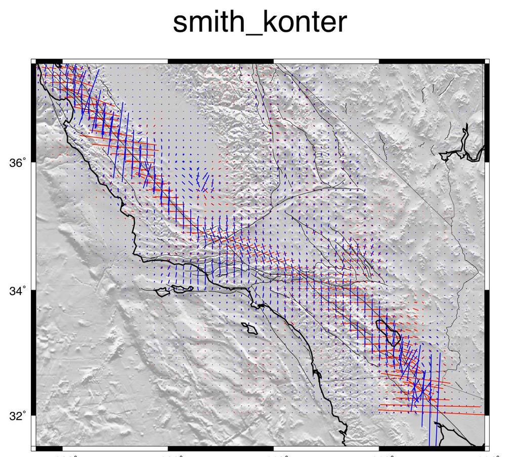
7 095 ηs The GPS data for the western US are obtained from PBO velocity at UNAVCO site, Southern California Earthquake Center California Crustal Motion Map 1.0, McCaffrey et al. (2007) for Pacific Northwest, the GPS velocity field of Nevada and its surrounding area from the Nevada Geodetic Lab at the University of Nevada at Reno, and the GPS velocity field of the Wasatch-Front and the Yellowstone-Snake-River-River-Plain network from Bob Smith of University of Utah. These separate velocity fields are combined by adjusting their reference frames to make velocities match at collocated stations. I determined the Voronoi cells for this combined GPS stations and used their areas to weight the corresponding stations for inversion. I then interpolated those GPS observation into uniform grid point for the western US using the method of Wald (1998) and calculated the final strain rate map. A A' B B' C' C

8 111 ηs What I do is use an anisotropic variance-covariance matrix for the strain rates. I do not build in fault slip rates, but I use the variancecovariance matrix to place a priori constraints on expected shear directions as well as some constraints on expected shear magntitudes. However, in the end the GPS velocities dictate the actual strain rates and styles of strain rate (where they are high, low, etc.). I am also limited by the finite-element grid, which is.1x.1 degree grid area spacing. It might be worthwhile to compare the solution I sent you with one obtained using fully isotropic uniform variances for all areas. That is, with an a priori expected strain rate distribution that is everywhere uniform. I can look into the reduced chi-squared misfit for both of these cases.
![Strain rate derived from a dislocation model of the San Andreas Fault system [Smith-Konter and Sandwell, GRL, 2009]. 610 GPS velocity vectors were used to develop the model.](/docs-images/90/101811290/images/9-0.jpg "The model consists of an elastic plate over a visco-elastic half space at 1 km horizontal resolution. Deep slip occurs on 41 major fault segments where rate is largely derived from geological studies.")
9 Strain rate derived from a dislocation model of the San Andreas Fault system [Smith-Konter and Sandwell, GRL, 2009]. 610 GPS velocity vectors were used to develop the model. The model consists of an elastic plate over a visco-elastic half space at 1 km horizontal resolution. Deep slip occurs on 41 major fault segments where rate is largely derived from geological studies. The locking depth is varied along each fault segment to provide a best fit to the GPS data. The model is fully 3-D and the vertical component of the GPS vectors is also used in the adjustment. An additional velocity model was developed by gridding the residuals to the GPS data using the GMT surface program with a tension of This was added to the dislocation model. 123 ηs
![Strain rate tensor model derived from fitting a continuous horizontal velocity field through GPS velocities [Kreemer et al, 2009].](/docs-images/90/101811290/images/10-0.jpg "2053 GPS velocities were used, of which 854 from our own analysis of (semi-)continuous sites and 1199 from published campaign measurements (all transformed into the same reference frame).")
10 Strain rate tensor model derived from fitting a continuous horizontal velocity field through GPS velocities [Kreemer et al, 2009] GPS velocities were used, of which 854 from our own analysis of (semi-)continuous sites and 1199 from published campaign measurements (all transformed into the same reference frame). The model assumes that the deformation is accommodated continuously, and lateral variation in damping is applied to ensure that the reduced chi^2 fit between observed and modeled velocities is ~1.0 for subregions. 114 ηs
11 Comparison of 17 Strain-Rate Models from GPS Geodesy overview of 17 strain rate models fits to dense GPS and 12 models too smooth cross correlation among models and seismicity rate strain-rate tensor maps why GPS alone cannot uniquely map strain rate strain-rate from new InSAR satellites
12 Imperial array High density campaign GPS measurements across the Imperial fault provide the data needed to estimate the strain rate [Lyons et al., 2002]. The best-fit 2-D dislocation model has a velocity V o of 40 mm/yr and a locking depth D of 6 km (upper plot). The derivative of this velocity profile provides the shear strain rate (lower plot). The peak strain rate is given by ε = V π D which in this case has a value of 2120 nanostrain/yr. ( ) = V # x π tan 1 v x ε ( x) = V & $ % D' ( 1 π D # 1 + x & $ % D' ( 2
13 Carrizo GPS data Earthquake Cycle Exercise, April, Participants were given a GPS velocity profile, that is, the faultparallel velocity, one-sigma error, and distance to the fault for 64 GPS sites (Figure 10). The data were from the San Andreas Fault at the Carrizo Plain, though this was not mentioned in the exercise. Participants were asked to devise models that could explain the velocity profile. Elastic dislocation models, including those with a dipping fault and elastic heterogeneities, gave a slip rate of 33 to 35 mm/yr and a locking depth of 17 to 19 km. Using V=35 and D=17 and the peak strain rate is 790 nanostrain/yr. Vo (mm/yr) ( ) = V # x! tan"1 v x elastic viscoelastic believable viscoelastic & % $ D ( ' viscoelastic with fault creep believable vi scoelastic with fault creep (36-40) (35-40) Zl (km) to (20-25) (10) stress rate (kpa/yr)
14 Strain rate profiles from all 17 models. Comapred with best-fit 2-D Savage model 12 of the 17 models have unrealistic low strain rate above the fault which results in unrealistic high strain rate away from faults.
15 Strain rate profiles from 5 best models. Comapred with best-fit 2-D Savage model
16 Comparison of 17 Strain-Rate Models from GPS Geodesy overview of 17 strain rate models fits to dense GPS and 12 models too smooth cross correlation among models and seismicity rate strain-rate tensor maps why GPS alone cannot uniquely map strain rate strain-rate from new InSAR satellites
17 average of 5 best models SEISM_strain = 10 rate+5.3
18 average of 5 best models std of 5 best models
19 Comparison of 17 Strain-Rate Models from GPS Geodesy overview of 17 strain rate models fits to dense GPS and 12 models too smooth cross correlation among models and seismicity rate strain-rate tensor maps why GPS alone cannot uniquely map strain rate strain-rate from new InSAR satellites
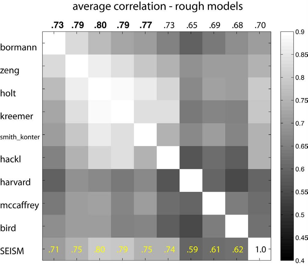
20 Overall Results UCERF2 SEISM SHmax (rms ) Rank borman holt kreemer smith_konter zeng !
21 Comparison of 17 Strain-Rate Models from GPS Geodesy overview of 17 strain rate models fits to dense GPS and 8 models too smooth cross correlation among models and seismicity rate strain-rate tensor maps why GPS alone cannot uniquely map strain rate strain-rate from new InSAR satellites


22 Median Spacing of GPS Stations [Wei et al. 2010]
23 Coherence Spectrum of the 4 Block Models " GPS model are coherent at wavelength > 40 km " Due to the spacing of the GPS sites 23 BSL 2012 Tong c) averaged coherence spectrum wavenumber (1/km) coherence 40 km
24 Comparison of 17 Strain-Rate Models from GPS Geodesy overview of 17 strain rate models fits to dense GPS and 12 models too smooth cross correlation among models and seismicity rate strain-rate tensor maps why GPS alone cannot uniquely map strain rate strain-rate from new InSAR satellites


25 New Missions Sentinel-1A (ESA) was successfully April 3, 2014, SAR collecting data! C-band, 12-day repeat Mostly ScanSAR coverage of the SAF, ascending and descending completely open data access finally!! Sentinel-1B to be launched 2016 and will provide 6-day repeat interval ALOS-2 (JAXA) was successfully launched May 24, 2014, SAR collecting data! L-band, 14-day repeat Mostly ScanSAR coverage of the SAF on descending and swath-mode on ascending PI proposal needed for data access limited quantities per PI

26 Coverage of the San Andreas Fault System from Sentinel-1 Today each frame has 15 repeats on a 24-day cadence. Each interferogram is 250 km by 200 km.

27 Coverage of the San Andreas Fault System from ALOS-2 Today each frame has 9 repeats on a 42-day cadence. Each ALOS-2 interogram is 350 km by 350 km

28 Example interferograms from ALOS-2 and Sentinel-1A. New processing methods are needed to achieve seamless coverage. Large trends in ALOS-2 InSAR may reflect spatial variations in ionosphere TEC.
29 Expected velocity error from Sentinel-1a observations at 12-day intervals. Assumes atmospheric error model of Emardson et al., [2003]. 1 mm/yr accuracy can be achieved in 3 years for areas with ~20 km GPS spacing. 250 nanostrain over at 1 km resolution can be achieved in 3 years. (Tim Wright, personal communication, 2015) 8+'9:;(,<$=+(&)(&>,+#?$%&'(.@*0( 123( 3( 4( 5( 6( 7(!"#$%&'(&)(%*+(,+#-+,(./+$#,0(
30 Conclusions The current GPS sampling of ~8 km is insufficient for unique recoverly of strain rate. Need a fault model to localize strain and provide direction. The 5 best models are similar to each other and to the log of the seismicity rate. New InSAR satellites will deliver 1 km spatial resolution strain rate maps accurate to 250 nanostrain/yr. Then we won t need fault models to guide the interpolation.
.")
31 The background seismicity model is included to account for M earthquakes on faults and for random M earthquakes that do not occur on faults included in the model (as in earlier models of Frankel et al., 1996, 2002 and Petersen et al., 1996). We include four different classes of earthquake sources in the California background seismicity model: (1) gridded (smoothed) seismicity, (2) regional background zones, (3) special fault zone models, and (4) shear zones (also referred to as C zones). The gridded (smoothed) seismicity model, the regional background zone model, and the special fault zones use a declustered earthquake catalog for calculation of earthquake rates. Earthquake rates in shear zones are estimated from the geodetically determined rate of deformation across an area of high strain rate. We use a truncated exponential (Gutenberg-Richter, 1944) magnitudefrequency distribution to account for earthquakes in the background models.
32
33
34
35
36
37
38 091 ηs blue SHmax green - comp
39 095 ηs blue SHmax green - comp B' B C C'

40 111 ηs blue SHmax green - comp
41 123 ηs blue SHmax green - comp
42 114 ηs blue SHmax green - comp
Comparison of Strain Rate Maps
 Comparison of Strain Rate Maps David T. Sandwell UNAVCO March 8, 2010 why strain rate matters comparison of 10 strain rate models new data required interseismic model velocity v(x) = V π tan 1 x D strain
The SCEC Community Geodetic Model V1: Horizontal Velocity Grid
 The SCEC Community Geodetic Model V1: Horizontal Velocity Grid David T. Sandwell Yuehua Zeng Zheng-Kang Shen Brendan Crowell Jessica Murray Rob McCaffrey Xiaohua Xu Draft V2: October 17, 2016 Abstract
Jack Loveless Department of Geosciences Smith College
 Geodetic constraints on fault interactions and stressing rates in southern California Jack Loveless Department of Geosciences Smith College jloveless@smith.edu Brendan Meade Department of Earth & Planetary
Interpolation of 2-D Vector Data Using Constraints from Elasticity
 1 Interpolation of 2-D Vector Data Using Constraints from Elasticity David T. Sandwell Scripps Institution of Oceanography, UC San Diego, La Jolla, CA Paul Wessel SOEST, University of Hawaii at Mānoa,
Stress modulation on the San Andreas fault by interseismic fault system interactions Jack Loveless and Brendan Meade, Geology, 2011
 Stress modulation on the San Andreas fault by interseismic fault system interactions Jack Loveless and Brendan Meade, Geology, 2011 A three step process: 1 - Assimilate plate boundary wide GPS data into
Regional Geodesy. Shimon Wdowinski. MARGINS-RCL Workshop Lithospheric Rupture in the Gulf of California Salton Trough Region. University of Miami
 MARGINS-RCL Workshop Lithospheric Rupture in the Gulf of California Salton Trough Region Regional Geodesy Shimon Wdowinski University of Miami Rowena Lohman, Kim Outerbridge, Tom Rockwell, and Gina Schmalze
Kinematics of the Southern California Fault System Constrained by GPS Measurements
 Title Page Kinematics of the Southern California Fault System Constrained by GPS Measurements Brendan Meade and Bradford Hager Three basic questions Large historical earthquakes One basic question How
Regional deformation and kinematics from GPS data
 Regional deformation and kinematics from GPS data Jessica Murray, Jerry Svarc, Elizabeth Hearn, and Wayne Thatcher U. S. Geological Survey Acknowledgements: Rob McCaffrey, Portland State University UCERF3
Estimating fault slip rates, locking distribution, elastic/viscous properites of lithosphere/asthenosphere. Kaj M. Johnson Indiana University
 3D Viscoelastic Earthquake Cycle Models Estimating fault slip rates, locking distribution, elastic/viscous properites of lithosphere/asthenosphere Kaj M. Johnson Indiana University In collaboration with:
to: Interseismic strain accumulation and the earthquake potential on the southern San
 Supplementary material to: Interseismic strain accumulation and the earthquake potential on the southern San Andreas fault system by Yuri Fialko Methods The San Bernardino-Coachella Valley segment of the
The 3 rd SCEC CSM workshop
 The 3 rd SCEC CSM workshop Welcome on behalf of the organizers Jeanne Hardebeck Brad Aagaard David Sandwell Bruce Shaw John Shaw Thorsten Becker Thanks for playing! SCEC Community Stress Model (CSM) Community
Lab 9: Satellite Geodesy (35 points)
") Lab 9: Satellite Geodesy (35 points) Here you will work with GPS Time Series data to explore plate motion and deformation in California. This lab modifies an exercise found here: http://www.unavco.org:8080/cws/pbonucleus/draftresources/sanandreas/
Lab 9: Satellite Geodesy (35 points) Here you will work with GPS Time Series data to explore plate motion and deformation in California. This lab modifies an exercise found here: http://www.unavco.org:8080/cws/pbonucleus/draftresources/sanandreas/
Lecture 14: Strain Examples. GEOS 655 Tectonic Geodesy Jeff Freymueller
 Lecture 14: Strain Examples GEOS 655 Tectonic Geodesy Jeff Freymueller A Worked Example Consider this case of pure shear deformation, and two vectors dx 1 and dx 2. How do they rotate? We ll look at vector
Summary so far. Geological structures Earthquakes and their mechanisms Continuous versus block-like behavior Link with dynamics?
 Summary so far Geodetic measurements velocities velocity gradient tensor (spatial derivatives of velocity) Velocity gradient tensor = strain rate (sym.) + rotation rate (antisym.) Strain rate tensor can
Basics of the modelling of the ground deformations produced by an earthquake. EO Summer School 2014 Frascati August 13 Pierre Briole
 Basics of the modelling of the ground deformations produced by an earthquake EO Summer School 2014 Frascati August 13 Pierre Briole Content Earthquakes and faults Examples of SAR interferograms of earthquakes
Slip rates and off-fault deformation in Southern California inferred from GPS data and models
 JOURNAL OF GEOPHYSICAL RESEARCH: SOLID EARTH, VOL. 8, 6 66, doi:./jgrb.6, Slip rates and off-fault deformation in Southern California inferred from GPS data and models K. M. Johnson Received 9 December
Geodetic observations of transient deformation in Southern California
 Geodetic observations of transient deformation in Southern California How do we determine which ones are real? EarthScope Institute on the Spectrum of Fault Slip Portland, Oregon. October 11-14, 2010 Detecting
Elizabeth H. Hearn modified from W. Behr
 Reconciling postseismic and interseismic surface deformation around strike-slip faults: Earthquake-cycle models with finite ruptures and viscous shear zones Elizabeth H. Hearn hearn.liz@gmail.com modified
Separating Tectonic, Magmatic, Hydrological, and Landslide Signals in GPS Measurements near Lake Tahoe, Nevada-California
 Separating Tectonic, Magmatic, Hydrological, and Landslide Signals in GPS Measurements near Lake Tahoe, Nevada-California Geoffrey Blewitt, Corné Kreemer, William C. Hammond, & Hans-Peter Plag NV Geodetic
Ground displacement in a fault zone in the presence of asperities
 BOLLETTINO DI GEOFISICA TEORICA ED APPLICATA VOL. 40, N. 2, pp. 95-110; JUNE 2000 Ground displacement in a fault zone in the presence of asperities S. SANTINI (1),A.PIOMBO (2) and M. DRAGONI (2) (1) Istituto
Appendix O: Gridded Seismicity Sources
 Appendix O: Gridded Seismicity Sources Peter M. Powers U.S. Geological Survey Introduction The Uniform California Earthquake Rupture Forecast, Version 3 (UCERF3) is a forecast of earthquakes that fall
Measurements in the Creeping Section of the Central San Andreas Fault
 Measurements in the Creeping Section of the Central San Andreas Fault Introduction Duncan Agnew, Andy Michael We propose the PBO instrument, with GPS and borehole strainmeters, the creeping section of
Introduction to Strain and Borehole Strainmeter Data
 Introduction to Strain and Borehole Strainmeter Data Evelyn Roeloffs U. S. Geological Survey Earthquake Science Center March 28, 2016 Evelyn Roeloffs, USGS ESC Strainmeters: Introduction March 28, 2016
A new era of geodetic big data - challenges and opportunities Tim Wright (COMET, University of
 A new era of geodetic big data - challenges and opportunities Tim Wright (COMET, University of Leeds) S @NERC_COMET N A New Era of Geodetic Big Data? GEM Strain Rate Model 17,491 GNSS sites included in
Geophysical Journal International
 Geophysical Journal International Geophys. J. Int. (215) 23, 48 62 GJI Seismology doi: 1.193/gji/ggv269 An integral method to estimate the moment accumulation rate on the Creeping Section of the San Andreas
Syllabus and Course Description Geophysical Geodesy Fall 2013 GPH 411/611
 Syllabus and Course Description Geophysical Geodesy Fall 2013 GPH 411/611 Course Location: LME 422 Course Time: Tuesday & Thursday 12:00-1:15 Units: 3 Instructor Name: Bill Hammond Office Location: SEM
Constraints on Intra-Continental Strain Rates and Glacial Isostatic Adjustment from Thousands of GPS Velocities
 Constraints on Intra-Continental Strain Rates and Glacial Isostatic Adjustment from Thousands of GPS Velocities Corné Kreemer William Hammond & Geoffrey Blewitt Nevada Geodetic Laboratory, NV Bureau of
GEORED Project: GNSS Geodesy Network for Geodynamics Research in Colombia, South America. Héctor Mora-Páez
 GEORED Project: GNSS Geodesy Network for Geodynamics Research in Colombia, South America. Héctor Mora-Páez Colombian Geological Survey UNAVCO SCIENCE MEETING Feb 27 March 1, 2012 Boulder, CO, TECTONIC
The March 11, 2011, Tohoku-oki earthquake (Japan): surface displacement and source modelling
: surface displacement and source modelling") The March 11, 2011, Tohoku-oki earthquake (Japan): surface displacement and source modelling Salvatore Stramondo Bignami C., Borgstrom S., Chini M., Guglielmino F., Melini D., Puglisi G., Siniscalchi V.,
The March 11, 2011, Tohoku-oki earthquake (Japan): surface displacement and source modelling Salvatore Stramondo Bignami C., Borgstrom S., Chini M., Guglielmino F., Melini D., Puglisi G., Siniscalchi V.,
GPS Strain & Earthquakes Unit 4: GPS strain analysis examples Student exercise
 GPS Strain & Earthquakes Unit 4: GPS strain analysis examples Student exercise Example 1: Olympic Peninsula Name: Please complete the following worksheet to estimate, calculate, and interpret the strain
Exploring the Relationship between Geothermal Resources and Geodetically Inferred Faults Slip Rates in the Great Basin
 Exploring the Relationship between Geothermal Resources and Geodetically Inferred Faults Slip Rates in the Great Basin William C. Hammond, Corné Kreemer, Geoff Blewitt Nevada Bureau of Mines and Geology
Targeting of Potential Geothermal Resources in the Great Basin from Regional Relationships between Geodetic Strain and Geological Structures
 Targeting of Potential Geothermal Resources in the Great Basin from Regional Relationships between Geodetic Strain and Geological Structures Geoffrey Blewitt and Mark Coolbaugh Great Basin Center for Geothermal
Stress equilibrium in southern California from Maxwell stress function models fit to both earthquake data and a quasi-static dynamic simulation
 Stress equilibrium in southern California from Maxwell stress function models fit to both earthquake data and a quasi-static dynamic simulation Peter Bird Dept. of Earth, Planetary, and Space Sciences
GPS strain analysis examples Instructor notes
 GPS strain analysis examples Instructor notes Compiled by Phil Resor (Wesleyan University) This document presents several examples of GPS station triplets for different tectonic environments. These examples
Journal of Geophysical Research Letters Supporting Information for
 Journal of Geophysical Research Letters Supporting Information for InSAR observations of strain accumulation and fault creep along the Chaman Fault system, Pakistan and Afghanistan H. Fattahi 1, F. Amelung
Earthquakes and Faulting
 Earthquakes and Faulting Crustal Strength Profile Quakes happen in the strong, brittle layers Great San Francisco Earthquake April 18, 1906, 5:12 AM Quake lasted about 60 seconds San Francisco was devastated
Okada, 1985, Text
 Okada, 19, 1992 Buried dislocation Elastic half-space Relates slip on patch to 3d displacements at surface Differs from seismology where source is infinitesimal Text Strike Slip From Segall, 2 Dip Slip
DEFORMATION KINEMATICS OF TIBETAN PLATEAU DETERMINED FROM GPS OBSERVATIONS
 DEFORMATION KINEMATICS OF TIBETAN PLATEAU DETERMINED FROM GPS OBSERVATIONS Jinwei Ren Institute of Geology, China Seismological Bureau, Beijing 100029 China Tel: (10)62009095; Fax: (10)62009003; email:
GPS Strain & Earthquakes Unit 5: 2014 South Napa earthquake GPS strain analysis student exercise
 GPS Strain & Earthquakes Unit 5: 2014 South Napa earthquake GPS strain analysis student exercise Strain Analysis Introduction Name: The earthquake cycle can be viewed as a process of slow strain accumulation
Power-law distribution of fault slip-rates in southern California
 Click Here for Full Article GEOPHYSICAL RESEARCH LETTERS, VOL. 34, L23307, doi:10.1029/2007gl031454, 2007 Power-law distribution of fault slip-rates in southern California Brendan J. Meade 1 Received 31
Exploring Plate Motion and Deformation in California with GPS
 Exploring Plate Motion and Deformation in California with GPS Cate Fox-Lent, UNAVCO Master Teacher; Andy Newman, Georgia Institute of Technology; Shelley Olds, UNAVCO; revised by Nancy West Part 1: Analyze
Plate Boundary Observatory Working Group for the Central and Northern San Andreas Fault System PBO-WG-CNSA
 Plate Boundary Observatory Working Group for the Central and Northern San Andreas Fault System PBO-WG-CNSA Introduction Our proposal focuses on the San Andreas fault system in central and northern California.
Introduction to Displacement Modeling
 Introduction to Displacement Modeling Introduction Deformation on the Earth surface informs us about processes and material properties below surface Observation tools: GPS (static-dynamic) InSAR (static)
INGV. Giuseppe Pezzo. Istituto Nazionale di Geofisica e Vulcanologia, CNT, Roma. Sessione 1.1: Terremoti e le loro faglie
 Giuseppe Pezzo Istituto Nazionale di Geofisica e Vulcanologia, CNT, Roma giuseppe.pezzo@ingv.it The study of surface deformation is one of the most important topics to improve the knowledge of the deep
Today: Basic regional framework. Western U.S. setting Eastern California Shear Zone (ECSZ) 1992 Landers EQ 1999 Hector Mine EQ Fault structure
 1992 Landers EQ 1999 Hector Mine EQ Fault structure") Today: Basic regional framework Western U.S. setting Eastern California Shear Zone (ECSZ) 1992 Landers EQ 1999 Hector Mine EQ Fault structure 1 2 Mojave and Southern Basin and Range - distribution of strike-slip
Today: Basic regional framework Western U.S. setting Eastern California Shear Zone (ECSZ) 1992 Landers EQ 1999 Hector Mine EQ Fault structure 1 2 Mojave and Southern Basin and Range - distribution of strike-slip
Exploring the Relationship between Geothermal Resources and Geodetically Inferred Faults Slip Rates in the Great Basin
 GRC Transactions, Vol. 31, 2007 Exploring the Relationship between Geothermal Resources and Geodetically Inferred Faults Slip Rates in the Great Basin William C. Hammond, Corné Kreemer, and Geoff Blewitt
The Earth s time-variable gravity field observed by GOCE
 The Earth s time-variable gravity field observed by GOCE GOCE+ Time-Variations, part of STSE (Theme 4, Innovative Feasibility Studies) J. Bouman, M. Fuchs, C. Haberkorn, V. Lieb, M. Schmidt T. Broerse,
Geodynamics Lecture 5 Basics of elasticity
 Geodynamics Lecture 5 Basics of elasticity Lecturer: David Whipp david.whipp@helsinki.fi! 16.9.2014 Geodynamics www.helsinki.fi/yliopisto 1 Goals of this lecture Introduce linear elasticity! Look at the
Supplementary Material
 1 Supplementary Material 2 3 4 Interseismic, megathrust earthquakes and seismic swarms along the Chilean subduction zone (38-18 S) 5 6 7 8 9 11 12 13 14 1 GPS data set We combined in a single data set
Buried Strike Slip Faults: The 1994 and 2004 Al Hoceima, Morocco Earthquakes.
 Buried Strike Slip Faults: The 1994 and 2004 Al Hoceima, Morocco Earthquakes. Juliet Biggs 1, Eric Bergman 2, Brian Emmerson 3, Gareth Funning 4, James Jackson 3, Barry Parsons 1,Tim Wright 1. 1 COMET,
Case Study 1: 2014 Chiang Rai Sequence
 Case Study 1: 2014 Chiang Rai Sequence Overview Mw 6.1 earthquake on 5 May 2014 at 11:08:43 UTC Largest recorded earthquake in Thailand Fault Orientation How does the orientation of the fault affect the
The problem (1/2) GPS velocity fields in plate boundary zones are very smooth. What does this smoothness hide?
 GPS velocity fields in plate boundary zones are very smooth. What does this smoothness hide?") Block models The problem (1/2) GPS velocity fields in plate boundary zones are very smooth Figure from Tom Herring, MIT What does this smoothness hide? Continuous deformation? Rigid block motions, with
Block models The problem (1/2) GPS velocity fields in plate boundary zones are very smooth Figure from Tom Herring, MIT What does this smoothness hide? Continuous deformation? Rigid block motions, with
Overview of the Seismic Source Characterization for the Palo Verde Nuclear Generating Station
 Overview of the Seismic Source Characterization for the Palo Verde Nuclear Generating Station Scott Lindvall SSC TI Team Lead Palo Verde SSC SSHAC Level 3 Project Tuesday, March 19, 2013 1 Questions from
Initiation of the San Jacinto Fault and its Interaction with the San Andreas Fault: Insights from Geodynamic Modeling
 Pure appl. geophys. (2007) DOI 10.1007/s00024-007-0262-z Ó Birkhäuser Verlag, Basel, 2007 Pure and Applied Geophysics Initiation of the San Jacinto Fault and its Interaction with the San Andreas Fault:
GPS Monitoring of the San Andreas Fault and Modeling of Slip Rate on the Mojave Section of the San Andreas Fault
 GPS Monitoring 1 GPS Monitoring of the San Andreas Fault and Modeling of Slip Rate on the Mojave Section of the San Andreas Fault By Nayeli Jimenez and Mischel Bartie PRISM Research Program Coordinator:
Yellowstone Hotspot Component of the Plate Boundary Observatory
 Yellowstone Hotspot Component of the Plate Boundary Observatory (Investigators: Smith, Thatcher, Meertens, Humphreys, Dzurisin, Oldow Co-Investigators: Christiansen, Doss, Schwartz, Machette, Wong, Olig,
A Fault-Based Model for Crustal Deformation, Fault Slip Rates, and Off-Fault Strain Rate in California
 Bulletin of the Seismological Society of America, Vol. 106, No. 2, pp., April 2016, doi: 10.1785/0120140250 E A Fault-Based Model for Crustal Deformation, Fault Slip Rates, and Off-Fault Strain Rate in
CRUSTAL DYNAMICS IN CALIFORNIA: IMPLICATIONS FOR LARGE-SCALE CSP TOWER SYSTEMS
 CRUSTAL DYNAMICS IN CALIFORNIA: IMPLICATIONS FOR LARGE-SCALE CSP TOWER SYSTEMS Clement Ogaja Department of Civil & Geomatics Engineering California State University, Fresno Introduction Clement Ogaja Department
Earthquake Hazards in Douglas County
 Earthquake Hazards in Douglas County Craig M. depolo Nevada Bureau of Mines and Geology Nevada Hazard Mitigation Planning Committee August 9, 2012 Earthquake Truths The consequences of bad earthquakes
Christine M. Puskas. Objective: A geophysical position where a background in geophysical modeling, data processing, and GPS studies can be applied.
 Christine M. Puskas 777 E South Temple 9C Salt Lake City, UT 84102 www.uusatrg.utah.edu/people/christine (801) 581-7856 Office (801) 521-4107 Home c.puskas@utah.edu Education Ph.D. in Geophysics, University
The San Andreas Fault Observatory at Depth: Recent Site Characterization Studies and the 2.2-Km-Deep Pilot Hole
 The San Andreas Fault Observatory at Depth: Recent Site Characterization Studies and the 2.2-Km-Deep Pilot Hole Steve Hickman and Bill Ellsworth (USGS) Mark Zoback (Stanford University) and the Pre-EarthScope
Geodetic slip rates in the southern San Andreas Fault system: Effects of elastic heterogeneity and fault geometry
 JOURNAL OF GEOPHYSICAL RESEARCH: SOLID EARTH, VOL. 118, 689 697, doi:10.1029/2012jb009358, 2013 Geodetic slip rates in the southern San Andreas Fault system: Effects of elastic heterogeneity and fault
Rheology III. Ideal materials Laboratory tests Power-law creep The strength of the lithosphere The role of micromechanical defects in power-law creep
 Rheology III Ideal materials Laboratory tests Power-law creep The strength of the lithosphere The role of micromechanical defects in power-law creep Ideal materials fall into one of the following categories:
Basic Concepts of Strain and Tilt. Evelyn Roeloffs, USGS June 2008
 Basic Concepts of Strain and Tilt Evelyn Roeloffs, USGS June 2008 1 Coordinates Right-handed coordinate system, with positions along the three axes specified by x,y,z. x,y will usually be horizontal, and
Crustal Deformation Earth - Chapter Pearson Education, Inc.
 Crustal Deformation Earth - Chapter 10 Structural Geology Structural geologists study the architecture and processes responsible for deformation of Earth s crust. A working knowledge of rock structures
} based on composition
 Learning goals: Predict types of earthquakes that will happen at different plate boundaries based on relative plate motion vector vs. strike (vector subtraction) Understand interseismic and coseismic deformation,
27th Seismic Research Review: Ground-Based Nuclear Explosion Monitoring Technologies
 GROUND TRUTH OF AFRICAN AND EASTERN MEDITERRANEAN SHALLOW SEISMICITY USING SAR INTERFEROMETRY AND GIBBS SAMPLING INVERSION Benjamin A. Brooks 1, Francisco Gomez 2, Eric A. Sandvol 2, and Neil Frazer 1
Publisher: GSA Journal: GEOL: Geology Article ID: G Pacific plate deformation from horizontal thermal contraction
 1 Pacific plate deformation from horizontal thermal contraction 2 Corné Kreemer 1 and Richard G. Gordon 2 1 Nevada Bureau of Mines and Geology, and Seismological Laboratory, University of Nevada, 3 4 Reno,
Earthquake and Volcano Deformation
 Earthquake and Volcano Deformation Paul Segall Stanford University Draft Copy September, 2005 Last Updated Sept, 2008 COPYRIGHT NOTICE: To be published by Princeton University Press and copyrighted, c
Towards Routine Monitoring of Tectonic and Volcanic Deformation with Sentinel-1
 INSARAP Towards Routine Monitoring of Tectonic and Volcanic Deformation with Sentinel-1 Wright, Tim J (1); Biggs, Juliet (2); Crippa, Paula (3); Ebmeier, Susanna K. (2); Elliott, John (4); Gonzalez, Pablo
Line of Sight Displacement from ALOS-2 Interferometry: Mw 7.8 Gorkha Earthquake and Mw 7.3 Aftershock
 Line of Sight Displacement from ALOS-2 Interferometry: Mw 7.8 Gorkha Earthquake and Mw 7.3 Aftershock Eric O. Lindsey 1 Ryo Natsuaki 2 Xiaohua Xu 1 Masanobu Shimada 2 Manabu, Hashimoto 3 Diego Melgar 4
Auxiliary Material for The 2010 Maule, Chile earthquake: Downdip rupture limit revealed by space geodesy
 1 2 Auxiliary Material for The 2010 Maule, Chile earthquake: Downdip rupture limit revealed by space geodesy 3 4 5 6 Xiaopeng Tong 1, David Sandwell 1, Karen Luttrell 1, Benjamin Brooks 2, Michael Bevis
Low-Latency Earthquake Displacement Fields for Tsunami Early Warning and Rapid Response Support
 Low-Latency Earthquake Displacement Fields for Tsunami Early Warning and Rapid Response Support Hans-Peter Plag, Geoffrey Blewitt Nevada Bureau of Mines and Geology and Seismological Laboratory University
Activity Pacific Northwest Tectonic Block Model
 Activity Pacific Northwest Tectonic Block Model The Cascadia tectonic margin is caught between several tectonic forces, during the relentless motions of the giant Pacific Plate, the smaller subducting
Scientific Research on the Cascadia Subduction Zone that Will Help Improve Seismic Hazard Maps, Building Codes, and Other Risk-Mitigation Measures
 Scientific Research on the Cascadia Subduction Zone that Will Help Improve Seismic Hazard Maps, Building Codes, and Other Risk-Mitigation Measures Art Frankel U.S. Geological Survey Seattle, WA GeoPrisms-Earthscope
Aseismic slip and fault-normal strain along the central creeping section of the San Andreas fault
 Click Here for Full Article GEOPHYSICAL RESEARCH LETTERS, VOL. 35, L14305, doi:10.1029/2008gl034437, 2008 Aseismic slip and fault-normal strain along the central creeping section of the San Andreas fault
Elastic Block Modeling of Fault Slip Rates across Southern California
 Macalester Journal of Physics and Astronomy Volume 4 Issue 1 Spring 2016 Article 3 May 2016 Elastic Block Modeling of Fault Slip Rates across Southern California Liam P. DiZio Macalester College, ldizio@macalester.edu
Geodesy (InSAR, GPS, Gravity) and Big Earthquakes
 and Big Earthquakes") Geodesy (InSAR, GPS, Gravity) and Big Earthquakes Mathew Pritchard Teh-Ru A. Song Yuri Fialko Luis Rivera Mark Simons UJNR Earthquake Research Panel, Morioka, Japan - Nov 6, 2002 Goals Accurate and high
Geodesy (InSAR, GPS, Gravity) and Big Earthquakes Mathew Pritchard Teh-Ru A. Song Yuri Fialko Luis Rivera Mark Simons UJNR Earthquake Research Panel, Morioka, Japan - Nov 6, 2002 Goals Accurate and high
EARTHQUAKE LOCATIONS INDICATE PLATE BOUNDARIES EARTHQUAKE MECHANISMS SHOW MOTION
 6-1 6: EARTHQUAKE FOCAL MECHANISMS AND PLATE MOTIONS Hebgen Lake, Montana 1959 Ms 7.5 1 Stein & Wysession, 2003 Owens Valley, California 1872 Mw ~7.5 EARTHQUAKE LOCATIONS INDICATE PLATE BOUNDARIES EARTHQUAKE
DEFORMATION PATTERN IN ELASTIC CRUST
 DEFORMATION PATTERN IN ELASTIC CRUST Stress and force in 2D Strain : normal and shear Elastic medium equations Vertical fault in elastic medium => arctangent General elastic dislocation (Okada s formulas)
USC-SCEC/CEA Technical Report #1
 USC-SCEC/CEA Technical Report #1 Milestone 1A Submitted to California Earthquake Authority 801 K Street, Suite 1000 Sacramento, CA 95814 By the Southern California Earthquake Center University of Southern
A mechanical model of the San Andreas fault and SAFOD Pilot Hole stress measurements
 GEOPHYSICAL RESEARCH LETTERS, VOL. 31, L15S13, doi:10.1029/2004gl019521, 2004 A mechanical model of the San Andreas fault and SAFOD Pilot Hole stress measurements Jean Chéry Laboratoire Dynamique de la
Principles of the Global Positioning System Lecture 24
 12.540 Principles of the Global Positioning System Lecture 24 Prof. Thomas Herring http://geoweb.mit.edu/~tah/12.540 OVERVIEW Examination of results from Earthscope Reference frame definition: SNARF High-rate
Geodetic constraints on contemporary deformation in the northern Walker Lane: 3. Central Nevada seismic belt postseismic relaxation
 The Geological Society of America Special Paper 7 009 Geodetic constraints on contemporary deformation in the northern Walker Lane:. Central Nevada seismic belt postseismic relaxation William C. Hammond*
What scientists know and do not know about the big one at Cascadia
 What scientists know and do not know about the big one at Cascadia Kelin Wang Pacific Geoscience Centre, Geological Survey of Canada Natural Resources Canada The Cascadia Subduction Zone M 7.3, 1946 Rupture
San Andreas Movie Can It Happen?
 San Andreas Movie Can It Happen? Learning Objectives (LO) Lecture 14: Faults and Quakes Read: Chapter 10 and 11 Homework #12 due Thursday 12pm What we ll learn today:! 1. Compare strike-slip to dip-slip
NOTICE CONCERNING COPYRIGHT RESTRICTIONS
 NOTICE CONCERNING COPYRIGHT RESTRICTIONS This document may contain copyrighted materials. These materials have been made available for use in research, teaching, and private study, but may not be used
Co-seismic Gravity Changes Computed for a Spherical Earth Model Applicable to GRACE Data
 Chapter 2 Co-seismic Gravity Changes Computed for a Spherical Earth Model Applicable to GRACE Data W.Sun,G.Fu,andSh.Okubo Abstract Dislocation theories were developed conventionally for a deformed earth
Strain accumulation at Yucca Mountain, Nevada,
 JOURNAL OF GEOPHYSICAL RESEARCH, VOL. 104, NO. B8, PAGES 17,627-17,631, AUGUST 10, 1999 Strain accumulation at Yucca Mountain, Nevada, 1983-1998 J. C. Savage, J.L. Svarc, and W. H. Prescott U.S. Geological
Radar Remote Sensing: Monitoring Ground Deformations and Geohazards from Space
 Radar Remote Sensing: Monitoring Ground Deformations and Geohazards from Space Xiaoli Ding Department of Land Surveying and Geo-Informatics The Hong Kong Polytechnic University A Question 100 km 100 km
Geodetic strain across the San Andreas fault reflects elastic plate thickness variations (rather than fault slip rate)
") Available online at www.sciencedirect.com Earth and Planetary Science Letters 269 (2008) 352 365 www.elsevier.com/locate/epsl Geodetic strain across the San Andreas fault reflects elastic plate thickness
Available online at www.sciencedirect.com Earth and Planetary Science Letters 269 (2008) 352 365 www.elsevier.com/locate/epsl Geodetic strain across the San Andreas fault reflects elastic plate thickness
Noise covariance model for time-series InSAR analysis. Piyush Agram, Mark Simons
 Noise covariance model for time-series InSAR analysis Piyush Agram, Mark Simons Motivation Noise covariance in individual interferograms has been well studied. (Hanssen, 2001) Extend the noise model to
Chapter 6: Earthquakes
 Section 1 (Forces in Earth s Crust) Chapter 6: Earthquakes 8 th Grade Stress a that acts on rock to change its shape or volume Under limited stress, rock layers can bend and stretch, but return to their
What is the LAB Dynamically: Lithosphere and Asthenosphere Rheology from Post-loading Deformation
 What is the LAB Dynamically: Lithosphere and Asthenosphere Rheology from Post-loading Deformation Roland Bürgmann, UC Berkeley With contributions by Pascal Audet, Daula Chandrasekhar, Georg Dresen, Andy
Earth Observatory of Singapore. Nina Lin 22 Jan 2018
 Earth Observatory of Singapore Nina Lin 22 Jan 2018 EOS Our Mission Our Mission Director Prof. Kerry Sieh The Earth Observatory of Singapore conducts fundamental research on earthquakes, volcanic eruptions,
BRIDGET R. SMITH-KONTER
 BRIDGET R. SMITH-KONTER Department of Geological Sciences, University of Texas at El Paso 500 W. University Avenue, El Paso, TX 79968-500 brkonter@utep.edu http://www.geo.utep.edu/pub/bkonter (915) 747-6118
JOURNAL OF GEOPHYSICAL RESEARCH, VOL. 114, B02403, doi: /2008jb005996, 2009
 Click Here for Full Article JOURNAL OF GEOPHYSICAL RESEARCH, VOL. 114,, doi:10.1029/2008jb005996, 2009 Southern San Andreas-San Jacinto fault system slip rates estimated from earthquake cycle models constrained
Coulomb stress accumulation along the San Andreas Fault system
 JOURNAL OF GEOPHYSICAL RESEARCH, VOL. 108, NO. B6, 2296, doi:10.1029/2002jb002136, 2003 Coulomb stress accumulation along the San Andreas Fault system Bridget Smith and David Sandwell Institute for Geophysics
The Geohazard Supersites and Natural Laboratories (GSNL).
.") The Geohazard Supersites and Natural Laboratories (GSNL). Falk Amelung, University of Miami Mike Poland, Hawaii Volcano Observatory Scott Baker, U of Miami, Unavco Outline: Overview over GSNL (Phase 2)
The Geohazard Supersites and Natural Laboratories (GSNL). Falk Amelung, University of Miami Mike Poland, Hawaii Volcano Observatory Scott Baker, U of Miami, Unavco Outline: Overview over GSNL (Phase 2)
Time Dependence of Postseismic Creep Following Two Strike-Slip Earthquakes. Gerasimos Michalitsianos
 Time Dependence of Postseismic Creep Following Two Strike-Slip Earthquakes Gerasimos Michalitsianos 9 April 011, GEOL394 Thesis Advisor: Laurent Montési 1 Table of Contents I. Introduction 4 II. Overview