The March 11, 2011, Tohoku-oki earthquake (Japan): surface displacement and source modelling
|
|
|
- Anthony Long
- 5 years ago
- Views:
Transcription

1 The March 11, 2011, Tohoku-oki earthquake (Japan): surface displacement and source modelling Salvatore Stramondo Bignami C., Borgstrom S., Chini M., Guglielmino F., Melini D., Puglisi G., Siniscalchi V., Kyriakopoulos C.
2 SUMMARY - The Tohoku-oki earthquake - Tohoku-oki and Supersite Initiative: EO data available - Surface movements mapped using InSAR - Seismic source modelling - Conclusions
 occurred near the NE coast of Honshu island (Japan) The seism originated near the subduction plate boundary between the Pacific and the North America plates.")
3 The Tohoku-oki earthquake On March 11, 2011 (at 05:46:23 UTC) a disastrous earthquake (M 9.0) occurred near the NE coast of Honshu island (Japan) The seism originated near the subduction plate boundary between the Pacific and the North America plates. The epicenter is at about 130 km E of Sendai city, at a depth of about 32 km. A large foreshock of this earthquake took place at 11:45 local time on 9 March 2011, with a magnitude of 7.3, as determined by the Japan Meteorological Agency Following the Tohoku oki mainshock and on the same day, three aftershocks occurred with M 7.4, and many smaller aftershocks were recorded and located by the Japanese seismic network

4 The Tohoku-oki earthquake Massive earthquakes with a Mw 9.0 have been known to occur in only few areas of the world: Sumatra, Alaska, Chile, Kamchatka The location, the geometric parameters, the focal mechanism, all these latter are in agreement with the occurrence of the seism along the subduction plate boundary. The initial seismological analysis indicated that a surface of about 300 km x 150 km over the fault moved upwards of m.

5 The Tohoku-oki earthquake The northern portion of the coast of Honshu has been hit by a large tsunami. In particular following the M 7.6 subduction earthquake in 1896 waves up to 38 m were measured. Later on the M 8.6 of March 2, 1933, generated waves of 29 m on the Sankiru coast.


6 The Tohoku-oki earthquake The 2011 Tohoku-oki earthquake ruptured the plate interface along which the Pacific plate slides beneath northern Honsu at a rate of 78mm/year Honshu island is in a very complex tectonic setting. In the subduction zones around Japan four plates interact with one another, North American (or Okhotsk), Pacific, Philippine and Eurasian plates. The movement of the Pacific plate with respect to the North America is about 83 mm/y in this area. The Japan Trench since 1973 has hosted nine events of M 7 or greater, the largest of which was a M 7.8 located about 260 km N of March 11 epicenter. Later on in June 1978 a M 7.7 took place 35 km SW of March From Ozawa et al., 2011
7 Tohoku-oki Supersite: EO data available The Tohoku-oki earthquake is one of the GEO Supersites ( The most important Space Agencies made available their data all over the epicentral region. JAXA (Japanese Space Agency), ESA (European Space Agency), DLR (German Space Agency), NASA (National AeroSpace Agency) and CNES (French Space Agency) provided a large number of SAR and Optical images. Each Agency applied a different policy for data delivery, from ESA and JAXA that freely opened the databases for Japan earthquake, up to CNES and DLR that made available data conditioned to a registration.
8 Tohoku-oki Supersite: EO data available The Tohoku-oki INGV Team coordinated the efforts and shared the satellite data to minimize the time for processing. More in detail, concerning SAR sensors, the following satellites/missions have been used: - ENVISAT: three tracks along descending paths, 27 frames (IS6) - ALOS PALSAR: two tracks, frames FBS (Fine Beam Single) and FBD (Fine Beam Double) polarization.
.")
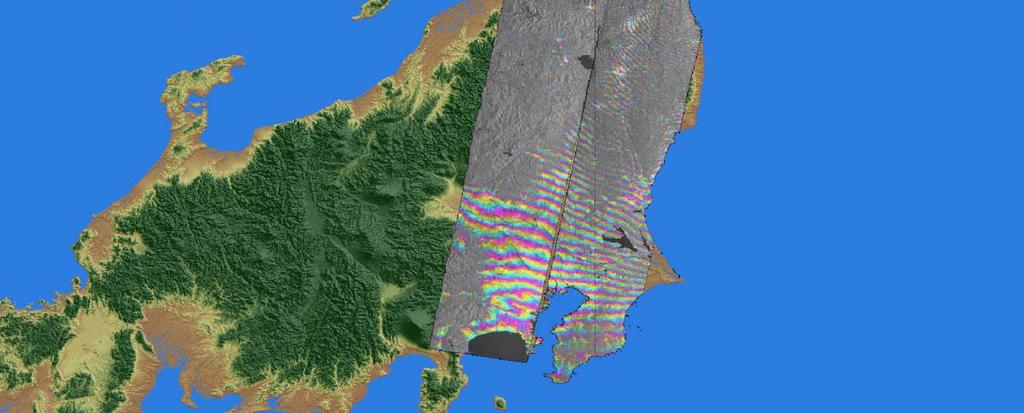
9 Surface movements mapped using InSAR ENVISAT IS6 Three interferometric strips are composed of 13 (track 347, descending orbit), 8 (track 074) and 6 (track 189). The resulting interferogram covers most of Honshu island, the whole epicentral region and a large coastal area. The strips have been unwrapped to measure the Line Of Sight surface movement (right). The maximum displacement reaches about 2.5 m relative to a reference point located nearby the southern boundary.


10 Surface movements mapped using InSAR
 from JPL (Jet Propulsion Laboratory, USA), with data from ascending tracks 401 (time")
11 ALOS-PALSAR data processing was carried out using ROI_PAC (Repeat Orbit Interferometry PACkage) from JPL (Jet Propulsion Laboratory, USA), with data from ascending tracks 401 (time span 28/10/ /3/2011) and 402 (time span 29/9/2010-1/4/2011).
12 ESA made available also data from the ERS2 satellite, previously moved on a new three days revisiting time orbit, providing precise orbit files based on Laser Range data with only two days delay. The optimal ERS2 orbital control allowed getting very short baseline values as well. All data were along ascending track. The choice of the ERS2 processed interferograms, has been done based also on the occurrence of some strong aftershocks (April 7 th, M7.4 and May 5 th, M6.3) after the mainshock of March 11 st.


13


14


15
 obtained")
16 Seismic source modelling GPS and InSAR results have been combined in order to estimate the 3D displacements. We integrated the GPS displacement vectors provided by Piatanesi et al., obtained by comparing the position estimates averaged 15 minutes before and after the main shock, and the ENVISAT InSAR displacement map relevant to the Track 347 (descending orbit) obtained considering the passes of 19/2/2011 and 21/3/2011.
 in order to estimate the gradient displacements tensor.")
17 Seismic source modelling We applied the SISTEM approach (Guglielmino et al., 2011) in order to estimate the gradient displacements tensor. SISTEM takes into account both the in situ geodetic measurements and the DInSAR LOS displacement maps.

18 Seismic source modelling (preliminary results) Forward modeling with a spherical layered self-gravitating coseismic model Rheological layering is obtained by means of a PREM discretization Source geometry is fixed, seismic moment release is obtained with a linear damped least-squares inversion Source parameters: M 0 = Mw = 9.35 The largest misfit is obtained on the vertical component (see next slide)

19 Residuals (observed modeled)
20 Conclusions - The Tohoku-oki Supersite earthquake has been studied using an unprecedented number of EO data, mainly from SAR sensors - The surface displacement field covered most of Honshu island with a maximum LOS deformation up to 2.5 m - The integration of GPS and InSAR has allowed to measure the East, North, Up displacement components - The seismic source modelling revealed that most of the misfit is over the Up component. The slip distribution reveals a maximum along the north sector of the subduction zone - Further studies are addressed to integrate other data sources (tsunami waveforms)

21
22 Thank you!
GEO-VIII November Geohazard Supersites and Natural Laboratories Progress Report. Document 9
 GEO-VIII 16-17 November 2011 Geohazard Supersites and Natural Laboratories Progress Report Document 9 This document is submitted to GEO-VIII for information. Geohazard Supersites and Natural Laboratories
Haiti Earthquake (12-Jan-2010) co-seismic motion using ALOS PALSAR
 co-seismic motion using ALOS PALSAR") Haiti Earthquake (12-Jan-2010) co-seismic motion using ALOS PALSAR Urs Wegmüller, Charles Werner, Maurizio Santoro Gamma Remote Sensing, CH-3073 Gümligen, Switzerland SAR data: JAXA, METI; PALSAR AO Project
Haiti Earthquake (12-Jan-2010) co-seismic motion using ALOS PALSAR Urs Wegmüller, Charles Werner, Maurizio Santoro Gamma Remote Sensing, CH-3073 Gümligen, Switzerland SAR data: JAXA, METI; PALSAR AO Project
Sendai Earthquake NE Japan March 11, Some explanatory slides Bob Stern, Dave Scholl, others updated March
 Sendai Earthquake NE Japan March 11, 2011 Some explanatory slides Bob Stern, Dave Scholl, others updated March 14 2011 Earth has 11 large plates and many more smaller ones. Plates are 100-200 km thick
to: Interseismic strain accumulation and the earthquake potential on the southern San
 Supplementary material to: Interseismic strain accumulation and the earthquake potential on the southern San Andreas fault system by Yuri Fialko Methods The San Bernardino-Coachella Valley segment of the
Magnitude 7.1 NEAR THE EAST COAST OF HONSHU, JAPAN
 Japan was rattled by a strong aftershock and tsunami warning Thursday night nearly a month after a devastating earthquake and tsunami flattened the northeastern coast. This earthquake can be considered
Seismic Activity and Crustal Deformation after the 2011 Off the Pacific Coast of Tohoku Earthquake
 J-RAPID Symposium March 6-7, 2013 Seismic Activity and Crustal Deformation after the 2011 Off the Pacific Coast of Tohoku Earthquake Y. Honkura Tokyo Institute of Technology Japan Science and Technology
Ground surface deformation of L Aquila. earthquake revealed by InSAR time series
 Ground surface deformation of L Aquila earthquake revealed by InSAR time series Reporter: Xiangang Meng Institution: First Crust Monitoring and Application Center, CEA Address: 7 Naihuo Road, Hedong District
Geohazard Supersites and Natural Laboratories
 Geohazard Supersites and Natural Laboratories FRINGE 2011, Frascati, Italy, September 19, 2011 Wolfgang Lengert, ESA Falk Amelung, University of Miami, GEO task lead Craig Dobson, NASA, CEOS task lead
INGV. Giuseppe Pezzo. Istituto Nazionale di Geofisica e Vulcanologia, CNT, Roma. Sessione 1.1: Terremoti e le loro faglie
 Giuseppe Pezzo Istituto Nazionale di Geofisica e Vulcanologia, CNT, Roma giuseppe.pezzo@ingv.it The study of surface deformation is one of the most important topics to improve the knowledge of the deep
Case study of Japan: Reference Frames in Practice
 Case study of Japan: Reference Frames in Practice Basara Miyahara and Koji Matsuo Sponsors: 1 Outline Introduction - Geodetic reference frame of Japan - GEONET : continuous GNSS observation system Geometric
Geohazard Supersites and Natural Laboratories
 Geohazard Supersites and Natural Laboratories FRINGE 2011, Frascati, Italy, September 19, 2011 Wolfgang Lengert, ESA Falk Amelung, University of Miami, GEO task lead Craig Dobson, NASA, CEOS task lead
Source identification for situational awareness of the August 24 th 2016 Central Italy event
 Source identification for situational awareness of the August 24 th 2016 Central Italy event CHRISTIAN BIGNAMI*, CRISTIANO TOLOMEI, GIUSEPPE PEZZO, FRANCESCO GUGLIELMINO, SIMONE ATZORI, ELISA TRASATTI,
22 Bulletin of the Geospatial Information Authority of Japan, Vol.59 December, 2011 Fig. 1 Crustal deformation (horizontal) associated with the 2011 o
 associated with the 2011 o") The Crustal Deformation and Fault Model of the 2011 off the Pacific Coast of Tohoku Earthquake 21 The Crustal Deformation and Fault Model of the 2011 off the Pacific Coast of Tohoku Earthquake Tetsuro
The Crustal Deformation and Fault Model of the 2011 off the Pacific Coast of Tohoku Earthquake 21 The Crustal Deformation and Fault Model of the 2011 off the Pacific Coast of Tohoku Earthquake Tetsuro
Case Study of Japan: Crustal deformation monitoring with GNSS and InSAR
 Technical Seminar Reference Frame in Practice, Case Study of Japan: Crustal deformation monitoring with GNSS and InSAR Basara Miyahara miyahara-b96ip@milt.go.jp Geospatial Information Authority of Japan
INVESTIGATION OF EARTHQUAKE-CYCLE DEFORMATION IN TIBET FROM ALOS PALSAR DATA PI 168 Roland Bürgmann 1, Mong-Han Huang 1, Isabelle Ryder 2, and Eric Fi
 INVESTIGATION OF EARTHQUAKE-CYCLE DEFORMATION IN TIBET FROM ALOS PALSAR DATA PI 168 Roland Bürgmann 1, Mong-Han Huang 1, Isabelle Ryder 2, and Eric Fielding 3 1 Berkeley Seismological Laboratory, University
Geodesy (InSAR, GPS, Gravity) and Big Earthquakes
 and Big Earthquakes") Geodesy (InSAR, GPS, Gravity) and Big Earthquakes Mathew Pritchard Teh-Ru A. Song Yuri Fialko Luis Rivera Mark Simons UJNR Earthquake Research Panel, Morioka, Japan - Nov 6, 2002 Goals Accurate and high
Geodesy (InSAR, GPS, Gravity) and Big Earthquakes Mathew Pritchard Teh-Ru A. Song Yuri Fialko Luis Rivera Mark Simons UJNR Earthquake Research Panel, Morioka, Japan - Nov 6, 2002 Goals Accurate and high
The Tohoku Earthquake 2011 Case.
 Wide Area Deformation map generation with TerraSAR-X Data. The Tohoku Earthquake 2011 Case. N. Yague-Martinez (1), C. Minet (2), M. Eineder (2), B. Schättler (2) (1) Starlab, Spain (2) Remote Sensing Technology
Crustal deformation by the Southeast-off Kii Peninsula Earthquake
 Crustal deformation by the Southeast-off Kii Peninsula Earthquake 51 Crustal deformation by the Southeast-off Kii Peninsula Earthquake Tetsuro IMAKIIRE, Shinzaburo OZAWA, Hiroshi YARAI, Takuya NISHIMURA
Centroid moment-tensor analysis of the 2011 Tohoku earthquake. and its larger foreshocks and aftershocks
 Earth Planets Space, 99, 1 8, 2011 Centroid moment-tensor analysis of the 2011 Tohoku earthquake and its larger foreshocks and aftershocks Meredith Nettles, Göran Ekström, and Howard C. Koss Lamont-Doherty
DETECTION OF CRUSTAL MOVEMENTS IN THE 2011 TOHOKU, JAPAN EARTHQUAKE USING HIGH-RESOLUTION SAR DATA
 Paper No. M-5 DETECTION OF CRUSTAL MOVEMENTS IN THE 2011 TOHOKU, JAPAN EARTHQUAKE USING HIGH-RESOLUTION SAR DATA Fumio Yamazaki 1 and Wen Liu 2 SUMMARY Significant crustal movements were caused by the
Monitoring long-term ground movements and Deep Seated Gravitational
 Monitoring long-term ground movements and Deep Seated Gravitational Slope Deformations by InSAR time series: cases studies in Italy Salvatore Stramondo (1), M. Saroli (1, 2), M. Moro (1, 2), S. Atzori
Title. Author(s)Heki, Kosuke. CitationScience, 332(6036): Issue Date Doc URL. Type. File Information. A Tale of Two Earthquakes
Heki, Kosuke. CitationScience, 332(6036): Issue Date Doc URL. Type. File Information. A Tale of Two Earthquakes") Title A Tale of Two Earthquakes Author(s)Heki, Kosuke CitationScience, 332(6036): 1390-1391 Issue Date 2011-06-17 Doc URL http://hdl.handle.net/2115/48524 Type article (author version) File Information
Title A Tale of Two Earthquakes Author(s)Heki, Kosuke CitationScience, 332(6036): 1390-1391 Issue Date 2011-06-17 Doc URL http://hdl.handle.net/2115/48524 Type article (author version) File Information
Q1-Q CEOS Seismic Pilot report. CEOS Thematic Pilots
 CEOS Thematic Pilots Q1-Q2 2016 CEOS Seismic Pilot report Seismic Pilot/ Objective A, B and C March 2016- PI or PoC: Philippe Bally August 2016 (ESA) and Stefano Salvi (INGV). Collaborating organisations:
The April 6 th 2009, L Aquila (Italy) earthquake: DInSAR analysis and seismic source model inversion
 earthquake: DInSAR analysis and seismic source model inversion") ESA ESRIN 30th November - 4th December 2009 Frascati, Italy The April 6 th 2009, L Aquila (Italy) earthquake: DInSAR analysis and seismic source model inversion Simone Atzori, Christian Bignami, Marco
ESA ESRIN 30th November - 4th December 2009 Frascati, Italy The April 6 th 2009, L Aquila (Italy) earthquake: DInSAR analysis and seismic source model inversion Simone Atzori, Christian Bignami, Marco
6.0 TDMT, M W. IREA-CNR, Napoli, Italy 2. DISPUTER, Università G. D Annunzio, Chieti, Italy 3. Dipartimento della Protezione Civile, Roma, Italy
 An intriguing perspective on the source geometry and slip distribution of the 2016 Amatrice Mw 6.2 earthquake (central Italy) from geological and satellite data P. Tizzani 1, M. Bonano 1, P. Boncio 2,
DETECTION OF CRUSTAL DEFORMATION OF THE NORTHERN PAKISTAN EARTHQUAKE BY SATELLITE DATA. Submitted by Japan **
 UNITED NATIONS E/CONF.97/5/CRP. 5 ECONOMIC AND SOCIAL COUNCIL Seventeenth United Nations Regional Cartographic Conference for Asia and the Pacific Bangkok, 18-22 September 2006 Item 6 (b) of the provisional
DETECTION OF CRUSTAL MOVEMENTS FOR THE 2011 TOHOKU, JAPAN EARTHQUAKE FROM MULTI-TEMPORAL HIGH- RESOLUTION SAR INTENSITY IMAGES
 Meccanica dei Materiali e delle Strutture Vol. 3 (2012), no.2, pp. 25-32 ISSN: 2035-679X Dipartimento di Ingegneria Civile, Ambientale, Aerospaziale, Dei Materiali DICAM DETECTION OF CRUSTAL MOVEMENTS
Centroid-moment-tensor analysis of the 2011 off the Pacific coast of Tohoku Earthquake and its larger foreshocks and aftershocks
 LETTER Earth Planets Space, 63, 519 523, 2011 Centroid-moment-tensor analysis of the 2011 off the Pacific coast of Tohoku Earthquake and its larger foreshocks and aftershocks Meredith Nettles, Göran Ekström,
Seismic Activity near the Sunda and Andaman Trenches in the Sumatra Subduction Zone
 IJMS 2017 vol. 4 (2): 49-54 International Journal of Multidisciplinary Studies (IJMS) Volume 4, Issue 2, 2017 DOI: http://doi.org/10.4038/ijms.v4i2.22 Seismic Activity near the Sunda and Andaman Trenches
Gravitational deformation after the April 6, 2009 L Aquila Earthquake detected by Cosmo-SkyMed
 Gravitational deformation after the April 6, 2009 L Aquila Earthquake detected by Cosmo-SkyMed Christian Bignami 1 ; Matteo Albano 1 ; Salvatore Barba 1 ; Mario Costantini 2 ; Fabio Malvarosa 2 ; Marco
3D temporal evolution of displacements recorded on Mt. Etna from the 2007 to 2010 through the SISTEM method
 3D temporal evolution of displacements recorded on Mt. Etna from the 2007 to 2010 through the SISTEM method Bonforte A., Guglielmino F.,, Puglisi G. INGV Istituto Nazionale di Gofisica e vulcanologia Osservatorio
Tsunami and earthquake in Chile Part 2
 EUROPEAN COMMISSION DIRECTORATE GENERAL JRC JOINT RESEARCH CENTRE Institute for the Protection and Security of the Citizen Global Security and Crisis Management Unit CriTech Sunday, 28 February 2010 Executive
Two Contrasting InSAR Studies of Recent Earthquakes in Tibet
 Two Contrasting InSAR Studies of Recent Earthquakes in Tibet Barry Parsons Department of Earth Sciences University of Oxford John Elliott, Wanpeng Feng,, James Jackson, Zhenhong Li, Xinjian Shan, Alastair
Case Study 1: 2014 Chiang Rai Sequence
 Case Study 1: 2014 Chiang Rai Sequence Overview Mw 6.1 earthquake on 5 May 2014 at 11:08:43 UTC Largest recorded earthquake in Thailand Fault Orientation How does the orientation of the fault affect the
Magnitude 7.9 SE of KODIAK, ALASKA
 A magnitude 7.9 earthquake occurred at 12:31 am local time 181 miles southeast of Kodiak at a depth of 25 km (15.5 miles). There are no immediate reports of damage or fatalities. Light shaking from this
Scaling relations of seismic moment, rupture area, average slip, and asperity size for M~9 subduction-zone earthquakes
 GEOPHYSICAL RESEARCH LETTERS, VOL. 4, 7 74, doi:1.12/grl.976, 213 Scaling relations of seismic moment, rupture area, average slip, and asperity size for M~9 subduction-zone earthquakes Satoko Murotani,
RELOCATION OF THE MACHAZE AND LACERDA EARTHQUAKES IN MOZAMBIQUE AND THE RUPTURE PROCESS OF THE 2006 Mw7.0 MACHAZE EARTHQUAKE
 RELOCATION OF THE MACHAZE AND LACERDA EARTHQUAKES IN MOZAMBIQUE AND THE RUPTURE PROCESS OF THE 2006 Mw7.0 MACHAZE EARTHQUAKE Paulino C. FEITIO* Supervisors: Nobuo HURUKAWA** MEE07165 Toshiaki YOKOI** ABSTRACT
Was the February 2008 Bukavu seismic sequence associated with magma intrusion?
 Was the February 2008 Bukavu seismic sequence associated with magma intrusion? N. d Oreye, C. Lucas National Museum of Natural History, Luxembourg nicolas.doreye@ecgs.lu P. Gonzalez, J. Fernández Univ.
Basics of the modelling of the ground deformations produced by an earthquake. EO Summer School 2014 Frascati August 13 Pierre Briole
 Basics of the modelling of the ground deformations produced by an earthquake EO Summer School 2014 Frascati August 13 Pierre Briole Content Earthquakes and faults Examples of SAR interferograms of earthquakes
Coulomb stress change for the normal-fault aftershocks triggered near the Japan Trench by the 2011 M w 9.0 Tohoku-Oki earthquake
 Earth Planets Space, 64, 1239 1243, 2012 Coulomb stress change for the normal-fault aftershocks triggered near the Japan Trench by the 2011 M w 9.0 Tohoku-Oki earthquake Tamao Sato 1, Shinya Hiratsuka
The Rotational and Gravitational Signature of Recent Great Earthquakes
 The Rotational and Gravitational Signature of Recent Great Earthquakes Richard S. Gross Jet Propulsion Laboratory California Institute of Technology Pasadena, CA 91109 8099, USA 7th IVS General Meeting
THE 2011 TOHOKU EARTHQUAKE IN JAPAN. VSU Lyuben Karavelov, Sofia, Bulgaria. Key words: Tohoku earthquake, strong ground motion, damage
 THE 2011 TOHOKU EARTHQUAKE IN JAPAN Radan Ivanov 1 VSU Lyuben Karavelov, Sofia, Bulgaria Abstract: This earthquake which occurred on March 11, 2011, had a magnitude of 9.0, which places it as the fourth
ABSTRACT. Key words: InSAR; GPS; northern Chile; subduction zone.
 ASPERITIES, BARRIERS AND TRANSITION ZONE IN THE NORTH CHILE SEISMIC GAP: STATE OF THE ART AFTER THE 007 MW 7.7 TOCOPILLA EARTHQUAKE INFERRED BY GPS AND INSAR DATA Marta Bejar Pizarro, Daniel Carrizo, Anne
Seismogeodesy for rapid earthquake and tsunami characterization
 Seismogeodesy for rapid earthquake and tsunami characterization Yehuda Bock Scripps Orbit and Permanent Array Center Scripps Institution of Oceanography READI & NOAA-NASA Tsunami Early Warning Projects
MECHANISM OF THE 2011 TOHOKU-OKI EARTHQUAKE: INSIGHT FROM SEISMIC TOMOGRAPHY
 Proceedings of the International Symposium on Engineering Lessons Learned from the 2011 Great East Japan Earthquake, March 1-4, 2012, Tokyo, Japan MECHANISM OF THE 2011 TOHOKU-OKI EARTHQUAKE: INSIGHT FROM
Coseismic slip model
 Figure 3 - Preliminary highly smoothed model of coseismic slip for the 11 March UCL Institute for Risk & Disaster Reduction Magnitude 9.0 (JMA scale) earthquake Occurred at 02:46:23 pm local time near
ALOS PI Symposium 2009, 9-13 Nov 2009 Hawaii MOTION MONITORING FOR ETNA USING ALOS PALSAR TIME SERIES
 ALOS PI Symposium 2009, 9-13 Nov 2009 Hawaii ALOS Data Nodes: ALOS RA-094 and RA-175 (JAXA) MOTION MONITORING FOR ETNA USING ALOS PALSAR TIME SERIES Urs Wegmüller, Charles Werner and Maurizio Santoro Gamma
The 2011 Tohoku Earthquake and Tsunami Sequence. Mitchell May, EPSC 330
 The 2011 Tohoku Earthquake and Tsunami Sequence Mitchell May, 260556044 EPSC 330 The 2011 earthquake sequence east of Tohoku is classified as a megathrust earthquake off the east coast of Japan. The earthquake
Tsunami waves swept away houses and cars in northern Japan and pushed ships aground.
 Japan was struck by a magnitude 8.9 earthquake off its northeastern coast Friday. This is one of the largest earthquakes that Japan has ever experienced. In downtown Tokyo, large buildings shook violently
The Earthquake of Padang, Sumatra of 30 September 2009 scientific information and update
 The Earthquake of Padang, Sumatra of 30 September 2009 scientific information and update 01-October-2009 Christophe Vigny Directeur de recherches at CNRS Laboratoire de Géologie Geoscience Dept. Of ENS,
Lessons from the 2004 Sumatra earthquake and the Asian tsunami
 Lessons from the 2004 Sumatra earthquake and the Asian tsunami Kenji Satake National Institute of Advanced Industrial Science and Technology Outline 1. The largest earthquake in the last 40 years 2. Tsunami
Magnitude 7.1 PERU. There are early reports of homes and roads collapsed leaving one dead and several dozen injured.
 A magnitude 7.1 earthquake has occurred offshore Peru. The earthquake struck just after 4 a.m. local time and was centered near the coast of Peru, 40 km (25 miles) south-southwest of Acari, Peru at a depth
Journal of Geophysical Research - Solid Earth
 Journal of Geophysical Research - Solid Earth Supporting Information for Transpressional Rupture Cascade of the 2016 M w 7.8 Kaikoura Earthquake, New Zealand Wenbin Xu 1*, Guangcai Feng 2*, Lingsen Meng
14 S. 11/12/96 Mw S. 6/23/01 Mw S 20 S 22 S. Peru. 7/30/95 Mw S. Chile. Argentina. 26 S 10 cm 76 W 74 W 72 W 70 W 68 W
 175 Chapter 5 Comparision of co-seismic and post-seismic slip from the November 12, 1996, M w 7.7 and the June 23, 2001, M w 8.4 southern Peru subduction zone earthquakes 176 Abstract We use InSAR and
Fault model of the 2007 Noto Hanto earthquake estimated from PALSAR radar interferometry and GPS data
 LETTER Earth Planets Space, 60, 99 104, 2008 Fault model of the 2007 Noto Hanto earthquake estimated from PALSAR radar interferometry and GPS data Yo Fukushima 1, Taku Ozawa 2, and Manabu Hashimoto 1 1
Tsunami waveform analyses of the 2006 underthrust and 2007 outer-rise Kurile earthquakes
 Author(s) 2008. This work is licensed under a Creative Commons License. Advances in Geosciences Tsunami waveform analyses of the 2006 underthrust and 2007 outer-rise Kurile earthquakes Y. Tanioka 1, Y.
27th Seismic Research Review: Ground-Based Nuclear Explosion Monitoring Technologies
 GROUND TRUTH OF AFRICAN AND EASTERN MEDITERRANEAN SHALLOW SEISMICITY USING SAR INTERFEROMETRY AND GIBBS SAMPLING INVERSION Benjamin A. Brooks 1, Francisco Gomez 2, Eric A. Sandvol 2, and Neil Frazer 1
Ground deformation in Thessaly, Central Greece, between 1992 and 2000 by means of ERS multi-temporal InSAR
 INGV Ground deformation in Thessaly, Central Greece, between 1992 and 2000 by means of ERS multi-temporal InSAR S. Atzori (1), C. Tolomei (1), S. Salvi (1), A. Ganas (2), S. Stramondo (1) and L. Colini
The Geohazard Supersites and Natural Laboratories (GSNL).
.") The Geohazard Supersites and Natural Laboratories (GSNL). Falk Amelung, University of Miami Mike Poland, Hawaii Volcano Observatory Scott Baker, U of Miami, Unavco Outline: Overview over GSNL (Phase 2)
The Geohazard Supersites and Natural Laboratories (GSNL). Falk Amelung, University of Miami Mike Poland, Hawaii Volcano Observatory Scott Baker, U of Miami, Unavco Outline: Overview over GSNL (Phase 2)
How GNSS CORS in Japan works for geodetic control and disaster mitigations
 ICG Working Group D Reference Frames, Timing and Applications How GNSS CORS in Japan works for geodetic control and disaster mitigations ICG11, Nov. 7-11, 2016, Sochi, Russia Hiromichi TSUJI Geodetic Observation
Chapter 2. Earthquake and Damage
 EDM Report on the Chi-Chi, Taiwan Earthquake of September 21, 1999 2.1 Earthquake Fault 2.1.1 Tectonic Background The island of Taiwan is located in the complex junction where the Eurasian and Philippine
Characteristics of seismic activity before Chile M W 8.8 earthquake in 2010
 Earthq Sci (2010)23: 333 341 333 Doi: 10.1007/s11589-010-0730-x Characteristics of seismic activity before Chile M W 8.8 earthquake in 2010 Yan Xue 1,2, Jie Liu 2 and Gang Li 2 1 Institute of Geophysics,
NUMERICAL SIMULATIONS FOR TSUNAMI FORECASTING AT PADANG CITY USING OFFSHORE TSUNAMI SENSORS
 NUMERICAL SIMULATIONS FOR TSUNAMI FORECASTING AT PADANG CITY USING OFFSHORE TSUNAMI SENSORS Setyoajie Prayoedhie Supervisor: Yushiro FUJII MEE10518 Bunichiro SHIBAZAKI ABSTRACT We conducted numerical simulations
Coseismic slip distribution of the 1946 Nankai earthquake and aseismic slips caused by the earthquake
 Earth Planets Space, 53, 235 241, 2001 Coseismic slip distribution of the 1946 Nankai earthquake and aseismic slips caused by the earthquake Yuichiro Tanioka 1 and Kenji Satake 2 1 Meteorological Research
SUPPLEMENTARY INFORMATION
 SUPPLEMENTARY INFORMATION DOI: 1.138/NGEO177 The Long Precursory Phase of Most Large Interplate Earthquakes Supplementary Information Supplementary Methods 1. Data and Classification We select the earthquakes
In order to obtain a long term monitoring result for the Kilauea Volcano, ALOS PALSAR images taken on Track 287, Frame 38, ascending orbit with 21.5 d
 ALOS PALSAR OBSERVATION OF KILAUEA VOLCANO ACTIVITIES FROM 2006 TO 2009 Zhe Hu, Linlin Ge, Xiaojing Li, Kui Zhang, Alex Hay-Man NG and Chris Rizos Cooperative Research Centre for Spatial Information &
DLR s TerraSAR-X contributes to international fleet of radar satellites to map the Arctic and Antarctica
 DLR s TerraSAR-X contributes to international fleet of radar satellites to map the Arctic and Antarctica The polar regions play an important role in the Earth system. The snow and ice covered ocean and
Lab 9: Satellite Geodesy (35 points)
") Lab 9: Satellite Geodesy (35 points) Here you will work with GPS Time Series data to explore plate motion and deformation in California. This lab modifies an exercise found here: http://www.unavco.org:8080/cws/pbonucleus/draftresources/sanandreas/
Lab 9: Satellite Geodesy (35 points) Here you will work with GPS Time Series data to explore plate motion and deformation in California. This lab modifies an exercise found here: http://www.unavco.org:8080/cws/pbonucleus/draftresources/sanandreas/
Title. Author(s)Fujii, Yoshiaki; Kodama, Jun-ichi; Fukuda, Daisuke. CitationProceedings ISRM Congress 2015, 2015: 513. Issue Date
Fujii, Yoshiaki; Kodama, Jun-ichi; Fukuda, Daisuke. CitationProceedings ISRM Congress 2015, 2015: 513. Issue Date") Title Giant Earthquakes are Occurring at Lunar Phases Spec Author(s)Fujii, Yoshiaki; Kodama, Jun-ichi; Fukuda, Daisuke CitationProceedings ISRM Congress 2015, 2015: 513 Issue Date 2015-05- Doc URL http://hdl.handle.net/2115/5113
Title Giant Earthquakes are Occurring at Lunar Phases Spec Author(s)Fujii, Yoshiaki; Kodama, Jun-ichi; Fukuda, Daisuke CitationProceedings ISRM Congress 2015, 2015: 513 Issue Date 2015-05- Doc URL http://hdl.handle.net/2115/5113
GEO-HAZARDS STUDIES BY PALSAR INTERFEROMETRY PI No: 390 Xiaoli Ding 1, Lei Zhang 1, Guangcai Feng 1, Mi Jiang 1, and Jun Hu 2, 1 The Hong Kong Polytec
 GEO-HAZARDS SUDIES BY PALSAR INERFEROMERY PI No: 390 Xiaoli Ding 1, Lei Zhang 1, Guangcai Feng 1, Mi Jiang 1, and Jun Hu 2, 1 he Hong Kong Polytechnic University, Hung Hom, KLN, Hong Kong 2 Central South
Case Study 2: 2014 Iquique Sequence
 Case Study 2: 2014 Iquique Sequence Overview Mw 8.2 earthquake on 1 April 2014 at 11:08:43 UTC Pictures of damage Seismicity maps Foreshock seismicity -> Main shock -> Aftershock 1 April 2014 11:08:43
4600 Rickenbacker Cswy, Miami 33149, FL. U.S.A., (2)
") POSTSEISMIC DEFORMATION FOLLOWING THE 2010 HAITI EARTHQUAKE: TIME-DEPENDENT SURFACE SUBSIDENCE INDUCED BY GROUNDWATER FLOW IN RESPONSE TO A SUDDEN UPLIFT Shimon Wdowinski (1), Sang-Hoon Hong (1)(2) (1)
POSTSEISMIC DEFORMATION FOLLOWING THE 2010 HAITI EARTHQUAKE: TIME-DEPENDENT SURFACE SUBSIDENCE INDUCED BY GROUNDWATER FLOW IN RESPONSE TO A SUDDEN UPLIFT Shimon Wdowinski (1), Sang-Hoon Hong (1)(2) (1)
Available online at ScienceDirect. Procedia Technology 16 (2014 )
") Available online at www.sciencedirect.com ScienceDirect Procedia Technology 16 (2014 ) 876 885 CENTERIS 2014 - Conference on ENTERprise Information Systems / ProjMAN 2014 - International Conference on
Available online at www.sciencedirect.com ScienceDirect Procedia Technology 16 (2014 ) 876 885 CENTERIS 2014 - Conference on ENTERprise Information Systems / ProjMAN 2014 - International Conference on
REPORT ON THE TOHOKU AREA PASIFIC OFFSHORE EARTHQUAKE
 REPORT ON THE TOHOKU AREA PASIFIC OFFSHORE EARTHQUAKE GENERAL PERSPECTIVE The Highest Magnitude Ever Recorded The 2011 off the Pacific Coast of Tohoku Earthquake (hereafter, the 2011 Tohoku- Pacific Earthquake
Line of Sight Displacement from ALOS-2 Interferometry: Mw 7.8 Gorkha Earthquake and Mw 7.3 Aftershock
 Line of Sight Displacement from ALOS-2 Interferometry: Mw 7.8 Gorkha Earthquake and Mw 7.3 Aftershock Eric O. Lindsey 1 Ryo Natsuaki 2 Xiaohua Xu 1 Masanobu Shimada 2 Manabu, Hashimoto 3 Diego Melgar 4
Co-seismic slip from the July 30, 1995, M w 8.1 Antofagasta, Chile, earthquake as constrained by InSAR and GPS observations
 98 Chapter 3 Co-seismic slip from the July 30, 1995, M w 8.1 Antofagasta, Chile, earthquake as constrained by InSAR and GPS observations Published by Blackwell Publishing Ltd. in Geophysical Journal International
Source rupture process of the 2003 Tokachi-oki earthquake determined by joint inversion of teleseismic body wave and strong ground motion data
 LETTER Earth Planets Space, 56, 311 316, 2004 Source rupture process of the 2003 Tokachi-oki earthquake determined by joint inversion of teleseismic body wave and strong ground motion data Yuji Yagi International
APLICATION OF INSAR TO THE STUDY OF GROUND DEFORMATION IN THE MEXICALI VALLEY, B. C., MEXICO.
 APLICATION OF INSAR TO THE STUDY OF GROUND DEFORMATION IN THE MEXICALI VALLEY, B. C., MEXICO. O. Sarychikhina (1), R. Mellors (2), E. Glowacka (1). (1) Centro de Investigacion Cientifica y Educaccion Superior
Complicated repeating earthquakes on the convergent plate boundary: Rupture processes of the 1978 and 2005 Miyagi-ken Oki earthquakes
 Complicated repeating earthquakes on the convergent plate boundary: Rupture processes of the 1978 and 2005 Miyagi-ken Oki earthquakes Changjiang Wu 1 and Kazuki Koketsu Earthquake Research Institute, University
InSAR-derived Crustal Deformation and Reverse Fault Motion of the 2017 Iran-Iraq Earthquake in the Northwestern Part of the Zagros Orogenic Belt
 InSAR-derived Crustal Deformation and Reverse Fault Motion of the 2017 Iran-Iraq Earthquake in the Northwestern Part of the Zagros Orogenic Belt Tomokazu Kobayashi, Yu Morishita, Hiroshi Yarai and Satoshi
Magnitude 8.3 SEA OF OKHOTSK
 A powerful earthquake in Russia's Far East was felt as far away as Moscow, about 7,000 kilometers (4,400 miles) west of the epicenter, but no casualties or damage were reported. The epicenter was in the
Magnitude 7.7 QUEEN CHARLOTTE ISLANDS REGION
 A major 7.7 magnitude earthquake struck at 8:04 PM local time in western British Columbia, Canada. The epicenter is located on Moresby Island, the southern large island in the Queen Charlotte Islands region.
crustal structure experiment beneath Wairarapa - Wellington area: results from SAHKE
 crustal structure experiment beneath Wairarapa - Wellington area: results from SAHKE Tim Stern and SAHKE team* * VUW, GNS, University of Southern California, University of Tokyo(Japan) SAHKE = Seismic
Widespread Ground Motion Distribution Caused by Rupture Directivity during the 2015 Gorkha, Nepal Earthquake
 Widespread Ground Motion Distribution Caused by Rupture Directivity during the 2015 Gorkha, Nepal Earthquake Kazuki Koketsu 1, Hiroe Miyake 2, Srinagesh Davuluri 3 and Soma Nath Sapkota 4 1. Corresponding
Magnitude 7.6 SOUTH OF IQUIQUE, CHILE
 A powerful aftershock struck off northern Chile prompting an evacuation of the coastal area and raising fears of a tsunami. This magnitude 7.6 earthquake is the largest of a series of aftershocks following
Implementation of Multi-Temporal InSAR to monitor pumping induced land subsidence in Pingtung Plain, Taiwan
 Implementation of Multi-Temporal InSAR to monitor pumping induced land subsidence in Pingtung Plain, Taiwan Presenter: Oswald Advisor: Chuen-Fa Ni Date: March 09, 2017 Literature Review Pingtung Plain
NOTES AND CORRESPONDENCE Segmented Faulting Process of Chelungpu Thrust: Implication of SAR Interferograms
 , Vol. 14, No.2, 241-247, June 2003 NOTES AND CORRESPONDENCE Segmented Faulting Process of Chelungpu Thrust: Implication of SAR Interferograms Chien-Chih Chen 1,*, Chung-Pai Chang 2, and Kun-Shan Chen
Magnitude 8.2 NORTHWEST OF IQUIQUE, CHILE
 An 8.2-magnitude earthquake struck off the coast of northern Chile, generating a local tsunami. The USGS reported the earthquake was centered 95 km (59 miles) northwest of Iquique at a depth of 20.1km
27th Seismic Research Review: Ground-Based Nuclear Explosion Monitoring Technologies
 GROUND TRUTH LOCATIONS USING SYNERGY BETWEEN REMOTE SENSING AND SEISMIC METHODS-APPLICATION TO CHINESE AND NORTH AFRICAN EARTHQUAKES C. K. Saikia 1, H. K. Thio 2, D. V. Helmberger 2, G. Ichinose 1, and
Earthquakes and Tsunamis
 Earthquakes and Tsunamis Kenji Satake Earthquake Research Institute University of Tokyo 1 Part I 2011 Tohoku earthquake and tsunami 2 Fukushima Dai ichi NPP accident Earthquake ground motion Reactors automatically
SOURCE INVERSION AND INUNDATION MODELING TECHNOLOGIES FOR TSUNAMI HAZARD ASSESSMENT, CASE STUDY: 2001 PERU TSUNAMI
 Paper No. TS-4-1 SOURCE INVERSION AND INUNDATION MODELING TECHNOLOGIES FOR TSUNAMI HAZARD ASSESSMENT, CASE STUDY: 2001 PERU TSUNAMI Bruno Adriano 1, Shunichi Koshimura 2 and Yushiro Fujii 3 ABSTRACT The
Blank line 10 pt Keywords: Response Characteristics, Skyscraper, Tohoku-Oki earthquake, Natural operiod
 A Study on the Response Characteristics of a High-Rise Building Built on the Reclaimed Land along the Osaka Bay Yuta Akizuki Graduate School of Engineering, Kyoto University, Kyoto, Japan Blank Line 9
Shattering a plate boundary: the 2016 Mw 7.8 Kaikōura earthquake
 Shattering a plate boundary: the 2016 Mw 7.8 Kaikōura earthquake Presenter: Pilar Villamor, On behalf of many, many others... 14 November 2016 Kaikōura Earthquake This talk - Background - During the Kaikōura
LETTER Earth Planets Space, 56, , 2004
 LETTER Earth Planets Space, 56, 353 357, 2004 Deep seismic activities preceding the three large shallow earthquakes off south-east Hokkaido, Japan the 2003 Tokachi-oki earthquake, the 1993 Kushiro-oki
Magnitude 7.0 NEW CALEDONIA
 A magnitude 7.0 earthquake has occurred 82km ENE of Maré Island, the secondlargest of the Loyalty Islands in the archipelago of New Caledonia. The initial report of the magnitude and shallow 10km depth
Geophysical Journal International
 Fast determination of megathrust rupture processes based on teleseismic waveform in a global D velocity structure and tsunami wave estimation with an application to the 0 Tohoku-Oki earthquake Journal:
COMPARISON OF COSEISMIC DISPLACEMENTS OBTAINED FROM STRONG MOTION ACCELEROGRAMS AND GPS DATA IN JAPAN
 COMPARISON OF COSEISMIC DISPLACEMENTS OBTAINED FROM STRONG MOTION ACCELEROGRAMS AND GPS DATA IN JAPAN Fumio YAMAZAKI 1, Luis MOYA 2, Kiminobu ANEKOJI 3 and Wen LIU 4 ABSTRACT Strong motion seismometers
1.3 Short Review: Preliminary results and observations of the December 2004 Great Sumatra Earthquake Kenji Hirata
 1.3 Short Review: Preliminary results and observations of the December 2004 Great Sumatra Earthquake Kenji Hirata We give a brief review about observations and preliminary results regarding the 2004 great
Displacement field and slip distribution of the 2005 Kashmir earthquake from SAR imagery
 Click Here for Full Article GEOPHYSICAL RESEARCH LETTERS, VOL. 33,, doi:10.1029/2006gl027193, 2006 Displacement field and slip distribution of the 2005 Kashmir earthquake from SAR imagery E. Pathier, 1
AVERAGE AND VARIATION OF FOCAL MECHANISM AROUND TOHOKU SUBDUCTION ZONE
 13 th World Conference on Earthquake Engineering Vancouver, B.C., Canada August 1-6, 24 Paper No. 414 AVERAGE AND VARIATION OF FOCAL MECHANISM AROUND TOHOKU SUBDUCTION ZONE Shunroku YAMAMOTO 1 Naohito