Case Study 2: 2014 Iquique Sequence
|
|
|
- Bridget McCoy
- 6 years ago
- Views:
Transcription
1 Case Study 2: 2014 Iquique Sequence

2 Overview Mw 8.2 earthquake on 1 April 2014 at 11:08:43 UTC Pictures of damage Seismicity maps Foreshock seismicity -> Main shock -> Aftershock 1 April :08:43 UTC, Mw 8.2 earthquake

3 Santiago, Chile

4 Iquique, Chile

5 Port of Iquique, Chile
6 16 March
7 16 March 17 March
8 16 March 17 March 22 March
9 16 March 17 March 22 March 23 March
10 16 March 17 March 22 March 23 March Prior to main shock

11 16 March 17 March 22 March 23 March Prior to main shock 1 April

12 16 March 17 March 22 March 23 March Prior to main shock 1 April 10 April
13 Foreshock Displacements Exercise: using the foreshocks Mw 6.0 and larger, predict the evolution of displacements at GPS stations along the Chile coast. Compare the total predicted horizontal displacements from all these foreshocks with the observed GPS displacements immediately prior to the 1 April Mw 8.2 main shock.
14 Foreshock Displacements Search the Global Centroid Moment Tensor catalog for the earthquake parameters you need

15
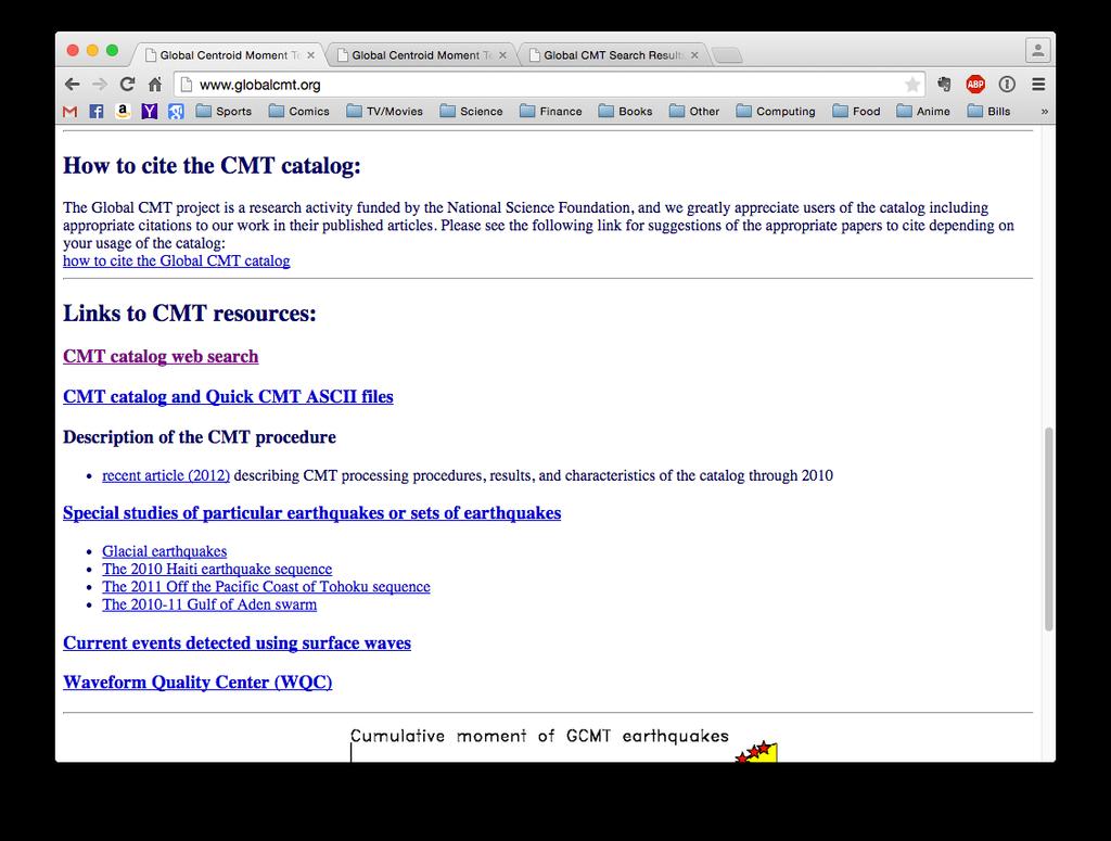
16
17
18 Starting Date: 16 March 2014
19 Number of days from start: 16
20 Magnitude 6.0 and greater

21 Latitude: -21.0º to -19.5º Longitude: -71.5º to -70.0º
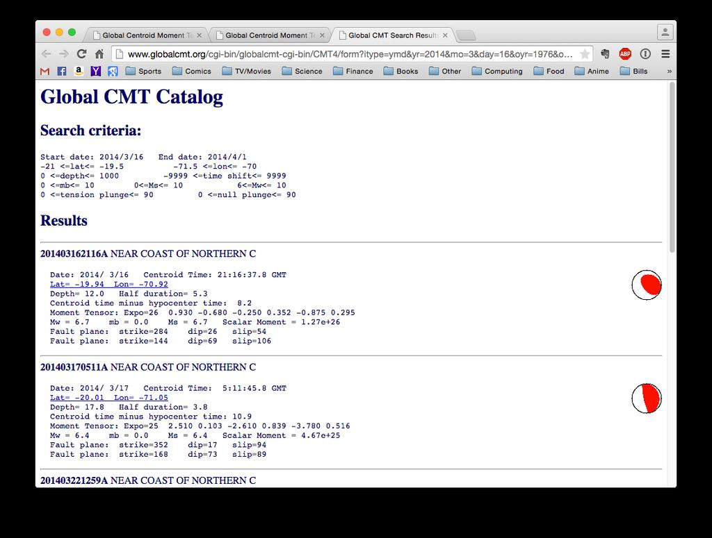
22
23 Foreshock Displacements Reminder from Chiang Rai, Thailand, case study: we usually know the magnitude of the earthquake, and have to estimate the dimensions and slip of the earthquake for use with O92UTIL Typically, both slip and fault area increase systematically with magnitude
24 Foreshock Displacements Wells and Coppersmith (1994)
25 Foreshock Displacements Wells and Coppersmith (1994)
26 Foreshock Displacements O92UTIL implements several empirical relations, allowing the user to put magnitude in the input fault file instead of fault slip and dimensions
27 Foreshock Displacements Input fault file (fault.dat) Lon Lat Dep Strike Dip Rake Mag Same as previous input format
28 Foreshock Displacements Input fault file (fault.dat) Lon Lat Dep Strike Dip Rake Mag
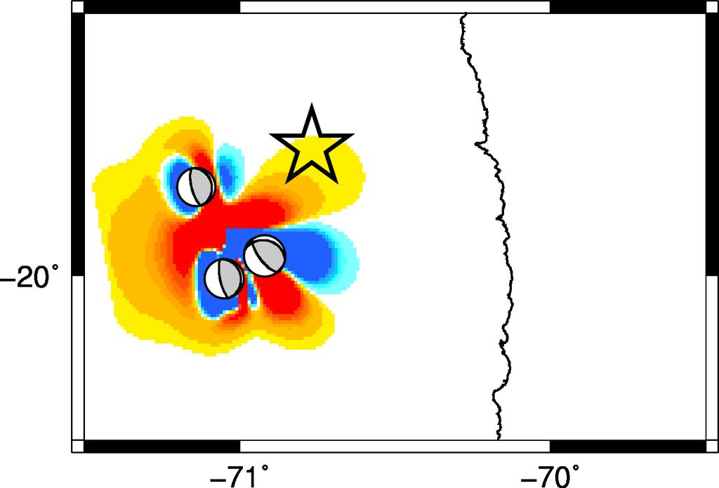
29 Foreshock Displacements o92util -mag fault.dat -sta station.dat... (instead of o92util -flt fault.dat...)
30 Foreshock Displacements GPS stations on west coast of Chile What are the predicted horizontal displacements at these 5 stations?
31 Foreshock Displacements GPS stations on west coast of Chile What are the predicted horizontal displacements at these 5 stations?
32 Foreshock Displacements GPS stations on west coast of Chile What are the predicted horizontal displacements at these 5 stations? Station East (mm) North (mm) AEDA ATJN CRSC IQQE PSGA Observed displacements
 AEDA -4.0 2.9 ATJN -10.0-7.2 CRSC -2.4 2.3 IQQE -7.9 1.1 PSGA -14.")
33 Foreshock Displacements GPS stations on west coast of Chile Station East (mm) North (mm) AEDA ATJN CRSC IQQE PSGA
34 Foreshock Displacements faults.dat:
35 Foreshock Displacements GPSloc.dat: AEDA ATJN CRSC IQQE PSGA
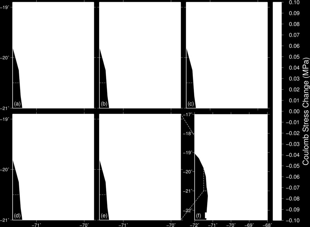
36 Foreshock Triggering Exercise: model the stress change evolution on the subduction zone plate boundary resulting from the largest foreshocks. Were these events triggered? How do these earthquakes change the state of stress at the Mw 8.2 hypocenter?
37 Foreshock Triggering We have earthquake parameters from the previous exercise To resolve stresses, we need the location of the plate boundary at depth and the kinematics (orientation and slip direction) of the plate interface
38 Foreshock Triggering Use GRID to generate the locations for computing CS on the plate boundary Recall: GRID can create a horizontal or a dipping plane; which is more appropriate for a subduction zone plate boundary? What is a good reference point for the grid?
39 Foreshock Triggering One option is to use a plate interface model to determine a reference point on the plane of interest For example, USGS Slab 1.0 earthquake.usgs.gov/data/slab/

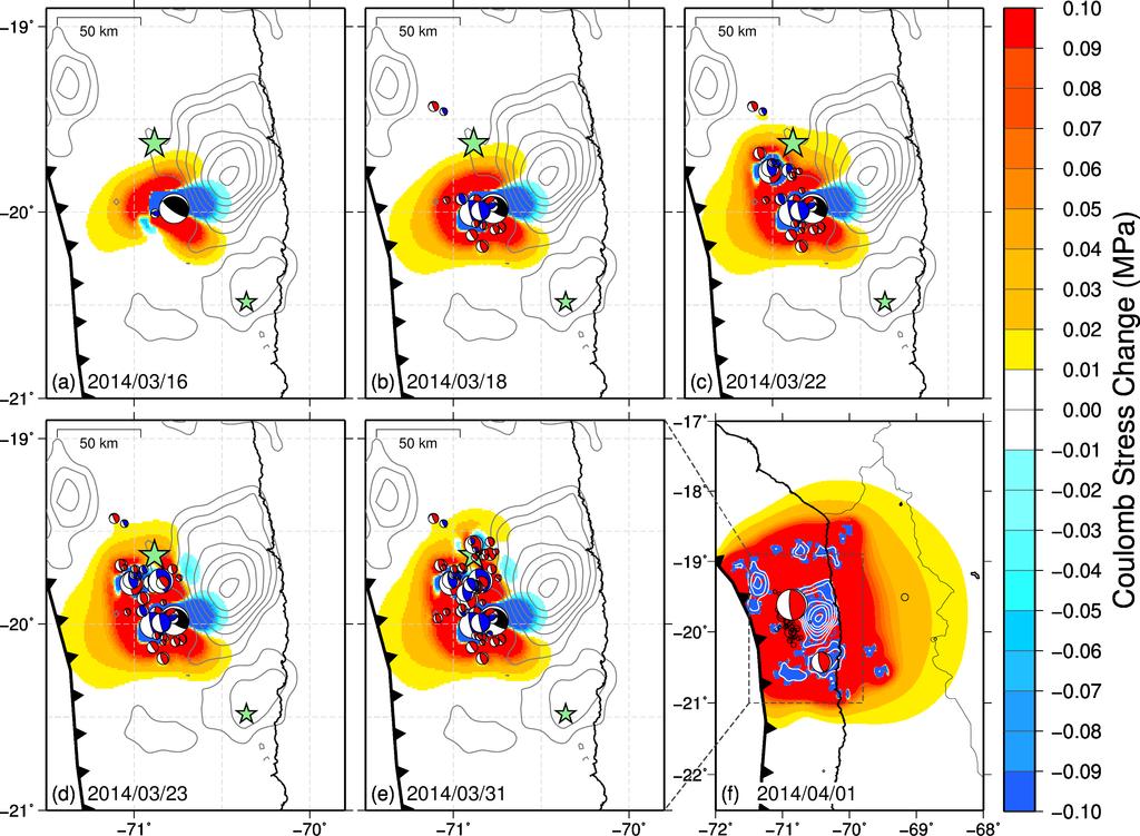
40 Try the interactive map
41 Option below map to search for plate boundary parameters at coordinates of interest.

42 The reference point might be the earthquake hypocenter, centroid, etc.
43 Foreshock Triggering Using the Mw 8.2 centroid as the reference coordinate (-70.5ºE, -19.8ºN), Slab 1.0 gives a depth for the plate boundary at this point of 36 km Also yields strike and dip; are these values consistent with the foreshock kinematics?
44 Foreshock Triggering
45 Foreshock Triggering
46 Foreshock Triggering
47 Foreshock Triggering
48 Main Shock Triggering Exercise: model the stress change on the plate interface resulting from the 1 April main shock. How does this compare to the location of the 3 April Mw 7.7 aftershock? You can find the FFM on the USGS website.

49 Main Shock Triggering
50 Main Shock Triggering o92util -ffm iquique_2014.ffm...

51 Main Shock Triggering Noisy colors! Two reasons: Slip in every subfault Using one plane instead of plate boundary with changing dip
52
53 Main Shock Triggering Exercise: What does the stress change from the 1 April main shock look like in cross-section?

54 Main Shock Triggering
Case Study 1: 2014 Chiang Rai Sequence
 Case Study 1: 2014 Chiang Rai Sequence Overview Mw 6.1 earthquake on 5 May 2014 at 11:08:43 UTC Largest recorded earthquake in Thailand Fault Orientation How does the orientation of the fault affect the
Introduction to Displacement Modeling
 Introduction to Displacement Modeling Introduction Deformation on the Earth surface informs us about processes and material properties below surface Observation tools: GPS (static-dynamic) InSAR (static)
Resolving Stress Components and Earthquake Triggering
 Resolving Stress Components and Earthquake Triggering Earthquake Triggering Do certain events make an earthquake more likely to occur? Earthquakes Slow Slip Wastewater Fluids Dams The focus of this presentation
Tsunami and earthquake in Chile Part 2
 EUROPEAN COMMISSION DIRECTORATE GENERAL JRC JOINT RESEARCH CENTRE Institute for the Protection and Security of the Citizen Global Security and Crisis Management Unit CriTech Sunday, 28 February 2010 Executive
Magnitude 7.1 NEAR THE EAST COAST OF HONSHU, JAPAN
 Japan was rattled by a strong aftershock and tsunami warning Thursday night nearly a month after a devastating earthquake and tsunami flattened the northeastern coast. This earthquake can be considered
Preliminary slip model of M9 Tohoku earthquake from strongmotion stations in Japan - an extreme application of ISOLA code.
 Preliminary slip model of M9 Tohoku earthquake from strongmotion stations in Japan - an extreme application of ISOLA code. J. Zahradnik 1), F. Gallovic 1), E. Sokos 2) G-A. Tselentis 2) 1) Charles University
Once you have opened the website with the link provided choose a force: Earthquakes
 Name: Once you have opened the website with the link provided choose a force: Earthquakes When do earthquakes happen? On the upper left menu, choose number 1. Read What is an Earthquake? Earthquakes happen
Magnitude 8.2 NORTHWEST OF IQUIQUE, CHILE
 An 8.2-magnitude earthquake struck off the coast of northern Chile, generating a local tsunami. The USGS reported the earthquake was centered 95 km (59 miles) northwest of Iquique at a depth of 20.1km
Synthetic Near-Field Rock Motions in the New Madrid Seismic Zone
 Synthetic Near-Field Rock Motions in the New Madrid Seismic Zone Genda Chen*, Ph.D., P.E., and Mostafa El-Engebawy Engebawy,, Ph.D. *Associate Professor of Civil Engineering Department of Civil, Architecture
Crustal deformation by the Southeast-off Kii Peninsula Earthquake
 Crustal deformation by the Southeast-off Kii Peninsula Earthquake 51 Crustal deformation by the Southeast-off Kii Peninsula Earthquake Tetsuro IMAKIIRE, Shinzaburo OZAWA, Hiroshi YARAI, Takuya NISHIMURA
Lab 9: Satellite Geodesy (35 points)
") Lab 9: Satellite Geodesy (35 points) Here you will work with GPS Time Series data to explore plate motion and deformation in California. This lab modifies an exercise found here: http://www.unavco.org:8080/cws/pbonucleus/draftresources/sanandreas/
Lab 9: Satellite Geodesy (35 points) Here you will work with GPS Time Series data to explore plate motion and deformation in California. This lab modifies an exercise found here: http://www.unavco.org:8080/cws/pbonucleus/draftresources/sanandreas/
AVERAGE AND VARIATION OF FOCAL MECHANISM AROUND TOHOKU SUBDUCTION ZONE
 13 th World Conference on Earthquake Engineering Vancouver, B.C., Canada August 1-6, 24 Paper No. 414 AVERAGE AND VARIATION OF FOCAL MECHANISM AROUND TOHOKU SUBDUCTION ZONE Shunroku YAMAMOTO 1 Naohito
Seismic Source Mechanism
 Seismic Source Mechanism Yuji Yagi (University of Tsukuba) Earthquake Earthquake is a term used to describe both failure process along a fault zone, and the resulting ground shaking and radiated seismic
Data Repository of Paper: The role of subducted sediments in plate interface dynamics as constrained by Andean forearc (paleo)topography
topography") Data Repository of Paper: The role of subducted sediments in plate interface dynamics as constrained by Andean forearc (paleo)topography Nicolás J. Cosentino 1*, Felipe Aron 2,3, Jorge G. F. Crempien 2,3,
Data Repository of Paper: The role of subducted sediments in plate interface dynamics as constrained by Andean forearc (paleo)topography Nicolás J. Cosentino 1*, Felipe Aron 2,3, Jorge G. F. Crempien 2,3,
RELOCATION OF THE MACHAZE AND LACERDA EARTHQUAKES IN MOZAMBIQUE AND THE RUPTURE PROCESS OF THE 2006 Mw7.0 MACHAZE EARTHQUAKE
 RELOCATION OF THE MACHAZE AND LACERDA EARTHQUAKES IN MOZAMBIQUE AND THE RUPTURE PROCESS OF THE 2006 Mw7.0 MACHAZE EARTHQUAKE Paulino C. FEITIO* Supervisors: Nobuo HURUKAWA** MEE07165 Toshiaki YOKOI** ABSTRACT
Advantages of Regional and Global Data Exchange. Gavin Hayes U.S. Geological Survey, National Earthquake Information Center
 Advantages of Regional and Global Data Exchange Gavin Hayes U.S. Geological Survey, National Earthquake Information Center USGS NEIC Global Earthquake Response Area of responsibility => Global BUT - domestically,
Tsunami waves swept away houses and cars in northern Japan and pushed ships aground.
 Japan was struck by a magnitude 8.9 earthquake off its northeastern coast Friday. This is one of the largest earthquakes that Japan has ever experienced. In downtown Tokyo, large buildings shook violently
Magnitude 7.6 SOUTH OF IQUIQUE, CHILE
 A powerful aftershock struck off northern Chile prompting an evacuation of the coastal area and raising fears of a tsunami. This magnitude 7.6 earthquake is the largest of a series of aftershocks following
Rupture Characteristics of Major and Great (M w 7.0) Megathrust Earthquakes from : 1. Source Parameter Scaling Relationships
 Megathrust Earthquakes from : 1. Source Parameter Scaling Relationships") Journal of Geophysical Research Solid Earth Supporting Information for Rupture Characteristics of Major and Great (M w 7.0) Megathrust Earthquakes from 1990-2015: 1. Source Parameter Scaling Relationships
Journal of Geophysical Research Solid Earth Supporting Information for Rupture Characteristics of Major and Great (M w 7.0) Megathrust Earthquakes from 1990-2015: 1. Source Parameter Scaling Relationships
Magnitude 7.6 & 7.4 SOLOMON ISLANDS
 A magnitude 7.6 earthquake struck near the Solomon Islands on Sunday morning local time; there were no immediate reports of damage. The earthquake was centered 100 km (60 miles) south of Kira Kira, a town
Centroid moment-tensor analysis of the 2011 Tohoku earthquake. and its larger foreshocks and aftershocks
 Earth Planets Space, 99, 1 8, 2011 Centroid moment-tensor analysis of the 2011 Tohoku earthquake and its larger foreshocks and aftershocks Meredith Nettles, Göran Ekström, and Howard C. Koss Lamont-Doherty
Magnitude 7.0 PERU. This region of the Andes is a sparsely populated area, there were no immediate reports of injuries or damage.
 A magnitude 7.0 earthquake occurred in southeastern Peru on Friday about 27 kilometers northeast of the town of Azángaro, Peru, near the border with Bolivia. The earthquake occurred at a depth of 257.4
SUPPLEMENTARY INFORMATION
 doi:10.1038/nature11492 Figure S1 Short-period Seismic Energy Release Pattern Imaged by F-net. (a) Locations of broadband seismograph stations in Japanese F-net used for the 0.5-2.0 Hz P wave back-projection
OCEAN/ESS 410. Lab 12. Earthquake Focal Mechanisms. You can write your answers to all be (e) on this paper.
 on this paper.") Lab 1. Earthquake Focal Mechanisms You can write your answers to all be (e) on this paper. In this class we are going to use P-wave first motions to obtain a double-couple focal mechanism for a subduction
Lab 1. Earthquake Focal Mechanisms You can write your answers to all be (e) on this paper. In this class we are going to use P-wave first motions to obtain a double-couple focal mechanism for a subduction
Magnitude 7.0 NEW CALEDONIA
 A magnitude 7.0 earthquake has occurred 82km ENE of Maré Island, the secondlargest of the Loyalty Islands in the archipelago of New Caledonia. The initial report of the magnitude and shallow 10km depth
Case Study of Japan: Crustal deformation monitoring with GNSS and InSAR
 Technical Seminar Reference Frame in Practice, Case Study of Japan: Crustal deformation monitoring with GNSS and InSAR Basara Miyahara miyahara-b96ip@milt.go.jp Geospatial Information Authority of Japan
Rapid source characterization of the 2011 M w 9.0 off the Pacific coast of Tohoku Earthquake
 LETTER Earth Planets Space, 63, 529 534, 2011 Rapid source characterization of the 2011 M w 9.0 off the Pacific coast of Tohoku Earthquake Gavin P. Hayes 1,2 1 U.S. Geological Survey, National Earthquake
SUPPLEMENTARY INFORMATION
 SUPPLEMENTARY INFORMATION DOI: 1.138/NGEO177 The Long Precursory Phase of Most Large Interplate Earthquakes Supplementary Information Supplementary Methods 1. Data and Classification We select the earthquakes
The March 11, 2011, Tohoku-oki earthquake (Japan): surface displacement and source modelling
: surface displacement and source modelling") The March 11, 2011, Tohoku-oki earthquake (Japan): surface displacement and source modelling Salvatore Stramondo Bignami C., Borgstrom S., Chini M., Guglielmino F., Melini D., Puglisi G., Siniscalchi V.,
The March 11, 2011, Tohoku-oki earthquake (Japan): surface displacement and source modelling Salvatore Stramondo Bignami C., Borgstrom S., Chini M., Guglielmino F., Melini D., Puglisi G., Siniscalchi V.,
Vertical to Horizontal (V/H) Ratios for Large Megathrust Subduction Zone Earthquakes
 Ratios for Large Megathrust Subduction Zone Earthquakes") Vertical to Horizontal (V/H) Ratios for Large Megathrust Subduction Zone Earthquakes N.J. Gregor Consultant, Oakland, California, USA N.A. Abrahamson University of California, Berkeley, USA K.O. Addo BC
Vertical to Horizontal (V/H) Ratios for Large Megathrust Subduction Zone Earthquakes N.J. Gregor Consultant, Oakland, California, USA N.A. Abrahamson University of California, Berkeley, USA K.O. Addo BC
Simulation of Strong Ground Motions for a Shallow Crustal Earthquake in Japan Based on the Pseudo Point-Source Model
 6 th International Conference on Earthquake Geotechnical Engineering -4 November 25 Christchurch, New Zealand Simulation of Strong Ground Motions for a Shallow Crustal Earthquake in Japan Based on the
TSUNAMI PROPAGATION AND INUNDATION MODELINGS ALONG SOUTH-EAST COAST OF PAPUA NEW GUINEA
 TSUNAMI PROPAGATION AND INUNDATION MODELINGS ALONG SOUTH-EAST COAST OF PAPUA NEW GUINEA Martin WAREK Supervisor: Yushiro FUJII MEE12620 Bunichiro SHIBAZAKI ABSTRACT This study covers tsunami generation,
Centroid-moment-tensor analysis of the 2011 off the Pacific coast of Tohoku Earthquake and its larger foreshocks and aftershocks
 LETTER Earth Planets Space, 63, 519 523, 2011 Centroid-moment-tensor analysis of the 2011 off the Pacific coast of Tohoku Earthquake and its larger foreshocks and aftershocks Meredith Nettles, Göran Ekström,
Magnitude 7.6 & 7.6 PERU
 Two deep 7.6 magnitude earthquakes have shaken a sparsely populated jungle region near the Peru-Brazil border in southeast Peru. There were no immediate reports of injuries or damage. The second M 7.6
Rupture process of the 2010 M w 7.8 Mentawai tsunami earthquake from joint inversion of near-field hr-gps and
 Rupture process of the 2010 M w 7.8 Mentawai tsunami earthquake from joint inversion of near-field hr-gps and teleseismic body wave recordings constrained by tsunami observations Han Yue 1, Thorne Lay
The Mw 6.2 Leonidio, southern Greece earthquake of January 6, 2008: Preliminary identification of the fault plane.
 The Mw 6.2 Leonidio, southern Greece earthquake of January 6, 28: Preliminary identification of the fault plane. J. Zahradnik 1, E. Sokos 2, A.Serpetsidaki 2, and G A.Tselentis 2 1 Charles University in
SOURCE INVERSION AND INUNDATION MODELING TECHNOLOGIES FOR TSUNAMI HAZARD ASSESSMENT, CASE STUDY: 2001 PERU TSUNAMI
 Paper No. TS-4-1 SOURCE INVERSION AND INUNDATION MODELING TECHNOLOGIES FOR TSUNAMI HAZARD ASSESSMENT, CASE STUDY: 2001 PERU TSUNAMI Bruno Adriano 1, Shunichi Koshimura 2 and Yushiro Fujii 3 ABSTRACT The
Tsunami Simulation of 2009 Dusky Sound Earthquake in New Zealand
 Tsunami Simulation of 2009 Dusky Sound Earthquake in New Zealand Polina Berezina 1 Institute of Geology, Taras Shevchenko National University of Kyiv, Kyiv, Ukraine Supervisor: Prof. Kenji Satake Earthquake
Internal Layers of the Earth
 Lecture #4 notes Geology 3950, Spring 2006; CR Stern Seismic waves, earthquake magnitudes and location, and internal earth structure (pages 28-95 in the 4 th edition and 28-32 and 50-106 in the 5 th edition)
Seismogeodesy for rapid earthquake and tsunami characterization
 Seismogeodesy for rapid earthquake and tsunami characterization Yehuda Bock Scripps Orbit and Permanent Array Center Scripps Institution of Oceanography READI & NOAA-NASA Tsunami Early Warning Projects
The IISEE earthquake catalog, Catalog of Damaging Earthquakes in the World, IISEE-NET,, and BRI strong motion observation
 The IISEE earthquake catalog, Catalog of Damaging Earthquakes in the World, IISEE-NET,, and BRI strong motion observation Tatsuhiko Hara International Institute of Seismology and Earthquake Engineering,
Magnitude 7.1 SOUTH SANDWICH ISLANDS
 A magnitude 7.1 earthquake occurred at a depth of 164.7 km (102 miles) in the South Sandwich Islands, an uninhabited British territory off the coast of Argentina in the southern Atlantic Ocean. Antarctica
Tsunami Simulations after the Mw7.5 78km N of Palu, Indonesia September 28, 2018
 Tsunami Simulations after the Mw7.5 78km N of Palu, Indonesia September 28, 2018 Luisa Urra, Erick Mas, Luis Moya, Shunichi Koshimura LABORATORY OF REMOTE SENSING AND GEOINFORMATICS FOR DISASTER MANAGEMENT
NUMERICAL SIMULATIONS FOR TSUNAMI FORECASTING AT PADANG CITY USING OFFSHORE TSUNAMI SENSORS
 NUMERICAL SIMULATIONS FOR TSUNAMI FORECASTING AT PADANG CITY USING OFFSHORE TSUNAMI SENSORS Setyoajie Prayoedhie Supervisor: Yushiro FUJII MEE10518 Bunichiro SHIBAZAKI ABSTRACT We conducted numerical simulations
FULL MOMENT TENSOR ANALYSIS USING FIRST MOTION DATA AT THE GEYSERS GEOTHERMAL FIELD
 PROCEEDINGS, Thirty-Eighth Workshop on Geothermal Reservoir Engineering Stanford University, Stanford, California, February 11-13, 2013 SGP-TR-198 FULL MOMENT TENSOR ANALYSIS USING FIRST MOTION DATA AT
Lesvos June 12, 2017, Mw 6.3 event, a quick study of the source
 Lesvos June 12, 2017, Mw 6.3 event, a quick study of the source E. Sokos 1) and J. Zahradník 2) 1) University of Patras, Greece 2) Charles University, Prague, Czech Republic Report sent to EMSC on 21/06/2017
Triggering of earthquakes during the 2000 Papua New Guinea earthquake sequence
 JOURNAL OF GEOPHYSICAL RESEARCH, VOL. 112,, doi:10.1029/2006jb004480, 2007 Triggering of earthquakes during the 2000 Papua New Guinea earthquake sequence Sun-Cheon Park 1 and Jim Mori 1 Received 3 May
Supplementary Materials for
 advances.sciencemag.org/cgi/content/full/4/3/eaao4915/dc1 Supplementary Materials for Global variations of large megathrust earthquake rupture characteristics This PDF file includes: Lingling Ye, Hiroo
AN OVERVIEW AND GUIDELINES FOR PROBABILISTIC SEISMIC HAZARD MAPPING
 CO 2 TRACCS INTERNATIONAL WORKSHOP Bucharest, 2 September, 2012 AN OVERVIEW AND GUIDELINES FOR PROBABILISTIC SEISMIC HAZARD MAPPING M. Semih YÜCEMEN Department of Civil Engineering and Earthquake Studies
EARTHQUAKE LOCATIONS INDICATE PLATE BOUNDARIES EARTHQUAKE MECHANISMS SHOW MOTION
 6-1 6: EARTHQUAKE FOCAL MECHANISMS AND PLATE MOTIONS Hebgen Lake, Montana 1959 Ms 7.5 1 Stein & Wysession, 2003 Owens Valley, California 1872 Mw ~7.5 EARTHQUAKE LOCATIONS INDICATE PLATE BOUNDARIES EARTHQUAKE
COULOMB STRESS CHANGES DUE TO RECENT ACEH EARTHQUAKES
 COULOMB STRESS CHANGES DUE TO RECENT ACEH EARTHQUAKES Madlazim Physics Department, Faculty Mathematics and Sciences of Surabaya State University (UNESA) Jl. Ketintang, Surabaya 60231, Indonesia. e-mail:
SOURCE MODELING OF RECENT LARGE INLAND CRUSTAL EARTHQUAKES IN JAPAN AND SOURCE CHARACTERIZATION FOR STRONG MOTION PREDICTION
 SOURCE MODELING OF RECENT LARGE INLAND CRUSTAL EARTHQUAKES IN JAPAN AND SOURCE CHARACTERIZATION FOR STRONG MOTION PREDICTION Kimiyuki Asano 1 and Tomotaka Iwata 2 1 Assistant Professor, Disaster Prevention
DETERMINATION OF SLIP DISTRIBUTION OF THE 28 MARCH 2005 NIAS EARTHQUAKE USING JOINT INVERSION OF TSUNAMI WAVEFORM AND GPS DATA
 Synopses of Master Papers Bulletin of IISEE, 47, 115-10, 013 DETERMINATION OF SLIP DISTRIBUTION OF THE 8 MARCH 005 NIAS EARTHQUAKE USING JOINT INVERSION OF TSUNAMI WAVEFORM AND GPS DATA Tatok Yatimantoro
Chapter 2. Earthquake and Damage
 EDM Report on the Chi-Chi, Taiwan Earthquake of September 21, 1999 2.1 Earthquake Fault 2.1.1 Tectonic Background The island of Taiwan is located in the complex junction where the Eurasian and Philippine
SOURCE PROCESS OF THE 2003 PUERTO PLATA EARTHQUAKE USING TELESEISMIC DATA AND STRONG GROUND MOTION SIMULATION
 Synopses of Master Papers Bulletin of IISEE, 47, 19-24, 2013 SOURCE PROCESS OF THE 2003 PUERTO PLATA EARTHQUAKE USING TELESEISMIC DATA AND STRONG GROUND MOTION SIMULATION Fabricio Moquete Everth* Supervisor:
TSUNAMI HAZARD ASSESSMENT FOR THE CENTRAL COAST OF PERU USING NUMERICAL SIMULATIONS FOR THE 1974, 1966 AND 1746 EARTHQUAKES
 TSUNAMI HAZARD ASSESSMENT FOR THE CENTRAL COAST OF PERU USING NUMERICAL SIMULATIONS FOR THE 1974, 1966 AND 1746 EARTHQUAKES Sheila Yauri Supervisor: Yushiro FUJII MEE10521 Bunichiro SHIBAZAKI ABSTRACT
27th Seismic Research Review: Ground-Based Nuclear Explosion Monitoring Technologies
 GROUND TRUTH LOCATIONS USING SYNERGY BETWEEN REMOTE SENSING AND SEISMIC METHODS-APPLICATION TO CHINESE AND NORTH AFRICAN EARTHQUAKES C. K. Saikia 1, H. K. Thio 2, D. V. Helmberger 2, G. Ichinose 1, and
crustal structure experiment beneath Wairarapa - Wellington area: results from SAHKE
 crustal structure experiment beneath Wairarapa - Wellington area: results from SAHKE Tim Stern and SAHKE team* * VUW, GNS, University of Southern California, University of Tokyo(Japan) SAHKE = Seismic
Magnitude 6.3 SOUTH ISLAND OF NEW ZEALAND
 A magnitude 6.3 earthquake shook the southern New Zealand city of Christchurch. At least 100 people are reported dead, and there are reports of collapsed buildings, cracked streets and flooding due to
Sendai Earthquake NE Japan March 11, Some explanatory slides Bob Stern, Dave Scholl, others updated March
 Sendai Earthquake NE Japan March 11, 2011 Some explanatory slides Bob Stern, Dave Scholl, others updated March 14 2011 Earth has 11 large plates and many more smaller ones. Plates are 100-200 km thick
Hazard and Vulnerability of Moderate Seismicity Regions
 Hazard and Vulnerability of Moderate Seismicity Regions presented by Professor Tso-Chien PAN Dean, College of Engineering Director, 25 October 2010 DRM GDLN Session on Earthquake Vulnerability Reduction
Supplementary Material
 1 Supplementary Material 2 3 4 Interseismic, megathrust earthquakes and seismic swarms along the Chilean subduction zone (38-18 S) 5 6 7 8 9 11 12 13 14 1 GPS data set We combined in a single data set
Technical Report December 25, 2016, Mw=7.6, Chiloé Earthquake
 Technical Report December 25, 2016, Mw=7.6, Chiloé Earthquake Sergio Barrientos and the CSN team On December 25, 2016 at 11:22 a.m. (local time) an Mw=7.6 earthquake took place on the coast of the Los
Data Repository Item For: Kinematics and geometry of active detachment faulting beneath the TAG hydrothermal field on the Mid-Atlantic Ridge
 GSA Data Repository Item: 2007183 Data Repository Item For: Kinematics and geometry of active detachment faulting beneath the TAG hydrothermal field on the Mid-Atlantic Ridge Brian J. demartin 1*, Robert
Modeling of the 2011 Tohoku-oki. oki Tsunami and it s s impacts to Hawaii
 WAVES 11, KONA HAWAI`I Modeling of the 2011 Tohoku-oki oki Tsunami and it s s impacts to Hawaii Yoshiki Yamazaki 1, Volker Roeber 1, Kwok Fai Cheung 1 and Thorne Lay 2 1 Department of Ocean and Resources
Magnitude 7.9 SE of KODIAK, ALASKA
 A magnitude 7.9 earthquake occurred at 12:31 am local time 181 miles southeast of Kodiak at a depth of 25 km (15.5 miles). There are no immediate reports of damage or fatalities. Light shaking from this
NUMERICAL SIMULATION OF TSUNAMI PROPAGATION AND INUNDATION ALONG THE RAKHINE COAST AREAS IN MYANMAR
 NUMERICAL SIMULATION OF TSUNAMI PROPAGATION AND INUNDATION ALONG THE RAKHINE COAST AREAS IN MYANMAR Su Hninn Htwe Supervisor: Bunichiro SHIBAZAKI MEE12619 Yushiro FUJII ABSTRACT This study aimed to assess
GPS Strain & Earthquakes Unit 3: Finding location and velocity data for PBO GPS stations
 GPS Strain & Earthquakes Unit 3: Finding location and velocity data for PBO GPS stations Original activity by Vince Cronin (Baylor University). Revisions by Beth Pratt-Sitaula (UNAVCO). Analyzing the velocities
Geometry of co-seismic surface ruptures and tectonic meaning of the 23 October 2011 Mw 7.1 Van earthquake (East Anatolian Region, Turkey)
") Geometry of co-seismic surface ruptures and tectonic meaning of the 23 October 2011 Mw 7.1 Van earthquake (East Anatolian Region, Turkey) Bülent Dogan & Ahmet Karakaș. Journal of Structural Geology, 46(2013),
Geometry of co-seismic surface ruptures and tectonic meaning of the 23 October 2011 Mw 7.1 Van earthquake (East Anatolian Region, Turkey) Bülent Dogan & Ahmet Karakaș. Journal of Structural Geology, 46(2013),
Seismic Activity and Crustal Deformation after the 2011 Off the Pacific Coast of Tohoku Earthquake
 J-RAPID Symposium March 6-7, 2013 Seismic Activity and Crustal Deformation after the 2011 Off the Pacific Coast of Tohoku Earthquake Y. Honkura Tokyo Institute of Technology Japan Science and Technology
Earthquake. What is it? Can we predict it?
 Earthquake What is it? Can we predict it? What is an earthquake? Earthquake is the vibration (shaking) and/or displacement of the ground produced by the sudden release of energy. Rocks under stress accumulate
Source of the July 2006 West Java tsunami estimated from tide gauge records
 GEOPHYSICAL RESEARCH LETTERS, VOL. 33, L24317, doi:10.1029/2006gl028049, 2006 Source of the July 2006 West Java tsunami estimated from tide gauge records Yushiro Fujii 1 and Kenji Satake 2 Received 13
Magnitude 7.0 PAPUA, INDONESIA
 A 7.0 magnitude earthquake struck eastern Indonesia's mountainous West Papua province on Saturday but there were no immediate reports of casualties or damage. The region is sparsely populated. According
Magnitude 7.0 VANUATU
 A major earthquake struck in the southwest Pacific Ocean at a depth of 27 km beneath the island of Melampa in the Vanuatu island chain. There are no reports of damage. The Modified Mercalli Intensity (MMI)
EARTHQUAKE SOURCE PARAMETERS FOR SUBDUCTION ZONE EVENTS CAUSING TSUNAMIS IN AND AROUND THE PHILIPPINES
 EARTHQUAKE SOURCE PARAMETERS FOR SUBDUCTION ZONE EVENTS CAUSING TSUNAMIS IN AND AROUND THE PHILIPPINES Joan Cruz SALCEDO Supervisor: Tatsuhiko HARA MEE09186 ABSTRACT We have made a set of earthquake source
Summary so far. Geological structures Earthquakes and their mechanisms Continuous versus block-like behavior Link with dynamics?
 Summary so far Geodetic measurements velocities velocity gradient tensor (spatial derivatives of velocity) Velocity gradient tensor = strain rate (sym.) + rotation rate (antisym.) Strain rate tensor can
GPS study of N-S trending Karaburun Belt (Turkey) and its E-W trending eastern part
 and its E-W trending eastern part") Presented at the FIG Working Week 2017, GPS study of N-S trending Karaburun Belt (Turkey) and its E-W trending eastern part May 29 - June 2, 2017 in Helsinki, Finland Muzaffer KAHVECİ Selcuk University,
Presented at the FIG Working Week 2017, GPS study of N-S trending Karaburun Belt (Turkey) and its E-W trending eastern part May 29 - June 2, 2017 in Helsinki, Finland Muzaffer KAHVECİ Selcuk University,
Lecture 20: Slow Slip Events and Stress Transfer. GEOS 655 Tectonic Geodesy Jeff Freymueller
 Lecture 20: Slow Slip Events and Stress Transfer GEOS 655 Tectonic Geodesy Jeff Freymueller Slow Slip Events From Kristine Larson What is a Slow Slip Event? Slip on a fault, like in an earthquake, BUT
Empirical Green s Function Analysis of the Wells, Nevada, Earthquake Source
 Nevada Bureau of Mines and Geology Special Publication 36 Empirical Green s Function Analysis of the Wells, Nevada, Earthquake Source by Mendoza, C. 1 and Hartzell S. 2 1 Centro de Geociencias, Universidad
The 2011 Tohoku Earthquake and Tsunami Sequence. Mitchell May, EPSC 330
 The 2011 Tohoku Earthquake and Tsunami Sequence Mitchell May, 260556044 EPSC 330 The 2011 earthquake sequence east of Tohoku is classified as a megathrust earthquake off the east coast of Japan. The earthquake
Magnitude 7.7 QUEEN CHARLOTTE ISLANDS REGION
 A major 7.7 magnitude earthquake struck at 8:04 PM local time in western British Columbia, Canada. The epicenter is located on Moresby Island, the southern large island in the Queen Charlotte Islands region.
Tohoku-oki event: Tectonic setting
 Tohoku-oki event: Tectonic setting This earthquake was the result of thrust faulting along or near the convergent plate boundary where the Pacific Plate subducts beneath Japan. This map also shows the
1.3 Short Review: Preliminary results and observations of the December 2004 Great Sumatra Earthquake Kenji Hirata
 1.3 Short Review: Preliminary results and observations of the December 2004 Great Sumatra Earthquake Kenji Hirata We give a brief review about observations and preliminary results regarding the 2004 great
GPS Strain & Earthquakes Unit 5: 2014 South Napa earthquake GPS strain analysis student exercise
 GPS Strain & Earthquakes Unit 5: 2014 South Napa earthquake GPS strain analysis student exercise Strain Analysis Introduction Name: The earthquake cycle can be viewed as a process of slow strain accumulation
Inquiry: Sumatran earthquakes with GPS Earth Science Education
 Inquiry: Sumatran earthquakes with GPS Earth Science Education www.earthobservatory.sg Preparation: Before doing this investigation, complete two introductory investigations using GPS data from UNAVCO
Unit 9 (packet #2): Volcanoes and Earthquakes
: Volcanoes and Earthquakes") Unit 9 (packet #2): Volcanoes and Earthquakes 13. Earthquakes are one of the most destructive natural forces. I can a. Explain what an earthquake is, where they occur and why they occur. b. Describe the
Unit 9 (packet #2): Volcanoes and Earthquakes 13. Earthquakes are one of the most destructive natural forces. I can a. Explain what an earthquake is, where they occur and why they occur. b. Describe the
Special feature: Are its lessons being adequately applied? Follow-up on the ten-year anniversary of the Hanshin-Awaji Earthquake
 Special feature: Are its lessons being adequately applied? Follow-up on the ten-year anniversary of the Hanshin-Awaji Earthquake - Are we prepared for future massive earthquakes? - Hisakazu SAKAI Member
Received 15 January 2010, Revised 23 August 2010, Accepted 17 September 2010
 Indonesian Journal of Physics Vol 21 No. 4, October 2010 Seismic Moment Tensors of Padang 20090930 and Jambi 20091001 Events in Jambi using Three Component Local Waveforms: Identification of the Active
Magnitude 7.3 OFFSHORE EL SALVADOR
 A magnitude 7.3 earthquake struck off the Pacific coast of Central America late Monday night, early reports indicate one death. The earthquake occurred at a depth of 40 km (24.9 miles). Its epicenter was
Materials and Methods The deformation within the process zone of a propagating fault can be modeled using an elastic approximation.
 Materials and Methods The deformation within the process zone of a propagating fault can be modeled using an elastic approximation. In the process zone, stress amplitudes are poorly determined and much
The April 1, 2014 Iquique, Chile M w 8.1 earthquake rupture sequence
 1 2 3 4 5 6 7 8 9 10 11 12 13 14 15 16 17 18 19 20 21 22 23 24 25 The April 1, 2014 Iquique, Chile M w 8.1 earthquake rupture sequence Thorne Lay 1,*, Han Yue 1, Emily E. Brodsky 1, and Chao An 2 1 Department
The Earthquake of Padang, Sumatra of 30 September 2009 scientific information and update
 The Earthquake of Padang, Sumatra of 30 September 2009 scientific information and update 01-October-2009 Christophe Vigny Directeur de recherches at CNRS Laboratoire de Géologie Geoscience Dept. Of ENS,
Upper plate reverse fault reactivation and the unclamping of the megathrust during the 2014 Northern Chile earthquake sequence
 GSA Data Repository 2015235 Supplemental Information for Upper plate reverse fault reactivation and the unclamping of the megathrust during the 2014 Northern Chile earthquake sequence Geological background
TSUNAMI CHARACTERISTICS OF OUTER-RISE EARTHQUAKES ALONG THE PACIFIC COAST OF NICARAGUA - A CASE STUDY FOR THE 2016 NICARAGUA EVENT-
 TSUNAMI CHARACTERISTICS OF OUTER-RISE EARTHQUAKES ALONG THE PACIFIC COAST OF NICARAGUA - A CASE STUDY FOR THE 2016 NICARAGUA EVENT- Amilcar Cabrera Supervisor: Yuichiro TANIOKA MEE16718 ABSTRACT Nicaragua
Magnitude 7.8 SCOTIA SEA
 A magnitude 7.8 earthquake has occurred in the South Orkney Island region in the Scotia Sea. According to the USGS, this earthquake is the latest in a series of moderate-tolarge earthquakes to strike this
An analysis of the Kefalonia seismic sequence of Jan Feb. 3, 2014
 An analysis of the Kefalonia seismic sequence of Jan. 26 - Feb. 3, 2014 Alessandro Caporali 1),Carine Bruyninx 2),Rui Fernandes 3),Athanassios Ganas 4),Ambrus Kenyeres 5),Martin Lidberg 6), Guenter Stangl
How GNSS CORS in Japan works for geodetic control and disaster mitigations
 ICG Working Group D Reference Frames, Timing and Applications How GNSS CORS in Japan works for geodetic control and disaster mitigations ICG11, Nov. 7-11, 2016, Sochi, Russia Hiromichi TSUJI Geodetic Observation
Seismic slip on an upper-plate normal fault during a large subduction megathrust rupture
 SUPPLEMENTARY INFORMATION DOI: 10.1038/NGEO2585 Seismic slip on an upper-plate normal fault during a large subduction megathrust rupture Stephen P. Hicks* and Andreas Rietbrock NATURE GEOSCIENCE www.nature.com/naturegeoscience
LECTURE 3 EARTHQUAKES: DETECTION, LOCATION & FOCAL GEOMETRY
 LECTURE 3 EARTHQUAKES: DETECTION, LOCATION & FOCAL GEOMETRY Northwestern University, 2007 EARTHQUAKE LOCATION Retrieved (Inverted) from arrival times of BODY (principally P) waves The problem consists
Case study of Japan: Reference Frames in Practice
 Case study of Japan: Reference Frames in Practice Basara Miyahara and Koji Matsuo Sponsors: 1 Outline Introduction - Geodetic reference frame of Japan - GEONET : continuous GNSS observation system Geometric