THE 2011 TOHOKU EARTHQUAKE IN JAPAN. VSU Lyuben Karavelov, Sofia, Bulgaria. Key words: Tohoku earthquake, strong ground motion, damage
|
|
|
- Randolph Gordon
- 5 years ago
- Views:
Transcription

1 THE 2011 TOHOKU EARTHQUAKE IN JAPAN Radan Ivanov 1 VSU Lyuben Karavelov, Sofia, Bulgaria Abstract: This earthquake which occurred on March 11, 2011, had a magnitude of 9.0, which places it as the fourth largest in the world since 1900, and the largest in Japan since modern instrumental recordings began 130 years ago. It will surely become a landmark earthquake, and one which will shape seismology and earthquake engineering research for many years to come, just as the 1995 Kobe earthquake did. This paper attempts to give an early account of the source mechanisms that caused the earthquake, the distribution of seismic intensity and damage, as well as the characteristics of the ground motion at selected strong motion recording stations. A summary and analysis of the damage attributable to strong ground motion and tsunami is also included. Key words: Tohoku earthquake, strong ground motion, damage 1. Tectonic background The main shock occurred on 14:46 of March 11, The hypocenter was located off the Sanriku coast at 130km ESE of Oshika Peninsula with focal depth of 24km. The magnitude of the earthquake was initially announced as M7.9 and was finally determined as M9.0. The earthquake was confirmed to be of thrust type with a pressure axis in the WNW-ESE, i.e. the earthquake was generated as a typical inter-plate earthquake which is caused by the rebound of a continental plate (North American plate) against a subducting oceanic plate (Pacific plate) at the Japan trench, Fig. 1. JMA named this earthquake 2011 off the Pacific coast of Tohoku Earthquake. Fig. 1. Tectonic setting of the earthquake; a) plate configuration; b) source mechanism [1] 1 Associate Professor, Ph.D., 175 Suhodolska St., 1373 Sofia, Bulgaria, r_ivanov@vsu.bg I - 169


![Fault model and distribution of slip along the fault surface [2] The huge slip along the fault surface resulted in very large permanent displacements of the crust and the surface of Japan islands.](/docs-images/86/94878521/images/2-2.jpg "Fig. 3 shows the displacement field caused by this earthquake as detected by the GPS network of the Geospatial Information Authority of Japan.")
2 Fig. 2 shows the fault model and the slip distribution along the fault. The largest slip is estimated to be about 23m. It is obvious from the figure that the earthquake did not occur as a rupture originating from a single source, but rather had multiple sources triggering at about the same time. The fault area is approximately a rectangle 200km by 500km in plan. Fig. 2. Fault model and distribution of slip along the fault surface [2] The huge slip along the fault surface resulted in very large permanent displacements of the crust and the surface of Japan islands. Fig. 3 shows the displacement field caused by this earthquake as detected by the GPS network of the Geospatial Information Authority of Japan. Taking the fixed point at Misumi, Hamada City in Shimane Pref., Pacific side of eastern Japan moved several meters to ESE direction. Displacement of 4.4m was observed at Shizugawa, a Minami-Sanriku Town in Miyagi Prefecture, and the largest displacement of 5.3m was detected at Ojika, Ishinomaki City, while displacement at Japan Sea side was around 1m, causing a large extensional field in the eastern Japan. Vertical subsidence of several tens of centimeters was detected in a wide area along the Pacific coast region. Subsidence of 75cm was observed at Shizugawa, and the largest subsidence of 120cm was detected at Ojika. Such a subsidence makes sea water brought by tsunami difficult to drain back. Also, the descent of breakwater and land itself results in increased vulnerability to the next tsunami. Fig. 3. Permanent displacements at surface level; a) horizontal; b) vertical [1] I - 170

 and 2004 mid-niigata Earthquake (M6.8).")
3 2. Strong ground motion Seismic intensity of 7 in JMA (Japan Meteorological Agency) scale was recorded at Kurihara City, Miyagi Prefecture, and intensities of 6+ or 6- were observed in wide area along the Pacific region ranging from Iwate Pref. to Ibaraki Pref. Peak ground acceleration of 2,933gal (vector sum of three components) was observed at Tsukidate, Kurihara City, at a NIED K-NET station. It was the third time that intensity of 7 was recorded in Japan following the 1995 Kobe Earthquake (M7.3) and 2004 mid-niigata Earthquake (M6.8). The distribution of instrumental intensity as well as its evolution in time for several stations is shown in Fig. 4. Fig. 4. Instrumental intensity distribution and its evolution in time [1], [2] There are two characteristic intensity evolution patterns, related to the time histories they are associated with. The curves with faster rising time are those for which the waves propagating from the two principle ruptures overlap. Most of the curves however are of the second type where the arrival of the two waves does not overlap, and have a substantial rising time to intensity 6, which means that people in areas with such records must have had enough time to escape from their homes. The time history of the record with the larges PGA is shown in Fig. 5 Fig. 5. Time history at station MYG004 I - 171

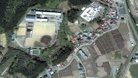
4 3. Tsunami It is usual that an inter-plate earthquake at a trench region is accompanied by a tsunami. Since the magnitude of this earthquake was as large as M9.0, the scale of generated tsunami was also huge. In Japan, large tsunami attacked the Pacific coast ranging from Hokkaido to Okinawa and the tsunami was also observed at the coast of the Japan Sea, the Okhotsk Sea, and the East China Sea. The tsunami also propagated to the coast of Hawaii, northern and southern America continents, and the Pacific countries. At Kamaishi, Ishinomaki, and Ofunato, the first arrival of tsunami was at 14:46, which means that the tsunami reached to these coastal cities at the same time of the earthquake occurrence. The tsunami of maximum height attacked these cities around 15:20, i.e. 30 minutes after the earthquake. Fig. 6 shows the distribution of maximum height of tsunami along the coast around Japan. Heights of more than 8.5m were recorded at Miyako, Iwate Pref., more than 8.0m at Ofunato, Iwate Pref., more than 7.3m at Soma, Fukushima Pref., 4.2m at Oarai, Ibaraki Pref., etc. The Japan Meteorological Agency issued Tsunami Warning (Major tsunami) at 14:49, i.e. 3 minutes after the earthquake, to Iwate, Miyagi, and Fukushima Prefectures. It was extended to Aomori, Ibaraki, and Chiba at 15:14, and was followed by Japan Sea side, Bonin Islands, Sagami Bay, Shizuoka and Wakayama Prefectures. They were in series downgraded to Tsunami Warning (tsunami) and Tsunami Advisory for each region, and were completely cleared on 17:58, March 13. Fig. 6. Tsunami height distribution; a) along the Pacific coast; b) along the Sea of Japan, [1] (heights larger than 5 m are omitted) 4. Damage Given the magnitude of the earthquake and the intensity of ground shaking, the damage brought by the earthquake was also considerable people are either dead or missing, hundreds of thousands are left homeless. The largest damage was brought about by the tsunami which devastated the lowlands of the Pacific coast. The usual damage modes of buildings such as soft first floor collapse were also present, but to a much lesser extent. It is fare to say that damage to buildings was small given the scale of the earthquake. Figs. 7 to 10 show the devastation brought about by the tsunami. On careful inspection of Fig. 9 one can see that the buildings on higher ground are standing, confirming that the damage to buildings was caused by tsunami rather than by strong ground shaking. It still remains to be seen, but probably the most significant damage will prove to be the secondary damage to the reactor of Fukushima I NPP, Fig. 10, where due to a structurally minor damage of the cooling system, the reactor buildings of the NPP were almost brought to a state of meltdown. This led to unplanned power shortages and most importantly, to a release of radioactive substances in the air and in the water. On the optimistic side, the road shown in Fig. 12 is a confirmation of the efficacy of Japan in dealing with disasters. The road was back in operation just 6 days after the earthquake. I - 172

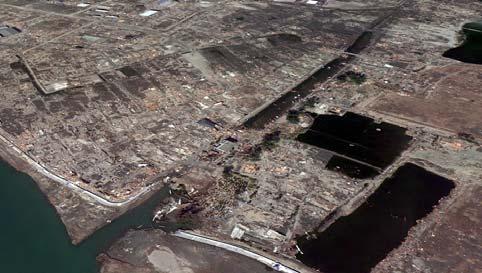
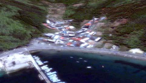
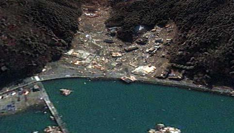
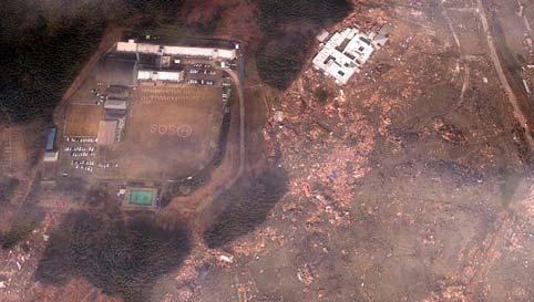
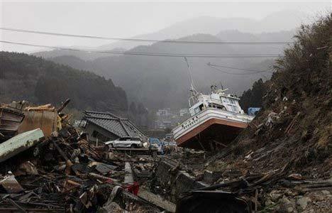
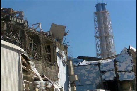
5 Fig. 7. Damage - Sendai neighborhood ( Google) Fig. 8. Damage - Oshika ( Google) Fig. 9. Damage - Minami Sanriku ( Google) Fig. 10. Damage - Ofunato Fig. 11. Damage to Fukushima NPP I - 173


6 Fig. 12. Road repaired six days after the earthquake Conclusions The scale of this earthquake was enormous in terms of magnitude, intensity, and severity of ground shaking. The ensuing damage was also considerable. The devastating tsunami was the main reason for the damage to buildings and facilities. On the optimistic side, the damage attributable to ground shaking was less than expected from such a powerful earthquake. The total number of dead and missing people is high, but given the large area hit by the earthquake, it could have been much worse. In fact, given the circumstances, the human loss may be considered as moderate. The most tragic event was the accident at the Fukushima NPP, where the tsunami disabled the cooling system, resulting in an explosion, uncontrolled release of radioactive material, and ultimately nationwide and indeed worldwide distress. The accident is a clear example of disproportionate damage, and will surely lead to rethinking of the way NPPs are designed, maintained and managed, including the degree of involvement of the private sector in the nuclear power business. This earthquake was not unexpected, given the millennia old record of destructive earthquakes along the Japanese Pacific coast. Regardless of the damage it caused, it will likely not have long lasting adverse effect on the Japanese economy, provided the nuclear accident is contained. REFERENCES [1] NIED, Preliminary report of the 2011 off the Pacific coast of Tohoku Earthquake, [2] NIED, 2011 Off the Pacific Coast of Tohoku earthquake, Strong Ground Motion, I - 174
Coseismic slip model
 Figure 3 - Preliminary highly smoothed model of coseismic slip for the 11 March UCL Institute for Risk & Disaster Reduction Magnitude 9.0 (JMA scale) earthquake Occurred at 02:46:23 pm local time near
REPORT ON THE TOHOKU AREA PASIFIC OFFSHORE EARTHQUAKE
 REPORT ON THE TOHOKU AREA PASIFIC OFFSHORE EARTHQUAKE GENERAL PERSPECTIVE The Highest Magnitude Ever Recorded The 2011 off the Pacific Coast of Tohoku Earthquake (hereafter, the 2011 Tohoku- Pacific Earthquake
Earthquakes and Tsunamis
 Earthquakes and Tsunamis Kenji Satake Earthquake Research Institute University of Tokyo 1 Part I 2011 Tohoku earthquake and tsunami 2 Fukushima Dai ichi NPP accident Earthquake ground motion Reactors automatically
Tohoku-oki event: Tectonic setting
 Tohoku-oki event: Tectonic setting This earthquake was the result of thrust faulting along or near the convergent plate boundary where the Pacific Plate subducts beneath Japan. This map also shows the
Disclaimer. This report was compiled by an ADRC visiting researcher (VR) from ADRC member countries.
 from ADRC member countries.") Disclaimer This report was compiled by an ADRC visiting researcher (VR) from ADRC member countries. The views expressed in the report do not necessarily reflect the views of the ADRC. The boundaries and
Disclaimer This report was compiled by an ADRC visiting researcher (VR) from ADRC member countries. The views expressed in the report do not necessarily reflect the views of the ADRC. The boundaries and
SEISMIC HAZARD ASSESSMENT FOR JAPAN AFTER THE 2011 TOHOKU-OKI MEGA-THRUST EARTHQUAKE (Mw9.0)
") Proceedings of the International Symposium on Engineering Lessons Learned from the 2011 Great East Japan Earthquake, March 1-4, 2012, Tokyo, Japan SEISMIC HAZARD ASSESSMENT FOR JAPAN AFTER THE 2011 TOHOKU-OKI
Proceedings of the International Symposium on Engineering Lessons Learned from the 2011 Great East Japan Earthquake, March 1-4, 2012, Tokyo, Japan SEISMIC HAZARD ASSESSMENT FOR JAPAN AFTER THE 2011 TOHOKU-OKI
The 2011 Tohoku earthquake and dams
 The 2011 Tohoku earthquake and dams N. Matsumoto & T. Sasaki Japan Dam Engineering Center, Japan T. Ohmachi Tokyo Institute of Technology, Japan ABSTRACT: The magnitude 9.0 Tohoku earthquake occurred on
The great earthquakes that have shaped Japan 日本に大きな影響を与えた地震
 The great earthquakes that have shaped Japan 日本に大きな影響を与えた地震 Brian Kennett, Research School of Earth Sciences, ANU Takashi Furumura Earthquake Research Institute, University of Tokyo Japan tectonic plates
Tohoku Earthquake and Tsunami Japan March 11, 2011 Information updated 4/19/2011
 Tohoku Earthquake and Tsunami Japan March 11, 2011 Information updated 4/19/2011 On March 11, 2011 a massive earthquake occurred on the ocean floor south of the northeastern Tohoku region of the Japanese
Seismic Activity and Crustal Deformation after the 2011 Off the Pacific Coast of Tohoku Earthquake
 J-RAPID Symposium March 6-7, 2013 Seismic Activity and Crustal Deformation after the 2011 Off the Pacific Coast of Tohoku Earthquake Y. Honkura Tokyo Institute of Technology Japan Science and Technology
Earthquake Hazards. Tsunami
 Earthquake Hazards Tsunami Review: What is an earthquake? Earthquake is the vibration (shaking) and/or displacement of the ground produced by the sudden release of energy. The point inside the Earth where
Earthquake Hazards. Tsunami
 Earthquake Hazards Tsunami Measuring Earthquakes Two measurements that describe the power or strength of an earthquake are: Intensity a measure of the degree of earthquake shaking at a given locale based
Title. Author(s)Heki, Kosuke. CitationScience, 332(6036): Issue Date Doc URL. Type. File Information. A Tale of Two Earthquakes
Heki, Kosuke. CitationScience, 332(6036): Issue Date Doc URL. Type. File Information. A Tale of Two Earthquakes") Title A Tale of Two Earthquakes Author(s)Heki, Kosuke CitationScience, 332(6036): 1390-1391 Issue Date 2011-06-17 Doc URL http://hdl.handle.net/2115/48524 Type article (author version) File Information
Title A Tale of Two Earthquakes Author(s)Heki, Kosuke CitationScience, 332(6036): 1390-1391 Issue Date 2011-06-17 Doc URL http://hdl.handle.net/2115/48524 Type article (author version) File Information
Earthquake Hazards. Tsunami
 Earthquake Hazards Tsunami Review: What is an earthquake? Earthquake is the vibration (shaking) and/or displacement of the ground produced by the sudden release of energy. The point inside the Earth where
JMA Tsunami Warning Services. Tomoaki OZAKI Senior Coordinator for Tsunami Forecast Modeling Japan Meteorological Agency
 JMA Tsunami Warning Services Tomoaki OZAKI Senior Coordinator for Tsunami Forecast Modeling Japan Meteorological Agency Organization Chart of the Government of Japan Cabinet Office Diet Ministry of Internal
Peter Sammonds Professor of Geophysics
 Peter Sammonds Professor of Geophysics Director, UCL Institute for Risk & Disaster Reduction NERC Strategic Advisor The precautionary principle: Natural hazards and critical infrastructure Acknowledge
The 2011 Tohoku Earthquake and Tsunami Sequence. Mitchell May, EPSC 330
 The 2011 Tohoku Earthquake and Tsunami Sequence Mitchell May, 260556044 EPSC 330 The 2011 earthquake sequence east of Tohoku is classified as a megathrust earthquake off the east coast of Japan. The earthquake
 Title Preliminary report of the 2011 off Earthquake Author(s) Takewaki, Izuru Citation Journal of Zhejiang University SCIE 327-334 Issue Date 2011-05 URL http://hdl.handle.net/2433/159442 RightThe final
Effects of Surface Geology on Seismic Motion
 4 th IASPEI / IAEE International Symposium: Effects of Surface Geology on Seismic Motion August 23 26, 2011 University of California Santa Barbara STRONG MOTION CHARACTERISTICS AND THEIR DAMAGE IMPACT
Correlating Radioactive Material to Sea Surface Temperature off the Coast of Japan: The Fukushima Daiichi Nuclear Disaster. Maya R.
 Correlating Radioactive Material to Sea Surface Temperature off the Coast of Japan: The Fukushima Daiichi Nuclear Disaster Maya R. Pincus Department of Geology, University of Puerto Rico-Mayagüez e-mail:
Magnitude 7.1 PERU. There are early reports of homes and roads collapsed leaving one dead and several dozen injured.
 A magnitude 7.1 earthquake has occurred offshore Peru. The earthquake struck just after 4 a.m. local time and was centered near the coast of Peru, 40 km (25 miles) south-southwest of Acari, Peru at a depth
Basic Analysis on Building Damages by Tsunami due to The 2011 Great East Japan Earthquake Disaster Using GIS
 Basic Analysis on Building Damages by Tsunami due to The 2011 Great East Japan Earthquake Disaster Using GIS Kunihiro Amakuni Pacific Consultants Co. Ltd., Tokyo, Japan Naoto Terazono, Toshio Yamamoto&
The impact of the 2011 off the Pacific coast of Tohoku Earthquake on Tsukuba 32-m station
 7th IVS General Meeting Madrid, Spain March 4-9 2012 The impact of the 2011 off the Pacific coast of Tohoku Earthquake on Tsukuba 32-m station SHINOBU KURIHARA K. Kokado, J. Kuroda, M. Ishihara and R.
2011/3/11 14:46, Depth 24km, M9.0 (JMA)
") Off the Pacific Coast of Tohoku earthquake, Strong Ground Motion /3/ 4:46, Depth 4km, M9. (JMA) Peak Ground Acceleration (surface) Peak Ground Velocity (surface) 45 45 4 4 PGA [gal].. 5... 5... 5....5.
Off the Pacific Coast of Tohoku earthquake, Strong Ground Motion /3/ 4:46, Depth 4km, M9. (JMA) Peak Ground Acceleration (surface) Peak Ground Velocity (surface) 45 45 4 4 PGA [gal].. 5... 5... 5....5.
- Information before strong ground motion -
 -Earthquake Early Warning - Information before strong ground motion - Mitsuyuki HOSHIBA Japan Meteorological Agency January 12, 2007 1 Distribution of Earthquakes Causing Tsunami (1896~2004) in Japan Distribution
JMA Tsunami Warning Services. Takeshi KOIZUMI Senior Coordinator for International Earthquake and Tsunami Information Japan Meteorological Agency
 JMA Tsunami Warning Services Takeshi KOIZUMI Senior Coordinator for International Earthquake and Tsunami Information Japan Meteorological Agency Tectonic Setting of Japan (Headquarters for Earthquake Research
Tsunami waves swept away houses and cars in northern Japan and pushed ships aground.
 Japan was struck by a magnitude 8.9 earthquake off its northeastern coast Friday. This is one of the largest earthquakes that Japan has ever experienced. In downtown Tokyo, large buildings shook violently
RR#8 - Free Response
 Base your answers to questions 1 through 4 on the passage and the map below and on your knowledge of Earth science. The map indicates the epicenter (*) of a major earthquake that occurred at 38 N 142 E.
Special feature: Are its lessons being adequately applied? Follow-up on the ten-year anniversary of the Hanshin-Awaji Earthquake
 Special feature: Are its lessons being adequately applied? Follow-up on the ten-year anniversary of the Hanshin-Awaji Earthquake - Are we prepared for future massive earthquakes? - Hisakazu SAKAI Member
We have previously looked at artificial seismograms such as this one here.
 We have previously looked at artificial seismograms such as this one here. S P A realistic Seismic Record Each vertical line = 1 minute Each horizontal line = 15 minutes Seismic station PMM is in Parkfield,
Strong ground motions from the 2011 off-the Pacific-Coast-of-Tohoku, Japan (Mw=9.0) earthquake obtained from a dense nationwide seismic network
 earthquake obtained from a dense nationwide seismic network") Landslides (2011) 8:333 338 DOI 10.1007/s10346-011-0279-3 Received: 10 June 2011 Accepted: 5 July 2011 Published online: 23 July 2011 The Author(s) 2011. This article is published with open access at Springerlink.com
Landslides (2011) 8:333 338 DOI 10.1007/s10346-011-0279-3 Received: 10 June 2011 Accepted: 5 July 2011 Published online: 23 July 2011 The Author(s) 2011. This article is published with open access at Springerlink.com
Prevention Tsunami wall 10m high (breached by the tsunami due to land level falling by 3m)
") Plate margin Plates Causes Sendai, Japan Convergent plate margin Pacific and Eurasian Plates Convergent plate margin Sima (Pacific plate) moves towards the sial (Eurasian plate) Sima (Pacific plate) is
Plate margin Plates Causes Sendai, Japan Convergent plate margin Pacific and Eurasian Plates Convergent plate margin Sima (Pacific plate) moves towards the sial (Eurasian plate) Sima (Pacific plate) is
Preliminary Analysis for Characteristics of Strong Ground Motion from Gigantic Earthquakes
 Preliminary Analysis for Characteristics of Strong Ground Motion from Gigantic Earthquakes S. Midorikawa, H. Miura Interdisciplinary Graduate School of Science & Engineering, Tokyo Institute of Technology,
EVALUATION OF SITE AMPLIFICATIONS IN JAPAN USING SEISMIC MOTION RECORDS AND A GEOMORPHOLOGIC MAP
 EVALUATION OF SITE AMPLIFICATIONS IN JAPAN USING SEISMIC MOTION RECORDS AND A GEOMORPHOLOGIC MAP Masaki Sakemoto a, Yoshihisa Maruyama b, and Fumio Yamazaki c a Graduate Student, Graduate School of Engineering,
CHAPTER 1 BASIC SEISMOLOGY AND EARTHQUAKE TERMINOLGY. Earth Formation Plate Tectonics Sources of Earthquakes...
 CHAPTER 1 BASIC SEISMOLOGY AND EARTHQUAKE TERMINOLGY Earth Formation... 1-2 Plate Tectonics... 1-2 Sources of Earthquakes... 1-3 Earth Faults... 1-4 Fault Creep... 1-5 California Faults... 1-6 Earthquake
Magnitude 7.1 NEAR THE EAST COAST OF HONSHU, JAPAN
 Japan was rattled by a strong aftershock and tsunami warning Thursday night nearly a month after a devastating earthquake and tsunami flattened the northeastern coast. This earthquake can be considered
Fukushima: What don't we know?
 Fukushima: What don't we know? BY RODNEY C. EWING AND JEROEN RITSEMA 3 MAY 2011 On March 11, when news of the terrible events at the Fukushima Daiichi nuclear power plant began to emerge, so did the contrasts:
Source region of the earthquake
 Disasters of port facilities due to 2011 Great East Japan Earthquake Yoshiaki Kikuchi Port & Airport Research Institute Contents Outline of the earthquake Measured Tsunami height Breakwater disasters by
Case study of Japan: Reference Frames in Practice
 Case study of Japan: Reference Frames in Practice Basara Miyahara and Koji Matsuo Sponsors: 1 Outline Introduction - Geodetic reference frame of Japan - GEONET : continuous GNSS observation system Geometric
PRELIMINARY STUDY OF GROUND MOTION CHARACTERISTICS IN FURUKAWA DISTRICT, JAPAN, BASED ON VERY DENSE SEISMIC-ARRAY-OBSERVATION
 Proceedings of the International Symposium on Engineering Lessons Learned from the 2011 Great East Japan Earthquake, March 1-4, 2012, Tokyo, Japan PRELIMINARY STUDY OF GROUND MOTION CHARACTERISTICS IN
Earthquake Source. Kazuki Koketsu. Special Session: Great East Japan (Tohoku) Earthquake. Earthquake Research Institute, University of Tokyo
 Earthquake. Earthquake Research Institute, University of Tokyo") 2012/9/24 17:20-17:35 WCEE SS24.4 Special Session: Great East Japan (Tohoku) Earthquake Earthquake Source Kazuki Koketsu Earthquake Research Institute, University of Tokyo 1 Names and features of the earthquake
2012/9/24 17:20-17:35 WCEE SS24.4 Special Session: Great East Japan (Tohoku) Earthquake Earthquake Source Kazuki Koketsu Earthquake Research Institute, University of Tokyo 1 Names and features of the earthquake
Unit 9 (packet #2): Volcanoes and Earthquakes
: Volcanoes and Earthquakes") Unit 9 (packet #2): Volcanoes and Earthquakes 13. Earthquakes are one of the most destructive natural forces. I can a. Explain what an earthquake is, where they occur and why they occur. b. Describe the
Unit 9 (packet #2): Volcanoes and Earthquakes 13. Earthquakes are one of the most destructive natural forces. I can a. Explain what an earthquake is, where they occur and why they occur. b. Describe the
The March 11, 2011, Tohoku-oki earthquake (Japan): surface displacement and source modelling
: surface displacement and source modelling") The March 11, 2011, Tohoku-oki earthquake (Japan): surface displacement and source modelling Salvatore Stramondo Bignami C., Borgstrom S., Chini M., Guglielmino F., Melini D., Puglisi G., Siniscalchi V.,
The March 11, 2011, Tohoku-oki earthquake (Japan): surface displacement and source modelling Salvatore Stramondo Bignami C., Borgstrom S., Chini M., Guglielmino F., Melini D., Puglisi G., Siniscalchi V.,
NUMERICAL SIMULATIONS FOR TSUNAMI FORECASTING AT PADANG CITY USING OFFSHORE TSUNAMI SENSORS
 NUMERICAL SIMULATIONS FOR TSUNAMI FORECASTING AT PADANG CITY USING OFFSHORE TSUNAMI SENSORS Setyoajie Prayoedhie Supervisor: Yushiro FUJII MEE10518 Bunichiro SHIBAZAKI ABSTRACT We conducted numerical simulations
Crustal deformation by the Southeast-off Kii Peninsula Earthquake
 Crustal deformation by the Southeast-off Kii Peninsula Earthquake 51 Crustal deformation by the Southeast-off Kii Peninsula Earthquake Tetsuro IMAKIIRE, Shinzaburo OZAWA, Hiroshi YARAI, Takuya NISHIMURA
Indian Ocean Tsunami Warning System: Example from the 12 th September 2007 Tsunami
 Indian Ocean Tsunami Warning System: Example from the 12 th September 2007 Tsunami Charitha Pattiaratchi 1 Professor of Coastal Oceanography, The University of Western Australia Email: chari.pattiaratchi@uwa.edu.au
(energy loss is greater with longer wavelengths)
") GEOL 0820 Ramsey Natural Disasters Spring, 2018 LECTURE #9: Tsunami Monitoring & Mitigation Date: 8 February 2018 I. Characteristics (con t): shoaling: o process of wave height increase and breaking as
GEOL 0820 Ramsey Natural Disasters Spring, 2018 LECTURE #9: Tsunami Monitoring & Mitigation Date: 8 February 2018 I. Characteristics (con t): shoaling: o process of wave height increase and breaking as
Preliminary report of the 2011 off the Pacific coast of Tohoku Earthquake *
 Takewaki / J Zhejiang Univ-Sci A (Appl Phys & Eng) 211 12(5):327-334 327 Journal of Zhejiang University-SCIENCE A (Applied Physics & Engineering) ISSN 1673-565X (Print); ISSN 1862-1775 (Online) www.zju.edu.cn/jzus;
Determining the Earthquake Epicenter: Japan
 Practice Name: Hour: Determining the Earthquake Epicenter: Japan Measuring the S-P interval There are hundreds of seismic data recording stations throughout the United States and the rest of the world.
Earthquakes and Earth s Interior
 - What are Earthquakes? Earthquakes and Earth s Interior - The shaking or trembling caused by the sudden release of energy - Usually associated with faulting or breaking of rocks - Continuing adjustment
KNOWLEDGE NOTE 5-1. Risk Assessment and Hazard Mapping. CLUSTER 5: Hazard and Risk Information and Decision Making. Public Disclosure Authorized
 Public Disclosure Authorized Public Disclosure Authorized Public Disclosure Authorized Public Disclosure Authorized KNOWLEDGE NOTE 5-1 CLUSTER 5: Hazard and Risk Information and Decision Making Risk Assessment
Three Fs of earthquakes: forces, faults, and friction. Slow accumulation and rapid release of elastic energy.
 Earthquake Machine Stick-slip: Elastic Rebound Theory Jerky motions on faults produce EQs Three Fs of earthquakes: forces, faults, and friction. Slow accumulation and rapid release of elastic energy. Three
What Are Disasters? The Rescue Kids Trio!
 The Rescue Kids Trio! What Are Disasters? This manual was made possible through funding by the Council of Local Authorities for International Relations. Disasters and emergency preparedness Emergency preparedness
Widespread Ground Motion Distribution Caused by Rupture Directivity during the 2015 Gorkha, Nepal Earthquake
 Widespread Ground Motion Distribution Caused by Rupture Directivity during the 2015 Gorkha, Nepal Earthquake Kazuki Koketsu 1, Hiroe Miyake 2, Srinagesh Davuluri 3 and Soma Nath Sapkota 4 1. Corresponding
Important Concepts. Earthquake hazards can be categorized as:
 Lecture 1 Page 1 Important Concepts Monday, August 17, 2009 1:05 PM Earthquake Engineering is a branch of Civil Engineering that requires expertise in geology, seismology, civil engineering and risk assessment.
Genpatsu-Shinsai: Catastrophic Multiple Disaster of Earthquake and Quake-induced Nuclear Accident Anticipated in the Japanese Islands
 To the Abstract K. Ishibashi (2003) Genpatsu-Shinsai: Catastrophic Quake and Nuke Disaster Complex IUGG2003 Sappro JSP11 Geophysical Risk and Vulnerability: The Population-Hazard Interaction July 7, Mon.,14:30
The EEFIT Mission to Japan after the M W 9.0 Tōhoku Earthquake: Key Findings and Lessons Learned
 The EEFIT Mission to Japan after the M W 9.0 Tōhoku Earthquake: Key Findings and Lessons Learned By A. Pomonis (Team Leader) Director, Cambridge Architectural Research, Ltd. on behalf of the EEFIT Mission
Outline of the 2011 off the Pacific coast of Tohoku Earthquake (M w 9.0) Earthquake Early Warning and observed seismic intensity
 Earthquake Early Warning and observed seismic intensity") LETTER Earth Planets Space, 63, 547 551, 2011 Outline of the 2011 off the Pacific coast of Tohoku Earthquake (M w 9.0) Earthquake Early Warning and observed seismic intensity Mitsuyuki Hoshiba 1, Kazuhiro
LETTER Earth Planets Space, 63, 547 551, 2011 Outline of the 2011 off the Pacific coast of Tohoku Earthquake (M w 9.0) Earthquake Early Warning and observed seismic intensity Mitsuyuki Hoshiba 1, Kazuhiro
Lessons Learned from Past Tsunamis Warning and Emergency Response
 UNESCO IOC CTIC US NOAA ITIC Regional Training Workshop on Strengthening Tsunami Warning and Emergency Response Standard Operating Procedures and the Development of the ICG/CARIBE-EWS PTWC New Enhanced
Running Head: JAPANESE TSUNAMI 1. Geological Perspective of the Japanese Tsunami
 Running Head: JAPANESE TSUNAMI 1 Geological Perspective of the Japanese Tsunami JAPANESE TSUNAMI 2 JAPANESE TSUNAMI 3 Abstract Humanity is characterized with flaws, so is planet earth. Earthquakes shake
Damage Estimation of the Road Bridge Structure Using the Seismic Hazard map for BCM in Hokkaido, Japan
 Damage Estimation of the Road Bridge Structure Using the Seismic Hazard map for BCM in Hokkaido, Japan T. Sato & H. Nishi Civil Engineerring Research Institute for Cold Region, PWRI,Japan T. Ikeda & Y.
Making the Original Earthquake Early Warning System including epicentral earthquake
 Making the Original Earthquake Early Warning System including epicentral earthquake Protecting your life and minimizing damage. TEL: 0742-53-7833 4F, Oshikuma-cho 557-7, Nara-City 631-0011, Japan URL http://www.jjjnet.com
Earthquakes and seismic hazard in Sweden
 Earthquakes and seismic hazard in Sweden Björn Lund, Roland Roberts & Reynir Bödvarsson Uppsala University Outline Nordic and Swedish seismicity Comparison to plate boundary seismicity in Japan. Extrapolation
Earthquakes and Tsunamis
 Earthquakes and Tsunamis Disaster prevention and mitigation efforts Japan Meteorological Agency Introduction Introduction Japan an earthquake-prone country Earthquake/Tsunami Monitoring and Flow of Warnings/Information
Checking of Seismic and Tsunami Hazard for Coastal NPP of Chinese Continent
 Checking of Seismic and Tsunami Hazard for Coastal NPP of Chinese Continent Chang Xiangdong (Nuclear and Radiation Safety Center, MEP, China) 2012.Sep 1. Introduction After Japanese Fukushima nuclear accident
LAB: PLATE TECTONICS GOAL: Calculate rates of plate movement
 Name LAB: PLATE TECTONICS GOAL: Calculate rates of plate movement Rates of plate movement are calculated by measuring the distance rocks have moved since they formed. Rates are expressed in cm per year
NUMERICAL SIMULATION OF TSUNAMI PROPAGATION AND INUNDATION ALONG THE RAKHINE COAST AREAS IN MYANMAR
 NUMERICAL SIMULATION OF TSUNAMI PROPAGATION AND INUNDATION ALONG THE RAKHINE COAST AREAS IN MYANMAR Su Hninn Htwe Supervisor: Bunichiro SHIBAZAKI MEE12619 Yushiro FUJII ABSTRACT This study aimed to assess
Earthquakes Physical Geology 2017 Part 1: Exploring Earthquake distributions. Home butto California Earthquakes: 1) 2) 3) above
 2) 3) above") Earthquakes Physical Geology 2017 Adapted from a lab by Jennifer Wenner This lab is designed to give you experience exploring seismicity associated with different plate boundaries. You will examine seismograms
Earthquakes Physical Geology 2017 Adapted from a lab by Jennifer Wenner This lab is designed to give you experience exploring seismicity associated with different plate boundaries. You will examine seismograms
Blank line 10 pt Keywords: Response Characteristics, Skyscraper, Tohoku-Oki earthquake, Natural operiod
 A Study on the Response Characteristics of a High-Rise Building Built on the Reclaimed Land along the Osaka Bay Yuta Akizuki Graduate School of Engineering, Kyoto University, Kyoto, Japan Blank Line 9
4 Associate Professor, DPRI, Kyoto University, Uji, Japan
 Proceedings of the International Symposium on Engineering Lessons Learned from the 2 Great East Japan Earthquake, March -4, 22, Tokyo, Japan STRONG MOTION ESTIMATION AT THE ELEVATED BRIDGES OF THE TOHOKU
Magnitude 7.0 N of ANCHORAGE, ALASKA
 A magnitude 7.0 earthquake occurred just before 8:30 am local time 8 miles north of Anchorage at a depth of 40.9 km (25.4 miles). There are reports of major infrastructure damage and damage to many homes
Magnitude 7.7 QUEEN CHARLOTTE ISLANDS REGION
 A major 7.7 magnitude earthquake struck at 8:04 PM local time in western British Columbia, Canada. The epicenter is located on Moresby Island, the southern large island in the Queen Charlotte Islands region.
2. Tsunami Source Details
 2. Tsunami Source Details The Northland area faces a range of potential tsunamigenic sources that include several local and distant fault systems and underwater landslides. A NIWA study (Goff et al. 2006)
Magnitude 6.5 OFFSHORE NORTHERN CALIFORNIA
 A powerful offshore earthquake that struck near the Northern California coast left a hodgepodge of debris for communities to sort through Sunday but spared residents any serious injury. After 25,000 people
STRONG GROUND MOTION ATTENUATION IN THE SEA OF JAPAN (OKHOTSK-AMUR PLATES BOUNDARY) REGION
 REGION") 13 th World Conference on Earthquake Engineering Vancouver, B.C., Canada August 1-6, 2004 Paper No. 197 STRONG GROUND MOTION ATTENUATION IN THE SEA OF JAPAN (OKHOTSK-AMUR PLATES BOUNDARY) REGION Laxman
13 th World Conference on Earthquake Engineering Vancouver, B.C., Canada August 1-6, 2004 Paper No. 197 STRONG GROUND MOTION ATTENUATION IN THE SEA OF JAPAN (OKHOTSK-AMUR PLATES BOUNDARY) REGION Laxman
Frequency-dependent Strong Motion Duration Using Total Threshold Intervals of Velocity Response Envelope
 Proceedings of the Tenth Pacific Conference on Earthquake Engineering Building an Earthquake-Resilient Pacific 6-8 November 015, Sydney, Australia Frequency-dependent Strong Motion Duration Using Total
Analysis of Ignitions Following 2011 Tohoku Earthquake Using Kawasumi Model DRAFT
 Analysis of Ignitions Following 211 Tohoku Earthquake Using Kawasumi Model KEISUKE HIMOTO 1, MASUMI YAMADA 1, and TOMOAKI NISHINO 2 1 Disaster Prevention Research Institute, Kyoto University Gokasho, Uji,
Recent Progress of Seismic Observation Networks in Japan
 Journal of Physics: Conference Series Recent Progress of Seismic Observation Networks in Japan To cite this article: Y Okada 2013 J. Phys.: Conf. Ser. 433 012039 Related content - Physical applications
Earthquake Investigation
 Exploration A Earthquake Investigation 1. Obtain a piece of plastic putty and knead it into a rectangular shape. 2. Push the ends of the putty toward the middle. Draw and describe what it looks like below.
LETTER Earth Planets Space, 56, , 2004
 LETTER Earth Planets Space, 56, 353 357, 2004 Deep seismic activities preceding the three large shallow earthquakes off south-east Hokkaido, Japan the 2003 Tokachi-oki earthquake, the 1993 Kushiro-oki
The map below shows the locations of earthquakes and volcanoes
 45 Understanding Plate Boundaries R E A D I N G The map below shows the locations of earthquakes and volcanoes on the earth s surface. Today, many of the world s most active volcanoes are located around
NUMERICAL SIMULATION AS GUIDANCE IN MAKING TSUNAMI HAZARD MAP FOR LABUAN ISLAND
 NUMERICAL SIMULATION AS GUIDANCE IN MAKING TSUNAMI HAZARD MAP FOR LABUAN ISLAND MOHD RIDZUAN bin Adam Supervisor: Fumihiko IMAMURA MEE09199 ABSTRACT At the northeast end of the South China Sea, tsunamis
4 Deforming the Earth s Crust
 CHAPTER 7 4 Deforming the Earth s Crust SECTION Plate Tectonics BEFORE YOU READ After you read this section, you should be able to answer these questions: What happens when rock is placed under stress?
Hazards in the Seattle Area. Disaster Questions. Where Were You? Where Were You? Volcanoes St. Helens Adams, Rainier, Glacier, Baker
 Hazards in the Seattle Area Volcanoes St. Helens Adams, Rainier, Glacier, Baker Earthquakes Outer coast Puget Sound (Seattle Fault & others) Tsunami Outer coast Puget Sound (Seattle Fault & others) Disaster
Groundwater changes related to the 2011 Off the Pacific Coast of Tohoku Earthquake (M9.0)
") Groundwater changes related to the 2011 Off the Pacific Coast of Tohoku Earthquake (M9.0) Yuichi Kitagawa Senior Research Scientist, AIST, GSJ, Active Fault and Earthquake Research Cente Naoji Koizumi
Groundwater changes related to the 2011 Off the Pacific Coast of Tohoku Earthquake (M9.0) Yuichi Kitagawa Senior Research Scientist, AIST, GSJ, Active Fault and Earthquake Research Cente Naoji Koizumi
9.3. Earthquakes. Earthquakes at Divergent Boundaries
 9.3 Earthquakes Preview the headings on these two pages. What can you say about where earthquakes occur? As the plates that make up Earth s crust move, the rough edges lock together. Over time, pressure
APPLICATON OF SEAMLESS SIMULATION OF SEISMIC RESPONSE ANALYSIS AND HIGH RESOLUTION TSUNAMI SIMULATION TO COASTAL AREA OF SENDAI
 Proceedings of the International Symposium on Engineering Lessons Learned from the 2011 Great East Japan Earthquake, March 1-4, 2012, Tokyo, Japan APPLICATON OF SEAMLESS SIMULATION OF SEISMIC RESPONSE
Tectonic Plates Lexile 840L
 6.10: Tectonic Plates Tectonic Plates Lexile 840L 1 On March 11, 2011, an earthquake measuring 8.9 on the Richter scale rocked the sea floor. It made a giant wave, which grew as tall as 30 feet (9.14 meters)
GEOPHYSICAL RESEARCH LETTERS, VOL. 31, L19604, doi: /2004gl020366, 2004
 GEOPHYSICAL RESEARCH LETTERS, VOL. 31, L19604, doi:10.1029/2004gl020366, 2004 Characteristic seismic activity in the subducting plate boundary zone off Kamaishi, northeastern Japan, revealed by precise
Complicated repeating earthquakes on the convergent plate boundary: Rupture processes of the 1978 and 2005 Miyagi-ken Oki earthquakes
 Complicated repeating earthquakes on the convergent plate boundary: Rupture processes of the 1978 and 2005 Miyagi-ken Oki earthquakes Changjiang Wu 1 and Kazuki Koketsu Earthquake Research Institute, University
10th International Workshop on Seismic Microzoning and Risk Reduction September 25, 2013,Tokyo, Japan
 1th International Workshop on Seismic Microzoning and Risk Reduction September 25, 213,Tokyo, Japan National Graduate Institute for Policy Studies (GRIPS), Roppongi, Tokyo Some features of strong ground
Earthquakes Chapter 19
 Earthquakes Chapter 19 Does not contain complete lecture notes. What is an earthquake An earthquake is the vibration of Earth produced by the rapid release of energy Energy released radiates in all directions
Revision of the AESJ Standard for Seismic Probabilistic Risk Assessment (2) Seismic Hazard Evaluation
 Seismic Hazard Evaluation") Revision of the AESJ Standard for Seismic Probabilistic Risk Assessment (2) Seismic Hazard Evaluation Katsumi Ebisawa a, Katsuhiro Kamae b, Tadashi Annaka c, Hideaki Tsutsumi d And Atsushi Onouchi e a
Revision of the AESJ Standard for Seismic Probabilistic Risk Assessment (2) Seismic Hazard Evaluation Katsumi Ebisawa a, Katsuhiro Kamae b, Tadashi Annaka c, Hideaki Tsutsumi d And Atsushi Onouchi e a
Tsunami. Harry Yeh Oregon State University. Eastern Japan Earthquake Disaster Briefing at PEER: April 28, 2011
 Tsunami by Harry Yeh Oregon State University Eastern Japan Earthquake Disaster Briefing at PEER: April 28, 2011 Seismic Characteristics Rupture Model (Harvard Seismology) The fault rupture process was
Earthquakes. Building Earth s Surface, Part 2. Science 330 Summer What is an earthquake?
 Earthquakes Building Earth s Surface, Part 2 Science 330 Summer 2005 What is an earthquake? An earthquake is the vibration of Earth produced by the rapid release of energy Energy released radiates in all
Annual Report for Research Work in the fiscal year 2005
 JST Basic Research Programs C R E S T (Core Research for Evolutional Science and Technology) Annual Report for Research Work in the fiscal year 2005 Research Area : High Performance Computing for Multi-scale
Magnitude 7.9 SE of KODIAK, ALASKA
 A magnitude 7.9 earthquake occurred at 12:31 am local time 181 miles southeast of Kodiak at a depth of 25 km (15.5 miles). There are no immediate reports of damage or fatalities. Light shaking from this
"The Big One" by sea and not by land
 "The Big One" by sea and not by land By Los Angeles Times, adapted by Newsela staff on 03.24.14 Word Count 629 Surfer Lee Johnson emerges from the water at San Onofre State Beach, Calif., with the twin
Cascadia Seismic Event Planning for the Maritime Community
 Cascadia Seismic Event Planning for the Maritime Community Jonathan Allan, Oregon Dept. of Geology and Mineral Industries Presentation to Annual Pacific Northwest Waterways Association Meeting (PNWA) October
Multi-planar structures in the aftershock distribution of the Mid Niigata prefecture Earthquake in 2004
 LETTER Earth Planets Space, 57, 411 416, 2005 Multi-planar structures in the aftershock distribution of the Mid Niigata prefecture Earthquake in 2004 Shigeki Aoki 1, Masaki Nishi 2, Koji Nakamura 2, Tetsuo