We have previously looked at artificial seismograms such as this one here.
|
|
|
- Ariel Webb
- 5 years ago
- Views:
Transcription

1 We have previously looked at artificial seismograms such as this one here. S P
 PDT = Pacific daylight time S - P = 9 min 30 sec =")
2 A realistic Seismic Record Each vertical line = 1 minute Each horizontal line = 15 minutes Seismic station PMM is in Parkfield, California UTC = Universal standard time (Greenwich, England) PDT = Pacific daylight time S - P = 9 min 30 sec = 570 seconds
3 Liquefaction Some rocks behave as liquids when shaken by earthquake waves (soft sands, clays, water-logged sediments, land-fill). Such materials are known as thixotropic. The process is called liquefaction. Liquefaction magnifies the effects of earthquakes. It results in ground movement, slumping and landslides, causing buildings to collapse. It is a very serious contributor to earthquake damage.

4 Landslide at Turnagain Heights, Alaska, 1964 A very good example of liquefaction
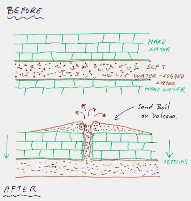
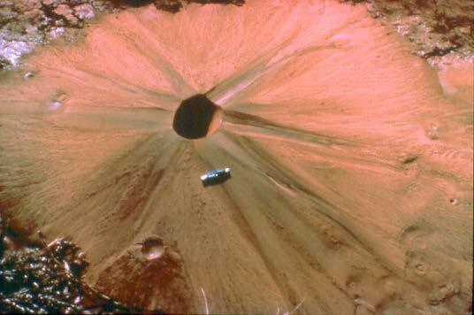
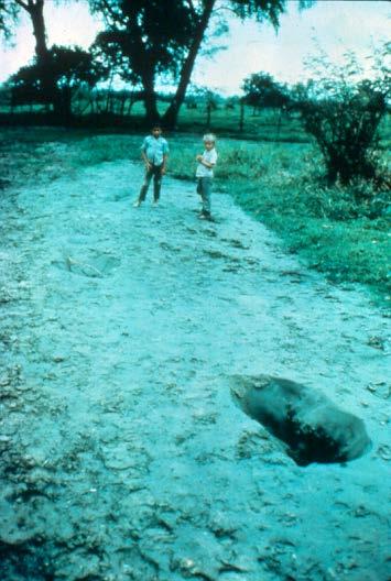
5 Liquefaction Sand Boils Examples of sand boils

6 Tsunamis The great wave off the coast of Kanagawa a famous picture by the Japanese artist Hokusai ( )
7 What on Earth is a Tsunami? Tsunami (Japanese) means harbor wave. Tidal Wave (English) is not strictly correct, since tides imply the influence of the moon. Tsunamis are mostly generated along, or close to, the deep ocean trenches of the Pacific Ocean. They are caused by:- Faulting (earthquakes) Landslides Volcanic eruptions

8 Generation of a Tsunami by Faulting It is mostly reverse faults that trigger tsunamis
9 Tsunami Notice how the wave height increases as it approaches the shore. Wave heights are typically between 8 to 40 feet (100 ft waves have been recorded). Wave heights can be amplified by the coastline. The interval between waves can vary from minutes to hours. The speed of the waves is proportional to the water depth, and therefore decreases as it approaches the shore.
10 Example of changes in water level associated with a small tsunami at Hilo, Hawaii in 1975.
11 Calculating the Tsunami Wave Speed


12 Damage caused by Tsunamis Before After Scotch Cap lighthouse, Aleutian Islands was completely destroyed by a tsunami following an earthquake in the Aleutian islands in The lighthouse was 40 ft above the water, but the tsunami produced 100 ft waves!


13 The same 1946 Aleutian Island earthquake produced a tsunami that traveled 3,800 miles across the Pacific Ocean, devastating Hilo on the Big Island of Hawaii ft waves coming ashore in Hilo

14 Tsunami breaking over the pier in Hilo, Hawaii $26 million in damage, 159 deaths

15 Hilo, Hawaii, 1946 Waterfront buildings were washed across the street crashing into other buildings.

16 Hilo, Hawaii 1960 Once again, in 1960, Hilo was devastated by a tsunami. This one originated in Chile, 10,000 miles away!


17 Japan, 1983 Initial phase water withdraws Flooding $800 million damage 104 people drowned Afterwards


18 Valdez, Alaska, 1964 Earthquake caused land to slide into the sea, carrying dock and part of town with it. Tsunami with 32 ft. waves followed. $150 million in damage and 30 deaths.

19 Sumatran Earthquake and Tsunami December 26 th, 2004 Megathrust along subduction zone between Australian plate and Burma and Sunda microplates km long displacement zone, most of which occurred 500 km N.W. of epicenter. Maximum of 20 m displacement Magnitude 9.0 Fourth largest earthquake since 1900 A.D. and largest since 1964 Alaska earthquake. Equivalent to 475 megatons of TNT (23,000 Nagasaki A-bomb). Triggered a massive tsunami
. Travel Times India ~ 2 hours E.")
20 Tsunami traveled across entire Indian Ocean, affecting Indonesia, Malaysia, Thailand, India, Sri Lanka, Maldives, Somalia, Madagascar and Tanzania. Maximum wave height was about 25 m (80 ft). Travel Times India ~ 2 hours E. Africa ~ 7 hours


21 Wave coming ashore at holiday resort in Malasia Vegetation stripped from low-lying areas by waves


22 The worst hit area was Banda Aceh in N. Sumatra, Indonesia

23 Tsunami Warning System Times taken for tsunamis to reach Hawaii from certain locations The tsunami warning system was established in 1946 following a devastating tsunami in Hawaii. Pacific Ocean-wide network of:- Seismic Station Tsunami Buoys Coastguards Civil defense

24 Tsunami Buoys in the Pacific These buoys measure changes in water depth, thereby indicating the passing of tsunami waves. Following the 1996 Sumatran earthquake and tsunami, there are plans to increase the number of tsunami warning buoys in the Pacific and Indian oceans


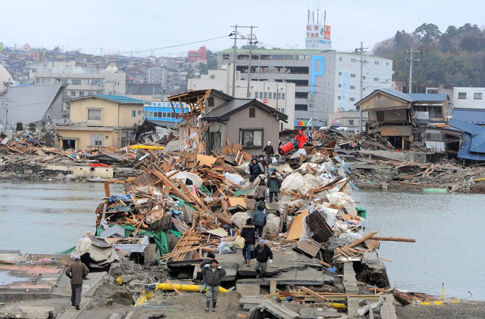
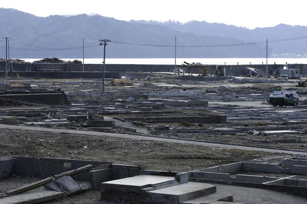
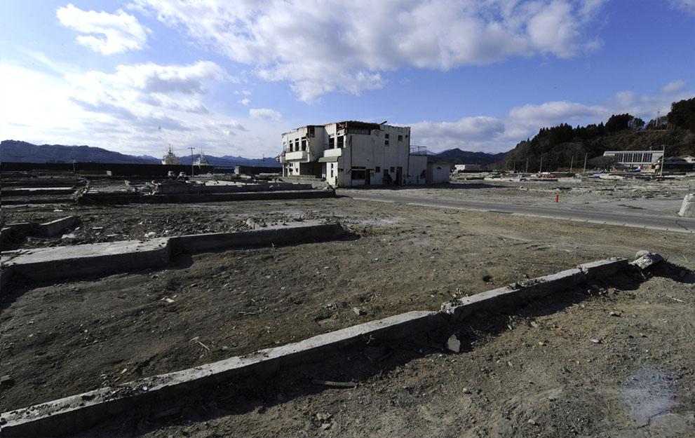
25 Japanese Earthquake and Tsunami March 11, 2011 Magnitude = 9.0 CONSEQUENCES Affected 804 km of east coast Inundated 130 sq. km of land Dead ~ 15,854 Missing ~ 3,272 Homeless ~ 131,000 Economic Loss ~$309 billion PBS Nova Video
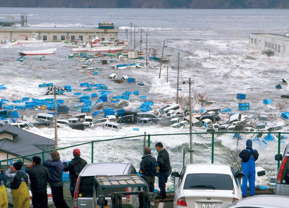
26 Miyako
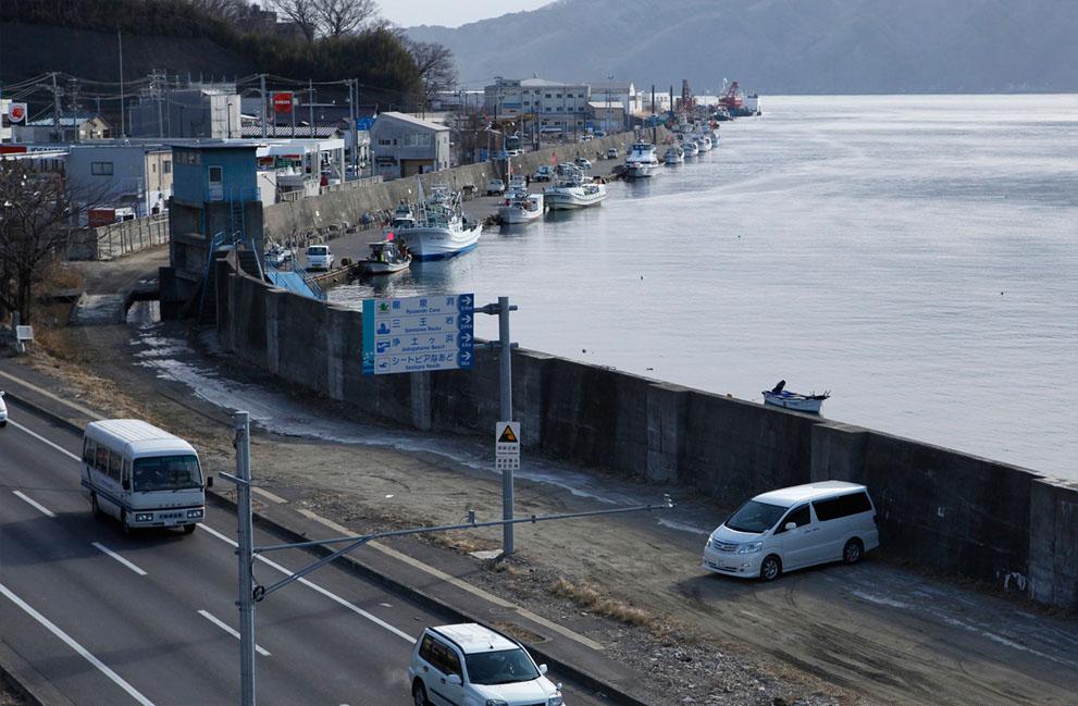
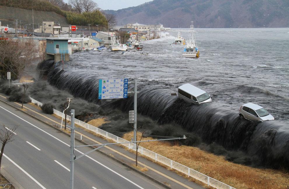
27 Miyako
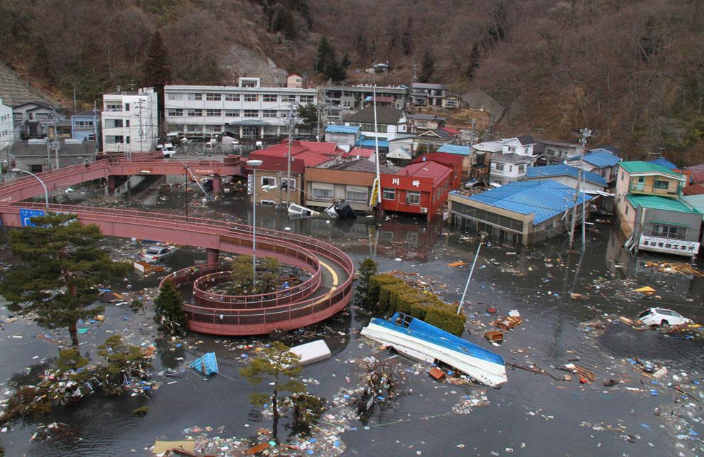
28 Miyako


29 Kessennuma

30 Ishinomaki
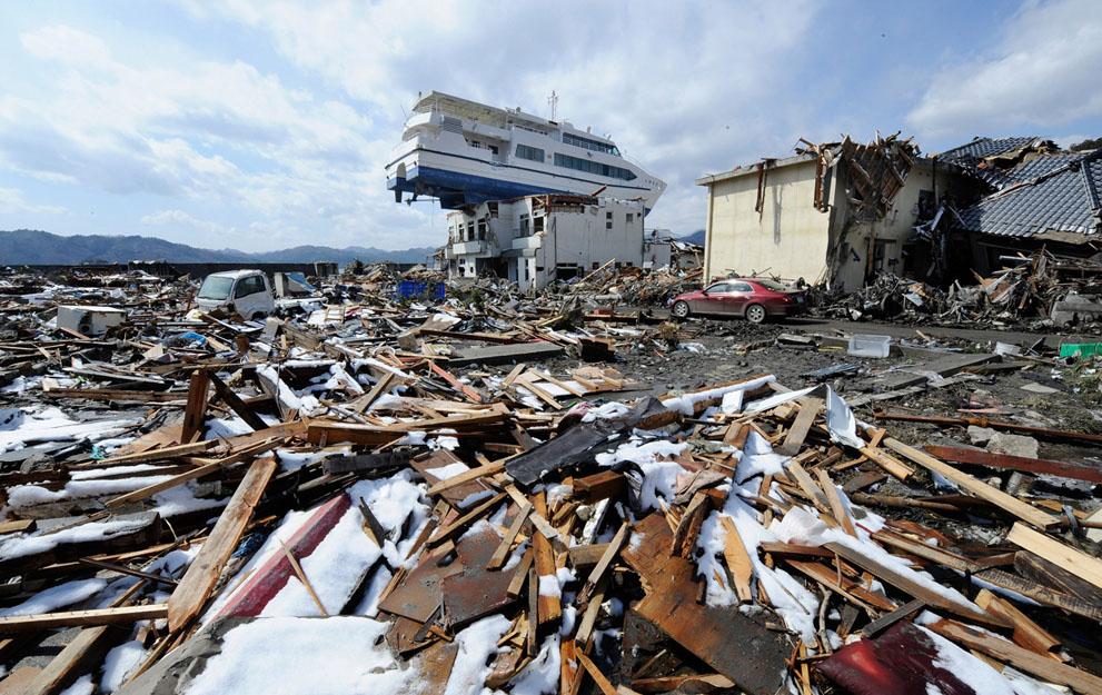
31 Ostuchi
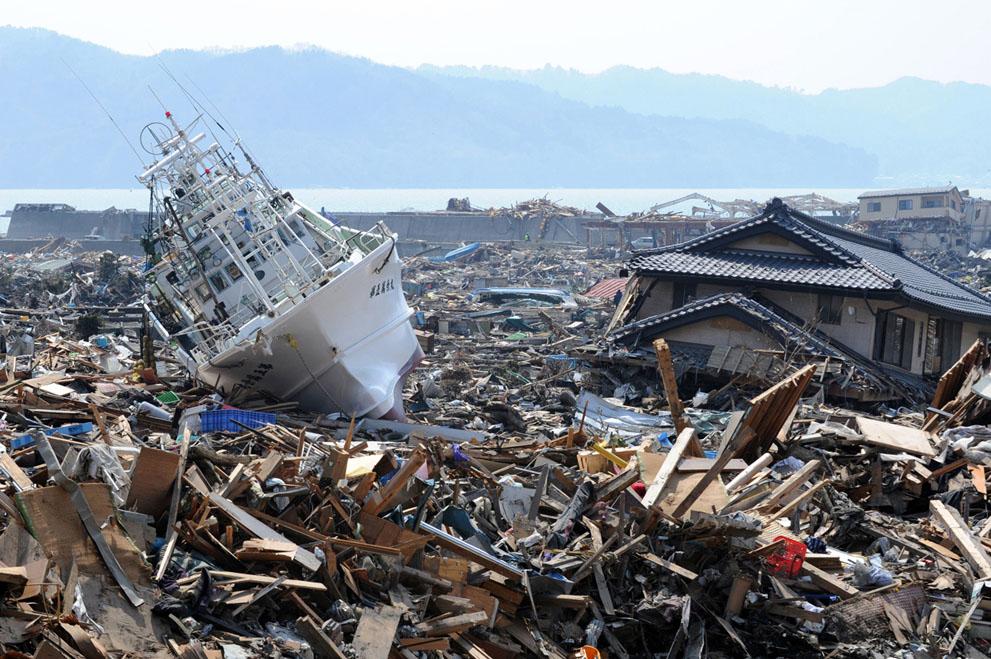
32 Ostuchi
Earthquake Hazards. Tsunami
 Earthquake Hazards Tsunami Review: What is an earthquake? Earthquake is the vibration (shaking) and/or displacement of the ground produced by the sudden release of energy. The point inside the Earth where
Earthquake Hazards. Tsunami
 Earthquake Hazards Tsunami Measuring Earthquakes Two measurements that describe the power or strength of an earthquake are: Intensity a measure of the degree of earthquake shaking at a given locale based
Earthquake Hazards. Tsunami
 Earthquake Hazards Tsunami Review: What is an earthquake? Earthquake is the vibration (shaking) and/or displacement of the ground produced by the sudden release of energy. The point inside the Earth where
(energy loss is greater with longer wavelengths)
") GEOL 0820 Ramsey Natural Disasters Spring, 2018 LECTURE #9: Tsunami Monitoring & Mitigation Date: 8 February 2018 I. Characteristics (con t): shoaling: o process of wave height increase and breaking as
GEOL 0820 Ramsey Natural Disasters Spring, 2018 LECTURE #9: Tsunami Monitoring & Mitigation Date: 8 February 2018 I. Characteristics (con t): shoaling: o process of wave height increase and breaking as
Tsunami Seismic Sea Wave. Dr. Wan Zuhairi Wan Yaacob Program Geologi, UKM
 Tsunami Seismic Sea Wave soo-nah-mee Dr. Wan Zuhairi Wan Yaacob Program Geologi, UKM the breaking wave off Kanagawa wood block color print the event s surface wave magnitude, Ms. Historical map of 731
Earthquakes 11/14/2014. Earthquakes Occur at All Boundaries. Earthquakes. Key Aspects of an Earthquake. Epicenter. Focus
 Earthquakes Earthquakes Caused by friction and movement between Earth s tectonic plates A release of force Often caused by a catch between two plates As plates slide by, they stick to each other When the
Disclaimer. This report was compiled by an ADRC visiting researcher (VR) from ADRC member countries.
 from ADRC member countries.") Disclaimer This report was compiled by an ADRC visiting researcher (VR) from ADRC member countries. The views expressed in the report do not necessarily reflect the views of the ADRC. The boundaries and
Disclaimer This report was compiled by an ADRC visiting researcher (VR) from ADRC member countries. The views expressed in the report do not necessarily reflect the views of the ADRC. The boundaries and
2.3 Notes: Earthquake Damage Can Be Reduced
 2.3 Notes: Earthquake Damage Can Be Reduced Earthquakes can cause severe damage and loss of life Each year, there is about one earthquake with a magnitude of or higher-this is an extremely earthquake.
COMING TO A SHORELINE NEAR YOU? Not Your Ordinary Wave
 COMING TO A SHORELINE NEAR YOU? Modelling of the lost tsunami of 8000 yr BP* Not Your Ordinary Wave * yr BP means radiocarbon years before 1950 Lost tsunami ~ 8,000 yr B.P. The tsunami was triggered by
Introduction to Environmental Geology, 5e Case History: Indonesian Tsunami Indonesian Tsunami (2) Introduction Historic Tsunamis
 Introduction Historic Tsunamis") 1 2 3 4 5 6 7 8 9 Introduction to Environmental Geology, 5e Chapter 7 Tsunami Case History: Indonesian Tsunami December 26, 2004, within a few hours, close to 250,000 people were killed With no warning
1 2 3 4 5 6 7 8 9 Introduction to Environmental Geology, 5e Chapter 7 Tsunami Case History: Indonesian Tsunami December 26, 2004, within a few hours, close to 250,000 people were killed With no warning
Introduction to Environmental Geology, 5e
 Lecture Presentation prepared by X. Mara Chen, Salisbury University Introduction to Environmental Geology, 5e Edward A. Keller Chapter 7 Tsunami Case History: Indonesian Tsunami December 26, 2004, within
Chapter 4 Earthquakes and Tsunamis
 Geology of the Hawaiian Islands Class 21 30 March 2004 100 100 100 96 A B C D F Exam Scores 95 94 94 90 85 83 83 83 Mean 72 67 61 59 59 55 54 41 Mean = 78.5 Median = 83 Any Questions? Chapter 4 Earthquakes
Chapter 4 Earthquakes and Tsunamis. Geology of the Hawaiian Islands. Any Questions? Class March Mean = 78.
 Geology of the Hawaiian Islands Class 21 30 March 2004 Any Questions? 100 100 100 96 A B C D F Exam Scores 95 94 94 90 85 83 83 83 Mean 72 67 61 59 59 55 54 41 Mean = 78.5 Median = 83 Chapter 4 Earthquakes
Earthquakes Physical Geology 2017 Part 1: Exploring Earthquake distributions. Home butto California Earthquakes: 1) 2) 3) above
 2) 3) above") Earthquakes Physical Geology 2017 Adapted from a lab by Jennifer Wenner This lab is designed to give you experience exploring seismicity associated with different plate boundaries. You will examine seismograms
Earthquakes Physical Geology 2017 Adapted from a lab by Jennifer Wenner This lab is designed to give you experience exploring seismicity associated with different plate boundaries. You will examine seismograms
Indian Ocean Tsunami Warning System: Example from the 12 th September 2007 Tsunami
 Indian Ocean Tsunami Warning System: Example from the 12 th September 2007 Tsunami Charitha Pattiaratchi 1 Professor of Coastal Oceanography, The University of Western Australia Email: chari.pattiaratchi@uwa.edu.au
Tsunamis. Visit for thousands of books and materials. A Reading A Z Level S Leveled Reader Word Count: 889
 Tsunamis A Reading A Z Level S Leveled Reader Word Count: 889 LEVELED READER S Written by Shaun Taylor Visit www.readinga-z.com for thousands of books and materials. www.readinga-z.com Photo Credits: Front
RR#8 - Free Response
 Base your answers to questions 1 through 4 on the passage and the map below and on your knowledge of Earth science. The map indicates the epicenter (*) of a major earthquake that occurred at 38 N 142 E.
Effects of Earthquakes
 Effects of Earthquakes Fire resulting from Northridge earthquake, 1994 Tusnami aftermath. Banda Aceh, Sumatra, December 26, 2004 Effects of Earthquakes Ways in which earthquakes cause damage Shaking Fault
What causes a tsunami?
 Listen: Have this page read to you [1] Have this page read to you [2] A tsunami is a series of waves in the sea caused by a movement on the sea floor. New Zealand is at risk from tsunami because it has
Tsunami! Beyond the Book. FOCUS Book
 FOCUS Book Use the engineering design process to design a structure that will protect a coastal town from possible tsunami damage. Brainstorm design ideas for your structure with a group of classmates.
Three Fs of earthquakes: forces, faults, and friction. Slow accumulation and rapid release of elastic energy.
 Earthquake Machine Stick-slip: Elastic Rebound Theory Jerky motions on faults produce EQs Three Fs of earthquakes: forces, faults, and friction. Slow accumulation and rapid release of elastic energy. Three
Name: Date: Bell: The Sumatra Earthquake and Tsunami December 26, 2004
 Name: Date: Bell: The Sumatra Earthquake and Tsunami December 26, 2004 Introduction: The incredible damage and tragic loss of life resulting from the 9.0 magnitude earthquake and ensuing tsunami was shocking
Unit 7: Dynamic Planet: Earthquakes & Volcanoes
 Unit 7: Dynamic Planet: Earthquakes & Volcanoes Lecture 3 Objectives: E3.4C - Describe the effects of earthquakes and volcanic eruptions on humans. E3.4f - Explain why fences are offset after an earthquake
Preparation for Future Earthquake and Tsunami Hazards: Lessons Learned from the 2004 Sumatra-Andaman Earthquake and the Asian Tsunami
 First International Conference of Aceh and Indian Ocean Studies Organized by Asia Research Institute, National University of Singapore & Rehabilitation and Construction Executing Agency for Aceh and Nias
The Indian Ocean. Copyright 2010 LessonSnips
 The Indian Ocean One of the five major geographic divisions of the world s ocean, the Indian Ocean is located in the Eastern Hemisphere. The Indian Ocean is bounded by three continents: Africa to the west,
Not all eruptions are the same. Sometimes, there is a huge explosion. The hot magma shoots
 Natural Disasters A natural disaster is an event that happens in nature. It is an event that can cause a lot of damage. Volcanoes, earthquakes, and tsunamis are all natural disasters. Volcanoes A volcano
Geology Topics. Unit 6 Notes
 Geology Topics Unit 6 Notes Composition of the Earth Earth is layered due to density differences. Crust thin outer layer, solid, made up of continental and oceanic crust Mantle rocky layer below the crust
Lessons from the 2004 Sumatra earthquake and the Asian tsunami
 Lessons from the 2004 Sumatra earthquake and the Asian tsunami Kenji Satake National Institute of Advanced Industrial Science and Technology Outline 1. The largest earthquake in the last 40 years 2. Tsunami
VIDEO The 2011 Japanese Earthquake and Tsunami
 VIDEO The 2011 Japanese Earthquake and Tsunami Why was it so large and devastating? Why so short a warning? Why did tsunami precautions fail? What happened elsewhere? The Loma Prieta Earthquake (1989)
Earthquakes & Volcanoes
 Earthquakes & Volcanoes Geology - the study of solid Earth, the rocks of which it is composed, and the processes by which they change geo = Earth; ology = study of Earth s Layers Plate Tectonics - the
News Release December 30, 2004 The Science behind the Aceh Earthquake
 News Release December 30, 2004 The Science behind the Aceh Earthquake PASADENA, Calif. - Kerry Sieh, the Robert P. Sharp Professor of Geology at the California Institute of Technology and a member of Caltech's
12.2 Plate Tectonics
 12.2 Plate Tectonics LAYERS OF THE EARTH Earth is over 1200 km thick and has four distinct layers. These layers are the crust, mantle (upper and lower), outer core, and inner core. Crust outer solid rock
Dynamic Crust Practice
 1. Base your answer to the following question on the cross section below and on your knowledge of Earth science. The cross section represents the distance and age of ocean-floor bedrock found on both sides
What causes tsunamis?
 What causes tsunamis? Any movement/displacement of the ocean floor can generate the energy that forms a tsunami. However, tsunamis are usually generated by large, shallow earthquakes, which have epicenters
LOCAL TSUNAMIS: CHALLENGES FOR PREPAREDNESS AND EARLY WARNING
 LOCAL TSUNAMIS: CHALLENGES FOR PREPAREDNESS AND EARLY WARNING HARALD SPAHN 1 1 German Technical Cooperation International Services, Jakarta, Indonesia ABSTRACT: Due to the threat of local tsunamis warning
What is an earthquake?
 Earthquakes Definitions Seismology The study of earthquakes dates back almost 2000 years to the Chinese Fault A crack in the Earth along which movement or sliding occurs What is an earthquake? Focus vs.
Unit 9 (packet #2): Volcanoes and Earthquakes
: Volcanoes and Earthquakes") Unit 9 (packet #2): Volcanoes and Earthquakes 13. Earthquakes are one of the most destructive natural forces. I can a. Explain what an earthquake is, where they occur and why they occur. b. Describe the
Unit 9 (packet #2): Volcanoes and Earthquakes 13. Earthquakes are one of the most destructive natural forces. I can a. Explain what an earthquake is, where they occur and why they occur. b. Describe the
Advisors: Arcadii Grinshpan, Mathematics and Statistics Rocco Malservisi, School of Geosciences. Problem Suggested By: Rocco Malservisi
 Undergraduate Journal of Mathematical Modeling: One + Two Volume 8 2018 Spring 2018 Issue 2 Article 6 Tsunami Waves Samantha Pennino University of South Florida Advisors: Arcadii Grinshpan, Mathematics
Welcome to Vibrationdata
 Welcome to Vibrationdata Acoustics Shock Vibration Signal Processing January 2005 Newsletter Megathrust Earthquake Disaster Feature Article We are very saddened to learn about the devastating earthquake
Dynamic Earth A B1. Which type of plate boundary is located at the Jordan Fault? (1) divergent (3) convergent (2) subduction (4) transform
 divergent (3) convergent (2) subduction (4) transform") Dynamic Earth A B1 1. The edges of most lithospheric plates are characterized by (1) reversed magnetic orientation (2) unusually rapid radioactive decay (3) frequent volcanic activity (4) low P-wave and
Dynamic Earth A B1 1. The edges of most lithospheric plates are characterized by (1) reversed magnetic orientation (2) unusually rapid radioactive decay (3) frequent volcanic activity (4) low P-wave and
Earthquake hazards. Aims 1. To know how hazards are classified 2. To be able to explain how the hazards occur 3. To be able to rank order hazards
 Earthquake hazards Aims 1. To know how hazards are classified 2. To be able to explain how the hazards occur 3. To be able to rank order hazards Types of hazard Primary A direct result of the earthquake
Earthquakes = shaking of Earth because of a rapid release of energy
 There are more than 30,000 earthquakes worldwide each year! Earthquakes = shaking of Earth because of a rapid release of energy usually because of movement of tectonic plates Most earthquakes last for
Earthquake Notes. Earthquakes occur all the time all over the world, both along plate edges and along faults.
 Earthquake Notes Name: Date: Where Do Earthquakes Happen? Earthquakes occur all the time all over the world, both along plate edges and along faults. Most earthquakes occur along the edge of the oceanic
An Earthquake is a rapid vibration or shaking of the Earth s crust created by a release in energy from sudden movement of a part of a plate along a
 An Earthquake is a rapid vibration or shaking of the Earth s crust created by a release in energy from sudden movement of a part of a plate along a fault. Energy released radiates in all directions from
Plate Tectonics IDEA THAT EARTH S SURFACE IS BROKEN INTO PLATES THAT MOVE AROUND. Fault = fracture in the crust where the movement has occurred
 Warm-up #14 A mountain range found 100 meters above sea level is measured to be 1,000 meters high from its tallest peak. From the top, the first 500 meters are incredibly steep. After this point, the mountain
28 th March 2005 magnitude 8.7 earthquake Northern Sumatra, Indonesia
 29 th March 2005 GAPResponse 28 th March 2005 magnitude 8.7 earthquake Northern Sumatra, Indonesia Russell Blong T: +61 2 8209 4288 F: +61 2 9241 2441 E: russell.blong@benfieldgroup.com Ben Miliauskas
Earthquakes.
 Earthquakes http://thismodernworld.com/comic-archive Elastic rebound http://projects.crustal.ucsb.edu/understanding/elastic/rebound.html Elastic rebound Rocks store energy elastically When stored stress
Tectonic Forces Simulation: Earthquakes Activity One
 Tectonic Forces Simulation: Earthquakes Activity One Introduction If you marked all the earthquakes from the past century on a world map, you'd notice that most tend to occur along certain lines around
Earthquakes and Tsunamis
 Earthquakes and Tsunamis Kenji Satake Earthquake Research Institute University of Tokyo 1 Part I 2011 Tohoku earthquake and tsunami 2 Fukushima Dai ichi NPP accident Earthquake ground motion Reactors automatically
TSUNAMI and SEICHE DEFINITIONS:
 TSUNAMI and SEICHE DEFINITIONS: Seiche The action of a series of standing waves (sloshing action) of an enclosed body or partially enclosed body of water caused by earthquake shaking. Seiche action can
Ocean and Coastal Processes. Ocean Basins. Chapter 20. Ocean Basins and Plates. Ocean Terms. Sea Arch Bay-mouth Bar Spit Tombolo Coast.
 Chapter 20 Ocean Basins and Plates Ocean and Coastal Processes Tide Wave Height Length Period Base Refraction Tsunami Beach Sea stack Ocean Terms Sea Arch Bay-mouth Bar Spit Tombolo Coast Emergent Submergent
A Living Planet. The Earth Inside and Out
 A Living Planet The Earth Inside and Out Planet Earth Earth s Rotation, Revolution, and Tilt Most of Earth s energy comes from the Sun, which we call solar energy. Imagine that the Earth has an imaginary
Earth s Layers p.3 Basic Inner Earth Characteristics
 Earth s Layers p.3 Basic Inner Earth Characteristics Temperature increases with depth Pressure increases with depth Thickest layers to thinnest: mantle, outer core, inner core, crust Earth s Layers p.3
FORCES ON EARTH UNIT 3.2. An investigation into how Newton s Laws of Motion are applied to the tectonic activity on Earth.
 FORCES ON EARTH UNIT 3.2 An investigation into how Newton s Laws of Motion are applied to the tectonic activity on Earth. USE THESE NOTES: OUR HOME PLANET EARTH: What do you know about our planet? SO.HOW
Lecture Outline Wednesday-Monday April 18 23, 2018
 Lecture Outline Wednesday-Monday April 18 23, 2018 Questions? Lecture Final Exam Lecture Section 1 Friday May 4, 8:00-10:00am Lecture Section 2 Friday May 4, 3:10-5:10 pm Final Exam is 70% new material
FLOODING. Flood any relatively high stream flow overtopping the natural or artificial banks in a water system.
 CATASTROPHIC EVENTS FLOODING Flood any relatively high stream flow overtopping the natural or artificial banks in a water system. Common Causes: Long-lasting rainfall over a broad area Locally intense
Internal / External Processes Create? Major External Processes Driven by energy from the sun and from gravity. Also create hazards and resources.
 ES 10 September 2018 Geologic Processes and Hazards Geology: scientific study of Earth s materials and processes Materials: what are these, list as many as you can External & Internal Processes: list several
Quake in Indonesia. A series of earthquakes strike the island nation.
 Quake in Indonesia A series of earthquakes strike the island nation. A series of earthquakes rocked the Indonesian island of Sumatra in Southeast Asia. On March 6, 2007, a 6.3-magnitude 1 quake destroyed
DEVASTATING DAMAGE DUE TO THE 2004 INDIAN OCEAN TSUNAMI AND ITS LESSONS
 DEVASTATING DAMAGE DUE TO THE 2004 INDIAN OCEAN TSUNAMI AND ITS LESSONS Fumihiko Imamura 1 1 Professor, Tsunami Engineering, Disaster Control Research Center, Tohoku University, Japan Email: imamura@tsunami2.civil.tohoku.ac.jp
Chapter 17. Ocean and Coastal Processes
 Chapter 17 Ocean and Coastal Processes Ocean Basins and Plates Ocean Basins Ocean Basins are profoundly different from the continents. Ocean crust is thin and dense and young. New ocean crust is generated
What Are Disasters? The Rescue Kids Trio!
 The Rescue Kids Trio! What Are Disasters? This manual was made possible through funding by the Council of Local Authorities for International Relations. Disasters and emergency preparedness Emergency preparedness
What is an Earthquake?
 Earthquakes What is an Earthquake? Earthquake - sometimes violent shaking of ground caused by movement of Earth s tectonic plates; creates seismic waves Often followed by smaller earthquakes (aftershocks);
Index. huge sea wave, or set of sea waves, caused by the movement of the earth under the ocean, such as in strong earthquakes (p.
 Tsunamis tsunami huge sea wave, or set of sea waves, caused by the movement of the earth under the ocean, such as in strong earthquakes (p. 4) Tsunamis Africa, 4 Alaska, 7, 16 Index landslide, 7, 8 major
Plates & Boundaries The earth's continents are constantly moving due to the motions of the tectonic plates.
 Plates & Boundaries The earth's continents are constantly moving due to the motions of the tectonic plates. As you can see, some of the plates contain continents and others are mostly under the ocean.
Prentice Hall EARTH SCIENCE
 Prentice Hall EARTH SCIENCE Tarbuck Lutgens Chapter 8 Earthquakes and Earth s Interior 8.1 What Is an Earthquake? Earthquakes An earthquake is the vibration of Earth produced by the rapid release of energy
Warm-up #15. How does magma move throughout the mantle? What is another example of this movement in nature?
 Warm-up #15 How does magma move throughout the mantle? What is another example of this movement in nature? Earth s Structure Lithosphere = crust & upper mantle; tectonic plates Asthenosphere = lower mantle
Geologic Processes create: Geologic Processes and Hazards September 15 th, Hazards and Resources
 Geologic Processes and Hazards September 15 th, 2011 Geologic Processes create: Hazards and Resources Geology: scientific study of Earth s materials and processes Materials: Processes: Geologic Processes
Tsunami Risk Mitigation Strategy for Thailand. Kjell Karlsrud Norwegian Geotechnical Institute (NGI)
") Tsunami Risk Mitigation Strategy for Thailand Kjell Karlsrud Norwegian Geotechnical Institute (NGI) The project was undertaken by NGI in cooperation with: NORSAR, UiB, UiO, NIBR, B.Heyerdahl, NTNU, Sintef
Tsunami Risk Mitigation Strategy for Thailand Kjell Karlsrud Norwegian Geotechnical Institute (NGI) The project was undertaken by NGI in cooperation with: NORSAR, UiB, UiO, NIBR, B.Heyerdahl, NTNU, Sintef
New Tsunami Disaster Mitigation System considering Local Conditions of Indian Ocean Rim Regions
 New Tsunami Disaster Mitigation System considering Local Conditions of Indian Ocean Rim Regions Kimiro Meguro Professor, Institute of Industrial Science, The University of Tokyo, Japan Shunichi Koshimura
SIO15 Midterm 1, Monday Oct. 30, 2017 TEST VARIATION: 2
 SIO15 Midterm 1, Monday Oct. 30, 2017 TEST VARIATION: 2 1) Over the last 20 years, which of these natural disasters killed the most people in the U.S.? a) heat waves b) hurricanes c) lightning strikes
The Mega-Earthquakes of Chile: Seismology and the Sounds of the Earth
 The Mega-Earthquakes of Chile: Seismology and the Sounds of the Earth Michael Wysession Department of Earth and Planetary Sciences Washington University, St. Louis, MO Puerto Montt, Chile, November 6,
Module 2, Investigation 1: Earthquake Hazards
 Module 2, Investigation 1: Earthquake Hazards Introduction Welcome! In the last module, you assumed the role of a volcanologist and learned how volcanoes are described and monitored. You will now assume
The map below shows the locations of earthquakes and volcanoes
 45 Understanding Plate Boundaries R E A D I N G The map below shows the locations of earthquakes and volcanoes on the earth s surface. Today, many of the world s most active volcanoes are located around
7.1 FIJI 1, :57:22 UTC
 A magnitude 7.1 earthquake struck 141 km (88 miles) northeast of Ndoi Island, Fiji, and 313 km (194 mi) west-northwest of Nuku alofa, Tonga according to the US Geological Survey, but there were no reports
Tsunami and earthquake in Chile Part 2
 EUROPEAN COMMISSION DIRECTORATE GENERAL JRC JOINT RESEARCH CENTRE Institute for the Protection and Security of the Citizen Global Security and Crisis Management Unit CriTech Sunday, 28 February 2010 Executive
Prevention Tsunami wall 10m high (breached by the tsunami due to land level falling by 3m)
") Plate margin Plates Causes Sendai, Japan Convergent plate margin Pacific and Eurasian Plates Convergent plate margin Sima (Pacific plate) moves towards the sial (Eurasian plate) Sima (Pacific plate) is
Plate margin Plates Causes Sendai, Japan Convergent plate margin Pacific and Eurasian Plates Convergent plate margin Sima (Pacific plate) moves towards the sial (Eurasian plate) Sima (Pacific plate) is
Earthquakes. Beyond the Book. FOCUS Book
 FOCUS Book Model how liquefaction during an earthquake changes Earth s surface and affects buildings. Put sand in a large plastic container. Mix enough water into the sand to make the ground feel firm.
Major External Processes Driven by energy from the sun and from gravity. Also create hazards and resources.
 Geologic Processes and Hazards Definition of Geology External and Internal Processes: examples of each Fundamentals of Plate Tectonics: definition, types of boundaries, general geography, hazards & resources
Earthquakes. Photo credit: USGS
 Earthquakes Earthquakes Photo credit: USGS Pancaked Building - 1985 Mexico City Earthquakes don t kill people - buildings do! An earthquake is the motion or trembling of the ground produced by sudden displacement
TSUNAMI and SEICHE DEFINITIONS:
 TSUNAMI and SEICHE DEFINITIONS: Seiche A series of standing waves (sloshing action) of an enclosed body or partially enclosed body of water caused by earthquake shaking. Seiche action can affect harbors,
FORCES ON EARTH. An investigation into how Newton s Laws of Motion are applied to the tectonic activity on Earth.
 FORCES ON EARTH An investigation into how Newton s Laws of Motion are applied to the tectonic activity on Earth. GEOLOGY Geologists scientists who study the forces that make and shape the Earth Geologists
MAR110 LECTURE #6 Volcanoes I
 1 MAR110 LECTURE #6 Volcanoes I Ocean Basin Volcanism Mid-ocean ridge volcanism produces ocean crust and occasional volcanic islands which when underwater are called seamounts. Isolated hotspots produce
Earth is over 1200 km thick and has four distinct layers.
 1 2.2 F e a ture s o f P la te T e c to nic s Earth is over 1200 km thick and has four distinct layers. These layers are the crust, mantle (upper and lower), outer core, and inner core. Crust outer solid
The Physics of Tsunami: Basic understanding of the Indian Ocean disaster
 American Journal of Applied Sciences 2 (8): 1188-1193, 2005 ISSN 1546-9239 2005 Science Publications The Physics of Tsunami: Basic understanding of the Indian Ocean disaster M.N.A. Halif and S.N. Sabki
1. Draw a line from each ocean listed below to its location on the map. 2. Label the Pacific Ring of Fire on the map above.
 1. Draw a line from each ocean listed below to its location on the map. Atlantic Ocean Pacific Ocean Indian Ocean Arctic Ocean 2. Label the Pacific Ring of Fire on the map above. 3. Find Fairbanks on the
Fountains of the Deep
 Fountains of the Deep There were gigantic cracks in the ground and water was gushing up from them The Times 29.12.04 On that day all the fountains of the great deep burst forth Genesis 7 v 11 (RSV) What
Tsunamis and ocean waves
 Department of Mathematics & Statistics AAAS Annual Meeting St. Louis Missouri February 19, 2006 Introduction Tsunami waves are generated relatively often, from various sources Serious tsunamis (serious
Tsunami inquiry unit. Australian Curriculum: Geography UPPER PRIMARY / LOWER SECONDARY ITEMS. Student assignments. Lesson plan.
 Tsunami inquiry unit Investigate the science of tsunamis, explore case studies from around the world and identify opportunities to reduce the risk of a disaster. Australian Curriculum: Geography UPPER
Natural Disasters Spring, LECTURE #8: Earthquake Disasters: Monitoring & Mitigation. Date: 1 Feb 2018 (lecturer: Dr.
 GEOL 0820 Ramsey Natural Disasters Spring, 2018 LECTURE #8: Earthquake Disasters: Monitoring & Mitigation Date: 1 Feb 2018 (lecturer: Dr. Shawn Wright) I. Exam I - Reminder Feb 6 th next class details:
Finding an Earthquake Epicenter Pearson Education, Inc.
 Finding an Earthquake Epicenter Measuring the Size of Earthquakes Two measurements that describe the size of an earthquake are: 1. Intensity a measure of the degree of earthquake shaking at a given locale
Hazards in the Seattle Area. Disaster Questions. Where Were You? Where Were You? Volcanoes St. Helens Adams, Rainier, Glacier, Baker
 Hazards in the Seattle Area Volcanoes St. Helens Adams, Rainier, Glacier, Baker Earthquakes Outer coast Puget Sound (Seattle Fault & others) Tsunami Outer coast Puget Sound (Seattle Fault & others) Disaster
Earthquakes, volcanic eruptions, tsunamis (why do we live here?) Tectonic plates. Tectonic plates: Juan de Fuca. Volcanism the past 37 million years
 Tectonic plates. Tectonic plates: Juan de Fuca. Volcanism the past 37 million years") Earthquakes, volcanic eruptions, tsunamis (why do we live here?) Tectonic plates Tectonic plates: Juan de Fuca Volcanism the past 37 million years Tectonic plates: Juan de Fuca Volcanism the past 37 million
Earthquakes, volcanic eruptions, tsunamis (why do we live here?) Tectonic plates Tectonic plates: Juan de Fuca Volcanism the past 37 million years Tectonic plates: Juan de Fuca Volcanism the past 37 million
San Andreas Movie Can It Happen?
 San Andreas Movie Can It Happen? Learning Objectives (LO) Lecture 14: Faults and Quakes Read: Chapter 10 and 11 Homework #12 due Thursday 12pm What we ll learn today:! 1. Compare strike-slip to dip-slip
GY 111: Physical Geology
 UNIVERSITY OF SOUTH ALABAMA GY 111: Physical Geology Lecture 31: Mountain Building 1: Isostasy and Thrusting Last Time Earthquakes A) Earthquake intensity and magnitude B) Seismographs C) Case Studies
Satellite Observations of the Great Mega Thrust Sumatra Earthquake Activities
 International Journal of Geoinformatics, Vol. 1, No. 4, December 2005 Satellite Observations of the Great Mega Thrust Sumatra Earthquake Activities A.K. Saraf, S. Choundhury and S. Dasgupta Department
Assembly Instructions:
 Assembly Instructions: Materials: - One 12 x 18 pieces of construction paper - Scissors and Glue 1. Fold Paper in Half 2. Cut in half & fold into fourths 3. Attach or draw a cover page on the front part
What Is an Earthquake? What Is an Earthquake? Earthquake
 Earthquakes Earth,, Chapter 11 Built Earthquakes: on shaky summary ground, in haiku form Memphis, south of New Madrid - whole lotta shakin'... What Is an Earthquake? An earthquake is ground shaking caused
How to communicate Cascadia Subduction Zone earthquake hazards
 How to communicate Cascadia Subduction Zone earthquake hazards Tom Brocher Research Geophysicist Earthquake Science Center U.S. Geological Survey Menlo Park, California Seattle Post-Intelligencer Lessons
Magnitude 7.0 N of ANCHORAGE, ALASKA
 A magnitude 7.0 earthquake occurred just before 8:30 am local time 8 miles north of Anchorage at a depth of 40.9 km (25.4 miles). There are reports of major infrastructure damage and damage to many homes
Slide 1. Earth Science. Chapter 5 Earthquakes
 Slide 1 Earth Science Chapter 5 Earthquakes Slide 2 Forces in Earth's Crust A force that acts on rock to change its shape or volume is stress 3 types of stress acting on rock layers Tension pulls on the