The great earthquakes that have shaped Japan 日本に大きな影響を与えた地震
|
|
|
- Anis Blair
- 5 years ago
- Views:
Transcription
1 The great earthquakes that have shaped Japan 日本に大きな影響を与えた地震 Brian Kennett, Research School of Earth Sciences, ANU Takashi Furumura Earthquake Research Institute, University of Tokyo


2 Japan tectonic plates 2 Japan has been created by the interaction of four tectonic plates 5 year energy release in earthquakes

3 Earthquake scale - magnitude 3 100km M7 M6 M 8 100km*50km M km*150 km Impact extends much further as the earthquake magnitude grows. Increasing M by 1 unit means the energy is larger by factor of 32 A collection of M7 events does not have anything like the impact of the largest earthquakes.

4 Earthquake Intensity 4 Magnitude Intensity Japanese 7-point scale Level of shaking depends on earthquake scale (M), distance and site conditions. - For 1 unit of seismic intensity the ground shaking grows by 3. -The shaking becomes smaller with distance from the source - Poor site condition (soft materials) increases intensity Soft sediment Hard rock


5 Seismic Activity 1 day 5 19 Nov 2013 Due to the collision of the plates, a large number of oceanic earthquakes and shallow inland earthquakes occur beneath Japan

6 Seismic Activity 1 month More than 10 % of earthquakes in the world occur in JAPAN. The Japan Meteorological Agency determines 320 earthquake hypocenters every day! 18 Oct Nov.,


7 Seismic Activity 5 years 7 M7 most years M8 about every 10 years


8 Earthquake Impact 8 Traditional wooden structures are vulnerable to collapse and subsequent fire Contemporary illustrations of the effect of the 1855 earthquake in Edo

 belt zone")


9 Mw 7.3 Kobe Earthquake 1995 Destructive damage occurred within a narrow (<2km) and long (>20km) belt zone located 1-2km away from the active fault trace. Death toll 6770, Economic impact large e.g. PC chips Damage Belt JMA Intensity=7
10 10 Three great earthquakes 1891 Neodani (Nobi) M8.1 very large inland earthquake, demonstrated the vulnerability of Western style construction 2011 Offshore Tohoku M9.2 expected event size underestimated, recurrence time perhaps 1000 years major tsunami and subsidence 1707 Hoei Nankai M8.7 but perhaps M9.1 far more frequent events than in north economic impact much greater


11 1891 Neodani 11 Intensity The lines of tea bushes marking the edge of land plots were originally straight, but were offset in 1891


12 1891 Neodani Preserved fault cross-section at Midori - 6 m vertical throw 1991


13 1891 Traditional Structures 13 Almost total destruction in parts of Gifu followed by major fires


14 1891 Western Style Structures 14 Western style structures fared badly study by Milne set stage for earthquake resistant structures


15 2011 Tohoku-Oki Mw Earthquake ruptured to trench (59 m seafloor offset) Major impact from tsunami Sendai Airport
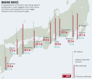
 In Miyagi, a M7.")
16 Subduction zone earthquakes in Japan 2010 view Hokkaido Kobe Tokyo Tohoku Ibaraki Tokachi Sanriku Miyagi Fukushima Kushiro Off Miyagi earthquake M7.5, 99% (30 years) In Miyagi, a M7.5 earthquake has occurred at intervals of about 40 years for hundreds of years

17 Subduction zone earthquakes in Japan Actual event was much larger than anticipated: M9 - which had been not experienced for hundreds of years. Tokyo Hokkaido Tohoku Ibaraki Tokachi Sanriku Kushiro Miyagi 2011 March 11 Off Tohoku Earthquake Fukushima Likely previous event 869 Jogan


")

18 Intense and long duration shaking in populated cities due to amplification of ground motions in soft sediments Visualized REAL wavefield using 1800 stations Shaking skyscrapers (NHK TV) 2 G 1 min Ground acceleration (cm/s/s) Miyagi Tokyo Fukushima

19 2011 Land Subsidence Crustal deformation after the earthquake Miyagi Horizontal Vertical 530 cm GEONET: Geological Survey of Japan 120 cm Due to crustal deformation by the earthquake NE Japan moved 5.3 m east, and subsided 1.2 m. Sea water does not return because of the land subsidence. 19

 tsunami in 30 min.")

20 Upheaval of sea bottom caused by the earthquake produced tsunami. The large (> 5m) tsunami off Tohoku (80 km offshore) warned of the attack of huge (>30m) tsunami in 30 min. Tsunami produced by sea bottom deformation Tsunami height [m] 5 m 浸水高 [m] 2 m t/ 10 min 20 min TM2 TM1 Ocean bottom tsunami record Tsunami simulation


 2011 Off")
21 2011 Event Mechanism Triggered sequence of ordinary earthquakes linked to a tsunami earthquake Continental Plate Trench 1896 Meiji Sanriku (M8.4) 2011 Off Tohoku M Enpo Boso-oki (M8)


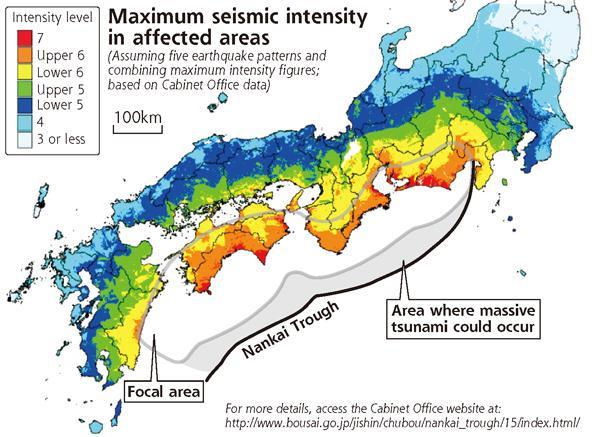
22 Re-evaluation of future Nankai-Trough earthquakes
 Thick")


23 Hoei Kowa (1) Thick tsunami deposit - x 2-5 thicker than that of Hoei - observed in Kyushu and Shikoku 3.11 Off Tohoku Tenmu AD B.C event Kaniga-ike Lake (2) Seismic slip? - friction-heat (seismic) slip 図 : JAMSTECによる near the trough? Kaniga Ike Lake Kochi Tokushima トラフ軸 Oita 海溝


24 - The 1707 Hoei earthquake (M8.7) which was the largest event in the past 300 years has been used for disaster prevention planning. - Recently an EXTREME model (M9.1) was presented based on recent knowledge of seismology/geology etc. Tokyo Earthquake Occurrence History (for past 300 years) 1707 Hoei 1854 Ansei 1944/ 1946 Showa
![Tsunami Height [m] EXTREME Nankai-trough](/docs-images/85/91758773/images/25-0.jpg "earthquake (1) Tsunami On coast Kochi 宝永地震 +")


25 Tsunami Height [m] EXTREME Nankai-trough earthquake (1) Tsunami On coast Kochi 宝永地震 + 慶長地震 EXTREME model Hoei Earthquake EXTREME earthquake times higher tsunami (ex. >20 m in Kochi ) -No effect on tsunami in internal sea and bay Kyushu Shikoku Kii Tokai Boso Osaka Kochi


26


27


 Input 2011 Off")
28 Expected long-period ground motions from the earthquake 2-3 times larger and 2 times longer duration than that of the off Tohoku earthquake Expecting Nankai Trough Earthquake Tokyo Shaking table test (Steel 30 floor) Input 2011 Off Tohoku Earthquake E-defense at Kobe

29 Nankai Scenarios 30

30 1707 Mt Fuji eruption A few months after the great 1707 earthquake. Mt Fuji had its most recent eruption Ash fell across the Tokyo region at levels that would cause major disruption today
31 Future developments 32 Improved seismic warning systems integrating rapid computation of earthquake effects Calculations of scenario earthquakes to provide full range of information for disaster assessment Better coupling of the full range of seismological and geodetic results to get an integrated picture on both short and long time-scales Enhanced awareness of potential impact for generations in western Japan who have not felt a great earthquake since the 1940 s

 Sustain")
 Temporary result")
32 Ground motion, crustal deformation, and tsunami from the 2011 Off Tohoku Earthquake Implemented on K Computer -24,576 node (196,608 cores) Sustain Performance: -0.5 PFLOPS (16-20 %) Temporary result Maeda and Furumura (2012)


33 Earthquake Early Warning from the Off Tohoku quake - Alarm started 5.4 s after the earthquake - Finally, at 110 s the estimated magnitude was set to M8.1


34 Prof. Takashi Furumura 古村孝志 & Earthquake Research Institute, University of Tokyo Earthquake Spokesman NHK
REPORT ON THE TOHOKU AREA PASIFIC OFFSHORE EARTHQUAKE
 REPORT ON THE TOHOKU AREA PASIFIC OFFSHORE EARTHQUAKE GENERAL PERSPECTIVE The Highest Magnitude Ever Recorded The 2011 off the Pacific Coast of Tohoku Earthquake (hereafter, the 2011 Tohoku- Pacific Earthquake
Seismic Activity and Crustal Deformation after the 2011 Off the Pacific Coast of Tohoku Earthquake
 J-RAPID Symposium March 6-7, 2013 Seismic Activity and Crustal Deformation after the 2011 Off the Pacific Coast of Tohoku Earthquake Y. Honkura Tokyo Institute of Technology Japan Science and Technology
Earthquake Source. Kazuki Koketsu. Special Session: Great East Japan (Tohoku) Earthquake. Earthquake Research Institute, University of Tokyo
 Earthquake. Earthquake Research Institute, University of Tokyo") 2012/9/24 17:20-17:35 WCEE SS24.4 Special Session: Great East Japan (Tohoku) Earthquake Earthquake Source Kazuki Koketsu Earthquake Research Institute, University of Tokyo 1 Names and features of the earthquake
2012/9/24 17:20-17:35 WCEE SS24.4 Special Session: Great East Japan (Tohoku) Earthquake Earthquake Source Kazuki Koketsu Earthquake Research Institute, University of Tokyo 1 Names and features of the earthquake
THE 2011 TOHOKU EARTHQUAKE IN JAPAN. VSU Lyuben Karavelov, Sofia, Bulgaria. Key words: Tohoku earthquake, strong ground motion, damage
 THE 2011 TOHOKU EARTHQUAKE IN JAPAN Radan Ivanov 1 VSU Lyuben Karavelov, Sofia, Bulgaria Abstract: This earthquake which occurred on March 11, 2011, had a magnitude of 9.0, which places it as the fourth
Takashi Furumura Tatsuhiko Saito ERI. Univ. Tokyo)
") CREST Workshop in 2007 An Integrated Simulation of Seismic Wave and Tsunami Propagation 古村孝志 齊藤竜彦 (東大地震研 Takashi Furumura Tatsuhiko Saito ERI. Univ. Tokyo) 2006 2007 Hokkaido -O Izu ough r T kai Nan ch
CREST Workshop in 2007 An Integrated Simulation of Seismic Wave and Tsunami Propagation 古村孝志 齊藤竜彦 (東大地震研 Takashi Furumura Tatsuhiko Saito ERI. Univ. Tokyo) 2006 2007 Hokkaido -O Izu ough r T kai Nan ch
Strong ground motions from the 2011 off-the Pacific-Coast-of-Tohoku, Japan (Mw=9.0) earthquake obtained from a dense nationwide seismic network
 earthquake obtained from a dense nationwide seismic network") Landslides (2011) 8:333 338 DOI 10.1007/s10346-011-0279-3 Received: 10 June 2011 Accepted: 5 July 2011 Published online: 23 July 2011 The Author(s) 2011. This article is published with open access at Springerlink.com
Landslides (2011) 8:333 338 DOI 10.1007/s10346-011-0279-3 Received: 10 June 2011 Accepted: 5 July 2011 Published online: 23 July 2011 The Author(s) 2011. This article is published with open access at Springerlink.com
Earthquakes and Tsunamis
 Earthquakes and Tsunamis Kenji Satake Earthquake Research Institute University of Tokyo 1 Part I 2011 Tohoku earthquake and tsunami 2 Fukushima Dai ichi NPP accident Earthquake ground motion Reactors automatically
Real Time Monitoring System for Megathrust Earthquakes and Tsunamis - Cabled Network System and Buoy System in Japan -
 Real Time Monitoring System for Megathrust Earthquakes and Tsunamis - Cabled Network System and Buoy System in Japan - 1 Subduction zones around the world Haiti Italy Turkey Tohoku Sichuan Taiwan Sumatra
JMA Tsunami Warning Services. Tomoaki OZAKI Senior Coordinator for Tsunami Forecast Modeling Japan Meteorological Agency
 JMA Tsunami Warning Services Tomoaki OZAKI Senior Coordinator for Tsunami Forecast Modeling Japan Meteorological Agency Organization Chart of the Government of Japan Cabinet Office Diet Ministry of Internal
Crustal deformation by the Southeast-off Kii Peninsula Earthquake
 Crustal deformation by the Southeast-off Kii Peninsula Earthquake 51 Crustal deformation by the Southeast-off Kii Peninsula Earthquake Tetsuro IMAKIIRE, Shinzaburo OZAWA, Hiroshi YARAI, Takuya NISHIMURA
Inversion Analysis of Historical Interplate Earthquakes Using Seismic Intensity Data
 Inversion Analysis of Historical Interplate Earthquakes Using Seismic Intensity Data Katsuhisa Kanda and Masayuki Takemura Kobori Research Complex, Kajima Corporation, Tokyo 107-8502, Japan Summary An
Earthquake Hazards. Tsunami
 Earthquake Hazards Tsunami Review: What is an earthquake? Earthquake is the vibration (shaking) and/or displacement of the ground produced by the sudden release of energy. The point inside the Earth where
Earthquake Hazards. Tsunami
 Earthquake Hazards Tsunami Review: What is an earthquake? Earthquake is the vibration (shaking) and/or displacement of the ground produced by the sudden release of energy. The point inside the Earth where
Earthquake Hazards. Tsunami
 Earthquake Hazards Tsunami Measuring Earthquakes Two measurements that describe the power or strength of an earthquake are: Intensity a measure of the degree of earthquake shaking at a given locale based
THEORETICAL EVALUATION OF EFFECTS OF SEA ON SEISMIC GROUND MOTION
 13 th World Conference on Earthquake Engineering Vancouver, B.C., Canada August 1-6, 2004 Paper No. 3229 THEORETICAL EVALUATION OF EFFECTS OF SEA ON SEISMIC GROUND MOTION Ken HATAYAMA 1 SUMMARY I evaluated
Advanced School on Direct and Inverse Problems of Seismology
 2167-17 Advanced School on Direct and Inverse Problems of Seismology 27 September - 8 October, 2010 Achievements of strong motion seismology and its future directions Kojiro Irikura Kyoto University Japan
Tohoku-oki event: Tectonic setting
 Tohoku-oki event: Tectonic setting This earthquake was the result of thrust faulting along or near the convergent plate boundary where the Pacific Plate subducts beneath Japan. This map also shows the
JMA Tsunami Warning Services. Takeshi KOIZUMI Senior Coordinator for International Earthquake and Tsunami Information Japan Meteorological Agency
 JMA Tsunami Warning Services Takeshi KOIZUMI Senior Coordinator for International Earthquake and Tsunami Information Japan Meteorological Agency Tectonic Setting of Japan (Headquarters for Earthquake Research
Genpatsu-Shinsai: Catastrophic Multiple Disaster of Earthquake and Quake-induced Nuclear Accident Anticipated in the Japanese Islands
 To the Abstract K. Ishibashi (2003) Genpatsu-Shinsai: Catastrophic Quake and Nuke Disaster Complex IUGG2003 Sappro JSP11 Geophysical Risk and Vulnerability: The Population-Hazard Interaction July 7, Mon.,14:30
Simulated Earthquake Ground Motion for Structural Design"
 14 th U.S.-Japan Workshop on the Improvement of Building Structural Design and Construction Practices Simulated Earthquake Ground Motion for Structural Design" Satoru Nagase Structural Engineering Section,
How GNSS CORS in Japan works for geodetic control and disaster mitigations
 ICG Working Group D Reference Frames, Timing and Applications How GNSS CORS in Japan works for geodetic control and disaster mitigations ICG11, Nov. 7-11, 2016, Sochi, Russia Hiromichi TSUJI Geodetic Observation
気象研究所技術報告第 77 号 2017 第 1 章巨大地震の規模等の把握 1.1 様々な早期規模推定手法 本項の論文は, 著者からの転載許可を受けて掲載している (Katsumata, A., S. Aoki, Y. Yoshida, H. Ueno and T. Yokota, 2012: Ra
 第 1 章巨大地震の規模等の把握 1.1 様々な早期規模推定手法 本項の論文は, 著者からの転載許可を受けて掲載している (Katsumata, A., S. Aoki, Y. Yoshida, H. Ueno and T. Yokota, 2012: Rapid source parameter estimation of great earthquakes for tsunami warning,
GROUND MOTION SPECTRAL INTENSITY PREDICTION WITH STOCHASTIC GREEN S FUNCTION METHOD FOR HYPOTHETICAL GREAT EARTHQUAKES ALONG THE NANKAI TROUGH, JAPAN
 GROUND MOTION SPECTRAL INTENSITY PREDICTION WITH STOCHASTIC GREEN S FUNCTION METHOD FOR HYPOTHETICAL GREAT EARTHQUAKES ALONG THE NANKAI TROUGH, JAPAN Masayuki YOSHIMI 1, Yasuto KUWAHARA 2, Masayuki YAMADA
LETTER Earth Planets Space, 56, , 2004
 LETTER Earth Planets Space, 56, 353 357, 2004 Deep seismic activities preceding the three large shallow earthquakes off south-east Hokkaido, Japan the 2003 Tokachi-oki earthquake, the 1993 Kushiro-oki
SEISMIC HAZARD ASSESSMENT FOR JAPAN AFTER THE 2011 TOHOKU-OKI MEGA-THRUST EARTHQUAKE (Mw9.0)
") Proceedings of the International Symposium on Engineering Lessons Learned from the 2011 Great East Japan Earthquake, March 1-4, 2012, Tokyo, Japan SEISMIC HAZARD ASSESSMENT FOR JAPAN AFTER THE 2011 TOHOKU-OKI
Proceedings of the International Symposium on Engineering Lessons Learned from the 2011 Great East Japan Earthquake, March 1-4, 2012, Tokyo, Japan SEISMIC HAZARD ASSESSMENT FOR JAPAN AFTER THE 2011 TOHOKU-OKI
Source modeling of hypothetical Tokai-Tonankai-Nankai, Japan, earthquake and strong ground motion simulation using the empirical Green s functions
 Source modeling of hypothetical Tokai-Tonankai-Nankai, Japan, earthquake and strong ground motion simulation using the empirical Green s functions Y. Ishii & K. Dan Ohsaki Research Institute, Inc., Tokyo
Recent Progress of Seismic Observation Networks in Japan
 Journal of Physics: Conference Series Recent Progress of Seismic Observation Networks in Japan To cite this article: Y Okada 2013 J. Phys.: Conf. Ser. 433 012039 Related content - Physical applications
Dense Ocean floor Network System for Earthquakes and Tsunamis DONET
 Dense Ocean floor Network System for Earthquakes and Tsunamis DONET Yoshiyuki Kaneda Japan Agency for Marine-Earth Science and Technology (JAMSTEC) ION 1 Earthquakes in the Nankai Trough Tokai Nankai Hyuga
KNOWLEDGE NOTE 5-1. Risk Assessment and Hazard Mapping. CLUSTER 5: Hazard and Risk Information and Decision Making. Public Disclosure Authorized
 Public Disclosure Authorized Public Disclosure Authorized Public Disclosure Authorized Public Disclosure Authorized KNOWLEDGE NOTE 5-1 CLUSTER 5: Hazard and Risk Information and Decision Making Risk Assessment
Coseismic slip model
 Figure 3 - Preliminary highly smoothed model of coseismic slip for the 11 March UCL Institute for Risk & Disaster Reduction Magnitude 9.0 (JMA scale) earthquake Occurred at 02:46:23 pm local time near
Source region of the earthquake
 Disasters of port facilities due to 2011 Great East Japan Earthquake Yoshiaki Kikuchi Port & Airport Research Institute Contents Outline of the earthquake Measured Tsunami height Breakwater disasters by
Forecasting Future Earthquakes from Tsunami Deposits and Simulation
 Forecasting Future Earthquakes from Tsunami Deposits and Simulation Kenji Satake Earthquake Research Institute The University of Tokyo satake@eri.u-tokyo.ac.jp Contents 1. Earthquake Recurrence and Forecast
Real time Monitoring System for Earthquakes and Tsunamis (DONET)
") Real time Monitoring System for Earthquakes and Tsunamis (DONET) NankaiTrough Yoshiyuki Kaneda Japan Agency for Marine-Earth Science and Technology (JAMSTEC) POGO@Seoul Presentation 1 Earthquakes in the
Real time Monitoring System for Earthquakes and Tsunamis (DONET) NankaiTrough Yoshiyuki Kaneda Japan Agency for Marine-Earth Science and Technology (JAMSTEC) POGO@Seoul Presentation 1 Earthquakes in the
AVERAGE AND VARIATION OF FOCAL MECHANISM AROUND TOHOKU SUBDUCTION ZONE
 13 th World Conference on Earthquake Engineering Vancouver, B.C., Canada August 1-6, 24 Paper No. 414 AVERAGE AND VARIATION OF FOCAL MECHANISM AROUND TOHOKU SUBDUCTION ZONE Shunroku YAMAMOTO 1 Naohito
Investigation of mechanisms causing ground motion and tsunami due to the 2011 Tohoku Earthquake at Nuclear Power Plant sites
 Investigation of mechanisms causing ground motion and tsunami due to the 211 Tohoku Earthquake at Nuclear Power Plant sites Hideharu Sugino, Yoko Iwabuchi, Katsumi Ebisawa Japan Nuclear Energy Safety Organization
Three Dimensional Simulations of Tsunami Generation and Propagation
 Chapter 1 Earth Science Three Dimensional Simulations of Tsunami Generation and Propagation Project Representative Takashi Furumura Authors Tatsuhiko Saito Takashi Furumura Earthquake Research Institute,
- Information before strong ground motion -
 -Earthquake Early Warning - Information before strong ground motion - Mitsuyuki HOSHIBA Japan Meteorological Agency January 12, 2007 1 Distribution of Earthquakes Causing Tsunami (1896~2004) in Japan Distribution
Tsunami waves swept away houses and cars in northern Japan and pushed ships aground.
 Japan was struck by a magnitude 8.9 earthquake off its northeastern coast Friday. This is one of the largest earthquakes that Japan has ever experienced. In downtown Tokyo, large buildings shook violently
Deterministic and Non-deterministic Behavior of Earthquakes and Hazard Mitigation Strategy
 Deterministic and Non-deterministic Behavior of Earthquakes and Hazard Mitigation Strategy Hiroo Kanamori Seismological Laboratory, California Institute of Technology Earthquake Process Deterministic Non-deterministic
Three Fs of earthquakes: forces, faults, and friction. Slow accumulation and rapid release of elastic energy.
 Earthquake Machine Stick-slip: Elastic Rebound Theory Jerky motions on faults produce EQs Three Fs of earthquakes: forces, faults, and friction. Slow accumulation and rapid release of elastic energy. Three
New Seismic Activity Model of Large Earthquakes along Nankai Trough for Probabilistic Seismic Hazard Maps
 New Seismic Activity Model of Large Earthquakes along Nankai Trough for Probabilistic Seismic Hazard Maps Toshihiko Okumura (Shimizu Corp.) Hiroyuki Fujiwara (NIED) Plate Tectonics around Japan Pacific
The 2011 Tohoku Earthquake and Tsunami Sequence. Mitchell May, EPSC 330
 The 2011 Tohoku Earthquake and Tsunami Sequence Mitchell May, 260556044 EPSC 330 The 2011 earthquake sequence east of Tohoku is classified as a megathrust earthquake off the east coast of Japan. The earthquake
What is an Earthquake?
 Earthquakes What is an Earthquake? Earthquake - sometimes violent shaking of ground caused by movement of Earth s tectonic plates; creates seismic waves Often followed by smaller earthquakes (aftershocks);
Sendai Earthquake NE Japan March 11, Some explanatory slides Bob Stern, Dave Scholl, others updated March
 Sendai Earthquake NE Japan March 11, 2011 Some explanatory slides Bob Stern, Dave Scholl, others updated March 14 2011 Earth has 11 large plates and many more smaller ones. Plates are 100-200 km thick
Japan Agency for Marine-Earth Science and Technology (JAMSTEC), 2-15 Natsushima-cho, Yokosuka JAPAN
, 2-15 Natsushima-cho, Yokosuka JAPAN") Dense Ocean floor Network System for Mega Thrust Earthquakes & Tsunamis(DONET) -Towards Understanding Mega Thrust Earthquakes, the Geohazard & Disaster Mitigation- Yoshiyuki KANEDA, Katsuyoshi KAWAGUCHI,
Dense Ocean floor Network System for Mega Thrust Earthquakes & Tsunamis(DONET) -Towards Understanding Mega Thrust Earthquakes, the Geohazard & Disaster Mitigation- Yoshiyuki KANEDA, Katsuyoshi KAWAGUCHI,
Depth-dependent slip regime on the plate interface revealed from slow earthquake activities in the Nankai subduction zone
 2010/10/11-14 Earthscope Workshop Depth-dependent slip regime on the plate interface revealed from slow earthquake activities in the Nankai subduction zone Kazushige Obara, ERI, Univ. Tokyo Recurrence
UGRC 144 Science and Technology in Our Lives/Geohazards
 UGRC 144 Science and Technology in Our Lives/Geohazards Session 3 Understanding Earthquakes and Earthquake Hazards Lecturer: Dr. Patrick Asamoah Sakyi Department of Earth Science, UG Contact Information:
Earthquakes and Earthquake Hazards Earth - Chapter 11 Stan Hatfield Southwestern Illinois College
 Earthquakes and Earthquake Hazards Earth - Chapter 11 Stan Hatfield Southwestern Illinois College What Is an Earthquake? An earthquake is the vibration of Earth, produced by the rapid release of energy.
Earthquakes. Building Earth s Surface, Part 2. Science 330 Summer What is an earthquake?
 Earthquakes Building Earth s Surface, Part 2 Science 330 Summer 2005 What is an earthquake? An earthquake is the vibration of Earth produced by the rapid release of energy Energy released radiates in all
Disclaimer. This report was compiled by an ADRC visiting researcher (VR) from ADRC member countries.
 from ADRC member countries.") Disclaimer This report was compiled by an ADRC visiting researcher (VR) from ADRC member countries. The views expressed in the report do not necessarily reflect the views of the ADRC. The boundaries and
Disclaimer This report was compiled by an ADRC visiting researcher (VR) from ADRC member countries. The views expressed in the report do not necessarily reflect the views of the ADRC. The boundaries and
Amplification of Tsunami Heights by Delayed Rupture of Great Earthquakes along the Nankai Trough
 Amplification of Tsunami Heights by Delayed Rupture of Great Earthquakes along the Nankai Trough Kentaro Imai 1,2, Kenji Satake 2 and Takashi Furumura 1,2 1 Center for Integrated Disaster Information Research,
Fault Length and Direction of Rupture Propagation for the 1993 Kushiro-Oki Earthquake as Derived from Strong Motion Duration
 Letter J. Phys. Earth, 41, 319-325, 1993 Fault Length and Direction of Rupture Propagation for the 1993 Kushiro-Oki Earthquake as Derived from Strong Motion Duration Yasuo Izutani Faculty of Engineering,
Earthquakes Chapter 19
 Earthquakes Chapter 19 Does not contain complete lecture notes. What is an earthquake An earthquake is the vibration of Earth produced by the rapid release of energy Energy released radiates in all directions
MECHANISM OF THE 2011 TOHOKU-OKI EARTHQUAKE: INSIGHT FROM SEISMIC TOMOGRAPHY
 Proceedings of the International Symposium on Engineering Lessons Learned from the 2011 Great East Japan Earthquake, March 1-4, 2012, Tokyo, Japan MECHANISM OF THE 2011 TOHOKU-OKI EARTHQUAKE: INSIGHT FROM
中村洋光 Hiromitsu Nakamura 防災科学技術研究所 National Research Institute for Earth Science and Disaster Prevention, Japan (NIED) Outline
 Outline") Earthquake Early Warning in Japan 中村洋光 Hiromitsu Nakamura 防災科学技術研究所 National Research Institute for Earth Science and Disaster Prevention, Japan (NIED) Outline Overview of the earthquake early warning
Earthquake Early Warning in Japan 中村洋光 Hiromitsu Nakamura 防災科学技術研究所 National Research Institute for Earth Science and Disaster Prevention, Japan (NIED) Outline Overview of the earthquake early warning
Coseismic slip distribution of the 2011 off the Pacific Coast of Tohoku Earthquake (M9.0) refined by means of seafloor geodetic data
 refined by means of seafloor geodetic data") JOURNAL OF GEOPHYSICAL RESEARCH, VOL. 117,, doi:10.1029/2012jb009186, 2012 Coseismic slip distribution of the 2011 off the Pacific Coast of Tohoku Earthquake (M9.0) refined by means of seafloor geodetic
JOURNAL OF GEOPHYSICAL RESEARCH, VOL. 117,, doi:10.1029/2012jb009186, 2012 Coseismic slip distribution of the 2011 off the Pacific Coast of Tohoku Earthquake (M9.0) refined by means of seafloor geodetic
ACTIVITIES OF THE HEADQUARTERS FOR EARTHQUAKE RESEARCH PROMOTION
 Journal of Japan Association for Earthquake Engineering, Vol.4, No.3 (Special Issue), 2004 ACTIVITIES OF THE HEADQUARTERS FOR EARTHQUAKE RESEARCH PROMOTION Sadanori HIGASHI 1 1 Member of JAEE, Earthquake
Effects of Surface Geology on Seismic Motion
 4 th IASPEI / IAEE International Symposium: Effects of Surface Geology on Seismic Motion August 23 26, 2011 University of California Santa Barbara BROADBAND STRONG GROUND MOTION PREDICTION FOR HYPOTHETICAL
Historical Maximum Seismic Intensity Maps in Japan from 1586 to 2004: Construction of Database and Application. Masatoshi MIYAZAWA* and Jim MORI
 Annuals of Disas. Prev. Res. Inst., Kyoto Univ., No. 4C, 25 Historical Maximum Seismic Intensity Maps in Japan from 6 to 24: Construction of Database and Application Masatoshi MIYAZAWA* and Jim MORI *
Estimation of Damage Ratios of Wooden Houses and Water Distribution Pipelines in an Earthquake Scenario for the Tokyo Metropolitan Region
 The 2011 World Congress on Advances in Structural Engineering and Mechanics (ASEM'11 + ) Seoul, Korea, 18-22 September, 2011 Estimation of Damage Ratios of Wooden Houses and Water Distribution Pipelines
Damage Estimation of the Road Bridge Structure Using the Seismic Hazard map for BCM in Hokkaido, Japan
 Damage Estimation of the Road Bridge Structure Using the Seismic Hazard map for BCM in Hokkaido, Japan T. Sato & H. Nishi Civil Engineerring Research Institute for Cold Region, PWRI,Japan T. Ikeda & Y.
FORCES ON EARTH. An investigation into how Newton s Laws of Motion are applied to the tectonic activity on Earth.
 FORCES ON EARTH An investigation into how Newton s Laws of Motion are applied to the tectonic activity on Earth. GEOLOGY Geologists scientists who study the forces that make and shape the Earth Geologists
Checking of Seismic and Tsunami Hazard for Coastal NPP of Chinese Continent
 Checking of Seismic and Tsunami Hazard for Coastal NPP of Chinese Continent Chang Xiangdong (Nuclear and Radiation Safety Center, MEP, China) 2012.Sep 1. Introduction After Japanese Fukushima nuclear accident
Source Characteristics of Large Outer Rise Earthquakes in the Pacific Plate
 Source Characteristics of Large Outer Rise Earthquakes in the Pacific Plate T. Sasatani, N. Takai, M. Shigefuji, and Y. Miyahara Hokkaido University, Sapporo, Japan W. Kawabata Electric Power Development
Lessons from the 2004 Sumatra earthquake and the Asian tsunami
 Lessons from the 2004 Sumatra earthquake and the Asian tsunami Kenji Satake National Institute of Advanced Industrial Science and Technology Outline 1. The largest earthquake in the last 40 years 2. Tsunami
Section Forces Within Earth. 8 th Grade Earth & Space Science - Class Notes
 Section 19.1 - Forces Within Earth 8 th Grade Earth & Space Science - Class Notes Stress and Strain Stress - is the total force acting on crustal rocks per unit of area (cause) Strain deformation of materials
Effect of an outer-rise earthquake on seismic cycle of large interplate earthquakes estimated from an instability model based on friction mechanics
 Effect of an outer-rise earthquake on seismic cycle of large interplate earthquakes estimated from an instability model based on friction mechanics Naoyuki Kato (1) and Tomowo Hirasawa (2) (1) Geological
Features of Tsunami height according to type of coastal landforms 2011 Tohoku oki tsunami case
 Features of Tsunami height according to type of coastal landforms 2011 Tohoku oki tsunami case (70 Nobuhisa Matta (Disaster Mitigation Research Center Nagoya Univ.) July 3 rd, 2013, at Taipei Outline +
Blank line 10 pt Keywords: Response Characteristics, Skyscraper, Tohoku-Oki earthquake, Natural operiod
 A Study on the Response Characteristics of a High-Rise Building Built on the Reclaimed Land along the Osaka Bay Yuta Akizuki Graduate School of Engineering, Kyoto University, Kyoto, Japan Blank Line 9
JAMSTEC Marine Geophysical Projects for Researches on Subduction Cycles and Deformation
 JAMSTEC Marine Geophysical Projects for Researches on Subduction Cycles and Deformation Shuichi Kodaira Research Center for Earthquake and Tsunami JAMSTEC JAMSTEC Marine Geophysical Projects Motivation:
Section 19.1: Forces Within Earth Section 19.2: Seismic Waves and Earth s Interior Section 19.3: Measuring and Locating.
 CH Earthquakes Section 19.1: Forces Within Earth Section 19.2: Seismic Waves and Earth s Interior Section 19.3: Measuring and Locating Earthquakes Section 19.4: Earthquakes and Society Section 19.1 Forces
Lecture Outline Wednesday-Monday April 18 23, 2018
 Lecture Outline Wednesday-Monday April 18 23, 2018 Questions? Lecture Final Exam Lecture Section 1 Friday May 4, 8:00-10:00am Lecture Section 2 Friday May 4, 3:10-5:10 pm Final Exam is 70% new material
apanese Nationwide Earthquake and Tsunami Observation Network Operated by NIED
 APEC Workshop on Application of Big Data and Open Data@Taipei Garden Hotel (2015/10/29-30) apanese Nationwide Earthquake and Tsunami Observation Network Operated by NIED Shin Aoi National Research Institute
PREDICTION OF AVERAGE SHEAR-WAVE VELOCITY FOR GROUND SHAKING MAPPING USING THE DIGITAL NATIONAL LAND INFORMATION OF JAPAN
 th World Conference on Earthquake Engineering Vancouver, B.C., Canada August -6, 00 Paper No. 07 PREDICTION OF AVERAGE SHEAR-WAVE VELOCITY FOR GROUND SHAKING MAPPING USING THE DIGITAL NATIONAL LAND INFORMATION
Annual Report for Research Work in the fiscal year 2005
 JST Basic Research Programs C R E S T (Core Research for Evolutional Science and Technology) Annual Report for Research Work in the fiscal year 2005 Research Area : High Performance Computing for Multi-scale
Development of a Predictive Simulation System for Crustal Activities in and around Japan - II
 Development of a Predictive Simulation System for Crustal Activities in and around Japan - II Project Representative Mitsuhiro Matsu'ura Graduate School of Science, The University of Tokyo Authors Mitsuhiro
Active Faults along Japan Trench and Source Faults of Large Earthquakes
 Proceedings of the International Symposium on Engineering Lessons Learned from the 2011 Great East Japan Earthquake, March 1-4, 2012, Tokyo, Japan Active Faults along Japan Trench and Source Faults of
Earthquakes. Earthquake Magnitudes 10/1/2013. Environmental Geology Chapter 8 Earthquakes and Related Phenomena
 Environmental Geology Chapter 8 Earthquakes and Related Phenomena Fall 2013 Northridge 1994 Kobe 1995 Mexico City 1985 China 2008 Earthquakes Earthquake Magnitudes Earthquake Magnitudes Richter Magnitude
STRONG MOTION RECORDS FROM THE 2011 OFF THE PACIFIC COAST OF TOHOKU EARTHQUAKE
 Proceedings of the International Symposium on Engineering Lessons Learned from the 211 Great East Japan Earthquake, March 1-4, 212, Tokyo, Japan STRONG MOTION RECORDS FROM THE 211 OFF THE PACIFIC COAST
Running Head: JAPANESE TSUNAMI 1. Geological Perspective of the Japanese Tsunami
 Running Head: JAPANESE TSUNAMI 1 Geological Perspective of the Japanese Tsunami JAPANESE TSUNAMI 2 JAPANESE TSUNAMI 3 Abstract Humanity is characterized with flaws, so is planet earth. Earthquakes shake
Outline of the 2011 off the Pacific coast of Tohoku Earthquake (M w 9.0) Earthquake Early Warning and observed seismic intensity
 Earthquake Early Warning and observed seismic intensity") LETTER Earth Planets Space, 63, 547 551, 2011 Outline of the 2011 off the Pacific coast of Tohoku Earthquake (M w 9.0) Earthquake Early Warning and observed seismic intensity Mitsuyuki Hoshiba 1, Kazuhiro
LETTER Earth Planets Space, 63, 547 551, 2011 Outline of the 2011 off the Pacific coast of Tohoku Earthquake (M w 9.0) Earthquake Early Warning and observed seismic intensity Mitsuyuki Hoshiba 1, Kazuhiro
Peter Sammonds Professor of Geophysics
 Peter Sammonds Professor of Geophysics Director, UCL Institute for Risk & Disaster Reduction NERC Strategic Advisor The precautionary principle: Natural hazards and critical infrastructure Acknowledge
REGIONAL CHARACTERISTICS OF STRESS FIELD AND ITS DYNAMICS IN AND AROUND THE NANKAI TROUGH, JAPAN
 46 4 2003 7 CHINESE JOURNAL OF GEOPHYSICS Vol. 46, No. 4 July, 2003 1 1 2 3 1, 100037 2, 920-1192 3, 237-0061,,, : -. (10 22 ), (60 85km) ; (40 ), (160km)..,. GPS,, -,,.,,,.. 0001-5733(2003) 04-0488 -
Indian Ocean Tsunami Warning System: Example from the 12 th September 2007 Tsunami
 Indian Ocean Tsunami Warning System: Example from the 12 th September 2007 Tsunami Charitha Pattiaratchi 1 Professor of Coastal Oceanography, The University of Western Australia Email: chari.pattiaratchi@uwa.edu.au
Tectonic Processes and Hazards Enquiry Question 1: Why are some locations more at risk from tectonic hazards?
 Tectonic Processes and Hazards Enquiry Question 1: Why are some locations more at risk from tectonic hazards? Key words Basalt Andesite Rhyolite Benioff Zone Subduction zone Crustal fracturing Definition
Earthquakes Earth, 9th edition, Chapter 11 Key Concepts What is an earthquake? Earthquake focus and epicenter What is an earthquake?
 1 2 3 4 5 6 7 8 9 10 Earthquakes Earth, 9 th edition, Chapter 11 Key Concepts Earthquake basics. "" and locating earthquakes.. Destruction resulting from earthquakes. Predicting earthquakes. Earthquakes
Finding an Earthquake Epicenter Pearson Education, Inc.
 Finding an Earthquake Epicenter Measuring the Size of Earthquakes Two measurements that describe the size of an earthquake are: 1. Intensity a measure of the degree of earthquake shaking at a given locale
S. Toda, S. Okada, D. Ishimura, and Y. Niwa International Research Institute of Disaster Science, Tohoku University, Japan
 The first surface-rupturing earthquake in 20 years on a HERP major active fault: Mw=6.2 2014 Nagano, Japan, event along the Itoigawa-Shizuoka Tectonic Line is not characteristic S. Toda, S. Okada, D. Ishimura,
Frequency-dependent Strong Motion Duration Using Total Threshold Intervals of Velocity Response Envelope
 Proceedings of the Tenth Pacific Conference on Earthquake Engineering Building an Earthquake-Resilient Pacific 6-8 November 015, Sydney, Australia Frequency-dependent Strong Motion Duration Using Total
The potential tsunami threats from the South China Sea and hazard mitigation
 The potential tsunami threats from the South China Sea and hazard mitigation Dr. Tso-Ren Wu ( 吳祚任 ) Graduate Institute of Hydrological and Oceanic Sciences National Central University 國立中央大學水文與海洋科學研究所
Special feature: Are its lessons being adequately applied? Follow-up on the ten-year anniversary of the Hanshin-Awaji Earthquake
 Special feature: Are its lessons being adequately applied? Follow-up on the ten-year anniversary of the Hanshin-Awaji Earthquake - Are we prepared for future massive earthquakes? - Hisakazu SAKAI Member
Long-period Ground Motion Characteristics of the Osaka Sedimentary Basin during the 2011 Great Tohoku Earthquake
 Long-period Ground Motion Characteristics of the Osaka Sedimentary Basin during the 2011 Great Tohoku Earthquake K. Sato, K. Asano & T. Iwata Disaster Prevention Research Institute, Kyoto University, Japan
Unit 7: Dynamic Planet: Earthquakes & Volcanoes
 Unit 7: Dynamic Planet: Earthquakes & Volcanoes Lecture 3 Objectives: E3.4C - Describe the effects of earthquakes and volcanic eruptions on humans. E3.4f - Explain why fences are offset after an earthquake
RECIPE FOR PREDICTING STRONG GROUND MOTIONS FROM FUTURE LARGE INTRASLAB EARTHQUAKES
 RECIPE FOR PREDICTING STRONG GROUND MOTIONS FROM FUTURE LARGE INTRASLAB EARTHQUAKES T. Sasatani 1, S. Noguchi, T. Maeda 3, and N. Morikawa 4 1 Professor, Graduate School of Engineering, Hokkaido University,
SOURCE MODELING OF SUBDUCTION-ZONE EARTHQUAKES AND LONG-PERIOD GROUND MOTION VALIDATION IN THE TOKYO METROPOLITAN AREA
 SOURCE MODELING OF SUBDUCTION-ZONE EARTHQUAKES AND LONG-PERIOD GROUND MOTION VALIDATION IN THE TOKYO METROPOLITAN AREA ABSTRACT : Hiroe Miyake 1, Kazuki Koketsu 2, and Takashi Furumura 3,2 1 Assistant
NUMERICAL SIMULATION OF TSUNAMI PROPAGATION AND INUNDATION ALONG THE RAKHINE COAST AREAS IN MYANMAR
 NUMERICAL SIMULATION OF TSUNAMI PROPAGATION AND INUNDATION ALONG THE RAKHINE COAST AREAS IN MYANMAR Su Hninn Htwe Supervisor: Bunichiro SHIBAZAKI MEE12619 Yushiro FUJII ABSTRACT This study aimed to assess
Numerical Simulation of Seismic Wave Propagation and Strong Motions in 3D Heterogeneous Structure
 Numerical Simulation of Seismic Wave Propagation and Strong Motions in 3D Heterogeneous Structure Project Representative Takashi Furumura Author Takashi Furumura Center for Integrated Disaster Information
The Current Activities of the Headquarters for Earthquake Research Promotion Concerning Tonankai/Nankai Earthquakes
 The Current Activities of the Headquarters for Earthquake Research Promotion Concerning Tonankai/Nankai Earthquakes ISOGAI Keisuke Director of Earthquake Research Division, Research and Development Bureau,
Hazards in the Seattle Area. Disaster Questions. Where Were You? Where Were You? Volcanoes St. Helens Adams, Rainier, Glacier, Baker
 Hazards in the Seattle Area Volcanoes St. Helens Adams, Rainier, Glacier, Baker Earthquakes Outer coast Puget Sound (Seattle Fault & others) Tsunami Outer coast Puget Sound (Seattle Fault & others) Disaster
FORCES ON EARTH UNIT 3.2. An investigation into how Newton s Laws of Motion are applied to the tectonic activity on Earth.
 FORCES ON EARTH UNIT 3.2 An investigation into how Newton s Laws of Motion are applied to the tectonic activity on Earth. USE THESE NOTES: OUR HOME PLANET EARTH: What do you know about our planet? SO.HOW