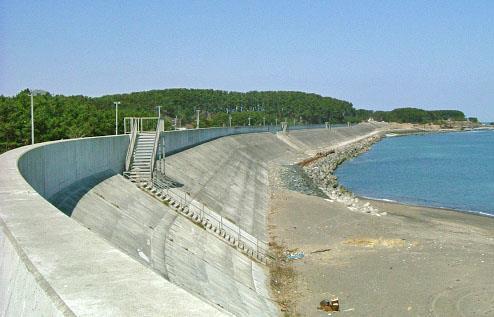
Prevention Tsunami wall 10m high (breached by the tsunami due to land level falling by 3m)
|
|
|
- Christopher Hicks
- 5 years ago
- Views:
Transcription
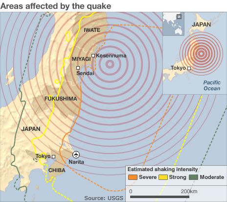
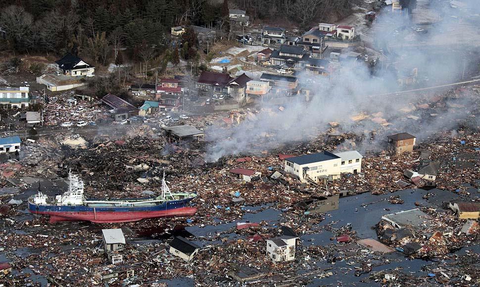
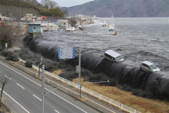
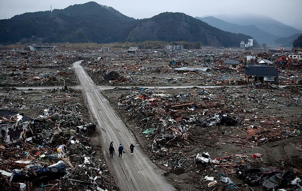
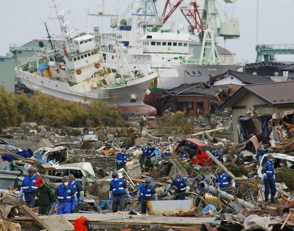
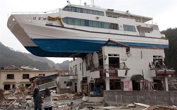
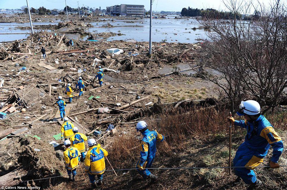
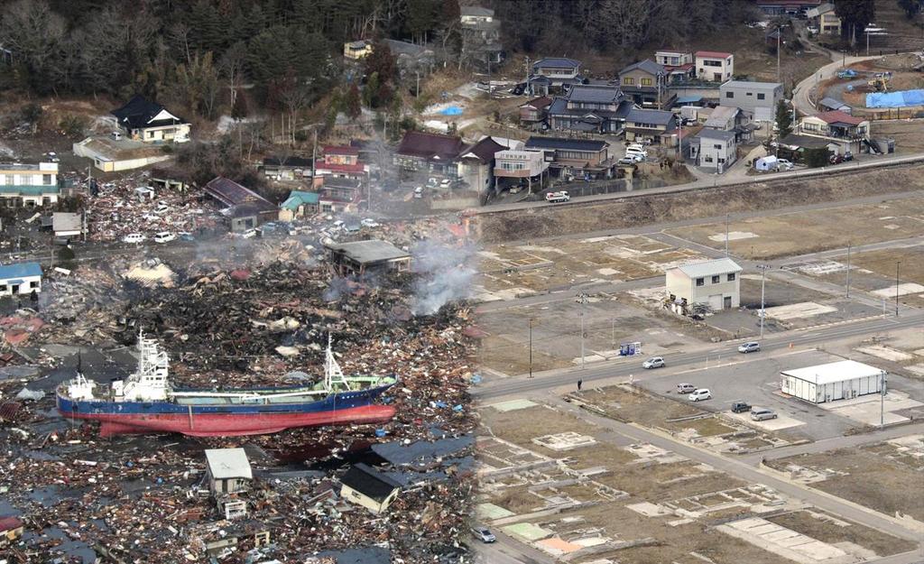
1 Plate margin Plates Causes Sendai, Japan Convergent plate margin Pacific and Eurasian Plates Convergent plate margin Sima (Pacific plate) moves towards the sial (Eurasian plate) Sima (Pacific plate) is subducted as it is more dense Pressure builds due to friction between the two plates Eventually pressure is released in a sudden jolt - 11/03/ Richter scale 2:46pm, Depth of focus 32km, Very long lasted 5 minutes, 130km from Sendai, 200 years of pressure released. Sial flicks upwards causing a tsunami with 10 metre high waves. Effects Local residents 10,000 deaths, 20,000 missing, 2,400 injured, 4.4m households without electricity, 1.5m without water, 11 hospitals destroyed, Soil liquefaction near Tokyo damaged over 1000 buildings Tsunami travelled 10km inland -10m high waves. Fukushima Nuclear power plant reactor overheated resulting in a level 7 radioactive leak contaminating a 120km radius Infrastructure - The tsunami blocked roads with debris and washed away bridges leaving the 900 residents of Miyagi island isolated. Land movement -Coast sunk by 1m, moved 4m into the Pacific Ocean Responses of people and organisations Prevention Tsunami wall 10m high (breached by the tsunami due to land level falling by 3m) Prediction Japanese Meteorological Agency predict EQs Warning systems send automatic messages to the media after P waves to warn of S waves Community preparedness EQ drills in large buildings every month 1919 Buildings Regulations Act requires buildings to be life-safe 1982 review of building regulations required new buildings to have shock absorbers Response to hazard US military 2,100 tonnes food 59 expert search and rescue teams US charities raised $49m over 6 days Japanese government predict that rebuilding will take up to 5 years.
2 Sendai Tsunami, Japan
3 4444 Background and causes people prevention Japan Tsunami effects environment responses
4

5 Pacific Plate Eurasian Plate
6
7
8
9 clip
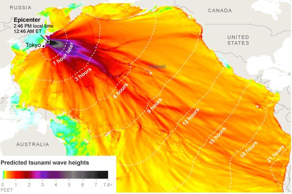
10 Sendai tsunami, 2011 The Pacific plate is under the Eurasian plate. Gradually built up for 200 years. When the earthquake occurred on the 11 th March 2011 at 2:46pm, the focus was very, 32km below the earth s surface, resulting in a magnitude 9 earthquake. The earthquake caused the plate to flick upwards displacing the Ocean causing a tsunami to spread outwards in all. It took just a few to reach the city of Sendai. As it approached the coastline the wave shortened and the wave height due to friction from the shallow sea bed nearer the coastline. When it got to Sendai the was 10m tall. Pressure deep Eurasian subducted tsunami directions Pacific length increased minutes
11
12
13
14
15
16
17
18
19
20
21
22 4444 Background and causes people prevention Japan Tsunami effects environment responses
23 Point Evidence (sp) Explanation 2 connectives So As a result This means that Because Also Death Nuclear Power Station overheated 10,000 people were killed by the tsunami Fukushima Nuclear power plant reactor overheated resulting in a level 7 radioactive leak contaminating a 120km radius. This means that whole communities may have been killed. As a result recovery from the tsunami will be severely affected due to the lack of skilled workers e.g. architects, builders and council planners. This means that local residents had to be evacuated from the surrounding areas. Also Blocked roads and washed away bridges The 900 residents of Miyagi island were left isolated. Land sunk Coast sunk by 1m, moved 4m into the Pacific Ocean
24 Point Evidence (sp) Explanation 2 connectives So As a result This means that Because Also Food provided for victims of the earthquake Trapped people searched for on the wreckage US military 2,100 tonnes food 59 expert search and rescue teams Due to the tsunami local food supplies in supermarkets were destroyed and transporting food to the areas affected was difficult. The aid means that communities affected by the earthquake are provided with food in evacuation centres. This means that people have a better chance of being rescued or dead bodies being found and identified. As a result Money raised to help victims US charities raised $49m over 6 days Government develop rebuilding plans Japanese government predict that rebuilding will take up to 5 years.
25 Plate margin Plates Causes Sendai, Japan Convergent plate margin Pacific and Eurasian Plates Convergent plate margin Sima (Pacific plate) moves towards the sial (Eurasian plate) Sima (Pacific plate) is subducted as it is more dense Pressure builds due to friction between the two plates Eventually pressure is released in a sudden jolt - 11/03/ Richter scale 2:46pm, Depth of focus 32km, Very long lasted 5 minutes, 130km from Sendai, 200 years of pressure released. Sial flicks upwards causing a tsunami with 10 metre high waves. Effects Local residents 10,000 deaths, 20,000 missing, 2,400 injured, 4.4m households without electricity, 1.5m without water, 11 hospitals destroyed, Soil liquefaction near Tokyo damaged over 1000 buildings Tsunami travelled 10km inland -10m high waves. Fukushima Nuclear power plant reactor overheated resulting in a level 7 radioactive leak contaminating a 120km radius Infrastructure - The tsunami blocked roads with debris and washed away bridges leaving the 900 residents of Miyagi island isolated. Land movement -Coast sunk by 1m, moved 4m into the Pacific Ocean Responses of people and organisations Prevention Tsunami wall 10m high (breached by the tsunami due to land level falling by 3m) Prediction Japanese Meteorological Agency predict EQs Warning systems send automatic messages to the media after P waves to warn of S waves Community preparedness EQ drills in large buildings every month 1919 Buildings Regulations Act requires buildings to be life-safe 1982 review of building regulations required new buildings to have shock absorbers Response to hazard US military 2,100 tonnes food 59 expert search and rescue teams US charities raised $49m over 6 days Japanese government predict that rebuilding will take up to 5 years.
26 Sendai Quiz 1. When did the earthquake occur? 11 th March :46pm 2. Which plate was subducted under the Eurasian plate? 3. How deep was the focus? 32km 4. How high was the tsunami? 10m 5. How many people died? 10, What was the name of the nuclear power plant that had a radiation leak? Fukushima 7. How many people were stranded on Miyagi island? How much did the coast sink by? 1m 9. How many tonnes of food were donated by the US? 2, How many rescue teams were sent to search for people? 11.How many years will it take to rebuild? 5 years 12.How long had the plates been stuck? 200 Pacific 59
Earthquake hazards. Aims 1. To know how hazards are classified 2. To be able to explain how the hazards occur 3. To be able to rank order hazards
 Earthquake hazards Aims 1. To know how hazards are classified 2. To be able to explain how the hazards occur 3. To be able to rank order hazards Types of hazard Primary A direct result of the earthquake
Tohoku Earthquake and Tsunami Japan March 11, 2011 Information updated 4/19/2011
 Tohoku Earthquake and Tsunami Japan March 11, 2011 Information updated 4/19/2011 On March 11, 2011 a massive earthquake occurred on the ocean floor south of the northeastern Tohoku region of the Japanese
The map below shows the locations of earthquakes and volcanoes
 45 Understanding Plate Boundaries R E A D I N G The map below shows the locations of earthquakes and volcanoes on the earth s surface. Today, many of the world s most active volcanoes are located around
Unit 9 (packet #2): Volcanoes and Earthquakes
: Volcanoes and Earthquakes") Unit 9 (packet #2): Volcanoes and Earthquakes 13. Earthquakes are one of the most destructive natural forces. I can a. Explain what an earthquake is, where they occur and why they occur. b. Describe the
Unit 9 (packet #2): Volcanoes and Earthquakes 13. Earthquakes are one of the most destructive natural forces. I can a. Explain what an earthquake is, where they occur and why they occur. b. Describe the
2.3 Notes: Earthquake Damage Can Be Reduced
 2.3 Notes: Earthquake Damage Can Be Reduced Earthquakes can cause severe damage and loss of life Each year, there is about one earthquake with a magnitude of or higher-this is an extremely earthquake.
Earthquake Hazards. Tsunami
 Earthquake Hazards Tsunami Review: What is an earthquake? Earthquake is the vibration (shaking) and/or displacement of the ground produced by the sudden release of energy. The point inside the Earth where
Wainui Beach Management Strategy (WBMS) Summary of Existing Documents. GNS Tsunami Reports
 Summary of Existing Documents. GNS Tsunami Reports") Wainui Beach Management Strategy (WBMS) Summary of Existing Documents GNS Tsunami Reports a) Review of Tsunami Hazard and Risk in New Zealand ( National Risk Report ) b) Review of New Zealand s Preparedness
Wainui Beach Management Strategy (WBMS) Summary of Existing Documents GNS Tsunami Reports a) Review of Tsunami Hazard and Risk in New Zealand ( National Risk Report ) b) Review of New Zealand s Preparedness
Earthquakes and Tsunamis
 Earthquakes and Tsunamis Kenji Satake Earthquake Research Institute University of Tokyo 1 Part I 2011 Tohoku earthquake and tsunami 2 Fukushima Dai ichi NPP accident Earthquake ground motion Reactors automatically
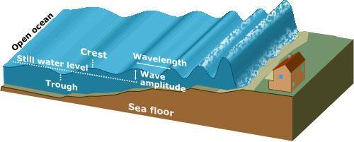
(energy loss is greater with longer wavelengths)
") GEOL 0820 Ramsey Natural Disasters Spring, 2018 LECTURE #9: Tsunami Monitoring & Mitigation Date: 8 February 2018 I. Characteristics (con t): shoaling: o process of wave height increase and breaking as
GEOL 0820 Ramsey Natural Disasters Spring, 2018 LECTURE #9: Tsunami Monitoring & Mitigation Date: 8 February 2018 I. Characteristics (con t): shoaling: o process of wave height increase and breaking as
GREENDALE SECONDARY SCHOOL HUMANITIES DEPARTMENT Geography Elective
 GREENDALE SECONDARY SCHOOL HUMANITIES DEPARTMENT Geography Elective Name: ( ) Class: Secondary Date: Revision for EOY Exam 2015 1) Study Fig. 1 which shows a satellite image of the East African Rift Valley.
Earthquake Hazards. Tsunami
 Earthquake Hazards Tsunami Measuring Earthquakes Two measurements that describe the power or strength of an earthquake are: Intensity a measure of the degree of earthquake shaking at a given locale based
Three Fs of earthquakes: forces, faults, and friction. Slow accumulation and rapid release of elastic energy.
 Earthquake Machine Stick-slip: Elastic Rebound Theory Jerky motions on faults produce EQs Three Fs of earthquakes: forces, faults, and friction. Slow accumulation and rapid release of elastic energy. Three
Disclaimer. This report was compiled by an ADRC visiting researcher (VR) from ADRC member countries.
 from ADRC member countries.") Disclaimer This report was compiled by an ADRC visiting researcher (VR) from ADRC member countries. The views expressed in the report do not necessarily reflect the views of the ADRC. The boundaries and
Disclaimer This report was compiled by an ADRC visiting researcher (VR) from ADRC member countries. The views expressed in the report do not necessarily reflect the views of the ADRC. The boundaries and
Running Head: JAPANESE TSUNAMI 1. Geological Perspective of the Japanese Tsunami
 Running Head: JAPANESE TSUNAMI 1 Geological Perspective of the Japanese Tsunami JAPANESE TSUNAMI 2 JAPANESE TSUNAMI 3 Abstract Humanity is characterized with flaws, so is planet earth. Earthquakes shake
Correlating Radioactive Material to Sea Surface Temperature off the Coast of Japan: The Fukushima Daiichi Nuclear Disaster. Maya R.
 Correlating Radioactive Material to Sea Surface Temperature off the Coast of Japan: The Fukushima Daiichi Nuclear Disaster Maya R. Pincus Department of Geology, University of Puerto Rico-Mayagüez e-mail:
What is an Earthquake?
 Earthquakes What is an Earthquake? Earthquake - sometimes violent shaking of ground caused by movement of Earth s tectonic plates; creates seismic waves Often followed by smaller earthquakes (aftershocks);
Earthquakes & Volcanoes
 Earthquakes & Volcanoes Geology - the study of solid Earth, the rocks of which it is composed, and the processes by which they change geo = Earth; ology = study of Earth s Layers Plate Tectonics - the
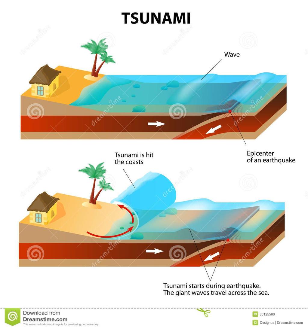
What causes a tsunami?
 Listen: Have this page read to you [1] Have this page read to you [2] A tsunami is a series of waves in the sea caused by a movement on the sea floor. New Zealand is at risk from tsunami because it has
Name Date Class. radiate in all directions, carrying some of the. of plate boundaries have different usual patterns of.
 Chapter Outline Earthquakes CHAPTER 6 Lesson 1: Earthquakes and Plate Boundaries A. What is an earthquake? 1. A(n) is the rupture and sudden movement of rocks along a fault. A fault is a fracture surface
Earthquake Hazards. Tsunami
 Earthquake Hazards Tsunami Review: What is an earthquake? Earthquake is the vibration (shaking) and/or displacement of the ground produced by the sudden release of energy. The point inside the Earth where
Earthquakes presentation Teacher s Notes
 Earthquakes presentation Teacher s Notes Key concepts: To understand that the Earth is made from 4 different layers To understand why earthquakes happen To understand why earthquakes usually happen at
Earthquakes and Earth s Interior
 - What are Earthquakes? Earthquakes and Earth s Interior - The shaking or trembling caused by the sudden release of energy - Usually associated with faulting or breaking of rocks - Continuing adjustment
"The Big One" by sea and not by land
 "The Big One" by sea and not by land By Los Angeles Times, adapted by Newsela staff on 03.24.14 Word Count 629 Surfer Lee Johnson emerges from the water at San Onofre State Beach, Calif., with the twin
Available online at ScienceDirect. Nuclear power plant explosions at Fukushima-Daiichi. Takashi Tsuruda*
 Available online at www.sciencedirect.com ScienceDirect Procedia Engineering 62 ( 2013 ) 71 77 The 9 th Asia-Oceania Symposium on Fire Science and Technology Nuclear power plant explosions at Fukushima-Daiichi
Purpose of the seminar
 Earthquake disaster preparedness June 24, 2008 Koshun Yamaoka Research Center for Seismology, Volcanology and Disaster Mitigation Graduate School of Environmental Studies Nagoya University Purpose of the
Year 9 Revision. The exam will be based on two topics: Natural hazards and Population. The Exam
 Year 9 Revision The exam will be based on two topics: Natural hazards and Population This document is designed to help you revise. You should use it alongside your class notes. In places there are some
The 2011 Tohoku earthquake and dams
 The 2011 Tohoku earthquake and dams N. Matsumoto & T. Sasaki Japan Dam Engineering Center, Japan T. Ohmachi Tokyo Institute of Technology, Japan ABSTRACT: The magnitude 9.0 Tohoku earthquake occurred on
Earthquakes. These icons indicate that teacher s notes or useful web addresses are available in the Notes Page.
 Earthquakes These icons indicate that teacher s notes or useful web addresses are available in the Notes Page. This icon indicates the slide contains activities created in Flash. These activities are not
UK agencies warn of serious disease after disaster
 UK agencies warn of serious disease after disaster There is a risk of serious outbreaks of disease in the aftermath of the Nepal earthquake, aid agencies have warned. A lack of shelter, contaminated water
9.3. Earthquakes. Earthquakes at Divergent Boundaries
 9.3 Earthquakes Preview the headings on these two pages. What can you say about where earthquakes occur? As the plates that make up Earth s crust move, the rough edges lock together. Over time, pressure
Introduction to Environmental Geology, 5e Case History: Indonesian Tsunami Indonesian Tsunami (2) Introduction Historic Tsunamis
 Introduction Historic Tsunamis") 1 2 3 4 5 6 7 8 9 Introduction to Environmental Geology, 5e Chapter 7 Tsunami Case History: Indonesian Tsunami December 26, 2004, within a few hours, close to 250,000 people were killed With no warning
1 2 3 4 5 6 7 8 9 Introduction to Environmental Geology, 5e Chapter 7 Tsunami Case History: Indonesian Tsunami December 26, 2004, within a few hours, close to 250,000 people were killed With no warning
Seismic Activity and Crustal Deformation after the 2011 Off the Pacific Coast of Tohoku Earthquake
 J-RAPID Symposium March 6-7, 2013 Seismic Activity and Crustal Deformation after the 2011 Off the Pacific Coast of Tohoku Earthquake Y. Honkura Tokyo Institute of Technology Japan Science and Technology
7.3 Magnitude Earthquake Strikes Iran-Iraq Border
 7.3 Magnitude Earthquake Strikes Iran-Iraq Border KEY POINTS A magnitude 7.3 earthquake has struck the Iran-Iraq border with at least 348 fatalities reported. Thousands more have been injured and many
Magnitude 7.6 SOUTH OF IQUIQUE, CHILE
 A powerful aftershock struck off northern Chile prompting an evacuation of the coastal area and raising fears of a tsunami. This magnitude 7.6 earthquake is the largest of a series of aftershocks following
THE 2011 TOHOKU EARTHQUAKE IN JAPAN. VSU Lyuben Karavelov, Sofia, Bulgaria. Key words: Tohoku earthquake, strong ground motion, damage
 THE 2011 TOHOKU EARTHQUAKE IN JAPAN Radan Ivanov 1 VSU Lyuben Karavelov, Sofia, Bulgaria Abstract: This earthquake which occurred on March 11, 2011, had a magnitude of 9.0, which places it as the fourth
We have previously looked at artificial seismograms such as this one here.
 We have previously looked at artificial seismograms such as this one here. S P A realistic Seismic Record Each vertical line = 1 minute Each horizontal line = 15 minutes Seismic station PMM is in Parkfield,
Directed Reading. Section: How and Where Earthquakes Happen WHY EARTHQUAKES HAPPEN. Skills Worksheet. 1. Define earthquake.
 Skills Worksheet Directed Reading Section: How and Where Earthquakes Happen 1. Define earthquake. 2. When do earthquakes usually occur? 3. What is a fault? WHY EARTHQUAKES HAPPEN 4. Rocks along both sides
Natural Disasters Spring, LECTURE #8: Earthquake Disasters: Monitoring & Mitigation. Date: 1 Feb 2018 (lecturer: Dr.
 GEOL 0820 Ramsey Natural Disasters Spring, 2018 LECTURE #8: Earthquake Disasters: Monitoring & Mitigation Date: 1 Feb 2018 (lecturer: Dr. Shawn Wright) I. Exam I - Reminder Feb 6 th next class details:
Tsunami waves swept away houses and cars in northern Japan and pushed ships aground.
 Japan was struck by a magnitude 8.9 earthquake off its northeastern coast Friday. This is one of the largest earthquakes that Japan has ever experienced. In downtown Tokyo, large buildings shook violently
This article is provided courtesy of the American Museum of Natural History.
 Avoiding Earthquake Surprises in the Pacific Northwest This article is provided courtesy of the American Museum of Natural History. How Vulnerable Is the Pacific Northwest? Cascadia is a region in the
Collision and transform Boundaries
 Collision and transform Boundaries I. The collision boundary Sometimes when two plates move together they are both continental rather than one being continental and one being oceanic as at the destructive
Natural Disasters. Why Are There Earthquakes? 197 words. The Power of the Earth 221 words. Big Waves! 188 words
 ARTICLE-A-DAY Natural Disasters 6 Articles Check articles you have read: Why Are There Earthquakes? 197 words The Power of the Earth 221 words Big Waves! 188 words The Volcano That Keeps Erupting 228 words
Earthquake Investigation
 Exploration A Earthquake Investigation 1. Obtain a piece of plastic putty and knead it into a rectangular shape. 2. Push the ends of the putty toward the middle. Draw and describe what it looks like below.
Fukushima nuclear power plant damaged by M9 Earthquake with some focus on ocean
 Fukushima nuclear power plant damaged by M9 Earthquake with some focus on ocean Moto Ikeda (Hokkaido Univ. & JAMSTEC) Oceanographic Society of Japan, Earthquake Disaster Working Group Magnitude-9 earthquake
March 11, 2011 Japanese Tsunami
 John Fassell March 11, 2011 Japanese Tsunami An earthquake occurred 30 miles under ground which lifted the seafloor Incoming wave as seen from shore Tsunami up to 130 feet tall in Miyako, JA that averaged
ACADEMIC YEAR SOCIAL STUDIES YR 9 CONCEPT REVIEW NOTES UNIT 2 : EARTHQUAKES & VOLCANOES What are volcanoes and earthquakes like?
 ACADEMIC YEAR 2016-2017 SOCIAL STUDIES YR 9 CONCEPT REVIEW NOTES UNIT 2 : EARTHQUAKES & VOLCANOES What are volcanoes and earthquakes like? Pages 26-27 1) What are you going to learn about in this unit?
NGIAs' roles in successful disaster response
 The Second UN-GGIM-AP Plenary Meeting NGIAs' roles in successful disaster response Japan Teheran Iran 28 October 2013 Shin-ichi SAKABE, Director of International Affairs Division Geospatial Information
Introduction to Environmental Geology, 5e
 Lecture Presentation prepared by X. Mara Chen, Salisbury University Introduction to Environmental Geology, 5e Edward A. Keller Chapter 7 Tsunami Case History: Indonesian Tsunami December 26, 2004, within
Earthquake Source. Kazuki Koketsu. Special Session: Great East Japan (Tohoku) Earthquake. Earthquake Research Institute, University of Tokyo
 Earthquake. Earthquake Research Institute, University of Tokyo") 2012/9/24 17:20-17:35 WCEE SS24.4 Special Session: Great East Japan (Tohoku) Earthquake Earthquake Source Kazuki Koketsu Earthquake Research Institute, University of Tokyo 1 Names and features of the earthquake
2012/9/24 17:20-17:35 WCEE SS24.4 Special Session: Great East Japan (Tohoku) Earthquake Earthquake Source Kazuki Koketsu Earthquake Research Institute, University of Tokyo 1 Names and features of the earthquake
Proposing Effective Method to Develop Common Operational Picture in Disaster Response Utilizing Cloud-based Geospatial Infrastructure
 Proposing Effective Method to Develop Common Operational Picture in Disaster Response Utilizing Cloud-based Geospatial Infrastructure Munenari Inoguchi Research Institute for Natural Hazard & Disaster
Ground motion intensity map of the Tainan earthquake (Central Weather Bureau).
.") Taiwan lies on the boundary between the Eurasian Plate and the Philippine Sea Plate, which are converging at 80 mm per year. The island is the result of uplift caused by the collision of the northern end
Taiwan lies on the boundary between the Eurasian Plate and the Philippine Sea Plate, which are converging at 80 mm per year. The island is the result of uplift caused by the collision of the northern end
Tsunami! Beyond the Book. FOCUS Book
 FOCUS Book Use the engineering design process to design a structure that will protect a coastal town from possible tsunami damage. Brainstorm design ideas for your structure with a group of classmates.
Plate tectonics. Temperature increases towards the centre
 Temperature increases towards the centre Plate tectonics Structure of the Earth Crust Two layers of rock that move on top of the mantle 1. Oceanic Lithosphere heavy rock created at constructive plate boundaries
Montserrat Eruption = Monster rat
 Montserrat Eruption 1997 = Monster rat Small island in the Caribbean sea Montserrat is a small... Soufriere Hills volcano Key facts: Date: 25 th June 1997 (small eruptions began in July 1995) Size: 4.5
Cambridge International Examinations Cambridge International Advanced Subsidiary Level
 Cambridge International Examinations Cambridge International Advanced Subsidiary Level *9524768218* ENVIRONMENTAL MANAGEMENT 8291/12 Paper 1 Lithosphere and Atmosphere October/November 2015 Additional
How to communicate Cascadia Subduction Zone earthquake hazards
 How to communicate Cascadia Subduction Zone earthquake hazards Tom Brocher Research Geophysicist Earthquake Science Center U.S. Geological Survey Menlo Park, California Seattle Post-Intelligencer Lessons
FROM SCIENCE TO ACTION: THE RISK ANALYST INTERMEDIARY
 FROM SCIENCE TO ACTION: THE RISK ANALYST INTERMEDIARY Gordon Woo Rome, 8 October, 2014 Many natural hazard stakeholders Civil protection, police and military authorities Infrastructure utility and transport
Lessons Learned from Past Tsunamis Warning and Emergency Response
 UNESCO IOC CTIC US NOAA ITIC Regional Training Workshop on Strengthening Tsunami Warning and Emergency Response Standard Operating Procedures and the Development of the ICG/CARIBE-EWS PTWC New Enhanced
Forces in Earth s Crust
 Name Date Class Earthquakes Section Summary Forces in Earth s Crust Guide for Reading How does stress in the crust change Earth s surface? Where are faults usually found, and why do they form? What land
Dozens Killed after Earthquake in Lombok, Indonesia
 Dozens Killed after Earthquake in Lombok, Indonesia KEY POINTS 91 people have been killed and hundreds injured after a 6.9-magnitude earthquake struck Lombok, Indonesia on 05 August 2018. Widespread damage
Earth Movement and Resultant Landforms
 Earth Movement and Resultant Landforms Structure of the Earth Lithosphere : earth s crust Asthenosphere : upper mantle zone where material is near its melting point & acts almost like liquid (appprox.
European Fallout from Chernobyl
 European Fallout from Chernobyl Fukushima Reactors: before & after earthquake and tsunami Fukushima reactors 3 & 4 (picture released by Tokyo Electric Power Company) Fukushima Reactor 1 A view inside one
KNOWLEDGE NOTE 5-1. Risk Assessment and Hazard Mapping. CLUSTER 5: Hazard and Risk Information and Decision Making. Public Disclosure Authorized
 Public Disclosure Authorized Public Disclosure Authorized Public Disclosure Authorized Public Disclosure Authorized KNOWLEDGE NOTE 5-1 CLUSTER 5: Hazard and Risk Information and Decision Making Risk Assessment
4-3-1 Earthquake and Tsunami Countermeasures of Tokyo s
 4-3-1 Earthquake and Tsunami Countermeasures of Tokyo s Sewerage Masahiro Hikino* and Gaku Sato** *Planning Section, Planning and Coordinating Division, Bureau of Sewerage, Tokyo Metropolitan Government
Chapter 4. The Earth s Surface: Shaping the crust
 Chapter 4 The Earth s Surface: Shaping the crust Learning outcomes In this chapter you will learn: That the earth is made up of layers Why the earth is shaped as it is What plates are and how they move
Earthquakes. Building Earth s Surface, Part 2. Science 330 Summer What is an earthquake?
 Earthquakes Building Earth s Surface, Part 2 Science 330 Summer 2005 What is an earthquake? An earthquake is the vibration of Earth produced by the rapid release of energy Energy released radiates in all
at IHO IRCC7 Mexico City, Mexico, June 2015
 Report on Japan s Response to Disasters presented by JHOD at IHO IRCC7 Mexico City, Mexico, 01 03 June 2015 JAPAN COAST GUARD Actions against huge earthquake Actions taken by JHOD against the Great East
ADDITIONAL RESOURCES. Duration of resource: 30 Minutes. Year of Production: Stock code: VEA Resource written by: Andrew Clarke BA Dip Tchg
 ADDITIONAL RESOURCES The destructive and unexpected nature of earthquakes has remained a constant threat since civilisation began. Suitable for all secondary audiences, this two-part program firstly examines
Paper Reference. Paper Reference(s) 1312/2F Edexcel GCSE Geography A Foundation Tier. Monday 11 June 2007 Afternoon Time: 1 hour 15 minutes
 1312/2F Edexcel GCSE Geography A Foundation Tier. Monday 11 June 2007 Afternoon Time: 1 hour 15 minutes") Centre No. Paper Reference Surname Initial(s) Candidate No. 1 3 1 2 2 F Signature Paper Reference(s) 1312/2F Edexcel GCSE Geography A Foundation Tier Paper 2F Monday 11 June 2007 Afternoon Time: 1 hour
Centre No. Paper Reference Surname Initial(s) Candidate No. 1 3 1 2 2 F Signature Paper Reference(s) 1312/2F Edexcel GCSE Geography A Foundation Tier Paper 2F Monday 11 June 2007 Afternoon Time: 1 hour
DEVASTATING DAMAGE DUE TO THE 2004 INDIAN OCEAN TSUNAMI AND ITS LESSONS
 DEVASTATING DAMAGE DUE TO THE 2004 INDIAN OCEAN TSUNAMI AND ITS LESSONS Fumihiko Imamura 1 1 Professor, Tsunami Engineering, Disaster Control Research Center, Tohoku University, Japan Email: imamura@tsunami2.civil.tohoku.ac.jp
LOCAL TSUNAMIS: CHALLENGES FOR PREPAREDNESS AND EARLY WARNING
 LOCAL TSUNAMIS: CHALLENGES FOR PREPAREDNESS AND EARLY WARNING HARALD SPAHN 1 1 German Technical Cooperation International Services, Jakarta, Indonesia ABSTRACT: Due to the threat of local tsunamis warning
Cascadia Seismic Event Planning for the Maritime Community
 Cascadia Seismic Event Planning for the Maritime Community Jonathan Allan, Oregon Dept. of Geology and Mineral Industries Presentation to Annual Pacific Northwest Waterways Association Meeting (PNWA) October
Natural Disaster :.JP s Experience and Preparation
 Natural Disaster :.JP s Experience and Preparation 14 March. 2018 Hiro Hotta 1 Where s Japan Japan Puerto Rico earthquakes large enough to feel : 2,000-20,000 times a year typhoons disastrous
Deadly Earthquake Strikes Peru
 Deadly Earthquake Strikes Peru KEY POINTS On 14 January 2018, a magnitude-7.1 earthquake struck off the coast of Peru. At least two people have been reported dead, with dozens more left injured or homeless.
Indian Ocean Tsunami Warning System: Example from the 12 th September 2007 Tsunami
 Indian Ocean Tsunami Warning System: Example from the 12 th September 2007 Tsunami Charitha Pattiaratchi 1 Professor of Coastal Oceanography, The University of Western Australia Email: chari.pattiaratchi@uwa.edu.au
Earthquakes. Beyond the Book. FOCUS Book
 FOCUS Book Model how liquefaction during an earthquake changes Earth s surface and affects buildings. Put sand in a large plastic container. Mix enough water into the sand to make the ground feel firm.
Year 4 Geography Revision Pack Summer 2018 Name
 Year 4 Geography Revision Pack Summer 2018 Name Welcome to your geography revision pack for the upcoming Summer exams. Everything that we have been working on in lessons since Christmas will be covered
Piles for RC/Steel-frame buildings pulled up by tsunami at Onagawa Town, in the March 11 th 2011 East Japan Earthquake
 Piles for RC/Steel-frame buildings pulled up by tsunami at Onagawa Town, in the March 11 th 2011 East Japan Earthquake Kazuo KONAGAI 1, Takashi KIYOTA 2 and Hiroyuki KYOKAWA 3 1 Member of JSCE, Professor,
Level 2 Earth and Space Science, 2017
 91191 911910 2SUPERVISOR S Level 2 Earth and Space Science, 2017 91191 Demonstrate understanding of the causes of extreme Earth events in New Zealand 9.30 a.m. Thursday 30 November 2017 Credits: Four Achievement
Geography Education Challenges Regarding Disaster Mitigation in Japan
 Geography Education Challenges Regarding Disaster Mitigation in Japan Koji OHNISHI 1 University of Toyama, Toyama, JAPAN Hiroshi MITSUHASHI 2 Ministry of Education, Culture, Sports, Science & Technology,
Earthquakes in Oregon: Past, Present & Future. Earthquakes in OREGON: Are we ready for the Big One?
 Earthquakes in Oregon: Past, Present & Future Earthquakes in OREGON: Are we ready for the Big One? Scott Burns Portland State University Department of Geology New Yorker Article: 7/20/15 The Really Big
Risk-based land use and spatial planning
 Risk-based land use and spatial planning Miho OHARA International Centre for Water Hazards and Risk Management (ICHARM) Public Works Research Institute PWRI), Japan Under the auspices of UNESCO Introduction
Paper Reference. Paper Reference(s) 1312/4H Edexcel GCSE Geography A Higher Tier. Monday 11 June 2007 Afternoon Time: 1 hour 15 minutes
 1312/4H Edexcel GCSE Geography A Higher Tier. Monday 11 June 2007 Afternoon Time: 1 hour 15 minutes") Centre No. Paper Reference Surname Initial(s) Candidate No. 1 3 1 2 4 H Signature Paper Reference(s) 1312/4H Edexcel GCSE Geography A Higher Tier Paper 4H Monday 11 June 2007 Afternoon Time: 1 hour 15
Centre No. Paper Reference Surname Initial(s) Candidate No. 1 3 1 2 4 H Signature Paper Reference(s) 1312/4H Edexcel GCSE Geography A Higher Tier Paper 4H Monday 11 June 2007 Afternoon Time: 1 hour 15
Earthquakes. Earthquakes and Plate Tectonics. Earthquakes and Plate Tectonics. Chapter 6 Modern Earth Science. Modern Earth Science. Section 6.
 Earthquakes Chapter 6 Modern Earth Science Earthquakes and Plate Tectonics Section 6.1 Modern Earth Science Earthquakes and Plate Tectonics Earthquakes are the result of stresses in Earth s s lithosphere.
Magnitude 6.5 OFFSHORE NORTHERN CALIFORNIA
 A powerful offshore earthquake that struck near the Northern California coast left a hodgepodge of debris for communities to sort through Sunday but spared residents any serious injury. After 25,000 people
The Eyjafjallajokull volcanic eruption
 Explain the formation of the volcano E15 and the causes of its eruptions. Describe the effects of the 2010 eruption. Make sure you can categorise these according to whether they are primary or secondary
Emergency Management: A Guide for Personal & Family Preparedness. COMFLEACT Yokosuka Emergency Management Office
 Emergency Management: A Guide for Personal & Family Preparedness COMFLEACT Yokosuka Emergency Management Office Computer Desktop Notification System (CDNS) GET NOTIFIED!!! Computer Desktop Notification
Study of the liquefaction phenomenon due to an earthquake: case study of Urayasu city
 Disaster Management and Human Health Risk III 311 Study of the liquefaction phenomenon due to an earthquake: case study of Urayasu city S. Kamao 1, M. Takezawa 1, K. Yamada 1, S. Jinno 1, T. Shinoda 1
Assessment Schedule 2015 Earth and Space Science: Demonstrate understanding of the causes of extreme Earth events in New Zealand (91191)
") NCEA Level 2 Earth and Space Science (91191) 2015 page 1 of 6 Assessment Schedule 2015 Earth and Space Science: Demonstrate understanding of the causes of extreme Earth events in New Zealand (91191) Evidence
NCEA Level 2 Earth and Space Science (91191) 2015 page 1 of 6 Assessment Schedule 2015 Earth and Space Science: Demonstrate understanding of the causes of extreme Earth events in New Zealand (91191) Evidence
JP experience of earthquake, tsunami, and nuclear plant accident
 JP experience of earthquake, tsunami, and nuclear plant accident ccnso Members Meeting 21 June 2011 Hiro Hotta What happened (1) Earthquake Friday, March 11, 2011 14:46 JST Earthquake
Tsunami Seismic Sea Wave. Dr. Wan Zuhairi Wan Yaacob Program Geologi, UKM
 Tsunami Seismic Sea Wave soo-nah-mee Dr. Wan Zuhairi Wan Yaacob Program Geologi, UKM the breaking wave off Kanagawa wood block color print the event s surface wave magnitude, Ms. Historical map of 731
What Are Disasters? The Rescue Kids Trio!
 The Rescue Kids Trio! What Are Disasters? This manual was made possible through funding by the Council of Local Authorities for International Relations. Disasters and emergency preparedness Emergency preparedness
The nature of seismicity: forms and causes Hazards
 The nature of seismicity: forms and causes 3.1.5.4 Hazards What you need to know The nature of seismicity and its relation to plate tectonics. Forms of seismic hazard including earthquakes, shockwaves,
The Three Things You Need to Know About Tsunami Preparedness Patrick Corcoran, Oregon Sea Grant,
 The Three Things You Need to Know About Tsunami Preparedness Patrick Corcoran, Oregon Sea Grant, 10.11.13 NSF/CEETEP Workshop for Coastal Educators, October 11-14, Astoria, OR The Bottom Line Giant Earthquakes
Magnitude 7.1 NEAR THE EAST COAST OF HONSHU, JAPAN
 Japan was rattled by a strong aftershock and tsunami warning Thursday night nearly a month after a devastating earthquake and tsunami flattened the northeastern coast. This earthquake can be considered
Phases of Disaster Response. John Yeaw, Gavin Vanstone, Haochen Wu, Jordan Tyler
 Phases of Disaster Response John Yeaw, Gavin Vanstone, Haochen Wu, Jordan Tyler BP Oil Spill One of the worst man made disasters in human history The BP oil spill occurred in April of 2010 when the Deepwater
M 7.1 EARTHQUAKE 5KM ENE OF RABOSO, MEXICO EXACT LOCATION: N W DEPTH: 51.0KM SEPTEMBER 19, 1:14 LOCAL TIME
 M 7.1 EARTHQUAKE 5KM ENE OF RABOSO, MEXICO EXACT LOCATION: 18.584 N 98.399 W DEPTH: 51.0KM SEPTEMBER 19, 2017 @ 1:14 LOCAL TIME Photo: Eduardo Verdugo / AP Photo: Alfredo Estrella/ Agence France-Presse/
Lecture Outline Wednesday-Monday April 18 23, 2018
 Lecture Outline Wednesday-Monday April 18 23, 2018 Questions? Lecture Final Exam Lecture Section 1 Friday May 4, 8:00-10:00am Lecture Section 2 Friday May 4, 3:10-5:10 pm Final Exam is 70% new material
Quake in Indonesia. A series of earthquakes strike the island nation.
 Quake in Indonesia A series of earthquakes strike the island nation. A series of earthquakes rocked the Indonesian island of Sumatra in Southeast Asia. On March 6, 2007, a 6.3-magnitude 1 quake destroyed
Surviving the Big One: Understanding and Preparing for a Major Earthquake in Western Oregon
 Surviving the Big One: Understanding and Preparing for a Major Earthquake in Western Oregon May 21, 2013 City of Salem Salem Public Library Althea Rizzo, Geological Hazards Program Coordinator Oregon Emergency