Earthquakes Physical Geology 2017 Part 1: Exploring Earthquake distributions. Home butto California Earthquakes: 1) 2) 3) above
|
|
|
- Colleen Stokes
- 6 years ago
- Views:
Transcription

1 Earthquakes Physical Geology 2017 Adapted from a lab by Jennifer Wenner This lab is designed to give you experience exploring seismicity associated with different plate boundaries. You will examine seismograms and determine the location of an earthquake s epicenter using arrival times of P and S waves. You will also relate the types of hazards and depths of earthquakes to the types of plate boundaries with which they are associated. Part 1: Exploring Earthquake distributions. 1. Log into Titan WiFi on the ipad a. Select Settings in the lower left b. Turn on the WiFi and choose Titan WiFi c. Log in using your TitanApps login information 2. Push the Home button to return to the home page 3. Open Safari (bottom menu) 4. Open the IRIS Earthquake Browser ( 5. Select the Max quakes dropdown menu (upper right) as Select Priority (just below Max Quakes) to read Largest. Select on for Show Plates. 7. Hit Apply and play around with it and familiarize yourself with its features. California Earthquakes: 1) Zoom into the western US, so that California and Nevada are in the window. 2) Describe the pattern of Earthquakes in California (where do they occur?). 3) Examine the pattern of earthquakes in WESTERN California and just off the coast of Oregon. a) What kind of plate boundary is present in Western California that would explain the distribution of earthquakes there? b) Draw arrows on the map above that shows the sense of motion on the fault that runs the length of California (Pacific plate is moving north relative to North America). 1
 in the upper part of the crust. a) Draw arrows in this region showing the type of stress that dominates.")
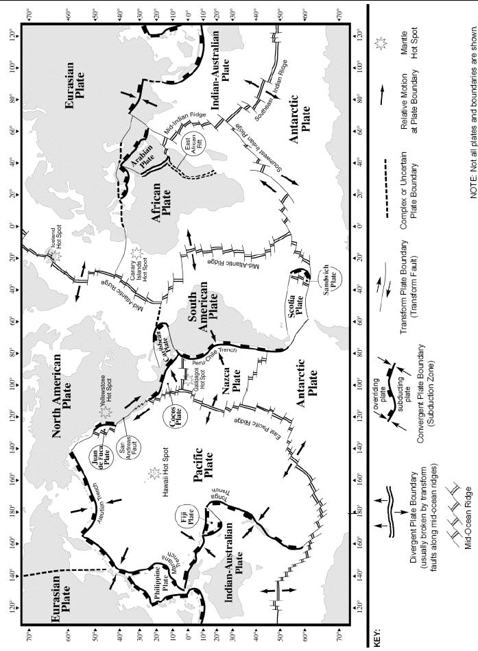
2 c) What type of fault is this? (normal; reverse; thrust; right-lateral strike slip; left-lateral strike slip) 4) Examine the pattern of earthquakes in EASTERN California along the border with Nevada. Eastern California is dominated by extension (pulling apart) in the upper part of the crust. a) Draw arrows in this region showing the type of stress that dominates. b) What type of faults would you expect to dominate in this part of the US? (normal; reverse; thrust; strike slip) Indonesian Earthquakes: Using IRIS Earthquake Browser. Zoom back out and then zoom in so that the island of Sumatra (in Indonesia south of Malaysia & near Singapore) is visible. Be sure to select Earliest Available in the Time Range and All Values in the Magnitude Range. 1) What kind of plate boundary is dominant in Sumatra that would explain the distribution of earthquakes there? 2) Describe the pattern of earthquakes in and around Sumatra. As you go north and away from the convergent plate boundary, do earthquakes get deeper or shallower? [Feel free to use the 3D viewer.] 3) Draw arrows on the map above showing the sense of motion on the fault (in yellow at right) that affects Sumatra. 4) How might you expect hazards associated with earthquakes in Sumatra to differ from those associated with California earthquakes? What hazards would be the same? 2
 Looking at the earthquakes north and south of Iceland, what kind of plate boundary in this area would explain the distribution of earthquakes there?")
3 Iceland Earthquakes: Using IRIS Earthquake Browser. Zoom back out and then zoom in so that Iceland (in the North Atlantic) is centered and visible. 1) Looking at the earthquakes north and south of Iceland, what kind of plate boundary in this area would explain the distribution of earthquakes there? 2) Draw arrows on the map above showing the direction of plate motion that leads to the observed earthquakes. 3) Zooming in on the island of Iceland, adjust the magnitude range to view earthquakes greater than 5.0 (under Magnitude Range, uncheck All Values and make the range 5 mag 10). Where in Iceland are most of quakes over magnitude 5.0 located? 4) Adjust the time range for your earthquakes to find the mag 5.0 earthquakes since Do this by unchecking Earliest Available and adding to the box. (This means show earthquakes since Jan 1, 2014 ). Use the time range to determine which year since 2014 had the most earthquakes 5.0. Which year was it? 5) What do you think happened to produce the earthquakes in Iceland in the year from the previous question? Justify your answer. 6) What is the magnitude of the largest recorded earthquake in Iceland? 7) Based on the 3 locations you investigated, what kind of plate boundary do you think has the greatest earthquake hazard? Which gives the least earthquake hazard for people? 3
4 Part 2: The Sumatra Earthquake and Tsunami December 26, 2004 Adapted from a lab by Dave Robison and Steve Kluge Introduction: Approximately 280,000 people died as a result of the 9.0 magnitude earthquake and ensuing tsunami associated with the 2004 Sumatra Earthquake. The event marked the second-most most devastating natural disaster to hit the world in the last century. In this lab you ll study seismograms from 3 different seismic stations that record the magnitude 9.0 Sumatra earthquake of December 26 th, By comparing the arrival times of the P and S waves on each seismogram, you ll be able to determine the distance from the epicenter to each station. Using those data, you can accurately map the location of the epicenter of the earthquake. Once you ve located the epicenter, you ll calculate the position of the tsunami generated by the quake at one hour intervals. From those determinations, you can predict how much time people had before the tsunami crashed onto their shores. Finding the Epicenter 1. Label the following countries on MAP 1: (Use whatever resources you need) India, Sri Lanka, Somalia, Sumatra (Indonesia), Myanmar, Thailand, 2. Read the time of the P and S waves at each station and place that information in your data table below. Read each arrival time to the nearest second. Note: The first vertical line marks the P-wave arrival and the second vertical line marks the S-wave arrival time. 3. Subtract the P-wave arrival time from the S-wave arrival time (S-P), though there is a more direct way to get that information off the seismogram. Double-check and record your results in DATA TABLE Use the P and S wave travel-time curves to find the distance from each station to the earthquake epicenter. Do this by finding the unique epicenter distance where the difference in the P and S wave travel times is exactly equal to the difference you calculated from the seismogram (NOTE: scales on seismograms are different than on the P-S curve). Record that distance in the last column of the data table. 5. On the The Great Sumatra Earthquake (Map 1) map, use the map scale and your compass to draw circles around each station of a radius equal to the epicenter distances that you just determined using the travel time curves. 6. The intersection of the 3 circles marks the epicenter of the quake. Label it Epicenter on your map. DATA TABLE 1: Seismograph Station P-wave Arrival S-wave Arrival PALK DGAR COCO Time Difference (S P) Epicenter Distance Questions/Activities: 1. Which seismic station is located farthest from the epicenter? a. How could you have determined which was farthest by simply looking the seismograms? 4
5 5
 http://ida.ucsd.")

 Islands, Australia: Coordinates: (12.2 S, 96.")
6 SEISMOGRAMS for Part 1 PALK, Pallekele, Sri Lanka: Coordinates: (7.3 N, 80.7 E) DGAR, Diego Garcia, British Indian Ocean Territory: Coordinates: (7.4 S, 72.5 E) COCO, Cocos (Keeling) Islands, Australia: Coordinates: (12.2 S, 96.8 E) 6
")
7 (Chart from the New York State Earth Science Reference Tables) 7
8 b. Why do you need at least three seismic stations to find the epicenter of the quake? 2. The quake occurred on a tectonic plate boundary. Refer to the global tectonic plate map (Map 2) to answer the following questions: a. Between which 2 tectonic plates did this quake occur? b. How are the plates moving relative to each other in the area of the quake? c. What term describes this kind of plate boundary? 3. The focus of the quake occurred at a depth of about 30 km (18 mi) and about 150 km (90 mi) northeast of the trench (see Map 2). a. Explain how this information helps you to determine which plate is being subducted. Predicting the Arrival of Tsunami Waves The speed at which a tsunami moves through the ocean is dependent largely on the depth of the ocean. The tsunami generated by this quake moved at an average speed of about 600 kilometers per hour. Though tsunamis travel fast, their wave heights are not very high in the open ocean and are at most only a few feet, but they can have wavelengths over 100 km long (!), so they are often unnoticed as they pass beneath ships at sea. As they approach shallow water near the coast, however, front of the tsunami waves slows down, the trailing portion of the wave runs into the front shortening the wavelength, and heights may increase to many meters. ( Assume the tsunami generated by the Great Sumatra Quake traveled 600 km/hr in the open ocean. On Map 1, draw and label circles around the epicenter showing the distance the tsunami had traveled in 1 hour, 2 hours, 3 hours, and 4 hours. (You should have four labeled circles surrounding your epicenter representing the position of the leading edge of the tsunami as it traveled through the ocean after the earthquake occurred) 1. Note the number of people killed by the tsunami in the following countries: India: estimated ~18,000 Sri Lanka: estimated ~35,000 Thailand: estimated~8,000 Indonesia: estimated ~170,000 Myanmar: estimated ~400 Somalia: estimated ~300 8
9 2. Using MAP 1 and the tsunami circles that you drew, estimate the amount of time that these countries had before the tsunami crashed onto their shores. India Sri Lanka Thailand Indonesia Myanmar Somalia Why do you suppose Indonesia s casualty rate was so high? 3. Assume that you live in small town on the coast of Oregon. Examine the region around Oregon on Map 2. What geologic conditions exist in that part of the world that might cause a tsunami? 4. Tsunamis are likely to occur when large earthquakes occur on the seafloor, as happens in the Pacific Ocean. The 2011 Honshu (Japan) earthquake caused a tsunami that devastated parts of coastal Japan, ~30-90 minutes after the quake. Locate Japan on Map 2. Why might a tsunami warning system fail to alert people in a tsunami zone after a major earthquake strikes? 9
10 MAP 2 10
Name: Date: Bell: The Sumatra Earthquake and Tsunami December 26, 2004
 Name: Date: Bell: The Sumatra Earthquake and Tsunami December 26, 2004 Introduction: The incredible damage and tragic loss of life resulting from the 9.0 magnitude earthquake and ensuing tsunami was shocking
RR#8 - Free Response
 Base your answers to questions 1 through 4 on the passage and the map below and on your knowledge of Earth science. The map indicates the epicenter (*) of a major earthquake that occurred at 38 N 142 E.
Earthquake Investigation
 Exploration A Earthquake Investigation 1. Obtain a piece of plastic putty and knead it into a rectangular shape. 2. Push the ends of the putty toward the middle. Draw and describe what it looks like below.
News Release December 30, 2004 The Science behind the Aceh Earthquake
 News Release December 30, 2004 The Science behind the Aceh Earthquake PASADENA, Calif. - Kerry Sieh, the Robert P. Sharp Professor of Geology at the California Institute of Technology and a member of Caltech's
Once you have opened the website with the link provided choose a force: Earthquakes
 Name: Once you have opened the website with the link provided choose a force: Earthquakes When do earthquakes happen? On the upper left menu, choose number 1. Read What is an Earthquake? Earthquakes happen
Objective: You will learn to interpret a seismogram and, using differences in seismic waves, locate the epicenter of an earthquake.
 Earth Science Dynamic Crust Name Period Finding Epicenters Lab# Introduction: Earthquakes occur when there is movement along a fault. The friction between rock masses rubbing against one another generates
The Indian Ocean. Copyright 2010 LessonSnips
 The Indian Ocean One of the five major geographic divisions of the world s ocean, the Indian Ocean is located in the Eastern Hemisphere. The Indian Ocean is bounded by three continents: Africa to the west,
Magnitude 7.9 SE of KODIAK, ALASKA
 A magnitude 7.9 earthquake occurred at 12:31 am local time 181 miles southeast of Kodiak at a depth of 25 km (15.5 miles). There are no immediate reports of damage or fatalities. Light shaking from this
7.1 FIJI 1, :57:22 UTC
 A magnitude 7.1 earthquake struck 141 km (88 miles) northeast of Ndoi Island, Fiji, and 313 km (194 mi) west-northwest of Nuku alofa, Tonga according to the US Geological Survey, but there were no reports
Earthquakes 11/14/2014. Earthquakes Occur at All Boundaries. Earthquakes. Key Aspects of an Earthquake. Epicenter. Focus
 Earthquakes Earthquakes Caused by friction and movement between Earth s tectonic plates A release of force Often caused by a catch between two plates As plates slide by, they stick to each other When the
Disclaimer. This report was compiled by an ADRC visiting researcher (VR) from ADRC member countries.
 from ADRC member countries.") Disclaimer This report was compiled by an ADRC visiting researcher (VR) from ADRC member countries. The views expressed in the report do not necessarily reflect the views of the ADRC. The boundaries and
Disclaimer This report was compiled by an ADRC visiting researcher (VR) from ADRC member countries. The views expressed in the report do not necessarily reflect the views of the ADRC. The boundaries and
Geology 101 Study Guide #4
 Geology 101 Study Guide #4 Our last unit is the study of the earthquakes, the Earth s interior and plate tectonics. We live in a region which has been added on to North America through plate tectonics.
Magnitude 7.5 NEW BRITAIN REGION, PAPUA NEW GUINEA
 A magnitude 7.5 earthquake struck off the eastern coast of Papua New Guinea on Tuesday, approximately 130 km (81 mi) southsouthwest of Kokopo at a depth of 42 km (26.1 mi). There are reports of some structural
Magnitude 7.0 NEW CALEDONIA
 A magnitude 7.0 earthquake has occurred 82km ENE of Maré Island, the secondlargest of the Loyalty Islands in the archipelago of New Caledonia. The initial report of the magnitude and shallow 10km depth
Magnitude 7.7 QUEEN CHARLOTTE ISLANDS REGION
 A major 7.7 magnitude earthquake struck at 8:04 PM local time in western British Columbia, Canada. The epicenter is located on Moresby Island, the southern large island in the Queen Charlotte Islands region.
Preparation for Future Earthquake and Tsunami Hazards: Lessons Learned from the 2004 Sumatra-Andaman Earthquake and the Asian Tsunami
 First International Conference of Aceh and Indian Ocean Studies Organized by Asia Research Institute, National University of Singapore & Rehabilitation and Construction Executing Agency for Aceh and Nias
Magnitude 7.1 SOUTH SANDWICH ISLANDS
 A magnitude 7.1 earthquake occurred at a depth of 164.7 km (102 miles) in the South Sandwich Islands, an uninhabited British territory off the coast of Argentina in the southern Atlantic Ocean. Antarctica
Earthquake Hazards. Tsunami
 Earthquake Hazards Tsunami Review: What is an earthquake? Earthquake is the vibration (shaking) and/or displacement of the ground produced by the sudden release of energy. The point inside the Earth where
Dynamic Crust Practice
 1. Base your answer to the following question on the cross section below and on your knowledge of Earth science. The cross section represents the distance and age of ocean-floor bedrock found on both sides
GEOLOGY MEDIA SUITE Chapter 13
 UNDERSTANDING EARTH, SIXTH EDITION GROTZINGER JORDAN GEOLOGY MEDIA SUITE Chapter 13 Earthquakes 2010 W.H. Freeman and Company Three different types of seismic waves are recorded by seismographs Key Figure
We have previously looked at artificial seismograms such as this one here.
 We have previously looked at artificial seismograms such as this one here. S P A realistic Seismic Record Each vertical line = 1 minute Each horizontal line = 15 minutes Seismic station PMM is in Parkfield,
Geology Topics. Unit 6 Notes
 Geology Topics Unit 6 Notes Composition of the Earth Earth is layered due to density differences. Crust thin outer layer, solid, made up of continental and oceanic crust Mantle rocky layer below the crust
Earthquake information
 Name: Date: Block Earthquake information The graph below shows travel time in minutes and distance traveled for primary and secondary waves. Primary and secondary waves start at the same time but do not
Magnitude 7.3 OFFSHORE EL SALVADOR
 A magnitude 7.3 earthquake struck off the Pacific coast of Central America late Monday night, early reports indicate one death. The earthquake occurred at a depth of 40 km (24.9 miles). Its epicenter was
Lessons from the 2004 Sumatra earthquake and the Asian tsunami
 Lessons from the 2004 Sumatra earthquake and the Asian tsunami Kenji Satake National Institute of Advanced Industrial Science and Technology Outline 1. The largest earthquake in the last 40 years 2. Tsunami
Magnitude 7.0 PAPUA, INDONESIA
 A 7.0 magnitude earthquake struck eastern Indonesia's mountainous West Papua province on Saturday but there were no immediate reports of casualties or damage. The region is sparsely populated. According
Earthquake Hazards. Tsunami
 Earthquake Hazards Tsunami Review: What is an earthquake? Earthquake is the vibration (shaking) and/or displacement of the ground produced by the sudden release of energy. The point inside the Earth where
Advisors: Arcadii Grinshpan, Mathematics and Statistics Rocco Malservisi, School of Geosciences. Problem Suggested By: Rocco Malservisi
 Undergraduate Journal of Mathematical Modeling: One + Two Volume 8 2018 Spring 2018 Issue 2 Article 6 Tsunami Waves Samantha Pennino University of South Florida Advisors: Arcadii Grinshpan, Mathematics
Earthquake Hazards. Tsunami
 Earthquake Hazards Tsunami Measuring Earthquakes Two measurements that describe the power or strength of an earthquake are: Intensity a measure of the degree of earthquake shaking at a given locale based
Magnitude 7.1 PERU. There are early reports of homes and roads collapsed leaving one dead and several dozen injured.
 A magnitude 7.1 earthquake has occurred offshore Peru. The earthquake struck just after 4 a.m. local time and was centered near the coast of Peru, 40 km (25 miles) south-southwest of Acari, Peru at a depth
An Earthquake is a rapid vibration or shaking of the Earth s crust created by a release in energy from sudden movement of a part of a plate along a
 An Earthquake is a rapid vibration or shaking of the Earth s crust created by a release in energy from sudden movement of a part of a plate along a fault. Energy released radiates in all directions from
Indian Ocean Tsunami Warning System: Example from the 12 th September 2007 Tsunami
 Indian Ocean Tsunami Warning System: Example from the 12 th September 2007 Tsunami Charitha Pattiaratchi 1 Professor of Coastal Oceanography, The University of Western Australia Email: chari.pattiaratchi@uwa.edu.au
5. EARTHQUAKES AND EARTH S INTERIOR
 LAST NAME (ALL IN CAPS): FIRST NAME: 5. EARTHQUAKES AND EARTH S INTERIOR EARTHQUAKE An earthquake is ground shaking caused by sudden and rapid movement of one block of rock slipping past another along
C) 10:20:40 A) the difference between the arrival times of the P -wave and the S -wave
 10:20:40 A) the difference between the arrival times of the P -wave and the S -wave") 1. The arrival time of the first earthquake P-wave at a seismograph station was 10:11:20 (hours:minutes:seconds). If the epicenter of the earthquake is 8000 km away, what was the approximate arrival time
1. The arrival time of the first earthquake P-wave at a seismograph station was 10:11:20 (hours:minutes:seconds). If the epicenter of the earthquake is 8000 km away, what was the approximate arrival time
Chapter 15. Earthquakes and Plate Tectonics. what s the connection? At the boundaries friction causes plates to stick together.
 Chapter 15 Earthquakes and Plate Tectonics what s the connection? As with volcanoes, earthquakes are not randomly distributed over the globe At the boundaries friction causes plates to stick together.
Earthquakes and Earthquake Hazards Earth - Chapter 11 Stan Hatfield Southwestern Illinois College
 Earthquakes and Earthquake Hazards Earth - Chapter 11 Stan Hatfield Southwestern Illinois College What Is an Earthquake? An earthquake is the vibration of Earth, produced by the rapid release of energy.
Earthquakes Modified
 Plate Tectonics Earthquakes Modified Recall that the earth s crust is broken into large pieces called. These slowly moving plates each other, each other, or from each other. This causes much on the rocks.
1. Name at least one place that the mid-atlantic Ridge is exposed above sea level.
 Interpreting Tectonic and Bathymetric Maps. The purpose of this lab is to provide experience interpreting the bathymetry of the seafloor in terms of tectonic and geologic settings and processes. Use the
Figure Diagram of earth movements produced by (a) P-waves and (b) S-waves.
 P-waves and (b) S-waves.") Geology 101 Name(s): Lab 10: Earthquakes When the stresses in a rock (which may or may not already be faulted) exceed the tensile strength of the rock, the rock ruptures at a point called the focus or
Geology 101 Name(s): Lab 10: Earthquakes When the stresses in a rock (which may or may not already be faulted) exceed the tensile strength of the rock, the rock ruptures at a point called the focus or
Lab Activity Locating Epicenters
 Lab Activity Locating Epicenters Key Features: Analyzing Seismograms P-waves & S-waves Using ESRT page 11 Drawing Epicenter Circles By Kaitlin Coder https://www.teacherspayteachers.com/store/nys-earth-science-and-living-environment-regents
How Do We Know Where an Earthquake Originated? Teacher's Guide
 How Do We Know Where an Earthquake Originated? Teacher's Guide Standard Addressed: Grades 6-8: Scientific Inquiry 1 B/1, 2 Mathematical Inquiry 2 C/2 Technology and Science 3 A/2 Processes that shape the
Dynamic Earth A B1. Which type of plate boundary is located at the Jordan Fault? (1) divergent (3) convergent (2) subduction (4) transform
 divergent (3) convergent (2) subduction (4) transform") Dynamic Earth A B1 1. The edges of most lithospheric plates are characterized by (1) reversed magnetic orientation (2) unusually rapid radioactive decay (3) frequent volcanic activity (4) low P-wave and
Dynamic Earth A B1 1. The edges of most lithospheric plates are characterized by (1) reversed magnetic orientation (2) unusually rapid radioactive decay (3) frequent volcanic activity (4) low P-wave and
Three Fs of earthquakes: forces, faults, and friction. Slow accumulation and rapid release of elastic energy.
 Earthquake Machine Stick-slip: Elastic Rebound Theory Jerky motions on faults produce EQs Three Fs of earthquakes: forces, faults, and friction. Slow accumulation and rapid release of elastic energy. Three
Magnitude 7.5 NEW BRITAIN REGION, PAPUA NEW GUINEA
 A magnitude 7.5 earthquake struck off the eastern coast of Papua New Guinea on Sunday, approximately 54 km (33 miles) southeast of Kokopo. Residents reported strong ground shaking for about five minutes.
The map below shows the locations of earthquakes and volcanoes
 45 Understanding Plate Boundaries R E A D I N G The map below shows the locations of earthquakes and volcanoes on the earth s surface. Today, many of the world s most active volcanoes are located around
ES Ch 19 Earthquakes 1
 Chapter 19 - Earthquakes Objectives 1. Define stress vs. strain as they apply to rocks. 2. Define faults. 3. Contrast types of seismic waves-3 types according to their type of movement, speed, location
Beneath our Feet: The 4 Layers of the Earty by Kelly Hashway
 Beneath our Feet: The 4 Layers of the Earty by Kelly Hashway The Earth is more than a giant ball made up of dirt, rocks, and minerals. The Earth may look like a giant ball from when looking at it from
Tectonic Forces Simulation: Earthquakes Activity One
 Tectonic Forces Simulation: Earthquakes Activity One Introduction If you marked all the earthquakes from the past century on a world map, you'd notice that most tend to occur along certain lines around
Earthquakes. Building Earth s Surface, Part 2. Science 330 Summer What is an earthquake?
 Earthquakes Building Earth s Surface, Part 2 Science 330 Summer 2005 What is an earthquake? An earthquake is the vibration of Earth produced by the rapid release of energy Energy released radiates in all
Introduction to Environmental Geology, 5e Case History: Indonesian Tsunami Indonesian Tsunami (2) Introduction Historic Tsunamis
 Introduction Historic Tsunamis") 1 2 3 4 5 6 7 8 9 Introduction to Environmental Geology, 5e Chapter 7 Tsunami Case History: Indonesian Tsunami December 26, 2004, within a few hours, close to 250,000 people were killed With no warning
1 2 3 4 5 6 7 8 9 Introduction to Environmental Geology, 5e Chapter 7 Tsunami Case History: Indonesian Tsunami December 26, 2004, within a few hours, close to 250,000 people were killed With no warning
Magnitude 7.6 HONDURAS
 A magnitude 7.6 earthquake has occurred in the Caribbean between Honduras and the Cayman Islands approximately 125 miles (202 km) north-northeast of Barra Patuca, Honduras, and 188 miles (303 km) southwest
LAB 9: Earthquakes & Seismic Activity
 LAB 9: Earthquakes & Seismic Activity Objectives Identify P, S, and surface waves on a simple seismogram Locate the epicenter of an earthquake using seismograms and travel times curves Describe how the
Name Date Class. radiate in all directions, carrying some of the. of plate boundaries have different usual patterns of.
 Chapter Outline Earthquakes CHAPTER 6 Lesson 1: Earthquakes and Plate Boundaries A. What is an earthquake? 1. A(n) is the rupture and sudden movement of rocks along a fault. A fault is a fracture surface
Plates & Boundaries The earth's continents are constantly moving due to the motions of the tectonic plates.
 Plates & Boundaries The earth's continents are constantly moving due to the motions of the tectonic plates. As you can see, some of the plates contain continents and others are mostly under the ocean.
EQ Monitoring and Hazards NOTES.notebook. January 07, P-wave. S-wave. surface waves. distance
 Earthquake Monitoring and Hazards Reading a Seismogram General guidelines: P-wave First disruption of trace = Second disruption of trace = surface waves Largest disruption of trace = Not the distance to
Introduction to Environmental Geology, 5e
 Lecture Presentation prepared by X. Mara Chen, Salisbury University Introduction to Environmental Geology, 5e Edward A. Keller Chapter 7 Tsunami Case History: Indonesian Tsunami December 26, 2004, within
What is an Earthquake?
 Earthquakes What is an Earthquake? Earthquake - sometimes violent shaking of ground caused by movement of Earth s tectonic plates; creates seismic waves Often followed by smaller earthquakes (aftershocks);
Magnitude 7.4 SOUTH GEORGIA ISLAND REGION
 A magnitude 7.4 earthquake occurred in the South Georgia Island Region. South Georgia Island is a British territory in the South Atlantic Ocean that lies about 800 miles east of the Falkland Islands. It
Inquiry: Sumatran earthquakes with GPS Earth Science Education
 Inquiry: Sumatran earthquakes with GPS Earth Science Education www.earthobservatory.sg Preparation: Before doing this investigation, complete two introductory investigations using GPS data from UNAVCO
Magnitude 7.5 PALU, INDONESIA
 A magnitude 7.5 earthquake occurred 80.8 km (50.2 mi) north of Palu, Indonesia at a depth of 10 km (6.2 miles). This earthquake triggered a tsunami with wave heights up to 2 m (6.6 ft) that an official
Dynamic Planet. Student Name. Teacher
 Dynamic Planet Student Name Teacher The Dynamic Planet 1. What makes our planet dynamic? 2. Draw the Earth and its systems: 3. What makes up the four systems of our Earth? Geosphere: Hydrosphere: Atmosphere:
A. Locate the Epicenter
 Name: Block: Earthquake Lab The goal of this portion of the lab is to learn how recording of earthquakes seismograms are used to locate earthquakes, determine their magnitudes, and to understand the sense
Magnitude 7.5 PAPUA NEW GUINEA
 A magnitude 7.5 earthquake occurred 33 kilometers (20 miles) southwest of Tari, Papua New Guinea, at a depth of 35 km (22 miles). Papua New Guinea is located on the eastern half of the island of New Guinea,
Not all eruptions are the same. Sometimes, there is a huge explosion. The hot magma shoots
 Natural Disasters A natural disaster is an event that happens in nature. It is an event that can cause a lot of damage. Volcanoes, earthquakes, and tsunamis are all natural disasters. Volcanoes A volcano
Dynamic Crust Regents Review
 Name Dynamic Crust Regents Review Base your answers to questions 1 through 3 on the table below, which lists the location of some earthquakes, their Richter magnitude, and their year of occurrence. Data
San Andreas Movie Can It Happen?
 San Andreas Movie Can It Happen? Learning Objectives (LO) Lecture 14: Faults and Quakes Read: Chapter 10 and 11 Homework #12 due Thursday 12pm What we ll learn today:! 1. Compare strike-slip to dip-slip
Magnitude 7.0 N of ANCHORAGE, ALASKA
 A magnitude 7.0 earthquake occurred just before 8:30 am local time 8 miles north of Anchorage at a depth of 40.9 km (25.4 miles). There are reports of major infrastructure damage and damage to many homes
Topic 5: The Dynamic Crust (workbook p ) Evidence that Earth s crust has shifted and changed in both the past and the present is shown by:
 Evidence that Earth s crust has shifted and changed in both the past and the present is shown by:") Topic 5: The Dynamic Crust (workbook p. 65-85) Evidence that Earth s crust has shifted and changed in both the past and the present is shown by: --sedimentary horizontal rock layers (strata) are found
Topic 5: The Dynamic Crust (workbook p. 65-85) Evidence that Earth s crust has shifted and changed in both the past and the present is shown by: --sedimentary horizontal rock layers (strata) are found
Magnitude 8.2 FIJI. A magnitude 8.2 earthquake occurred km (226.7 mi) E of Suva, Fiji at a depth of km (350 miles).
 E of Suva, Fiji at a depth of km (350 miles).") A magnitude 8.2 earthquake occurred 364.8 km (226.7 mi) E of Suva, Fiji at a depth of 563.4 km (350 miles). There is no risk of a tsunami from an earthquake at this depth. Images courtesy of Google The
A magnitude 8.2 earthquake occurred 364.8 km (226.7 mi) E of Suva, Fiji at a depth of 563.4 km (350 miles). There is no risk of a tsunami from an earthquake at this depth. Images courtesy of Google The
Magnitude 7.1 PHILIPPINES
 A magnitude 7.1 earthquake struck in the southeastern Philippines just after 8 am local time Tuesday morning killing 82 people and reducing a 17 th century church to rubble. Offices and schools were closed
Earthquakes Earth, 9th edition, Chapter 11 Key Concepts What is an earthquake? Earthquake focus and epicenter What is an earthquake?
 1 2 3 4 5 6 7 8 9 10 Earthquakes Earth, 9 th edition, Chapter 11 Key Concepts Earthquake basics. "" and locating earthquakes.. Destruction resulting from earthquakes. Predicting earthquakes. Earthquakes
SIMULATED SEISMOGRAMS
 SIMULATED SEISMOGRAMS Great Falls, Montana I I I I I I I I I I I I I I I I I I I I I I I I I 8:03 8:04 8:05 8:06 8:07 P-wave arrival S-wave arrival Little Rock, Arkansas I I I I I I I I I I I I I I I I
Earthquake Epicenters
 TEACHER RESOURCES Inquiry Lab Earthquake Epicenters DATASHEET Teacher Notes This lab has students use three seismograms to locate the epicenter of an earthquake (covers standard 6.1.g). TIME REQUIRED One
FOCAL MECHANISMS OF SUBDUCTION ZONE EARTHQUAKES ALONG THE JAVA TRENCH: PRELIMINARY STUDY FOR THE PSHA FOR YOGYAKARTA REGION, INDONESIA
 FOCAL MECHANISMS OF SUBDUCTION ZONE EARTHQUAKES ALONG THE JAVA TRENCH: PRELIMINARY STUDY FOR THE PSHA FOR YOGYAKARTA REGION, INDONESIA Myo Thant 1, Hiroshi Kawase 2, Subagyo Pramumijoyo 3, Heru Hendrayana
caused displacement of ocean water resulting in a massive tsunami. II. Purpose
 I. Introduction The Great Sumatra Earthquake event took place on December 26, 2004, and was one of the most notable and devastating natural disasters of the decade. The event consisted of a major initial
Our Dynamic Earth Unit Unit 5
 EARTH SCIENCE REGENTS - SOTO Our Dynamic Earth Unit Unit 5 Mr. Soto - Key 1/1/2013 Our Dynamic Earth Vocabulary List 1 Directions: Define each vocabulary word provided below. You may have to use your Earth
they help tell Earth s story! Regents Earth Science With Ms. Connery
 they help tell Earth s story! Regents Earth Science With Ms. Connery EARTHQUAKE VOCABULARY earthquake fault convergent divergent transform (or transverse) seismic energy epicenter focus Richter scale magnitude
Magnitude 7.3 NEPAL. Tuesday, May 12, 2015 at 07:05:19 UTC
 A magnitude 7.3 earthquake has occurred near Mount Everest. Early reports suggest 32 people have been killed and at least 1,000 were injured in the earthquake. The region is still in recovery from a 7.8
11/30/16 EARTHQUAKES ELASTIC LIMIT FAULT FORCE AND PLATES WHAT DO YOU NOTICE?
 ELASTIC LIMIT EARTHQUAKES Bend sitck but do not break it. What do you notice? No bend until it breaks. Describe the energy and forces at work. (Kinetic, potential etc) 8 TH GRADE FAULT FORCE AND PLATES
Earthquakes & Volcanoes
 Earthquakes & Volcanoes Geology - the study of solid Earth, the rocks of which it is composed, and the processes by which they change geo = Earth; ology = study of Earth s Layers Plate Tectonics - the
Magnitude 7.2 OAXACA, MEXICO
 A magnitude 7.2 earthquake has occurred in Oaxaca, Mexico at a depth of 24.6 km (15 miles). It was felt as far away as Guatemala. There have been no reported deaths directly linked to the earthquake. Emergency
Plate Tectonics and Earth s Structure
 Plate Tectonics and Earth s Structure Chapter Eight: Plate Tectonics Chapter Nine: Earthquakes Chapter Ten: Volcanoes Chapter Nine: Earthquakes 9.1 What is an Earthquake? 9.2 Seismic Waves 9.3 Measuring
Figure Diagram of earth movements produced by (a) P-waves and (b) S-waves.
 P-waves and (b) S-waves.") Geology 101 Name(s): Lab 11: Earthquakes When the stresses in a rock (which may or may not already be faulted) exceed the tensile strength of the rock, the rock ruptures at a point called the focus or
Geology 101 Name(s): Lab 11: Earthquakes When the stresses in a rock (which may or may not already be faulted) exceed the tensile strength of the rock, the rock ruptures at a point called the focus or
Section 19.1: Forces Within Earth Section 19.2: Seismic Waves and Earth s Interior Section 19.3: Measuring and Locating.
 CH Earthquakes Section 19.1: Forces Within Earth Section 19.2: Seismic Waves and Earth s Interior Section 19.3: Measuring and Locating Earthquakes Section 19.4: Earthquakes and Society Section 19.1 Forces
Topic 12: Dynamic Earth Pracatice
 Name: Topic 12: Dynamic Earth Pracatice 1. Earth s outer core is best inferred to be A) liquid, with an average density of approximately 4 g/cm 3 B) liquid, with an average density of approximately 11
DEVASTATING DAMAGE DUE TO THE 2004 INDIAN OCEAN TSUNAMI AND ITS LESSONS
 DEVASTATING DAMAGE DUE TO THE 2004 INDIAN OCEAN TSUNAMI AND ITS LESSONS Fumihiko Imamura 1 1 Professor, Tsunami Engineering, Disaster Control Research Center, Tohoku University, Japan Email: imamura@tsunami2.civil.tohoku.ac.jp
Earthquake. What is it? Can we predict it?
 Earthquake What is it? Can we predict it? What is an earthquake? Earthquake is the vibration (shaking) and/or displacement of the ground produced by the sudden release of energy. Rocks under stress accumulate
Study Guide for Test: Plate Tectonics, Earthquakes & Volcanoes
 Name: KEY Date: Period: Study Guide for Test: Plate Tectonics, Earthquakes & Volcanoes Copy of Class Notes at http://feldmannscience.weebly.com. Access website by computer or mobile device! Tutoring offered
Quake in Indonesia. A series of earthquakes strike the island nation.
 Quake in Indonesia A series of earthquakes strike the island nation. A series of earthquakes rocked the Indonesian island of Sumatra in Southeast Asia. On March 6, 2007, a 6.3-magnitude 1 quake destroyed
Investigation 5: What happens when plates move sideways past each other?
 Tectonics Investigation 5: Teacher Guide Investigation 5: What happens when plates move sideways past each other? Plates move sideways past each other at transform boundaries. At these boundaries, the
22.5 Earthquakes. The tsunami triggered by the 2004 Sumatra earthquake caused extensive damage to coastal areas in Southeast Asia.
 The tsunami triggered by the 2004 Sumatra earthquake caused extensive damage to coastal areas in Southeast Asia. An earthquake is a movement of Earth s lithosphere that occurs when rocks in the lithosphere
Magnitude 7.0 PERU. This region of the Andes is a sparsely populated area, there were no immediate reports of injuries or damage.
 A magnitude 7.0 earthquake occurred in southeastern Peru on Friday about 27 kilometers northeast of the town of Azángaro, Peru, near the border with Bolivia. The earthquake occurred at a depth of 257.4
Chapt pt 15 er EARTHQUAKES! BFRB P 215 ages -226
 Chapter 15 EARTHQUAKES! BFRB Pages 215-226226 Earthquake causes An earthquake is the shaking of the Earth s crust caused by a release of energy The movement of the Earth s plates causes most earthquakes
Tsunami Seismic Sea Wave. Dr. Wan Zuhairi Wan Yaacob Program Geologi, UKM
 Tsunami Seismic Sea Wave soo-nah-mee Dr. Wan Zuhairi Wan Yaacob Program Geologi, UKM the breaking wave off Kanagawa wood block color print the event s surface wave magnitude, Ms. Historical map of 731
How Do Scientists Find the Epicenter of an Earthquake?
 3.4 Explore How Do Scientists Find the Epicenter of an Earthquake? Seismograph data says that the earthquake is 100 km (62 mi) away, but at which point on the circle is the earthquake located? EE 116 3.4
Magnitude 6.5 OFFSHORE NORTHERN CALIFORNIA
 A powerful offshore earthquake that struck near the Northern California coast left a hodgepodge of debris for communities to sort through Sunday but spared residents any serious injury. After 25,000 people
Tsunami waves swept away houses and cars in northern Japan and pushed ships aground.
 Japan was struck by a magnitude 8.9 earthquake off its northeastern coast Friday. This is one of the largest earthquakes that Japan has ever experienced. In downtown Tokyo, large buildings shook violently
Earthquakes. Chapter Test A. Multiple Choice. Write the letter of the correct answer on the line at the left.
 Earthquakes Chapter Test A Multiple Choice Write the letter of the correct answer on the line at the left. 1. Stress that pushes a mass of rock in two opposite directions is called a. shearing. b. tension.
Lab 13: Patterns of Crustal Activity
 Name: Earth Science Lab 13: Patterns of Crustal Activity Date: Class: Introduction: Earthquakes, volcanoes and mountain ranges do not occur randomly. There are special zones in which they occur. Scientists
A. rift valley B. deep trench C. volcanic cone D. uplifted mountain. A. a volcanic island arc B. a large watershed area
 DC Practice Test Dynamic Crust PRCTICE TEST Zimm's Earth Science 2013 1. Which feature would most likely be forming at converging continental tectonic plate boundaries?. rift valley. deep trench C.