The impact of the 2011 off the Pacific coast of Tohoku Earthquake on Tsukuba 32-m station
|
|
|
- Jocelin Jade Harmon
- 6 years ago
- Views:
Transcription

1 7th IVS General Meeting Madrid, Spain March The impact of the 2011 off the Pacific coast of Tohoku Earthquake on Tsukuba 32-m station SHINOBU KURIHARA K. Kokado, J. Kuroda, M. Ishihara and R. Kawabata Ministry of Land, Infrastructure, Transport and Tourism
2 Contents Summary of the earthquake Reviewing history of earthquakes in the world and Japan Summarizing the Tohoku earthquake with general information and some pictures GPS results VLBI results Revision of control points 2

3 Mega-Earthquakes in the world since 1990 Name Date Mw 1960 Valdivia Chili May Prince William Sound, Alaska Mar Off the West Coast of Northern Sumatra Dec Kamchatka Nov Near the East Coast of Honshu, Japan Mar Offshore Maule, Chili Feb 27 Central 8.8 Disaster ERI Prevention Web site: Council (Apr. 27, 2011) 3


4 Plate boundaries around Japan 1990/01/ /12/31 (11 years) Noth American Plate subduction zone Eurasian Plate Mw 9.0 subduction zone Pacific Plate JMA Web site 4 tectonic plates covering the Japanese archipelago Philippine Sea Plate JMA Web site 4


5 GSI VLBI antennas on each tectonic plates APSG JADE IVS-T2 APSG JADE IVS-R1/R4/T2 INT2/INT3 RDV R&D CONT APSG JADE IVS-T2 APSG JADE 5

6 VLBI velocities around Japan before March 11, 2011 North American Plate 17mm/yr Eurasian Plate 8mm/yr KOKEE 72mm/yr 34mm/yr 30mm/yr 37mm/yr Pacific Plate 64mm/yr Philippine Sea Plate 6


7 Past massive earthquakes in Japan Great Kanto Earthquake of September 1st, 1923 Collapsed Asakusa Ryo-Un Kaku September 1 st 1923, the earthquake which hit south area of Kanto region caused serious damage, such as 105,385 missing and dead, 109,713 completely collapsed houses, 212,353 completely burned houses. It is said that total amount of damage reached one year and 4 month s amount of national budget at the time. Black smoke of central Tokyo on the afternoon of September 1st 7

 epicentral")


8 Past massive earthquakes in Japan Hanshin-Awaji Earthquake of January 17th, 1995 (05:46 a.m.) City central of Kobe viewed from Awaji-shima Disaster due to great (metropolitan) epicentral earthquake of which hypocenter was north area of Awaji island generated at 5:46:52 a.m., January 17 th (Tue.) Dead: 6,434 Missing: 3 Burned building in Nagata-ku, Kobe city Collapsed Hanshin expressway in Kobe city 8
 Aftershocks: 6 of M7.0<, 96 of M6.0<, 588 of M5.")
 15,852 people killed, 3,287 missing Fully-destroyed buildings: 128,716")
9 2011 off the Pacific coast of Tohoku Earthquake Summary Date: March 11, 2011 Time: 14:46 (JST) Epicenter: 130 km ESE from Oshika Peninsula Depth:24km Magnitude: 7.9 -> 8.4 -> Mw 9.0 (JMA) Aftershocks: 6 of M7.0<, 96 of M6.0<, 588 of M5.0< (as of Feb 8, 2012) Tsunami: 9.3 m at Soma Tidal gauge station (JMA) Max. run-up height over 40 m at Miyako Damages (as of Feb 21, 2012) 15,852 people killed, 3,287 missing Fully-destroyed buildings: 128,716 Partially-destroyed buildings: 244,991 Seismic intensity Tsunami warning JMA Web site 9

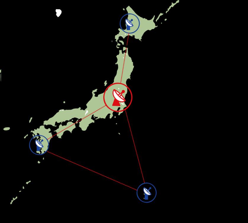
10 Location of Tsukuba & Kashima Mw km 308km TSUKUBA, GSI KASHIMA, NICT 10
11 Location of Tsukuba & Kashima Mw μSv/h TSUKUBA, GSI 168km 166km 0.129μSv/h KASHIMA, NICT 11


12 Damages around Tsukuba JMA seismic intensity scale: lower 6 (3 rd -highest level of 0-7 scale) Electricity: 2 day s blackout Water: 3 day s water supply interrupted Shopping center near my home Gymnasium of my son s primary school; the wall fell down Closed road due to cracks near my home 12


13 Tsukuba station and Correlator messy K-band receiver room Some of computers fell down from rack, and broke. 13


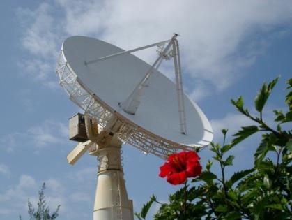
14 Tsukuba 32-m antenna after Earthquake The large elevation gear shaking from side to side. But miraculously, there is no critical damage in the antenna. Since we were afraid of damage due to large aftershocks, we postponed restarting of operation. Additionally we found broken electric relay for Az drive controller (not due to the earthquake). 2 weeks to replace. Broken relay 14


15 Serious damages around Kashima above left: Tsunami 2.6 km away from NICT above right: twisted railway 0.45 km away from NICT right: badly cracked road near NICT The detail was reported on poster (Ichikawa, R.) 15

16 GEONET: GPS-based control stations 5m 1,240 stations Distance km apart 16

17 GEONET: GPS-based control stations 1,240 stations km apart 17
18 Co-seismic displacement detected by GEONET Horizontal 5 hours after the main shock Choshi 40cm Hachinohe 54cm Souma 270cm Oshika 530cm Kashima (NICT) 68cm co-seismic horizontal displacement for 5 hours after the main shock main shock, some aftershocks and post-seismic displacement within 5-hr is included. Max. displacement is Oshika, 5.3m which is largest displacement ever. The direction of the displacement is southeast in Tohoku and east in Kanto. 18
19 Co-seismic displacement detected by GEONET Vertical 5 hours after the main shock Oshika -120cm co-seismic vertical displacement for 5 hours after the main shock main shock, some aftershocks and post-seismic displacement within 5-hr is included. Almost all points were subsided. Max. subsidence is Oshika, -1.2m. Souma -32cm Kashima -27cm Choshi -15cm 19

20 Post-seismic displacement detected by GEONET Horizontal 3/11~3/19 3/11~4/17 Yamada 25cm Yamada 44cm Mar. 12 M6.6 Apr. 11 M7.0 Choshi 17cm 20
21 Restarted IVS Observation MARCH APRIL, 2011 SUN MON TUE WED THU FRI SAT R1473 INT INT days after the earthquake R R1476 R1474 T2075 RD R1477 RDV86 R1474 R1473 canceled observed R1478 JD1104 RD1103 Intensive was restarted on May 7 21
22 VLBI positions before and after the earthquake TSUKUBA 32-m UEN wrt ITRF Earthquake 65cm East 2cm North Only IVS-R1 plotted 7cm Down 22

23 VLBI positions before and after the earthquake TSUKUBA 32-m UEN wrt ITRF months 16cm East 3.11 Earthquake 65cm East Only IVS-R1 plotted 2cm North 7cm Down 23

24 VLBI positions after the earthquake KASHIMA 11-m UEN wrt ITRF cm East 3.11 Earthquake 12cm Down 13cm South 24
 Publishing survey results(lat., lon.")


25 Survey results of control points Infrastructure for administration of country Maintaining control points(geonet, triangulation points, benchmarks) Publishing survey results(lat., lon., height) for public survey of local government Survey Act, Article 31 (revision of survey result) GPS Triangulation point Benchmark The Director-General of shall revise the survey result without delay, in the case where the survey result of basic survey is not in conformity with the current status due to the change of the geosphere, the topography or the feature, or other reasons. GSI is responsible for revising coordinates of control points immediately in case where the position was changed. 25

26 Interrupt publishing survey results of control points Area the distortion becomes over 2 ppm the crustal displacement was widespread and its magnitude was very large. GSI determined the revision area where the distortion becomes over 2 ppm. the area covered the eastern half of Japan; 20 prefectures. GSI interrupted to publish the survey result immediately after March
 - A priori source: ICRF2 - Strong constraint NNT/NNR except TSUKUB32 - independent solution of")
27 VLBI position as practical origin of control points IVS R1482 on May 9-10 VLBI position TSUKUB32 epoch: May 10, 04:58:26 X= m Y= m Z= m Analysis strategy: - A priori station: ITRF2008 (pos & vel) - A priori source: ICRF2 - Strong constraint NNT/NNR except TSUKUB32 - independent solution of Calc/Solve 27
 TSKB IGS station epoch May 10 Add postseismic displacement for 2 weeks detected by GEONET")

28 Procedure for calculating coordinates of control points Colocation vector from VLBI to TSKB ( ΔX, ΔY, ΔZ ) TSKB IGS station epoch May 10 Add postseismic displacement for 2 weeks detected by GEONET X, Y, Z, epoch May 10 TSKB IGS station epoch May points of GEONET station coordinates were calculated by TSKB coordinate as given coordinate. First, the GEONET coord. were published on May

29 New survey result was published GPS-based control stations # of points 438 / 1,240 Triangulation points 43,857 / 109,074 1 st -order 353 / nd -order 2,140 / 5,060 3 rd -order 15,170 / 32,326 4 th -order 26,194 / 70,713 Benchmarks 1,379 / 18,239 Total: 45,674 / 128,553 (35.3%) published on October 31 About 2,000 of control points were resurveyed and others were calculated by adjustment parameter. 29
30 Summary The Tohoku mega earthquake and great tsunami caused by the earthquake inflicted enormous damage on eastern Japan. Even in Ibaraki prefecture where GSI and NICT are located, a lot of roads and buildings were damaged. GSI observed larger displacement than ever before by using space geodetic techniques, the results became wellknown throughout the world. Furthermore, the post-earthquake position of Tsukuba VLBI station became the practical origin of revised control points which is 35 % of whole control points in Japan. Even now, just one year later, post-seismic displacement has lasted and an aftershock occurs at least a few times a week even in Tsukuba. 30
31 Summary The Tohoku mega earthquake and great tsunami caused by the earthquake inflicted enormous damage on eastern Japan. Even in Ibaraki prefecture where GSI and NICT are located, a lot of roads and buildings were damaged. GSI observed larger displacement than ever before by using space geodetic techniques, the results became wellknown throughout the world. Furthermore, the post-earthquake position of Tsukuba VLBI station became the practical origin of revised control points which is 35 % of whole control points in Japan. Even now, just one year later, post-seismic displacement has lasted and an aftershock occurs at least a few times a week even in Tsukuba. The greatest impact for us is that the budget for VLBI2010 was approved as a budget for disaster, due to the Tohoku earthquake. 31
32 Thank you for your attention. 32
Seismic Activity and Crustal Deformation after the 2011 Off the Pacific Coast of Tohoku Earthquake
 J-RAPID Symposium March 6-7, 2013 Seismic Activity and Crustal Deformation after the 2011 Off the Pacific Coast of Tohoku Earthquake Y. Honkura Tokyo Institute of Technology Japan Science and Technology
Case study of Japan: Reference Frames in Practice
 Case study of Japan: Reference Frames in Practice Basara Miyahara and Koji Matsuo Sponsors: 1 Outline Introduction - Geodetic reference frame of Japan - GEONET : continuous GNSS observation system Geometric
How GNSS CORS in Japan works for geodetic control and disaster mitigations
 ICG Working Group D Reference Frames, Timing and Applications How GNSS CORS in Japan works for geodetic control and disaster mitigations ICG11, Nov. 7-11, 2016, Sochi, Russia Hiromichi TSUJI Geodetic Observation
Crustal deformation by the Southeast-off Kii Peninsula Earthquake
 Crustal deformation by the Southeast-off Kii Peninsula Earthquake 51 Crustal deformation by the Southeast-off Kii Peninsula Earthquake Tetsuro IMAKIIRE, Shinzaburo OZAWA, Hiroshi YARAI, Takuya NISHIMURA
Case Study of Japan: Crustal deformation monitoring with GNSS and InSAR
 Technical Seminar Reference Frame in Practice, Case Study of Japan: Crustal deformation monitoring with GNSS and InSAR Basara Miyahara miyahara-b96ip@milt.go.jp Geospatial Information Authority of Japan
THE 2011 TOHOKU EARTHQUAKE IN JAPAN. VSU Lyuben Karavelov, Sofia, Bulgaria. Key words: Tohoku earthquake, strong ground motion, damage
 THE 2011 TOHOKU EARTHQUAKE IN JAPAN Radan Ivanov 1 VSU Lyuben Karavelov, Sofia, Bulgaria Abstract: This earthquake which occurred on March 11, 2011, had a magnitude of 9.0, which places it as the fourth
Global Positioning System(GPS) Global Positioning System(GPS) is a new surveying technique applying space technology designed by the United States
 Global Positioning System(GPS) is a new surveying technique applying space technology designed by the United States") IV/317 Crustal deformations in the Japanese islands observed with the nationwide continuous GPS observation system Takashi TADA (Crustal Dynamics Department, Geographical Survey Institute, Tsukuba, Ibaraki,
IV/317 Crustal deformations in the Japanese islands observed with the nationwide continuous GPS observation system Takashi TADA (Crustal Dynamics Department, Geographical Survey Institute, Tsukuba, Ibaraki,
at IHO IRCC7 Mexico City, Mexico, June 2015
 Report on Japan s Response to Disasters presented by JHOD at IHO IRCC7 Mexico City, Mexico, 01 03 June 2015 JAPAN COAST GUARD Actions against huge earthquake Actions taken by JHOD against the Great East
NGIAs' roles in successful disaster response
 The Second UN-GGIM-AP Plenary Meeting NGIAs' roles in successful disaster response Japan Teheran Iran 28 October 2013 Shin-ichi SAKABE, Director of International Affairs Division Geospatial Information
Reconstruction of Geodetic Reference Frame after the 2011 off the Pacific Coast of Tohoku Earthquake
 Reconstruction of Geodetic Reference Frame after the 2011 off the Pacific Coast of Tohoku Earthquake Basara MIYAHARA, Takashi TOYOFUKU Tomoaki FURUYA, Yohei HIYAMA, Atsushi YAMAGIWA, Japan Key words: GNSS/GPS,
Earthquake Hazards. Tsunami
 Earthquake Hazards Tsunami Review: What is an earthquake? Earthquake is the vibration (shaking) and/or displacement of the ground produced by the sudden release of energy. The point inside the Earth where
REPORT ON THE TOHOKU AREA PASIFIC OFFSHORE EARTHQUAKE
 REPORT ON THE TOHOKU AREA PASIFIC OFFSHORE EARTHQUAKE GENERAL PERSPECTIVE The Highest Magnitude Ever Recorded The 2011 off the Pacific Coast of Tohoku Earthquake (hereafter, the 2011 Tohoku- Pacific Earthquake
Earthquake Hazards. Tsunami
 Earthquake Hazards Tsunami Measuring Earthquakes Two measurements that describe the power or strength of an earthquake are: Intensity a measure of the degree of earthquake shaking at a given locale based
Earthquake Hazards. Tsunami
 Earthquake Hazards Tsunami Review: What is an earthquake? Earthquake is the vibration (shaking) and/or displacement of the ground produced by the sudden release of energy. The point inside the Earth where
Title. Author(s)Heki, Kosuke. CitationScience, 332(6036): Issue Date Doc URL. Type. File Information. A Tale of Two Earthquakes
Heki, Kosuke. CitationScience, 332(6036): Issue Date Doc URL. Type. File Information. A Tale of Two Earthquakes") Title A Tale of Two Earthquakes Author(s)Heki, Kosuke CitationScience, 332(6036): 1390-1391 Issue Date 2011-06-17 Doc URL http://hdl.handle.net/2115/48524 Type article (author version) File Information
Title A Tale of Two Earthquakes Author(s)Heki, Kosuke CitationScience, 332(6036): 1390-1391 Issue Date 2011-06-17 Doc URL http://hdl.handle.net/2115/48524 Type article (author version) File Information
22 Bulletin of the Geospatial Information Authority of Japan, Vol.59 December, 2011 Fig. 1 Crustal deformation (horizontal) associated with the 2011 o
 associated with the 2011 o") The Crustal Deformation and Fault Model of the 2011 off the Pacific Coast of Tohoku Earthquake 21 The Crustal Deformation and Fault Model of the 2011 off the Pacific Coast of Tohoku Earthquake Tetsuro
The Crustal Deformation and Fault Model of the 2011 off the Pacific Coast of Tohoku Earthquake 21 The Crustal Deformation and Fault Model of the 2011 off the Pacific Coast of Tohoku Earthquake Tetsuro
Disclaimer. This report was compiled by an ADRC visiting researcher (VR) from ADRC member countries.
 from ADRC member countries.") Disclaimer This report was compiled by an ADRC visiting researcher (VR) from ADRC member countries. The views expressed in the report do not necessarily reflect the views of the ADRC. The boundaries and
Disclaimer This report was compiled by an ADRC visiting researcher (VR) from ADRC member countries. The views expressed in the report do not necessarily reflect the views of the ADRC. The boundaries and
Earthquake Source. Kazuki Koketsu. Special Session: Great East Japan (Tohoku) Earthquake. Earthquake Research Institute, University of Tokyo
 Earthquake. Earthquake Research Institute, University of Tokyo") 2012/9/24 17:20-17:35 WCEE SS24.4 Special Session: Great East Japan (Tohoku) Earthquake Earthquake Source Kazuki Koketsu Earthquake Research Institute, University of Tokyo 1 Names and features of the earthquake
2012/9/24 17:20-17:35 WCEE SS24.4 Special Session: Great East Japan (Tohoku) Earthquake Earthquake Source Kazuki Koketsu Earthquake Research Institute, University of Tokyo 1 Names and features of the earthquake
Report for 15th PCGIAP Meeting at 18th UNRCC-AP Working Group 1 Regional Geodesy
 Report for 15th PCGIAP Meeting at 18th UNRCC-AP Working Group 1 Regional Geodesy Chairman Shigeru Matsuzaka, Japan - shigeru@gsi.go.jp Vice Chairman Prof. Pengfei Cheng, China - chengpf@casm.ac.cn John
The March 11, 2011, Tohoku-oki earthquake (Japan): surface displacement and source modelling
: surface displacement and source modelling") The March 11, 2011, Tohoku-oki earthquake (Japan): surface displacement and source modelling Salvatore Stramondo Bignami C., Borgstrom S., Chini M., Guglielmino F., Melini D., Puglisi G., Siniscalchi V.,
The March 11, 2011, Tohoku-oki earthquake (Japan): surface displacement and source modelling Salvatore Stramondo Bignami C., Borgstrom S., Chini M., Guglielmino F., Melini D., Puglisi G., Siniscalchi V.,
Response characteristics of R/C buildings considering impulsive force of tsunami drifting objects
 Response characteristics of R/C buildings considering impulsive force of tsunami drifting objects Ho CHOI 1, Kazuto MATSUKAWA 2 and Yoshiaki NAKANO 3 1 Research Associate, Institute of Industrial Science,
History of International Training in Seismology and Earthquake Engineering at IISEE
 History of International Training in Seismology and Earthquake Engineering at IISEE Activities of International Institute of Seismology and Earthquake Engineering (IISEE), BRI - Training for young researchers/engineers
4-3-1 Earthquake and Tsunami Countermeasures of Tokyo s
 4-3-1 Earthquake and Tsunami Countermeasures of Tokyo s Sewerage Masahiro Hikino* and Gaku Sato** *Planning Section, Planning and Coordinating Division, Bureau of Sewerage, Tokyo Metropolitan Government
Earthquakes and Tsunamis
 Earthquakes and Tsunamis Kenji Satake Earthquake Research Institute University of Tokyo 1 Part I 2011 Tohoku earthquake and tsunami 2 Fukushima Dai ichi NPP accident Earthquake ground motion Reactors automatically
Basic Analysis on Building Damages by Tsunami due to The 2011 Great East Japan Earthquake Disaster Using GIS
 Basic Analysis on Building Damages by Tsunami due to The 2011 Great East Japan Earthquake Disaster Using GIS Kunihiro Amakuni Pacific Consultants Co. Ltd., Tokyo, Japan Naoto Terazono, Toshio Yamamoto&
 Title Preliminary report of the 2011 off Earthquake Author(s) Takewaki, Izuru Citation Journal of Zhejiang University SCIE 327-334 Issue Date 2011-05 URL http://hdl.handle.net/2433/159442 RightThe final
Study of the liquefaction phenomenon due to an earthquake: case study of Urayasu city
 Disaster Management and Human Health Risk III 311 Study of the liquefaction phenomenon due to an earthquake: case study of Urayasu city S. Kamao 1, M. Takezawa 1, K. Yamada 1, S. Jinno 1, T. Shinoda 1
Tsunami waves swept away houses and cars in northern Japan and pushed ships aground.
 Japan was struck by a magnitude 8.9 earthquake off its northeastern coast Friday. This is one of the largest earthquakes that Japan has ever experienced. In downtown Tokyo, large buildings shook violently
Magnitude 7.1 NEAR THE EAST COAST OF HONSHU, JAPAN
 Japan was rattled by a strong aftershock and tsunami warning Thursday night nearly a month after a devastating earthquake and tsunami flattened the northeastern coast. This earthquake can be considered
crustal structure experiment beneath Wairarapa - Wellington area: results from SAHKE
 crustal structure experiment beneath Wairarapa - Wellington area: results from SAHKE Tim Stern and SAHKE team* * VUW, GNS, University of Southern California, University of Tokyo(Japan) SAHKE = Seismic
Preliminary report of the 2011 off the Pacific coast of Tohoku Earthquake *
 Takewaki / J Zhejiang Univ-Sci A (Appl Phys & Eng) 211 12(5):327-334 327 Journal of Zhejiang University-SCIENCE A (Applied Physics & Engineering) ISSN 1673-565X (Print); ISSN 1862-1775 (Online) www.zju.edu.cn/jzus;
- Information before strong ground motion -
 -Earthquake Early Warning - Information before strong ground motion - Mitsuyuki HOSHIBA Japan Meteorological Agency January 12, 2007 1 Distribution of Earthquakes Causing Tsunami (1896~2004) in Japan Distribution
The Impact of the 2010 Darfield (Canterbury) Earthquake on the Geodetic Infrastructure in New Zealand 1
 Earthquake on the Geodetic Infrastructure in New Zealand 1") The Impact of the 2010 Darfield (Canterbury) Earthquake on the Geodetic Infrastructure in New Zealand 1 Graeme BLICK, John BEAVAN, Chris CROOK, Nic DONNELLY Keywords: Darfield Earthquake, control, survey,
The Impact of the 2010 Darfield (Canterbury) Earthquake on the Geodetic Infrastructure in New Zealand 1 Graeme BLICK, John BEAVAN, Chris CROOK, Nic DONNELLY Keywords: Darfield Earthquake, control, survey,
Warkworth geodetic station as a potential GGOS core site in New Zealand
 "Launching the Next-Generation IVS Network Session 2: Correlators, Stations and Operations Centers. 7th IVS General Meeting March 5, 2012 Madrid, Spain Warkworth geodetic station as a potential GGOS core
ESTIMATES OF HORIZONTAL DISPLACEMENTS ASSOCIATED WITH THE 1999 TAIWAN EARTHQUAKE
 ESTIMATES OF HORIZONTAL DISPLACEMENTS ASSOCIATED WITH THE 1999 TAIWAN EARTHQUAKE C. C. Chang Department of Surveying and Mapping Engineering Chung Cheng Institute of Technology, Taiwan, ROC ABSTRACT A
Prevention Tsunami wall 10m high (breached by the tsunami due to land level falling by 3m)
") Plate margin Plates Causes Sendai, Japan Convergent plate margin Pacific and Eurasian Plates Convergent plate margin Sima (Pacific plate) moves towards the sial (Eurasian plate) Sima (Pacific plate) is
Plate margin Plates Causes Sendai, Japan Convergent plate margin Pacific and Eurasian Plates Convergent plate margin Sima (Pacific plate) moves towards the sial (Eurasian plate) Sima (Pacific plate) is
Department of Civil Engineering, Kyoto University, by Shunzo OKAMOTO, M. J. A., Sept.
 214 Proc. Japan Acad., 71, Ser. B (1995) [Vol. 71(B), Extremely High Damage Potential Comparison of the Hyogo-ken of Near Field Earthquake Ground Nanbu and the Northridge Earthquakes Motion By Hirokazu
We have previously looked at artificial seismograms such as this one here.
 We have previously looked at artificial seismograms such as this one here. S P A realistic Seismic Record Each vertical line = 1 minute Each horizontal line = 15 minutes Seismic station PMM is in Parkfield,
Three Fs of earthquakes: forces, faults, and friction. Slow accumulation and rapid release of elastic energy.
 Earthquake Machine Stick-slip: Elastic Rebound Theory Jerky motions on faults produce EQs Three Fs of earthquakes: forces, faults, and friction. Slow accumulation and rapid release of elastic energy. Three
Lessons Learned from Past Tsunamis Warning and Emergency Response
 UNESCO IOC CTIC US NOAA ITIC Regional Training Workshop on Strengthening Tsunami Warning and Emergency Response Standard Operating Procedures and the Development of the ICG/CARIBE-EWS PTWC New Enhanced
Scaling relations of seismic moment, rupture area, average slip, and asperity size for M~9 subduction-zone earthquakes
 GEOPHYSICAL RESEARCH LETTERS, VOL. 4, 7 74, doi:1.12/grl.976, 213 Scaling relations of seismic moment, rupture area, average slip, and asperity size for M~9 subduction-zone earthquakes Satoko Murotani,
The Earthquake of Padang, Sumatra of 30 September 2009 scientific information and update
 The Earthquake of Padang, Sumatra of 30 September 2009 scientific information and update 01-October-2009 Christophe Vigny Directeur de recherches at CNRS Laboratoire de Géologie Geoscience Dept. Of ENS,
KNOWLEDGE NOTE 5-1. Risk Assessment and Hazard Mapping. CLUSTER 5: Hazard and Risk Information and Decision Making. Public Disclosure Authorized
 Public Disclosure Authorized Public Disclosure Authorized Public Disclosure Authorized Public Disclosure Authorized KNOWLEDGE NOTE 5-1 CLUSTER 5: Hazard and Risk Information and Decision Making Risk Assessment
2 nd IRF Asia Regional Congress & Exhibition October 16-20, 2016 Kuala Lumpur, Malaysia
 2 nd IRF Asia Regional Congress & Exhibition October 16-20, 2016 Kuala Lumpur, Malaysia PAPER TITLE Preliminary report for IRI changes after KUMAMOTO earthquake Japan, by using Smartphone roughness measurement
Outline of the 2011 off the Pacific coast of Tohoku Earthquake (M w 9.0) Earthquake Early Warning and observed seismic intensity
 Earthquake Early Warning and observed seismic intensity") LETTER Earth Planets Space, 63, 547 551, 2011 Outline of the 2011 off the Pacific coast of Tohoku Earthquake (M w 9.0) Earthquake Early Warning and observed seismic intensity Mitsuyuki Hoshiba 1, Kazuhiro
LETTER Earth Planets Space, 63, 547 551, 2011 Outline of the 2011 off the Pacific coast of Tohoku Earthquake (M w 9.0) Earthquake Early Warning and observed seismic intensity Mitsuyuki Hoshiba 1, Kazuhiro
Tsunami Risk Mitigation Strategy for Thailand. Kjell Karlsrud Norwegian Geotechnical Institute (NGI)
") Tsunami Risk Mitigation Strategy for Thailand Kjell Karlsrud Norwegian Geotechnical Institute (NGI) The project was undertaken by NGI in cooperation with: NORSAR, UiB, UiO, NIBR, B.Heyerdahl, NTNU, Sintef
Tsunami Risk Mitigation Strategy for Thailand Kjell Karlsrud Norwegian Geotechnical Institute (NGI) The project was undertaken by NGI in cooperation with: NORSAR, UiB, UiO, NIBR, B.Heyerdahl, NTNU, Sintef
ACTIVITIES OF THE HEADQUARTERS FOR EARTHQUAKE RESEARCH PROMOTION
 Journal of Japan Association for Earthquake Engineering, Vol.4, No.3 (Special Issue), 2004 ACTIVITIES OF THE HEADQUARTERS FOR EARTHQUAKE RESEARCH PROMOTION Sadanori HIGASHI 1 1 Member of JAEE, Earthquake
2.3 Notes: Earthquake Damage Can Be Reduced
 2.3 Notes: Earthquake Damage Can Be Reduced Earthquakes can cause severe damage and loss of life Each year, there is about one earthquake with a magnitude of or higher-this is an extremely earthquake.
Sendai Earthquake NE Japan March 11, Some explanatory slides Bob Stern, Dave Scholl, others updated March
 Sendai Earthquake NE Japan March 11, 2011 Some explanatory slides Bob Stern, Dave Scholl, others updated March 14 2011 Earth has 11 large plates and many more smaller ones. Plates are 100-200 km thick
Deformation cycles of great subduction earthquakes in a viscoelastic Earth
 Deformation cycles of great subduction earthquakes in a viscoelastic Earth Kelin Wang Pacific Geoscience Centre, Geological Survey of Canada School of Earth and Ocean Science, University of Victoria????
S. Toda, S. Okada, D. Ishimura, and Y. Niwa International Research Institute of Disaster Science, Tohoku University, Japan
 The first surface-rupturing earthquake in 20 years on a HERP major active fault: Mw=6.2 2014 Nagano, Japan, event along the Itoigawa-Shizuoka Tectonic Line is not characteristic S. Toda, S. Okada, D. Ishimura,
3.3 Analysis Coordinator
 1. Introduction 2. Analysis of ITRF2014 post-seismic parameterization In this report we outline the activities of the Analysis Coordinator during 2015. The main activities were analysis of the ITRF2014
Japan Quake: Why Do Humans Live In Dangerous Places? By Simon Saint
 Japan Quake: Why Do Humans Live In Dangerous Places? By Simon Saint What are some good things that volcanoes do? - Mount Saint Helens; Japan Earthquakes and Volcanoes; Eruptions; Rocks of the countries
Earthquakes and Earth s Interior
 - What are Earthquakes? Earthquakes and Earth s Interior - The shaking or trembling caused by the sudden release of energy - Usually associated with faulting or breaking of rocks - Continuing adjustment
12/07/2013. Apparent sea level rise and earthquakes
 Main collaborations: - P. Simeoni - M. N. Bouin - S. Calmant Valérie Ballu Valerie.ballu@univ-lr.fr Apparent sea level rise and earthquakes possibly the world s first community to be formally moved out
Annual Report for Research Work in the fiscal year 2005
 JST Basic Research Programs C R E S T (Core Research for Evolutional Science and Technology) Annual Report for Research Work in the fiscal year 2005 Research Area : High Performance Computing for Multi-scale
Coseismic slip model
 Figure 3 - Preliminary highly smoothed model of coseismic slip for the 11 March UCL Institute for Risk & Disaster Reduction Magnitude 9.0 (JMA scale) earthquake Occurred at 02:46:23 pm local time near
The great earthquakes that have shaped Japan 日本に大きな影響を与えた地震
 The great earthquakes that have shaped Japan 日本に大きな影響を与えた地震 Brian Kennett, Research School of Earth Sciences, ANU Takashi Furumura Earthquake Research Institute, University of Tokyo Japan tectonic plates
The Tohoku Earthquake 2011 Case.
 Wide Area Deformation map generation with TerraSAR-X Data. The Tohoku Earthquake 2011 Case. N. Yague-Martinez (1), C. Minet (2), M. Eineder (2), B. Schättler (2) (1) Starlab, Spain (2) Remote Sensing Technology
Tohoku-oki event: Tectonic setting
 Tohoku-oki event: Tectonic setting This earthquake was the result of thrust faulting along or near the convergent plate boundary where the Pacific Plate subducts beneath Japan. This map also shows the
Source region of the earthquake
 Disasters of port facilities due to 2011 Great East Japan Earthquake Yoshiaki Kikuchi Port & Airport Research Institute Contents Outline of the earthquake Measured Tsunami height Breakwater disasters by
Earthquakes. Written by: Lillie Hamstick
 Earthquakes Written by: Lillie Hamstick Table of Contents Meeting an Earthquake. 1 Dangerous Destruction.. 2 Exciting Earthquakes 3 Yo, What Causes an Earthquake... 4 Where Are You Earthquake. 5 How to
Lessons from the 2004 Sumatra earthquake and the Asian tsunami
 Lessons from the 2004 Sumatra earthquake and the Asian tsunami Kenji Satake National Institute of Advanced Industrial Science and Technology Outline 1. The largest earthquake in the last 40 years 2. Tsunami
Tohoku Earthquake and Tsunami Japan March 11, 2011 Information updated 4/19/2011
 Tohoku Earthquake and Tsunami Japan March 11, 2011 Information updated 4/19/2011 On March 11, 2011 a massive earthquake occurred on the ocean floor south of the northeastern Tohoku region of the Japanese
Revival from Earthquake Disaster and Asbestos Problems
 Journal of Policy Science Vol.6 Revival from Earthquake Disaster and Asbestos Problems ISHIHARA Kazuhiko 1. Introduction Asbestos are used mostly in building materials, for instance sprayed asbestos, cement
Making the Original Earthquake Early Warning System including epicentral earthquake
 Making the Original Earthquake Early Warning System including epicentral earthquake Protecting your life and minimizing damage. TEL: 0742-53-7833 4F, Oshikuma-cho 557-7, Nara-City 631-0011, Japan URL http://www.jjjnet.com
Seismic vulnerability in Latinamerica Speaker: Rafael Osiris de León Sciences Academy of Dominican Republic.
 Seismic vulnerability in Latinamerica Speaker: Rafael Osiris de León Sciences Academy of Dominican Republic. IANAS GENERAL ASSEMBLY Punta Cana, 16-20 July, 2013 TECTONIC PLATES AND EARTHQUAKES Pacific
Widespread Ground Motion Distribution Caused by Rupture Directivity during the 2015 Gorkha, Nepal Earthquake
 Widespread Ground Motion Distribution Caused by Rupture Directivity during the 2015 Gorkha, Nepal Earthquake Kazuki Koketsu 1, Hiroe Miyake 2, Srinagesh Davuluri 3 and Soma Nath Sapkota 4 1. Corresponding
Tsukuba, Japan International Institute of Seismology and Earthquake Engineering Building Research Institute STUDY TRIP TO ITAKO CITY
 Tsukuba, Japan International Institute of Seismology and Earthquake Engineering Building Research Institute STUDY TRIP TO ITAKO CITY A Technical Report By MARTINEZ BRAVO Delvin Abdiel (MEE10515) Disaster
Special feature: Are its lessons being adequately applied? Follow-up on the ten-year anniversary of the Hanshin-Awaji Earthquake
 Special feature: Are its lessons being adequately applied? Follow-up on the ten-year anniversary of the Hanshin-Awaji Earthquake - Are we prepared for future massive earthquakes? - Hisakazu SAKAI Member
JMA Tsunami Warning Services. Tomoaki OZAKI Senior Coordinator for Tsunami Forecast Modeling Japan Meteorological Agency
 JMA Tsunami Warning Services Tomoaki OZAKI Senior Coordinator for Tsunami Forecast Modeling Japan Meteorological Agency Organization Chart of the Government of Japan Cabinet Office Diet Ministry of Internal
SEISMIC HAZARD ASSESSMENT FOR JAPAN AFTER THE 2011 TOHOKU-OKI MEGA-THRUST EARTHQUAKE (Mw9.0)
") Proceedings of the International Symposium on Engineering Lessons Learned from the 2011 Great East Japan Earthquake, March 1-4, 2012, Tokyo, Japan SEISMIC HAZARD ASSESSMENT FOR JAPAN AFTER THE 2011 TOHOKU-OKI
Proceedings of the International Symposium on Engineering Lessons Learned from the 2011 Great East Japan Earthquake, March 1-4, 2012, Tokyo, Japan SEISMIC HAZARD ASSESSMENT FOR JAPAN AFTER THE 2011 TOHOKU-OKI
Estimation of Damage Ratios of Wooden Houses and Water Distribution Pipelines in an Earthquake Scenario for the Tokyo Metropolitan Region
 The 2011 World Congress on Advances in Structural Engineering and Mechanics (ASEM'11 + ) Seoul, Korea, 18-22 September, 2011 Estimation of Damage Ratios of Wooden Houses and Water Distribution Pipelines
Low-Latency Earthquake Displacement Fields for Tsunami Early Warning and Rapid Response Support
 Low-Latency Earthquake Displacement Fields for Tsunami Early Warning and Rapid Response Support Hans-Peter Plag, Geoffrey Blewitt Nevada Bureau of Mines and Geology and Seismological Laboratory University
Earthquakes Science & Safety. Ms Joan L. Latchman Seismologist Seismic Research Unit
 Earthquakes Science & Safety Ms Joan L. Latchman Seismologist Seismic Research Unit Summary Trinidad lies in an area of high earthquake activity for the Caribbean. Earthquake safety tips should be practiced
JP experience of earthquake, tsunami, and nuclear plant accident
 JP experience of earthquake, tsunami, and nuclear plant accident ccnso Members Meeting 21 June 2011 Hiro Hotta What happened (1) Earthquake Friday, March 11, 2011 14:46 JST Earthquake
GEO-VIII November Geohazard Supersites and Natural Laboratories Progress Report. Document 9
 GEO-VIII 16-17 November 2011 Geohazard Supersites and Natural Laboratories Progress Report Document 9 This document is submitted to GEO-VIII for information. Geohazard Supersites and Natural Laboratories
EXTRACTION OF FLOODED AREAS DUE THE 2015 KANTO-TOHOKU HEAVY RAINFALL IN JAPAN USING PALSAR-2 IMAGES
 EXTRACTION OF FLOODED AREAS DUE THE 2015 KANTO-TOHOKU HEAVY RAINFALL IN JAPAN USING PALSAR-2 IMAGES F. Yamazaki a, *, W. Liu a a Chiba University, Graduate School of Engineering, Chiba 263-8522, Japan
The Mega-Earthquakes of Chile: Seismology and the Sounds of the Earth
 The Mega-Earthquakes of Chile: Seismology and the Sounds of the Earth Michael Wysession Department of Earth and Planetary Sciences Washington University, St. Louis, MO Puerto Montt, Chile, November 6,
Strong ground motions from the 2011 off-the Pacific-Coast-of-Tohoku, Japan (Mw=9.0) earthquake obtained from a dense nationwide seismic network
 earthquake obtained from a dense nationwide seismic network") Landslides (2011) 8:333 338 DOI 10.1007/s10346-011-0279-3 Received: 10 June 2011 Accepted: 5 July 2011 Published online: 23 July 2011 The Author(s) 2011. This article is published with open access at Springerlink.com
Landslides (2011) 8:333 338 DOI 10.1007/s10346-011-0279-3 Received: 10 June 2011 Accepted: 5 July 2011 Published online: 23 July 2011 The Author(s) 2011. This article is published with open access at Springerlink.com
Running Head: JAPANESE TSUNAMI 1. Geological Perspective of the Japanese Tsunami
 Running Head: JAPANESE TSUNAMI 1 Geological Perspective of the Japanese Tsunami JAPANESE TSUNAMI 2 JAPANESE TSUNAMI 3 Abstract Humanity is characterized with flaws, so is planet earth. Earthquakes shake
Occurrence of quasi-periodic slow-slip off the east coast of the Boso peninsula, Central Japan
 LETTER Earth Planets Space, 9, 11 1, Occurrence of quasi-periodic slow-slip off the east coast of the Boso peninsula, Central Japan Shinzaburo Ozawa, Hisashi Suito, and Mikio Tobita Geographical Survey
Recent Progress of Seismic Observation Networks in Japan
 Journal of Physics: Conference Series Recent Progress of Seismic Observation Networks in Japan To cite this article: Y Okada 2013 J. Phys.: Conf. Ser. 433 012039 Related content - Physical applications
Earthquakes & Volcanoes
 Earthquakes & Volcanoes Geology - the study of solid Earth, the rocks of which it is composed, and the processes by which they change geo = Earth; ology = study of Earth s Layers Plate Tectonics - the
Hazard and Vulnerability of Moderate Seismicity Regions
 Hazard and Vulnerability of Moderate Seismicity Regions presented by Professor Tso-Chien PAN Dean, College of Engineering Director, 25 October 2010 DRM GDLN Session on Earthquake Vulnerability Reduction
Natural Disasters. Why Are There Earthquakes? 197 words. The Power of the Earth 221 words. Big Waves! 188 words
 ARTICLE-A-DAY Natural Disasters 6 Articles Check articles you have read: Why Are There Earthquakes? 197 words The Power of the Earth 221 words Big Waves! 188 words The Volcano That Keeps Erupting 228 words
Not all eruptions are the same. Sometimes, there is a huge explosion. The hot magma shoots
 Natural Disasters A natural disaster is an event that happens in nature. It is an event that can cause a lot of damage. Volcanoes, earthquakes, and tsunamis are all natural disasters. Volcanoes A volcano
UNIVERSITY GADJAH MADA EUBIOS YOUTH LOOKING BEYOND DISASTER (LBD5) FORUM 4-8 SEPTEMBER, Hosted by: Universitas Gadjah Mada
 FORUM 4-8 SEPTEMBER, Hosted by: Universitas Gadjah Mada") UNIVERSITY GADJAH MADA EUBIOS YOUTH LOOKING BEYOND DISASTER (LBD5) FORUM 4-8 SEPTEMBER, 2014 Hosted by: Universitas Gadjah Mada Outline LBD program Brief Information of Universitas Gadjah Mada, Indonesia
UNIVERSITY GADJAH MADA EUBIOS YOUTH LOOKING BEYOND DISASTER (LBD5) FORUM 4-8 SEPTEMBER, 2014 Hosted by: Universitas Gadjah Mada Outline LBD program Brief Information of Universitas Gadjah Mada, Indonesia
The Japanese University Joint Seismic Observations at the Niigaka-Kobe Tectonic Zone
 Bull. Earthq. Res. Inst. Univ. Tokyo Vol. 2*,**/ pp. +-- +.1 * The Japanese University Joint Seismic Observations at the Niigaka-Kobe Tectonic Zone The Japanese University Group of the Joint Seismic Observations
The map below shows the locations of earthquakes and volcanoes
 45 Understanding Plate Boundaries R E A D I N G The map below shows the locations of earthquakes and volcanoes on the earth s surface. Today, many of the world s most active volcanoes are located around
Magnitude 6.3 SOUTH ISLAND OF NEW ZEALAND
 A magnitude 6.3 earthquake shook the southern New Zealand city of Christchurch. At least 100 people are reported dead, and there are reports of collapsed buildings, cracked streets and flooding due to
Earthquakes. Earthquake Magnitudes 10/1/2013. Environmental Geology Chapter 8 Earthquakes and Related Phenomena
 Environmental Geology Chapter 8 Earthquakes and Related Phenomena Fall 2013 Northridge 1994 Kobe 1995 Mexico City 1985 China 2008 Earthquakes Earthquake Magnitudes Earthquake Magnitudes Richter Magnitude
New Tsunami Disaster Mitigation System considering Local Conditions of Indian Ocean Rim Regions
 New Tsunami Disaster Mitigation System considering Local Conditions of Indian Ocean Rim Regions Kimiro Meguro Professor, Institute of Industrial Science, The University of Tokyo, Japan Shunichi Koshimura
RELATIONSHIP BETWEEN AGE OF GROUND AND LIQUEFACTION OCCURRENCE IN THE 2011 GREAT EAST JAPAN EARTHQUAKE
 Proceedings of the International Symposium on Engineering Lessons Learned from the 2011 Great East Japan Earthquake, March 1-4, 2012, Tokyo, Japan RELATIONSHIP BETWEEN AGE OF GROUND AND LIQUEFACTION OCCURRENCE
Preparing for Major Earthquakes
 Preparing for Major Earthquakes Norimichi Kumagai Introduction To assure reliable transport railway operators must always be prepared for natural disasters. The Great East Japan Earthquake on 11 March
Correlating Radioactive Material to Sea Surface Temperature off the Coast of Japan: The Fukushima Daiichi Nuclear Disaster. Maya R.
 Correlating Radioactive Material to Sea Surface Temperature off the Coast of Japan: The Fukushima Daiichi Nuclear Disaster Maya R. Pincus Department of Geology, University of Puerto Rico-Mayagüez e-mail:
Abdul Muhari 1, Fumihiko Imamura 2, Taro Arikawa 3, and Bagus Afriyanto 1. Date; 15 October 2018
 Finding of the unexpected tsunami due to the strike-slip fault at central Sulawesi, Indonesia on 28 September 2018, from the preliminary field survey at Palu Abdul Muhari 1, Fumihiko Imamura 2, Taro Arikawa
Real Time Monitoring System for Megathrust Earthquakes and Tsunamis - Cabled Network System and Buoy System in Japan -
 Real Time Monitoring System for Megathrust Earthquakes and Tsunamis - Cabled Network System and Buoy System in Japan - 1 Subduction zones around the world Haiti Italy Turkey Tohoku Sichuan Taiwan Sumatra
Earthquakes and Tsunamis
 Earthquakes and Tsunamis Disaster prevention and mitigation efforts Japan Meteorological Agency Introduction Introduction Japan an earthquake-prone country Earthquake/Tsunami Monitoring and Flow of Warnings/Information
Risk-based land use and spatial planning
 Risk-based land use and spatial planning Miho OHARA International Centre for Water Hazards and Risk Management (ICHARM) Public Works Research Institute PWRI), Japan Under the auspices of UNESCO Introduction