Tsunami. Harry Yeh Oregon State University. Eastern Japan Earthquake Disaster Briefing at PEER: April 28, 2011
|
|
|
- Dulcie Collins
- 6 years ago
- Views:
Transcription


1 Tsunami by Harry Yeh Oregon State University Eastern Japan Earthquake Disaster Briefing at PEER: April 28, 2011
2 Seismic Characteristics Rupture Model (Harvard Seismology) The fault rupture process was complex, and the extent of the rupture was approximately 480 km by 170 km. (The 2004 Great Indian Ocean Tsunami: 1300 km by 160 km.)
3 Historical Tsunamis in Sanriku Coasts The 869 Jougan Sanriku Tsunami M8.3 ~ 8.6. The 1611 Keichou Sanriku Tsunami M 8.1 Maximu tsunami runup height 15 ~ 20 m. The 1896 Meiji Sanriku Tsunami M 7.2 (Mw 8.2 ~ 8.5) Maximum tsunami runup height 38.2 m The 1933 Showa Sanriku Tsunami (Mw 8.4) Maximum tsunami runup height 28.7 m The 2011 Tohoku Tsunami (Mw 9.0) Maximum tsunami runup height 38 m The 1896 Meiji Tsunami The 1933 Showa Tsunami The 2011 Tohoku Tsunami
 Maximum tsunami runup height 38.2 m The 1933 Showa Sanriku Tsunami (Mw 8.4) Maximum tsunami runup height 28.7 m The 2011 Tohoku Tsunami (Mw 9.")
4 Historical Tsunamis in Sanriku Coasts The 869 Jougan Sanriku Tsunami M8.3 ~ 8.6. The 1611 Keichou Sanriku Tsunami M 8.1 Maximu tsunami runup height 15 ~ 20 m. The 1896 Meiji Sanriku Tsunami M 7.2 (Mw 8.2 ~ 8.5) Maximum tsunami runup height 38.2 m The 1933 Showa Sanriku Tsunami (Mw 8.4) Maximum tsunami runup height 28.7 m The 2011 Tohoku Tsunami (Mw 9.0) Maximum tsunami runup height 38 m The fault rupture area is much greater than the previous cases. The 1896 Meiji Tsunami The 1933 Showa Tsunami The 2011 Tohoku Tsunami


5 GPS Wave Gage: 20 km off Kamaishi Water depth 204 m 55 cm land subsidence 6.7 m
6 Bathymetry 100 m 200 m 1000 m 100 m 200 m 1000 m 50 m 100 m 200 m 50 m 1000 m 20 km
7 50 m Bathymetry 50 m Shallow and wide continental shelf 100 m 100 m 100 m 200 m 200 m 200 m Steep and narrow continental shelf 1000 m 1000 m 1000 m


8 Arahama ( N E)
9 Arahama ( N E)
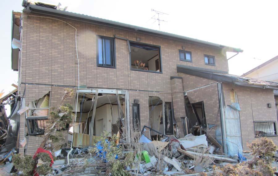
10 Arahama Why did this house survive? ( N E)


11 A large bus Yuriage ( N E)


12 Yuriage Large scour hole 7.5m x 15.0m x 1.2m deep Tsunami induced momentary liquefaction? ( N E)
13 Rikuzen Takada ( N E)

14 Rikuzen Takada Strong currents along Kesen River, scouring the railroad bank. Approximately 4 km upstream from the river mouth. Max. Runup = 18.5 m ( N E)


15 Rikuzen Takada before the Tsunami Tsunami forest and seawall along the shore before the tsunami attack ( N E)


16 Rikuzen Takada Scenes after March 11 tsunami -- no forest, no seawall, remain. Scenes after March 11 tsunami cm subsidence. ( N E)
17 Rikuzen Takada Inundation level Front and back windows of every unit were broken away except the top floor. Front Unit ( N E) Inundation elevation near the shore was about 14 ~ 15 m. Flooded 90cm above the floor on the top floor


18 Rikuzen Takada 1st Unit ( N E) Flooded 90cm above the floor on the top floor 2nd Unit

19 17.6 m Runup Onagawa 120 cm land subsidence. Inundation level Tsunami inundation was higher than the top of the concrete cliff. ( N E)
20

")
21 ( N E)
22 Onagawa The effective net weight of the building under total submergence is approximately 1,600 KN (estimated by Greg Deierlein). The fluid force can be estimated by F = 1 2 C d! A u2 where C d 2 for a square column. Take the moment balance at 0 finds the flow speed: u 2.5 m/sec ( N E)

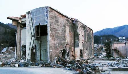
23 Onagawa Moment failure of the RC Building -- This is a new finding! This building can be toppled by rotation when the flow velocity exceeds 2.5 m/sec: this likely happened. ( N E)
24 Onagawa Onagawa NPP


25 Onagawa Success story? Onagawa NPP
26 Consideration on Tsunami Runups
27 Tsunami Runup Heights and Inundation Heights
28 Tsunami Runup Heights and Inundation Heights 10 m 20 m 30 m

29 50 m Bathymetry 50 m Shallow and wide continental shelf 100 m 100 m 100 m 200 m 200 m 200 m Steep and narrow continental shelf 1000 m 1000 m 1000 m
30 Tsunami Runup Heights and Inundation Heights The runup height of 10 m with the inundation distance more than 5 km into the very flat coastal plain indicate that the tsunami must had a very long wavelength. 10 m 20 m 30 m
31 Tsunami Runup Heights and Inundation Heights Very large tsunami runup heights (up to 38 m) in the northern Sanriku areas are still comparable with the effects of the 1896 Meiji Tsunami. 10 m 20 m 30 m
32 Tsunami Runup Heights and Inundation Heights The southern region of Sanriku had not been struck by local tsunamis; hence some of the engineered protections were designed based on the 1960 Chile Tsunami (runup 5 ~ 6 m). 10 m 20 m 30 m
33 Tsunami Runup Heights and Inundation Heights? and why? 10 m 20 m 30 m

34 Tsunami Runup Heights and Inundation Heights Very large minimum runup heights are noteworthy. 10 m 20 m 30 m
35 Summary Lots of things to learn from this natural disaster. especially for the future Cascadia event.
36 Tsunami Heights and the Heights of Seawalls
Features of Tsunami height according to type of coastal landforms 2011 Tohoku oki tsunami case
 Features of Tsunami height according to type of coastal landforms 2011 Tohoku oki tsunami case (70 Nobuhisa Matta (Disaster Mitigation Research Center Nagoya Univ.) July 3 rd, 2013, at Taipei Outline +
Earthquakes and Tsunamis
 Earthquakes and Tsunamis Kenji Satake Earthquake Research Institute University of Tokyo 1 Part I 2011 Tohoku earthquake and tsunami 2 Fukushima Dai ichi NPP accident Earthquake ground motion Reactors automatically
The Restoration Process from the Great East Japan Earthquake, and Perspectives for the Sustainable Society by Creating Cultural Landscapes
 Session 3 Restoration from the Huge Natural Disasters, and Creating Cultural Landscapes for the Sustainable Society The Restoration Process from the Great East Japan Earthquake, and Perspectives for the
Three Fs of earthquakes: forces, faults, and friction. Slow accumulation and rapid release of elastic energy.
 Earthquake Machine Stick-slip: Elastic Rebound Theory Jerky motions on faults produce EQs Three Fs of earthquakes: forces, faults, and friction. Slow accumulation and rapid release of elastic energy. Three
REPORT ON THE TOHOKU AREA PASIFIC OFFSHORE EARTHQUAKE
 REPORT ON THE TOHOKU AREA PASIFIC OFFSHORE EARTHQUAKE GENERAL PERSPECTIVE The Highest Magnitude Ever Recorded The 2011 off the Pacific Coast of Tohoku Earthquake (hereafter, the 2011 Tohoku- Pacific Earthquake
Mechanism of tsunami generation,propagation and runup -sharing experiences with Japanese
 Mechanism of tsunami generation,propagation and runup -sharing experiences with Japanese Mechanism of tsunami generation Predicting the propagation, runup and inundation of tsunamis Near and far-field
Source region of the earthquake
 Disasters of port facilities due to 2011 Great East Japan Earthquake Yoshiaki Kikuchi Port & Airport Research Institute Contents Outline of the earthquake Measured Tsunami height Breakwater disasters by
Tsunami potential and modeling
 Tsunami potential and modeling GEORGE PRIEST OREGON DEPT. OF GEOLOGY AND MINERAL INDUSTRIES NEWPORT COASTAL FIELD OFFICE April 7, 2012 GeoPRISMS Cascadia Workshop, Portland, Oregon What creates most uncertainty
The EEFIT Mission to Japan after the M W 9.0 Tōhoku Earthquake: Key Findings and Lessons Learned
 The EEFIT Mission to Japan after the M W 9.0 Tōhoku Earthquake: Key Findings and Lessons Learned By A. Pomonis (Team Leader) Director, Cambridge Architectural Research, Ltd. on behalf of the EEFIT Mission
The Marine Environment
 The Marine Environment SECTION 16.1 Shoreline Features In your textbook, read about erosional landforms, beaches, estuaries, longshore currents, and rip currents. For each statement below, write or. 1.
Lessons from the 2004 Sumatra earthquake and the Asian tsunami
 Lessons from the 2004 Sumatra earthquake and the Asian tsunami Kenji Satake National Institute of Advanced Industrial Science and Technology Outline 1. The largest earthquake in the last 40 years 2. Tsunami
Cascadia Seismic Event Planning for the Maritime Community
 Cascadia Seismic Event Planning for the Maritime Community Jonathan Allan, Oregon Dept. of Geology and Mineral Industries Presentation to Annual Pacific Northwest Waterways Association Meeting (PNWA) October
THE 2011 TOHOKU EARTHQUAKE IN JAPAN. VSU Lyuben Karavelov, Sofia, Bulgaria. Key words: Tohoku earthquake, strong ground motion, damage
 THE 2011 TOHOKU EARTHQUAKE IN JAPAN Radan Ivanov 1 VSU Lyuben Karavelov, Sofia, Bulgaria Abstract: This earthquake which occurred on March 11, 2011, had a magnitude of 9.0, which places it as the fourth
2. Tsunami Source Details
 2. Tsunami Source Details The Northland area faces a range of potential tsunamigenic sources that include several local and distant fault systems and underwater landslides. A NIWA study (Goff et al. 2006)
Peter Sammonds Professor of Geophysics
 Peter Sammonds Professor of Geophysics Director, UCL Institute for Risk & Disaster Reduction NERC Strategic Advisor The precautionary principle: Natural hazards and critical infrastructure Acknowledge
The Marine Environment
 The Marine Environment SECTION 16.1 Shoreline Features In your textbook, read about erosional landforms, beaches, estuaries, longshore currents, and rip currents. For each statement below, write true or
Coseismic slip model
 Figure 3 - Preliminary highly smoothed model of coseismic slip for the 11 March UCL Institute for Risk & Disaster Reduction Magnitude 9.0 (JMA scale) earthquake Occurred at 02:46:23 pm local time near
Modeling of the 2011 Tohoku-oki. oki Tsunami and it s s impacts to Hawaii
 WAVES 11, KONA HAWAI`I Modeling of the 2011 Tohoku-oki oki Tsunami and it s s impacts to Hawaii Yoshiki Yamazaki 1, Volker Roeber 1, Kwok Fai Cheung 1 and Thorne Lay 2 1 Department of Ocean and Resources
Mondo Quake in Pacific Northwest? By Leander Kahney
 Introduction to College Reading D Natural Disasters: Earthquake NAME I. Pre-reading. Discuss the following topics with other students at your table. What countries or regions of the world have earthquakes?
What Are Disasters? The Rescue Kids Trio!
 The Rescue Kids Trio! What Are Disasters? This manual was made possible through funding by the Council of Local Authorities for International Relations. Disasters and emergency preparedness Emergency preparedness
ANALYSIS OF EVACUATION BEHAVIORS IN DIFFERENT AREAS BEFORE AND AFTER THE GREAT EAST JAPAN EARTHQUAKE
 Fifth International Conference on Geotechnique, Construction Materials and Environment, Osaka, Japan, Nov. 16-18, 2015, ISBN: 978-4-9905958-4-5 C3051 ANALYSIS OF EVACUATION BEHAVIORS IN DIFFERENT AREAS
Differentiating earthquake tsunamis from other sources; how do we tell the difference?
 Differentiating earthquake tsunamis from other sources; how do we tell the difference? David Tappin (1), Stephan Grilli (2), Jeffrey Harris (2), Timothy Masterlark (3), James Kirby (4), Fengyan Shi Shi
4. Regions Northland Region Distant Eastern source: South America (Chile/Peru)
") 4. Regions Maximum water surface elevation images are presented below for tsunamis generated from the sources discussed above; Distant Eastern source: South America (Chile/Peru), Regional Eastern source:
4. Regions Maximum water surface elevation images are presented below for tsunamis generated from the sources discussed above; Distant Eastern source: South America (Chile/Peru), Regional Eastern source:
KNOWLEDGE NOTE 5-1. Risk Assessment and Hazard Mapping. CLUSTER 5: Hazard and Risk Information and Decision Making. Public Disclosure Authorized
 Public Disclosure Authorized Public Disclosure Authorized Public Disclosure Authorized Public Disclosure Authorized KNOWLEDGE NOTE 5-1 CLUSTER 5: Hazard and Risk Information and Decision Making Risk Assessment
crustal structure experiment beneath Wairarapa - Wellington area: results from SAHKE
 crustal structure experiment beneath Wairarapa - Wellington area: results from SAHKE Tim Stern and SAHKE team* * VUW, GNS, University of Southern California, University of Tokyo(Japan) SAHKE = Seismic
OUTLINE OF DAMAGE SURVEYS Surveyed areas Damage surveys were made in Tohoku area (from Hachinohe city in Aomori Prefecture to Soma city in Fukushima P
 Institute of Industrial Science, University of Tokyo Bulletin of ERS, No. 5 (1) TSUNAMI LOAD EVALUATION BASED ON DAMAGE OBSERVATION AFTER THE 11 GREAT EAST JAPAN EARTHQUAKE Tatsuya ASAI 1, Yoshiaki NAKANO
Training System and Information Network for Earthquake Disaster Mitigation. Taiki SAITO. Building Research Institute (BRI)
") 1 Training System and Information Network for Earthquake Disaster Mitigation Taiki SAITO Chief Research Engineer, International Institute of Seismology and Earthquake Engineering (IISEE), Building Research
1 Training System and Information Network for Earthquake Disaster Mitigation Taiki SAITO Chief Research Engineer, International Institute of Seismology and Earthquake Engineering (IISEE), Building Research
Shoaling of Solitary Waves
 Shoaling of Solitary Waves by Harry Yeh & Jeffrey Knowles School of Civil & Construction Engineering Oregon State University Water Waves, ICERM, Brown U., April 2017 Motivation The 2011 Heisei Tsunami
"The Big One" by sea and not by land
 "The Big One" by sea and not by land By Los Angeles Times, adapted by Newsela staff on 03.24.14 Word Count 629 Surfer Lee Johnson emerges from the water at San Onofre State Beach, Calif., with the twin
Did a submarine landslide contribute to the 2011 Tohoku tsunami?
 Press Release Did a submarine landslide contribute to the 2011 Tohoku tsunami? 1. Key points Large tsunami amplitudes in Northern Tohoku (Sanriku) suggest that a secondary tsunami source lies offshore
Tsunami Load Determination for On-Shore Structures. Harry Yeh Oregon State University
 Tsunami Load Determination for On-Shore Structures Harry Yeh Oregon State University Building survival Vertical Evacuation to Tsunami Shelters How can we estimate the tsunami forces on such onshore structures?
This article is provided courtesy of the American Museum of Natural History.
 Avoiding Earthquake Surprises in the Pacific Northwest This article is provided courtesy of the American Museum of Natural History. How Vulnerable Is the Pacific Northwest? Cascadia is a region in the
Map shows 3 main features of ocean floor
 Map shows 3 main features of ocean floor 2017 Pearson Education, Inc. Chapter 3 Marine Provinces 2017 Pearson Education, Inc. 1 Chapter 3 Overview The study of bathymetry determines ocean depths and ocean
Suggested volcano pattern in relation to the earthquake pattern and topography Learning Segment 7.1
 Teacher questions to prompt student observations of patterns : Describe the earthquake pattern. (Learning Segment 5.6) Describe the volcano pattern. (Learning Segment 6.5) Describe the volcano pattern
Indian Ocean Tsunami Warning System: Example from the 12 th September 2007 Tsunami
 Indian Ocean Tsunami Warning System: Example from the 12 th September 2007 Tsunami Charitha Pattiaratchi 1 Professor of Coastal Oceanography, The University of Western Australia Email: chari.pattiaratchi@uwa.edu.au
Piles for RC/Steel-frame buildings pulled up by tsunami at Onagawa Town, in the March 11 th 2011 East Japan Earthquake
 Piles for RC/Steel-frame buildings pulled up by tsunami at Onagawa Town, in the March 11 th 2011 East Japan Earthquake Kazuo KONAGAI 1, Takashi KIYOTA 2 and Hiroyuki KYOKAWA 3 1 Member of JSCE, Professor,
Tsunami Load Evaluation Based on Field Investigations of the 2011 Great East Japan Earthquake
 Tsunami Load Evaluation Based on Field Investigations of the 11 Great East Japan Earthquake T. Asai & Y. Nakano T. Tateno The University of Tokyo, Japan Kajima Corporation, Japan H. Fukuyama K. Fujima
INTEGRATED SIMULATION OF TSUNAMI HAZARDS ABSTRACT
 INTEGRATED SIMULATION OF TSUNAMI HAZARDS Toshitaka Katada 1 Noriyuki Kuwasawa 2, Harry Yeh 3, and Cherri Pancake 4 ABSTRACT It is impractical to give warning and evacuate people from the direct effects
Tectonic Plates Lexile 840L
 6.10: Tectonic Plates Tectonic Plates Lexile 840L 1 On March 11, 2011, an earthquake measuring 8.9 on the Richter scale rocked the sea floor. It made a giant wave, which grew as tall as 30 feet (9.14 meters)
The Ocean Floor Earth Science, 13e Chapter 13
 The Ocean Floor Earth Science, 13e Chapter 13 Stanley C. Hatfield Southwestern Illinois College The vast world ocean Earth is often referred to as the blue planet Seventy-one percent of Earth s surface
Lessons Learned from Past Tsunamis Warning and Emergency Response
 UNESCO IOC CTIC US NOAA ITIC Regional Training Workshop on Strengthening Tsunami Warning and Emergency Response Standard Operating Procedures and the Development of the ICG/CARIBE-EWS PTWC New Enhanced
Surviving Tsunamis on the Oregon Coast
 Slide 1 Surviving Tsunamis on the Oregon Coast Coastal Engineers Think Inside the Box This talk generally covers civil engineering, coastal engineering, and how engineers work within limitations to create
Bathymetry Measures the vertical distance from the ocean surface to mountains, valleys, plains, and other sea floor features
 1 2 3 4 5 6 7 8 9 10 11 CHAPTER 3 Marine Provinces Chapter Overview The study of bathymetry determines ocean depths and ocean floor topography. Echo sounding and satellites are efficient bathymetric tools.
Introduction to Environmental Geology, 5e Case History: Indonesian Tsunami Indonesian Tsunami (2) Introduction Historic Tsunamis
 Introduction Historic Tsunamis") 1 2 3 4 5 6 7 8 9 Introduction to Environmental Geology, 5e Chapter 7 Tsunami Case History: Indonesian Tsunami December 26, 2004, within a few hours, close to 250,000 people were killed With no warning
1 2 3 4 5 6 7 8 9 Introduction to Environmental Geology, 5e Chapter 7 Tsunami Case History: Indonesian Tsunami December 26, 2004, within a few hours, close to 250,000 people were killed With no warning
Pacific Ocean Tsunami Generated by Japan Earthquake
 Pacific Ocean Tsunami Generated by Japan Earthquake Near the earthquake, there were only ~20 minutes to evacuate. A local tsunami for Japan. Travel times are well known for tsunamis crossing the Pacific
FIELD SURVEY AND NUMERICAL ANALYSIS OF 2011 TOHOKU EARTHQUAKE TSUNAMI IN THE NORTHERN PART OF MIYAGI, JAPAN
 FIELD SURVEY AND NUMERICAL ANALYSIS OF 2011 TOHOKU EARTHQUAKE TSUNAMI IN THE NORTHERN PART OF MIYAGI, JAPAN Tomohiro Yasuda 1, Taro Kakinuma 2, Takashi Tamada 3 and Gozo Tsujimoto 4 The field survey results
Tsunami Waveform Inversion based on Oceanographic Radar Data
 Research Institute for Applied Mechanics Workshop of Oceanographic Radar 12-13 December 2012 1 Tsunami Waveform Inversion based on Oceanographic Radar Data Ryotaro Fuji 1), Hirofumi Hinata 1), Tomoyuki
TSUNAMI INUNDATION MODELING: SENSITIVITY OF VELOCITY AND MOMENTUM FLUX TO BOTTOM FRICTION WITH APPLICATION TO BUILDING DAMAGE AT SEASIDE, OREGON
 TSUNAMI INUNDATION MODELING: SENSITIVITY OF VELOCITY AND MOMENTUM FLUX TO BOTTOM FRICTION WITH APPLICATION TO BUILDING DAMAGE AT SEASIDE, OREGON Hyoungsu Park 1, Dane Wiebe 2, Daniel Cox 3, and Katherine
Earthquake Hazards. Tsunami
 Earthquake Hazards Tsunami Measuring Earthquakes Two measurements that describe the power or strength of an earthquake are: Intensity a measure of the degree of earthquake shaking at a given locale based
Inversion of tsunami data. A. Sladen CNRS, Géoazur 1/35
 Inversion of tsunami data A. Sladen CNRS, Géoazur 1/35 DEFINITION Tsunami waves are gravity wave with a long period need a BIG source! 2/35 DEFINITION Krakatoa, 1883 Summer 2015, E.T. pers. comm. Lituya
Introduction to Environmental Geology, 5e
 Lecture Presentation prepared by X. Mara Chen, Salisbury University Introduction to Environmental Geology, 5e Edward A. Keller Chapter 7 Tsunami Case History: Indonesian Tsunami December 26, 2004, within
APPLICATON OF SEAMLESS SIMULATION OF SEISMIC RESPONSE ANALYSIS AND HIGH RESOLUTION TSUNAMI SIMULATION TO COASTAL AREA OF SENDAI
 Proceedings of the International Symposium on Engineering Lessons Learned from the 2011 Great East Japan Earthquake, March 1-4, 2012, Tokyo, Japan APPLICATON OF SEAMLESS SIMULATION OF SEISMIC RESPONSE
Earthquakes. Earthquake Magnitudes 10/1/2013. Environmental Geology Chapter 8 Earthquakes and Related Phenomena
 Environmental Geology Chapter 8 Earthquakes and Related Phenomena Fall 2013 Northridge 1994 Kobe 1995 Mexico City 1985 China 2008 Earthquakes Earthquake Magnitudes Earthquake Magnitudes Richter Magnitude
Chapter Overview. Bathymetry. Measuring Bathymetry. Measuring Bathymetry
 CHAPTER 3 Marine Provinces Chapter Overview The study of bathymetry determines ocean depths and ocean floor topography. Echo sounding and satellites are efficient bathymetric tools. Most ocean floor features
Developing fragility functions for tsunami damage estimation using the numerical model and satellite imagery
 Developing fragility functions for tsunami damage estimation using the numerical model and satellite imagery Shunichi KOSHIMURA 1 and Hideaki YANAGISAWA 2 1 Associate Professor, Disaster Control Research
Advisors: Arcadii Grinshpan, Mathematics and Statistics Rocco Malservisi, School of Geosciences. Problem Suggested By: Rocco Malservisi
 Undergraduate Journal of Mathematical Modeling: One + Two Volume 8 2018 Spring 2018 Issue 2 Article 6 Tsunami Waves Samantha Pennino University of South Florida Advisors: Arcadii Grinshpan, Mathematics
Surviving the Big One: Understanding and Preparing for a Major Earthquake in Western Oregon
 Surviving the Big One: Understanding and Preparing for a Major Earthquake in Western Oregon May 21, 2013 City of Salem Salem Public Library Althea Rizzo, Geological Hazards Program Coordinator Oregon Emergency
Notes and Summary pages:
 Topographic Mapping 8.9C Interpret topographical maps and satellite views to identify land and erosional features and predict how these shapes may be reshaped by weathering ATL Skills: Communication taking
Earthquake Hazards. Tsunami
 Earthquake Hazards Tsunami Review: What is an earthquake? Earthquake is the vibration (shaking) and/or displacement of the ground produced by the sudden release of energy. The point inside the Earth where
Collaborative researches and activities on water-related disasters in ASEAN countries
 Collaborative researches and activities on water-related disasters in ASEAN countries Anawat Suppasri Fumihiko Imamura Natt Leelawat suppasri@irides.tohoku.ac.jp http://www.tsunami.civil.tohoku.ac.jp/hokusai3/j/people/member/anawatto.html
History of International Training in Seismology and Earthquake Engineering at IISEE
 History of International Training in Seismology and Earthquake Engineering at IISEE Activities of International Institute of Seismology and Earthquake Engineering (IISEE), BRI - Training for young researchers/engineers
Finding an Earthquake Epicenter Pearson Education, Inc.
 Finding an Earthquake Epicenter Measuring the Size of Earthquakes Two measurements that describe the size of an earthquake are: 1. Intensity a measure of the degree of earthquake shaking at a given locale
The 1700/01/26 Cascadia subduction zone Earthquake and Tsunami
 Jason R. Patton GEO 142 1/13/15 Abstract: Cascadia subduction zone earthquakes (CSZ) can generate strong ground shaking and deadly tsunamis. Geologists used sediment cores and stream bank exposures to
VALIDATION OF TSUNAMI INUNDATION MODELING FOR THE 2004 SUMATRA-ANDAMAN EARTHQUAKE FOR MAKING HAZARD MAPS IN PENANG AND LANGKAWI, MALAYSIA
 Synopses of Master Papers Bulletin of IISEE, 47, 11-16, 013 VALIDATION OF TSUNAMI INUNDATION MODELING FOR THE 004 SUMATRA-ANDAMAN EARTHQUAKE FOR MAKING HAZARD MAPS IN PENANG AND LANGKAWI, MALAYSIA Noor
W phase inversion and tsunami inundation modeling for tsunami. early warning: case study for the 2011 Tohoku event
 Title W Phase Inversion and Tsunami Inundation Modeling fo Event Author(s)Gusman, Aditya Riadi; Tanioka, Yuichiro CitationPure and Applied Geophysics, 171(7): 149-1422 Issue Date 214-7-1 Doc URL http://hdl.handle.net/2115/59428
Three Dimensional Simulations of Tsunami Generation and Propagation
 Chapter 1 Earth Science Three Dimensional Simulations of Tsunami Generation and Propagation Project Representative Takashi Furumura Authors Tatsuhiko Saito Takashi Furumura Earthquake Research Institute,
Earthquakes. Building Earth s Surface, Part 2. Science 330 Summer What is an earthquake?
 Earthquakes Building Earth s Surface, Part 2 Science 330 Summer 2005 What is an earthquake? An earthquake is the vibration of Earth produced by the rapid release of energy Energy released radiates in all
MARINE GEOLOGY & GEOGRAPHY
 MARINE GEOLOGY & GEOGRAPHY Bathymetry BATHYMETRY BATHYMETRY THE UNDERWATER EQUIVALENT TO TOPOGRAPHY THE STUDY OF WATER DEPTH A BATHYMETRIC MAP SHOWS FLOOR RELIEF OR TERRAIN AS CONTOUR LINES Bathymetry
TSUNAMI PROPAGATION AND INUNDATION MODELINGS ALONG SOUTH-EAST COAST OF PAPUA NEW GUINEA
 TSUNAMI PROPAGATION AND INUNDATION MODELINGS ALONG SOUTH-EAST COAST OF PAPUA NEW GUINEA Martin WAREK Supervisor: Yushiro FUJII MEE12620 Bunichiro SHIBAZAKI ABSTRACT This study covers tsunami generation,
Probabilistic Tsunami Hazard Analysis. Hong Kie Thio AECOM, Los Angeles
 Probabilistic Tsunami Hazard Analysis Hong Kie Thio AECOM, Los Angeles May 18, 2015 Overview Introduction Types of hazard analysis Similarities and differences to seismic hazard Methodology Elements o
Case Studies of Geotechnical Damage by the 2011 off the Pacific Coast of Tohoku Earthquake and Tsunami in Japan
 Case Studies of Geotechnical Damage by the 2011 off the Pacific Coast of Tohoku Earthquake and Tsunami in Japan H. Hazarika & H. Okada Kyushu University, Japan T. Hara & M. Ueno Kochi University, Japan
Damage of Sewage Plant by Tsunami
 Damage of Sewage Plant by Tsunami K. Fujima & Y. Shigihara National Defense Acadfemy, Japan SUMMARY: This work describes a damage assessment of a sewage plant in Shizuoka city by next Tokai earthquake
The Impacts of the Cascadia Subduction Zone Earthquake on Oregon. Dr. Althea Rizzo Oregon Military Department Office Of Emergency Management
 The Impacts of the Cascadia Subduction Zone Earthquake on Oregon Dr. Althea Rizzo Oregon Military Department Office Of Emergency Management What are the geologic hazards in Oregon? Earthquakes Tsunami
Earthquake Hazards. Tsunami
 Earthquake Hazards Tsunami Review: What is an earthquake? Earthquake is the vibration (shaking) and/or displacement of the ground produced by the sudden release of energy. The point inside the Earth where
NUMERICAL SIMULATION OF TSUNAMI PROPAGATION AND INUNDATION ALONG THE RAKHINE COAST AREAS IN MYANMAR
 NUMERICAL SIMULATION OF TSUNAMI PROPAGATION AND INUNDATION ALONG THE RAKHINE COAST AREAS IN MYANMAR Su Hninn Htwe Supervisor: Bunichiro SHIBAZAKI MEE12619 Yushiro FUJII ABSTRACT This study aimed to assess
Active Faults along Japan Trench and Source Faults of Large Earthquakes
 Proceedings of the International Symposium on Engineering Lessons Learned from the 2011 Great East Japan Earthquake, March 1-4, 2012, Tokyo, Japan Active Faults along Japan Trench and Source Faults of
Scientific Research on the Cascadia Subduction Zone that Will Help Improve Seismic Hazard Maps, Building Codes, and Other Risk-Mitigation Measures
 Scientific Research on the Cascadia Subduction Zone that Will Help Improve Seismic Hazard Maps, Building Codes, and Other Risk-Mitigation Measures Art Frankel U.S. Geological Survey Seattle, WA GeoPrisms-Earthscope
Seismic risk in Romania
 Seismic risk in Romania Dr.eng. Mihaela Lazarescu National R&D Institute for Environmetal Protection ICIM Bucharest Spl. Independentei 294, cod 060031 Bucharest ROMANIA This is the list of significant
Rapid Changes on Earth: Earthquakes, Volcanoes, Landslides. Chapter 6 Study Guide
 Rapid Changes on Earth: Earthquakes, Volcanoes, Landslides Chapter 6 Study Guide Magma is 1. The point underground where an earthquake starts. 2. Molten rock beneath the Earth s surface. 3. Molten rock
Tsunami Inundation Modelling for Bay of Plenty - Executive Summary March 2013
 Tsunami Inundation Modelling for Bay of Plenty - Executive Summary March 2013 1 Inundation Modelling for the Bay of Plenty Executive Summary Tsunami Inundation Modelling for Bay of Plenty - Executive
Word Cards. 2 map. 1 geographic representation. a description or portrayal of the Earth or parts of the Earth. a visual representation of an area
 Name: Date: Hour: Word Cards 1 geographic representation a description or portrayal of the Earth or parts of the Earth Example: A map is a representation of an actual location or place. 2 map a visual
Sendai Earthquake NE Japan March 11, Some explanatory slides Bob Stern, Dave Scholl, others updated March
 Sendai Earthquake NE Japan March 11, 2011 Some explanatory slides Bob Stern, Dave Scholl, others updated March 14 2011 Earth has 11 large plates and many more smaller ones. Plates are 100-200 km thick
THE CHARACTERIZING MODEL FOR TSUNAMI SOURCE REGARDING THE INTER-PLATE EARTHQUAKE TSUNAMI
 THE CHARACTERIZING MODEL FOR TSUNAMI SOURCE REGARDING THE INTER-PLATE EARTHQUAKE TSUNAMI Hideharu SUGINO 1, Yoko IWABUCHI 2, Norihiko HASHIMOTO 3, Kazuyuki MATSUSUE 4, Katsumi EBISAWA 5, Hiroyuki KAMEDA
Tsunami and earthquake in Chile Part 2
 EUROPEAN COMMISSION DIRECTORATE GENERAL JRC JOINT RESEARCH CENTRE Institute for the Protection and Security of the Citizen Global Security and Crisis Management Unit CriTech Sunday, 28 February 2010 Executive
The 2011 Tohoku Earthquake and Tsunami Sequence. Mitchell May, EPSC 330
 The 2011 Tohoku Earthquake and Tsunami Sequence Mitchell May, 260556044 EPSC 330 The 2011 earthquake sequence east of Tohoku is classified as a megathrust earthquake off the east coast of Japan. The earthquake
RESPONSE OF STRUCTURES AGAINST TSUNAMI FORCES UNDER DIFFERENT SOIL CONDITIONS
 VOL. 13, NO. 11, JUNE 218 ISSN 1819-668 26-218 Asian Research Publishing Network (ARPN). All rights reserved. RESPONSE OF STRUCTURES AGAINST TSUNAMI FORCES UNDER DIFFERENT SOIL CONDITIONS A. H. L.Swaroop
STUDY ON APPROPRIATE MODELING OF TSUNAMIS IN MALAYSIA FOR RISK EVALUATION
 STUDY ON APPROPRIATE MODELING OF TSUNAMIS IN MALAYSIA FOR RISK EVALUATION Zaty Aktar binti Mokhtar* Supervisor: Fumihiko Imamura** MEE06025 Shunichi Koshimura** ABSTRACT In order to design a tsunami warning
Unit 7: Dynamic Planet: Earthquakes & Volcanoes
 Unit 7: Dynamic Planet: Earthquakes & Volcanoes Lecture 3 Objectives: E3.4C - Describe the effects of earthquakes and volcanic eruptions on humans. E3.4f - Explain why fences are offset after an earthquake
SOURCE INVERSION AND INUNDATION MODELING TECHNOLOGIES FOR TSUNAMI HAZARD ASSESSMENT, CASE STUDY: 2001 PERU TSUNAMI
 Paper No. TS-4-1 SOURCE INVERSION AND INUNDATION MODELING TECHNOLOGIES FOR TSUNAMI HAZARD ASSESSMENT, CASE STUDY: 2001 PERU TSUNAMI Bruno Adriano 1, Shunichi Koshimura 2 and Yushiro Fujii 3 ABSTRACT The
Delayed Survey of the 2011 Tohoku Tsunami in the Former Exclusion Zone in Minami-Soma, Fukushima Prefecture
 Delayed Survey of the 2011 Tohoku Tsunami in the Former Exclusion Zone in Minami-Soma, Fukushima Prefecture Sato, S., Okayasu, A., Yeh, H., Fritz, H. M., Tajima, Y., & Shimozono, T. (2014). Delayed survey
Source Fault Model of the 1771 Yaeyama Tsunami, Southern Ryukyu Islands, Japan, Inferred from Numerical Simulation
 Pure appl. geophys. 163 (2006) 41 54 0033 4553/06/010041 14 DOI 10.1007/s00024-005-0007-9 Ó Birkhäuser Verlag, Basel, 2006 Pure and Applied Geophysics Source Fault Model of the 1771 Yaeyama Tsunami, Southern
Predicting of Tsunami Inundation Area based on Propagation and Runup Numerical Model in Pacitan City
 Predicting of Tsunami Inundation Area based on Propagation and Runup Numerical Model in Pacitan City 1 Agus Suharyanto, 1 Alwafi Pujiraharjo, 2 Adipandang Yudono, 3 Keisuke Murakami, and 3 Chikashi Deguchi
A Method for Estimating Casualties due to the Tsunami Inundation Flow
 A Method for Estimating Casualties due to the Tsunami Inundation Flow Shunichi Koshimura Disaster Reduction and Human Renovation Institution Toshitaka Katada Depertment of Civil Engineering, Gunma University
TSUNAMI LOAD EVALUATION BASED ON DAMAGE OBSERVATION AFTER THE 2011 GREAT EAST JAPAN EARTHQUAKE
 Proceedings of the International Symposium on Engineering Lessons Learned from the 11 Great East Japan Earthquake, March 1-, 1, Tokyo, Japan TSUNAMI LOAD EVALUATION BASED ON DAMAGE OBSERVATION AFTER THE
Tsunami waves swept away houses and cars in northern Japan and pushed ships aground.
 Japan was struck by a magnitude 8.9 earthquake off its northeastern coast Friday. This is one of the largest earthquakes that Japan has ever experienced. In downtown Tokyo, large buildings shook violently
Earthquakes Chapter 19
 Earthquakes Chapter 19 Does not contain complete lecture notes. What is an earthquake An earthquake is the vibration of Earth produced by the rapid release of energy Energy released radiates in all directions
Riskscape module Documentation: Inundation Modelling in Bay of Plenty. X. Wang C. Mueller
 Riskscape module Documentation: Inundation Modelling in Bay of Plenty X. Wang C. Mueller CONTENTS 1.0 GENERAL INFORMATION... 2 1.1 SITE OF STUDY... 5 1.2 SOURCE SCENARIOS... 5 1.3 NUMERICAL MODEL... 5
Deterministic and Non-deterministic Behavior of Earthquakes and Hazard Mitigation Strategy
 Deterministic and Non-deterministic Behavior of Earthquakes and Hazard Mitigation Strategy Hiroo Kanamori Seismological Laboratory, California Institute of Technology Earthquake Process Deterministic Non-deterministic
Section 19.1: Forces Within Earth Section 19.2: Seismic Waves and Earth s Interior Section 19.3: Measuring and Locating.
 CH Earthquakes Section 19.1: Forces Within Earth Section 19.2: Seismic Waves and Earth s Interior Section 19.3: Measuring and Locating Earthquakes Section 19.4: Earthquakes and Society Section 19.1 Forces
Oceanography. Oceanography is the study of the deep sea and shallow coastal oceans.
 Oceanography Oceanography is the study of the deep sea and shallow coastal oceans. Studying the Ocean Floor To determine the shape and composition of the ocean floor, scientists use techniques such as