The Impacts of the Cascadia Subduction Zone Earthquake on Oregon. Dr. Althea Rizzo Oregon Military Department Office Of Emergency Management
|
|
|
- Claire Dawson
- 6 years ago
- Views:
Transcription

1 The Impacts of the Cascadia Subduction Zone Earthquake on Oregon Dr. Althea Rizzo Oregon Military Department Office Of Emergency Management
2
3 What are the geologic hazards in Oregon? Earthquakes Tsunami Volcanos
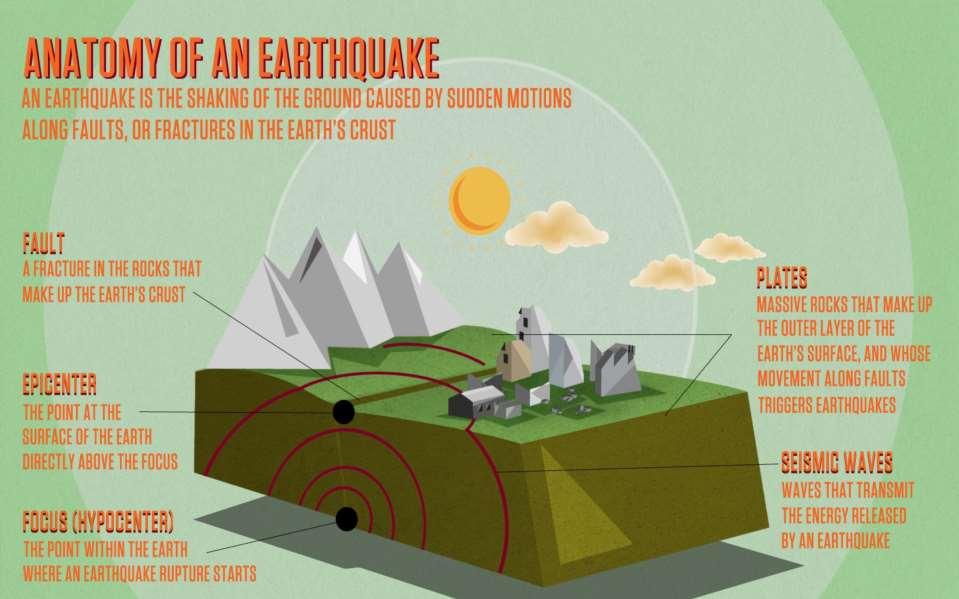
4 Earthquakes Earthquakes occur when rock underground suddenly breaks along a fault. This sudden release of energy causes the seismic waves that make the ground shake.
5 Tsunami Tsunamis are generated when geologic events cause large, rapid movements in the sea floor that displace the water column above. The Pacific Coast is at risk both from locally and distantly generated tsunamis.

6 Why earthquakes? 100 years ago German geophysicist Alfred Wegener Theory of Continental Drift Landmasses of Earth fit together Evidence of fossils on opposite sides of the ocean
7

8 1960s - Plate Tectonics
9 What are earthquakes?
10 Earthquake = fault rupture Rupture causes sudden release of strain energy Producing the shaking we experience as the earthquake Shock radiates out from rupture as seismic waves

11 Deep / Intraplate Deep quakes are usually less than M7.5. The 2001 Nisqually, Washington quake (M6.8). Damaging deep earthquakes occur every years. The seismic energy disperses over a much larger area. Damage is usually less than in a similar sized shallow quake. Few, if any, aftershocks occur. No tsunami expected, although landslides could trigger local tsunamis.

12 Shallow / Crustal Aftershocks are common and may cause further disruption. No tsunami expected, although there could be a local tsunami from landslides.
 7.4.")
13 Shallow / Crustal Strong shaking is generally seconds, although it could be longer in localized areas. Shallow quakes are usually less than magnitude (M) 7.4.
14 Shallow / crustal (Incomplete) List of magnitude 4.0 or larger earthquakes in Oregon SSW of Coos Bay, OR WNW of Salem, OR SSE of Walla Walla, WA (felt in OR) S of Portland, OR S of Tillamook, OR ENE of Baker, OR WNW of Adel, OR WNW of Grants Pass, OR

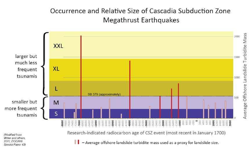
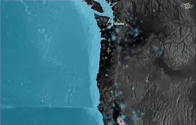
15 Hazard -- Shallow / Crustal Map showing earthquakes in last 48 hours Small shallow earthquakes are recorded every day in Cascadia; damaging quakes occur every few decades.
 and Scotts Mills (M5.6) in 1993.")
16 Shallow / Crustal Most crustal quakes are shallow, Klamath Falls (6.0) and Scotts Mills (M5.6) in Damage can be very heavy in the area of the epicenter and along the fault.
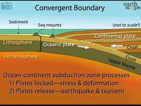
17 Subduction Zone

18 Ok, back to Cascadia

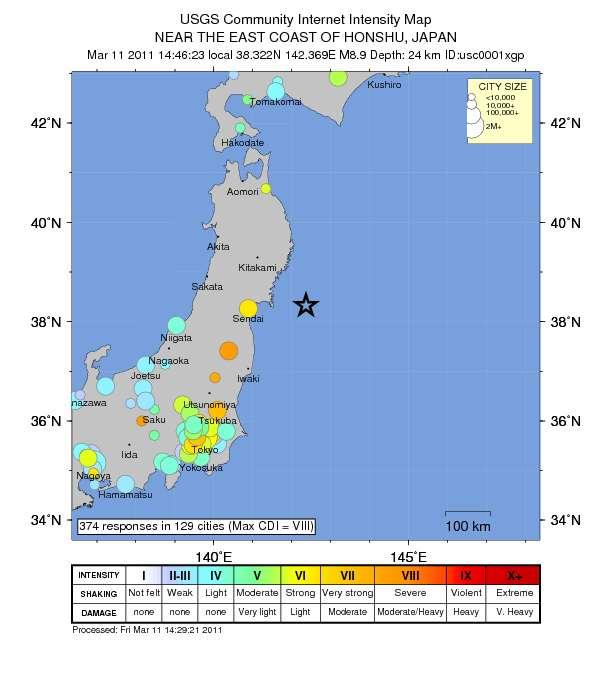
19 What is the Cascadia Subduction Zone?
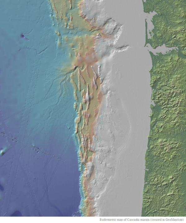
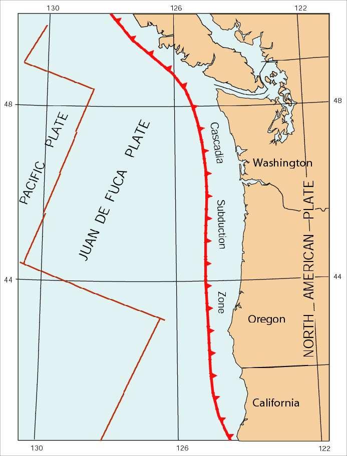
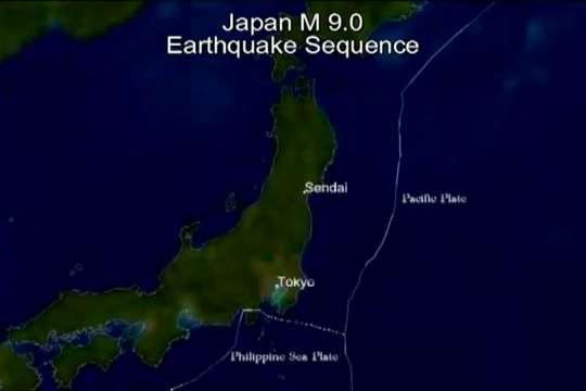
20
21 Know your Cascadia Subduction Zone 600 miles long, from northern California to British Columbia Capable of producing very large earthquakes (M9+) that impact a wide area Similar in size and impact to the 2004 Sumatra earthquake Can produce devastating tsunamis 37% chance of a mega-thrust earthquake in the next 50 years *
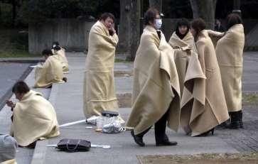
 5-600 years (entire length)")
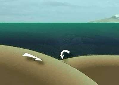
22 Last Cascadia Subduction Zone earthquake occurred in 1700 When will the next one occur? We just don t know Average recurrence: 240 years (south of Cape Blanco) years (entire length) 190-1,200 years between EQ

23 Recurrence Mw ~9 500 yrs Mw yrs Mw yrs Mw yrs (Modified from Goldfinger et al. (in press) by adding magnitude estimates and some labels)
24

25 Cascadia = Strong Shaking and Tsunami Strong Ground Shaking >8.0 Mw >2 min. shaking Tsunami within 15 to 25 minutes

26 What happens during a Cascadia Subduction Zone earthquake?


27 Strong ground shaking 1993 Molalla High School 2010 Haiti earthquake 2011 Tohoku earthquake

28 Shaking intensity CSZ in Lake Oswego Severe Strong Very Strong Source:

29 Compared to Japan 2011 EQ
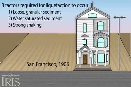
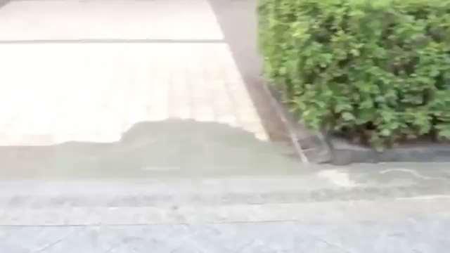
30


31 Coastal subsidence 2004 Sumatra People evacuate with small boats down a road flooded by the tsunami waves in the city of Ishinomaki in Miyagi prefecture_jiji PRESS_AFP_Getty Images
 and during an earthquake (bottom) Figure from Leonard et al")
32 Coastal coseismic subsidence Cartoon of crustal deformation due to fault locking between earthquakes (top) and during an earthquake (bottom) Figure from Leonard et al 2003.
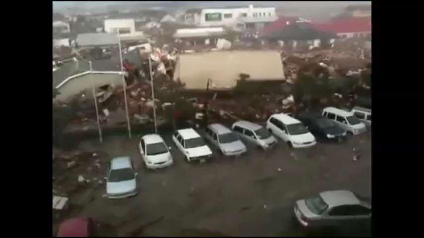
. Vertical rates colored according to their magnitude. Warm colors indicate uplift.")
33 Coseismic subsidence Maps of GPS horizontal velocities (left) and the combined GPS vertical velocities with tide and leveling uplift rates (right). Vertical rates colored according to their magnitude. Warm colors indicate uplift. (Gina Schmalzle)
34
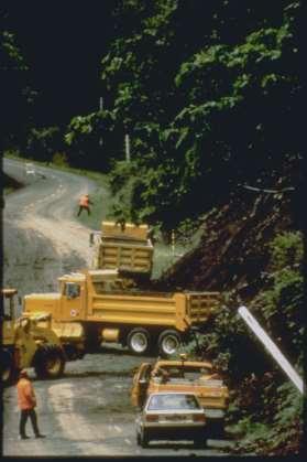
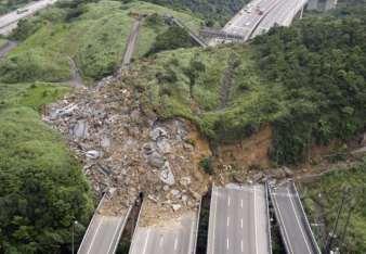
35 Landslides Japan Landslides in Ferndale, WA 2010 Taiwan
36
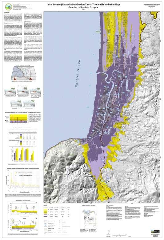
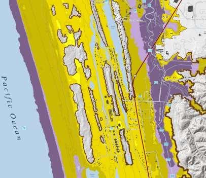
37

38 Astoria

39 Landslides in Jackson County


40 Liquefaction 1964 Niigata Liquefaction 2011 Christchurch Source: unknown 1964 Alaska
41
42

43 Liquefaction Source:
44 Tsunami
45 Tsunami

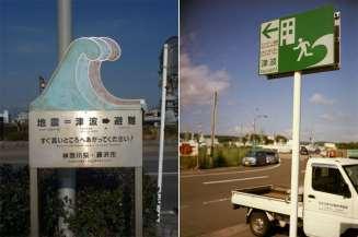
46 Tsunami 2004 Indonesian tsunami 2011 Tohoku tsunami
47 Tsunami Local Caused by a subduction zone earthquake near the Oregon shore Distant Caused by a subduction zone earthquake far away from the Oregon shore
48 Distant Tsunami Arrives 4 + hours after the earthquake Lower damage and flooding than local tsunamis National Tsunami Warning System can warn you Warning and Advisory require protective action National Tsunami Warning Center hrs

49 Tsunami Evacuation Maps
50 Tsunami Inundation Maps
51 Tsunami Evacuation Modeling Beat the Wave How long does it take to get out of the bad zone?
52 Distant Tsunami Earthquake Far Away You won t feel the ground shake 4+ hours before waves arrive Limited Inundation

53 Distant Tsunami Beaches Harbors Rivers, Inlets Other low-lying areas
54 Distant Tsunami Tsunami Alert Messages National Tsunami Warning Center Alert Level Threat Action Information Statement Minor waves at most No action suggested Watch Danger level not yet known Stay alert for more info Advisory Strong currents likely Stay away from the shore Warning Inundating waves possible Full evacuation suggested


55 Distant Tsunami Notification Mass Notification Systems Social Media NOAA Alert Radio TV/Radio Sirens

56 Evacuation Before a Distant Tsunami WHO: Only those in the distant tsunami zone HOW: Probably by car WHERE:???
57 Re-entry After a Distant Tsunami Cancellation Message Re-enter with Caution Damage Harbors Beaches Low-lying areas Roads, Bridges Clean up
58 Local Tsunami Arrives minutes after the earthquake Much higher waves Much further inland penetration NOAA Tsunami Warning System ineffective Earthquake = Only Warning NO OFFICIAL WARNING! Self Evacuation required

59 What Tohoku teaches us about Cascadia
60 Probability versus Possibility Planning assumptions led to inadequate mitigation (Probable) Response planning was based on a recurrence of the 1896 Meiji Sanriku or 1960 Chile tsunamis. (Possible) 869 Jogan earthquake and tsunami significantly larger viewed as an outlier, a 1,000-year event that was low probability. The planning scenario supposedly depicted a highprobability 100 year event.
61 Assumptions have human impact 22,600 persons killed or missing nationwide 15,500 confirmed deaths 92.4% drowning 107,000 buildings collapsed, and another 111,000 partially collapsed BUT. 6.5 million people live within 200 miles of rupture zone
62 Initial earthquake magnitude estimations feeds previous assumptions Earthquake initially estimated at 7.9M Tsunami warnings issued based on this false information Subsequently, magnitude was raised to 8.9, then 9.0 Earthquake damage caused power and telecommunication outages which prevented people from getting updated tsunami warnings
63 Factors affecting survival of tsunami Physical factors geography and topography distance to high ground pre-disaster land use

64 Factors affecting survival of tsunami Human factors time of the event limited mobility caregiving behavior inaccurate conclusions drawn from past tsunami experiences instinct to protect property

65 Survival factors: disaster preparedness Regularly practiced drills Saw other people evacuating
66 Recommendations Enhance tsunami evacuation routes where high ground available Harden infrastructure Clear wayfinding Practice, practice, practice Build vertical evacuation refuges where high ground is not available.

67 Embed tsunami information in ambient built environment R. Wilson
68 Japanese emergency response challenges. Scale of the tsunami disaster Infrastructure damage prevented early reporting of damage and response needs. Access to satellite telephones was limited and inadequate to fill the communications gap. Highway and rail lines along the coast were destroyed, and access from the major highways to the west was blocked in many places by road damage and landslides. Marine access from the Pacific Ocean side of Iwate, Miyagi, and Fukushima prefectures was blocked on the first day by continuing tsunami action, and later by damaged dock facilities and floating debris. Fuel for vehicles and equipment was not available due to loss of power and damage to facilities.
69 Responders as victims Many jurisdictions lost political and response personnel, Facilities destroyed. Otsuchi Lost mayor, seven senior staff, and 31 other municipal employees in the tsunami. Minamisanriku Emergency operations and tsunami warning center was destroyed. 10 staff members survived by clinging to antennas on the roof.
70 Recommendations: Ensure Critical Continuity Relocate critical facilities out of inundation zone Retrofit critical facilities Prohibit building new critical facilities in inundations zone Ensure future construction of critical facilities meet the most robust standards
71 Emergency Shelter and Housing About 470,000 evacuees required shelter Local governments are responsible for post-disaster care and sheltering with assistance provided by the national government
72 Challenges to sheltering Dependent on local government officials, undamaged facilities, and logistic support. Pre-designated shelters destroyed. In some areas, food and water were not delivered for up to three days. Sheltering - mix of planned and ad hoc
73 In-place sheltering People with places to stay with family or friends or staying in their own homes Barrier to information and services as those living in shelters. Impacted lifeline services and other amenities

74 Recommendations Robust sheltering planning Bring the message home Personal preparedness Neighborhood prep Community prep
75 Aftershocks

76 Aftershocks Great Japan Earthquake 3 aftershocks > 7Mw within 40 minutes Aftershock area 500 km x 200 km More than 9,500 aftershocks as of March 2012
77
 378-2911 ext. 22237 Althea.rizzo@state.or.")
78 Contact Information Geological Hazard Program Coordinator Althea Rizzo (503) ext
Cascadia Preparedness. Tsunami Road Show 2012
 Cascadia Preparedness Tsunami Road Show 2012 Why we re here talking about earthquakes and tsunamis. Getting from here to there What we ll be talking about Cascadia Subduction Zone March 11 Japanese earthquake
Surviving the Big One: Understanding and Preparing for a Major Earthquake in Western Oregon
 Surviving the Big One: Understanding and Preparing for a Major Earthquake in Western Oregon May 21, 2013 City of Salem Salem Public Library Althea Rizzo, Geological Hazards Program Coordinator Oregon Emergency
What is a tsunami? Capital Regional District Tsunami Frequently Asked Questions (FAQ s) Tsunami (soo-nah-mee)
 Tsunami (soo-nah-mee)") Tsunami (soo-nah-mee) Tsunamis (Japanese translation harbour wave ) are waves with a great distance between crests, and are caused by any widespread, sudden movement of large volumes of water. The tsunami
Tsunami (soo-nah-mee) Tsunamis (Japanese translation harbour wave ) are waves with a great distance between crests, and are caused by any widespread, sudden movement of large volumes of water. The tsunami
Cascadia Seismic Event Planning for the Maritime Community
 Cascadia Seismic Event Planning for the Maritime Community Jonathan Allan, Oregon Dept. of Geology and Mineral Industries Presentation to Annual Pacific Northwest Waterways Association Meeting (PNWA) October
Earthquake Hazards. Tsunami
 Earthquake Hazards Tsunami Review: What is an earthquake? Earthquake is the vibration (shaking) and/or displacement of the ground produced by the sudden release of energy. The point inside the Earth where
Three Fs of earthquakes: forces, faults, and friction. Slow accumulation and rapid release of elastic energy.
 Earthquake Machine Stick-slip: Elastic Rebound Theory Jerky motions on faults produce EQs Three Fs of earthquakes: forces, faults, and friction. Slow accumulation and rapid release of elastic energy. Three
Earthquake Hazards. Tsunami
 Earthquake Hazards Tsunami Review: What is an earthquake? Earthquake is the vibration (shaking) and/or displacement of the ground produced by the sudden release of energy. The point inside the Earth where
Earthquakes and Tsunamis
 Earthquakes and Tsunamis Kenji Satake Earthquake Research Institute University of Tokyo 1 Part I 2011 Tohoku earthquake and tsunami 2 Fukushima Dai ichi NPP accident Earthquake ground motion Reactors automatically
Earthquake Hazards. Tsunami
 Earthquake Hazards Tsunami Measuring Earthquakes Two measurements that describe the power or strength of an earthquake are: Intensity a measure of the degree of earthquake shaking at a given locale based
Disclaimer. This report was compiled by an ADRC visiting researcher (VR) from ADRC member countries.
 from ADRC member countries.") Disclaimer This report was compiled by an ADRC visiting researcher (VR) from ADRC member countries. The views expressed in the report do not necessarily reflect the views of the ADRC. The boundaries and
Disclaimer This report was compiled by an ADRC visiting researcher (VR) from ADRC member countries. The views expressed in the report do not necessarily reflect the views of the ADRC. The boundaries and
How to communicate Cascadia Subduction Zone earthquake hazards
 How to communicate Cascadia Subduction Zone earthquake hazards Tom Brocher Research Geophysicist Earthquake Science Center U.S. Geological Survey Menlo Park, California Seattle Post-Intelligencer Lessons
Earthquakes in Oregon: Past, Present & Future. Earthquakes in OREGON: Are we ready for the Big One?
 Earthquakes in Oregon: Past, Present & Future Earthquakes in OREGON: Are we ready for the Big One? Scott Burns Portland State University Department of Geology New Yorker Article: 7/20/15 The Really Big
Lessons Learned from Past Tsunamis Warning and Emergency Response
 UNESCO IOC CTIC US NOAA ITIC Regional Training Workshop on Strengthening Tsunami Warning and Emergency Response Standard Operating Procedures and the Development of the ICG/CARIBE-EWS PTWC New Enhanced
DRAFT - Tsunami Response Plan Playbook Santa Cruz Harbor Maritime Community
 DRAFT - Tsunami Response Plan Playbook Santa Cruz Harbor Maritime Community Page 1 Best to display on 11X17 paper Purpose and Use of this Real-time Tsunami Response Plan Playbook PURPOSE: This product
Introduction to Environmental Geology, 5e Case History: Indonesian Tsunami Indonesian Tsunami (2) Introduction Historic Tsunamis
 Introduction Historic Tsunamis") 1 2 3 4 5 6 7 8 9 Introduction to Environmental Geology, 5e Chapter 7 Tsunami Case History: Indonesian Tsunami December 26, 2004, within a few hours, close to 250,000 people were killed With no warning
1 2 3 4 5 6 7 8 9 Introduction to Environmental Geology, 5e Chapter 7 Tsunami Case History: Indonesian Tsunami December 26, 2004, within a few hours, close to 250,000 people were killed With no warning
The Three Things You Need to Know About Tsunami Preparedness Patrick Corcoran, Oregon Sea Grant,
 The Three Things You Need to Know About Tsunami Preparedness Patrick Corcoran, Oregon Sea Grant, 10.11.13 NSF/CEETEP Workshop for Coastal Educators, October 11-14, Astoria, OR The Bottom Line Giant Earthquakes
(energy loss is greater with longer wavelengths)
") GEOL 0820 Ramsey Natural Disasters Spring, 2018 LECTURE #9: Tsunami Monitoring & Mitigation Date: 8 February 2018 I. Characteristics (con t): shoaling: o process of wave height increase and breaking as
GEOL 0820 Ramsey Natural Disasters Spring, 2018 LECTURE #9: Tsunami Monitoring & Mitigation Date: 8 February 2018 I. Characteristics (con t): shoaling: o process of wave height increase and breaking as
Prevention Tsunami wall 10m high (breached by the tsunami due to land level falling by 3m)
") Plate margin Plates Causes Sendai, Japan Convergent plate margin Pacific and Eurasian Plates Convergent plate margin Sima (Pacific plate) moves towards the sial (Eurasian plate) Sima (Pacific plate) is
Plate margin Plates Causes Sendai, Japan Convergent plate margin Pacific and Eurasian Plates Convergent plate margin Sima (Pacific plate) moves towards the sial (Eurasian plate) Sima (Pacific plate) is
Introduction to Environmental Geology, 5e
 Lecture Presentation prepared by X. Mara Chen, Salisbury University Introduction to Environmental Geology, 5e Edward A. Keller Chapter 7 Tsunami Case History: Indonesian Tsunami December 26, 2004, within
KNOWLEDGE NOTE 5-1. Risk Assessment and Hazard Mapping. CLUSTER 5: Hazard and Risk Information and Decision Making. Public Disclosure Authorized
 Public Disclosure Authorized Public Disclosure Authorized Public Disclosure Authorized Public Disclosure Authorized KNOWLEDGE NOTE 5-1 CLUSTER 5: Hazard and Risk Information and Decision Making Risk Assessment
"The Big One" by sea and not by land
 "The Big One" by sea and not by land By Los Angeles Times, adapted by Newsela staff on 03.24.14 Word Count 629 Surfer Lee Johnson emerges from the water at San Onofre State Beach, Calif., with the twin
TSUNAMI and SEICHE DEFINITIONS:
 TSUNAMI and SEICHE DEFINITIONS: Seiche The action of a series of standing waves (sloshing action) of an enclosed body or partially enclosed body of water caused by earthquake shaking. Seiche action can
Magnitude 6.5 OFFSHORE NORTHERN CALIFORNIA
 A powerful offshore earthquake that struck near the Northern California coast left a hodgepodge of debris for communities to sort through Sunday but spared residents any serious injury. After 25,000 people
What Are Disasters? The Rescue Kids Trio!
 The Rescue Kids Trio! What Are Disasters? This manual was made possible through funding by the Council of Local Authorities for International Relations. Disasters and emergency preparedness Emergency preparedness
Tsunami waves swept away houses and cars in northern Japan and pushed ships aground.
 Japan was struck by a magnitude 8.9 earthquake off its northeastern coast Friday. This is one of the largest earthquakes that Japan has ever experienced. In downtown Tokyo, large buildings shook violently
Establishment and Operation of a Regional Tsunami Warning Centre
 Establishment and Operation of a Regional Tsunami Warning Centre Dr. Charles McCreery, Director NOAA Richard H. Hagemeyer Pacific Tsunami Warning Center Ewa Beach, Hawaii USA Why A Regional Tsunami Warning
Earthquakes, volcanic eruptions, tsunamis (why do we live here?) Tectonic plates. Tectonic plates: Juan de Fuca. Volcanism the past 37 million years
 Tectonic plates. Tectonic plates: Juan de Fuca. Volcanism the past 37 million years") Earthquakes, volcanic eruptions, tsunamis (why do we live here?) Tectonic plates Tectonic plates: Juan de Fuca Volcanism the past 37 million years Tectonic plates: Juan de Fuca Volcanism the past 37 million
Earthquakes, volcanic eruptions, tsunamis (why do we live here?) Tectonic plates Tectonic plates: Juan de Fuca Volcanism the past 37 million years Tectonic plates: Juan de Fuca Volcanism the past 37 million
Portland Water Bureau. Preparing Portland s Water Supply for The Big One. July 11, Tim Collins, P.E., G.E.
 Portland Water Bureau Preparing Portland s Water Supply for The Big One July 11, 2018 Tim Collins, P.E., G.E. Presentation Outline Portland water system overview Pacific Northwest seismic hazards Building
THE 2011 TOHOKU EARTHQUAKE IN JAPAN. VSU Lyuben Karavelov, Sofia, Bulgaria. Key words: Tohoku earthquake, strong ground motion, damage
 THE 2011 TOHOKU EARTHQUAKE IN JAPAN Radan Ivanov 1 VSU Lyuben Karavelov, Sofia, Bulgaria Abstract: This earthquake which occurred on March 11, 2011, had a magnitude of 9.0, which places it as the fourth
LOCAL TSUNAMIS: CHALLENGES FOR PREPAREDNESS AND EARLY WARNING
 LOCAL TSUNAMIS: CHALLENGES FOR PREPAREDNESS AND EARLY WARNING HARALD SPAHN 1 1 German Technical Cooperation International Services, Jakarta, Indonesia ABSTRACT: Due to the threat of local tsunamis warning
OREGON DEPARTMENT OF GEOLOGY & MINERAL INDUSTRIES
 OREGON DEPARTMENT OF GEOLOGY & MINERAL INDUSTRIES Mission: Provide Earth Science Information To Make Oregon Safe and Prosperous EARTHQUAKES & TSUNAMIS S Lidar Earthquake/Tsunami Science Educate & Mitigate
I. Locations of Earthquakes. Announcements. Earthquakes Ch. 5. video Northridge, California earthquake, lecture on Chapter 5 Earthquakes!
 51-100-21 Environmental Geology Summer 2006 Tuesday & Thursday 6-9:20 p.m. Dr. Beyer Earthquakes Ch. 5 I. Locations of Earthquakes II. Earthquake Processes III. Effects of Earthquakes IV. Earthquake Risk
Earthquakes. Building Earth s Surface, Part 2. Science 330 Summer What is an earthquake?
 Earthquakes Building Earth s Surface, Part 2 Science 330 Summer 2005 What is an earthquake? An earthquake is the vibration of Earth produced by the rapid release of energy Energy released radiates in all
What is an Earthquake?
 Earthquakes What is an Earthquake? Earthquake - sometimes violent shaking of ground caused by movement of Earth s tectonic plates; creates seismic waves Often followed by smaller earthquakes (aftershocks);
SCIENCE OF TSUNAMI HAZARDS
 SCIENCE OF TSUNAMI HAZARDS ISSN 8755-6839 Journal of Tsunami Society International Volume 29 Number 3 2010 POTENTIAL DEFICIENCIES IN EDUCATION, INSTRUMENTATION, AND WARNINGS FOR LOCALLY GENERATED TSUNAMIS
Dozens Killed after Earthquake in Lombok, Indonesia
 Dozens Killed after Earthquake in Lombok, Indonesia KEY POINTS 91 people have been killed and hundreds injured after a 6.9-magnitude earthquake struck Lombok, Indonesia on 05 August 2018. Widespread damage
BE INFORMED MAKE A PLAN BUILD TWO KITS CASCADIA MEDICAL READINESS LEARNING OBJECTIVES
 LEARNING OBJECTIVES CASCADIA MEDICAL READINESS The Cascadia Subduction Zone (CSZ) Earthquake s Impact on Central Oregon s Medical Care Characterize the consequences of disasters on health services Characterize
Hazards in the Seattle Area. Disaster Questions. Where Were You? Where Were You? Volcanoes St. Helens Adams, Rainier, Glacier, Baker
 Hazards in the Seattle Area Volcanoes St. Helens Adams, Rainier, Glacier, Baker Earthquakes Outer coast Puget Sound (Seattle Fault & others) Tsunami Outer coast Puget Sound (Seattle Fault & others) Disaster
The EEFIT Mission to Japan after the M W 9.0 Tōhoku Earthquake: Key Findings and Lessons Learned
 The EEFIT Mission to Japan after the M W 9.0 Tōhoku Earthquake: Key Findings and Lessons Learned By A. Pomonis (Team Leader) Director, Cambridge Architectural Research, Ltd. on behalf of the EEFIT Mission
Earthquake hazards. Aims 1. To know how hazards are classified 2. To be able to explain how the hazards occur 3. To be able to rank order hazards
 Earthquake hazards Aims 1. To know how hazards are classified 2. To be able to explain how the hazards occur 3. To be able to rank order hazards Types of hazard Primary A direct result of the earthquake
Wainui Beach Management Strategy (WBMS) Summary of Existing Documents. GNS Tsunami Reports
 Summary of Existing Documents. GNS Tsunami Reports") Wainui Beach Management Strategy (WBMS) Summary of Existing Documents GNS Tsunami Reports a) Review of Tsunami Hazard and Risk in New Zealand ( National Risk Report ) b) Review of New Zealand s Preparedness
Wainui Beach Management Strategy (WBMS) Summary of Existing Documents GNS Tsunami Reports a) Review of Tsunami Hazard and Risk in New Zealand ( National Risk Report ) b) Review of New Zealand s Preparedness
Unit 9 (packet #2): Volcanoes and Earthquakes
: Volcanoes and Earthquakes") Unit 9 (packet #2): Volcanoes and Earthquakes 13. Earthquakes are one of the most destructive natural forces. I can a. Explain what an earthquake is, where they occur and why they occur. b. Describe the
Unit 9 (packet #2): Volcanoes and Earthquakes 13. Earthquakes are one of the most destructive natural forces. I can a. Explain what an earthquake is, where they occur and why they occur. b. Describe the
Earthquakes. Earthquakes and Plate Tectonics. Earthquakes and Plate Tectonics. Chapter 6 Modern Earth Science. Modern Earth Science. Section 6.
 Earthquakes Chapter 6 Modern Earth Science Earthquakes and Plate Tectonics Section 6.1 Modern Earth Science Earthquakes and Plate Tectonics Earthquakes are the result of stresses in Earth s s lithosphere.
We have previously looked at artificial seismograms such as this one here.
 We have previously looked at artificial seismograms such as this one here. S P A realistic Seismic Record Each vertical line = 1 minute Each horizontal line = 15 minutes Seismic station PMM is in Parkfield,
Earthquake prediction. Southwest BC: Our local dangerous fault zones
 Earthquake prediction Prediction: specifies that an earthquake of a specific magnitude will occur in a defined region during a particular period: There will be a M 7 or larger earthquake in southern California
Tsunami! Beyond the Book. FOCUS Book
 FOCUS Book Use the engineering design process to design a structure that will protect a coastal town from possible tsunami damage. Brainstorm design ideas for your structure with a group of classmates.
Finding an Earthquake Epicenter Pearson Education, Inc.
 Finding an Earthquake Epicenter Measuring the Size of Earthquakes Two measurements that describe the size of an earthquake are: 1. Intensity a measure of the degree of earthquake shaking at a given locale
This article is provided courtesy of the American Museum of Natural History.
 Avoiding Earthquake Surprises in the Pacific Northwest This article is provided courtesy of the American Museum of Natural History. How Vulnerable Is the Pacific Northwest? Cascadia is a region in the
Usually, only a couple of centuries of earthquake data is available, much shorter than the complete seismic cycle for most plate motions.
 Earthquake Hazard Analysis estimate the hazard presented by earthquakes in a given region Hazard analysis is related to long term prediction and provides a basis to expressed hazard in probabilistic terms.
9.3. Earthquakes. Earthquakes at Divergent Boundaries
 9.3 Earthquakes Preview the headings on these two pages. What can you say about where earthquakes occur? As the plates that make up Earth s crust move, the rough edges lock together. Over time, pressure
7.3 Magnitude Earthquake Strikes Iran-Iraq Border
 7.3 Magnitude Earthquake Strikes Iran-Iraq Border KEY POINTS A magnitude 7.3 earthquake has struck the Iran-Iraq border with at least 348 fatalities reported. Thousands more have been injured and many
Earthquake prediction. Earthquake prediction: animals?
 Earthquake prediction Prediction: specifies that an earthquake of a specific magnitude will occur in a defined region during a particular period: There will be a M 7 or larger earthquake in southern California
The Cascading Hazards from Cascadia s Earthquakes
 Tsunamis The Cascading Hazards from Cascadia s Earthquakes Earthquakes (Nisqually earthquake, Seattle, WA) Volcanoes (Mt St Helens eruption, WA) Joan Gomberg gomberg@usgs.gov Landslides (Oso landslide,
Preparing for the BIG one Cascadia Subduction Zone Event
 Preparing for the BIG one Cascadia Subduction Zone Event Source - 2016 CZS Excercise updated Jan 2015 1 Earthquake Faults in Washington State Emergency Management Ring of Fire The Ring of Fire accounts
Coseismic slip model
 Figure 3 - Preliminary highly smoothed model of coseismic slip for the 11 March UCL Institute for Risk & Disaster Reduction Magnitude 9.0 (JMA scale) earthquake Occurred at 02:46:23 pm local time near
Indian Ocean Tsunami Warning System: Example from the 12 th September 2007 Tsunami
 Indian Ocean Tsunami Warning System: Example from the 12 th September 2007 Tsunami Charitha Pattiaratchi 1 Professor of Coastal Oceanography, The University of Western Australia Email: chari.pattiaratchi@uwa.edu.au
Tectonic Processes and Hazards Enquiry Question 1: Why are some locations more at risk from tectonic hazards?
 Tectonic Processes and Hazards Enquiry Question 1: Why are some locations more at risk from tectonic hazards? Key words Basalt Andesite Rhyolite Benioff Zone Subduction zone Crustal fracturing Definition
REPORT ON THE TOHOKU AREA PASIFIC OFFSHORE EARTHQUAKE
 REPORT ON THE TOHOKU AREA PASIFIC OFFSHORE EARTHQUAKE GENERAL PERSPECTIVE The Highest Magnitude Ever Recorded The 2011 off the Pacific Coast of Tohoku Earthquake (hereafter, the 2011 Tohoku- Pacific Earthquake
Sendai Earthquake NE Japan March 11, Some explanatory slides Bob Stern, Dave Scholl, others updated March
 Sendai Earthquake NE Japan March 11, 2011 Some explanatory slides Bob Stern, Dave Scholl, others updated March 14 2011 Earth has 11 large plates and many more smaller ones. Plates are 100-200 km thick
Earthquakes and Earthquake Hazards Earth - Chapter 11 Stan Hatfield Southwestern Illinois College
 Earthquakes and Earthquake Hazards Earth - Chapter 11 Stan Hatfield Southwestern Illinois College What Is an Earthquake? An earthquake is the vibration of Earth, produced by the rapid release of energy.
Lessons from the 2004 Sumatra earthquake and the Asian tsunami
 Lessons from the 2004 Sumatra earthquake and the Asian tsunami Kenji Satake National Institute of Advanced Industrial Science and Technology Outline 1. The largest earthquake in the last 40 years 2. Tsunami
4-3-1 Earthquake and Tsunami Countermeasures of Tokyo s
 4-3-1 Earthquake and Tsunami Countermeasures of Tokyo s Sewerage Masahiro Hikino* and Gaku Sato** *Planning Section, Planning and Coordinating Division, Bureau of Sewerage, Tokyo Metropolitan Government
What causes tsunamis?
 What causes tsunamis? Any movement/displacement of the ocean floor can generate the energy that forms a tsunami. However, tsunamis are usually generated by large, shallow earthquakes, which have epicenters
Magnitude 7.0 N of ANCHORAGE, ALASKA
 A magnitude 7.0 earthquake occurred just before 8:30 am local time 8 miles north of Anchorage at a depth of 40.9 km (25.4 miles). There are reports of major infrastructure damage and damage to many homes
Earthquakes Earth, 9th edition, Chapter 11 Key Concepts What is an earthquake? Earthquake focus and epicenter What is an earthquake?
 1 2 3 4 5 6 7 8 9 10 Earthquakes Earth, 9 th edition, Chapter 11 Key Concepts Earthquake basics. "" and locating earthquakes.. Destruction resulting from earthquakes. Predicting earthquakes. Earthquakes
Forces in Earth s Crust
 Name Date Class Earthquakes Section Summary Forces in Earth s Crust Guide for Reading How does stress in the crust change Earth s surface? Where are faults usually found, and why do they form? What land
Magnitude 7.6 SOUTH OF IQUIQUE, CHILE
 A powerful aftershock struck off northern Chile prompting an evacuation of the coastal area and raising fears of a tsunami. This magnitude 7.6 earthquake is the largest of a series of aftershocks following
Earthquakes. Earthquake Magnitudes 10/1/2013. Environmental Geology Chapter 8 Earthquakes and Related Phenomena
 Environmental Geology Chapter 8 Earthquakes and Related Phenomena Fall 2013 Northridge 1994 Kobe 1995 Mexico City 1985 China 2008 Earthquakes Earthquake Magnitudes Earthquake Magnitudes Richter Magnitude
Lecture Outline Wednesday-Monday April 18 23, 2018
 Lecture Outline Wednesday-Monday April 18 23, 2018 Questions? Lecture Final Exam Lecture Section 1 Friday May 4, 8:00-10:00am Lecture Section 2 Friday May 4, 3:10-5:10 pm Final Exam is 70% new material
New Pig Corporation newpig.com HOT-HOGS Page 1 of 10
 Develop a Disaster Preparedness Plan Assess your risks of natural and manmade disasters Purchase adequate insurance and ensure that you have the types of coverage you may need Keep employee contact information
Natural Disasters. Why Are There Earthquakes? 197 words. The Power of the Earth 221 words. Big Waves! 188 words
 ARTICLE-A-DAY Natural Disasters 6 Articles Check articles you have read: Why Are There Earthquakes? 197 words The Power of the Earth 221 words Big Waves! 188 words The Volcano That Keeps Erupting 228 words
VIDEO The 2011 Japanese Earthquake and Tsunami
 VIDEO The 2011 Japanese Earthquake and Tsunami Why was it so large and devastating? Why so short a warning? Why did tsunami precautions fail? What happened elsewhere? The Loma Prieta Earthquake (1989)
Deadly Earthquake Strikes Peru
 Deadly Earthquake Strikes Peru KEY POINTS On 14 January 2018, a magnitude-7.1 earthquake struck off the coast of Peru. At least two people have been reported dead, with dozens more left injured or homeless.
TSUNAMI and SEICHE DEFINITIONS:
 TSUNAMI and SEICHE DEFINITIONS: Seiche A series of standing waves (sloshing action) of an enclosed body or partially enclosed body of water caused by earthquake shaking. Seiche action can affect harbors,
UGRC 144 Science and Technology in Our Lives/Geohazards
 UGRC 144 Science and Technology in Our Lives/Geohazards Session 3 Understanding Earthquakes and Earthquake Hazards Lecturer: Dr. Patrick Asamoah Sakyi Department of Earth Science, UG Contact Information:
Hayden Island. i t. a u. p e. e k. By your Neighborhood Emergency Team
 Hayden Island n o i t a r a p e r P e k a u q h Eart By your Neighborhood Emergency Team Who are Hayden Island Nets? Your neighbors Completed 30 hr training from Fire Bureau and Portland Emergency Management
REPORT TO THE PLANNING, TRANSPORTATION AND PROTECTIVE SERVICES COMMITTEE MEETING OF JUNE 26, 2013
 PPS/PS 2013-07 REPORT TO THE PLANNING, TRANSPORTATION AND PROTECTIVE SERVICES COMMITTEE MEETING OF JUNE 26, 2013 SUBJECT UPDATES TO THE CAPITAL REGIONAL DISTRICT MODELLING OF POTENTIAL TSUNAMI INUNDATION
What causes a tsunami?
 Listen: Have this page read to you [1] Have this page read to you [2] A tsunami is a series of waves in the sea caused by a movement on the sea floor. New Zealand is at risk from tsunami because it has
Chapter 4 Earthquakes and Tsunamis
 Geology of the Hawaiian Islands Class 21 30 March 2004 100 100 100 96 A B C D F Exam Scores 95 94 94 90 85 83 83 83 Mean 72 67 61 59 59 55 54 41 Mean = 78.5 Median = 83 Any Questions? Chapter 4 Earthquakes
Chapter 4 Earthquakes and Tsunamis. Geology of the Hawaiian Islands. Any Questions? Class March Mean = 78.
 Geology of the Hawaiian Islands Class 21 30 March 2004 Any Questions? 100 100 100 96 A B C D F Exam Scores 95 94 94 90 85 83 83 83 Mean 72 67 61 59 59 55 54 41 Mean = 78.5 Median = 83 Chapter 4 Earthquakes
EMERGENCY WARNING SYSTEM PROCEDURES FOR DEBRIS FLOWS IN WESTERN OREGON
 EMERGENCY WARNING SYSTEM PROCEDURES FOR DEBRIS FLOWS IN WESTERN OREGON Updated: 12/03/2007 by the Oregon Department of Forestry and the Oregon Department of Geology and Mineral Industries Debris flows
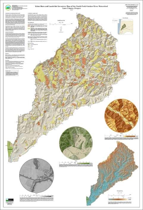
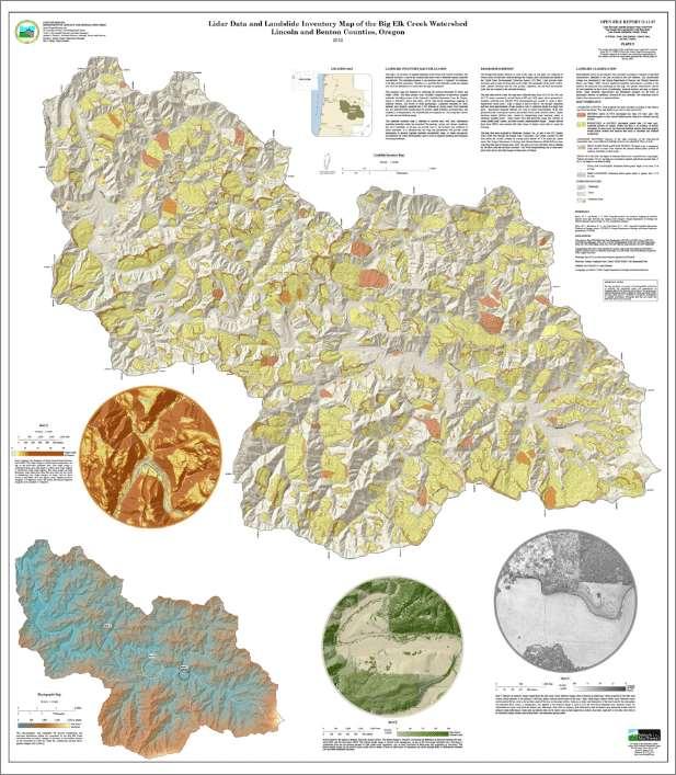
Interpretive Map Series 24
 Oregon Department of Geology and Mineral Industries Interpretive Map Series 24 Geologic Hazards, and Hazard Maps, and Future Damage Estimates for Six Counties in the Mid/Southern Willamette Valley Including
Mondo Quake in Pacific Northwest? By Leander Kahney
 Introduction to College Reading D Natural Disasters: Earthquake NAME I. Pre-reading. Discuss the following topics with other students at your table. What countries or regions of the world have earthquakes?
Earthquakes and Earth s Interior
 - What are Earthquakes? Earthquakes and Earth s Interior - The shaking or trembling caused by the sudden release of energy - Usually associated with faulting or breaking of rocks - Continuing adjustment
The Earthquake Cycle Chapter :: n/a
 The Earthquake Cycle Chapter :: n/a A German seismogram of the 1906 SF EQ Image courtesy of San Francisco Public Library Stages of the Earthquake Cycle The Earthquake cycle is split into several distinct
JMA Tsunami Warning Services. Tomoaki OZAKI Senior Coordinator for Tsunami Forecast Modeling Japan Meteorological Agency
 JMA Tsunami Warning Services Tomoaki OZAKI Senior Coordinator for Tsunami Forecast Modeling Japan Meteorological Agency Organization Chart of the Government of Japan Cabinet Office Diet Ministry of Internal
PERSONAL DISASTER PREPAREDNESS
 PERSONAL DISASTER PREPAREDNESS WHY PREPARE? Saves Lives Protects Property Speeds Recovery Preparedness Minimizes Panic and Confusion Prepares for Recovery Earthquakes If you re prepared for Earthquakes,
Internal / External Processes Create? Major External Processes Driven by energy from the sun and from gravity. Also create hazards and resources.
 ES 10 September 2018 Geologic Processes and Hazards Geology: scientific study of Earth s materials and processes Materials: what are these, list as many as you can External & Internal Processes: list several
Tsunami. Harry Yeh Oregon State University. Eastern Japan Earthquake Disaster Briefing at PEER: April 28, 2011
 Tsunami by Harry Yeh Oregon State University Eastern Japan Earthquake Disaster Briefing at PEER: April 28, 2011 Seismic Characteristics Rupture Model (Harvard Seismology) The fault rupture process was
ShakeAlert Earthquake Early Warning
 ShakeAlert Earthquake Early Warning Doug Given USGS, Pasadena Earthquake Program, Early Warning Coordinator 10 seconds 50 seconds 90 seconds USGS Earthquake Hazard Responsibilities USGS has the lead federal
Seismic Activity and Crustal Deformation after the 2011 Off the Pacific Coast of Tohoku Earthquake
 J-RAPID Symposium March 6-7, 2013 Seismic Activity and Crustal Deformation after the 2011 Off the Pacific Coast of Tohoku Earthquake Y. Honkura Tokyo Institute of Technology Japan Science and Technology
Natural Disasters Spring, LECTURE #8: Earthquake Disasters: Monitoring & Mitigation. Date: 1 Feb 2018 (lecturer: Dr.
 GEOL 0820 Ramsey Natural Disasters Spring, 2018 LECTURE #8: Earthquake Disasters: Monitoring & Mitigation Date: 1 Feb 2018 (lecturer: Dr. Shawn Wright) I. Exam I - Reminder Feb 6 th next class details:
March 11, 2011 Japanese Tsunami
 John Fassell March 11, 2011 Japanese Tsunami An earthquake occurred 30 miles under ground which lifted the seafloor Incoming wave as seen from shore Tsunami up to 130 feet tall in Miyako, JA that averaged
RECENT COMPREHENSIVE TSUNAMI MODELING FOR COASTAL OREGON
 RECENT COMPREHENSIVE TSUNAMI MODELING FOR COASTAL OREGON Speaker: George R. Priest, Oregon Dept. of Geology and Mineral Industries Pardee Keynote Symposium Great Earthquakes, the Cascadia Subduction Zone,
Surviving Tsunamis on the Oregon Coast
 Slide 1 Surviving Tsunamis on the Oregon Coast Coastal Engineers Think Inside the Box This talk generally covers civil engineering, coastal engineering, and how engineers work within limitations to create
Major External Processes Driven by energy from the sun and from gravity. Also create hazards and resources.
 Geologic Processes and Hazards Definition of Geology External and Internal Processes: examples of each Fundamentals of Plate Tectonics: definition, types of boundaries, general geography, hazards & resources
Earthquakes.
 Earthquakes http://thismodernworld.com/comic-archive Elastic rebound http://projects.crustal.ucsb.edu/understanding/elastic/rebound.html Elastic rebound Rocks store energy elastically When stored stress
ANALYSIS OF EVACUATION BEHAVIORS IN DIFFERENT AREAS BEFORE AND AFTER THE GREAT EAST JAPAN EARTHQUAKE
 Fifth International Conference on Geotechnique, Construction Materials and Environment, Osaka, Japan, Nov. 16-18, 2015, ISBN: 978-4-9905958-4-5 C3051 ANALYSIS OF EVACUATION BEHAVIORS IN DIFFERENT AREAS
Seismic Vulnerabilities of Multnomah County s Willamette River Bridges November 6, 2014
 Seismic Vulnerabilities of Multnomah County s Willamette River Bridges November 6, 2014 Ian Cannon, P.E. - Multnomah County Bridge Division Steve Drahota, P.E. - HDR Engineering, Inc. Response to the Budget
Hurricane Matthew Threats and Impacts Briefing for Eastern NC
 Hurricane Matthew Threats and Impacts Briefing for Eastern NC October 6 th, 2016 Date/Time Created: 10/6/2016, Noon EDT National Weather Service Newport/Morehead City, NC Hurricane Matthew Key Points Changes