Principles of the Global Positioning System Lecture 24
|
|
|
- Eustacia Glenn
- 6 years ago
- Views:
Transcription
1 Principles of the Global Positioning System Lecture 24 Prof. Thomas Herring
2 OVERVIEW Examination of results from Earthscope Reference frame definition: SNARF High-rate GPS results Episodic Tremor and Slip (ETS) events Two types of water events. Tools 05/14/ Lec 24 2
3 PBO GPS Data Analysis ACs (NMT and CWU) are routinely generating PBO GPS data products Rapid Sinex files: 24 hour latency Final Sinex files: 6-13 day latency, weekly run started after IGS final products become available Supplemental Sinex files: 12-week latency, weekly run. Includes missed sites and a 3-4 tie sites from final runs to link network. Tests show performance similar to finals. Bias fixing not quite so good due typically to wider site spacing. Supplemental runs also add sites to original final submission (until reprocessing generates new set of final runs). SINEX and RMS files ftp d to MIT Recently campaign processing (Bob Smith) added to processing first as an additional run similar to the supplemental runs and once caught up, included in the supplementals. Added USGS processing of SCIGN sites (SCEC funding). Results appear in combined product. 05/14/ Lec 24 3
4 PBO Combination Analysis ACC: Rotates, translates, and scales each AC to PBO SNARF reference frame; check and correct meta data (when possible) Combine AC results and transforms combined product to PBO SNARF (Stable North America Reference Frame) Outlier checks and report generated that is ed to SINEX and time-series files sent to UNAVCO via LDM The PBO realization of SNARF is updated about once-per-year: Requires re-submission of all frame defined sinex files and time series files. Latest version At 6-month intervals updates are made for new stations. (Reference frame sites are not updated in these incremental updates and thus the time series and SINEX do not need release. 05/14/ Lec 24 4


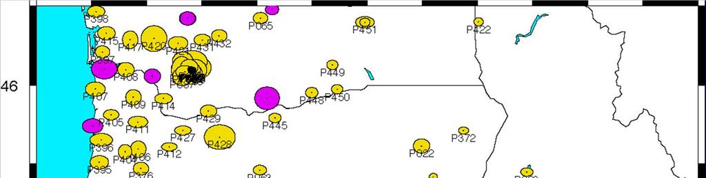
5 PBO SNARF Reference Frame Red: IGS reference sites Yellow PBO/ Nucleus sites 254 sites used to estimate daily rotation, translation and scale onto the North America Frame. Outlier detection during estimation. 05/14/ Lec 24 5
6 RMS daily scatter: PBO Sites Daily RMS Scatters for Combined solution for PBO Sites Median North 1.1 mm Median East 1.4 mm Median Height 3.9 mm 05/14/ Lec 24 6
7 Daily RMS Scatters: Nucleus Sites Daily RMS Scatters for Combined solution for Nucleus Sites Median North Median East Median Height 1.2 mm 1.4 mm 4.2 mm Nucleus are preexisting GPS sites that will be merged into PBO at the end of construction (10/2008). 05/14/ Lec 24 7
.Red circle shows 1 mm RMS scatter 05/14/12 12.")
8 RMS scatters for Nucleus sites (purple) and PBO sites (yellow), RMS scatter > 3 mm (black, 1mm).Red circle shows 1 mm RMS scatter 05/14/ Lec 24 8
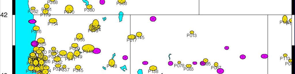
9 Northern California sites 05/14/ Lec 24 9

10 Alaskan Sites RMS scatter of these sites is higher than CONUS; regional frame stabilization yields only small improvement. 05/14/ Lec 24 10
11 Central US The RG sites are mostly only processed by CWU and the results are very noisy. Only one the RG sites is meant to be processed by CWU. 05/14/ Lec 24 11


12 SCIGN site analysis: These results have implications for how well external or campaign processing can incorporated into PBO. Current analysis looks very good. 05/14/ Lec 24 12
13 RMS Scatter of merged SGIGN sites Quality is very similar to other PBO sites. Median North Median East Median Height 1.1 mm 1.3 mm 3.8 mm 05/14/ Lec 24 13

14 Arrival of surface waves from San Simeon Earthquake (1-Hz) GPS stations around Parkfield operate at 1-Hz sampling rates, which allows us to study surface wave arrivals from nearby and large magnitude earthquakes 05/14/ Lec 24 14

15 Time zoom of arrivals In addition to the surface waves, the static co-seismic offset can also be seen here. Real time high rate GPS data useful for surveying and engineering communities. 05/14/ Lec 24 15
16 Episodic Tremor and Slip (ETS) events in Casadia (Pacific North West) Examine overlay of strainmeter results and GPS coordinates Strainmeters measure small displacements in bore-hole (10-cm diameter) to measure strain (dl/l). GPS measures the integrated effects of all strains between site and stable North America. Strain meter data downloaded from: level 2 processed data (ASCII form) Files give gauge data calibrated to strain units with corrections offsets, trends and tides. Four gauge readings converted to 3 components of strain in east, north and EN directions (Eee-Enn, Eee+Enn, 2Een) through gauge orientations and least-squares (could test rms here). Eee-Enn strain compared GPS East coordinates after removing polynomial from strain. Data available in a number of formats including SEED 05/14/ Lec 24 16

17 Borehole strainmeter GPS comparison Transient appears shorter in strain record? However is this expected from spatially transient strain event: Position will see continued integration Green line includes tides 05/14/ Lec 24 17

18 Comparison in Northern Casadia/Vancouver Island Again short strain event but here earlier signal in Nov 2006 not seen in GPS. 05/14/ Lec 24 18

19 Motions in California Red vectors relative to North America; Blue vectors relative to Pacific Motion across the plate boundary is ~50 mm/yr. In 100-years this is 5 meters of motion which is released in large earthquakes 05/14/ Lec 24 Look at motion here 19

20 05/14/ Lec 24 20
")


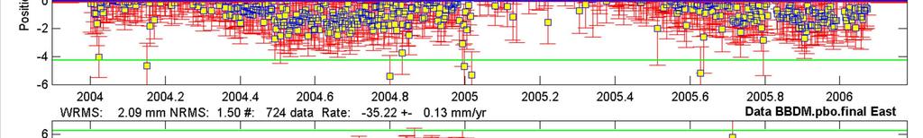
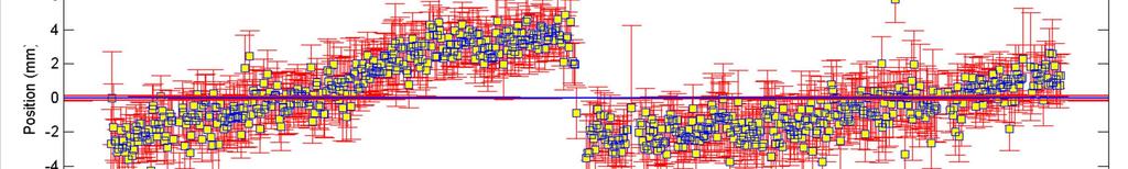
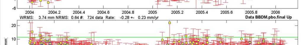
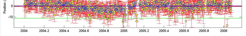
21 Site BBDM (using GoogleEarth) Courtesy of MDA EarthSat. Used with permission. 05/14/ Lec 24 21
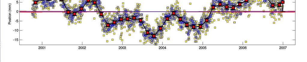
22 Water level in DAM versus site east coordinate 05/14/ Lec 24 22
23 Closer Look (water change is rapid) 05/14/ Lec 24 23


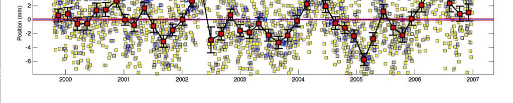
24 Another Water effect 2005-Anomaly Baldwin Park Areas Velocity Legend Red: ; Blue ; Black /14/ Lec 24 Examine 3 sites 24


25 Trend fit 05/14/ Lec 24 25

26 05/14/ Lec 24 26

27 05/14/ Lec 24 27
 95% confidence ellipses Grey scaled version of 2005 rate 05/14/12 12.")
28 Baldwin Hills Velocity anomaly Change in velocity ( ) minus ( ) 95% confidence ellipses Grey scaled version of 2005 rate 05/14/ Lec 24 Rapid response thought be due to water; reason for long term change not clear 28
29 Summary of Water Effects While onset on motion in 2005 in Baldwin region coincides with heavy rains; the motions in this region continue well after the end of rains. BBDM: Dam site shows rapid response to water changes in the dam and so effect in basin seem to be of a different nature. 05/14/ Lec 24 29


30 Cautions: Bad antenna artifact (several sites of this nature) 05/14/ Lec 24 30
31 Repeating slow earthquakes in Pacific North West Image removed due to copyright restrictions. Please see: Larson, K., P. Bodin, and J. Gomberg. Using 1 Hz GPS Data to Measure Deformations Caused by the Denali Fault Earthquake. Science 300 (2003): Example of repeating slow earthquakes (no rapid rupture) These events give insights into material properties and nature of time dependence of deformation 05/14/ Lec 24 31


32 GPS Measured propagating seismic waves Data from 2002 Denali earthquake 05/14/ Lec 24 32
33 Tools Most modern GPS analyses now contain hundreds of GPS sites For the remainder of the lecture we examine results with the GAMIT/GLOBK matlab tools available at: Current programs are velview and tsview. 05/14/ Lec 24 33
34 MIT OpenCourseWare Principles of the Global Positioning System Spring 2012 For information about citing these materials or our Terms of Use, visit:
Principles of the Global Positioning System Lecture 23
 12.540 Principles of the Global Positioning System Lecture 23 Prof. Thomas Herring 05/12/03 12.540 Lec 23 1 OVERVIEW Run through HW 03. Final lecture: Application area and GPS results Analysis of contemporary
Lab 9: Satellite Geodesy (35 points)
") Lab 9: Satellite Geodesy (35 points) Here you will work with GPS Time Series data to explore plate motion and deformation in California. This lab modifies an exercise found here: http://www.unavco.org:8080/cws/pbonucleus/draftresources/sanandreas/
Lab 9: Satellite Geodesy (35 points) Here you will work with GPS Time Series data to explore plate motion and deformation in California. This lab modifies an exercise found here: http://www.unavco.org:8080/cws/pbonucleus/draftresources/sanandreas/
Exploring Plate Motion and Deformation in California with GPS
 Exploring Plate Motion and Deformation in California with GPS Cate Fox-Lent, UNAVCO Master Teacher; Andy Newman, Georgia Institute of Technology; Shelley Olds, UNAVCO; revised by Nancy West Part 1: Analyze
Plate Boundary Observatory Working Group for the Central and Northern San Andreas Fault System PBO-WG-CNSA
 Plate Boundary Observatory Working Group for the Central and Northern San Andreas Fault System PBO-WG-CNSA Introduction Our proposal focuses on the San Andreas fault system in central and northern California.
GPS Strain & Earthquakes Unit 5: 2014 South Napa earthquake GPS strain analysis student exercise
 GPS Strain & Earthquakes Unit 5: 2014 South Napa earthquake GPS strain analysis student exercise Strain Analysis Introduction Name: The earthquake cycle can be viewed as a process of slow strain accumulation
Principles of the Global Positioning System Lecture 14
 12.540 Principles of the Global Positioning System Lecture 14 Prof. Thomas Herring http://geoweb.mit.edu/~tah/12.540 Propagation Medium Propagation: Signal propagation from satellite to receiver Light-time
GPS Strain & Earthquakes Unit 3: Finding location and velocity data for PBO GPS stations
 GPS Strain & Earthquakes Unit 3: Finding location and velocity data for PBO GPS stations Original activity by Vince Cronin (Baylor University). Revisions by Beth Pratt-Sitaula (UNAVCO). Analyzing the velocities
Lecture 20: Slow Slip Events and Stress Transfer. GEOS 655 Tectonic Geodesy Jeff Freymueller
 Lecture 20: Slow Slip Events and Stress Transfer GEOS 655 Tectonic Geodesy Jeff Freymueller Slow Slip Events From Kristine Larson What is a Slow Slip Event? Slip on a fault, like in an earthquake, BUT
to: Interseismic strain accumulation and the earthquake potential on the southern San
 Supplementary material to: Interseismic strain accumulation and the earthquake potential on the southern San Andreas fault system by Yuri Fialko Methods The San Bernardino-Coachella Valley segment of the
Variations in Tremor Activity and Implications for Lower Crustal Deformation Along the Central San Andreas Fault
 Variations in Tremor Activity and Implications for Lower Crustal Deformation Along the Central San Andreas Fault David R. Shelly USGS, Menlo Park Shelly and Hardebeck, GRL, 2010 Collaborators: Jeanne Hardebeck
TEGAM s Connection to the EarthScope Project
 TEGAM s Connection to the EarthScope Project Introduction The EarthScope Project is an undertaking funded by the National Science Foundation in partnership with the United States Geological Survey and
Segmentation in episodic tremor and slip all along Cascadia
 Segmentation in episodic tremor and slip all along Cascadia Michael R. Brudzinski and Richard M. Allen Geology 35 (10) 907-910, 2007, doi: 10.1130/G23740A.1 Data Repository: Methods for Automated Data
The San Andreas Fault Observatory at Depth: Recent Site Characterization Studies and the 2.2-Km-Deep Pilot Hole
 The San Andreas Fault Observatory at Depth: Recent Site Characterization Studies and the 2.2-Km-Deep Pilot Hole Steve Hickman and Bill Ellsworth (USGS) Mark Zoback (Stanford University) and the Pre-EarthScope
Your Advisor Said, Get the GPS Data and Plot it. Jeff Freymueller Geophysical University of Alaska Fairbanks
 Your Advisor Said, Get the GPS Data and Plot it Jeff Freymueller Geophysical Ins@tute University of Alaska Fairbanks Actual GPS Data GPS Data are phase and pseudorange data that measure distances to satellites.
S e i s m i c W a v e s
 Project Report S e i s m i c W a v e s PORTLAND STATE UNIVERSITY PHYSICS 213 SPRING TERM 2005 Instructor: Dr. Andres La Rosa Student Name: Prisciliano Peralta-Ramirez Table Of Contents 1. Cover Sheet 2.
Regional deformation and kinematics from GPS data
 Regional deformation and kinematics from GPS data Jessica Murray, Jerry Svarc, Elizabeth Hearn, and Wayne Thatcher U. S. Geological Survey Acknowledgements: Rob McCaffrey, Portland State University UCERF3
Jack Loveless Department of Geosciences Smith College
 Geodetic constraints on fault interactions and stressing rates in southern California Jack Loveless Department of Geosciences Smith College jloveless@smith.edu Brendan Meade Department of Earth & Planetary
IGS Reprocessing. and First Quality Assessment
 IGS Reprocessing Summary of Orbit/Clock Combination and First Quality Assessment Gerd Gendt, GeoForschungsZentrum Potsdam Jake Griffiths, NOAA/National Geodetic Survey Thomas Nischan, GeoForschungsZentrum
High Rate GPS Solutions
 High Rate GPS Solutions High rate GPS data (1 Hz or higher) Network solution Fixed a local reference clock Bias fixed Sub daily position estimates solutions Position becomes stochastic parameter Fairly
Plate Boundary Observatory the first five years
 www.earthscope.org Plate Boundary Observatory the first five years Plate Boundary Observatory A Continental-Scale, Integrated Geodetic By the Numbers (2003 2008) Installed 891 permanent Global Positioning
Introduction to Strain and Borehole Strainmeter Data
 Introduction to Strain and Borehole Strainmeter Data Evelyn Roeloffs U. S. Geological Survey Earthquake Science Center March 28, 2016 Evelyn Roeloffs, USGS ESC Strainmeters: Introduction March 28, 2016
Measurements in the Creeping Section of the Central San Andreas Fault
 Measurements in the Creeping Section of the Central San Andreas Fault Introduction Duncan Agnew, Andy Michael We propose the PBO instrument, with GPS and borehole strainmeters, the creeping section of
Dynamic Triggering Semi-Volcanic Tremor in Japanese Volcanic Region by The 2016 Mw 7.0 Kumamoto Earthquake
 Dynamic Triggering Semi-Volcanic Tremor in Japanese Volcanic Region by The 016 Mw 7.0 Kumamoto Earthquake Heng-Yi Su 1 *, Aitaro Kato 1 Department of Earth Sciences, National Central University, Taoyuan
SCIGN science report & GPS fault slip sensors
 SCIGN science report & GPS fault slip sensors Kenneth W. Hudnut USGS, Pasadena, CA UJNR Earthquake Research Panel Meeting Morioka, Japan Nov. 6-7, 2002 GPS is now vital to earthquake monitoring (array
Creepmeter mini-proposal John Langbein, Evelyn Roeloffs, Mick Gladwin, Ross Gwyther
 Creepmeter mini-proposal John Langbein, Evelyn Roeloffs, Mick Gladwin, Ross Gwyther The Proposal We propose to install creepmeters in the creeping section of the San Andreas Fault system adjacent to borehole
GPS strain analysis examples Instructor notes
 GPS strain analysis examples Instructor notes Compiled by Phil Resor (Wesleyan University) This document presents several examples of GPS station triplets for different tectonic environments. These examples
Generating velocity solutions with globk
 Generating velocity solutions with globk T. A. Herring M. A. Floyd R. W. King Massachusetts Institute of Technology, Cambridge, MA, USA UNAVCO Headquarters, Boulder, Colorado, USA 19 23 June 2017 http://web.mit.edu/mfloyd/www/courses/gg/201706_unavco/
Recent GNSS Developments and Reference Frame Issues in Turkey. Onur LENK and Bahadir AKTUĞ
 Recent GNSS Developments and Reference Frame Issues in Turkey Onur LENK and Bahadir AKTUĞ General Command of Mapping onur.lenk lenk@hgk.mil.tr 1/31 GPS STUDIES İN TURKEY date back to early 1990s geodynamics-oriented
} based on composition
 Learning goals: Predict types of earthquakes that will happen at different plate boundaries based on relative plate motion vector vs. strike (vector subtraction) Understand interseismic and coseismic deformation,
Magnitude 6.9 GULF OF CALIFORNIA
 A pair of strong earthquakes struck off the coast of Mexico early Thursday only minutes apart. The magnitude 6.9 and 6.2 were centered about 85 miles northeast of Guerrero Negro in the Mexican state of
Comparison of Strain Rate Maps
 Comparison of Strain Rate Maps David T. Sandwell UNAVCO March 8, 2010 why strain rate matters comparison of 10 strain rate models new data required interseismic model velocity v(x) = V π tan 1 x D strain
Magnitude 6.5 OFFSHORE NORTHERN CALIFORNIA
 A powerful offshore earthquake that struck near the Northern California coast left a hodgepodge of debris for communities to sort through Sunday but spared residents any serious injury. After 25,000 people
Magnitude 8.2 NORTHWEST OF IQUIQUE, CHILE
 An 8.2-magnitude earthquake struck off the coast of northern Chile, generating a local tsunami. The USGS reported the earthquake was centered 95 km (59 miles) northwest of Iquique at a depth of 20.1km
Earthquakes and Faulting
 Earthquakes and Faulting Crustal Strength Profile Quakes happen in the strong, brittle layers Great San Francisco Earthquake April 18, 1906, 5:12 AM Quake lasted about 60 seconds San Francisco was devastated
Generating velocity solutions with globk
 Generating velocity solutions with globk T. A. Herring 1 M. A. Floyd 1 M. Perry 2 1 Massachusetts Institute of Technology, Cambridge, MA, USA 2 University of Montana, Missoula, MT, USA GPS Data Processing
Seismic and aseismic processes in elastodynamic simulations of spontaneous fault slip
 Seismic and aseismic processes in elastodynamic simulations of spontaneous fault slip Most earthquake simulations study either one large seismic event with full inertial effects or long-term slip history
GPS study of N-S trending Karaburun Belt (Turkey) and its E-W trending eastern part
 and its E-W trending eastern part") Presented at the FIG Working Week 2017, GPS study of N-S trending Karaburun Belt (Turkey) and its E-W trending eastern part May 29 - June 2, 2017 in Helsinki, Finland Muzaffer KAHVECİ Selcuk University,
Presented at the FIG Working Week 2017, GPS study of N-S trending Karaburun Belt (Turkey) and its E-W trending eastern part May 29 - June 2, 2017 in Helsinki, Finland Muzaffer KAHVECİ Selcuk University,
Estimating the rupture extent of low frequency. earthquakes near Parkfield, CA
 Estimating the rupture extent of low frequency 2011-04-03T10:07:28.248001-2011-04-03T10:08:46.998001 earthquakes near Parkfield, CA ground velocity (m/s) 3.0 1.5 1.5 3.0 1e 8 PB.B073..EH1 10:07:39 10:08:09
Analysis effects in IGS station motion time series P. Rebischung, X. Collilieux, T. van Dam, J. Ray, Z. Altamimi
 Analysis effects in IGS station motion time series P. Rebischung, X. Collilieux, T. van Dam, J. Ray, Z. Altamimi IGS workshop 2012, Olsztyn, Poland 1 Background: expectedsignals IGS station position time
Seismogeodesy for rapid earthquake and tsunami characterization
 Seismogeodesy for rapid earthquake and tsunami characterization Yehuda Bock Scripps Orbit and Permanent Array Center Scripps Institution of Oceanography READI & NOAA-NASA Tsunami Early Warning Projects
How GNSS CORS in Japan works for geodetic control and disaster mitigations
 ICG Working Group D Reference Frames, Timing and Applications How GNSS CORS in Japan works for geodetic control and disaster mitigations ICG11, Nov. 7-11, 2016, Sochi, Russia Hiromichi TSUJI Geodetic Observation
Magnitude 7.1 NEAR THE EAST COAST OF HONSHU, JAPAN
 Japan was rattled by a strong aftershock and tsunami warning Thursday night nearly a month after a devastating earthquake and tsunami flattened the northeastern coast. This earthquake can be considered
ESTIMATES OF HORIZONTAL DISPLACEMENTS ASSOCIATED WITH THE 1999 TAIWAN EARTHQUAKE
 ESTIMATES OF HORIZONTAL DISPLACEMENTS ASSOCIATED WITH THE 1999 TAIWAN EARTHQUAKE C. C. Chang Department of Surveying and Mapping Engineering Chung Cheng Institute of Technology, Taiwan, ROC ABSTRACT A
SUPPLEMENTAL INFORMATION
 GSA DATA REPOSITORY 2013310 A.M. Thomas et al. MOMENT TENSOR SOLUTIONS SUPPLEMENTAL INFORMATION Earthquake records were acquired from the Northern California Earthquake Data Center. Waveforms are corrected
Supplementary Materials for
 advances.sciencemag.org/cgi/content/full/4/3/eaao4915/dc1 Supplementary Materials for Global variations of large megathrust earthquake rupture characteristics This PDF file includes: Lingling Ye, Hiroo
Focused Observation of the San Andreas/Calaveras Fault intersection in the region of San Juan Bautista, California
 Focused Observation of the San Andreas/Calaveras Fault intersection in the region of San Juan Bautista, California Clifford Thurber, Dept. of Geology and Geophysics, Univ. Wisconsin-Madison Mick Gladwin,
Earthquakes Chapter 19
 Earthquakes Chapter 19 Does not contain complete lecture notes. What is an earthquake An earthquake is the vibration of Earth produced by the rapid release of energy Energy released radiates in all directions
Earthquake distribution is not random: very narrow deforming zones (= plate boundaries) versus large areas with no earthquakes (= rigid plate
 versus large areas with no earthquakes (= rigid plate") Earthquake distribution is not random: very narrow deforming zones (= plate boundaries) versus large areas with no earthquakes (= rigid plate interiors) Tectonic plates and their boundaries today -- continents
Earthquake distribution is not random: very narrow deforming zones (= plate boundaries) versus large areas with no earthquakes (= rigid plate interiors) Tectonic plates and their boundaries today -- continents
Using UNAVCO Real-Time CORS Data, a No-Cost Positioning Resource
 Using UNAVCO Real-Time CORS Data, a No-Cost Positioning Resource By: Mark Silver, ms@igage.com, +1-801-412-0011 Date: 19 August 2014 UNAVCO is a non-profit consortium of Universities that coordinates the
Magnitude 7.8 SCOTIA SEA
 A magnitude 7.8 earthquake has occurred in the South Orkney Island region in the Scotia Sea. According to the USGS, this earthquake is the latest in a series of moderate-tolarge earthquakes to strike this
Geodetic observations of transient deformation in Southern California
 Geodetic observations of transient deformation in Southern California How do we determine which ones are real? EarthScope Institute on the Spectrum of Fault Slip Portland, Oregon. October 11-14, 2010 Detecting
The BIFROST Project: 21 years of search for the true crustal deformation in Fennoscandia
 The BIFROST Project: 21 years of search for the true crustal deformation in Fennoscandia Martin Lidberg and Holger Steffen Lantmäteriet, Sweden Jan Johansson Chalmers University of Technology Halfdan Kierulf
San Jacinto Fault Zone and Sage Brush Flat High Frequency Experiments
 San Jacinto Fault Zone and Sage Brush Flat High Frequency Experiments Frank Vernon! Scripps Institution of Oceanography! University of California, San Diego!! 2015 Udine AUG! 13 March 2015! Southern California
South Pacific Sea Level and Climate Monitoring Project
 G E O S C I E N C E A U S T R A L I A South Pacific Sea Level and Climate Monitoring Project GPS Coordinate Time Series, 2007.0 to Manoj N. Deo, Guorong Hu, John Dawson and Minghai Jia Record 2012/34 GeoCat
Plate Tectonics 2. Ocean crust forms at mid-ocean ridges (with magnetic stripes )
") Plate Tectonics 2 Ocean crust forms at mid-ocean ridges (with magnetic stripes )! some more evidence for plate tectonics: (1)! magnetic stripes (conclusion) and (2) seeing it live with high-precision GPS!
Plate Tectonics 2 Ocean crust forms at mid-ocean ridges (with magnetic stripes )! some more evidence for plate tectonics: (1)! magnetic stripes (conclusion) and (2) seeing it live with high-precision GPS!
Mechanics of Earthquakes and Faulting
 Mechanics of Earthquakes and Faulting www.geosc.psu.edu/courses/geosc508 Overview Milestones in continuum mechanics Concepts of modulus and stiffness. Stress-strain relations Elasticity Surface and body
Principles of the Global Positioning System Lecture 18" Mathematical models in GPS" Mathematical models used in GPS"
 12.540 Principles of the Global Positioning System Lecture 18" Prof. Thomas Herring" Room 54-820A; 253-5941" tah@mit.edu" http://geoweb.mit.edu/~tah/12.540 " Mathematical models in GPS" Review assignment
SONGS Seismic Research Projects
 SONGS Seismic Research Projects Energy Division Independent Peer Review Group September 21, 2012 Agenda Background Overview Project Support Permits, Approvals, and Reviews Schedule Use of Advanced Technologies
Low-Latency Earthquake Displacement Fields for Tsunami Early Warning and Rapid Response Support
 Low-Latency Earthquake Displacement Fields for Tsunami Early Warning and Rapid Response Support Hans-Peter Plag, Geoffrey Blewitt Nevada Bureau of Mines and Geology and Seismological Laboratory University
Ground Motion Prediction Equations: Past, Present, and Future
 Ground Motion Prediction Equations: Past, Present, and Future The 2014 William B. Joyner Lecture David M. Boore As presented at the SMIP15 meeting, Davis, California, 22 October 2015 The William B. Joyner
Introduction to Displacement Modeling
 Introduction to Displacement Modeling Introduction Deformation on the Earth surface informs us about processes and material properties below surface Observation tools: GPS (static-dynamic) InSAR (static)
Determining the Earthquake Epicenter: Japan
 Practice Name: Hour: Determining the Earthquake Epicenter: Japan Measuring the S-P interval There are hundreds of seismic data recording stations throughout the United States and the rest of the world.
Earthquakes and Earthquake Hazards Earth - Chapter 11 Stan Hatfield Southwestern Illinois College
 Earthquakes and Earthquake Hazards Earth - Chapter 11 Stan Hatfield Southwestern Illinois College What Is an Earthquake? An earthquake is the vibration of Earth, produced by the rapid release of energy.
IGS POLAR MOTION MEASUREMENTS
 STATUS & PROSPECTS FOR IGS POLAR MOTION MEASUREMENTS Why does the IGS care about EOPs? observations, predictions, & IGS product table Recent pole & pole rate accuracies & error sources Rapid & Final products
Inquiry: Sumatran earthquakes with GPS Earth Science Education
 Inquiry: Sumatran earthquakes with GPS Earth Science Education www.earthobservatory.sg Preparation: Before doing this investigation, complete two introductory investigations using GPS data from UNAVCO
Magnitude 7.7 QUEEN CHARLOTTE ISLANDS REGION
 A major 7.7 magnitude earthquake struck at 8:04 PM local time in western British Columbia, Canada. The epicenter is located on Moresby Island, the southern large island in the Queen Charlotte Islands region.
Empirical Green s Function Analysis of the Wells, Nevada, Earthquake Source
 Nevada Bureau of Mines and Geology Special Publication 36 Empirical Green s Function Analysis of the Wells, Nevada, Earthquake Source by Mendoza, C. 1 and Hartzell S. 2 1 Centro de Geociencias, Universidad
The Non-volcanic tremor observation in Northern Cascadia. Hsieh Hsin Sung 3/22
 The Non-volcanic tremor observation in Northern Cascadia Hsieh Hsin Sung 3/22 Reference Kao, H., S. J. Shan, H. Dragert, and G. Rogers (2009), Northern Cascadia episodic tremor and slip: A decade of observations
Getting to know EarthScope Plate
 Getting to know EarthScope Plate Boundary Observatory & UNAVCO Shelley Olds, UNAVCO !!"#$%&'$!("($)*&'+'$$!!,&-./,01$!2,&3,/4*5$!6+57+/389.-:,;+/&+'$ About UNAVCO!"#$%$&"&'()*'+(#$',#') -'('"-#.)",/)'/0#"1+,)
3.3 Analysis Coordinator
 1. Introduction 2. Analysis of ITRF2014 post-seismic parameterization In this report we outline the activities of the Analysis Coordinator during 2015. The main activities were analysis of the ITRF2014
COVER SHEET FOR PROPOSAL TO THE NATIONAL SCIENCE FOUNDATION
 COVER SHEET FOR PROPOSAL TO THE NATIONAL SCIENCE FOUNDATION PROGRAM ANNOUNCEMENT/SOLICITATION NO./CLOSING DATE/if not in response to a program announcement/solicitation enter NSF 04-2 NSF 04-589 08/24/04
Time Dependence of Postseismic Creep Following Two Strike-Slip Earthquakes. Gerasimos Michalitsianos
 Time Dependence of Postseismic Creep Following Two Strike-Slip Earthquakes Gerasimos Michalitsianos 9 April 011, GEOL394 Thesis Advisor: Laurent Montési 1 Table of Contents I. Introduction 4 II. Overview
Magnitude 7.1 PERU. There are early reports of homes and roads collapsed leaving one dead and several dozen injured.
 A magnitude 7.1 earthquake has occurred offshore Peru. The earthquake struck just after 4 a.m. local time and was centered near the coast of Peru, 40 km (25 miles) south-southwest of Acari, Peru at a depth
Yellowstone Hotspot Component of the Plate Boundary Observatory
 Yellowstone Hotspot Component of the Plate Boundary Observatory (Investigators: Smith, Thatcher, Meertens, Humphreys, Dzurisin, Oldow Co-Investigators: Christiansen, Doss, Schwartz, Machette, Wong, Olig,
Earthquakes. Building Earth s Surface, Part 2. Science 330 Summer What is an earthquake?
 Earthquakes Building Earth s Surface, Part 2 Science 330 Summer 2005 What is an earthquake? An earthquake is the vibration of Earth produced by the rapid release of energy Energy released radiates in all
8.0 SUMMARY AND CONCLUSIONS
 8.0 SUMMARY AND CONCLUSIONS In November 2008, Pacific Gas and Electric (PG&E) informed the U.S. Nuclear Regulatory Commission (NRC) that preliminary results from the Diablo Canyon Power Plant (DCPP) Long
RELATION BETWEEN RAYLEIGH WAVES AND UPLIFT OF THE SEABED DUE TO SEISMIC FAULTING
 13 th World Conference on Earthquake Engineering Vancouver, B.C., Canada August 1-6, 24 Paper No. 1359 RELATION BETWEEN RAYLEIGH WAVES AND UPLIFT OF THE SEABED DUE TO SEISMIC FAULTING Shusaku INOUE 1,
Frames for the Future New Datum Definitions for Modernization of the U.S. National Spatial Reference System
 Figure 10. Horizontal position differences (in meters) between NAD 83 and ITRF 08 at time 2022.00 (January 1, 2022). Positional differences are shown for the North American and Pacific tectonic plates.
Lecture 2 Measurement Systems. GEOS 655 Tectonic Geodesy
 Lecture 2 Measurement Systems GEOS 655 Tectonic Geodesy VLBI and SLR VLBI Very Long Baseline Interferometry SLR Satellite Laser Ranging Very Long Baseline Interferometry VLBI Geometric Delay δg S Baseline
Magnitude 7.0 NEW CALEDONIA
 A magnitude 7.0 earthquake has occurred 82km ENE of Maré Island, the secondlargest of the Loyalty Islands in the archipelago of New Caledonia. The initial report of the magnitude and shallow 10km depth
Azimuth with RH rule. Quadrant. S 180 Quadrant Azimuth. Azimuth with RH rule N 45 W. Quadrant Azimuth
 30 45 30 45 Strike and dip notation (a) N30 E, 45 SE ("Quadrant"): the bearing of the strike direction is 30 degrees east of north and the dip is 45 degrees in a southeast (SE) direction. For a given strike,
A Closer Look At Body Wave Magnitude & Introduction To Moment Magnitude
 A Closer Look At Body Wave Magnitude & Introduction To Moment Magnitude Previously we have learned the mechanics of calculating earthquake magnitudes with several magnitude scales: Duration Magnitude,
On May 4, 2001, central Arkansas experienced an M=4.4 earthquake followed by a
 1. Introduction On May 4, 2001, central Arkansas experienced an M=4.4 earthquake followed by a surprisingly large number of small earthquakes. We recorded about 2500 above the ambient noise level on a
LAB 5: THE EARTHQUAKE CYCLE
 NAME: LAB TIME: LAB 5: THE EARTHQUAKE CYCLE This lab will introduce you to the basic quantitative concepts of the earthquake cycle for a vertical strike-slip fault. Most of your time will be spent calculating
Fault Specific, Dynamic Rupture Scenarios for Strong Ground Motion Prediction
 Fault Specific, Dynamic Rupture Scenarios for Strong Ground Motion Prediction H. Sekiguchi Disaster Prevention Research Institute, Kyoto University, Japan Blank Line 9 pt Y. Kase Active Fault and Earthquake
Separating Tectonic, Magmatic, Hydrological, and Landslide Signals in GPS Measurements near Lake Tahoe, Nevada-California
 Separating Tectonic, Magmatic, Hydrological, and Landslide Signals in GPS Measurements near Lake Tahoe, Nevada-California Geoffrey Blewitt, Corné Kreemer, William C. Hammond, & Hans-Peter Plag NV Geodetic
The Tectonic Setting of New Zealand
 The Tectonic Setting of New Zealand we are here Subduction-driven tectonics The New Zealand continent Papua New Guinea Australia 3,000,000 sq km micro-continent back-arc basin trench volcanism faults accretionary
High-precision location of North Korea s 2009 nuclear test
 Copyright, Seismological Research Letters, Seismological Society of America 1 High-precision location of North Korea s 2009 nuclear test Lianxing Wen & Hui Long Department of Geosciences State University
Scientific Research on the Cascadia Subduction Zone that Will Help Improve Seismic Hazard Maps, Building Codes, and Other Risk-Mitigation Measures
 Scientific Research on the Cascadia Subduction Zone that Will Help Improve Seismic Hazard Maps, Building Codes, and Other Risk-Mitigation Measures Art Frankel U.S. Geological Survey Seattle, WA GeoPrisms-Earthscope
DCPP Seismic FAQ s Geosciences Department 08/04/2011 GM1) What magnitude earthquake is DCPP designed for?
 What magnitude earthquake is DCPP designed for?") GM1) What magnitude earthquake is DCPP designed for? The new design ground motions for DCPP were developed after the discovery of the Hosgri fault. In 1977, the largest magnitude of the Hosgri fault was
GM1) What magnitude earthquake is DCPP designed for? The new design ground motions for DCPP were developed after the discovery of the Hosgri fault. In 1977, the largest magnitude of the Hosgri fault was
Magnitude 7.4 SOUTH GEORGIA ISLAND REGION
 A magnitude 7.4 earthquake occurred in the South Georgia Island Region. South Georgia Island is a British territory in the South Atlantic Ocean that lies about 800 miles east of the Falkland Islands. It
Widespread Ground Motion Distribution Caused by Rupture Directivity during the 2015 Gorkha, Nepal Earthquake
 Widespread Ground Motion Distribution Caused by Rupture Directivity during the 2015 Gorkha, Nepal Earthquake Kazuki Koketsu 1, Hiroe Miyake 2, Srinagesh Davuluri 3 and Soma Nath Sapkota 4 1. Corresponding
Determining strain graphically
 Nancy West, Beth Pratt-Sitaula, and Shelley Olds, expanded from work by Vince Cronin, Baylor University and Anne Egger, Central Washington University. We have ample evidence that Earth deforms deformed
of the San Jacinto Fault Zone and detailed event catalog from spatially-dense array data
 Shallow structure s of the San Jacinto Fault Zone and detailed event catalog from spatially-dense array data Yehuda Ben-Zion, University of Southern California, with F. Vernon, Z. Ross, D. Zigone, Y. Ozakin,
MAR110 Lecture #5 Plate Tectonics-Earthquakes
 1 MAR110 Lecture #5 Plate Tectonics-Earthquakes Figure 5.0 Plate Formation & Subduction Destruction The formation of the ocean crust from magma that is upwelled into a pair of spreading centers. Pairs
What scientists know and do not know about the big one at Cascadia
 What scientists know and do not know about the big one at Cascadia Kelin Wang Pacific Geoscience Centre, Geological Survey of Canada Natural Resources Canada The Cascadia Subduction Zone M 7.3, 1946 Rupture
Evaluation of the impact of atmospheric pressure loading modeling on GNSS data analysis
 Evaluation of the impact of atmospheric pressure loading modeling on GNSS data analysis R. Dach a, J. Böhm b, S. Lutz a, and P. Steigenberger c a Astronomical Institute, University of Bern, Bern, Switzerland
Case Study of Japan: Crustal deformation monitoring with GNSS and InSAR
 Technical Seminar Reference Frame in Practice, Case Study of Japan: Crustal deformation monitoring with GNSS and InSAR Basara Miyahara miyahara-b96ip@milt.go.jp Geospatial Information Authority of Japan
Japan Disaster: 9.0 Earthquake
 Well thank you all for coming. So I'm here to talk about the earthquake itself, and then we have other speakers who will talk about the tsunami and nuclear power, and radioactive fallout. So what happened
Geo736: Seismicity and California s Active Faults Introduction
 Geo736: Seismicity and California s Active Faults Course Notes: S. G. Wesnousky Spring 2018 Introduction California sits on the boundary of the Pacific - North American plate boundary (Figure 1). Relative