San Jacinto Fault Zone and Sage Brush Flat High Frequency Experiments
|
|
|
- Ronald Page
- 5 years ago
- Views:
Transcription

1 San Jacinto Fault Zone and Sage Brush Flat High Frequency Experiments Frank Vernon! Scripps Institution of Oceanography! University of California, San Diego!! 2015 Udine AUG! 13 March 2015!

2 Southern California Major Ruptures

3 San Jacinto Fault Zone
4
5 San Jacinto Fault Zone Realtime Virtual Observing Network ANZA Seismic Network (24) Plate Boundary Observatory (8) Southern California Seismic Network (~30) UC Santa Barbara (3) PASSCAL 5 Linear Fault Crossing Arrays 45 total elements 20 stand alone stations 8 Borehole Strainmeters 12 Permanent GPS

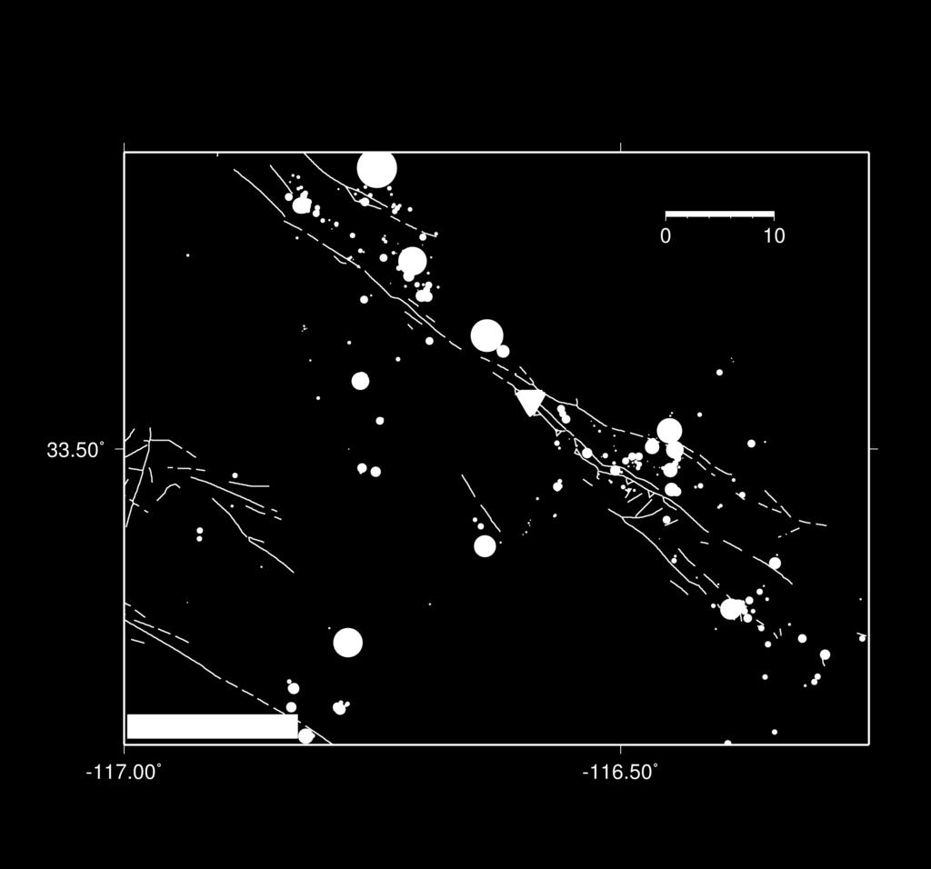
6 The SJFZ Project Deployment Map
7 PASSCAL Ad Hoc Telemetry
8 PASSCAL Ad Hoc Telemetry

9 PASSCAL Ad Hoc Telemetry


10 Trifurca(on Area

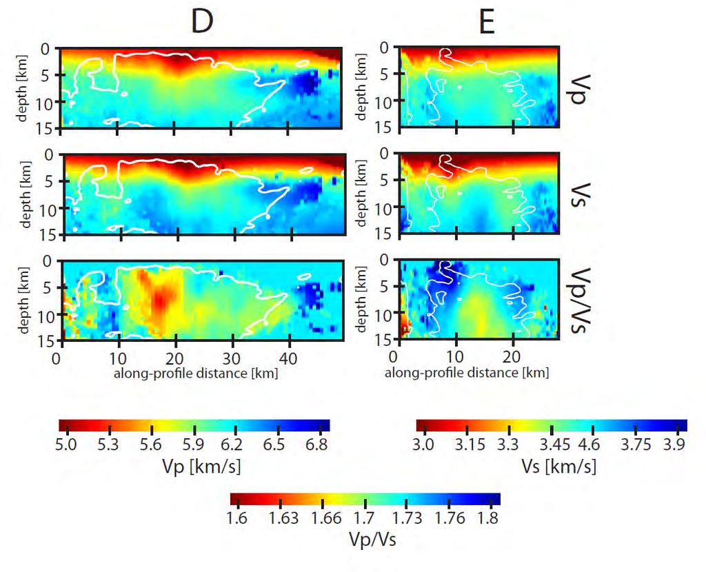
11 Trifurca(on Area 1 km Resolu(on Tomography Original loca(ons in blue! Reloca(ons in red

12 Original loca(ons in blue! Reloca(ons in red Hot Springs 1 km Resolu(on Tomography
13 3Drelocate (Alpha) - Towards a Contributed Software Package for Earthquake Location Inversions Using 3D Velocity Models Amir Allam UAF Malcolm White - UCSD
14 Basic Components generate_ttimes_fm3d Command line tool An I/O wrapper around fm3d Builds source-to-station travel-time lookup files, accounting for 3D seismic velocity structure 3Drelocate Command line tool Interfaces Antelope database with inversion algorithm in loctools3d.core_tools Can be replaced with interface to any data format
15 Basic Components loctools3d.core_tools Python module Implements location inversion algorithm Implements internal data structures to allow for interface layer to be written for any data format fm3d (N. Rawlinson) 3D wave-front tracking software Accounts for 3D seismic velocity structure Essential third-party component
16 Methodology Input P- Wave arrival time observations Brute force grid search Sub- grid inversion Output location
17 3D sdobs vs Max Az Gap
18 3D epicentral distance vs Max Az Gap
19 3D hypocentral distance vs Max Az Gap
20 3d vs 1D all data

21 3d vs 1D all data
22 3d vs 1D Max Az Gap < 200
23 3d vs 1D Max Az Gap < 200
24 3d vs 1D
25 3d vs 1D
26 3d vs 1D
27 3d vs 1D
28 3d vs 1D
29 3d vs 1D
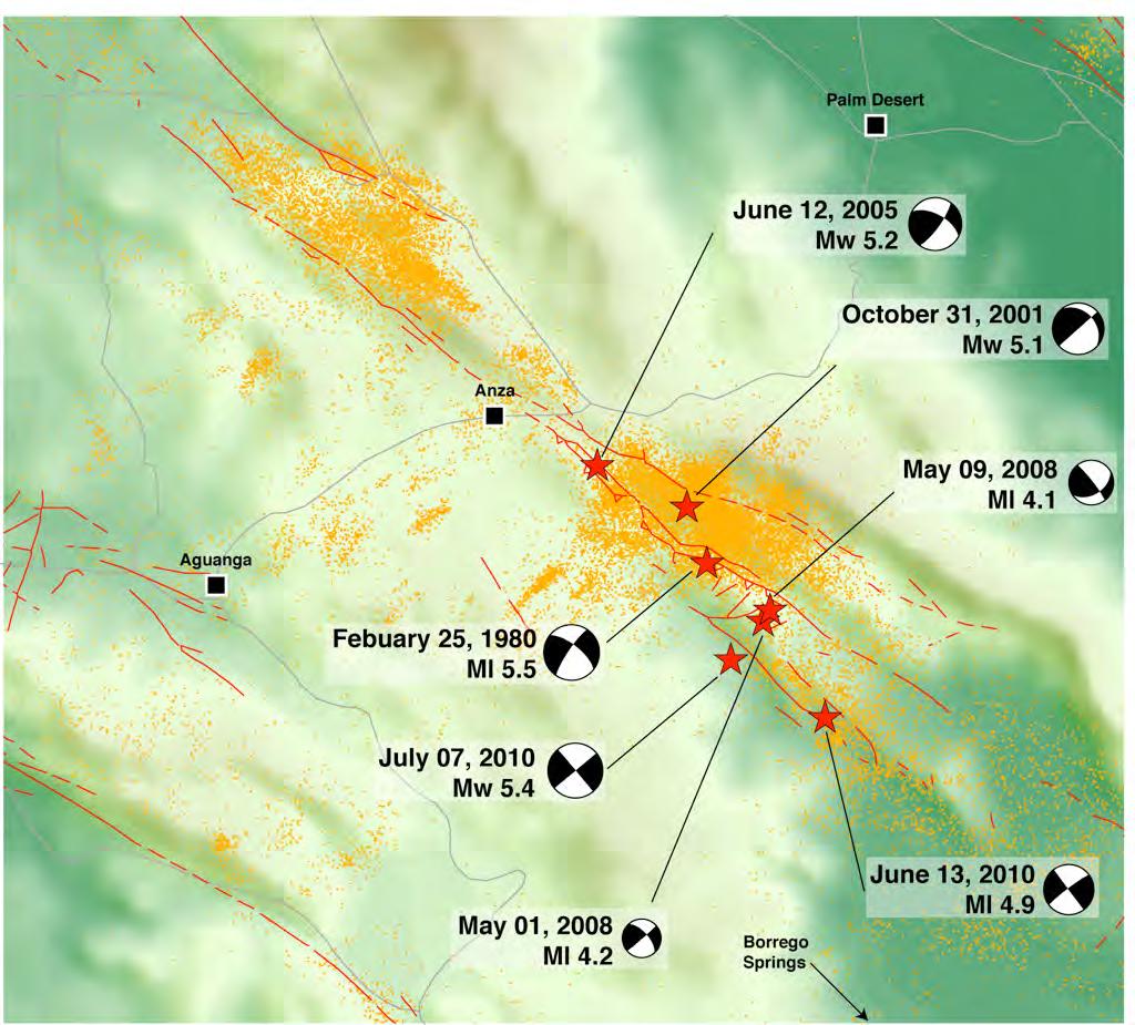
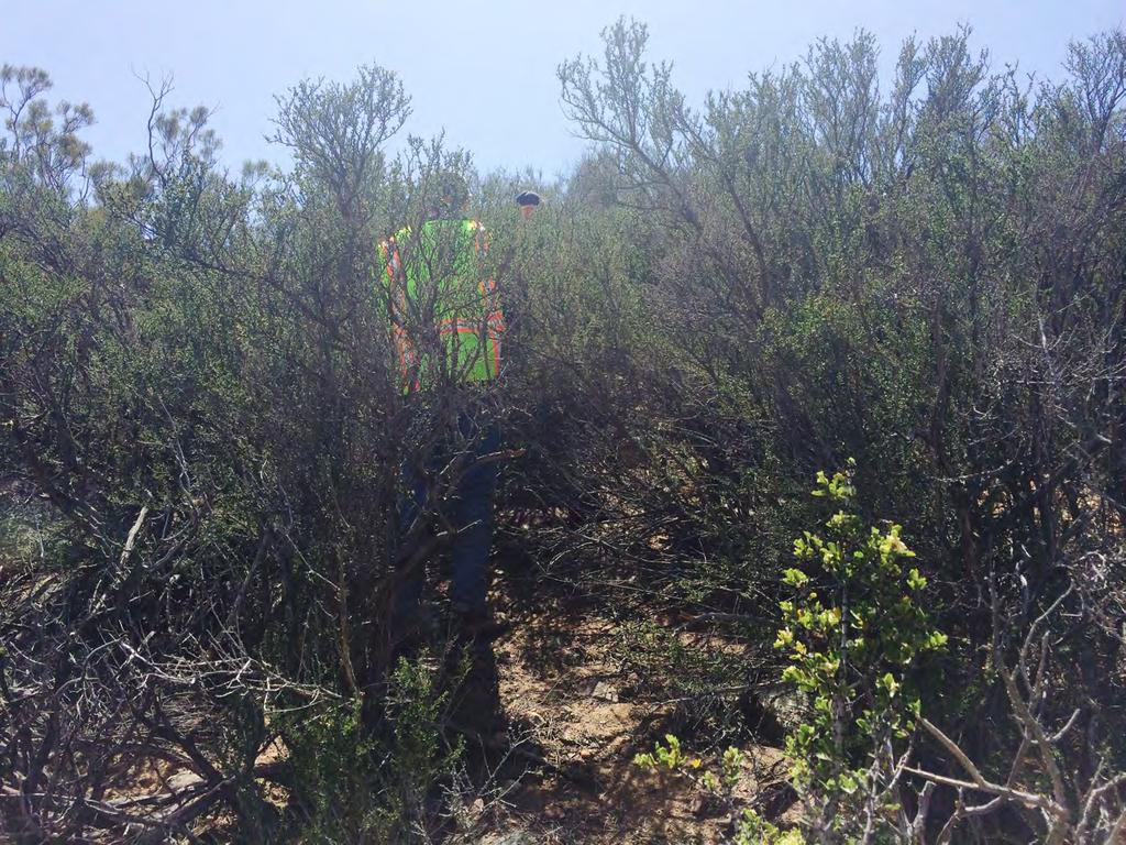
30 Sage Brush Flats Nodal Deployment SJFZ experiment 70 seismic stations 5 linear fault crossing arrays 2010 through present Sage Brush Flats Clark Fault surface trace Large amount of local seismicity Accessible
 and seismicity (red circles) of plate-boundary")
 Over 70 additional (red triangles) instruments and")
 Highly-dense rectangular array with 1108")
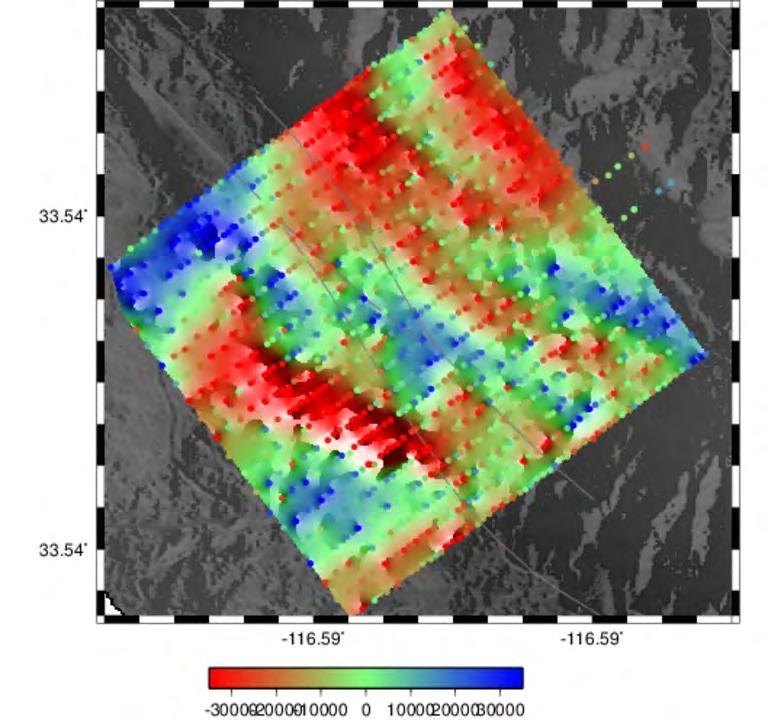
31 San Jacinto Fault Zone Dense Array (Left) Regional seismic stations (blue triangles) and seismicity (red circles) of plate-boundary region in southern California. (Bottom right) Over 70 additional (red triangles) instruments and dense linear arrays across and around the SJFZ. (Top right) Highly-dense rectangular array with 1108 vertical-component nodes. The green dots are locations of Betsy gun shots.
32 Scientific targets include: Detailed imaging of the fault zone damage on the top few 100m with noise, explosions and earthquake data Detailed imaging of deeper sections with head and trapped waves Quantifying the coherency of high frequency wave propagation near the surface Construction of very detailed local event catalog

33 Sage Brush Flats - Clark Fault

34 Sage Brush Flats - Nodal Array
35 Sage Brush Flats - Oblique View
36
37
38 Line 09 explosion
39 Potential trapped waves Line explosi
40 Line 14 explosion

41 Potential trapped waves Lin explo
42 Combined Zone of SJFZ Trapping Structure explosion
 This zone is associated with landowners home and machines (cultural noise), plus possible small sedimentary")
43 Median power (amplitude squared) recorded for duration of experiment This zone of amplified motion is associated with possible trapping structure (see next slides) This zone is associated with landowners home and machines (cultural noise), plus possible small sedimentary basin


44 Seismicity during Nodal Experiment Sage Brush Flats
45 M2 Event, Distance:10.68 km Possible fault zone trapping structure

46 Example data and correlations from the dense deployment Station R3413 Spectrogram for day 145 Time (hours) 24h data for day 145 Station R3513 Spectrogram for day h data for day 145 CC 10Hz-100Hz CC 50Hz-100Hz CC 100Hz-200Hz
47 Ambient Noise Cross-correlation Preliminary Results Line meters in length 55 elements 6-18 Hz
48 Ambient Noise Cross-correlation Surface wave velocity profile from tomographic inversion at 30 Hz

49 P wave M L 1.5 Epicentral distance 11.3 km Azimuth 120

50 P wave M L 2.3 Epicentral distance 7 km Azimuth 329
of the San Jacinto Fault Zone and detailed event catalog from spatially-dense array data
 Shallow structure s of the San Jacinto Fault Zone and detailed event catalog from spatially-dense array data Yehuda Ben-Zion, University of Southern California, with F. Vernon, Z. Ross, D. Zigone, Y. Ozakin,
Geophysical Journal International
 Geophysical Journal International Geophys. J. Int. (2015) 202, 370 380 GJI Seismology doi: 10.1093/gji/ggv142 Basic data features and results from a spatially dense seismic array on the San Jacinto fault
Rupture Dynamics of Large Earthquakes inferred from Hydroacoustic Data
 Rupture Dynamics of Large Earthquakes inferred from Hydroacoustic Data Catherine de Groot-Hedlin Scripps Institution of Oceanography University of California, San Diego Great Sumatra Earthquake (Boxing
Data Repository: Seismic and Geodetic Evidence For Extensive, Long-Lived Fault Damage Zones
 DR2009082 Data Repository: Seismic and Geodetic Evidence For Extensive, Long-Lived Fault Damage Zones Fault Zone Trapped Wave Data and Methods Fault zone trapped waves observed for 2 shots and 5 local
Ground Motion Prediction Equations in the San Jacinto Fault Zone. Significant Effects of Rupture Directivity and Fault Zone Amplification
 Ground Motion Prediction Equations in the San Jacinto Fault Zone Significant Effects of Rupture Directivity and Fault Zone Amplification I. Kurzon 1, F.L.Vernon 1, Y. Ben-Zion 2 and G. Atkinson 3 1 University
Part 2 - Engineering Characterization of Earthquakes and Seismic Hazard. Earthquake Environment
 Part 2 - Engineering Characterization of Earthquakes and Seismic Hazard Ultimately what we want is a seismic intensity measure that will allow us to quantify effect of an earthquake on a structure. S a
Effects of Surface Geology on Seismic Motion
 4 th IASPEI / IAEE International Symposium: Effects of Surface Geology on Seismic Motion August 23 26, 2011 University of California Santa Barbara TOMOGRAPHIC ESTIMATION OF SURFACE-WAVE GROUP VELOCITY
6.6 Utilizing Lightning Locations to Optimize and Quality-Control Seismic Data
 6.6 Utilizing Lightning Locations to Optimize and Quality-Control Seismic Data Jonathan Tytell* 1, Juan C. Reyes 1, Frank Vernon 1, Christopher Sloop 2, Stan Heckman 2, Amena Ali 2 1 University of California,
Magnitude 8.2 NORTHWEST OF IQUIQUE, CHILE
 An 8.2-magnitude earthquake struck off the coast of northern Chile, generating a local tsunami. The USGS reported the earthquake was centered 95 km (59 miles) northwest of Iquique at a depth of 20.1km
Fault Processes on the Anza section of the San Jacinto Fault
 Fault Processes on the nza section of the San Jacinto Fault J. Steidl (USB), M. Gladwin, R. Gwyther (SIRO ust.), F. Vernon (USD) SUMMRY We propose to instrument the nza slip gap and transition areas of
Low-velocity damaged structure of the San Andreas Fault at Parkfield from fault zone trapped waves
 GEOPHYSICAL RESEARCH LETTERS, VOL. 31, L12S06, doi:10.1029/2003gl019044, 2004 Low-velocity damaged structure of the San Andreas Fault at Parkfield from fault zone trapped waves Yong-Gang Li Department
overlie the seismogenic zone offshore Costa Rica, making the margin particularly well suited for combined land and ocean geophysical studies (Figure
 Chapter 1 Introduction Historically, highly destructive large magnitude (M w >7.0) underthrusting earthquakes nucleate along the shallow segment of subduction zone megathrust fault, and this region of
Geophysical Journal International
 Geophysical Journal International Geophys. J. Int. (2017) 210, 819 832 Advance Access publication 2017 May 5 GJI Seismology doi: 10.1093/gji/ggx191 Internal structure of the San Jacinto fault zone at Blackburn
An Improved Algorithm for Real-Time S-Wave Picking with Application to the (Augmented) ANZA Network in Southern California
 ANZA Network in Southern California") Bulletin of the Seismological Society of America, Vol. 16, No. 5, pp. 213 222, October 216, doi: 1.1785/121523 An Improved Algorithm for Real-Time S-Wave Picking with Application to the (Augmented) ANZA
Bulletin of the Seismological Society of America, Vol. 16, No. 5, pp. 213 222, October 216, doi: 1.1785/121523 An Improved Algorithm for Real-Time S-Wave Picking with Application to the (Augmented) ANZA
Topography on Earthquake Motions in Sedimentary Basins
 TRANSPORTATION RESEARCH RECORD 1411 Effects of Three-Dimensional Bedrock Topography on Earthquake Motions in Sedimentary Basins ARTHUR FRANKEL Work being done at the U.S. Geological Survey on 3-D simulations
JOINT ACCURATE TIME-FREQUENCY AND HIGH-RESOLUTION ARRAY ANALYSIS, A TOOL FOR SITE EFFECTS ESTIMATION?
 Third International Symposium on the Effects of Surface Geology on Seismic Motion Grenoble, France, 30 August - 1 September 2006 Paper Number: 152 JOINT ACCURATE TIME-FREQUENCY AND HIGH-RESOLUTION ARRAY
Seismogeodesy for rapid earthquake and tsunami characterization
 Seismogeodesy for rapid earthquake and tsunami characterization Yehuda Bock Scripps Orbit and Permanent Array Center Scripps Institution of Oceanography READI & NOAA-NASA Tsunami Early Warning Projects
29th Monitoring Research Review: Ground-Based Nuclear Explosion Monitoring Technologies
 IMPROVING MAGNITUDE DETECTION THRESHOLDS USING MULTI-STATION, MULTI-EVENT, AND MULTI-PHASE METHODS David Schaff and Felix Waldhauser Lamont-Doherty Earth Observatory, Columbia University Sponsored by Air
3D VISCO-ELASTIC WAVE PROPAGATION IN THE BORREGO VALLEY, CALIFORNIA
 3D VISCO-ELASTIC WAVE PROPAGATION IN THE BORREGO VALLEY, CALIFORNIA Kim B OLSEN 1, Robert L NIGBOR 2 And Takaaki KONNO 3 SUMMARY We have simulated 2-Hz wave propagation in a three-dimensional model of
2008 Monitoring Research Review: Ground-Based Nuclear Explosion Monitoring Technologies
 STRUCTURE OF THE KOREAN PENINSULA FROM WAVEFORM TRAVEL-TIME ANALYSIS Roland Gritto 1, Jacob E. Siegel 1, and Winston W. Chan 2 Array Information Technology 1 and Harris Corporation 2 Sponsored by Air Force
Determining the Earthquake Epicenter: Japan
 Practice Name: Hour: Determining the Earthquake Epicenter: Japan Measuring the S-P interval There are hundreds of seismic data recording stations throughout the United States and the rest of the world.
Observations of Atmospheric Phenomena from USArray and ANZA Observing Systems
 Observations of Atmospheric Phenomena from USArray and ANZA Observing Systems Text Frank Vernon Antelope User Group Meeting Muscat, Oman 2-4 March 2013 Collaboration with the High Performance Wireless
Determining SAFOD area microearthquake locations solely with the Pilot Hole seismic array data
 GEOPHYSICAL RESEARCH LETTERS, VOL. 31, L12S10, doi:10.1029/2003gl019403, 2004 Determining SAFOD area microearthquake locations solely with the Pilot Hole seismic array data Volker Oye NORSAR, Kjeller,
A systematic measurement of shear wave anisotropy in southern California Report for SCEC Award #15081 Submitted March 15, 2016
 A systematic measurement of shear wave anisotropy in southern California Report for SCEC Award #15081 Submitted March 15, 2016 Investigators: Zhigang Peng (Georgia Tech) I. Project Overview... i A. Abstract...
Earthquakes and Seismotectonics Chapter 5
 Earthquakes and Seismotectonics Chapter 5 What Creates Earthquakes? The term Earthquake is ambiguous: Applies to general shaking of the ground and to the source of the shaking We will talk about both,
Final Report for DOEI Project: Bottom Interaction in Long Range Acoustic Propagation
 Final Report for DOEI Project: Bottom Interaction in Long Range Acoustic Propagation Ralph A. Stephen Woods Hole Oceanographic Institution 360 Woods Hole Road (MS#24) Woods Hole, MA 02543 phone: (508)
29th Monitoring Research Review: Ground-Based Nuclear Explosion Monitoring Technologies ADVANCED WAVEFORM SIMULATION FOR SEISMIC MONITORING EVENTS
 ABSTRACT ADVANCED WAVEFORM SIMULATION FOR SEISMIC MONITORING EVENTS Don V. Helmberger 1, Jeroen Tromp 1, and Arthur J. Rodgers 2 California Institute of Technology 1 and Lawrence Livermore National Laboratory
APPLICATION OF A PASSIVE TOMOGRAPHY METHOD AND CORRELATION WITH ACTIVE SEISMIC OBSERVATIONS IN THE KYPARISSIAKOS GULF, SOUTHWESTERN HELLENIC ARC
 APPLICATION OF A PASSIVE TOMOGRAPHY METHOD AND CORRELATION WITH ACTIVE SEISMIC OBSERVATIONS IN THE KYPARISSIAKOS GULF, SOUTHWESTERN HELLENIC ARC Tsambas A. 1, Fasoulaka Ch. 2, Papoulia J. 1, Makris J.
Plate Boundary Observatory Working Group for the Central and Northern San Andreas Fault System PBO-WG-CNSA
 Plate Boundary Observatory Working Group for the Central and Northern San Andreas Fault System PBO-WG-CNSA Introduction Our proposal focuses on the San Andreas fault system in central and northern California.
External Grant Award Number 04HQGR0058 IMPROVED THREE-DIMENSIONAL VELOCITY MODELS AND EARTHQUAKE LOCATIONS FOR CALIFORNIA
 External Grant Award Number 04HQGR0058 IMPROVED THREE-DIMENSIONAL VELOCITY MODELS AND EARTHQUAKE LOCATIONS FOR CALIFORNIA Clifford H. Thurber University of Wisconsin-Madison 1215 W. Dayton St. Madison,
Ocean Bottom Seismometer Augmentation of the NPAL Philippine Sea Experiment
 DISTRIBUTION STATEMENT A. Approved for public release; distribution is unlimited. Ocean Bottom Seismometer Augmentation of the NPAL 2010-2011 Philippine Sea Experiment Ralph A. Stephen Woods Hole Oceanographic
Tomographic imaging of P wave velocity structure beneath the region around Beijing
 403 Doi: 10.1007/s11589-009-0403-9 Tomographic imaging of P wave velocity structure beneath the region around Beijing Zhifeng Ding Xiaofeng Zhou Yan Wu Guiyin Li and Hong Zhang Institute of Geophysics,
Local-scale cross-correlation of seismic noise from the Calico fault experiment
 DOI 10.1007/s11589-014-0074-z RESEARCH PAPER Local-scale cross-correlation of seismic noise from the Calico fault experiment Jian Zhang Peter Gerstoft Received: 27 November 2013 / Accepted: 28 February
A BROADBAND SEISMIC EXPERIMENT IN YUNNAN, SOUTHWEST CHINA. Sponsored by Defense Threat Reduction Agency. Contract No.
 A BROADBAND SEISMIC EXPERIMENT IN YUNNAN, SOUTHWEST CHINA Wenjie Jiao, 1 Winston Chan, 1 and Chunyong Wang 2 Multimax Inc., 1 Institute of Geophysics, China Seismological Bureau 2 Sponsored by Defense
THREE-DIMENSIONAL FINITE DIFFERENCE SIMULATION OF LONG-PERIOD GROUND MOTION IN THE KANTO PLAIN, JAPAN
 THREE-DIMENSIONAL FINITE DIFFERENCE SIMULATION OF LONG-PERIOD GROUND MOTION IN THE KANTO PLAIN, JAPAN Nobuyuki YAMADA 1 And Hiroaki YAMANAKA 2 SUMMARY This study tried to simulate the long-period earthquake
Earthquake patterns in the Flinders Ranges - Temporary network , preliminary results
 Earthquake patterns in the Flinders Ranges - Temporary network 2003-2006, preliminary results Objectives David Love 1, Phil Cummins 2, Natalie Balfour 3 1 Primary Industries and Resources South Australia
BROADBAND STRONG MOTION SIMULATION OF THE 2004 NIIGATA- KEN CHUETSU EARTHQUAKE: SOURCE AND SITE EFFECTS
 Third International Symposium on the Effects of Surface Geology on Seismic Motion Grenoble, France, 30 August - 1 September 2006 Paper Number: 105 BROADBAND STRONG MOTION SIMULATION OF THE 2004 NIIGATA-
SUPPLEMENTARY INFORMATION
 doi:10.1038/nature11492 Figure S1 Short-period Seismic Energy Release Pattern Imaged by F-net. (a) Locations of broadband seismograph stations in Japanese F-net used for the 0.5-2.0 Hz P wave back-projection
Online material: Updated 3-D tomography model and plotting script with examples
 Model Update January 2010: Upper Mantle Heterogeneity beneath North merica from Traveltime Tomography with Global and usarray Transportable rray Data Scott urdick, Robert D. van der Hilst, Frank L. Vernon,
27th Seismic Research Review: Ground-Based Nuclear Explosion Monitoring Technologies
 EVALUATION OF CROSS-CORRELATION METHODS ON A MASSIVE SCALE FOR ACCURATE RELOCATION OF SEISMIC EVENTS Won-Young Kim, Paul G. Richards, David P. Schaff, Felix Waldhauser, and Jian Zhang Lamont-Doherty Earth
Analysis of the 29th May 2008 Ölfus earthquake and aftershock sequence using three-component t processing on ICEARRAY
 Analysis of the 29th May 2008 Ölfus earthquake and aftershock sequence using three-component t processing on ICEARRAY Benedikt Halldórsson Steven J. Gibbons International Symposium on Strong-motion Earthquake
Piñon Flat Observatory Field Trip, November 2015
 Piñon Flat Observatory Field Trip, November 2015 33.75 33.50 B C D E F G PFO H 33.25 33.00 A SIO 32.75-117.25-117.00-116.75-116.50-116.25-116.00 -2- Road Log for Trip to PFO (see map, above) Map Distance
S e i s m i c W a v e s
 Project Report S e i s m i c W a v e s PORTLAND STATE UNIVERSITY PHYSICS 213 SPRING TERM 2005 Instructor: Dr. Andres La Rosa Student Name: Prisciliano Peralta-Ramirez Table Of Contents 1. Cover Sheet 2.
Effects of Surface Geology on Seismic Motion
 4 th IASPEI / IAEE International Symposium: Effects of Surface Geology on Seismic Motion August 23 26, 2011 University of California Santa Barbara VELOCITY STRUCTURE INVERSIONS FROM HORIZONTAL TO VERTICAL
Internal Layers of the Earth
 Lecture #4 notes Geology 3950, Spring 2006; CR Stern Seismic waves, earthquake magnitudes and location, and internal earth structure (pages 28-95 in the 4 th edition and 28-32 and 50-106 in the 5 th edition)
Lab 6: Earthquake Focal Mechanisms (35 points)
") Lab 6: Earthquake Focal Mechanisms (35 points) Group Exercise 1. Drawing Nodal Planes (8 pts) The outline map below labeled Figure 4.60a shows the positions of two earthquakes recorded on the Mid-Atlantic
Lab 6: Earthquake Focal Mechanisms (35 points) Group Exercise 1. Drawing Nodal Planes (8 pts) The outline map below labeled Figure 4.60a shows the positions of two earthquakes recorded on the Mid-Atlantic
Peter Shearer 1, Robin Matoza 1, Cecily Wolfe 2, Guoqing Lin 3, & Paul Okubo 4
 Characterizing fault zones and volcanic conduits at Kilauea and Mauna Loa volcanoes by large-scale mapping of earthquake stress drops and high precision relocations Peter Shearer 1, Robin Matoza 1, Cecily
CHAPTER 1 BASIC SEISMOLOGY AND EARTHQUAKE TERMINOLGY. Earth Formation Plate Tectonics Sources of Earthquakes...
 CHAPTER 1 BASIC SEISMOLOGY AND EARTHQUAKE TERMINOLGY Earth Formation... 1-2 Plate Tectonics... 1-2 Sources of Earthquakes... 1-3 Earth Faults... 1-4 Fault Creep... 1-5 California Faults... 1-6 Earthquake
Supporting Online Material for
 www.sciencemag.org/cgi/content/full/1131692/dc1 Supporting Online Material for Localized Temporal Change of the Earth s Inner Core Boundary This PDF file includes: Materials and Methods Figs. S1 to S3
Chapter 3 Minimum 1-D Velocity Model: Using joint determination of hypocenters and velocity 3.1 Introduction
 Chapter 3 Minimum 1-D Velocity Model: Using joint determination of hypocenters and velocity 3.1 Introduction This chapter deals with the estimation of a new 1-D velocity model in the Kumaon- Garhwal Himalaya
27th Seismic Research Review: Ground-Based Nuclear Explosion Monitoring Technologies
 MODEL-BASED HYDROACOUSTIC BLOCKAGE ASSESSMENT AND DEVELOPMENT OF AN EXPLOSIVE SOURCE DATABASE Eric Matzel, Abe L. Ramirez, and Philip E. Harben Lawrence Livermore National Laboratory Sponsored by National
Borehole Array observation system operated by Tono Research Institute of Earthquake Science and Some Interesting Result
 Borehole Array observation system operated by Tono Research Institute of Earthquake Science and Some Interesting Result Yasuhiro ASAI Tono Research Institute of Earthquake Science (TRIES) Association for
FULL MOMENT TENSOR ANALYSIS USING FIRST MOTION DATA AT THE GEYSERS GEOTHERMAL FIELD
 PROCEEDINGS, Thirty-Eighth Workshop on Geothermal Reservoir Engineering Stanford University, Stanford, California, February 11-13, 2013 SGP-TR-198 FULL MOMENT TENSOR ANALYSIS USING FIRST MOTION DATA AT
29th Monitoring Research Review: Ground-Based Nuclear Explosion Monitoring Technologies
 ANALYSIS AND SIMULATION OF THREE-DIMENSIONAL SCATTERING DUE TO HETEROGENEOUS CRUSTAL STRUCTURE AND SURFACE TOPOGRAPHY ON REGIONAL PHASES; MAGNITUDE AND DISCRIMINATION Arben Pitarka 1, Don V. Helmberger
29th Monitoring Research Review: Ground-Based Nuclear Explosion Monitoring Technologies MODELING P WAVE MULTIPATHING IN SOUTHEAST ASIA
 MODELING P WAVE MULTIPATHING IN SOUTHEAST ASIA Ali Fatehi and Keith D. Koper Saint Louis University Sponsored by the Air Force Research Laboratory ABSTRACT Contract No. FA8718-06-C-0003 We have used data
Velocity-Interface Structure of the Southwestern Ryukyu Subduction Zone from EW OBS/MCS Data
 Marine Geophysical Researches 22: 265-287, 2001. 2002 Kluwer Academic Publishers. Printed in the Netherlands. Velocity-Interface Structure of the Southwestern Ryukyu Subduction Zone from EW9509-1 OBS/MCS
Principles of the Global Positioning System Lecture 24
 12.540 Principles of the Global Positioning System Lecture 24 Prof. Thomas Herring http://geoweb.mit.edu/~tah/12.540 OVERVIEW Examination of results from Earthscope Reference frame definition: SNARF High-rate
Widespread Ground Motion Distribution Caused by Rupture Directivity during the 2015 Gorkha, Nepal Earthquake
 Widespread Ground Motion Distribution Caused by Rupture Directivity during the 2015 Gorkha, Nepal Earthquake Kazuki Koketsu 1, Hiroe Miyake 2, Srinagesh Davuluri 3 and Soma Nath Sapkota 4 1. Corresponding
JCR (2 ), JGR- (1 ) (4 ) 11, EPSL GRL BSSA
, JGR- (1 ) (4 ) 11, EPSL GRL BSSA") Dun Wang ( ) In collaboration with: Hitoshi Kawakatsu, Jim Mori, Kazuki Koketsu, Takuto Maeda, Hiroshi Tsuroka, Jiancang Zhunag, Lihua Fang, and Qiang Yao School of Geosciences, China University of Geosciences
Dun Wang ( ) In collaboration with: Hitoshi Kawakatsu, Jim Mori, Kazuki Koketsu, Takuto Maeda, Hiroshi Tsuroka, Jiancang Zhunag, Lihua Fang, and Qiang Yao School of Geosciences, China University of Geosciences
28th Seismic Research Review: Ground-Based Nuclear Explosion Monitoring Technologies
 GROUND TRUTH HYPOCENTERS AND 3D CRUSTAL VELOCITY STRUCTURE IN CENTRAL ASIA FROM IN-COUNTRY NETWORKS Thomas de la Torre 1, Gaspar Monsalve-Mejia 1, Anne F. Sheehan 1, Charlotte Rowe 2, and Michael Begnaud
FloatSeis Technologies for Ultra-Deep Imaging Seismic Surveys
 FloatSeis Technologies for Ultra-Deep Imaging Seismic Surveys 25 th January, 2018 Aleksandr Nikitin a.nikitin@gwl-geo.com Geology Without Limits Overview 2011-2016 GWL Acquired over 43000 km 2D seismic
29th Monitoring Research Review: Ground-Based Nuclear Explosion Monitoring Technologies
 TRANSITION ZONE WAVE PROPAGATION: CHARACTERIZING TRAVEL-TIME AND AMPLITUDE INFORMATION Peter M. Shearer and Jesse F. Lawrence University of California San Diego, Institute of Geophysics and Planetary Physics
Structural Cause of Missed Eruption in the Lunayyir Basaltic
 GSA DATA REPOSITORY 2015140 Supplementary information for the paper Structural Cause of Missed Eruption in the Lunayyir Basaltic Field (Saudi Arabia) in 2009 Koulakov, I., El Khrepy, S., Al-Arifi, N.,
Long-period ground motion characterization by cross wavelet transform
 Long-period ground motion characterization by cross wavelet transform *Tsoggerel Tsamba 1) and Masato Motosaka 2) 1), 2) International Research Institute of Disaster Science, Tohoku University, Sendai980-8579,Japan
Imaging sharp lateral velocity gradients using scattered waves on dense arrays: faults and basin edges
 2017 SCEC Proposal Report #17133 Imaging sharp lateral velocity gradients using scattered waves on dense arrays: faults and basin edges Principal Investigator Zhongwen Zhan Seismological Laboratory, California
SONGS Seismic Research Projects
 SONGS Seismic Research Projects Energy Division Independent Peer Review Group September 21, 2012 Agenda Background Overview Project Support Permits, Approvals, and Reviews Schedule Use of Advanced Technologies
Lab 9: Satellite Geodesy (35 points)
") Lab 9: Satellite Geodesy (35 points) Here you will work with GPS Time Series data to explore plate motion and deformation in California. This lab modifies an exercise found here: http://www.unavco.org:8080/cws/pbonucleus/draftresources/sanandreas/
Lab 9: Satellite Geodesy (35 points) Here you will work with GPS Time Series data to explore plate motion and deformation in California. This lab modifies an exercise found here: http://www.unavco.org:8080/cws/pbonucleus/draftresources/sanandreas/
Geo736: Seismicity and California s Active Faults Introduction
 Geo736: Seismicity and California s Active Faults Course Notes: S. G. Wesnousky Spring 2018 Introduction California sits on the boundary of the Pacific - North American plate boundary (Figure 1). Relative
GPS Strain & Earthquakes Unit 5: 2014 South Napa earthquake GPS strain analysis student exercise
 GPS Strain & Earthquakes Unit 5: 2014 South Napa earthquake GPS strain analysis student exercise Strain Analysis Introduction Name: The earthquake cycle can be viewed as a process of slow strain accumulation
2008 Monitoring Research Review: Ground-Based Nuclear Explosion Monitoring Technologies
 STRUCTURE OF THE KOREAN PENINSULA FROM WAVEFORM TRAVEL-TIME ANALYSIS Roland Gritto 1, Jacob E. Siegel 1, and Winston W. Chan 2 Array Information Technology 1 and Harris Corporation 2 Sponsored by Air Force
Seismic Recording Station AZ_PFO Summary Report
 Seismic Recording Station AZ_PFO Summary Report Thank you for hosting station AZ_PFO on your property. We hope that you find the enclosed report interesting. Your station is one of the 2000 USArray seismic
Borehole Seismic Monitoring of Injected CO 2 at the Frio Site
 Borehole Seismic Monitoring of Injected CO 2 at the Frio Site * Daley, T M (tmdaley@lbl.gov), Lawrence Berkeley National Lab., 1 Cyclotron Rd, Berkeley, CA 94720 Myer, L (lrmyer@lbl.gov), Lawrence Berkeley
crustal volume of the swarm. This initiated interest and concern that another
 3. Earthquae locations Data from permanent seismic networs located the 2001 Enola mainshoc within the crustal volume of the 1982-84 swarm. This initiated interest and concern that another 1982-lie sequence
Three Fs of earthquakes: forces, faults, and friction. Slow accumulation and rapid release of elastic energy.
 Earthquake Machine Stick-slip: Elastic Rebound Theory Jerky motions on faults produce EQs Three Fs of earthquakes: forces, faults, and friction. Slow accumulation and rapid release of elastic energy. Three
Empirical Green s Function Analysis of the Wells, Nevada, Earthquake Source
 Nevada Bureau of Mines and Geology Special Publication 36 Empirical Green s Function Analysis of the Wells, Nevada, Earthquake Source by Mendoza, C. 1 and Hartzell S. 2 1 Centro de Geociencias, Universidad
RELOCATION OF THE MACHAZE AND LACERDA EARTHQUAKES IN MOZAMBIQUE AND THE RUPTURE PROCESS OF THE 2006 Mw7.0 MACHAZE EARTHQUAKE
 RELOCATION OF THE MACHAZE AND LACERDA EARTHQUAKES IN MOZAMBIQUE AND THE RUPTURE PROCESS OF THE 2006 Mw7.0 MACHAZE EARTHQUAKE Paulino C. FEITIO* Supervisors: Nobuo HURUKAWA** MEE07165 Toshiaki YOKOI** ABSTRACT
Seismic Observation and Seismicity of Uganda
 (Uganda, Mr. Nyago Joseph, 2012-2013S) Seismic Observation and Seismicity of Uganda 1. Seismic observation in Uganda In 1989, UNESCO and the International Programs in Physical Sciences (IPPS) donated four
Long-period Ground Motion Characteristics of the Osaka Sedimentary Basin during the 2011 Great Tohoku Earthquake
 Long-period Ground Motion Characteristics of the Osaka Sedimentary Basin during the 2011 Great Tohoku Earthquake K. Sato, K. Asano & T. Iwata Disaster Prevention Research Institute, Kyoto University, Japan
Arthur Frankel, William Stephenson, David Carver, Jack Odum, Robert Williams, and Susan Rhea U.S. Geological Survey
 Probabilistic Seismic Hazard Maps for Seattle: 3D Sedimentary Basin Effects, Nonlinear Site Response, and Uncertainties from Random Velocity Variations Arthur Frankel, William Stephenson, David Carver,
Some aspects of seismic tomography
 Some aspects of seismic tomography Peter Shearer IGPP/SIO/U.C. San Diego September 7, 2009 Earthquake Research Institute Part 1: Global Tomography P velocity perturbations 200 km 1000 km 2700 km MIT 2006
Magnitude 6.9 GULF OF CALIFORNIA
 A pair of strong earthquakes struck off the coast of Mexico early Thursday only minutes apart. The magnitude 6.9 and 6.2 were centered about 85 miles northeast of Guerrero Negro in the Mexican state of
Notes on Comparing the Nano-Resolution Depth Sensor to the Co-located Ocean Bottom Seismometer at MARS
 Notes on Comparing the Nano-Resolution Depth Sensor to the Co-located Ocean Bottom Seismometer at MARS Elena Tolkova, Theo Schaad 1 1 Paroscientific, Inc., and Quartz Seismic Sensors, Inc. October 15,
Synthetic Seismogram A Tool to Calibrate PP & PS Seismic Data
 P-475 Summary Synthetic Seismogram A Tool to Calibrate PP & PS Seismic P. Sugadha*, M. K. Jain, M. Singh, ONGC Conventional P wave technology will not meet all the requirements of the industry. Hence,
The Coso Geothermal Area: A Laboratory for Advanced MEQ Studies for Geothermal Monitoring
 The Coso Geothermal Area: A Laboratory for Advanced MEQ Studies for Geothermal Monitoring Bruce R. Julian U. S. Geological Survey, Menlo Park, CA 94025 USA julian@usgs.gov Gillian R. Foulger Dept. Earth
Fault Specific, Dynamic Rupture Scenarios for Strong Ground Motion Prediction
 Fault Specific, Dynamic Rupture Scenarios for Strong Ground Motion Prediction H. Sekiguchi Disaster Prevention Research Institute, Kyoto University, Japan Blank Line 9 pt Y. Kase Active Fault and Earthquake
P Wave Reflection and Refraction and SH Wave Refraction Data Processing in the Mooring, TN Area
 P Wave Reflection and Refraction and SH Wave Refraction Data Processing in the Mooring, TN Area Abstract: Author: Duayne Rieger Home Institution: Slippery Rock University of Pennsylvania REU Institution:
Southern California ground motion envelopes over ranges of magnitudes, distances, and site conditions
 55 Chapter 3 Average properties of Southern California ground motion envelopes over ranges of magnitudes, distances, and site conditions In this chapter, I use the envelope attenuation relationships derived
Walkaway Seismic Experiments: Stewart Gulch, Boise, Idaho
 Walkaway Seismic Experiments: Stewart Gulch, Boise, Idaho Lee M. Liberty Center for Geophysical Investigation of the Shallow Subsurface Boise State University Boise, Idaho 1. Summary CGISS conducted walkaway
Blue and Fin Whale Habitat Modeling from Long-Term Year-Round Passive Acoustic Data from the Southern California Bight
 DISTRIBUTION STATEMENT A. Approved for public release; distribution is unlimited. Blue and Fin Whale Habitat Modeling from Long-Term Year-Round Passive Acoustic Data from the Southern California Bight
Applications of finite-difference modelling to coalscale seismic exploration
 Applications of finite-difference modelling to coalscale seismic exploration Shaun Strong 1,2, Troy Peters 1 1. Velseis Pty Ltd 2 University of Queensland Introduction Geological environments with significant
arxiv: v1 [physics.geo-ph] 31 Dec 2013
![arxiv: v1 [physics.geo-ph] 31 Dec 2013](/thumbs/95/125064092.jpg "arxiv: v1 [physics.geo-ph] 31 Dec 2013") Comparing the Nano-Resolution Depth Sensor to the Co-located Ocean Bottom Seismometer at MARS Elena Tolkova 1, Theo Schaad 2 1 NorthWest Research Associates 2 Paroscientific, Inc., and Quartz Seismic Sensors,
Comparing the Nano-Resolution Depth Sensor to the Co-located Ocean Bottom Seismometer at MARS Elena Tolkova 1, Theo Schaad 2 1 NorthWest Research Associates 2 Paroscientific, Inc., and Quartz Seismic Sensors,
THE USE OF INPUT ENERGY FOR SEISMIC HAZARD ASSESSMENT WITH DIFFERENT DUCTILITY LEVEL
 th World Conference on Earthquake Engineering Vancouver, B.C., Canada August -6, Paper No. 8 THE USE OF INPUT ENERGY FOR SEISMIC HAZARD ASSESSMENT WITH DIFFERENT DUCTILITY LEVEL Mao-Sheng GONG And Li-Li
Investigation of long period amplifications in the Greater Bangkok basin by microtremor observations
 Proceedings of the Tenth Pacific Conference on Earthquake Engineering Building an Earthquake-Resilient Pacific 6-8 November 2015, Sydney, Australia Investigation of long period amplifications in the Greater
3.3. Waveform Cross-Correlation, Earthquake Locations and HYPODD
 3.3. Waveform Cross-Correlation, Earthquake Locations and HYPODD 3.3.1 Method More accurate relative earthquake locations depend on more precise relative phase arrival observations so I exploit the similarity
27th Seismic Research Review: Ground-Based Nuclear Explosion Monitoring Technologies
 ADDITIONAL INFRASONIC STUDIES OF EARTHQUAKES AND MINING BLASTS DISCRIMINATION Douglas O. ReVelle Los Alamos National Laboratory Sponsored by National Nuclear Security Administration Office of Nonproliferation
[S06 ] Shear Wave Resonances in Sediments on the Deep Sea Floor
![[S06 ] Shear Wave Resonances in Sediments on the Deep Sea Floor](/thumbs/82/85496146.jpg "[S06 ] Shear Wave Resonances in Sediments on the Deep Sea Floor") page 1 of 16 [S06 ] Shear Wave Resonances in Sediments on the Deep Sea Floor I. Zeldenrust * and R. A. Stephen ** * Department of Geology Free University, Amsterdam ** Department of Geology and Geophysics
page 1 of 16 [S06 ] Shear Wave Resonances in Sediments on the Deep Sea Floor I. Zeldenrust * and R. A. Stephen ** * Department of Geology Free University, Amsterdam ** Department of Geology and Geophysics
SEISMIC SURVEYS FOR IMAGING THE REGOLITH
 SEISMIC SURVEYS FOR IMAGING THE REGOLITH Barry Drummond Geoscience Australia. PO Box 378, Canberra, ACT 2601. E-mail: barry.drummond@ga.gov.au 1. INTRODUCTION Seismic reflection and refraction imaging
Seismological laboratory in Agua Negra tunnel
 Instituto Geofísico Sismológico Volponi Universidad Nacional de San Juan Seismological laboratory in Agua Negra tunnel Buenos Aires, Abril 2011 Why a Seismological laboratory in Agua Negra tunnel? Earthquake
29th Monitoring Research Review: Ground-Based Nuclear Explosion Monitoring Technologies
 FINITE DIFFERENCE MODELING OF INFRASOUND PROPAGATION TO LOCAL AND REGIONAL DISTANCES Catherine de Groot-Hedlin Scripps Institution of Oceanography, University of California at San Diego Sponsored by Army
Characterization of Induced Seismicity in a Petroleum Reservoir: A Case Study
 Characterization of Induced Seismicity in a Petroleum Reservoir: A Case Study Edmond Sze, M. Nafi Toksöz, and Daniel R. Burns Earth Resources Laboratory Dept. of Earth, Atmospheric and Planetary Sciences