Observations of Atmospheric Phenomena from USArray and ANZA Observing Systems
|
|
|
- Silvia Hall
- 5 years ago
- Views:
Transcription

1 Observations of Atmospheric Phenomena from USArray and ANZA Observing Systems Text Frank Vernon Antelope User Group Meeting Muscat, Oman 2-4 March 2013
2 Collaboration with the High Performance Wireless Research and Education Network (HPWREN) Research Education Public Safety Weather data (real time) Cameras! Array Network Facility The Array Network Facility (ANF) at UC San Diego Specializes in real-time data acquisition, quality control, dissemination of seismic and met data Two main projects: USArray Transportable Array Network (anf.ucsd.edu) Anza Network UCSD operated seismic network in SoCal


3 Acknowledgements EarthScope is funded by the National Science Foundation. EarthScope is being constructed, operated, and maintained as a collaborative effort with UNAVCO, IRIS, and Stanford University, with contributions from the US Geological Survey, NASA and several other national and international organizations.
4 Seismic Noise Multiple sources of seismic noise: Anthropogenic Planes Trains Automobiles Natural Wildlife Rainfall Hail Wind Thunder Storms Bolides (meteorites)


5 IMS Infrasound arrays and USArray TA in June, rocket motor detonations from May to September


6 IMS Infrasound arrays and USArray TA in June, 2007
7
8 Oregon Bolide A bolide burst above NE Oregon at 05:30 AM local time on Feb 19, 2008 The event was recorded by 4 infrasound arrays and several hundred seismic stations in the USArray and regional networks The seismic stations reveal how infrasound signals vary with range and azimuth Celerity (horizontal distance traveled/travel time) vs range plots may shed light on propagation paths and provide useful information about atmospheric structure


9 1700 km 297 km Seismic stns in red recording from I56US 800 km 1350 km I57US

10 Sample record section to west of event Z components Bp Hz
11 Just I56US Array Celerity
12 TA + Array Celerity
13 Acoustic branches Hedlin et al 2010


14 Pressure Sensor Response Overlapping pass-bands provides continuous coverage from DC to 20 Hz Setra Barometer EP - LDO, EP - BDO NCPA Infrasound Microphone EP - LDF, EP - BDF MEMS Barometer EP - LDM 8 8


15 Basic Description Sensor: 3 component Broadband seismometer & auxiliary sensors Datalogger & local data storage Power & data telemetry TA Station 345A, MS 6
16 Implementation of Atmospheric Pressure Sensors


17 Pressure Observations Pressure and infrasound at every TA station Sampled at 40 samples per second Pressure fluctuations from DC to 20 Hz Multiple applications Noise induced on vertical and horizontal seismic channels Meso-scale atmosphere variation Acoustic energy propagating in the atmosphere Acoustic seismic coupling MesoWest is accessing data via web services


18 Atmospheric Acoustic Transportable Array TA-TPFO One port Bag of gravel Both tubes inside gravel IMS57 70M aperture 25 element array Adjacent arrays near TPFO 2 minute trace length
19 Basic Observation Pressure observations show strong correlation to seismic data LDM - pressure LHE- seismic Pressure Seismic Coherence
20 Pressure-Ground motion Pressure-seismic coherence is well observed for both vertical and horizontal components Multiple studies have used the pressure signal as a means of denoising the seismic data Vertical component At long periods (e.g., 2-4 mhz) verticals have a gravity contribution from the mass of air and deformation effect (Zürn & Widmer, 1995) Horizontal components Pressure fluctuations introduce multiple tilt effects (Sorrells, 1971) Traveling Wave Model Depends on pressure variation in time and space Local Deformation Model Depends on time variation of pressure, not spatial variation Assumed to be specific to local site - collective response of sensor, vault, local site conditions,... Like pushing on a three-legged stool with one weak leg the result of pressure fluctuations from above will produce tilt in the same direction
21 Method Use 30 day time series, bandpass filtered 2,000 s 100 s Sliding ~3 hour window, 50% overlap Compute coherence in band around 1,000 s Rotate horizontals to maximize coherence Process several months of data ~450 coherence estimates per station per month Plow through noise, earthquakes, etc. Focus on spatial characteristics of pressure-seismic coherence, not amplitude relationship (e.g., admittance) poor C28A best 200 Aug 2010
22 Coherent Behavior at Neighboring Stations Preferred orientation stable, but changes with time Neighboring stations C28A-D28A (70 km) behave similarly Aug 2010 Sept 2010 Oct 2010 Nov 2010

23 Implementation of Atmospheric Pressure Sensors
24 Strange signals Correlated across stations 8 Hours Slow move out Too slow for seismic Too slow for infrasound
25 Strange signals 8 Hours Correlated across stations Slow move out Too slow for seismic Too slow for infrasound
26 6.7 Aleutian Islands 6.9 New Britain 7.3 New Britain Slow move out Too slow for seismic Too slow for infrasound 8 Hours
27 6.7 Aleutian Islands 6.9 New Britain 7.3 New Britain Slow move out Too slow for seismic Too slow for infrasound 8 Hours

28 Interesting Signals 40 sps Unfiltered

29 Interesting Signals 40 sps DC Lowpass Filter
 compared to Atmospheric Pressure (1")
30 Interesting Signals Broadband Seismic (40 sps) compared to Atmospheric Pressure (1 sps)
 compared to Atmospheric Pressure (1 sps) Ground deforming")
31 Interesting Signals Low Frequency Seismic (< 0.01 Hz) compared to Atmospheric Pressure (1 sps) Ground deforming to pressure increase

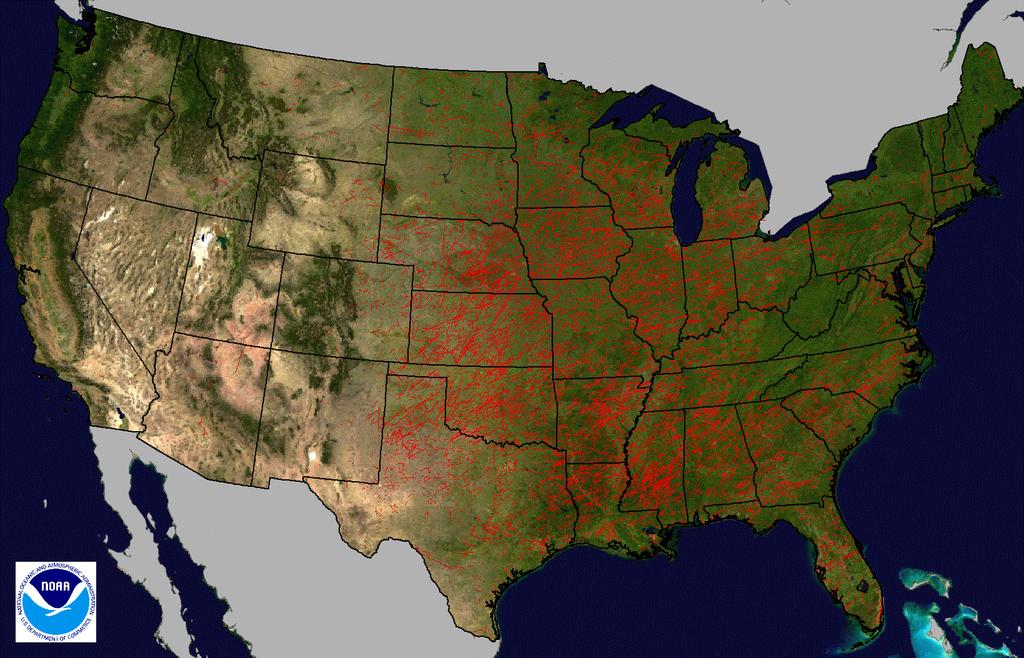
32 Storm Reports
33 Interesting Signals

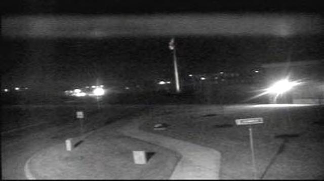
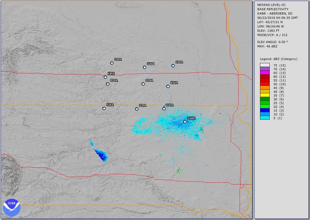
34 Radar Image 1 - F29A F29A
35 Radar Image 2 - F29A F29A

36 F29A Pressure and Seismic Radar Image 1 Radar Image 2
37 NWS Comparason
38 NWS Comparason KEMP R35A Data Sampling Comparison ASOS Station KEMP vs. TA Station R35A Pressure (mb) Gust Front 958 8/13/ :53:00 8/13/ :53:00 8/13/ :53:00 8/13/ :53:00 8/13/ :53:00 Time (UTC) 8/14/ :53:00 8/14/ :53:00 8/14/ :53:00 8/14/ :53:00
39 Barometric Pressure Variations Unfiltered Data
40 Atmospheric Gravity Wave Band Periods - 2 to 6 Hours
41 North propagating 2-6 hr GW S36A: 1,800 to 8,000 s 12
42 North propagating 2-6 hr GW 13

43 North propagating 2-6 hr GW 13
44 Tornado Prevalence

45 Jackson Tornado on 4/15/ A

46 Jackson Tornado on 4/15/ A 10 minutes Jackson, MS 22:35:59 UTC 6 hours


47 Jackson Tornado on 4/15/ A 10 minutes Jackson, MS 22:40:33 UTC 6 hours


48 Jackson Tornado on 4/15/ A 10 minutes

49 Jackson Tornado on 4/15/ A
50 Jackson Tornado on 4/15/ A 1 minute
51 Jackson Tornado on 4/15/ A Impulsive Rise and Drop 1 minute

52 Jackson Tornado on 4/15/ A High Frequency Signal 1 minute

53 Joplin Tornado 5/22/2011 T38A

54 Joplin Tornado 5/22/2011 T38A

55 Joplin Tornado 5/22/2011 T38A 1.7 km
56 Joplin Tornado 5/22/2011 T38A mb minutes minutes

57 Joplin Tornado 5/22/2011 T38A mb minutes Window of Tornado Crossing 55 minutes
58 Joplin Tornado 5/22/2011 T38A 2 minutes
59 Joplin Tornado 5/22/2011 T38A Impulsive Rise and Drop 2 minutes

60 Joplin Tornado 5/22/2011 T38A High Frequency Signal 2 minutes

61 Joplin Tornado 5/22/2011 T38A

62 Oklahoma Tornado on 4/27/2011 Y46A

63 Mesa Grande View

64 Mesa Grande View

65 HPWREN Photo Main challenge: A single lightning event can contain multiple branches covering a large area.
66 Data Integration The ANF is collaborating with Earth Networks and their Total Lightning Network (ENTLN) in order to identify thunder noise in our seismic data. All lightning locations shown are from the ENTLN
67 Mesa Grande Lightning ~ 7.5 km between CG1 and CG3

68 Seismic Data
69 Earthquake & Thunder Thunder (not aligned) Earthquake 10 seconds 10 seconds
70 Earthquake & Thunder


71 Earthquake & Thunder Often similar patterns

72 Earthquake & Thunder Thunder noise lined-up ENTLN Event time 10 seconds Seismic event stands out

73 Ground Truth Example Starting from a single event group from the ENTLN, identify thunder noise in seismic: One event with four separate origins IC - Cloud to Cloud CG - Cloud to Ground

74 Ground Truth Example

75 Ground Truth Example ENTLN Event time 5 seconds
76 Thunder review Thunder noise from lightning events readily poses challenges for seismic analysts Lightning can cover large areas vs. isolated seismic sources Large area acoustic signatures difficult to determine arrival times in data (though ballpark estimates possible) Signals from thunder can overlap, cross-over, and distort seismic waveforms
77 Data Fusion Earth Networks comprehensive Total Lightning Network (ENTLN) helps isolate specific thunder obs. Seismic analysts can regroup waveforms using lightning events as point source regions this helps isolate earthquake signatures Possibility of developing a real-time detector, though this would be difficult without supplemental data such as ENTLN

78 Russian meteor

79 Russian meteor
80 Russian meteor

81 Russian meteor

82 Russian meteor

83 Russian meteor

84 Russian meteor Chelyabinsk, Russia, Equivalent ~100s Meteorite video
85 Conclusions Meteorological sensors can enhance understanding of seismic data Meteorological sensors can create opportunities for collaboration between different scientific communities real time monitoring hazards civil defense Seismic networks provide sites, permitting, real time telemetry Networks in Middle East using USArray technology are easily adaptable to extended environmental monitoring capabilities
6.6 Utilizing Lightning Locations to Optimize and Quality-Control Seismic Data
 6.6 Utilizing Lightning Locations to Optimize and Quality-Control Seismic Data Jonathan Tytell* 1, Juan C. Reyes 1, Frank Vernon 1, Christopher Sloop 2, Stan Heckman 2, Amena Ali 2 1 University of California,
5.3 Scientific Viability of the USArray Transportable Array Network As a Real-Time Weather Monitoring Platform
 5.3 Scientific Viability of the USArray Transportable Array Network As a Real-Time Weather Monitoring Platform Frank Vernon* 1, Jonathan Tytell 1, Bob Busby 2, Jennifer Eakins 1, Michael Hedlin 1, Andreas
Seismic Recording Station TA_109C Summary Report
 Seismic Recording Station TA_109C Summary Report Thank you for hosting station TA_109C on your property. We hope that you find the enclosed report interesting. Your station is one of the 2000 USArray seismic
Seismic Recording Station AZ_PFO Summary Report
 Seismic Recording Station AZ_PFO Summary Report Thank you for hosting station AZ_PFO on your property. We hope that you find the enclosed report interesting. Your station is one of the 2000 USArray seismic
DETECTION OF NATURALLY OCCURRING EVENTS FROM SMALL APERTURE INFRASOUND ARRAYS
 DETECTION OF NATURALLY OCCURRING EVENTS FROM SMALL APERTURE INFRASOUND ARRAYS John M. Noble and Stephen M. Tenney U.S. Army Research Laboratory 2800 Powder Mill Road, Adelphi, MD 20783 Phone:301-394-5663;
The EarthScope Geophysical Observatories. Slides courtesy Bob Woodward, Incorporated Research Institutions for Seismology (IRIS)
") The EarthScope Geophysical Observatories Slides courtesy Bob Woodward, Incorporated Research Institutions for Seismology (IRIS) 1 EarthScope Project Study the four dimensional structure and evolution of
The EarthScope Geophysical Observatories Slides courtesy Bob Woodward, Incorporated Research Institutions for Seismology (IRIS) 1 EarthScope Project Study the four dimensional structure and evolution of
San Jacinto Fault Zone and Sage Brush Flat High Frequency Experiments
 San Jacinto Fault Zone and Sage Brush Flat High Frequency Experiments Frank Vernon! Scripps Institution of Oceanography! University of California, San Diego!! 2015 Udine AUG! 13 March 2015! Southern California
28th Seismic Research Review: Ground-Based Nuclear Explosion Monitoring Technologies
 BASIC RESEARCH ON SEISMIC AND INFRASONIC MONITORING OF THE EUROPEAN ARCTIC Frode Ringdal, Tormod Kværna, Svein Mykkeltveit, Steven J. Gibbons, and Johannes Schweitzer NORSAR Sponsored by Army Space and
Improvements to Seismic Monitoring of the European Arctic Using Three-Component Array Processing at SPITS
 Improvements to Seismic Monitoring of the European Arctic Using Three-Component Array Processing at SPITS Steven J. Gibbons Johannes Schweitzer Frode Ringdal Tormod Kværna Svein Mykkeltveit Seismicity
Rupture Dynamics of Large Earthquakes inferred from Hydroacoustic Data
 Rupture Dynamics of Large Earthquakes inferred from Hydroacoustic Data Catherine de Groot-Hedlin Scripps Institution of Oceanography University of California, San Diego Great Sumatra Earthquake (Boxing
the IRIS Consortium Collaborative, Multi-user Facilities for Research and Education Briefing NSF Business Systems Review September 9, 2008
 the IRIS Consortium Collaborative, Multi-user Facilities for Research and Education Briefing NSF Business Systems Review September 9, 2008 A facilities program for collection and distribution of seismological
Seismic signals from tsunamis in the Pacific Ocean
 GEOPHYSICAL RESEARCH LETTERS, VOL. 35, L03305, doi:10.1029/2007gl032601, 2008 Seismic signals from tsunamis in the Pacific Ocean Gordon Shields 1 and J. Roger Bowman 1 Received 8 November 2007; revised
4 Forecasting Weather
 CHAPTER 16 4 Forecasting Weather SECTION Understanding Weather BEFORE YOU READ After you read this section, you should be able to answer these questions: What instruments are used to forecast weather?
Weather Merit Badge Worksheet Hiller Aviation Museum
 Weather Merit Badge Worksheet Hiller Aviation Museum This worksheet is not required but is designed to help you complete the Aviation Merit Badge requirements. No one can add to or subtract from the Boy
R E C E N T P R O G R E S S A N D F U T U R E O P P O R T U N I T I E S I N V O L C A N O M O N I T O R I N G U S I N G I N F R A S O U N D
 R E C E N T P R O G R E S S A N D F U T U R E O P P O R T U N I T I E S I N V O L C A N O M O N I T O R I N G U S I N G I N F R A S O U N D D A V I D F E E G E O P H Y S I C A L I N S T I T U T E A L A
REGIONAL OBSERVATIONS OF MINING BLASTS BY THE GSETT-3 SEISMIC MONITORING SYSTEM
 REGIONAL OBSERVATIONS OF MINING BLASTS BY THE GSETT-3 SEISMIC MONITORING SYSTEM Brian W. Stump and D. Craig Pearson Los Alamos National Laboratory EES-3, MS-C335 Los Alamos, NM 87545 The cessation of testing
RECENT ADVANCES IN SEISMIC AND INFRASONIC ANALYSES OF VOLCANIC ERUPTIONS AND POTENTIAL FOR USING EARTHSCOPE DATA
 RECENT ADVANCES IN SEISMIC AND INFRASONIC ANALYSES OF VOLCANIC ERUPTIONS AND POTENTIAL FOR USING EARTHSCOPE DATA DAVID FEE WILSON ALASKA TECHNICAL CENTER, ALASKA VOLCANO OBSERVATORY GEOPHYSICAL INSTITUTE,
P3.1 Development of MOS Thunderstorm and Severe Thunderstorm Forecast Equations with Multiple Data Sources
 P3.1 Development of MOS Thunderstorm and Severe Thunderstorm Forecast Equations with Multiple Data Sources Kathryn K. Hughes * Meteorological Development Laboratory Office of Science and Technology National
Notes on Comparing the Nano-Resolution Depth Sensor to the Co-located Ocean Bottom Seismometer at MARS
 Notes on Comparing the Nano-Resolution Depth Sensor to the Co-located Ocean Bottom Seismometer at MARS Elena Tolkova, Theo Schaad 1 1 Paroscientific, Inc., and Quartz Seismic Sensors, Inc. October 15,
Absolute strain determination from a calibrated seismic field experiment
 Absolute strain determination Absolute strain determination from a calibrated seismic field experiment David W. Eaton, Adam Pidlisecky, Robert J. Ferguson and Kevin W. Hall ABSTRACT The concepts of displacement
25th Seismic Research Review - Nuclear Explosion Monitoring: Building the Knowledge Base
 KARATAU, MAKANCHI, AND LOCATION IN WESTERN CHINA Lee K. Steck, George E. Randall, Michael L. Begnaud, Charlotte A. Rowe, and Aaron A. Velasco Los Alamos National Laboratory Sponsored by National Nuclear
Lightning Detection Systems
 Lightning Detection Systems Roger Carter, Spectrum Manager, UK Met Office ITU/WMO SEMINAR ON USE OF RADIO SPECTRUM FOR METEOROLOGY. 16 18 September 2009 Lightning Detection Systems Table of Contents Introduction
Performance of the GSN station KONO-IU,
 Performance of the GSN station KONO-IU, 1991-2009 A report in a series documenting the status of the Global Seismographic Network WQC Report 2010:9 February 28, 2010 Göran Ekström and Meredith Nettles
Innovative Technologies for the Gravitational-Wave Detectors LIGO and Virgo
 Innovative Technologies for the Gravitational-Wave Detectors LIGO and Virgo Jan Harms INFN, Sezione di Firenze On behalf of LIGO and Virgo 1 Global Network of Detectors LIGO GEO VIRGO KAGRA LIGO 2 Commissioning
Reading. What meteorological conditions precede a thunderstorm? Thunderstorms: ordinary or single cell storms, multicell storms, supercell storms
 Thunderstorms: ordinary or single cell storms, multicell storms, supercell storms Reading Ahrens, Chapter 14: Thunderstorms and Tornadoes This lecture + next (Lightning, tornadoes) will cover the topic.
Applications/Users for Improved S2S Forecasts
 Applications/Users for Improved S2S Forecasts Nolan Doesken Colorado Climate Center Colorado State University WSWC Precipitation Forecasting Workshop June 7-9, 2016 San Diego, CA First -- A short background
Virtual Tour of the Permanently Instrumented Field Sites
 Virtual Tour of the NEES@UCSB Permanently Instrumented Field Sites Your Tour Guide Jamison Steidl UC Santa Barbara http://nees.ucsb.edu NEES The George E. Brown Jr., Network for Earthquake Engineering
ON LINE ARCHIVE OF STORM PENETRATING DATA
 ON LINE ARCHIVE OF STORM PENETRATING DATA Matthew Beals, Donna V. Kliche, and Andrew G. Detwiler Institute of Atmospheric Sciences, South Dakota School of Mines and Technology, Rapid City, SD Steve Williams
Data Sharing at the National Research Institute for Earth Science and Disaster Resilience
 Data Sharing at the National Research Institute for Earth Science and Disaster Resilience Katsuhiko SHIOMI Network Center for Earthquake, Tsunami and Volcano, NIED 2017.12.05 International workshop on
Ocean Bottom Seismometer Augmentation of the NPAL Philippine Sea Experiment
 DISTRIBUTION STATEMENT A. Approved for public release; distribution is unlimited. Ocean Bottom Seismometer Augmentation of the NPAL 2010-2011 Philippine Sea Experiment Ralph A. Stephen Woods Hole Oceanographic
Overview of Meteor Science Research at the University of Western Ontario
 Overview of Meteor Science Research at the University of Western Ontario Dr. Peter Brown Dept. of Physics and Astronomy University of Western Ontario London, ON CANADA pbrown@uwo.ca Research Focus Western
WIND PROFILER NETWORK OF JAPAN METEOROLOGICAL AGENCY
 WIND PROFILER NETWORK OF JAPAN METEOROLOGICAL AGENCY Masahito Ishihara Japan Meteorological Agency CIMO Expert Team on Remote Sensing Upper-Air Technology and Techniques 14-17 March, 2005 Geneva, Switzerland
arxiv: v1 [physics.geo-ph] 31 Dec 2013
![arxiv: v1 [physics.geo-ph] 31 Dec 2013](/thumbs/95/125064092.jpg "arxiv: v1 [physics.geo-ph] 31 Dec 2013") Comparing the Nano-Resolution Depth Sensor to the Co-located Ocean Bottom Seismometer at MARS Elena Tolkova 1, Theo Schaad 2 1 NorthWest Research Associates 2 Paroscientific, Inc., and Quartz Seismic Sensors,
Comparing the Nano-Resolution Depth Sensor to the Co-located Ocean Bottom Seismometer at MARS Elena Tolkova 1, Theo Schaad 2 1 NorthWest Research Associates 2 Paroscientific, Inc., and Quartz Seismic Sensors,
Introduction to Climatology. GEOG/ENST 2331: Lecture 1
 Introduction to Climatology GEOG/ENST 2331: Lecture 1 Us! Graham Saunders (RC 2006C) graham.saundersl@lakeheadu.ca! Jason Freeburn (RC 2004) jtfreebu@lakeheadu.ca Graham Saunders! Australian Weather Bureau!
Multi-parameter investigations at Fuego and Santiaguito volcanoes
 Multi-parameter investigations at Fuego and Santiaguito volcanoes John Lyons Michigan Technological University PASI Workshop - January 2011, Costa Rica PIRE 0530109 Multi-parameter approach to studying
4 Forecasting Weather
 CHAPTER 2 4 Forecasting Weather SECTION Understanding Weather BEFORE YOU READ After you read this section, you should be able to answer these questions: What instruments are used to forecast weather? How
1. A few words about EarthScope and USArray. 3. Tomography using noise and Aki s method
 1. A few words about EarthScope and USArray 2. Surface-wave studies of the crust and mantle 3. Tomography using noise and Aki s method 4. Remarkable images of US crust (and basins)! Unlocking the Secrets
Monthly Magnetic Bulletin
 BRITISH GEOLOGICAL SURVEY Ascension Island Observatory Monthly Magnetic Bulletin March 2017 17/03/AS Crown copyright; Ordnance Survey ASCENSION ISLAND OBSERVATORY MAGNETIC DATA 1. Introduction Ascension
Linked Environments for Atmospheric Discovery: Web Services for Meteorological Research and Education
 Linked Environments for Atmospheric Discovery: Web Services for Meteorological Research and Education What Would YOU Do if These Were About to Occur? What THEY Do to Us!!! Each year in the US, mesoscale
Severe Thunderstorm Forecasting and Climatology in Arizona. Ken Drozd Warning Coordination Meteorologist NOAA/NWS Tucson, AZ
 Severe Thunderstorm Forecasting and Climatology in Arizona Ken Drozd Warning Coordination Meteorologist NOAA/NWS Tucson, AZ THUNDERSTORM FORMATION All thunderstorms result from the same necessary conditions
10/21/2012. Chapter 10 Thunderstorms. Part II. Growth and Development of ordinary Cell Thunderstorms Thunderstorm Electrification.
 Chapter 10 Thunderstorms Part I Growth and Development of ordinary Cell Thunderstorms Thunderstorm Electrification Tornadoes Part II Simplified model depicting the life cycle of an ordinary thunderstorm
Infrasounds from Venus quakes : Numerical modeling and balloon observation project
 Infrasounds from Venus quakes : Numerical modeling and balloon observation project R.F. Garcia, D. Mimoun, Q. Brissaud, G. Poler ISAE-SUPAERO, Toulouse, France S. Lebonnois LMD, Paris, France Atmospheric
Plans For Alaska and Yukon
 Transportable Array Plans For Alaska and Yukon Robert Busby, TA Manager Katrin Hafner, Chief of Operations Bob Woodward, Director USArray EarthScope National Meeting Raleigh NC May 13-15, 2013 1 Outline
Imaging sharp lateral velocity gradients using scattered waves on dense arrays: faults and basin edges
 2017 SCEC Proposal Report #17133 Imaging sharp lateral velocity gradients using scattered waves on dense arrays: faults and basin edges Principal Investigator Zhongwen Zhan Seismological Laboratory, California
Synthetic Weather Radar: Offshore Precipitation Capability
 Synthetic Weather Radar: Offshore Precipitation Capability Mark S. Veillette 5 December 2017 Sponsors: Randy Bass, FAA ANG-C6 and Rogan Flowers, FAA AJM-33 DISTRIBUTION STATEMENT A: Approved for public
Measuring Hail and Wind Ground-Truth to Facilitate Rapid Response
 Measuring Hail and Wind Ground-Truth to Facilitate Rapid Response Alex Kubicek CEO and Co founder Understory Weather alex.kubicek@understoryweather.com Overview Introduction to Understory Understory technology
Dr. Christopher M. Godfrey University of North Carolina at Asheville
 Surface and Upper-Air Observations Surface Observations Collect information for synoptic-scale weather Most surface observations are automated (e.g., Automated Surface Observing System) Also mesoscale
The importance of satellite data and products for RA1 in the WWRP strategy. Estelle de Coning World Weather Research Division
 The importance of satellite data and products for RA1 in the WWRP strategy Estelle de Coning World Weather Research Division Kofi Annan former UN Secretary-General (21 July 2016) "The poor need alerts
DR
 DR2003071 0 0 270 0 30 0 90 0 60 0 120 0 150 0 90 0 180 0 180 0 A) RadialReceiverFunctions B ackazimuth (in degrees relative to north) -135-90 -45 0 45 90 135 180-5.0-2.5 Tangential R eceiver Functions
Remote Detection and Monitoring of Volcanic Eruptions in the East African Rift
 Remote Detection and Monitoring of Volcanic Eruptions in the East African Rift Simon Carn 1, David Fee 2, Fred Prata 3 1 Department of Geological and Mining Engineering and Sciences, Michigan Technological
Scout s Address: City State Zip:
 WEATHER BYU Merit Badge Pow Wow Official Merit Badge Worksheet New 2014 Requirements Scout s Name: Instructor s Name: Scout s Address: City State Zip: Instructions 1. The Scout is to review the merit badge
South Bay Coastal Ocean Observing System California Clean Beaches Initiative
 South Bay Coastal Ocean Observing System California Clean Beaches Initiative Second Quarterly Report January, 2003 to City of Imperial Beach Eric Terrill 1 1 Scripps Institution of Oceanography, University
CoCoRaHS Monitoring Colorado s s Water Resources through Community Collaborations
 CoCoRaHS Monitoring Colorado s s Water Resources through Community Collaborations Nolan Doesken Colorado Climate Center Atmospheric Science Department Colorado State University Presented at Sustaining
Your Task: Read each slide then use the underlined red or underlined information to fill in your organizer.
 Severe Weather: Tornadoes and Hurricanes Thunderstorms and Lightning S6E4 d. Construct an explanation of the relationship between air pressure, weather fronts, and air masses and meteorological events
How to Effectively Use Weather Radar. Presented by: Robert Reale Company:
 How to Effectively Use Weather Radar Presented by: Robert Reale Company: Who Am I? What is WeatherWorks? WeatherWorks Private weather consulting firm located in Hackettstown, NJ Over 30 years in the snow
Weather Systems III: Thunderstorms and Twisters
 Weather Systems III: Thunderstorms and Twisters Review 1. Definition of airmasses? Bergeron classification of air masses 2. Surface weather analysis: Station model, wind speed code, present weather 3.
Seismic tests at Southern Ute Nation coal fire site
 Seismic tests at Southern Ute Nation coal fire site Sjoerd de Ridder and Seth S. Haines ABSTRACT We conducted a near surface seismic test at the Southern Ute Nation coal fire site near Durango, CO. The
Monthly Magnetic Bulletin
 BRITISH GEOLOGICAL SURVEY Ascension Island Observatory Monthly Magnetic Bulletin December 2008 08/12/AS Crown copyright; Ordnance Survey ASCENSION ISLAND OBSERVATORY MAGNETIC DATA 1. Introduction Ascension
Observing Weather: Making the Invisible Visible. Dr. Michael J. Passow
 Observing Weather: Making the Invisible Visible Dr. Michael J. Passow What Is Weather? Weather refers to the conditions of the atmosphere at a certain place and time. Weather differs from Climate, which
PSA on Extreme Weather Phenomena for NPP Paks
 PSA on Extreme Weather Phenomena for NPP Paks Tamás Siklóssy siklossyt@nubiki.hu WGRISK Technical Discussion on PSA Related to Weather-Induced Hazards Paris, 9 March, 2017 Background Level 1 Seismic PSA
Predicting Weather Conditions. Do you have a career as a meteorologist?
 Predicting Weather Conditions Do you have a career as a meteorologist? It is essential for students for know 1. Weather conditions and patterns can be based on weather data collected from various sources.
Advanced Workshop on Evaluating, Monitoring and Communicating Volcanic and Seismic Hazards in East Africa.
 2053-11 Advanced Workshop on Evaluating, Monitoring and Communicating Volcanic and Seismic Hazards in East Africa 17-28 August 2009 Seismic monitoring on volcanoes in a multi-disciplinary context Jürgen
AN ANALYSIS OF A SHALLOW COLD FRONT AND WAVE INTERACTIONS FROM THE PLOWS FIELD CAMPAIGN
 AN ANALYSIS OF A SHALLOW COLD FRONT AND WAVE INTERACTIONS FROM THE PLOWS FIELD CAMPAIGN P.105 Carter Hulsey and Kevin Knupp Severe Weather Institute and Radar & Lightning Laboratories, University of Alabama
Magnitude 7.0 N of ANCHORAGE, ALASKA
 A magnitude 7.0 earthquake occurred just before 8:30 am local time 8 miles north of Anchorage at a depth of 40.9 km (25.4 miles). There are reports of major infrastructure damage and damage to many homes
Infrasound observations of the 2008 explosive eruptions of Okmok and Kasatochi volcanoes, Alaska
 JOURNAL OF GEOPHYSICAL RESEARCH, VOL. 115,, doi:10.1029/2010jd013987, 2010 Infrasound observations of the 2008 explosive eruptions of Okmok and Kasatochi volcanoes, Alaska Kenneth M. Arnoult, 1 John V.
Use the terms from the following list to complete the sentences below. Each term may be used only once.
 Skills Worksheet Directed Reading Section: Air Masses Use the terms from the following list to complete the sentences below. Each term may be used only once. high pressure poles low pressure equator wind
Available online at ScienceDirect. Physics Procedia 74 (2015 )
") Available online at www.sciencedirect.com ScienceDirect Physics Procedia 74 (2015 ) 486 492 Conference of Fundamental Research and Particle Physics, 18-20 February 2015, Moscow, Russian Federation Studies
Available online at www.sciencedirect.com ScienceDirect Physics Procedia 74 (2015 ) 486 492 Conference of Fundamental Research and Particle Physics, 18-20 February 2015, Moscow, Russian Federation Studies
When Katrina hit California
 Click Here for Full Article GEOPHYSICAL RESEARCH LETTERS, VOL. 33, L17308, doi:10.1029/2006gl027270, 2006 When Katrina hit California Peter Gerstoft, 1 Michael C. Fehler, 2 and Karim G. Sabra 1 Received
An Application of Hydrometeorological Information
 An Application of Hydrometeorological Information Weather-proof Café: Hydro-meteorological information in managing weather risks 17 19 November 2012 National Taiwan University, Chinese Taipei Nikos Viktor
Seismogeodesy for rapid earthquake and tsunami characterization
 Seismogeodesy for rapid earthquake and tsunami characterization Yehuda Bock Scripps Orbit and Permanent Array Center Scripps Institution of Oceanography READI & NOAA-NASA Tsunami Early Warning Projects
Remote Sensing and Sensor Networks:
 SDG&E Meteorology Remote Sensing and Sensor Networks: Providing meteorological intelligence to support system operations Mike Espinoza Project Manager Steven Vanderburg Senior Meteorologist Brian D Agostino
DEPARTMENT OF EARTH & CLIMATE SCIENCES SAN FRANCISCO STATE UNIVERSITY. Metr Fall 2014 Test #1 September 30, 2014
 DEPARTMENT OF EARTH & CLIMATE SCIENCES SAN FRANCISCO STATE UNIVERSITY NAME Metr 302.02 Fall 2014 Test #1 September 30, 2014 200 pts (4 pts each answer) Part I. Surface Chart Interpretation. Questions 1
CHAPTER 13 WEATHER ANALYSIS AND FORECASTING MULTIPLE CHOICE QUESTIONS
 CHAPTER 13 WEATHER ANALYSIS AND FORECASTING MULTIPLE CHOICE QUESTIONS 1. The atmosphere is a continuous fluid that envelops the globe, so that weather observation, analysis, and forecasting require international
Magnitude 7.9 SE of KODIAK, ALASKA
 A magnitude 7.9 earthquake occurred at 12:31 am local time 181 miles southeast of Kodiak at a depth of 25 km (15.5 miles). There are no immediate reports of damage or fatalities. Light shaking from this
Improving real time observation and nowcasting RDT. E de Coning, M Gijben, B Maseko and L van Hemert Nowcasting and Very Short Range Forecasting
 Improving real time observation and nowcasting RDT E de Coning, M Gijben, B Maseko and L van Hemert Nowcasting and Very Short Range Forecasting Introduction Satellite Application Facilities (SAFs) are
LIGO: The Laser Interferometer Gravitational Wave Observatory
 LIGO: The Laser Interferometer Gravitational Wave Observatory Credit: Werner Benger/ZIB/AEI/CCT-LSU Michael Landry LIGO Hanford Observatory/Caltech for the LIGO Scientific Collaboration (LSC) http://www.ligo.org
Online material: Updated 3-D tomography model and plotting script with examples
 Model Update January 2010: Upper Mantle Heterogeneity beneath North merica from Traveltime Tomography with Global and usarray Transportable rray Data Scott urdick, Robert D. van der Hilst, Frank L. Vernon,
KING EDWARD POINT OBSERVATORY MAGNETIC DATA
 BRITISH GEOLOGICAL SURVEY King Edward d Point Observatory Monthly Magnetic Bulletin September 2018 18/09/KE King Edward Point (UK) Maps British Antarctic Survey KING EDWARD POINT OBSERVATORY MAGNETIC DATA
Weather - is the state of the atmosphere at a specific time & place
 Weather Section 1 Weather - is the state of the atmosphere at a specific time & place Includes such conditions as air pressure, wind, temperature, and moisture in the air The Sun s heat evaporates water
Empirical Green s Function Analysis of the Wells, Nevada, Earthquake Source
 Nevada Bureau of Mines and Geology Special Publication 36 Empirical Green s Function Analysis of the Wells, Nevada, Earthquake Source by Mendoza, C. 1 and Hartzell S. 2 1 Centro de Geociencias, Universidad
Recent activity. Current episode 12 years Transition between styles 4 periods of dome growth Since 2003, Vulcanian explosions (4 25 per day)
") Recent activity Current episode 12 years Transition between styles 4 periods of dome growth Since 2003, Vulcanian explosions (4 25 per day) 02 December 09 Explosions originating from dome e.g. 10 Jan 2010
Recent activity Current episode 12 years Transition between styles 4 periods of dome growth Since 2003, Vulcanian explosions (4 25 per day) 02 December 09 Explosions originating from dome e.g. 10 Jan 2010
Development of Innovative Technology to Provide Low-Cost Surface Atmospheric Observations in Data-sparse Regions
 Development of Innovative Technology to Provide Low-Cost Surface Atmospheric Observations in Data-sparse Regions Paul Kucera and Martin Steinson University Corporation for Atmospheric Research/COMET 3D-Printed
KING EDWARD POINT OBSERVATORY MAGNETIC DATA
 BRITISH GEOLOGICAL SURVEY King Edward d Point Observatory Monthly Magnetic Bulletin October 2018 18/10/KE King Edward Point (UK) Maps British Antarctic Survey KING EDWARD POINT OBSERVATORY MAGNETIC DATA
Responsive Traffic Management Through Short-Term Weather and Collision Prediction
 Responsive Traffic Management Through Short-Term Weather and Collision Prediction Presenter: Stevanus A. Tjandra, Ph.D. City of Edmonton Office of Traffic Safety (OTS) Co-authors: Yongsheng Chen, Ph.D.,
The Integration of WRF Model Forecasts for Mesoscale Convective Systems Interacting with the Mountains of Western North Carolina
 Proceedings of The National Conference On Undergraduate Research (NCUR) 2006 The University of North Carolina at Asheville Asheville, North Carolina April 6-8, 2006 The Integration of WRF Model Forecasts
INTERNATIONAL AIRWAYS VOLCANO WATCH OPERATIONS GROUP (IAVWOPSG)
") IAVWOPSG/6-IP/8 30/8/11 INTERNATIONAL AIRWAYS VOLCANO WATCH OPERATIONS GROUP (IAVWOPSG) SIXTH MEETING Dakar, Senegal, 19 to 23 September 2011 Agenda Item 6: Development of the IAVW 6.1: Improvement of
IAVWOPSG/6-IP/8 30/8/11 INTERNATIONAL AIRWAYS VOLCANO WATCH OPERATIONS GROUP (IAVWOPSG) SIXTH MEETING Dakar, Senegal, 19 to 23 September 2011 Agenda Item 6: Development of the IAVW 6.1: Improvement of
2008 Monitoring Research Review: Ground-Based Nuclear Explosion Monitoring Technologies
 EXTENSION OF THE CAUCASUS SEISMIC INFORMATION NETWORK STUDY INTO CENTRAL ASIA Randolph Martin 1, Mary L. Krasovec 1, Eileen Vergino 2, and M. Nafi Toksöz 3 New England Research 1, Lawrence Livermore National
Segmentation in episodic tremor and slip all along Cascadia
 Segmentation in episodic tremor and slip all along Cascadia Michael R. Brudzinski and Richard M. Allen Geology 35 (10) 907-910, 2007, doi: 10.1130/G23740A.1 Data Repository: Methods for Automated Data
Magnitude 8.2 NORTHWEST OF IQUIQUE, CHILE
 An 8.2-magnitude earthquake struck off the coast of northern Chile, generating a local tsunami. The USGS reported the earthquake was centered 95 km (59 miles) northwest of Iquique at a depth of 20.1km
Government of Sultanate of Oman Public Authority of Civil Aviation Directorate General of Meteorology. National Report To
 Government of Sultanate of Oman Public Authority of Civil Aviation Directorate General of Meteorology National Report To Panel on Tropical Cyclones in the Bay of Bengal And Arabian Sea 43rd Session, India
INFRASONIC SOURCE LOCATION OF THE APRIL 23, 2001, BOLIDE EVENT
 INFRASONIC SOURCE LOCATION OF THE APRIL 23, 2001, BOLIDE EVENT Milton Garces 1, Claus Hetzer 1, Kent Lindquist 2, Roger Hansen 2, John Olson 3, Charles Wilson 3, Douglas Drob 4, and Michael Hedlin 5 University
27th Seismic Research Review: Ground-Based Nuclear Explosion Monitoring Technologies UNDERSTANDING WIND-GENERATED INFRASOUND NOISE
 UNDERSTANDING WIND-GENERATED INFRASOUND NOISE Robert Woodward 1, Hans Israelsson 1, István Bondár 1, Keith McLaughlin 1, J. Roger Bowman 1, and Henry Bass 2 Science Applications International Corporation
Village Weather, Snow, Ice, Breakup, Flooding, Fire sites
 Village Weather, Snow, Ice, Breakup, Flooding, Fire sites What is the weather like now in Villages?... 1 BREAKUP:... 2 Flooding... 3 Fires... 5 Weather Predictability, Weather and Ice Advisories and How
TexNet and CISR: An Update on Monitoring and Understanding Seismicity in Texas
 TexNet and CISR: An Update on Monitoring and Understanding Seismicity in Texas Michael H. Young a, Alexandros Savvaidis a, Peter Hennings a, Ellen Rathje b a Bureau of Economic Geology, Jackson School
SEARCH FOR THE VARIATION IN SEISMIC NOISE DUE TO WIND AT AIGO WESTERN AUSTRALIA. Atul Kumar Singh July
 SEARCH FOR THE VARIATION IN SEISMIC NOISE DUE TO WIND AT AIGO WESTERN AUSTRALIA ABSTRACT Atul Kumar Singh July 25 2007 This paper describes a study of wind induced seismic noise at the site proposed for
Western U.S. Infrasonic Catalog: Illuminating infrasonic hot spots with the USArray
 JOURNAL OF GEOPHYSICAL RESEARCH, VOL. 116,, doi:10.1029/2011jb008579, 2011 Western U.S. Infrasonic Catalog: Illuminating infrasonic hot spots with the USArray Kristoffer T. Walker, 1 Richard Shelby, 1
TELESCOPES. How do they work?
 TELESCOPES How do they work? There are two types of Telescopes Refractor telescopes They use glass lenses Reflector telescopes They use mirrors and lenses Parts of a Telescope Tube - a long tube, made
Complex atmospheric-lithospheric observations of acoustic emission at «Karymshina» site in Kamchatka
 Complex atmospheric-lithospheric observations of acoustic emission at «Karymshina» site in Kamchatka Igor Larionov 1, 1 Institute of Cosmophysical Research and Radio Wave Propagation FEB RAS, Paratunka,
Alaska Earthquake Center. By Natalia A. Ruppert Seismic Network Manager
 Alaska Earthquake Center By Natalia A. Ruppert Seismic Network Manager Geophysical Institute, University of Alaska Fairbanks Alaska Earthquake Center mission and historical perspective! Regional seismic
Monthly Magnetic Bulletin
 BRITISH GEOLOGICAL SURVEY Jim Carrigan Observatory Prudhoe Bay Monthly Magnetic Bulletin May 2014 14/05/JC JIM CARRIGAN OBSERVATORY MAGNETIC DATA 1. Introduction Jim Carrigan observatory is the fourth