Lab 6: Earthquake Focal Mechanisms (35 points)
|
|
|
- Maximilian Greer
- 6 years ago
- Views:
Transcription
1 Lab 6: Earthquake Focal Mechanisms (35 points) Group Exercise 1. Drawing Nodal Planes (8 pts) The outline map below labeled Figure 4.60a shows the positions of two earthquakes recorded on the Mid-Atlantic ridge system. Lower hemispheres of focal spheres of earthquakes 1 and 2 are also shown in Figures 4.60b and 4.60c. a. Draw the nodal planes on Figures 4.60b and 4.60c. Remember that the nodal planes must be perpendicular to each other. You can't do this very accurately but you can draw the nodal planes with sufficient care to indicate that the nodal planes are perpendicular to each other and do divide the focal sphere into four sectors of equal size. b. Identify the fault types that generated earthquakes 1 and 2. c. Using the Figure 4.60a, determine which nodal plane is most likely to be the fault plane in each case. Briefly explain how you came to your conclusions. d. From the tectonic setting, what are the depth ranges you would expect for earthquakes 1 and 2? 1
2 2
3 Individual Activities In this section you will examine the October 1999 southern California Hector Mine earthquake. The maps and description below will give you some idea of where the earthquake took place and shows the pattern of aftershocks. The picture above shows the spatial relation of the Hector Mine earthquake to the major faults in California. It is close to the Garlock fault (labeled) and the San Andreas fault system (to the southwest). This excerpt from the Southern California Earthquake Data Center ( describes the quake: "At 2:46:44 am on the morning of Saturday, October 16, 1999, most of southern California, as well as parts of Arizona and Nevada, shook and rattled in the seismic wake of the largest earthquake to strike the area since the M 7.3 Landers earthquake of June 28, Originally measured at magnitude 7.0, this earthquake was centered in a remote part of the Mojave Desert The Hector Mine earthquake was preceded by a small cluster of foreshocks that begin about 20 hours before the onset of the mainshock. The largest of these foreshocks was a magnitude 3.8 tremor that occurred at 7:41 pm PDT on October 15. These foreshocks were in the same location as a cluster of aftershocks triggered by the 1992 Landers earthquake. When the mainshock struck, just before 2:47 am PDT, the rupture was somewhat slow in starting. But within about 10 seconds it was over, having ruptured in both directions (bilaterally) from the epicenter: north along the Lavic Lake fault for about 15 kilometers, and south along the Lavic Lake fault and the central Bullion fault for another 26 kilometers." 3

4 Below is a zoomed image of the fault location with topography, faults, nearby cities, aftershocks, and other significant seismicity. From Hector quakes as yellow solid circles; Lavic Lake fault, surface rupture shown in red Landers quakes as black circles; 1992 surface rupture shown in orange. TriNet stations as green triangles; (red epicenters 10/26/99) Egill Hauksson, Caltech. 4
5 1. Developing a fault plane solution data set from seismic records (8 pts) The table below lists the following quantities for a particular earthquake: (1) code of seismic station; (2) epicentral distance (Δ, in degrees of arc) of that station from the earthquake; (3) azimuth (Az) from earthquake to station; and (4) the sense of the first P- wave first motion (compression [C] or dilatation [D]) observed at that station. Follow the instructions in a-b to develop a data set from which you will plot a focal mechanism. Station Δ ( ) i ( ) Az ( ) First Motion NEW GW D GW C GW D HKT GW C GW C FFC GW D GW D DWPF COLA PAYG SJG GW D GW C NNA GW D YAK ESK KONO GW D a. The table below lists the "take-off" angle i for various values of epicentral angle Δ. Use that table to determine i for the P-wave ray which travels from the earthquake to each of the stations in the list above and enter the values into the appropriate column. 5
6 Δ ( ) i ( ) b. On an attached page, seismic recordings of this earthquake are given for several stations. Pen motions in the upward direction on the record indicate compressional motions while pen motions in the downward direction indicate dilatational motions. Examine these records and determine for each station whether the first P-wave motion is compressional or dilatational. Mark each recording with a "C" or "D" and an arrow pointing to the wave pulse you used to make the determination. Then use these observations to complete the "First Motion" column in the table above. 6
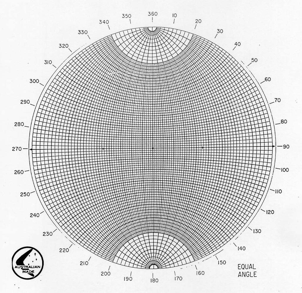
7 2. Plotting and interpreting the focal mechanism (19 pts) a. Use the data from the table you filled in above to plot the Cs and Ds on tracing paper placed over your stereonet. Use separate symbols for compression and dilatation and make a key for this on your plot. Be sure and trace the outer circle of the stereonet and mark N, S, E, and W along this circle. Also, remember that the take-off angle is measured FROM THE VERTICAL. That is, it is the angle from the center of the stereonet. It is NOT a dip angle. b. Fit two great circles through the distribution of first motions so that the quadrants of compressional and dilatational first P-wave motions are separated by these planes. These two planes must be perpendicular to each other. Ask for help if you're not sure how to do this. Also, all your data within each quadrant should describe the same motion, either compression or dilatation, not both. These planes represent the "nodal planes" for the earthquake radiation pattern meaning that they are planes along which there is little or no P- wave generation. c. From your "focal-plane solution" determined in a and b above, determine the type of faulting responsible for this earthquake. Was it normal, thrust, or strike-slip? d. Draw on your stereonet the sense(s) of motion which could account for this focal-plane solution. e. From the information given about the Hector Mine Earthquake, determine which of the nodal planes is the fault plane. Justify your answer. Is the slip right-lateral or left-lateral? f. Given your answer to e, make a simple interpretation of the Hector Mine fault in the greater context of California tectonics (i.e. a transform-faulted plate margin). You might want to address the following in your answer: is the Hector Mine fault a part of the San Andreas fault zone, or is it a part of a different fault system? 7
8 8
9 9
OCEAN/ESS 410. Lab 12. Earthquake Focal Mechanisms. You can write your answers to all be (e) on this paper.
 on this paper.") Lab 1. Earthquake Focal Mechanisms You can write your answers to all be (e) on this paper. In this class we are going to use P-wave first motions to obtain a double-couple focal mechanism for a subduction
Lab 1. Earthquake Focal Mechanisms You can write your answers to all be (e) on this paper. In this class we are going to use P-wave first motions to obtain a double-couple focal mechanism for a subduction
EARTHQUAKE LOCATIONS INDICATE PLATE BOUNDARIES EARTHQUAKE MECHANISMS SHOW MOTION
 6-1 6: EARTHQUAKE FOCAL MECHANISMS AND PLATE MOTIONS Hebgen Lake, Montana 1959 Ms 7.5 1 Stein & Wysession, 2003 Owens Valley, California 1872 Mw ~7.5 EARTHQUAKE LOCATIONS INDICATE PLATE BOUNDARIES EARTHQUAKE
LAB 6: Earthquakes & Faults
 Name School LAB 6: Earthquakes & Faults An earthquake is what happens when two blocks of the earth suddenly slip past one another. The surface where they slip is called the fault or fault plane. The location
BEYOND TRAVELTIMES AND EARTHQUAKE LOCATION What else can seismograms tell us about the nature of earthquakes on faults?
 BEYOND TRAVELTIMES AND EARTHQUAKE LOCATION What else can seismograms tell us about the nature of earthquakes on faults? What are some of the key parameters which we describe faults? GEOMETRICAL PROPERTIES
Earthquakes and Seismotectonics Chapter 5
 Earthquakes and Seismotectonics Chapter 5 What Creates Earthquakes? The term Earthquake is ambiguous: Applies to general shaking of the ground and to the source of the shaking We will talk about both,
Once you have opened the website with the link provided choose a force: Earthquakes
 Name: Once you have opened the website with the link provided choose a force: Earthquakes When do earthquakes happen? On the upper left menu, choose number 1. Read What is an Earthquake? Earthquakes happen
Earthquake. What is it? Can we predict it?
 Earthquake What is it? Can we predict it? What is an earthquake? Earthquake is the vibration (shaking) and/or displacement of the ground produced by the sudden release of energy. Rocks under stress accumulate
Magnitude 7.7 QUEEN CHARLOTTE ISLANDS REGION
 A major 7.7 magnitude earthquake struck at 8:04 PM local time in western British Columbia, Canada. The epicenter is located on Moresby Island, the southern large island in the Queen Charlotte Islands region.
they help tell Earth s story! Regents Earth Science With Ms. Connery
 they help tell Earth s story! Regents Earth Science With Ms. Connery EARTHQUAKE VOCABULARY earthquake fault convergent divergent transform (or transverse) seismic energy epicenter focus Richter scale magnitude
Magnitude 7.8 SCOTIA SEA
 A magnitude 7.8 earthquake has occurred in the South Orkney Island region in the Scotia Sea. According to the USGS, this earthquake is the latest in a series of moderate-tolarge earthquakes to strike this
San Andreas Movie Can It Happen?
 San Andreas Movie Can It Happen? Learning Objectives (LO) Lecture 14: Faults and Quakes Read: Chapter 10 and 11 Homework #12 due Thursday 12pm What we ll learn today:! 1. Compare strike-slip to dip-slip
Earthquakes. Chapter Test A. Multiple Choice. Write the letter of the correct answer on the line at the left.
 Earthquakes Chapter Test A Multiple Choice Write the letter of the correct answer on the line at the left. 1. Stress that pushes a mass of rock in two opposite directions is called a. shearing. b. tension.
Earthquakes.
 Earthquakes http://quake.usgs.gov/recenteqs/latestfault.htm An earthquake is a sudden motion or shaking of the Earth's crust, caused by the abrupt release of stored energy in the rocks beneath the surface.
INTRODUCTION TO EARTHQUAKES
 INTRODUCTION TO EARTHQUAKES Seismology = Study of earthquakes Seismologists = Scientists who study earthquakes Earthquake = Trembling or shaking of the earth s surface, usually as a result of the movement
Magnitude 6.9 GULF OF CALIFORNIA
 A pair of strong earthquakes struck off the coast of Mexico early Thursday only minutes apart. The magnitude 6.9 and 6.2 were centered about 85 miles northeast of Guerrero Negro in the Mexican state of
SUPPLEMENTARY INFORMATION
 doi:10.1038/nature11492 Figure S1 Short-period Seismic Energy Release Pattern Imaged by F-net. (a) Locations of broadband seismograph stations in Japanese F-net used for the 0.5-2.0 Hz P wave back-projection
Homework II Seismological Topics
 Revised September 6, 2012 EENS 6340/4340 Homework II Seismological Topics The Earth 1. The relationship between energy released, E, and earthquake magnitude, M, is given by the empirical relationship:
What We Know (and don t know)
") What We Know (and don t know) about the M5.1 La Habra Earthquake Dr. Robert Graves U.S. Geological Survey In collaboration with: Dr. Egill Hauksson and Dr. Thomas Göbel Caltech Dr. Elizabeth Cochran U.S.
What We Know (and don t know) about the M5.1 La Habra Earthquake Dr. Robert Graves U.S. Geological Survey In collaboration with: Dr. Egill Hauksson and Dr. Thomas Göbel Caltech Dr. Elizabeth Cochran U.S.
Investigation 5: What happens when plates move sideways past each other?
 Tectonics Investigation 5: Teacher Guide Investigation 5: What happens when plates move sideways past each other? Plates move sideways past each other at transform boundaries. At these boundaries, the
Magnitude 7.6 & 7.4 SOLOMON ISLANDS
 A magnitude 7.6 earthquake struck near the Solomon Islands on Sunday morning local time; there were no immediate reports of damage. The earthquake was centered 100 km (60 miles) south of Kira Kira, a town
LAB. Balboa Heights, Panama. Boulder, Colorado. Mexico City, Mexico. Data Table. Difference Between P-wave and S-wave. S-wave Arrival Time
 Name: Date: Lab Period: Locating the Epicenter of an Earthquake Introduction: The epicenter is the point on Earth's surface directly above an earthquake. Seismic stations detect earthquakes by the tracings
THE SEISMICITY OF THE EARTH
 OUTLINE THE SEISMICITY OF THE EARTH The earthquake source Types of earthquake: - from impacts and minor tremors to tectonic earthquakes, elastic rebound theory, deep earthquakes. Location of earthquakes:
Magnitude 7.1 NEAR THE EAST COAST OF HONSHU, JAPAN
 Japan was rattled by a strong aftershock and tsunami warning Thursday night nearly a month after a devastating earthquake and tsunami flattened the northeastern coast. This earthquake can be considered
Empirical Green s Function Analysis of the Wells, Nevada, Earthquake Source
 Nevada Bureau of Mines and Geology Special Publication 36 Empirical Green s Function Analysis of the Wells, Nevada, Earthquake Source by Mendoza, C. 1 and Hartzell S. 2 1 Centro de Geociencias, Universidad
Magnitude 6.5 OFFSHORE NORTHERN CALIFORNIA
 A powerful offshore earthquake that struck near the Northern California coast left a hodgepodge of debris for communities to sort through Sunday but spared residents any serious injury. After 25,000 people
RELOCATION OF THE MACHAZE AND LACERDA EARTHQUAKES IN MOZAMBIQUE AND THE RUPTURE PROCESS OF THE 2006 Mw7.0 MACHAZE EARTHQUAKE
 RELOCATION OF THE MACHAZE AND LACERDA EARTHQUAKES IN MOZAMBIQUE AND THE RUPTURE PROCESS OF THE 2006 Mw7.0 MACHAZE EARTHQUAKE Paulino C. FEITIO* Supervisors: Nobuo HURUKAWA** MEE07165 Toshiaki YOKOI** ABSTRACT
Earthquake Lab Introduction: Purpose: Method: Equipment needed: Fundamental Concepts and Key Terms:
 Earthquake Lab Introduction: Seismology is that branch of the geological sciences which is concerned with the study of earthquakes. Purpose: The purpose of this exercise is to introduce some fundamental
Earthquakes Modified
 Plate Tectonics Earthquakes Modified Recall that the earth s crust is broken into large pieces called. These slowly moving plates each other, each other, or from each other. This causes much on the rocks.
Earthquakes Chapter 19
 Earthquakes Chapter 19 Does not contain complete lecture notes. What is an earthquake An earthquake is the vibration of Earth produced by the rapid release of energy Energy released radiates in all directions
Magnitude 7.2 OAXACA, MEXICO
 A magnitude 7.2 earthquake has occurred in Oaxaca, Mexico at a depth of 24.6 km (15 miles). It was felt as far away as Guatemala. There have been no reported deaths directly linked to the earthquake. Emergency
Earthquakes Physical Geology 2017 Part 1: Exploring Earthquake distributions. Home butto California Earthquakes: 1) 2) 3) above
 2) 3) above") Earthquakes Physical Geology 2017 Adapted from a lab by Jennifer Wenner This lab is designed to give you experience exploring seismicity associated with different plate boundaries. You will examine seismograms
Earthquakes Physical Geology 2017 Adapted from a lab by Jennifer Wenner This lab is designed to give you experience exploring seismicity associated with different plate boundaries. You will examine seismograms
Earthquakes. Building Earth s Surface, Part 2. Science 330 Summer What is an earthquake?
 Earthquakes Building Earth s Surface, Part 2 Science 330 Summer 2005 What is an earthquake? An earthquake is the vibration of Earth produced by the rapid release of energy Energy released radiates in all
Foreshock Characteristics in Taiwan: Potential Earthquake Warning
 Foreshock Characteristics in Taiwan: Potential Earthquake Warning Cheng-Horng Lin Institute of Earth Sciences, Academia Sinica 2010/9/14 Outline Foreshocks and potential applications Previous foreshock
Earthquakes and Earthquake Hazards Earth - Chapter 11 Stan Hatfield Southwestern Illinois College
 Earthquakes and Earthquake Hazards Earth - Chapter 11 Stan Hatfield Southwestern Illinois College What Is an Earthquake? An earthquake is the vibration of Earth, produced by the rapid release of energy.
Earthquakes!! Be sure to fill in your notes sheet as you go through the power point!
 Earthquakes!! Be sure to fill in your notes sheet as you go through the power point! Plate Boundary Review Click on the link below to try some plate boundary movement simulations. The link will take you
Magnitude 6.3 SOUTH ISLAND OF NEW ZEALAND
 A magnitude 6.3 earthquake shook the southern New Zealand city of Christchurch. At least 100 people are reported dead, and there are reports of collapsed buildings, cracked streets and flooding due to
Elastic rebound theory
 Elastic rebound theory Focus epicenter - wave propagation Dip-Slip Fault - Normal Normal Fault vertical motion due to tensional stress Hanging wall moves down, relative to the footwall Opal Mountain, Mojave
Module 7: Plate Tectonics and Earth's Structure Topic 4 Content : Earthquakes Presentation Notes. Earthquakes
 Earthquakes 1 Topic 4 Content: Earthquakes Presentation Notes Earthquakes are vibrations within the Earth produced by the rapid release of energy from rocks that break under extreme stress. Earthquakes
CHAPTER 1 BASIC SEISMOLOGY AND EARTHQUAKE TERMINOLGY. Earth Formation Plate Tectonics Sources of Earthquakes...
 CHAPTER 1 BASIC SEISMOLOGY AND EARTHQUAKE TERMINOLGY Earth Formation... 1-2 Plate Tectonics... 1-2 Sources of Earthquakes... 1-3 Earth Faults... 1-4 Fault Creep... 1-5 California Faults... 1-6 Earthquake
Magnitude 8.2 NORTHWEST OF IQUIQUE, CHILE
 An 8.2-magnitude earthquake struck off the coast of northern Chile, generating a local tsunami. The USGS reported the earthquake was centered 95 km (59 miles) northwest of Iquique at a depth of 20.1km
Magnitude 7.4 SOUTH GEORGIA ISLAND REGION
 A magnitude 7.4 earthquake occurred in the South Georgia Island Region. South Georgia Island is a British territory in the South Atlantic Ocean that lies about 800 miles east of the Falkland Islands. It
Figure Diagram of earth movements produced by (a) P-waves and (b) S-waves.
 P-waves and (b) S-waves.") Geology 101 Name(s): Lab 10: Earthquakes When the stresses in a rock (which may or may not already be faulted) exceed the tensile strength of the rock, the rock ruptures at a point called the focus or
Geology 101 Name(s): Lab 10: Earthquakes When the stresses in a rock (which may or may not already be faulted) exceed the tensile strength of the rock, the rock ruptures at a point called the focus or
Earthquake stress drop estimates: What are they telling us?
 Earthquake stress drop estimates: What are they telling us? Peter Shearer IGPP/SIO/U.C. San Diego October 27, 2014 SCEC Community Stress Model Workshop Lots of data for big earthquakes (rupture dimensions,
SHAKE, RATTLE, AND ROLL INVESTIGATING EARTHQUAKES
 NAME DATE PARTNER(S) SHAKE, RATTLE, AND ROLL INVESTIGATING EARTHQUAKES The city of San Francisco was destroyed by a 7.8 magnitude earthquake that ruptured gas lines and set the city ablaze. March 28, 1964
Earthquakes and Earth s Interior
 - What are Earthquakes? Earthquakes and Earth s Interior - The shaking or trembling caused by the sudden release of energy - Usually associated with faulting or breaking of rocks - Continuing adjustment
Earthquakes Earth, 9th edition, Chapter 11 Key Concepts What is an earthquake? Earthquake focus and epicenter What is an earthquake?
 1 2 3 4 5 6 7 8 9 10 Earthquakes Earth, 9 th edition, Chapter 11 Key Concepts Earthquake basics. "" and locating earthquakes.. Destruction resulting from earthquakes. Predicting earthquakes. Earthquakes
Earthquakes Web Quest
 NAME: Earthquakes Web Quest DATE: TASK #1: http://projects.crustal.ucsb.edu/understanding/history/historyhtml Read through the slides and answer the following questions: What did our ancient ancestors
Chapter 15. Earthquakes and Plate Tectonics. what s the connection? At the boundaries friction causes plates to stick together.
 Chapter 15 Earthquakes and Plate Tectonics what s the connection? As with volcanoes, earthquakes are not randomly distributed over the globe At the boundaries friction causes plates to stick together.
Sendai Earthquake NE Japan March 11, Some explanatory slides Bob Stern, Dave Scholl, others updated March
 Sendai Earthquake NE Japan March 11, 2011 Some explanatory slides Bob Stern, Dave Scholl, others updated March 14 2011 Earth has 11 large plates and many more smaller ones. Plates are 100-200 km thick
Forces in Earth s Crust
 Forces in Earth s Crust This section explains how stresses in Earth s crust cause breaks, or faults, in the crust. The section also explains how faults and folds in Earth s crust form mountains. Use Target
Use a highlighter to mark the most important parts, or the parts. you want to remember in the background information.
 P a g e 1 Name A Fault Model Purpose: To explore the types of faults and how they affect the geosphere Background Information: A fault is an area of stress in the earth where broken rocks slide past each
Magnitude 7.9 SE of KODIAK, ALASKA
 A magnitude 7.9 earthquake occurred at 12:31 am local time 181 miles southeast of Kodiak at a depth of 25 km (15.5 miles). There are no immediate reports of damage or fatalities. Light shaking from this
C) 10:20:40 A) the difference between the arrival times of the P -wave and the S -wave
 10:20:40 A) the difference between the arrival times of the P -wave and the S -wave") 1. The arrival time of the first earthquake P-wave at a seismograph station was 10:11:20 (hours:minutes:seconds). If the epicenter of the earthquake is 8000 km away, what was the approximate arrival time
1. The arrival time of the first earthquake P-wave at a seismograph station was 10:11:20 (hours:minutes:seconds). If the epicenter of the earthquake is 8000 km away, what was the approximate arrival time
Plate Tectonics and Earth s Structure
 Plate Tectonics and Earth s Structure Chapter Eight: Plate Tectonics Chapter Nine: Earthquakes Chapter Ten: Volcanoes Chapter Nine: Earthquakes 9.1 What is an Earthquake? 9.2 Seismic Waves 9.3 Measuring
Seismic Source Mechanism
 Seismic Source Mechanism Yuji Yagi (University of Tsukuba) Earthquake Earthquake is a term used to describe both failure process along a fault zone, and the resulting ground shaking and radiated seismic
On May 4, 2001, central Arkansas experienced an M=4.4 earthquake followed by a
 1. Introduction On May 4, 2001, central Arkansas experienced an M=4.4 earthquake followed by a surprisingly large number of small earthquakes. We recorded about 2500 above the ambient noise level on a
Limitations of Earthquake Triggering Models*
 Limitations of Earthquake Triggering Models* Peter Shearer IGPP/SIO/U.C. San Diego September 16, 2009 Earthquake Research Institute * in Southern California Why do earthquakes cluster in time and space?
Chapt pt 15 er EARTHQUAKES! BFRB P 215 ages -226
 Chapter 15 EARTHQUAKES! BFRB Pages 215-226226 Earthquake causes An earthquake is the shaking of the Earth s crust caused by a release of energy The movement of the Earth s plates causes most earthquakes
SUPPLEMENTARY INFORMATION
 SUPPLEMENTARY INFORMATION DOI: 1.138/NGEO177 The Long Precursory Phase of Most Large Interplate Earthquakes Supplementary Information Supplementary Methods 1. Data and Classification We select the earthquakes
Objective: You will learn to interpret a seismogram and, using differences in seismic waves, locate the epicenter of an earthquake.
 Earth Science Dynamic Crust Name Period Finding Epicenters Lab# Introduction: Earthquakes occur when there is movement along a fault. The friction between rock masses rubbing against one another generates
What is an Earthquake?
 Earthquakes What is an Earthquake? Earthquake - sometimes violent shaking of ground caused by movement of Earth s tectonic plates; creates seismic waves Often followed by smaller earthquakes (aftershocks);
Earthquakes 11/14/2014. Earthquakes Occur at All Boundaries. Earthquakes. Key Aspects of an Earthquake. Epicenter. Focus
 Earthquakes Earthquakes Caused by friction and movement between Earth s tectonic plates A release of force Often caused by a catch between two plates As plates slide by, they stick to each other When the
Preliminary Report on the 1995 Ridgecrest Earthquake Sequence in Eastern California
 Preliminary Report on the 1995 Ridgecrest Earthquake Sequence in Eastern California Egill Hauksson Kate Hutton Hiroo Kanamori Seismological Laboratory California Institute of Technology Lucile Jones James
Magnitude 7.1 SOUTH SANDWICH ISLANDS
 A magnitude 7.1 earthquake occurred at a depth of 164.7 km (102 miles) in the South Sandwich Islands, an uninhabited British territory off the coast of Argentina in the southern Atlantic Ocean. Antarctica
Magnitude 7.1 PERU. There are early reports of homes and roads collapsed leaving one dead and several dozen injured.
 A magnitude 7.1 earthquake has occurred offshore Peru. The earthquake struck just after 4 a.m. local time and was centered near the coast of Peru, 40 km (25 miles) south-southwest of Acari, Peru at a depth
Geo736: Seismicity and California s Active Faults Introduction
 Geo736: Seismicity and California s Active Faults Course Notes: S. G. Wesnousky Spring 2018 Introduction California sits on the boundary of the Pacific - North American plate boundary (Figure 1). Relative
Crustal deformation by the Southeast-off Kii Peninsula Earthquake
 Crustal deformation by the Southeast-off Kii Peninsula Earthquake 51 Crustal deformation by the Southeast-off Kii Peninsula Earthquake Tetsuro IMAKIIRE, Shinzaburo OZAWA, Hiroshi YARAI, Takuya NISHIMURA
Part 2 - Engineering Characterization of Earthquakes and Seismic Hazard. Earthquake Environment
 Part 2 - Engineering Characterization of Earthquakes and Seismic Hazard Ultimately what we want is a seismic intensity measure that will allow us to quantify effect of an earthquake on a structure. S a
What causes an earthquake? Giant snakes, turtles, catfish, and spiders?
 What causes an earthquake? Giant snakes, turtles, catfish, and spiders? What causes an earthquake? The movement of Earth s plates creates enormous forces that squeeze or pull the rock in the crust as if
Determining the Earthquake Epicenter: Japan
 Practice Name: Hour: Determining the Earthquake Epicenter: Japan Measuring the S-P interval There are hundreds of seismic data recording stations throughout the United States and the rest of the world.
Tsunami waves swept away houses and cars in northern Japan and pushed ships aground.
 Japan was struck by a magnitude 8.9 earthquake off its northeastern coast Friday. This is one of the largest earthquakes that Japan has ever experienced. In downtown Tokyo, large buildings shook violently
6. The lithosphere is
 Name: APES: Geology and Nonrenewable Mineral Resources Earth Composition and Structure Webquest Date: I. Earth Structure http://scign.jpl.nasa.gov/learn/plate1.htm Click on the button press here to see
Today: Basic regional framework. Western U.S. setting Eastern California Shear Zone (ECSZ) 1992 Landers EQ 1999 Hector Mine EQ Fault structure
 1992 Landers EQ 1999 Hector Mine EQ Fault structure") Today: Basic regional framework Western U.S. setting Eastern California Shear Zone (ECSZ) 1992 Landers EQ 1999 Hector Mine EQ Fault structure 1 2 Mojave and Southern Basin and Range - distribution of strike-slip
Today: Basic regional framework Western U.S. setting Eastern California Shear Zone (ECSZ) 1992 Landers EQ 1999 Hector Mine EQ Fault structure 1 2 Mojave and Southern Basin and Range - distribution of strike-slip
5. EARTHQUAKES AND EARTH S INTERIOR
 LAST NAME (ALL IN CAPS): FIRST NAME: 5. EARTHQUAKES AND EARTH S INTERIOR EARTHQUAKE An earthquake is ground shaking caused by sudden and rapid movement of one block of rock slipping past another along
Magnitude 7.3 OFFSHORE EL SALVADOR
 A magnitude 7.3 earthquake struck off the Pacific coast of Central America late Monday night, early reports indicate one death. The earthquake occurred at a depth of 40 km (24.9 miles). Its epicenter was
Earthquake Stress Drops in Southern California
 Earthquake Stress Drops in Southern California Peter Shearer IGPP/SIO/U.C. San Diego September 11, 2009 Earthquake Research Institute Lots of data for big earthquakes (rupture dimensions, slip history,
of other regional earthquakes (e.g. Zoback and Zoback, 1980). I also want to find out
. I also want to find out") 4. Focal Mechanism Solutions A way to investigate source properties of the 2001 sequence is to attempt finding well-constrained focal mechanism solutions to determine if they are consistent with those
4. Focal Mechanism Solutions A way to investigate source properties of the 2001 sequence is to attempt finding well-constrained focal mechanism solutions to determine if they are consistent with those
Earthquakes = shaking of Earth because of a rapid release of energy
 There are more than 30,000 earthquakes worldwide each year! Earthquakes = shaking of Earth because of a rapid release of energy usually because of movement of tectonic plates Most earthquakes last for
Magnitude 7.1 PHILIPPINES
 A magnitude 7.1 earthquake struck in the southeastern Philippines just after 8 am local time Tuesday morning killing 82 people and reducing a 17 th century church to rubble. Offices and schools were closed
Physical Geology Lab. Teacher Check (show your screen to your teacher) Part ONE: Dynamic Earth. Continents Over Time.
 Part ONE: Dynamic Earth. Continents Over Time.") Physical Geology Lab Name Hour Part ONE: Dynamic Earth Earth s Structure Name the Layer: The only liquid layer Only a few miles thick (under oceans) Mostly solid iron and nickel Made of hot, semi-solid
Physical Geology Lab Name Hour Part ONE: Dynamic Earth Earth s Structure Name the Layer: The only liquid layer Only a few miles thick (under oceans) Mostly solid iron and nickel Made of hot, semi-solid
A. Locate the Epicenter
 Name: Block: Earthquake Lab The goal of this portion of the lab is to learn how recording of earthquakes seismograms are used to locate earthquakes, determine their magnitudes, and to understand the sense
Lab 9: Satellite Geodesy (35 points)
") Lab 9: Satellite Geodesy (35 points) Here you will work with GPS Time Series data to explore plate motion and deformation in California. This lab modifies an exercise found here: http://www.unavco.org:8080/cws/pbonucleus/draftresources/sanandreas/
Lab 9: Satellite Geodesy (35 points) Here you will work with GPS Time Series data to explore plate motion and deformation in California. This lab modifies an exercise found here: http://www.unavco.org:8080/cws/pbonucleus/draftresources/sanandreas/
Plate Tectonics - Demonstration
 Name: Reference: Prof. Larry Braile - Educational Resources Copyright 2000. L. Braile. Permission granted for reproduction for non-commercial uses. http://web.ics.purdue.edu/~braile/indexlinks/educ.htm
UNIT - 7 EARTHQUAKES
 UNIT - 7 EARTHQUAKES WHAT IS AN EARTHQUAKE An earthquake is a sudden motion or trembling of the Earth caused by the abrupt release of energy that is stored in rocks. Modern geologists know that most earthquakes
Figure Diagram of earth movements produced by (a) P-waves and (b) S-waves.
 P-waves and (b) S-waves.") Geology 101 Name(s): Lab 11: Earthquakes When the stresses in a rock (which may or may not already be faulted) exceed the tensile strength of the rock, the rock ruptures at a point called the focus or
Geology 101 Name(s): Lab 11: Earthquakes When the stresses in a rock (which may or may not already be faulted) exceed the tensile strength of the rock, the rock ruptures at a point called the focus or
The 1992 Landers Earthquake Sequence: Seismological Observations
 JOURNAL OF GEOPHYSCAL RESEARCH, VOL. 98, NO. Bll, PAGES 19,835-19,858, NOVEMBER 1, 1993 The 1992 Landers Earthquake Sequence: Seismological Observations EGLL HAUKSSON, LUCLE M. JONES,2 KAlE HUTON,1 AND
8.1b EARTHQUAKES REVIEW
 8.1b EARTHQUAKES REVIEW Directions To prepare for your assessment, review your notes, your student sheets, and the reading selections for Lessons 1 through 8. Then answer these questions: 1 Explain what
Lab Activity Locating Epicenters
 Lab Activity Locating Epicenters Key Features: Analyzing Seismograms P-waves & S-waves Using ESRT page 11 Drawing Epicenter Circles By Kaitlin Coder https://www.teacherspayteachers.com/store/nys-earth-science-and-living-environment-regents
Which lettered location has the highest elevation? A) A B) B C) C D) D
 A B) B C) C D) D") 1. New York State's highest peak, Mt. Marcy, is located at approximately A) 44 10' N 74 05' W B) 44 05' N 73 55' W C) 73 55' N 44 10' W D) 74 05' N 44 05' W 2. Four locations, A, B, C, and D, are represented
1. New York State's highest peak, Mt. Marcy, is located at approximately A) 44 10' N 74 05' W B) 44 05' N 73 55' W C) 73 55' N 44 10' W D) 74 05' N 44 05' W 2. Four locations, A, B, C, and D, are represented
1 How and Where Earthquakes Happen
 CHAPTER 12 1 How and Where Earthquakes Happen SECTION Earthquakes KEY IDEAS As you read this section, keep these questions in mind: What is elastic rebound? What are the similarities and differences between
Seismic Reflection Views of the 1994 Northridge Earthquake Hypocentral Region Using Aftershock Data and Imaging Techniques
 Seismic Reflection Views of the 1994 Northridge Earthquake Hypocentral Region Using Aftershock Data and Imaging Techniques SERGIO CHÁVEZ-PÉREZ and JOHN N. LOUIE SEISMOLOGICAL LABORATORY/174, MACKAY SCHOOL
Gutenberg-Richter Relationship: Magnitude vs. frequency of occurrence
 Quakes per year. Major = 7-7.9; Great = 8 or larger. Year Major quakes Great quakes 1969 15 1 1970 20 0 1971 19 1 1972 15 0 1973 13 0 1974 14 0 1975 14 1 1976 15 2 1977 11 2 1978 16 1 1979 13 0 1980 13
Geometry of co-seismic surface ruptures and tectonic meaning of the 23 October 2011 Mw 7.1 Van earthquake (East Anatolian Region, Turkey)
") Geometry of co-seismic surface ruptures and tectonic meaning of the 23 October 2011 Mw 7.1 Van earthquake (East Anatolian Region, Turkey) Bülent Dogan & Ahmet Karakaș. Journal of Structural Geology, 46(2013),
Geometry of co-seismic surface ruptures and tectonic meaning of the 23 October 2011 Mw 7.1 Van earthquake (East Anatolian Region, Turkey) Bülent Dogan & Ahmet Karakaș. Journal of Structural Geology, 46(2013),
GEOLOGIC MAPS PART II
 EARTH AND ENVIRONMENT THROUGH TIME LABORATORY - EES 1005 LABORATORY FIVE GEOLOGIC MAPS PART II Introduction Geologic maps of orogenic belts are much more complex than maps of the stable interior. Just
Dynamic Crust Practice
 1. Base your answer to the following question on the cross section below and on your knowledge of Earth science. The cross section represents the distance and age of ocean-floor bedrock found on both sides
2. Add the numbers in both columns of Summary Table. The total should equal the Total number of Quakes.
 Subduction lab Name Period Date The vast majority of earthquakes occur at plate boundaries. The deepest earthquakes occur at subduction boundaries where lithosphere is plunging down into the mantle. Deep
21. Earthquakes I (p ; 306)
") 21. Earthquakes I (p. 296-303; 306) How many people have been killed by earthquakes in the last 4,000 years? How many people have been killed by earthquakes in the past century? What two recent earthquakes
21. Earthquakes I (p. 296-303; 306) How many people have been killed by earthquakes in the last 4,000 years? How many people have been killed by earthquakes in the past century? What two recent earthquakes
Earthquakes How and Where Earthquakes Occur
 Earthquakes How and Where Earthquakes Occur PPT Modified from Troy HS Is there such thing as earthquake weather? Absolutely NOT!!! Geologists believe that there is no connection between weather and earthquakes.
Read & Learn Earthquakes & Faults
 Read Earthquakes & Faults Read the provided article. Use the information in the reading to answer the questions on the task cards on your answer sheet. Make sure your answers are in the correct spot on
Topic 12: Dynamic Earth Pracatice
 Name: Topic 12: Dynamic Earth Pracatice 1. Earth s outer core is best inferred to be A) liquid, with an average density of approximately 4 g/cm 3 B) liquid, with an average density of approximately 11