SONGS Seismic Research Projects
|
|
|
- Hilda Robinson
- 6 years ago
- Views:
Transcription

1 SONGS Seismic Research Projects Energy Division Independent Peer Review Group September 21, 2012
2 Agenda Background Overview Project Support Permits, Approvals, and Reviews Schedule Use of Advanced Technologies Onshore Projects Onshore/ Results 2
3 Background CEC issued the AB 1632 Report which was followed by a letter to SCE from Peevey directing seismic studies Report recommended SCE conduct seismic hazard research, such as 3D seismic reflection mapping, and installation of additional GPS units to further investigate the seismic setting at SONGS for implications of reliability impact CPUC authorized work to start at the end of 2011 with $10M in funding Decision D approved $64M in funding 3
4 Overview The projects will provide new geologic and seismic information relevant to SONGS seismic setting Designed to capture relevant seismic source data (level of activity and history) for: Newport-Inglewood/Rose Canyon (NI/RC) Fault Oceanside Blind Thrust (OBT) Fault Data examples: fault locations, geometries, types, slip rates, recurrence intervals 4
5 Project Support Scripps University of Nevada, Reno GeoPentech Padre Lamont Doherty Earth Observatory USGS GeoTrace Earth Consultants International SDSU UNAVCO NSF 5
6 Permits, Approvals, and Reviews Project 2D Deep Marine Seismic Reflection Survey (federal waters) 2D/3D Shallow and 3D Deep Marine Seismic Reflection Surveys (federal and state waters) Permits/Approvals/Reviews Incidental Harassment Authorization US Army Corps of Engineers 404 Permit California Coastal Commission Consistency Review Incidental Harassment Authorization California Coastal Commission Review Coastal Development Permit California State Lands Commission Permit (EIR) GPS Monitoring Camp Pendleton Permits/Lease Agreements Private Property Lease Agreements Seafloor Survey and Seafloor Sediment Sampling and Age Dating Marine Terrace and Coastal Deformation Investigations California State Lands Commission Geophysical/Geological Sampling Permit Permission from California State Parks Paleoseismic Trenching Caltrans Encroachment Permit City of San Diego Encroachment Permit Seismic Monitoring (federal waters) Camp Pendleton Permits/Lease Agreements US Army Corps of Engineers 404 Permit California Coastal Commission Consistency Review 6

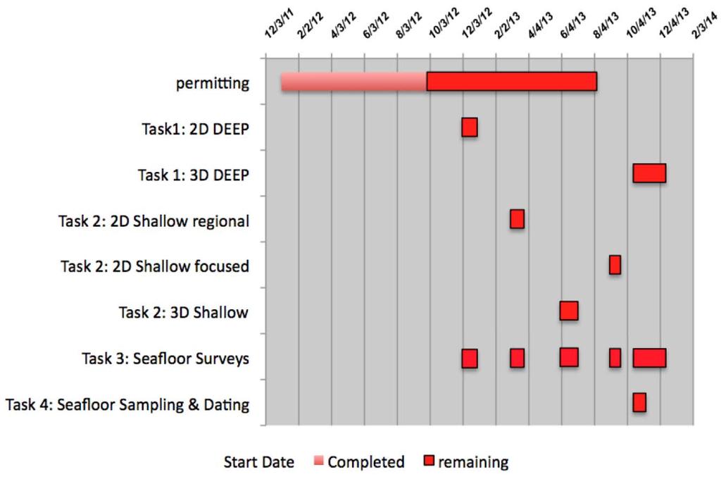
7 Schedule 7


8 Use of Advanced Technologies R/V Langseth 8
9 Historical Marine Geophysical Data Reprocessing and Reanalysis (see Tab 1) Reprocess and reanalyze existing seismic reflection data collected by SCE, USGS, petroleum industry, and academia Identify relevant existing seismic reflection surveys Reprocess appropriate historic seismic data using modern methods Reanalyze historic seismic data using modern 3D visualization software Use results to minimize the offshore survey area and time in the marine environment Provide input for environmental permitting activities, such as extent of survey area and location of ship tracks 9
10 2D Deep Marine Seismic Reflection Survey (see Tab 2) Collect and process 2D deep marine multi-channel seismic and geophysical data across the NI/RC and OBT faults Determination of target area Deploy ocean bottom seismometers (OBS) and onshore geophones Image geometry and architecture of the offshore fault systems Perform QA/QC Interpret the 2D deep data and define the location and size of the 3D deep survey 10


11 2D Deep Marine Seismic Reflection Survey (Continued) Figure shows 2D deep survey ship track lines and location of temporary ocean bottom seismometers and onshore geophones Source 3300 in 3 tuned air gun array Streamer 6 km, 12.5 m hydrophone group, 480 channels 2200 line km 28 OBS 40 land nodes (geophones) 27 days 11

12 2D Deep Marine Seismic Reflection Survey (Continued) 12
 Sorlien et al.")
13 2D Deep Marine Seismic Reflection Survey (Continued) Sorlien et al. (in prep) 13
 Rivero et al.")
14 2D Deep Marine Seismic Reflection Survey (Continued) Rivero et al. (2000) 14
15 3D Deep Marine Seismic Reflection Survey (see Tab 4) Collect and process 3D deep marine multi-channel seismic and geophysical data across the intersection of the NI/RC and OBT faults Results of 2D deep survey will identify if 3D deep survey is warranted Collect 3D deep data using multiple streamers and closely spaced track-lines, and perform QA/QC in real-time Process data to remove artifacts and increase signal-to-noise 15
")


16 3D Deep Marine Seismic Reflection Survey (continued) Green shaded box below shows a 40 km by 25 km area that will be imaged during 3D deep survey (60 days with 12.5 x 37.5 m bin size) 16
17 2D Shallow Marine Seismic Reflection Survey (see Tab 5) Collect and process 2D shallow marine seismic reflection data to image the geometry of the NI/RC Fault and shallow deformational features associated with the OBT Target area will be based on data obtained from the 2D deep survey and existing 2D shallow data Collect 2D shallow data and perform QA/QC in real-time Scripps and UNR will process the 2D shallow data Determine the location and size of the 3D shallow survey 17

18 2D Shallow Marine Seismic Reflection Survey (continued) The 2D shallow survey will be conducted in the operational area shown for the 2D deep survey but will also extend into California state waters 18
 Schematic of")

19 2D Shallow Marine Seismic Reflection Survey (continued) Schematic of shallow seismic imaging and generalized profile of offshore geologic structure 19


20 2D Shallow Marine Seismic Reflection Survey (continued) R/V Melville 90 in 3 GI gun 48 channel GeoEel streamer m hydrophone group spacing SAS CHIRP Nine 500 Hz 6 khz transducers Two 2-16 khz transducers Six 16 channel hydrophone arrays incorporating low noise pre-amplifier, 24-bit A/D conversion and data serialization New deep penetration CHIRP system (the Schocker) 20
21 3D Shallow Marine Seismic Reflection Survey (see Tab 6) Collect and process 3D shallow marine seismic reflection data to image the geometry of the NI/RC Fault and shallow deformational features associated with the OBT Target area will be based on data obtained from the 2D shallow survey Collect 3D shallow data using P-Cable and perform QA/QC in real-time GeoTrace will process the 3D shallow data with oversight by Scripps and UNR 3D shallow data will identify potential coring targets for the Seafloor Sediment Sampling and Age Dating project 21
22 3D Shallow Marine Seismic Reflection Survey (continued) P-Cable Survey Schematic drawing of the basic P-Cable components during operation 22

23 3D Shallow Marine Seismic Reflection Survey (continued) 30 day maximum cruise 16 x 10 km area max coverage 90 in 3 GI gun source 23
24 Seafloor Surveys (see Tab 7) Collect and process bathymetry, gravity, and magnetic data to image the geometry of the NI/RC and OBT faults Within the 2D deep survey area Performed in conjunction with deep and shallow surveys Fill in the gaps in the California Coastal and Marine Mapping Initiative data Process data and generate maps of seafloor relief, such as ledges, linear gulleys, and undisturbed seafloor High resolution bathymetry and back-scatter data also will help identify targets for follow-on seafloor sampling 24
")
25 Seafloor Surveys (continued) Seismic surveys will be conducted on R/V Langseth and R/V Melville (each have EM122 swath bathymetry systems) 25
26 Seafloor Sediment Sampling and Age Dating (see Tab 8) Collect organic and sediment samples using gravity, piston, and vibracores to aide in determining the history of the NI/RC and OBT faults Target area is based on the data recovered during 2D/3D shallow seismic reflection surveys Dateable samples will be collected on either side of the faults to determine the age of offset geologic layers imaged by 2D/3D shallow seismic reflection surveys Vibracores will be used in sandy environments on the nearshore shelf Gravity and piston cores will be used along the continental slope and rise where sediment is predominantly silts and clays 26
")
27 Seafloor Sediment Sampling and Age Dating (continued) 27

28 Seafloor Sediment Sampling and Age Dating (continued) Coring/Geotechnical Cruise R/V Melville Sequence of coring: Gravity core is deployed first Core barrel is 10 ft long Core weight is ~ 500 lbs Larger piston core is on the rail 28

29 Seafloor Sediment Sampling and Age Dating (continued) 10 m Vibracore Guide posts for vibracore head Vibracore head 29
30 30
31 Onshore Projects GPS Monitoring (see Tab 3) Install and monitor continuous GPS stations in the region surrounding SONGS to observe crustal deformation patterns and regional strain accumulation Site selection based on developing a uniform grid of instruments across the region Camp Pendleton Private land New stations will become part of the Southern California Integrated GPS Network (SCIGN) Annual data analysis ( ) 31

32 Onshore Projects GPS Monitoring (continued) Area Surrounding SONGS showing proposed stations on private land and Camp Pendleton 32
33 Onshore Projects Marine Terrace and Coastal Deformation Investigations (see Tab 10) Collect data related to vertical displacement along the southern Orange County and northern San Diego county coastline for use in assessing vertical deformation contributed by the NI/RC and OBT faults Collate existing marine terrace data and perform additional terrace mapping and dating to fill in gaps (e.g., aerial photo analyses, mapping, terrain profile measurements, age date sampling Determine the tectonic/seismic vertical elevation changes of the different marine terraces relative to past sea levels to evaluate vertical components of folding and faulting Use NOAA tide gauge data and NGS geodetic surveys to estimate the vertical movement of the coastline surrounding SONGS 33
 Diagram of modern and paleo marine terraces and associated")
34 Onshore Projects Marine Terrace and Coastal Deformation Investigations (continued) Diagram of modern and paleo marine terraces and associated features 34
35 Onshore Projects Paleoseismic Trenching (see Tab 11) Excavate trenches across the RC segment of the NI/RC Fault in San Diego county to measure fault displacement and establish fault history directly from the fault zone Sites selected based on a review of old aerial photographs in comparison with new aerial digital images where fault structures are observed Two to three trenches across and one parallel to the NI/RC fault will be excavated to characterize the three-dimensional geologic setting Samples will provide age information on the fault history 35
 Salt Creek")
36 Onshore Projects Paleoseismic Trenching (continued) Salt Creek Trench 36
 Salt Creek")
37 Onshore Projects Paleoseismic Trenching (continued) Salt Creek Trench 37
38 Onshore/ Existing Onshore and Offshore USGS Investigations (see Tab 9) Obtain recent onshore and offshore USGS geophysical surveys to update the SONGS seismic database Shallow water bathymetry data collected as part of the California Coastal and Marine Mapping Initiative 2D shallow seismic data across the NI/RC and OBT faults 38
39 Onshore/ Seismic Monitoring (see Tab 12) Install and maintain permanent onshore seismographs near SONGS and install and maintain temporary ocean bottom seismometers (OBS) offshore for a three year period Distribution of onshore seismographs is designed in fill in gaps in the CISN Data telemetered real time to the California Institute of Technology Install a single station seismograph at SONGS that will be maintained by the USGS Install, maintain, and eventually remove OBS instruments Three year deployment Download data annually and waveform archived 39

40 Onshore/ Seismic Monitoring (Continued) 40
41 Results Digital results will be provided to the EDD as each project is completed Data will be sent to repositories based on the specific data type Examples of repositories include: Scripps, UNR, Lamont Doherty Earth Observatory, UTIG Real-time onshore seismograph data will be telemetered to Southern California Earthquake Data Center 41
PG&E OFFSHORE CENTRAL COASTAL CALIFORNIA SEISMIC IMAGING PROJECT
 PG&E OFFSHORE CENTRAL COASTAL CALIFORNIA SEISMIC IMAGING PROJECT Public Scoping Meeting California State Lands Commission July 21, 2011 Project Area Project Commitments Assessment of the Hosgri, Shoreline,
SONGS SSC. Tom Freeman GeoPentech PRELIMINARY RESULTS
 SONGS SSC Tom Freeman GeoPentech PRELIMINARY RESULTS Focused Questions Summarize the tectonic setting What is the seismogenic thickness? Are you including deep ruptures in the upper mantle (~30 km)? Do
John Shaw CRUSTAL DEFORMATION MODEL: OBLIQUE CONVERGENCE IN THE INNER CALIFORNIA BORDERLANDS ACCOMMODATED BY ACTIVE STRIKE-SLIP AND REVERSE FAULTS
 CRUSTAL DEFORMATION MODEL: OBLIQUE CONVERGENCE IN THE INNER CALIFORNIA BORDERLANDS ACCOMMODATED BY ACTIVE STRIKE-SLIP AND REVERSE FAULTS August 2013 SONGS SSC SSHAC Workshop # 2 (August 12-14, 2013) Crustal
Diablo Canyon SSHAC Level 3 Study
 1 Diablo Canyon SSHAC Level 3 Study Workshop 1 Summary of SSC Hazard Significant Issues and Data Needed William Lettis November 29 to December 1, 2011 PG&E DCPP SSHAC Study 2 Hosgri Hosgri Location Hosgri
Geophysics the use of geology, laboratory & field experiments, mathematics, and instruments to study: Earthquakes and Volcanoes seismometers,
 Geophysics the use of geology, laboratory & field experiments, mathematics, and instruments to study: Earthquakes and Volcanoes seismometers, tiltmeters, EDM, remote sensing, Energy: oil, gas, hydrothermal
Differentiating earthquake tsunamis from other sources; how do we tell the difference?
 Differentiating earthquake tsunamis from other sources; how do we tell the difference? David Tappin (1), Stephan Grilli (2), Jeffrey Harris (2), Timothy Masterlark (3), James Kirby (4), Fengyan Shi Shi
overlie the seismogenic zone offshore Costa Rica, making the margin particularly well suited for combined land and ocean geophysical studies (Figure
 Chapter 1 Introduction Historically, highly destructive large magnitude (M w >7.0) underthrusting earthquakes nucleate along the shallow segment of subduction zone megathrust fault, and this region of
Originally published as:
 Originally published as: Henstock, T., McNeill, L., Dean, S., Barton, P., Tilmann, F., Rietbrock, A., Robinson, D., Gulick, S., Austin, J., Djajadihardja, Y., Natawidjaja, D., Permana, H., Bonneville,
Final Report for DOEI Project: Bottom Interaction in Long Range Acoustic Propagation
 Final Report for DOEI Project: Bottom Interaction in Long Range Acoustic Propagation Ralph A. Stephen Woods Hole Oceanographic Institution 360 Woods Hole Road (MS#24) Woods Hole, MA 02543 phone: (508)
Real time Monitoring System for Earthquakes and Tsunamis (DONET)
") Real time Monitoring System for Earthquakes and Tsunamis (DONET) NankaiTrough Yoshiyuki Kaneda Japan Agency for Marine-Earth Science and Technology (JAMSTEC) POGO@Seoul Presentation 1 Earthquakes in the
Real time Monitoring System for Earthquakes and Tsunamis (DONET) NankaiTrough Yoshiyuki Kaneda Japan Agency for Marine-Earth Science and Technology (JAMSTEC) POGO@Seoul Presentation 1 Earthquakes in the
Real Time Monitoring System for Megathrust Earthquakes and Tsunamis - Cabled Network System and Buoy System in Japan -
 Real Time Monitoring System for Megathrust Earthquakes and Tsunamis - Cabled Network System and Buoy System in Japan - 1 Subduction zones around the world Haiti Italy Turkey Tohoku Sichuan Taiwan Sumatra
EVALUATION OF TSUNAMI RISK FOR COASTAL SOUTHERN CALIFORNIA CITIES. Appendix A - Figures
 EVALUATION OF TSUNAMI RISK FOR COASTAL SOUTHERN CALIFORNIA CITIES Appendix A - Figures Figure 1.Map showing major faults of the southern California region. Northwest-trending faults are rightslip in character.
Marine Geophysical Methods: What Can and Cannot Be Done to Iden8fy Hazards to Dredging & Marine Construc8on
 Marine Geophysical Methods: What Can and Cannot Be Done to Iden8fy Hazards to Dredging & Marine Construc8on Marine Geophysics Sham or Savior? Seen alternatively as the silver bullet or snake oil, marine
Life after Cal: Adapting to Change and Enjoying your Time in Graduate School
 Life after Cal: Adapting to Change and Enjoying your Time in Graduate School Tyler Seaman Fall 2013 http://eps.berkeley.edu/~brimhall/alumni_student_forum/website_alumni_student_forum.htm Outline! Background!
Land seismic sources
 Seismic Sources HOW TO GENERATE SEISMIC WAVES? Exploration seismology mostly artificial sources à active technique Natural sources can also be used (e.g. earthquakes) usually for tectonic studies (passive
Earthquake patterns in the Flinders Ranges - Temporary network , preliminary results
 Earthquake patterns in the Flinders Ranges - Temporary network 2003-2006, preliminary results Objectives David Love 1, Phil Cummins 2, Natalie Balfour 3 1 Primary Industries and Resources South Australia
2013 SCEC Annual Report
 2013 SCEC Annual Report Collaborative research: Documentation of Tsunami Deposits in the Carpinteria Estuary: A signal of Great Earthquakes on the Pitas Point Thrust L. Reynolds, A. Simms, T.K. Rockwell,
Magnetotelluric and Seismic Investigation of Arc Melt Generation, Delivery, and Storage beneath Okmok Volcano
 Magnetotelluric and Seismic Investigation of Arc Melt Generation, Delivery, and Storage beneath Okmok Volcano PIs Ninfa Bennington (U. Wisconsin-Madison) and Kerry Key (Scripps Institution of Oceanography)
Regional-scale understanding of the geologic character and sand resources of the Atlantic inner continental shelf, Maine to Virginia
 Regional-scale understanding of the geologic character and sand resources of the Atlantic inner continental shelf, Maine to Virginia Workshop on Dredging, Beach Nourishment and Bird Conservation Atlantic
Lab 9: Satellite Geodesy (35 points)
") Lab 9: Satellite Geodesy (35 points) Here you will work with GPS Time Series data to explore plate motion and deformation in California. This lab modifies an exercise found here: http://www.unavco.org:8080/cws/pbonucleus/draftresources/sanandreas/
Lab 9: Satellite Geodesy (35 points) Here you will work with GPS Time Series data to explore plate motion and deformation in California. This lab modifies an exercise found here: http://www.unavco.org:8080/cws/pbonucleus/draftresources/sanandreas/
June 13-July 8, Astoria-Astoria
 MGL1211: Cascadia Basin Ridge to Trench June 13-July 8, Astoria-Astoria Motivation 1. How does the JdF plate evolve from ridge to trench and is there significant hydration of the crust and upper mantle
MARINE GEOLOGY & GEOGRAPHY
 MARINE GEOLOGY & GEOGRAPHY Bathymetry BATHYMETRY BATHYMETRY THE UNDERWATER EQUIVALENT TO TOPOGRAPHY THE STUDY OF WATER DEPTH A BATHYMETRIC MAP SHOWS FLOOR RELIEF OR TERRAIN AS CONTOUR LINES Bathymetry
Contemporary Tectonics and Seismicity of the Teton and Southern Yellowstone Fault Systems- Phase I
 University of Wyoming National Park Service Research Center Annual Report Volume 4 4th Annual Report, 1980 Article 16 1-1-1980 Contemporary Tectonics and Seismicity of the Teton and Southern Yellowstone
the IRIS Consortium Collaborative, Multi-user Facilities for Research and Education Briefing NSF Business Systems Review September 9, 2008
 the IRIS Consortium Collaborative, Multi-user Facilities for Research and Education Briefing NSF Business Systems Review September 9, 2008 A facilities program for collection and distribution of seismological
Guidelines for Site-Specific Seismic Hazard Reports for Essential and Hazardous Facilities and Major and Special-Occupancy Structures in Oregon
 Guidelines for Site-Specific Seismic Hazard Reports for Essential and Hazardous Facilities and Major and Special-Occupancy Structures in Oregon By the Oregon Board of Geologist Examiners and the Oregon
Bathymetry Data and Models: Best Practices
 Bathymetry Data and Models: Best Practices Barry Eakins & Lisa Taylor The NOAA National Geophysical Data Center Over 600 data types - from the core of the Earth to the surface of the Sun NGDC Bathymetry
Low-Latency Earthquake Displacement Fields for Tsunami Early Warning and Rapid Response Support
 Low-Latency Earthquake Displacement Fields for Tsunami Early Warning and Rapid Response Support Hans-Peter Plag, Geoffrey Blewitt Nevada Bureau of Mines and Geology and Seismological Laboratory University
General Geologic Setting and Seismicity of the FHWA Project Site in the New Madrid Seismic Zone
 General Geologic Setting and Seismicity of the FHWA Project Site in the New Madrid Seismic Zone David Hoffman University of Missouri Rolla Natural Hazards Mitigation Institute Civil, Architectural & Environmental
James A. Austin, Jr. phone: (512) fax: (512)
 fax: (512)") High-Resolution Seismic Surveying for Neogene-Quaternary Sequence Stratigraphy, Northern California Continental Shelf and Upper Slope, in Support of STRATAFORM Craig S. Fulthorpe University of Texas Institute
High-Resolution Seismic Surveying for Neogene-Quaternary Sequence Stratigraphy, Northern California Continental Shelf and Upper Slope, in Support of STRATAFORM Craig S. Fulthorpe University of Texas Institute
8.0 SUMMARY AND CONCLUSIONS
 8.0 SUMMARY AND CONCLUSIONS In November 2008, Pacific Gas and Electric (PG&E) informed the U.S. Nuclear Regulatory Commission (NRC) that preliminary results from the Diablo Canyon Power Plant (DCPP) Long
GPS Strain & Earthquakes Unit 5: 2014 South Napa earthquake GPS strain analysis student exercise
 GPS Strain & Earthquakes Unit 5: 2014 South Napa earthquake GPS strain analysis student exercise Strain Analysis Introduction Name: The earthquake cycle can be viewed as a process of slow strain accumulation
From Earthquakes to Mountains: the Earth s Crust in Motion
 Dean s Freshman Honor Seminar (SCI 110) Eric Calais Associate Professor of Geophysics Purdue University Department of Earth and Atmospheric Sciences ecalais@purdue.edu http:/www.eas.purdue.edu/~calais
A National Outer Continental Shelf Sand / Sediment Inventory
 A National Outer Continental Shelf Sand / Sediment Inventory Sand Resource Areas Lease Areas Lora Turner December 15, 2016 Restoring and Protecting Our Nation s Coasts through Stewardship of OCS Resources
3. UNDERWAY GEOPHYSICS 1
 Mayer, L., Pisias, N., Janecek, T., et al., 1992 Proceedings of the Ocean Drilling Program, Initial Reports, Vol. 138 3. UNDERWAY GEOPHYSICS 1 Stephen F. Bloomer 2 and Shipboard Scientific Party 3 INTRODUCTION
3. UNDERWAY GEOPHYSICS 1
 Sawyer, D.S., Whitmarsh, R.B., Klaus, A., et al., 1994 Proceedings of the Ocean Drilling Program, Initial Reports, Vol. 149 3. UNDERWAY GEOPHYSICS 1 Shipboard Scientific Party 2 EQUIPMENT AND METHODS Navigation
We A10 12 Common Reflection Angle Migration Revealing the Complex Deformation Structure beneath Forearc Basin in the Nankai Trough
 We A10 12 Common Reflection Angle Migration Revealing the Complex Deformation Structure beneath Forearc Basin in the Nankai Trough K. Shiraishi* (JAMSTEC), M. Robb (Emerson Paradigm), K. Hosgood (Emerson
Introduction to Acoustic Remote Sensing and Seafloor Mapping (AE4-E13) May 19, 2010
 May 19, 2010") Introduction to Acoustic Remote Sensing and Seafloor Mapping (AE4-E13) May 19, 2010 1 Delft Vermelding Institute onderdeel of Earth organisatie Observation and Space Systems Why Acoustic Remote Sensing?
Introduction to Acoustic Remote Sensing and Seafloor Mapping (AE4-E13) May 19, 2010 1 Delft Vermelding Institute onderdeel of Earth organisatie Observation and Space Systems Why Acoustic Remote Sensing?
Appendix H High Resolution Marine Seismic Reflection Surveys
 Appendix H High Resolution Marine Seismic Reflection Surveys Shoreline Fault Zone Report, Appendix H Seis. Reflection Page H-1 of 8 Introduction Single-channel seismic-reflection data were acquired in
4 Survey Datums. 4.1 Horizontal Datum Policy SURVEY DATUMS SEPTEMBER 2006
 4 Survey Datums Today s multi-organizational Project Development efforts require the use of common, accurate horizontal and vertical survey datums and consistent, precise control-survey procedures to ensure
Principles of the Global Positioning System Lecture 24
 12.540 Principles of the Global Positioning System Lecture 24 Prof. Thomas Herring http://geoweb.mit.edu/~tah/12.540 OVERVIEW Examination of results from Earthscope Reference frame definition: SNARF High-rate
Active Fault Observation and Research on Earthquake Potential in Taiwan. Chao-Chung Lin Central Geological Survey, Taiwan
 Active Fault Observation and Research on Earthquake Potential in Taiwan Chao-Chung Lin Central Geological Survey, Taiwan Outline Plate tectonic setting and historical earthquake disasters of Taiwan Geologic
Scientific Research on the Cascadia Subduction Zone that Will Help Improve Seismic Hazard Maps, Building Codes, and Other Risk-Mitigation Measures
 Scientific Research on the Cascadia Subduction Zone that Will Help Improve Seismic Hazard Maps, Building Codes, and Other Risk-Mitigation Measures Art Frankel U.S. Geological Survey Seattle, WA GeoPrisms-Earthscope
Chapter Overview. Bathymetry. Measuring Bathymetry. Measuring Bathymetry
 CHAPTER 3 Marine Provinces Chapter Overview The study of bathymetry determines ocean depths and ocean floor topography. Echo sounding and satellites are efficient bathymetric tools. Most ocean floor features
JAMSTEC Marine Geophysical Projects for Researches on Subduction Cycles and Deformation
 JAMSTEC Marine Geophysical Projects for Researches on Subduction Cycles and Deformation Shuichi Kodaira Research Center for Earthquake and Tsunami JAMSTEC JAMSTEC Marine Geophysical Projects Motivation:
Seismic Recording Station AZ_PFO Summary Report
 Seismic Recording Station AZ_PFO Summary Report Thank you for hosting station AZ_PFO on your property. We hope that you find the enclosed report interesting. Your station is one of the 2000 USArray seismic
IODP Science Evaluation Panel: Guidelines and Rationale for Site Characterization Data (Revised: August 2013)
") Site Characterization Data Guidelines IODP Science Evaluation Panel: Guidelines and Rationale for Site Characterization Data (Revised: August 2013) This document outlines the method and rationale for data
Site Characterization Data Guidelines IODP Science Evaluation Panel: Guidelines and Rationale for Site Characterization Data (Revised: August 2013) This document outlines the method and rationale for data
National Marine Sanctuary Program
 National Marine Sanctuary Program NMSP/USGS Joint Seabed Mapping Initiative: September 2004 AA National Ocean Service National Marine Sanctuaries Interim Report September 2004 Background: Since 2002,
NT10-09 Cruise Report KUMANO-NADA DONET Node Installation & Observatory Construction
 NT10-09 Cruise Report KUMANO-NADA DONET Node Installation & Observatory Construction June 2010 Table of Contents 1. Overview 2. Schedule 3. Dive Summary 4. Concluding Remarks 1. Overview DONET is a program
Potential Injection-Induced Seismicity Associated With Oil & Gas Development
 Potential Injection-Induced Seismicity Associated With Oil & Gas Development A primer on technical & regulatory considerations informing risk management & mitigation Second Edition September, 2017 www.statesfirstinitiative.org
Seismic Recording Station TA_109C Summary Report
 Seismic Recording Station TA_109C Summary Report Thank you for hosting station TA_109C on your property. We hope that you find the enclosed report interesting. Your station is one of the 2000 USArray seismic
Does the SDCP need inputs from geology?
 The British Geological Survey s Experience and Expertise in Supporting Projects such as the Sirte Depression Connection Project David Ovadia Director of International Kingsley Dunham Centre Keyworth Nottingham
ESTIMATES OF HORIZONTAL DISPLACEMENTS ASSOCIATED WITH THE 1999 TAIWAN EARTHQUAKE
 ESTIMATES OF HORIZONTAL DISPLACEMENTS ASSOCIATED WITH THE 1999 TAIWAN EARTHQUAKE C. C. Chang Department of Surveying and Mapping Engineering Chung Cheng Institute of Technology, Taiwan, ROC ABSTRACT A
Digital Elevation Model of Tutuila, American Samoa: Procedures, Data Sources, and Analysis
 Digital Elevation Model of Tutuila, American Samoa: Procedures, Data Sources, and Analysis Prepared for the National Tsunami Hazard Mitigation Program (NTHMP) by the NOAA National Geophysical Data Center
Indonesia Frontier Basin SUNDA (SU-08) NON-EXCLUSIVE 2-D SURVEY 3084km
 NON-EXCLUSIVE 2-D SURVEY 3084km") Indonesia Frontier Basin SUNDA (SU-08) NON-EXCLUSIVE 2-D SURVEY 3084km SEISMIC ACQUISITION PARAMETERS Acquisition Date: January - March 2008 Vessel: M/V Osprey Explorer Shooting Orientation: Strike-Dip
Indonesia Frontier Basin SUNDA (SU-08) NON-EXCLUSIVE 2-D SURVEY 3084km SEISMIC ACQUISITION PARAMETERS Acquisition Date: January - March 2008 Vessel: M/V Osprey Explorer Shooting Orientation: Strike-Dip
DIVISION OF COASTAL MANAGEMENT TO STUDY CURRENT LONG-TERM EROSION RATES ADJACENT TO TERMINAL GROINS
 DIVISION OF COASTAL MANAGEMENT TO STUDY CURRENT LONG-TERM EROSION RATES ADJACENT TO TERMINAL GROINS North Carolina Department of Environmental Quality Division of Coastal Management February 22, 2018 N.
DEEP SAN ANDREAS FAULT BOUNDARY STRUCTURE FROM MARINE MAGNETOTELLURICS A
 DEEP SAN ANDREAS FAULT BOUNDARY STRUCTURE FROM MARINE MAGNETOTELLURICS A proposal submitted to UC Shipfunds for New Horizon and Sproul shiptime Brent Wheelock Kerry Key and Steven Constable SUMMARY Knowledge
South Bay Coastal Ocean Observing System California Clean Beaches Initiative
 South Bay Coastal Ocean Observing System California Clean Beaches Initiative Second Quarterly Report January, 2003 to City of Imperial Beach Eric Terrill 1 1 Scripps Institution of Oceanography, University
OBS Park in Warsaw 2017 European OBS Technical Workshop Paris, France,
 OBS Park in Warsaw 2017 European OBS Technical Workshop Paris, France, 06-07.11.2017 Agenda The Team Collaboration The Legacy Our OBS BalTec KNIPAS Future plans Lessons learned The team Department of the
Heather Schlosser Army Corps of Engineers Coastal Studies Group August 28, 2008
 Got sand? Regional Sediment Management in Orange County Heather Schlosser Army Corps of Engineers Coastal Studies Group August 28, 2008 Regional Sediment Management Regional sediment management recognizes
Plate Tectonics Tutoiral. Questions. Teacher: Mrs. Zimmerman. Plate Tectonics and Mountains Practice Test
 Teacher: Mrs. Zimmerman Print Close Plate Tectonics and Mountains Practice Test Plate Tectonics Tutoiral URL: http://www.hartrao.ac.za/geodesy/tectonics.html Questions 1. Fossils of organisms that lived
Section 19.1: Forces Within Earth Section 19.2: Seismic Waves and Earth s Interior Section 19.3: Measuring and Locating.
 CH Earthquakes Section 19.1: Forces Within Earth Section 19.2: Seismic Waves and Earth s Interior Section 19.3: Measuring and Locating Earthquakes Section 19.4: Earthquakes and Society Section 19.1 Forces
South Bay Coastal Ocean Observing System California Clean Beaches Initiative
 South Bay Coastal Ocean Observing System California Clean Beaches Initiative Third Quarterly Report April, 2003 to City of Imperial Beach Eric Terrill 1 1 Scripps Institution of Oceanography, University
The Ocean Floor Earth Science, 13e Chapter 13
 The Ocean Floor Earth Science, 13e Chapter 13 Stanley C. Hatfield Southwestern Illinois College The vast world ocean Earth is often referred to as the blue planet Seventy-one percent of Earth s surface
EARTHQUAKE BAY THURSDAY FEBRUARY 16, 2017
 EARTHQUAKE BAY An evaluation of Geological Risks for Nuclear Waste Hazards at the San Onofre Nuclear Generating Station (SONGS) in San Diego and Orange Counties THURSDAY FEBRUARY 16, 2017 As recently as
NEW TOOLS TO IMPROVE DESKTOP SURVEYS
 NEW TOOLS TO IMPROVE DESKTOP SURVEYS Pablo Vengoechea (Telemediciones S.A.), Jorge O. García (Telemediciones S.A.), Email: Telemediciones S.A. / Cra. 46 94-17 Bogotá D.C.
Map shows 3 main features of ocean floor
 Map shows 3 main features of ocean floor 2017 Pearson Education, Inc. Chapter 3 Marine Provinces 2017 Pearson Education, Inc. 1 Chapter 3 Overview The study of bathymetry determines ocean depths and ocean
Chapter 1 Overview of Maps
 Chapter 1 Overview of Maps In this chapter you will learn about: Key points when working with maps General types of maps Incident specific maps Map legend and symbols Map sources A map is a navigational
Geodesy (InSAR, GPS, Gravity) and Big Earthquakes
 and Big Earthquakes") Geodesy (InSAR, GPS, Gravity) and Big Earthquakes Mathew Pritchard Teh-Ru A. Song Yuri Fialko Luis Rivera Mark Simons UJNR Earthquake Research Panel, Morioka, Japan - Nov 6, 2002 Goals Accurate and high
Geodesy (InSAR, GPS, Gravity) and Big Earthquakes Mathew Pritchard Teh-Ru A. Song Yuri Fialko Luis Rivera Mark Simons UJNR Earthquake Research Panel, Morioka, Japan - Nov 6, 2002 Goals Accurate and high
Susitna-Watana Hydroelectric Project (FERC No ) Site-Specific Seismic Hazard Study Study Plan Section 16.6
 Site-Specific Seismic Hazard Study Study Plan Section 16.6") (FERC No. 14241) Site-Specific Seismic Hazard Study Study Plan Section 16.6 Initial Study Report Part A: Sections 1-6, 8-9 Prepared for Prepared by MWH / Fugro June 2014 TABLE OF CONTENTS 1. Introduction...
(FERC No. 14241) Site-Specific Seismic Hazard Study Study Plan Section 16.6 Initial Study Report Part A: Sections 1-6, 8-9 Prepared for Prepared by MWH / Fugro June 2014 TABLE OF CONTENTS 1. Introduction...
UNOLS Ocean Surveyor ADCP Overview
 UNOLS Ocean Surveyor ADCP Overview p. 1/2 UNOLS Ocean Surveyor ADCP Overview Julia Hummon, Eric Firing hummon@hawaii.edu, efiring@hawaii.edu UNOLS Ocean Surveyor ADCP Overview p. 2/2 Outline Installations
Bathymetry Measures the vertical distance from the ocean surface to mountains, valleys, plains, and other sea floor features
 1 2 3 4 5 6 7 8 9 10 11 CHAPTER 3 Marine Provinces Chapter Overview The study of bathymetry determines ocean depths and ocean floor topography. Echo sounding and satellites are efficient bathymetric tools.
Offshore Evidence for Uplift Rate Boundaries. Hans AbramsonWard Diablo Canyon SSHAC SSC Workshop 2 November 7, 2012
 Offshore Evidence for Uplift Rate Boundaries Hans AbramsonWard Diablo Canyon SSHAC SSC Workshop 2 November 7, 2012 Questions asked by the TI team Discuss your ability to distinguish and correlate offshore
Seismological laboratory in Agua Negra tunnel
 Instituto Geofísico Sismológico Volponi Universidad Nacional de San Juan Seismological laboratory in Agua Negra tunnel Buenos Aires, Abril 2011 Why a Seismological laboratory in Agua Negra tunnel? Earthquake
Regional and Nearshore Bathymetry of American Samoa: Implications for Tsunami Run-Up and Public Awareness
 Regional and Nearshore Bathymetry of American Samoa: Implications for Tsunami Run-Up and Public Awareness Presentation U21D-07 2009 AGU Fall Meeting San Francisco Authors Dawn Wright Dept. of Geosciences,
Terms of reference ( c ) Marine seismic assets Marine Seismic Assets sub-committee
 Marine seismic assets Marine Seismic Assets sub-committee") Terms of reference ( c ) Marine seismic assets Marine Seismic Assets sub-committee Active source: Warren Wood, Beatrice Magnani, others OBS: Del Bohnenstiehl, others From the MSROC Terms of Reference (c)
Terms of reference ( c ) Marine seismic assets Marine Seismic Assets sub-committee Active source: Warren Wood, Beatrice Magnani, others OBS: Del Bohnenstiehl, others From the MSROC Terms of Reference (c)
Cruise report of KY11-06 Leg1
 Cruise report of KY11-06 Leg1 Cruise : KY11-06 /Leg1 / R/V Kaiyo Research subject: Construction of Seafloor observation Network for Earthquakes and Tsunamis Research Proposal by: Yoshiyuki KANEDA/JAMSTEC
Award #: N AASERT Award #: N LONG-TERM GOALS
 HIGH-RESOLUTION SEISMIC SURVEYING FOR NEOGENE- QUATERNARY SEQUENCE STRATIGRAPHY, NORTHERN CALIFORNIA CONTINENTAL SHELF AND UPPER SLOPE, IN SUPPORT OF STRATAFORM Craig S. Fulthorpe and James A. Austin,
Planning and Operating a Transition Zone 2D Seismic Survey on Lake Tanganyika*
 Planning and Operating a Transition Zone 2D Seismic Survey on Lake Tanganyika* Doug Roberts 1 and Jeremy P. FitzPatrick 2 Search and Discovery Article #41765 (2016) Posted January 25, 2016 *Adapted from
Earthquakes, Tsunamis and Nuclear Explosions: Open Data Exchange for Research and Monitoring in Seismology
 Earthquakes, Tsunamis and Nuclear Explosions: Open Data Exchange for Research and Monitoring in Seismology David Simpson IRIS Consortium Washington, DC Symposium on Data Sharing Plans for GEOSS and Benefits
crustal structure experiment beneath Wairarapa - Wellington area: results from SAHKE
 crustal structure experiment beneath Wairarapa - Wellington area: results from SAHKE Tim Stern and SAHKE team* * VUW, GNS, University of Southern California, University of Tokyo(Japan) SAHKE = Seismic
FloatSeis Technologies for Ultra-Deep Imaging Seismic Surveys
 FloatSeis Technologies for Ultra-Deep Imaging Seismic Surveys 25 th January, 2018 Aleksandr Nikitin a.nikitin@gwl-geo.com Geology Without Limits Overview 2011-2016 GWL Acquired over 43000 km 2D seismic
A Factor of 2-4 Improvement in Marine Gravity and Predicted Bathymetry from CryoSat, Jason-1, and Envisat Radar Altimetry: Arctic and Coastal Regions
 DISTRIBUTION STATEMENT A. Approved for public release; distribution is unlimited. A Factor of 2-4 Improvement in Marine Gravity and Predicted Bathymetry from CryoSat, Jason-1, and Envisat Radar Altimetry:
Earthquakes. Earthquake Magnitudes 10/1/2013. Environmental Geology Chapter 8 Earthquakes and Related Phenomena
 Environmental Geology Chapter 8 Earthquakes and Related Phenomena Fall 2013 Northridge 1994 Kobe 1995 Mexico City 1985 China 2008 Earthquakes Earthquake Magnitudes Earthquake Magnitudes Richter Magnitude
Plate Boundary Observatory Working Group for the Central and Northern San Andreas Fault System PBO-WG-CNSA
 Plate Boundary Observatory Working Group for the Central and Northern San Andreas Fault System PBO-WG-CNSA Introduction Our proposal focuses on the San Andreas fault system in central and northern California.
The 1700/01/26 Cascadia subduction zone Earthquake and Tsunami
 Jason R. Patton GEO 142 1/13/15 Abstract: Cascadia subduction zone earthquakes (CSZ) can generate strong ground shaking and deadly tsunamis. Geologists used sediment cores and stream bank exposures to
29. IMPLICATIONS OF DEEP SEA DRILLING, SITES 186 AND 187 ON ISLAND ARC STRUCTURE
 29. IMPLICATIONS OF DEEP SEA DRILLING, SITES 186 AND 187 ON ISLAND ARC STRUCTURE John A. Grow 1, Marine Physical Laboratory, Scripps Institution of Oceanography, La Jolla, California INTRODUCTION Pacific
to: Interseismic strain accumulation and the earthquake potential on the southern San
 Supplementary material to: Interseismic strain accumulation and the earthquake potential on the southern San Andreas fault system by Yuri Fialko Methods The San Bernardino-Coachella Valley segment of the
R/V Kairei Cruise Report KR Seismic study in the northwestern Pacific region. Jan. 4, 2011 Jan. 20, 2011
 R/V Kairei Cruise Report KR11-01 Seismic study in the northwestern Pacific region Jan. 4, 2011 Jan. 20, 2011 Japan Agency for Marine-Earth Science and Technology (JAMSTEC) Contents: 1.Cruise Information:
KECK REALTIME SEISMIC/GEODETIC BOREHOLE STATION. WHOI Ocean Bottom Seismograph Laboratory
 KECK REALTIME SEISMIC/GEODETIC BOREHOLE STATION WHOI Ocean Bottom Seismograph Laboratory W.M. Keck Foundation Award to Design and Construct a Real-Time Borehole Seismic and Geodetic Observatory for Deployment
Section Forces Within Earth. 8 th Grade Earth & Space Science - Class Notes
 Section 19.1 - Forces Within Earth 8 th Grade Earth & Space Science - Class Notes Stress and Strain Stress - is the total force acting on crustal rocks per unit of area (cause) Strain deformation of materials
OFFSHORE SAND PROSPECTING IN HAWAII
 OFFSHORE SAND PROSPECTING IN HAWAII James H. Barry Sea Engineering, Inc. Waimanalo, HI Honolulu, Hawaii Makai Research Pier, Waimanalo, Hawaii Santa Cruz and Santa Barbara, California www.seaengineering.com
Notes on Comparing the Nano-Resolution Depth Sensor to the Co-located Ocean Bottom Seismometer at MARS
 Notes on Comparing the Nano-Resolution Depth Sensor to the Co-located Ocean Bottom Seismometer at MARS Elena Tolkova, Theo Schaad 1 1 Paroscientific, Inc., and Quartz Seismic Sensors, Inc. October 15,
General-Circulation- Model System for Global Tsunami Warning
 A Coupled Teleseismic Ocean-General General-Circulation- Model System for Global Tsunami Warning Y. Tony Song Jet Propulsion Laboratory, California Institute of Technology Contents:. Tsunami formation
Active Tectonics. Earthquakes, Uplift, and Landscape. Edward A. Keller University of California, Santa Barbara
 Prentice Hall Earth Science Series SUB Gottingen 214 80416X, im ^, 2002 A 7883 lllllllilwii Active Tectonics Earthquakes, Uplift, and Landscape Second Edition V Edward A. Keller University of California,
EXCITATION AND PROPAGATION OF SHORT-PERIOD SURFACE WAVES IN YOUNG SEAFLOOR. Donald W. Forsyth. Department of Geological Sciences, Brown University
 EXCITATION AND PROPAGATION OF SHORT-PERIOD SURFACE WAVES IN YOUNG SEAFLOOR ABSTRACT Donald W. Forsyth Department of Geological Sciences, Brown University Sponsored by The Defense Threat Reduction Agency
MARINE GEOLOGY & GEOGRAPHY
 MARINE GEOLOGY MARINE GEOLOGY & GEOGRAPHY Marine Geology 4 LAYERS OF THE EARTH CRUST THICKNESS: VARIES BETWEEN OCEAN & CONTINENTS 5-40 KM STATE: SOLID ELEMENTS: SILICON, ALUMINUM, CALCIUM, SODIUM, POTASSIUM
Reconstruction of Subsurface Structures from Ambient Seismic Noise in Jakarta Area
 Reconstruction of Subsurface Structures from Ambient Seismic Noise in Jakarta Area Sri Widiyantoro 1 Andri Dian Nugraha 1 Zulfakriza 2 Bayu Pranata 3 1 Global Geophysics Research Group, Faculty of Mining
Converse Consultants Geotechnical Engineering, Environmental & Groundwater Science, Inspection & Testing Services
 Converse Consultants Geotechnical Engineering, Environmental & Groundwater Science, Inspection & Testing Services Ms. Rebecca Mitchell Mt. San Antonio College Facilities Planning & Management 1100 North
Japan Agency for Marine-Earth Science and Technology (JAMSTEC), 2-15 Natsushima-cho, Yokosuka, Kanagawa, , JAPAN
, 2-15 Natsushima-cho, Yokosuka, Kanagawa, , JAPAN") LARGE EARTHQUAKE AND ASSOCIATED PHENOMENA OBSERVED WITH SEAFLOOR CABLED OBSERVATORY NEAR EPICENTER - AN IMPLICATION FOR POSSIBLE ADDITIONAL MEASUREMENT WITH TELECOMMUNICATION NETWORKS FOR IDENTIFICATION
LARGE EARTHQUAKE AND ASSOCIATED PHENOMENA OBSERVED WITH SEAFLOOR CABLED OBSERVATORY NEAR EPICENTER - AN IMPLICATION FOR POSSIBLE ADDITIONAL MEASUREMENT WITH TELECOMMUNICATION NETWORKS FOR IDENTIFICATION
Questions and Topics
 Plate Tectonics and Continental Drift Questions and Topics 1. What are the theories of Plate Tectonics and Continental Drift? 2. What is the evidence that Continents move? 3. What are the forces that