Getting to know EarthScope Plate
|
|
|
- Arline Evans
- 6 years ago
- Views:
Transcription

1 Getting to know EarthScope Plate Boundary Observatory & UNAVCO Shelley Olds, UNAVCO
%?9@91>A$9&?@*'9&:$18+$B@%1+$ 7,*&'%/>$<73+/;%1,/>$,&$ 7+8%@)$,)$!")
2 !!"#$%&'$!("($)*&'+'$$!!,&-./,01$!2,&3,/4*5$!6+57+/389.-:,;+/&+'$ About UNAVCO!"#$%$&"&'()*'+(#$',#') -'('"-#.)",/)'/0#"1+,) 0($,*)*'+/'(2$$!<.+/%1+3$18+$!%4,&=3$:+,'+3>$ 7,*&'%/>$<73+/;%1,/>$,&$ Broaden the use of UNAVCO data and products by a wide audience of educational and research users 2


3 UNAVCO Consortium Members

4 Meet the Plate Boundary Observatory Geodesy Advancing Geosciences & EarthScope (GAGE) Continent-scale network! GPS! Borehole strainmeters! Laser strainmeters! LiDAR Focus:! Extended plate boundary Operated by UNAVCO 4

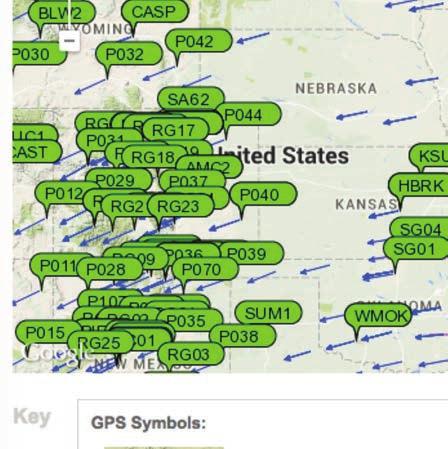
5 EarthScope PBO GPS Network


6 GPS: 1100 Continuous Plate Boundary Observatory Instruments 5 Laser Strainmeters 74 Borehole Strainmeters and 78 Borehole Seismometers 26 Shallow Borehole Tiltmeters 6


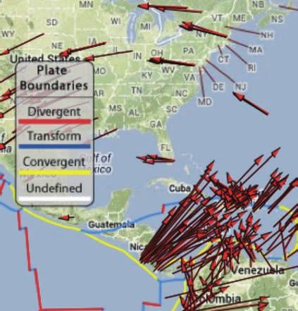
7 Plate motions from GPS using a stable North America reference frame


8 Plate motions from another perspective:! world reference frame


9 LiDAR looking below the trees Open Topography:

10 Western US in 3D Courtesy: Parul Morin, National Center for Earthsurface Dynamics Data Repository [retrieved on 08 March 2015]
11 Education & Community Engagement! Training! Technical short courses, educational workshops, evaluation, new delivery methods! Education Materials! Curriculum development (Strain module, GETSI project [NSF-TUES], existing learning materials! Communications! Website, outreach materials, social media, conferences! Workforce Development! RESESS, RESESS Alumni network, Science Workshop mentoring


 and Berardino")
12 !Tutorials & How to s!lessons!student worksheets!animations!how to download data $ Based on time series inversion algorithms of Lundgren et al. (J. Geophys. Res., 2001) and Berardino et al. (IEEE, 2002). Learning Materials


13 UNAVCO Highlights, and Snapshots reading literacy with science


14 More UNAVCO & PBO Science


15 Social Media $ $ $$ $ $ $$ $ $ $$ $#%?+7,,F$$$$ GC9H+/$


16 Exhibits


17 GPS Spotlights


18 Data for Educators for resources you can %?4;94+3$

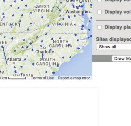
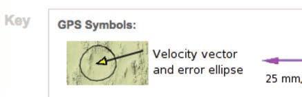
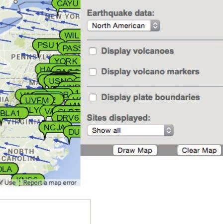
19 Use Data Tools 25 mm/yr Data Source: UNAVCO Plate Boundary Observatory: North American Reference Frame UNAVCO GPS Velocity Viewer 19

20 GPS Velocity Viewer Data source: Global Strain Rate Map Project ; Reference Frame: No Net Rotation UNAVCO GPS Velocity Viewer:


21 Comparing Plate Movement GSRM Project GPS Data


22 Jules Verne & EarthScope Voyager Jr. Seismic Hazard Map Velocity Vectors


23 UNAVCO & PBO supported science Plate movement!earthquakes!volcanoes!glacial movements and isostatic adjustment!hydrologic changes!atmospheric water vapor 23


24 Study & Apply! Geodesy & Measuring Gravity Geodesy is the science of! measuring Earth s size, orientation, NASA GRACE And Map showing variations in the strength of the gravitational force over the surface of the Earth Blue = less gravity Red = more gravity 24
25 Anatomy of a High-precision! Permanent GPS Station MB"$%&1+&&%$9&39'+$,)$',5+$ 6,&*5+&1$3,@9'@>$%H%?8+'$9&1,$ 18+$:/,*&'$C918$7/%?+3N$$ 34)&.')*-+0,/)5+6'(7)&.')(&"1+,) 5+6'(N$ ",@%/$.%&+@$),/$.,C+/$ KO*9.5+&1$+&?@,3*/+$$! MB"$/+?+9;+/$! B,C+/P7%H+/9+3$!2,55*&9?%4,&3P$/%'9,P$5,'+5$!Q%1%$31,/%:+P$5+5,/>$ 25


26 Introduction: GPS Basics! Four satellite signals are needed to locate the receiver in 3D space.! The fourth satellite is also used for time accuracy.! Position can be calculated within to a millimeter.!++'3$:/,*&'$?,&1/,@$%&'$ 45+$O*%@91>


27 Demonstration! Pinpoint Location With GPS How to demonstrate this: /watch? feature=player_e mbedded&v=s_c eimjo5pc#!


28 One satellite, the GPS could be anywhere on the edge of the sphere. One way to find your location! 4 intersecting spheres 3 satellites: spheres intersect in 2 places. Two satellites, GPS could be on the circle where spheres intersect. 4 satellites, spheres intersect in one place.
29 8.",9):+0;) K'*?%4,&$S%1-$*&%;?,N,/:$ 8H.RPPCCCN*&%;?,N,/:P$ $ #,@@,C$D!(E2<$,&$$TTTTTTTTT$ $ $ $$ $ $ $ $ $ $ $$#%?+7,,F$$$$GC9H+/$


30 Websites shown during demonstration Learn more about how GPS works and the science learned through research GPS Spotlight: PBO H2O:


31 Websites shown during demonstration See the ground and forests with LiDAR Many places to get LiDAR! Open Topography: New York: Maine: Vermont: New Hampshire:
32 About GRACE

33 Measuring the Plates Move UNAVCO Plate Boundary Observatory Data
EXPLORE PLATE TECTONICS & MORE THROUGH GPS DATA. Shelley Olds, UNAVCO April 12, 2018 NGSS Webinar
 EXPLORE PLATE TECTONICS & MORE THROUGH GPS DATA Shelley Olds, UNAVCO April 12, 2018 NGSS Webinar Today s Outline Central question: How do we know the tectonic plates are still moving? -- What evidence
Measuring Plate Motion with GPS
 Measuring Plate Motion with GPS Student worksheet Roger Groom, Cate Fox-Lent, and Shelley Olds, UNAVCO. Revised by Nancy West and Kathleen Alexander. Under our feet is a dynamic, ever-changing Earth. Pressure
GPS Strain & Earthquakes Unit 3: Finding location and velocity data for PBO GPS stations
 GPS Strain & Earthquakes Unit 3: Finding location and velocity data for PBO GPS stations Original activity by Vince Cronin (Baylor University). Revisions by Beth Pratt-Sitaula (UNAVCO). Analyzing the velocities
The EarthScope Geophysical Observatories. Slides courtesy Bob Woodward, Incorporated Research Institutions for Seismology (IRIS)
") The EarthScope Geophysical Observatories Slides courtesy Bob Woodward, Incorporated Research Institutions for Seismology (IRIS) 1 EarthScope Project Study the four dimensional structure and evolution of
The EarthScope Geophysical Observatories Slides courtesy Bob Woodward, Incorporated Research Institutions for Seismology (IRIS) 1 EarthScope Project Study the four dimensional structure and evolution of
Plate Boundary Observatory the first five years
 www.earthscope.org Plate Boundary Observatory the first five years Plate Boundary Observatory A Continental-Scale, Integrated Geodetic By the Numbers (2003 2008) Installed 891 permanent Global Positioning
Seismic Recording Station AZ_PFO Summary Report
 Seismic Recording Station AZ_PFO Summary Report Thank you for hosting station AZ_PFO on your property. We hope that you find the enclosed report interesting. Your station is one of the 2000 USArray seismic
Exploring Plate Motion and Deformation in California with GPS
 Exploring Plate Motion and Deformation in California with GPS Cate Fox-Lent, UNAVCO Master Teacher; Andy Newman, Georgia Institute of Technology; Shelley Olds, UNAVCO; revised by Nancy West Part 1: Analyze
Seismic Recording Station TA_109C Summary Report
 Seismic Recording Station TA_109C Summary Report Thank you for hosting station TA_109C on your property. We hope that you find the enclosed report interesting. Your station is one of the 2000 USArray seismic
Introduction to Strain and Borehole Strainmeter Data
 Introduction to Strain and Borehole Strainmeter Data Evelyn Roeloffs U. S. Geological Survey Earthquake Science Center March 28, 2016 Evelyn Roeloffs, USGS ESC Strainmeters: Introduction March 28, 2016
UNAVCO COMMUNITY AND FACILITY PROPOSAL GEODESY ADVANCING EARTH SCIENCE RESEARCH
 2008-2012 UNAVCO COMMUNITY AND FACILITY PROPOSAL GEODESY ADVANCING EARTH SCIENCE RESEARCH About the Cover The cover shows the three primary activities of the UNAVCO facility requested in this proposal.
Education and Outreach:
 EarthScope National Meeting - Pre-meeting workshops May 12, 2009: (Update: April 8, 2009) Education and Outreach: Interpretive Methods for Scientists: Communicating EarthScope to the Public Interpretation
the IRIS Consortium Collaborative, Multi-user Facilities for Research and Education Briefing NSF Business Systems Review September 9, 2008
 the IRIS Consortium Collaborative, Multi-user Facilities for Research and Education Briefing NSF Business Systems Review September 9, 2008 A facilities program for collection and distribution of seismological
Principles of the Global Positioning System Lecture 24
 12.540 Principles of the Global Positioning System Lecture 24 Prof. Thomas Herring http://geoweb.mit.edu/~tah/12.540 OVERVIEW Examination of results from Earthscope Reference frame definition: SNARF High-rate
TEGAM s Connection to the EarthScope Project
 TEGAM s Connection to the EarthScope Project Introduction The EarthScope Project is an undertaking funded by the National Science Foundation in partnership with the United States Geological Survey and
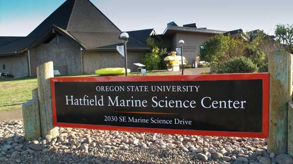
Cascadia EarthScope Earthquake and Tsunami Education Program (CEETEP)
") Cascadia EarthScope Earthquake and Tsunami Education Program (CEETEP) Workshop for Teachers, Interpreters, and Emergency Management Educators August 12-15, 2013 Guin Library Seminar Room OSU Hatfield Marine
Cascadia EarthScope Earthquake and Tsunami Education Program (CEETEP) Workshop for Teachers, Interpreters, and Emergency Management Educators August 12-15, 2013 Guin Library Seminar Room OSU Hatfield Marine
Lab 9: Satellite Geodesy (35 points)
") Lab 9: Satellite Geodesy (35 points) Here you will work with GPS Time Series data to explore plate motion and deformation in California. This lab modifies an exercise found here: http://www.unavco.org:8080/cws/pbonucleus/draftresources/sanandreas/
Lab 9: Satellite Geodesy (35 points) Here you will work with GPS Time Series data to explore plate motion and deformation in California. This lab modifies an exercise found here: http://www.unavco.org:8080/cws/pbonucleus/draftresources/sanandreas/
A new era of geodetic big data - challenges and opportunities Tim Wright (COMET, University of
 A new era of geodetic big data - challenges and opportunities Tim Wright (COMET, University of Leeds) S @NERC_COMET N A New Era of Geodetic Big Data? GEM Strain Rate Model 17,491 GNSS sites included in
Software requirements * :
 Title: Product Type: Developer: Target audience: Format: Software requirements * : Using GRACE to evaluate change in Greenland s ice sheet Part I: Download, import and map GRACE data Part II: View and
Yellowstone Hotspot Component of the Plate Boundary Observatory
 Yellowstone Hotspot Component of the Plate Boundary Observatory (Investigators: Smith, Thatcher, Meertens, Humphreys, Dzurisin, Oldow Co-Investigators: Christiansen, Doss, Schwartz, Machette, Wong, Olig,
Interferometric Synthetic Aperture Radar (InSAR) and GGOS. Andrea Donnellan NASA/JPL February 21, 2007
 and GGOS. Andrea Donnellan NASA/JPL February 21, 2007") Interferometric Synthetic Aperture Radar (InSAR) and GGOS Andrea Donnellan NASA/JPL February 21, 2007 Sources for Science Objectives Fourth component of EarthScope Involvement: NSF, NASA, USGS, Universities
Interferometric Synthetic Aperture Radar (InSAR) and GGOS Andrea Donnellan NASA/JPL February 21, 2007 Sources for Science Objectives Fourth component of EarthScope Involvement: NSF, NASA, USGS, Universities
Measuring Water Resources Unit 3: Groundwater withdrawal and fluctuations in the height of Earth's surface student exercise
 Measuring Water Resources Unit 3: Groundwater withdrawal and fluctuations in the height of Earth's surface student exercise Eric Small (University of Colorado) and Bruce Douglas (Indiana University) Complete
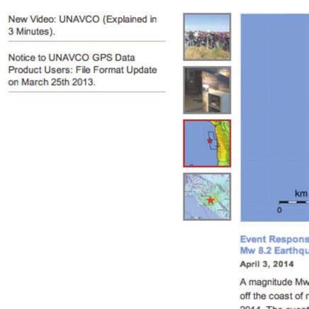
Magnitude 8.2 NORTHWEST OF IQUIQUE, CHILE
 An 8.2-magnitude earthquake struck off the coast of northern Chile, generating a local tsunami. The USGS reported the earthquake was centered 95 km (59 miles) northwest of Iquique at a depth of 20.1km
Breakout Session III Evolving landscapes and global environmental change
 Breakout Session III Evolving landscapes and global environmental change 1. Hydrology and critical zone imaging 2. Glaciology: Instrumenting glaciers and ice sheets 3. Polar networks and glacial isostatic
Education Toolkits for the 21 rst Century Ecological Research
 Education Toolkits for the 21 rst Century Ecological Research NEON s University Education / Outreach Program Leah A. Wasser, Sr. Science Educator, Remote Sensing Ecologist Wendy Gram, Liz Goehring National
Your Advisor Said, Get the GPS Data and Plot it. Jeff Freymueller Geophysical University of Alaska Fairbanks
 Your Advisor Said, Get the GPS Data and Plot it Jeff Freymueller Geophysical Ins@tute University of Alaska Fairbanks Actual GPS Data GPS Data are phase and pseudorange data that measure distances to satellites.
The Scientific Value of High-Rate, Low-Latency GPS Data
 The Scientific Value of High-Rate, Low-Latency GPS Data by W.C. Hammond, B.A. Brooks, R. Bürgmann, T. Heaton, M. Jackson, A.R. Lowry, S. Anandakrishnan Recent and ongoing technical advances in uses of
Using GNSS Signals to Measure Soil Moisture, Vegetation Water Content, Snow Depth, Water Levels, Permafrost, and Volcanic Plumes
 Using GNSS Signals to Measure Soil Moisture, Vegetation Water Content, Snow Depth, Water Levels, Permafrost, and Volcanic Plumes Kristine M. Larson Department of Aerospace Engineering Sciences University
ERS Track 98 SAR Data and InSAR Pairs Used in the Analysis
 ERS Track 98 SAR Data and InSAR Pairs Used in the Analysis Date 1 Date 2 Date 1 Date 2 Date 1 Date 2 Date 1 Date 2 7/17/1992 6/19/2000 7/17/1992 7/2/1993 9/10/1993 10/28/1996 9/3/1995 10/18/1999 9/25/1992
CEETEP Related Digital Resources
 CEETEP Related Digital Resources The resources on the CEETEP DVD and USB drive include many items developed by or in collaboration with other organizations. Here we overview some of the partner and related
Nebraska Geospatial Extension Program Karisa Vlasek Geospatial Extension & Research Specialist
 Nebraska Geospatial Extension Program Karisa Vlasek Geospatial Extension & Research Specialist A NASA Nebraska Space Grant Consortium & EPSCoR Sponsored Research Endeavor Nebraska s Geospatial Extension
LECTURE #11: Volcanoes: Monitoring & Mitigation
 GEOL 0820 Ramsey Natural Disasters Spring, 2018 LECTURE #11: Volcanoes: Monitoring & Mitigation Date: 15 February 2018 I. What is volcanic monitoring? the continuous collection of one or more data sources
New satellite mission for improving the Terrestrial Reference Frame: means and impacts
 Fourth Swarm science meeting and geodetic missions workshop ESA, 20-24 March 2017, Banff, Alberta, Canada New satellite mission for improving the Terrestrial Reference Frame: means and impacts Richard
Newtonian Noise J A N H A R M S & V U K M A N D I C J O I N T E T / C E S Y M P O S I U M F L O R E N C E,
 Newtonian Noise 1 J A N H A R M S & V U K M A N D I C J O I N T E T / C E S Y M P O S I U M F L O R E N C E, 2 0 1 6 2 Modelling Seismic NN 3 Density fluctuation inside medium Surface displacement Seismic
Determining strain graphically
 Nancy West, Beth Pratt-Sitaula, and Shelley Olds, expanded from work by Vince Cronin, Baylor University and Anne Egger, Central Washington University. We have ample evidence that Earth deforms deformed
GEORED Project: GNSS Geodesy Network for Geodynamics Research in Colombia, South America. Héctor Mora-Páez
 GEORED Project: GNSS Geodesy Network for Geodynamics Research in Colombia, South America. Héctor Mora-Páez Colombian Geological Survey UNAVCO SCIENCE MEETING Feb 27 March 1, 2012 Boulder, CO, TECTONIC
The Global Geodetic Observing System (GGOS) of the International Association of Geodesy, IAG
 of the International Association of Geodesy, IAG") The Global Geodetic Observing System (GGOS) of the International Association of Geodesy, IAG Hans-Peter Plag (1), Markus Rothacher (2), Richard Gross (3), Srinivas Bettadpur (4) (1) Nevada Bureau of Mines
The Global Geodetic Observing System (GGOS) of the International Association of Geodesy, IAG Hans-Peter Plag (1), Markus Rothacher (2), Richard Gross (3), Srinivas Bettadpur (4) (1) Nevada Bureau of Mines
Operational Aspects of GNSS CORS What is a GNSS CORS system used for?
 Please insert a picture (Insert, Picture, from file). Size according to grey field (10 cm x 25.4 cm). Scale picture: highlight, pull corner point Cut picture: highlight, choose the cutting icon from the
How Do We Know Where an Earthquake Originated? Teacher's Guide
 How Do We Know Where an Earthquake Originated? Teacher's Guide Standard Addressed: Grades 6-8: Scientific Inquiry 1 B/1, 2 Mathematical Inquiry 2 C/2 Technology and Science 3 A/2 Processes that shape the
SCIGN science report & GPS fault slip sensors
 SCIGN science report & GPS fault slip sensors Kenneth W. Hudnut USGS, Pasadena, CA UJNR Earthquake Research Panel Meeting Morioka, Japan Nov. 6-7, 2002 GPS is now vital to earthquake monitoring (array
GPS measurements of current crustal movements along the Gulf of Suez, Egypt.
 GPS measurements of current crustal movements along the Gulf of Suez, Egypt. Presented By Nadia Abo-Ali Assistant Researcher At National Research Institute of Astronomy and Geophysics (NRIAG), Helwan,
The Geohazard Supersites and Natural Laboratories (GSNL).
.") The Geohazard Supersites and Natural Laboratories (GSNL). Falk Amelung, University of Miami Mike Poland, Hawaii Volcano Observatory Scott Baker, U of Miami, Unavco Outline: Overview over GSNL (Phase 2)
The Geohazard Supersites and Natural Laboratories (GSNL). Falk Amelung, University of Miami Mike Poland, Hawaii Volcano Observatory Scott Baker, U of Miami, Unavco Outline: Overview over GSNL (Phase 2)
Activity Cascadia GPS (gumdrop GPS)
") Activity Cascadia GPS (gumdrop GPS) Students build gumdrop global positioning system (GPS) stations while learning how GPS satellites can determine locations of points on Earth s surface. Students then
Activity Cascadia GPS (gumdrop GPS) Students build gumdrop global positioning system (GPS) stations while learning how GPS satellites can determine locations of points on Earth s surface. Students then
Plate Boundary Observatory Working Group for the Central and Northern San Andreas Fault System PBO-WG-CNSA
 Plate Boundary Observatory Working Group for the Central and Northern San Andreas Fault System PBO-WG-CNSA Introduction Our proposal focuses on the San Andreas fault system in central and northern California.
From Global to National Geodetic Reference Frames: how are they connected and why are they needed?
 From Global to National Geodetic Reference Frames: how are they connected and why are they needed? Zuheir ALTAMIMI Institut National de l Information Géographique et Forestière, France Vice-President,
Project Helps Constrain Continental Dynamics and Seismic Hazards
 Eos, Vol. 86, No. 4 1, 11 October 2005 Project Helps Constrain Continental Dynamics and Seismic Hazards PAGES 3 8 3, 3 8 7 The Global Strain Rate Map project II-8, initi ated in 1998 by the International
Geodetic Observing Systems: tools in observing the Glacial Isostatic Adjustment. Markku Poutanen Finnish Geodetic Institute
 Geodetic Observing Systems: tools in observing the Glacial Isostatic Adjustment Markku Poutanen Finnish Geodetic Institute Glacial Isostatic Adjustment Land uplift is just one consequence of the physical
Depth-dependent slip regime on the plate interface revealed from slow earthquake activities in the Nankai subduction zone
 2010/10/11-14 Earthscope Workshop Depth-dependent slip regime on the plate interface revealed from slow earthquake activities in the Nankai subduction zone Kazushige Obara, ERI, Univ. Tokyo Recurrence
Atmospheric Moisture, Precipitation, and Weather Systems
 Atmospheric Moisture, Precipitation, and Weather Systems 6 Chapter Overview The atmosphere is a complex system, sometimes described as chaotic in nature. In this chapter we examine one of the principal
GGOS The Global Geodetic Observing System of the International Association of Geodesy
 GGOS The Global Geodetic Observing System of the International Association of Geodesy Presented at the FIG Working Week 2017, May 29 - June 2, 2017 in Helsinki, Finland Hansjörg Kutterer BKG, Germany Content
INFERRING LARGE-SCALE TERRESTRIAL WATER STORAGE THROUGH GRACE AND GPS DATA FUSION
 INFERRING LARGE-SCALE TERRESTRIAL WATER STORAGE THROUGH GRACE AND GPS DATA FUSION CODY RUDE 1, JUSTIN LI 1, MICHAEL GOWANLOCK 1, THOMAS HERRING 2, AND VICTOR PANKRATIUS 1 1 MIT HAYSTACK OBSERVATORY 2 MIT
Geographic Information Systems class # 1 February 19, Coordinate reference systems in GIS: geodetic coordinates
 Geographic Information Systems class # 1 February 19, 2013 Coordinate reference systems in GIS: geodetic coordinates Manuel Campagnolo ISA Manuel Campagnolo (ISA) GIS/SIG 2012 2013 February 19, 2013 1
Inquiry: Sumatran earthquakes with GPS Earth Science Education
 Inquiry: Sumatran earthquakes with GPS Earth Science Education www.earthobservatory.sg Preparation: Before doing this investigation, complete two introductory investigations using GPS data from UNAVCO
CIRCULAR MOTION AND SHM : Higher Level Long Questions.
 CIRCULAR MOTION AND SHM : Higher Level Long Questions. ***ALL QUESTIONS ARE HIGHER LEVEL**** Circular Motion 2012 Question 12 (a) (Higher Level ) An Olympic hammer thrower swings a mass of 7.26 kg at the
Meeting at a Glance May 2018
 Meeting at a Glance 14 18 May 2018 Monday 14 May Tuesday 15 May Wednesday 16 May Thursday 17 May Friday 18 May 7:30 a.m. 3:30 p.m. Board of Directors Meeting Orchid C Noon 4 p.m. Workshop: Getting Published
GRAVIMETRIC MAP OF CHILE. Services Mining and Engineering Geophysics Instituto Geográfico Militar
 GRAVIMETRIC MAP OF CHILE Araneda M., Rivas L., Avendaño M, Sottolichio G., Rubio W. Services Mining and Engineering Geophysics segmi@netexpress.cl) Instituto Geográfico Militar (lrivas@igm.cl) Abstract
Windward Community College. Center for Aerospace Education
 Windward Community College Center for Aerospace Education Center for Aerospace Education manages 4 aerospace facilities: Imaginarium Lanihuli Observatory Aerospace Exploration Lab NASA Flight Training
Cascadia EarthScope Earthquake and Tsunami Education Program (CEETEP) Bob Butler University of Portland
 Bob Butler University of Portland") Cascadia EarthScope Earthquake and Tsunami Education Program (CEETEP) Bob Butler University of Portland Nancee Hunter & Bob Lillie Oregon State University Beth Pratt-Sitaula Central Washington University
Cascadia EarthScope Earthquake and Tsunami Education Program (CEETEP) Bob Butler University of Portland Nancee Hunter & Bob Lillie Oregon State University Beth Pratt-Sitaula Central Washington University
Forces in the Earth s crust
 EARTHQUAKES Forces in the Earth s crust How does stress in the crust change Earth s surface? Where are faults usually found, and why do they form? What land features result from the forces of plate movement?
GPS strain analysis examples Instructor notes
 GPS strain analysis examples Instructor notes Compiled by Phil Resor (Wesleyan University) This document presents several examples of GPS station triplets for different tectonic environments. These examples
Syllabus and Course Description Geophysical Geodesy Fall 2013 GPH 411/611
 Syllabus and Course Description Geophysical Geodesy Fall 2013 GPH 411/611 Course Location: LME 422 Course Time: Tuesday & Thursday 12:00-1:15 Units: 3 Instructor Name: Bill Hammond Office Location: SEM
REFERENCE: The Blue Planet An Introduction to Earth System Science. Brian J. Skinner and Barbara W. Murck (2011) Third Edition. John Wiley and Sons
 Third Edition. John Wiley and Sons") REFERENCE: The Blue Planet An Introduction to Earth System Science. Brian J. Skinner and Barbara W. Murck (2011) Third Edition. John Wiley and Sons Inc. It is the solid Earth composed primarily of: :
REFERENCE: The Blue Planet An Introduction to Earth System Science. Brian J. Skinner and Barbara W. Murck (2011) Third Edition. John Wiley and Sons Inc. It is the solid Earth composed primarily of: :
Integration of space and terrestrial techniques to study crustal deformation. Examples in northeastern Italy
 Integration of space and terrestrial techniques to study crustal deformation. Examples in northeastern Italy Susanna Zerbini Dipartimento di Fisica, University of Bologna, Italy IAG-IASPEI Joint Capacity
Module 1, Investigation 3: Predicting Eruptions
 Module 1, Investigation 3: Predicting Eruptions Introduction Welcome! Volcanoes are either "active" or "extinct". Active means that the volcano has erupted during the past 10,000 years. It can also mean
Magnitude 7.8 SCOTIA SEA
 A magnitude 7.8 earthquake has occurred in the South Orkney Island region in the Scotia Sea. According to the USGS, this earthquake is the latest in a series of moderate-tolarge earthquakes to strike this
Monitoring Volcanoes. An introduction to monitoring techniques. Name: Class: Date:
 Monitoring Volcanoes An introduction to monitoring techniques Name: Class: Date: Aims To understand how volcanoes are monitored in order to predict when they will erupt To understand the importance of
SCHOOL PROGRAM GUIDE KINDERGARTEN GRADE School Program Lead Sponsor
 SCHOOL PROGRAM GUIDE KINDERGARTEN GRADE 12 2018 2019 School Program Lead Sponsor GRADES K 3 HANDS-ON WORKSHOPS Students work together on engaging STEAM activities. Monday to Friday 11 a.m., 12 p.m., 1
GIS Visualization: A Library s Pursuit Towards Creative and Innovative Research
 GIS Visualization: A Library s Pursuit Towards Creative and Innovative Research Justin B. Sorensen J. Willard Marriott Library University of Utah justin.sorensen@utah.edu Abstract As emerging technologies
Processes that Shape the Earth
 Grade 8 Science, Quarter 4, Unit 4.1 Processes that Shape the Earth Overview Number of instructional days: 20 (1 day = 45 minutes) Content to be learned Explain the role of differential heating and convection
September 5, 2012 M 7.6 Costa Rica Earthquake
 September 5, 2012 M 7.6 Costa Rica Earthquake On September 5, 2012, a Magnitude 7.6 earthquake occurred in the Nicoya Peninsula of northwestern Costa Rica, along a locked segment of the subduction boundary
AuScope infrastructure providing a telescope looking into the Australian continent. Dr. Tim Rawling, CEO, AuScope
 AuScope infrastructure providing a telescope looking into the Australian continent. Dr. Tim Rawling, CEO, AuScope 01 Introduction 03 eresearch Strategy 02 Infrastructure 04 Future Programs Opportunities
Gravity data reduction
 Gravity data reduction REDUCTION: raw data à gravity anomaly data Temporal corrections tides and instrument drift Spatial corrections latitude and elevation GRS67 = gravity variation with latitude at sea
The Importance of Cultural Contexts in Climate Education
 The Importance of Cultural Contexts in Climate Education Kathryn Berry Bertram, Ph.D., University of Alaska Fairbanks Geophysical Institute Education Director Climate education for indigenous students
Developing Cross-cultural Education Programs
 Developing Cross-cultural Education Programs Kathy Bertram Director, Education Outreach Office Geophysical Institute University of Alaska Fairbanks Communicating Science in Native Cultures Alaska Native
Seismicity in Pennsylvania and the Pennsylvania State Seismic Network (PASEIS)
") Seismicity in Pennsylvania and the Pennsylvania State Seismic Network (PASEIS) Andy Nyblade Department of Geosciences, Penn State University May 19, 2017 Shale Network Workshop Introduction Review of historic
Seismicity in Pennsylvania and the Pennsylvania State Seismic Network (PASEIS) Andy Nyblade Department of Geosciences, Penn State University May 19, 2017 Shale Network Workshop Introduction Review of historic
Using UNAVCO Real-Time CORS Data, a No-Cost Positioning Resource
 Using UNAVCO Real-Time CORS Data, a No-Cost Positioning Resource By: Mark Silver, ms@igage.com, +1-801-412-0011 Date: 19 August 2014 UNAVCO is a non-profit consortium of Universities that coordinates the
The maps in this resource can be freely modified and reproduced in the classroom only.
 Teacher's Notes In this activity, students work collaboratively to explore sections of old and new maps. By closely examining these documents, students learn to see maps as more than just tools for locating
PBO Strainmeters and Tiltmeters
 PBO Strainmeters and Tiltmeters Duncan Carr Agnew IGPP/Scr ipps Institution UC San Diego > Basic Principles We want to to measure how the Earth moves or defor ms. To do this, our measuring systems (instruments)
Active Fault Observation and Research on Earthquake Potential in Taiwan. Chao-Chung Lin Central Geological Survey, Taiwan
 Active Fault Observation and Research on Earthquake Potential in Taiwan Chao-Chung Lin Central Geological Survey, Taiwan Outline Plate tectonic setting and historical earthquake disasters of Taiwan Geologic
Magnitude 6.9 GULF OF CALIFORNIA
 A pair of strong earthquakes struck off the coast of Mexico early Thursday only minutes apart. The magnitude 6.9 and 6.2 were centered about 85 miles northeast of Guerrero Negro in the Mexican state of
Bob Lillie Certified Interpretive Trainer Emeritus Professor of Geosciences Oregon State University
 Cascadia EarthScope Earthquake and Tsunami Education Program (CEETEP) Aberdeen, Washington Workshop August 11-14, 2014 Elk River Estuary, Washington Exchange of Pedagogies: Working Together in Coastal
If you are looking for the book Geodetic Deformation Monitoring: From Geophysical to Engineering Roles: IAG Symposium Jaén, Spain, March 7-19,2005
 Geodetic Deformation Monitoring: From Geophysical To Engineering Roles: IAG Symposium Jaén, Spain, March 7-19,2005 (International Association Of Geodesy Symposia) READ ONLINE If you are looking for the
International Centre for Global Earth Models (ICGEM)
") International Centre for Global Earth Models (ICGEM) 1 International Centre for Global Earth Models (ICGEM) http://icgem.gfz-potsdam.de/ Franz Barthelmes, Elmas Sinem Ince, Sven Reißland Overview The ICGEM
International Centre for Global Earth Models (ICGEM) 1 International Centre for Global Earth Models (ICGEM) http://icgem.gfz-potsdam.de/ Franz Barthelmes, Elmas Sinem Ince, Sven Reißland Overview The ICGEM
Positioning the Pacific: NOAA s Geospatial Activities. Juliana Blackwell, Director NOAA s National Geodetic Survey March 6, 2012
 Positioning the Pacific: NOAA s Geospatial Activities Juliana Blackwell, Director NOAA s National Geodetic Survey March 6, 2012 A Common Problem of the Early 19 th Century 1807 President Thomas Jefferson
MAGMATIC, ERUPTIVE AND TECTONIC PROCESSES IN THE ALEUTIAN ARC, ALASKA
 MAGMATIC, ERUPTIVE AND TECTONIC PROCESSES IN THE ALEUTIAN ARC, ALASKA Introduction The Aleutian Arc contains roughly ten percent of the world s active volcanoes. Hardly a year goes by without a major eruption
Unit 6: GPS-Strain Module Final Research Project
 Unit 6: GPS-Strain Module Final Research Project Written by Vince Cronin (Baylor University) with modifications by Beth Pratt-Sitaula (UNAVCO) Assignment Identify a set of three adjacent PBO GPS sites
& OUTREACH PROGRAM PLAN
 A N UN P RE C E D E N T E D FO R IN E D U C AT I O N & OUTREACH PROGRAM PLAN O P P O RT U N I TY E D U CAT I O N T H E E A RT H A N D O U T REA CH S CI E N C E S Submitted by the EarthScope E&O Committee.
NESEC NEWS. Published by the Northeast States Emergency Consortium. Wakefield, Massachusetts
 Published by the Northeast States Emergency Consortium Wakefield, Massachusetts Connecticut Maine Massachusetts New Hampshire New Jersey New York Rhode Island Vermont Volume 21 Issue 4 www.nesec.org Winter
Update on the assimilation of GPS RO data at NCEP
 Update on the assimilation of GPS RO data at NCEP Lidia Cucurull National Oceanic and Atmospheric Administration (NOAA) & Joint Center for Satellite Data Assimilation (JCSDA) Fourth FORMOSAT-3/COSMIC Data
Global & National Geodesy, GNSS Surveying & CORS Infrastructure
 Global & National Geodesy, GNSS Surveying & CORS Infrastructure Chris Rizos School of Surveying & Spatial Information Systems University of New South Wales, Sydney, Australia President-elect, International
LAB: PLATE TECTONICS GOAL: Calculate rates of plate movement
 Name LAB: PLATE TECTONICS GOAL: Calculate rates of plate movement Rates of plate movement are calculated by measuring the distance rocks have moved since they formed. Rates are expressed in cm per year
MEETING MINUTES WCFLAMS Chapter. Teach the Teachers Workshop
 DATE: March 23, 2010 MEETING MINUTES WCFLAMS Chapter Teach the Teachers Workshop LOCATION: University of South Florida C.W. Bill Young Auditorium Tampa, FL 33620 PRESENTATIONS: The Teach the Teachers Workshop
Magnitude 7.5 NEW BRITAIN REGION, PAPUA NEW GUINEA
 A magnitude 7.5 earthquake struck off the eastern coast of Papua New Guinea on Tuesday, approximately 130 km (81 mi) southsouthwest of Kokopo at a depth of 42 km (26.1 mi). There are reports of some structural
Magnitude 7.0 N of ANCHORAGE, ALASKA
 A magnitude 7.0 earthquake occurred just before 8:30 am local time 8 miles north of Anchorage at a depth of 40.9 km (25.4 miles). There are reports of major infrastructure damage and damage to many homes
The February 28, 2001 Nisqually earthquake: GPS Geodesy and quantifying seismic hazard.
 The February 28, 2001 Nisqually earthquake: GPS Geodesy and quantifying seismic hazard. Testimony prepared for: Subcommittee on Research, The Committee on Science United States House of Representatives
DETERMINATION OF THE STATION COORDINATES FOR QUALITY CONTROL OF THE SATELLITE LASER RANGING DATA S.
 DETERMINATION OF THE STATION COORDINATES FOR QUALITY CONTROL OF THE SATELLITE LASER RANGING DATA S. Schillak Space Research Centre of the Polish Academy of Sciences. Astrogeodynamic Observatory, Borowiec
Mapping rainfall and flooding
 Mapping rainfall and flooding BY DAVID WALBERT Although Hurricane Floyd was the biggest storm of 1999 and the one most remembered, eastern North Carolina was hit by three hurricanes in a six-week period
Section 19.1: Forces Within Earth Section 19.2: Seismic Waves and Earth s Interior Section 19.3: Measuring and Locating.
 CH Earthquakes Section 19.1: Forces Within Earth Section 19.2: Seismic Waves and Earth s Interior Section 19.3: Measuring and Locating Earthquakes Section 19.4: Earthquakes and Society Section 19.1 Forces
ES 104 # 5 EARTHQUAKES:
 ES 104 Laboratory # 5 EARTHQUAKES: Epicenter Determination, Seismic Waves, and Hazards Introduction Earthquakes are vibrations of Earth caused by large releases of energy that accompany volcanic eruptions,
CEETEP Cascadia EarthScope Earthquake and Tsunami Education Program
 CEETEP Cascadia EarthScope Earthquake and Tsunami Education Program Professional development workshops for coastal teachers, interpreters, and emergency management educators. Bob Butler University of Portland
Weather and Climate: Satellite Meteorology
 LIVE INTERACTIVE LEARNING @ YOUR DESKTOP Weather and Climate: Satellite Meteorology Presented by: Rudo Kashiri April 4, 2013 6:30 p.m. 8:00 p.m. Eastern time 1 2 http://learningcenter.nsta.org NSTA Learning