AuScope infrastructure providing a telescope looking into the Australian continent. Dr. Tim Rawling, CEO, AuScope
|
|
|
- Doreen Scarlett Parks
- 5 years ago
- Views:
Transcription
1 AuScope infrastructure providing a telescope looking into the Australian continent. Dr. Tim Rawling, CEO, AuScope
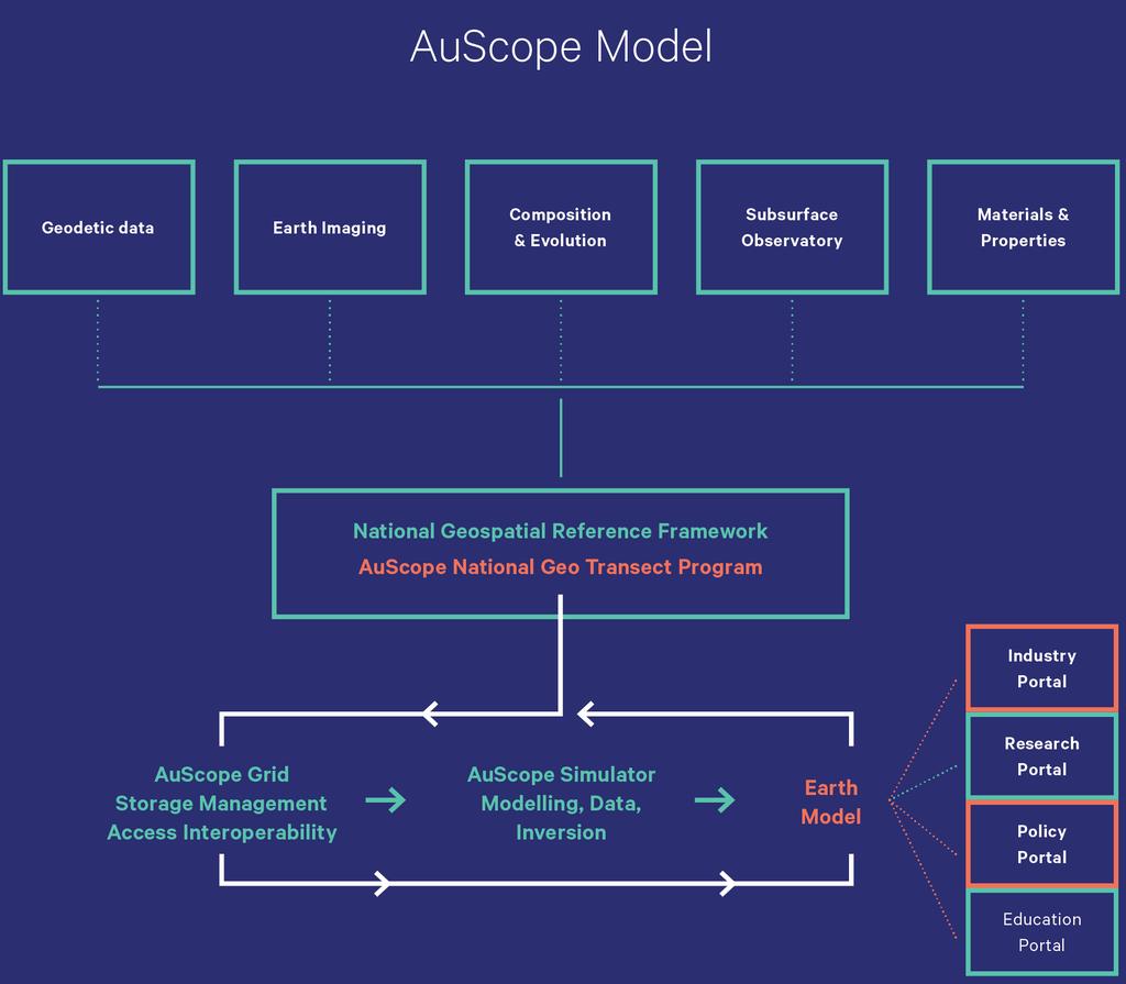
2 01 Introduction 03 eresearch Strategy 02 Infrastructure 04 Future Programs Opportunities Contents
3 Introduction What is AuScope?
![Australian Context Image: By Reto Stöckl / NASA Goddard Space Flight Center [Public domain], via Wikimedia Commons. Australia is old, cold and cratonised.](/docs-images/89/100963256/images/4-2.jpg "Minerals search space is maturing, and exploration is being forced deeper under transported cover.")
4 Australian Context Image: By Reto Stöckl / NASA Goddard Space Flight Center [Public domain], via Wikimedia Commons. Australia is old, cold and cratonised. Minerals search space is maturing, and exploration is being forced deeper under transported cover. Introduction 44 4 MinEx Consulting (Richard Schodde) 2015, Exploration trends, inds and issues in Australia. Excludes satellite deposits in existing camps and bulk mineral discoveries.


5 Australian Context Large, fast moving plate Complex active plate boundaries and geoid geometries Highly stressed crust mostly in compression and underestimated seismic hazard Introduction 55 5


6 AuScope History Introduction Established in 2006 to implement an Earth and Geospatial Science Infrastructure program National Collaborative Research Infrastructure Strategy (NCRIS) Program Structure and Evolution of the Australian Continent $75M Commonwealth investment $34M cash and $128M in-kind co-investment from partners 66 6
 to drive: Innovative Australian scientific research Support scientific investigations in government and industry")
7 AuScope Purpose Introduction To create universal access to earth and geospatial research infrastructure (equipment, data, analytics) to drive: Innovative Australian scientific research Support scientific investigations in government and industry 77 7


8 Introduction 88 8
9 Introduction
10 Infrastructure Programs Programs


11 Geospatial Program Programs Responsible for acquisition and deployment of VLBI telescopes, GNSS sites, absolute gravity measurement, GPS calibration robots and satellite laser ranging sites throughout Australia Provides data that underpins Australia s dynamic geodetic framework: observing movement, change and deformation in the Australian plate

12 Earth Imaging Program Works with GA and state GSO s to support deployment of AusArray Passive Seismic and AusLAMP MT Arrays Manages an OBS research fleet Supports the national reflection seismic transect program Programs

13 Earth Imaging Program: Magnetotellurics Programs Australian Lithospheric Architecture Magnetotelluric Project (AusLAMP) program Collaboration with UA and GA National long-period MT data at approx. 2,800 sites across Australia to map electrical conductivity of the continent in three dimensions

14 Earth Composition Program Programs Provides operational support for a suite of world-class analytical infrastructure Infrastructure is located at Curtin University, University of Melbourne and Macquarie University and includes LIMS, SHRIMP, Fission Track and TerraneChron access. Provides researchers with geochronological and geochemical data necessary to understand the formation mechanisms and evolution of the Australian continent

15 Programs
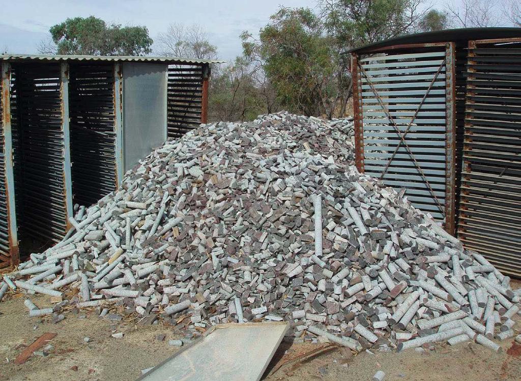
16 Materials & Properties Program: National Virtual Core Library (NVCL) Annually, ~$600M is spent on drilling in Australian, but too often core is only partially logged, and then discarded This program overcomes this massive underutilisation of core for research and thus, new mineral discoveries Programs


17 Materials & Properties Program: National Virtual Core Library (NVCL) Programs Facilitates collection, storage and discovery of high quality, semi-quantitative hyperspectral mineralogical data from drill core Over 10,000 km of historical core logged from across Australia 10s of research papers produced in


18 Outreach: Seismometers in Schools (AuSIS) Image: Dr. Michelle Salmon, ANU Deployment of research-quality instruments into Australian secondary schools Programs Provides resources for student engagement in geoscience Simultaneously provides data to researchers about Australian crustal movements
19 eresearch & Data Strategy eresearch & Data


20 IGSN and LIMS IGSN is a unique alphanumeric code assigned to specimens and related sampling features to ensure their unique identification GA, CSIRO and Curtn/AuScope IGSN - Lims


21 Simulation, Analysis & Modelling (eresearch) Program A toolkit for 3D and 4D modelling, simulation analysis and data mining for geoscientists in Australia New data assimilation workflows ensure models are constrained by observational data collected with other AuScope infrastructure Programs Image: Tectonic plate subduction simulation at Monash University. Provided by Prof. Louis Moresi and Owen Kaluza.

22 Gplates and Underworld provide tools that allow geoscientists to explore the evolution of mineral and energy systems and their hosts through deep time Programs
 provide access to data collected or generated by both")

23 AuScope Grid Programs The AuScope Portal, the Virtual Geophysical Laboratory (VGL) and the Data Enhanced Virtual Laboratory (DeVL) provide access to data collected or generated by both AuScope and collaborating partners Data is freely accessibly, findable and interoperable New development with DeVL will ensure data is FAIR Findable, Accessible, Interoperable and Reusable

24 AuScope Grid & Research Codes Cloud enablement of research codes such as Underworld2, escript and gplates drives collaboration Also supports tertiary teaching and student use Programs

25 SISSVoc eresearch & Data Provides semantic web-based vocabularies RESTful interface Allows humans and machine readable views Significant contribution to the domain Mostly through work led by Simon Cox with NeAT, then AuScope funding Used by Australian Government and other high profile groups

26 SISSPid eresearch & Data Persistent Identifier Service Used by CSIRO, BoM, GA and internationally Initially under NeAT but then furthered by AuScope Grid and ANDS ASRDC project
 provides registry for workflows that can be human and machine discoverable and executable on the fly Collaboration 27 27")
27 Virtual Laboratories eresearch & Data Initially linking data to computation VLs now instrumental in orchestrating workflows Scientific Software Solution Centre (SSSC) provides registry for workflows that can be human and machine discoverable and executable on the fly Collaboration

28 eresearch & Data
29 Collaboration Future Opportunities
30 National Innovation & Science Agenda Collaboration $1.5B commitment over 10 years Highlighted 9 x research infrastructure areas that will transform Australian research and deliver returns for community and industry partners Inward focussed Earth monitoring and exploration, potential development of inward-looking telescopes

31 National Innovation & Science Agenda Collaboration Enhanced capability for AuScope to include new Earth monitoring data, and utilise new remotely sensed data and visualise data Key requirement for generational shift in technology resources and interconnectivity of all facilities Including establishing a virtual laboratory network to enable large data share (incl. digitised collections) and improve real-time communication


32 Future Focus Future Investment NISA and the NRIR provides an enormous opportunity for AuScope and the geoscience community as a whole Possibility for significant new investment in national programs in support of research initiatives such as UNCOVER Building a Downward looking earth telescope AuScope has developed two investment roadmaps over the last 5 years (available from our website) AuScope is seeking community feedback regarding investment priorities over the coming decade We will be hosting a workshop immediately after the AGCC conference in Adelaide in October and we welcome your input at this event
33 Thank you Connect with AuScope auscope.org.au auscope auscope unimelb.edu.au
THE AUSTRALIAN EARTH OBSERVING SYSTEM (AEOS)
") THE AUSTRALIAN EARTH OBSERVING SYSTEM (AEOS) Strategic Overview 2016 AuScope is the national provider of integrated research infrastructure to realise the collective potential of Australian Earth and Geospatial
THE AUSTRALIAN EARTH OBSERVING SYSTEM (AEOS) Strategic Overview 2016 AuScope is the national provider of integrated research infrastructure to realise the collective potential of Australian Earth and Geospatial
Australian Earth Science Research Spatial Information Infrastructure
 AN ORGANISATION FOR A NATIONAL EARTH SCIENCE INFRASTRUCTURE PROGRAM Australian Earth Science Research Spatial Information Infrastructure Dr Robert Woodcock AuScope Grid - Director Outline Why build an
AuScope Highlights
 AuScope 2012-2013 Highlights building world class Earth and Geospatial infrastructure for Australia s future 2 Overview 4 NCRIS Program AuScope Grid and Interoperability 6 National Virtual Core Library
AuScope Infrastructure Program evaluation of impacts. A Lateral Economics report for AuScope Limited
 AuScope Infrastructure Program evaluation of impacts A Lateral Economics report for AuScope Limited AuScope Infrastructure Program evaluation of impacts A Lateral Economics report for AuScope Limited August
SPECCHIO for Australia: taking spectroscopy data from the sensor to discovery for the Australian remote sensing community
 University of Wollongong Research Online Faculty of Science, Medicine and Health - Papers Faculty of Science, Medicine and Health 2013 SPECCHIO for Australia: taking spectroscopy data from the sensor to
Strategic Resources Exploration Program. Queensland Exploration Council Technical Forum 28 Feb 2018 Tony Knight - Chief Government Geologist
 Strategic Resources Exploration Program Queensland Exploration Council Technical Forum 28 Feb 2018 Tony Knight - Chief Government Geologist Strategic resources exploration program What is it? Application
For personal use only
 25 th June 2018 ASX MARKET RELEASE ASX: AMG AUSMEX COMMENCES MT SURVEY OVER LARGE CONDUCTIVE STRUCTURE BELOW BURRA, SA Ø AUSMEX (AMG) AND UNIVERSITY OF ADELAIDE (UoA) IN COLLABORATION WITH OTHERS (SEE
Next Generation Australian Datum. Permanent Committee on Geodesy, ICSM
 Next Generation Australian Datum Permanent Committee on Geodesy, ICSM 2 Presentation: Next Generation Australian Datum Trends in the geospatial sector The Geocentric Datum of Australia 1994 (GDA94) Progress
What are the social, technical, environmental and economic benefits and opportunities of accessing and sharing geodetic data?
 What are the social, technical, environmental and economic benefits and opportunities of accessing and sharing geodetic data? Graeme Blick Group Manager Positioning and Resilience Land Information New
Deep Crustal Seismic Reflection Profiling: Australia
 Deep Crustal Seismic Reflection Profiling: Australia 1978-2015 B.L.N. Kennett (Research School of Earth Sciences, The Australian National University) E. Saygin (Centre for Energy Geoscience, School of
Mapping the basement of South Australia: BACK TO BASICS
 Mapping the basement of South Australia: BACK TO BASICS David Giles Centre for Mineral Exploration Under Cover School of Earth and Environmental Sciences The University of Adelaide The accountants perception
Integrating information, HPC and organisations for Earth Science innovation
 Integrating information, HPC and organisations for Earth Science innovation Dr Robert Woodcock Exploration and Mining Lesley Wyborn Geoscience Australia The Components of Auscope AuScope Infrastructure
Challenges and opportunities for under-cover exploration in Australia
 Challenges and opportunities for under-cover exploration in Australia Richard Schodde Managing Director, Adjunct Professor, Centre for Exploration Targeting, UWA UNCOVER Summit 2014 31st March 2014 Adelaide
For personal use only
 ASX Announcement ASX: ERM ABN: 53 117 086 745 June 18, 2015 Seismic Survey to underpin future gold discoveries at Tennant Creek First application of seismic geophysics to the Tennant Creek Mineral Field
Stick to your books: The contribution of geoscience to the minerals value chain. Anthony Reid. Geological Survey of South Australia
 Stick to your books: The contribution of geoscience to the minerals value chain Anthony Reid Geological Survey of South Australia AusIMM/GSA lunch, 17 May 2018 Demand and supply It all starts with the
The Time is Right to Commit to Use International Standards. Empowering Australia with Spatial Information
 The Time is Right to Commit to Use International Standards Empowering Australia with Spatial Information OUTLINE Energy Industry Metadata Standards Initiative ISO 19115 Revision Australian initiatives
The Canadian Ceoscience Knowledge Network. - A Collaborative Effort for Unified Access to Ceoscience Data
 The Canadian Ceoscience Knowledge Network - A Collaborative Effort for Unified Access to Ceoscience Data The Canadian Geoscience Knowledge Network A Collaborative Effort for Unified Access to Geoscience
Action Plan Spatial Industry Transformation and Growth Agenda
 2026 Spatial Industry Transformation and Growth Agenda Action Plan Summary of key initiatives and roadmap to drive the future of the Australian spatial sector 29 March 2017 For Release Foreword by Assistant
9. Density Structure. The Australian Continent: A Geophysical Synthesis Density Structure
 84 The Australian Continent: A Geophysical Synthesis Density Structure 9. Density Structure Although the primary focus for the development of the AuSREM model was the creation of 3-D seismic wavespeed
Breakout Session III Evolving landscapes and global environmental change
 Breakout Session III Evolving landscapes and global environmental change 1. Hydrology and critical zone imaging 2. Glaciology: Instrumenting glaciers and ice sheets 3. Polar networks and glacial isostatic
Building a Virtual Geological Observatory
 DERCAP Workshop 2009 Building a Virtual Geological Observatory Dietmar Müller School of Geosciences, University of Sydney Virtual Observatories... have revolutionized astronomy by giving people anywhere
the IRIS Consortium Collaborative, Multi-user Facilities for Research and Education Briefing NSF Business Systems Review September 9, 2008
 the IRIS Consortium Collaborative, Multi-user Facilities for Research and Education Briefing NSF Business Systems Review September 9, 2008 A facilities program for collection and distribution of seismological
Mount Stromlo Gravity Station Gravimetry at the ANU
 ANU COLLEGE OF SCIENCE RESEARCH SCHOOL OF EARTH SCIENCES Canberra ACT 0200 Australia Mount Stromlo Gravity Station Gravimetry at the ANU Background Terrestrial observing has been conducted at Mount Stromlo
An Industry Perspective. Bryn Fosburgh Vice President Trimble
 An Industry Perspective Bryn Fosburgh Vice President Trimble Who are we? Professionals & Consultants Geospatial Professionals working at or with: AEC Consultants Transportation Departments Construction
Around the world with Underworld - distributed development and collaboration in computational geodynamics
 School of Geosciences Around the world with Underworld - distributed development and collaboration in computational geodynamics Louis Moresi Katie Cooper Auscope SAM Wendy Mason 1 What is AuScope / AuScope
Working Group 1. Geodetic Reference Frame. Activity Report. for. The UN-GGIM-AP Plenary Meeting
 Regional Committee of United Nations Global Geospatial Information Management for Asia and the Pacific (UN-GGIM-AP) Established by a United Nations Resolution Working Group 1 Geodetic Reference Frame Activity
Report for 15th PCGIAP Meeting at 18th UNRCC-AP Working Group 1 Regional Geodesy
 Report for 15th PCGIAP Meeting at 18th UNRCC-AP Working Group 1 Regional Geodesy Chairman Shigeru Matsuzaka, Japan - shigeru@gsi.go.jp Vice Chairman Prof. Pengfei Cheng, China - chengpf@casm.ac.cn John
Lunar Discovery and Exploration program
 Lunar Discovery and Exploration program Space Policy Directive-1 (December 11, 2017) amends the National Space Policy to include the following paragraph: Lead an innovative and sustainable program of exploration
What s the problem? A Modern Odyssey in Search of Relevance. The search for relevance. Some current drivers for new services. Some Major Applications
 A Modern Odyssey in Search of Relevance FIG Working Week, Athens, 24 May 2004 Paul Kelly ANZLIC Executive Director The search for relevance 1. New expectations for spatial services 2. Are we ready to meet
Our Planet, Australia s Future
 NATIONAL COMMITTEE FOR EARTH SCIENCES AUSTRALIAN ACADEMY OF SCIENCE OCTOBER 2018 Companion report to Our Planet, Australia s Future A decade of transition in Geoscience Background information and extended
The Australian Integrated Marine Observing System: Present and Future Possibilities
 The Australian Integrated Marine Observing System: Present and Future Possibilities Roger Proctor, IMOS/eMII emarine Information Infrastructure IMOS is supported by the Australian Government through the
Current Research Trends from an Australian Perspective. Dr Philip Collier Research Director
 Current Research Trends from an Australian Perspective Dr Philip Collier Research Director Growth in the spatial sector. 11% pa in the Global Navigation Satellite System market 2010-2020 300% growth in
InnovaRig - an Instrument for a European Geothermal Drilling Program
 InnovaRig - an Instrument for a European Geothermal Drilling Program Lothar Wohlgemuth, Bernhard Prevedel, and Ernst Huenges GeoForschungsZentrum Potsdam GeoForschungsZentrum Potsdam Member of the Helmholtz
The Afar Rift Consortium
 The Afar Rift Consortium University of Bristol University of Oxford University of Cambridge British Geological Survey University of Rochester University of Auckland, NZ Opportunistic programme following
KINGSTON RESOURCES LIMITED
 KINGSTON RESOURCES LIMITED ASX:KSN ACN 009 148 529 9 April 2015 Company Announcements Office Australian Securities Exchange Six Mile Hill Exploration Update - April 2015 Highlights: Detailed 3D gravity
A Modern Odyssey in Search of Relevance
 A Modern Odyssey in Search of Relevance Paul KELLY, Australia Key words: Capacity building, GIM, spatial data infrastructure. SUMMARY A modern country has a voracious appetite for spatial information.
Investigator Resources Limited
 Investigator Resources Limited Advancing the Paris silver project & offering new copper-gold discovery opportunities SOUTH AUSTRALIAN EXPLORERS WITH THE RIGHT TRACK RECORD WELL FUNDED & DRILLING South
Quarter Summary Slide Pack
 Quarter 4 2014 Summary Slide Pack DET CRC Quarter 4 2014 Slide Pack Contents Slide #1 Slide #2 Slide #3 Slide #4 Slide #5 Slides #6-11 Slides #12-22 Cover Slide This Slide Contents & Information DET CRC
Interferometric Synthetic Aperture Radar (InSAR) and GGOS. Andrea Donnellan NASA/JPL February 21, 2007
 and GGOS. Andrea Donnellan NASA/JPL February 21, 2007") Interferometric Synthetic Aperture Radar (InSAR) and GGOS Andrea Donnellan NASA/JPL February 21, 2007 Sources for Science Objectives Fourth component of EarthScope Involvement: NSF, NASA, USGS, Universities
Interferometric Synthetic Aperture Radar (InSAR) and GGOS Andrea Donnellan NASA/JPL February 21, 2007 Sources for Science Objectives Fourth component of EarthScope Involvement: NSF, NASA, USGS, Universities
Subject: Science Course Title: Earth & Grade Level(s): 8th
: 8th") Teacher: Mike Valenti School: Mt. Tabor Middle School Subject: Science Course Title: Earth & Grade Level(s): 8th Space Is high school credit an option for this course? Yes X No Prerequisites: None Course
Teacher: Mike Valenti School: Mt. Tabor Middle School Subject: Science Course Title: Earth & Grade Level(s): 8th Space Is high school credit an option for this course? Yes X No Prerequisites: None Course
The Structure of the Earth and Plate Tectonics
 The Structure of the Earth and Plate Tectonics Agree or Disagree? 1. The Earth if made up of 4 different layers. 2. The crust (where we live) can be made of either less dense continental crust or the more
Mineral Resources Research and Training at the University of Adelaide
 Mineral Resources Research and Training at the University of Adelaide David Giles School of Earth and Environmental Sciences Centre for Mineral Exploration Under Cover March 2007 Copyright 2007 The University
Case Study of Australia
 Case Study of Australia John Dawson, Geoscience Australia 1 Australia s Geodetic eco-system Geocentric Coordinates Observing Infrastructure Height Datum Geoid Models Tools Services Standards 2 Australia
The Global Shift to Undercover Exploration - How fast? How effective?
 The Global Shift to Undercover Exploration - How fast? How effective? Richard Schodde Managing Director, Adjunct Professor, University of Western Australia Society of Economic Geologists 214 Conference
Originally published as:
 Originally published as: Henstock, T., McNeill, L., Dean, S., Barton, P., Tilmann, F., Rietbrock, A., Robinson, D., Gulick, S., Austin, J., Djajadihardja, Y., Natawidjaja, D., Permana, H., Bonneville,
Geoscience Australia Report on Cal/Val Activities
 Medhavy Thankappan Geoscience Australia Agency Report I Berlin May 6-8, 2015 Outline 1. Calibration / validation at Geoscience Australia Corner reflector infrastructure for SAR calibration (for information)
Data Origin. Ron van Lammeren CGI-GIRS 0910
 Data Origin Ron van Lammeren CGI-GIRS 0910 How to obtain geodata? Geo data initiative Executive Order 12906, "Coordinating Geographic Data Acquisition and Access: The National Spatial Data Infrastructure,"
GEON: Geosciences Network
 GEON: Geosciences Network A Research Project to Create Cyberinfrastructure for the Geosciences Dogan Seber San Diego Supercomputer Center, University of California, San Diego Objectives An in-depth look
Data Origin. How to obtain geodata? Ron van Lammeren CGI-GIRS 0910
 Data Origin How to obtain geodata? Ron van Lammeren CGI-GIRS 0910 Spatial Data interest Improvement of policy making. ± 90% of all information used by government has spatial characteristics SPATIAL INFORMATION
Prospectors Making NEW Discoveries
 Prospectors Making NEW Discoveries Hans Smit Minerals North 2012 Burns Lake, British Columbia May 2012 BC Needs New Discoveries BC mines and most advanced mineral projects were found decades ago To ensure
Colin Bray, OSi CEO. Collaboration to develop a data platform for geospatial and statistical information in Ireland
 Colin Bray, OSi CEO Collaboration to develop a data platform for geospatial and statistical information in Ireland Organisations Ireland s National Mapping Agency Established in 1824 Operates under the
The Index to Marine and Lacustrine Geological Samples
 The Index to Marine and Lacustrine Geological Samples Community access to common information on sample collections Kelly J. Stroker 1, Jennifer Jencks 2 1 Cooperative Institute for Research in Environmental
Passive Seismic for mapping and estimating the depth of paleochannels
 Passive Seismic for mapping and estimating the depth of paleochannels Matt Owers ASEG Passive Seismic Workshop Adelaide, August 2016 Mapping paleochannels in order to: 1. Find specific mineral deposits
Management of Public Geoscience Data
 Management of Public Geoscience Data A Guide to Australian Practice GIRAF Workshop Ian Satchwell September 2013 Management of Public Geoscience Data - A Guide to Australian Practice Based on a paper by
Research trends from down under
 Research trends from down under Dr Zaffar Sadiq Mohamed-Ghouse Manager- Business, Research Development &International Relations Australia New Zealand Cooperative Research Centre for Spatial Information
National Atlas of Groundwater Dependent Ecosystems (GDE)
") National Atlas of Groundwater Dependent Ecosystems (GDE) Dr. Zaffar Sadiq Mohamed-Ghouse Executive Consultant & Practice Head-Spatial SKM, Australia zsadiq@globalskm.com Geospatial World Forum 2013, Rotterdam,
National Atlas of Groundwater Dependent Ecosystems (GDE) Dr. Zaffar Sadiq Mohamed-Ghouse Executive Consultant & Practice Head-Spatial SKM, Australia zsadiq@globalskm.com Geospatial World Forum 2013, Rotterdam,
Spatial Data Availability Energizes Florida s Citizens
 NASCIO 2016 Recognition Awards Nomination Spatial Data Availability Energizes Florida s Citizens State of Florida Agency for State Technology & Department of Environmental Protection Category: ICT Innovations
For personal use only
 ACN 097 088 689 ASX Announcement 1 EXPLORATION SUCCESS CONTINUES AT RAVENSWOOD RC drilling targeting shallow portions of Welcome breccia returns a number of significant new results including: 7m @ 7.84g/t
The Tectonic Setting of New Zealand
 The Tectonic Setting of New Zealand we are here Subduction-driven tectonics The New Zealand continent Papua New Guinea Australia 3,000,000 sq km micro-continent back-arc basin trench volcanism faults accretionary
Visualising time-series data with the Australian Hydrological Geospatial Fabric & the Geofabric Sample Toolbox
 Visualising time-series data with the Australian Hydrological Geospatial Fabric & the Geofabric Sample Toolbox Darren G Smith #Locate15, Thursday 12 th of March 2015 Presentation outline Quick background
Euro-VO. F. Genova, Interoperability meeting, 9 November 2009
 Euro-VO F. Genova, Interoperability meeting, 9 November 2009 European astronomy A rich landscape including the two European Agencies, ESA and ESO, and national programmes Several of the founding parents
XXIII CONGRESS OF ISPRS RESOLUTIONS
 XXIII CONGRESS OF ISPRS RESOLUTIONS General Resolutions Resolution 0: Thanks to the Czech Society commends: To congratulate The Czech Society, its president and the Congress Director Lena Halounová, the
Open Data meets Big Data
 Open Data meets Big Data Max Craglia, Sven Schade, Anders Friis European Commission Joint Research Centre www.jrc.ec.europa.eu Serving society Stimulating innovation Supporting legislation JRC is Technical
Semi-Dynamic Datum of Indonesia
 Technical Seminar Reference Frame in Practice, Semi-Dynamic Datum of Indonesia H.Z. Abidin, A.B. Wijanarto, S.T. Wibowo, Susilo, J. Efendi Geospatial Information Agency, Indonesia (BIG) Sponsors: Page
New Progress of SinoProbe:
 New Progress of SinoProbe: Deep Exploration in China, 2008-2012 Shuwen DONG, Tingdong LI, et al. Chinese Academy of Geological Sciences Beijing 100037 China Background of Deep Exploration in World USA
The influence of short wavelength variations in viscosity on subduction dynamics
 1 Introduction Deformation within the earth, driven by mantle convection due primarily to cooling and subduction of oceanic lithosphere, is expressed at every length scale in various geophysical observations.
The Theory of Continental Drift. Continental Drift Discovery
 The Theory of Continental Drift Continental Drift Discovery The World ALFRED WEGENER THEORY OF CONTINENTAL DRIFT Found evidence for PANGAEA and proposed the theory of continental drift. Continental Drift
the map Redrawing Donald Hobern takes a look at the challenges of managing biodiversity data [ Feature ]
![the map Redrawing Donald Hobern takes a look at the challenges of managing biodiversity data [ Feature ]](/thumbs/82/86628837.jpg "the map Redrawing Donald Hobern takes a look at the challenges of managing biodiversity data [ Feature ]") Redrawing the map Donald Hobern takes a look at the challenges of managing biodiversity data 46 Volume 12 > Number 9 > 2008 www.asiabiotech.com Cicadetta sp., Canberra, Australia, December 2007 Photograph
Redrawing the map Donald Hobern takes a look at the challenges of managing biodiversity data 46 Volume 12 > Number 9 > 2008 www.asiabiotech.com Cicadetta sp., Canberra, Australia, December 2007 Photograph
ECONOMIC AND SOCIAL COUNCIL
 UNITED NATIONS E/CONF.102/3 ECONOMIC AND SOCIAL COUNCIL Nineteenth United Nations Regional Cartographic Conference for Asia and the Pacific Bangkok, 29 October 1 November 2012 Item 4 of the provisional
Basics of GIS reviewed
 Basics of GIS reviewed Martin Breunig Karlsruhe Institute of Technology martin.breunig@kit.edu GEODETIC INSTITUTE, DEPARTMENT OF CIVIL ENGINEERING, GEO AND ENVIRONMENTAL SCIENCES, CHAIR IN GEOINFORMATICS
Future Global Data-processing and Forecasting System (GDPFS)
") Future Global Data-processing and Forecasting System (GDPFS) Enabling Seamless Activities from Research to Operations to Service (R2O2S) for the benefits of Members Michel Jean President of CBS The GDPFS
Future Global Data-processing and Forecasting System (GDPFS) Enabling Seamless Activities from Research to Operations to Service (R2O2S) for the benefits of Members Michel Jean President of CBS The GDPFS
Innovation in Mineral Exploration: advances in mineral exploration research Joe Cucuzza
 Innovation in Mineral Exploration: advances in mineral exploration research Joe Cucuzza PROMETIA Science Seminar December 2016 Berlin This presentation Why do we need innovation in mineral exploration?
The EarthScope Geophysical Observatories. Slides courtesy Bob Woodward, Incorporated Research Institutions for Seismology (IRIS)
") The EarthScope Geophysical Observatories Slides courtesy Bob Woodward, Incorporated Research Institutions for Seismology (IRIS) 1 EarthScope Project Study the four dimensional structure and evolution of
The EarthScope Geophysical Observatories Slides courtesy Bob Woodward, Incorporated Research Institutions for Seismology (IRIS) 1 EarthScope Project Study the four dimensional structure and evolution of
Department of Earth Science and Engineering, Imperial College London. Course Syllabus,
 Department of Earth Science and Engineering, Imperial College London Course Syllabus, 2017-2018 The degree course is structured but flexible; core modules are covered in year 1 and 2, where students may
Integration for Informed Decision Making
 Geospatial and Statistics Policy Intervention: Integration for Informed Decision Making Greg Scott Global Geospatial Information Management United Nations Statistics Division Department of Economic and
Global geophysics and wave propagation
 Global geophysics and wave propagation Reading: Fowler p76 83 Remote sensing Geophysical methods Seismology Gravity and bathymetry Magnetics Heat flow Seismology: Directly samples the physical properties
BURACOPPIN EXPLORATION UPDATE
 BURACOPPIN EXPLORATION UPDATE Exploration program underway at Burracoppin Gold Project in WA 6 December 2018 Airborne EM survey completed over E70/4688 Grant of adjoining E70/5154 significantly increases
GEO-VIII November Geohazard Supersites and Natural Laboratories Progress Report. Document 9
 GEO-VIII 16-17 November 2011 Geohazard Supersites and Natural Laboratories Progress Report Document 9 This document is submitted to GEO-VIII for information. Geohazard Supersites and Natural Laboratories
TEGAM s Connection to the EarthScope Project
 TEGAM s Connection to the EarthScope Project Introduction The EarthScope Project is an undertaking funded by the National Science Foundation in partnership with the United States Geological Survey and
Earthscope in the Northern Rockies Workshop
 Earthscope in the Northern Rockies Workshop Co-conveners: David Foster - University of Florida Paul Mueller - University of Florida David Mogk - Montana State University EarthScope in the Northern Rockies
Ontology Summit Framing the Conversation: Ontologies within Semantic Interoperability Ecosystems
 Ontology Summit 2016 Framing the Conversation: Ontologies within Semantic Interoperability Ecosystems GeoSciences Track: Semantic Interoperability in the GeoSciences Gary Berg-Cross and Ken Baclawski Co-Champions
Advancing Geoscientific Capability. Geological Survey of Finland
 Advancing Geoscientific Capability Geological Survey of Finland GTK in brief The Geological Survey of Finland (GTK) is one of the largest European centres of excellence in assessment, research and the
ADVANTAGES OF GIS-INTEGRATED MARITIME DATA IN THE BLACK SEA REGION FOR MULTIPURPOSE USE
 INTERAGENCY INTERACTION IN CRISIS MANAGEMENT AND DISASTER RESPONSE 2017 ADVANTAGES OF GIS-INTEGRATED MARITIME DATA IN THE BLACK SEA REGION FOR MULTIPURPOSE USE Lyubka Pashova 1, Anna Kortcheva 2, Vasko
Pushing the Standards Edge: Collaborative Testbeds to Accelerate Standards Development and Implementation
 Pushing the Standards Edge: Collaborative Testbeds to Accelerate Standards Development and Implementation Mark E. Reichardt President mreichardt@opengeospatial.org 31 October 2006 2006 Open Geospatial
60% upgrade of Flying Doctor Resource to 104,600 tonnes of contained zinc and lead.
 30 April 2008 60% upgrade of Flying Doctor Resource to 104,600 tonnes of contained zinc and lead. Perilya Limited (ASX: PEM) is pleased to announce a 60% increase in the mineral resource estimate for the
MAKING LOCATION MATTER
 MAKING LOCATION MATTER Action to activate location data for people-centred policy CANBERRA ROUNDTABLE 18 OCTOBER 2017 DISCUSSION NOTES v6.0 Discussion overview and priority actions About the Roundtable
Faatasi Malologa (PGSC Chair) Director Department of Lands & Survey, Tuvalu
 Director Department of Lands & Survey, Tuvalu") Seventh Session of the United Nations Committee of Experts on Global Geospatial Information Management (UN-GGIM) - 31 July -4 August 2017 Faatasi Malologa (PGSC Chair) Director Department of Lands & Survey,
Seventh Session of the United Nations Committee of Experts on Global Geospatial Information Management (UN-GGIM) - 31 July -4 August 2017 Faatasi Malologa (PGSC Chair) Director Department of Lands & Survey,
BHP Billiton Mineral Exploration Perspective Mineral Exploration Imperatives [Key Business Drivers]
![BHP Billiton Mineral Exploration Perspective Mineral Exploration Imperatives [Key Business Drivers]](/thumbs/74/70001151.jpg "BHP Billiton Mineral Exploration Perspective Mineral Exploration Imperatives [Key Business Drivers]") BHP Billiton Mineral Exploration Perspective Mineral Exploration Imperatives [Key Business Drivers] Solid Earth and Environment Grid CANBERRA, July 2003 Liedeke Bosma Chief Geologist Knowledge Management
BHP Billiton Mineral Exploration Perspective Mineral Exploration Imperatives [Key Business Drivers] Solid Earth and Environment Grid CANBERRA, July 2003 Liedeke Bosma Chief Geologist Knowledge Management
Engaging Communities for Prioritising Natural Resource Management and Biodiversity Conservation Actions
 Engaging Communities for Prioritising Natural Resource Management and Biodiversity Conservation Actions Robert Milne and Birgita Hansen Centre for eresearch and Digital Innovation, Federation University
DISTRIBUTED GEOCOMPUTATIONS AND WEB COLLABORATION
 DISTRIBUTED GEOCOMPUTATIONS AND WEB COLLABORATION J. A. Rod Blais Dept. of Geomatics Engineering Pacific Institute for the Mathematical Sciences University of Calgary, Calgary, Alberta T2N 1N4 blais@ucalgary.ca
Predictive Mineral Discovery the Yilgarn gold story.. by Y4-A3-M9-F6 Project Members. predictive mineral discovery Cooperative Research Centre
 Predictive Mineral Discovery the Yilgarn gold story.. by Y4-A3-M9-F6 Project Members Continent Y4-A3-M9-F6 Craton Province Camp-district Deposit SESSION: YILGARN 11:20 Bruce Goleby Y4) Big system big picture:
Introduction to GIS Suchith Anand
 Introduction to GIS Suchith Anand Introduction What is GIS? Spatial Data Models Fundamental GIS Map generalization Applied GIS Future Study links What is a Map? A map is a visual representation of an area
Building a 4-D Weather Data Cube for the NextGen Initial Operating Capability (IOC)
") Building a 4-D Weather Data Cube for the NextGen Initial Operating Capability (IOC) Friends/Partners in Aviation Weather Vision Forum July 15, 2008 Bruce Lambert - DoD Tom Ryan FAA Jason Tuell NWS 1 Overview
Building a 4-D Weather Data Cube for the NextGen Initial Operating Capability (IOC) Friends/Partners in Aviation Weather Vision Forum July 15, 2008 Bruce Lambert - DoD Tom Ryan FAA Jason Tuell NWS 1 Overview
The Atlas of Living Australia
 The Atlas of Living Australia The ALA is a national collaborative research infrastructure supported by the Australian Government. It is led by CSIRO in partnership with the Australian biological community.
Magnus Copper Project exploration update
 ASX ANNOUNCEMENT 30 SEPTEMBER 2011 CODE: ALY BOARD OF DIRECTORS Mr Warwick Davies Non-Executive Chairman Mr Robert Brierley Managing Director Mr John Arbuckle Non-Executive Director Mr Jeffrey Moore Non-Executive
The AMGI project: A Brief Overview
 The AMGI project: A Brief Overview World Bank Group (Energy & Extractives Global Practice) GEEDR Francisco Igualada (figualada@worldbank.org) Presented by Ash Johnson, Geosoft Inc. The AMGI Project: Vision
Exploring the Future of Scientific Research in Antarctica
 ATCM XXXIX- CEP XIX, Santiago, Chile, 2016 SCAR Science Lecture Exploring the Future of Scientific Research in Antarctica Jerónimo López-Martínez Universidad Autónoma de Madrid, Spain President of SCAR
For personal use only
 ASX ANNOUNCEMENT 24 JUNE 2015 APOLLO MINERALS WINS FUNDING GRANT FOR DRILLING AT FRASER RANGE PROJECT HIGHLIGHTS Apollo Minerals awarded $150,000 funding grant for its Fraser Range project The grant was
STATUS OF MARINE SPATIAL DATA INFRASTRUCTURE
 STATUS OF MARINE SPATIAL DATA INFRASTRUCTURE IN PACIFIC ISLAND COUNTRIES 26 th January, 2016 7 th IHO Marine Spatial Data Infrastructure Working Group Meeting Tokyo Sachindra Singh Senior Geospatial Systems
The purpose of this report is to recommend a Geographic Information System (GIS) Strategy for the Town of Richmond Hill.
 Strategy for the Town of Richmond Hill.") Staff Report for Committee of the Whole Meeting Department: Division: Subject: Office of the Chief Administrative Officer Strategic Initiatives SRCAO.18.12 GIS Strategy Purpose: The purpose of this report
Staff Report for Committee of the Whole Meeting Department: Division: Subject: Office of the Chief Administrative Officer Strategic Initiatives SRCAO.18.12 GIS Strategy Purpose: The purpose of this report