Originally published as:
|
|
|
- Nickolas Allison
- 5 years ago
- Views:
Transcription
: Exploring Structural Controls on Sumatran Earthquakes.")
1 Originally published as: Henstock, T., McNeill, L., Dean, S., Barton, P., Tilmann, F., Rietbrock, A., Robinson, D., Gulick, S., Austin, J., Djajadihardja, Y., Natawidjaja, D., Permana, H., Bonneville, A., Lucazeau, F., Weber, M. (2010): Exploring Structural Controls on Sumatran Earthquakes. - Eos, Transactions, American Geophysical Union, 91, 44,
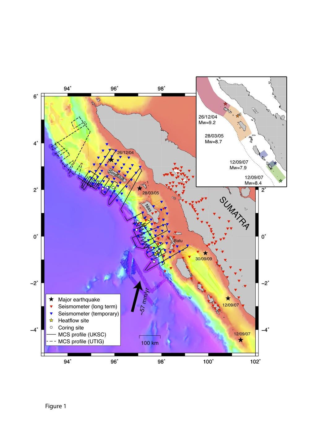
2 Exploring Structural Controls on Great Earthquakes along the Sumatra Subduction Zone T. Henstock 1, L. McNeill 1, S. Dean 1, P. Barton 2, F. Tilmann 2,10, A. Rietbrock 3, D. Robinson 4, S. Gulick 5, J. Austin 5, Y. Djajadihardja 6, D. Natawidjaja 7, H. Permana 7, A. Bonneville 8,9, F. Lucazeau 8, M. Weber 10 1 National Oceanography Centre, Southampton, University of Southampton, UK 2 University of Cambridge, UK 3 University of Liverpool, UK 4 University of Oxford, UK 5 Institute for Geophysics (UTIG), University of Texas, Austin, USA 6 Agency for the Assessment and Application of Technology (BPPT), Indonesia 7 Indonesia Institute for Sciences (LIPI), Indonesia 8 Institut de Physique du Globe de Paris, France 9 Pacific Northwest National Laboratory, USA 10 GFZ Potsdam, Germany A series of linked marine and land studies have recently targeted the Sumatra subduction zone focusing on the boundaries of the 2004 and 2005 plate boundary earthquake ruptures in Indonesia. The collaborative UK-Indonesian-US-French-German research effort aims to image the crustal structure of the margin to examine controls on alongstrike and up-dip earthquake rupture propagation. The project collected extensive marine geophysical, geological, and seismological data across the offshore and onshore parts of the subduction zone of North-Central Sumatra (Figs. 1, 2), and included the largest research vessel exchange program undertaken to date. Using the German vessel RV Sonne, the group acquired 4750 km of multichannel seismic reflection data, and conducted a combined active-source refraction experiment with 95 ocean bottom seismometers (OBS) and 50 stations on land. This experiment was followed by earthquake monitoring over 10 months with up to 60 instruments, including 10 OBS. In addition, the project collected deep-towed sidescan sonar data, multi and piston cores and two heat flow transects as well as along-track multibeam bathymetry, gravity and magnetics data. 140 days of shiptime during 2008 and 2009 were bartered through the Ocean Facilities Exchange Group, primarily funded by the UK Natural Environment Research Council with additional funding from the US National Science Foundation. Additional passive seismic arrays were deployed in the Toba volcano area by GFZ Potsdam, and also farther south in the area of the 2007 plate boundary rupture, in total, monitoring nearly 800 km of plate margin for 6-12 months. In parallel with the onshore-offshore field data collection, the UK-funded project is also developing new methods to refine slip distribution inversions for the earthquakes of 2004, 2005 and The fundamental science objective is to examine how margin architecture and properties control earthquake rupture location and propagation. The main survey spanned two segment boundaries of the subduction zone (Fig. 1): 1) between the 2004 and 2005 ruptures at Simeulue Island; and 2) at the southern limit of the 2005 rupture, adjacent to the short 1935 rupture segment, at the Nias and Batu Islands. These extensive geological
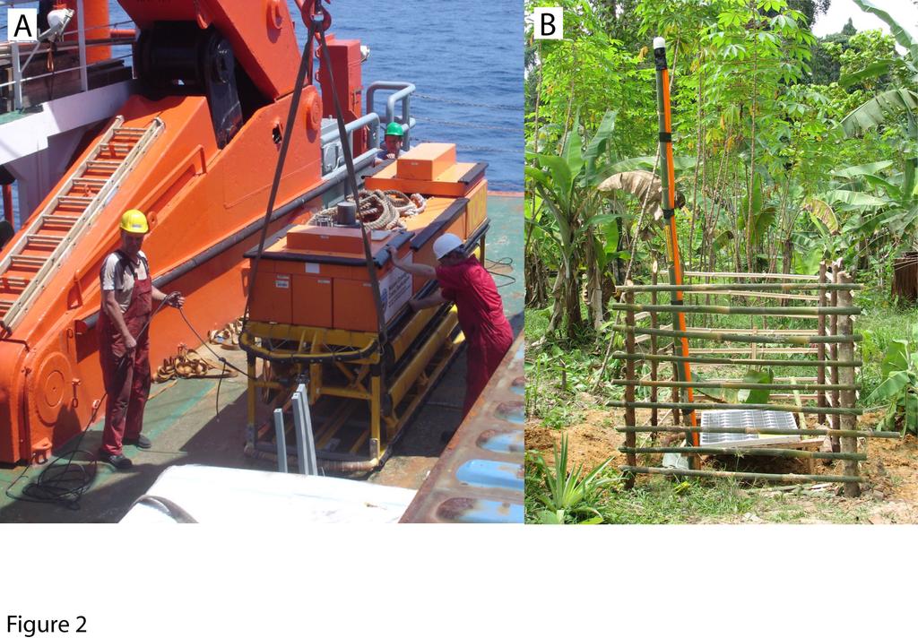
3 and geophysical data examine variations, at a range of scales, in seismicity, forearc deformation, plate boundary properties, lithospheric structure and sedimentary properties and processes. The combined studies are especially relevant given the societal impact of the 2004 earthquake and tsunami and the continued potential for great earthquakes both along this margin and other analogous subduction margins; improved understanding of rupture processes will aid understanding and preparedness for future major subduction zone earthquakes. Data from the passive deployment are already helping to characterize the structural context of the 2009 Padang earthquake, within the subducting Australian Plate. Results are also being used to identify potential borehole sites for an evolving Integrated Ocean Drilling Program proposal, the first to target the Sumatran margin. IODP drilling aims to analyze sediment and fault properties and to monitor post-seismic deformation, to further understand the relationship between physical properties, structure and the earthquake rupture process. To discuss integration of results and future research plans in this region, recent (April, 2010) and future (2011) workshops are bringing together diverse international research groups. Figure 1. Data collected during the combined project, showing offshore tracklines, onshore and offshore instrument/seismometer locations, core sites, and heatflow stations. Tracklines overlain on multibeam bathymetric data from this study overlain on GEBCO low resolution bathymetry. Black stars - major earthquake epicenters. Inset: epicenters and approximate rupture zones of recent large plate boundary earthquakes. UKSC=UK Sumatra Consortium; UTIG=UT Institute for Geophysics. Figure 2. a) Deployment of TOBI deep-towed sidescan sonar offshore Sumatra. b) Example onshore seismometer station during long term deployment. Contact Information: Lisa McNeill, National Oceanography Centre, Southampton, University of Southampton, lcmn@noc.soton.ac.uk
4
5
International Research Collaboration in Indonesia: LIPI as a special reference
 Workshop on Science & Technology Cooperation With Developing Countries on Global Issues. Tokyo, 8 October 2008 International Research Collaboration in Indonesia: LIPI as a special reference Hery Harjono
NUMERICAL SIMULATIONS FOR TSUNAMI FORECASTING AT PADANG CITY USING OFFSHORE TSUNAMI SENSORS
 NUMERICAL SIMULATIONS FOR TSUNAMI FORECASTING AT PADANG CITY USING OFFSHORE TSUNAMI SENSORS Setyoajie Prayoedhie Supervisor: Yushiro FUJII MEE10518 Bunichiro SHIBAZAKI ABSTRACT We conducted numerical simulations
Subduction zone segmentation and controls on earthquake rupture: The 2004 and 2005 Sumatra earthquakes Consortium Participants:
 Subduction zone segmentation: The 2004 and 2005 Sumatran Earthquakes 1 Subduction zone segmentation and controls on earthquake rupture: The 2004 and 2005 Sumatra earthquakes Consortium Participants: University
Building Disaster Resilience Community in Asia: Indonesian perspective
 Workshop C of the 7th Science Council of Asia (SCA) Conference Construction of Secure and Safe Society against Global Changes of Natural Disasters Okinawa, June 14 th, 2007 Building Disaster Resilience
Inaugural UK Broadband OBS Experiments Nicholas Harmon-University of Southampton, UK
 Inaugural UK Broadband OBS Experiments Nicholas Harmon-University of Southampton, UK VOILA Volatile recycling In the Lesser Antilles arc PILAB/EuroLAB Passive Imaging of the Lithosphere Asthenosphere Boundary
overlie the seismogenic zone offshore Costa Rica, making the margin particularly well suited for combined land and ocean geophysical studies (Figure
 Chapter 1 Introduction Historically, highly destructive large magnitude (M w >7.0) underthrusting earthquakes nucleate along the shallow segment of subduction zone megathrust fault, and this region of
Velocity-Interface Structure of the Southwestern Ryukyu Subduction Zone from EW OBS/MCS Data
 Marine Geophysical Researches 22: 265-287, 2001. 2002 Kluwer Academic Publishers. Printed in the Netherlands. Velocity-Interface Structure of the Southwestern Ryukyu Subduction Zone from EW9509-1 OBS/MCS
The Earthquake of Padang, Sumatra of 30 September 2009 scientific information and update
 The Earthquake of Padang, Sumatra of 30 September 2009 scientific information and update 01-October-2009 Christophe Vigny Directeur de recherches at CNRS Laboratoire de Géologie Geoscience Dept. Of ENS,
ERC Advance Grant Trans-Atlan3c Imaging of Lithosphere-Asthenosphere boundary a Story. Sa#sh Singh IPG Paris NTU Singapore
 ERC Advance Grant Trans-Atlan3c Imaging of Lithosphere-Asthenosphere boundary a Story Sa#sh Singh IPG Paris NTU Singapore TransAtlan3cILAB: Summary ERC Advance Grant SubmiFed in 2012 Awarded in 2013, 3.5
Project Report Recording of local earthquakes in Simeulue
 Project Report Recording of local earthquakes in Simeulue Frederik Tilmann September 25, 2006 Abstract From December 12, 2005 to March 22, 2006 we operated a temporary network of 8 stations (Guralp CMG-6T
Diablo Canyon SSHAC Level 3 Study
 1 Diablo Canyon SSHAC Level 3 Study Workshop 1 Summary of SSC Hazard Significant Issues and Data Needed William Lettis November 29 to December 1, 2011 PG&E DCPP SSHAC Study 2 Hosgri Hosgri Location Hosgri
Haiti: Earthquake on January 12, 2010
 Geophysical Hazards and Plate Boundary Processes In Central America, Mexico and the Caribbean Haiti: Earthquake on January 12, 2010 Situation, achievements and perspective. Hotel La Condesa, Costa Rica
Inquiry: Sumatran earthquakes with GPS Earth Science Education
 Inquiry: Sumatran earthquakes with GPS Earth Science Education www.earthobservatory.sg Preparation: Before doing this investigation, complete two introductory investigations using GPS data from UNAVCO
Global geophysics and wave propagation
 Global geophysics and wave propagation Reading: Fowler p76 83 Remote sensing Geophysical methods Seismology Gravity and bathymetry Magnetics Heat flow Seismology: Directly samples the physical properties
Geophysics the use of geology, laboratory & field experiments, mathematics, and instruments to study: Earthquakes and Volcanoes seismometers,
 Geophysics the use of geology, laboratory & field experiments, mathematics, and instruments to study: Earthquakes and Volcanoes seismometers, tiltmeters, EDM, remote sensing, Energy: oil, gas, hydrothermal
Differentiating earthquake tsunamis from other sources; how do we tell the difference?
 Differentiating earthquake tsunamis from other sources; how do we tell the difference? David Tappin (1), Stephan Grilli (2), Jeffrey Harris (2), Timothy Masterlark (3), James Kirby (4), Fengyan Shi Shi
SONGS Seismic Research Projects
 SONGS Seismic Research Projects Energy Division Independent Peer Review Group September 21, 2012 Agenda Background Overview Project Support Permits, Approvals, and Reviews Schedule Use of Advanced Technologies
News Release December 30, 2004 The Science behind the Aceh Earthquake
 News Release December 30, 2004 The Science behind the Aceh Earthquake PASADENA, Calif. - Kerry Sieh, the Robert P. Sharp Professor of Geology at the California Institute of Technology and a member of Caltech's
Mw 7.8, Southwest of Sumatra, Indonesia Wed, 2 March 2016 at 12:49:48 UTC M /03/03
 Earthquake overview AFGHANISTA N PAKISTA N INDIA A moment magnitude (Mw) 7.8 earthquake struck in South West, Indonesia. The epicentre was centered about 800 km West South West of Padang, Sumatra province,
The influence of short wavelength variations in viscosity on subduction dynamics
 1 Introduction Deformation within the earth, driven by mantle convection due primarily to cooling and subduction of oceanic lithosphere, is expressed at every length scale in various geophysical observations.
the IRIS Consortium Collaborative, Multi-user Facilities for Research and Education Briefing NSF Business Systems Review September 9, 2008
 the IRIS Consortium Collaborative, Multi-user Facilities for Research and Education Briefing NSF Business Systems Review September 9, 2008 A facilities program for collection and distribution of seismological
The Structure of the Earth and Plate Tectonics
 The Structure of the Earth and Plate Tectonics Agree or Disagree? 1. The Earth if made up of 4 different layers. 2. The crust (where we live) can be made of either less dense continental crust or the more
APPLICATION OF A PASSIVE TOMOGRAPHY METHOD AND CORRELATION WITH ACTIVE SEISMIC OBSERVATIONS IN THE KYPARISSIAKOS GULF, SOUTHWESTERN HELLENIC ARC
 APPLICATION OF A PASSIVE TOMOGRAPHY METHOD AND CORRELATION WITH ACTIVE SEISMIC OBSERVATIONS IN THE KYPARISSIAKOS GULF, SOUTHWESTERN HELLENIC ARC Tsambas A. 1, Fasoulaka Ch. 2, Papoulia J. 1, Makris J.
Chapter Overview. Bathymetry. Measuring Bathymetry. Measuring Bathymetry
 CHAPTER 3 Marine Provinces Chapter Overview The study of bathymetry determines ocean depths and ocean floor topography. Echo sounding and satellites are efficient bathymetric tools. Most ocean floor features
Announcements. Manganese nodule distribution
 Announcements Lithospheric plates not as brittle as previously thought ESCI 322 Meet in Env. Studies Bldg Rm 60 at 1 PM on Tuesday One week (Thursday): Quiz on Booth 1994 and discussion. (Lots of odd terms
What scientists know and do not know about the big one at Cascadia
 What scientists know and do not know about the big one at Cascadia Kelin Wang Pacific Geoscience Centre, Geological Survey of Canada Natural Resources Canada The Cascadia Subduction Zone M 7.3, 1946 Rupture
OBS Park in Warsaw 2017 European OBS Technical Workshop Paris, France,
 OBS Park in Warsaw 2017 European OBS Technical Workshop Paris, France, 06-07.11.2017 Agenda The Team Collaboration The Legacy Our OBS BalTec KNIPAS Future plans Lessons learned The team Department of the
DETERMINATION OF SLIP DISTRIBUTION OF THE 28 MARCH 2005 NIAS EARTHQUAKE USING JOINT INVERSION OF TSUNAMI WAVEFORM AND GPS DATA
 Synopses of Master Papers Bulletin of IISEE, 47, 115-10, 013 DETERMINATION OF SLIP DISTRIBUTION OF THE 8 MARCH 005 NIAS EARTHQUAKE USING JOINT INVERSION OF TSUNAMI WAVEFORM AND GPS DATA Tatok Yatimantoro
crustal structure experiment beneath Wairarapa - Wellington area: results from SAHKE
 crustal structure experiment beneath Wairarapa - Wellington area: results from SAHKE Tim Stern and SAHKE team* * VUW, GNS, University of Southern California, University of Tokyo(Japan) SAHKE = Seismic
IODP drilling and core storage facilities
 4 IODP drilling and core storage facilities Neville Exon As the knowledge obtainable from ocean drilling is various and extensive, its end-users are similarly various and extensive. Scientific ocean drilling
Indian Ocean Tsunami Warning System: Example from the 12 th September 2007 Tsunami
 Indian Ocean Tsunami Warning System: Example from the 12 th September 2007 Tsunami Charitha Pattiaratchi 1 Professor of Coastal Oceanography, The University of Western Australia Email: chari.pattiaratchi@uwa.edu.au
Status after Six Years
 German-Indonesian Tsunami Early Warning System () Status after Six Years Joern Lauterjung and the -Team Challenge Indonesia Short Early Warning Time Tsunamis are generated at the trench (orange line) Traveltimes
Updating the GEBCO Grid
 Updating the GEBCO Grid PAULINE WEATHERALL, GEBCO DIGITAL ATLAS MANAGER, BRITISH OCEANOGRAPHIC DATA CENTRE (BODC), NATIONAL OCEANOGRAPHY CENTRE (NOC), LIVERPOOL, UK. GEBCO TSCOM and SCRUM meeting, Kuala
Bathymetry Measures the vertical distance from the ocean surface to mountains, valleys, plains, and other sea floor features
 1 2 3 4 5 6 7 8 9 10 11 CHAPTER 3 Marine Provinces Chapter Overview The study of bathymetry determines ocean depths and ocean floor topography. Echo sounding and satellites are efficient bathymetric tools.
7.1 FIJI 1, :57:22 UTC
 A magnitude 7.1 earthquake struck 141 km (88 miles) northeast of Ndoi Island, Fiji, and 313 km (194 mi) west-northwest of Nuku alofa, Tonga according to the US Geological Survey, but there were no reports
JAMSTEC Marine Geophysical Projects for Researches on Subduction Cycles and Deformation
 JAMSTEC Marine Geophysical Projects for Researches on Subduction Cycles and Deformation Shuichi Kodaira Research Center for Earthquake and Tsunami JAMSTEC JAMSTEC Marine Geophysical Projects Motivation:
Investigation of Sumatran Fault Aceh Segment derived from Magnetotelluric Data
 Investigation of Sumatran Fault Aceh Segment derived from Magnetotelluric Data Nurhasan 1, D. Sutarno 1, Y Ogawa 2, F. Kimata 3, D Sugiyanto 4 1 Physics Department, Bandung Institute of Technology, Bandung,
DEEP SAN ANDREAS FAULT BOUNDARY STRUCTURE FROM MARINE MAGNETOTELLURICS A
 DEEP SAN ANDREAS FAULT BOUNDARY STRUCTURE FROM MARINE MAGNETOTELLURICS A proposal submitted to UC Shipfunds for New Horizon and Sproul shiptime Brent Wheelock Kerry Key and Steven Constable SUMMARY Knowledge
The Challenge of Earthquake Disaster in Indonesia. Hery Harjono Indonesian Institute of Sciences
 The Challenge of Earthquake Disaster in Indonesia Hery Harjono Indonesian Institute of Sciences * Presented at the J-Rapid Symposium, Sendai, Japan, March 6-7, 2013 INTRODUCTION The 2004 Giant Sumatran-Andaman
SEISMIC STRUCTURE, GAS-HYDRATE CONCENTRATIONS, AND SLUMPING ALONG THE IODP X311 TRANSECT ON THE N. CASCADIA MARGIN
 Proceedings of the 6th International Conference on Gas Hydrates (ICGH 2008), Vancouver, British Columbia, CANADA, July 6-10, 2008. SEISMIC STRUCTURE, GAS-HYDRATE CONCENTRATIONS, AND SLUMPING ALONG THE
2. Tsunami Source Details
 2. Tsunami Source Details The Northland area faces a range of potential tsunamigenic sources that include several local and distant fault systems and underwater landslides. A NIWA study (Goff et al. 2006)
Cooperating Country Report of GERMANY
 CCOP-47AS/4.1-19 COORDINATING COMMITTEE FOR GEOSCIENCE PROGRAMMES IN EAST AND SOUTHEAST ASIA (CCOP) 47 th CCOP Annual Session 17-21 October 2010 Manado, Indonesia Cooperating Country Report of GERMANY
The Structure of the Earth and Plate Tectonics
 The Structure of the Earth and Plate Tectonics Structure of the Earth The Earth is made up of 4 main layers: Inner Core Outer Core Mantle Crust Crust Mantle Outer core Inner core The Crust This is where
RELOCATION OF LARGE EARTHQUAKES ALONG THE SUMATRAN FAULT AND THEIR FAULT PLANES
 Synopses of Master Papers Bulletin of IISEE, 47, 25-30, 2013 RELOCATION OF LARGE EARTHQUAKES ALONG THE SUMATRAN FAULT AND THEIR FAULT PLANES Biana Rahayu Wulandari MEE11605 Supervisor: Nobuo HURUKAWA ABSTRACT
FOCAL MECHANISMS OF SUBDUCTION ZONE EARTHQUAKES ALONG THE JAVA TRENCH: PRELIMINARY STUDY FOR THE PSHA FOR YOGYAKARTA REGION, INDONESIA
 FOCAL MECHANISMS OF SUBDUCTION ZONE EARTHQUAKES ALONG THE JAVA TRENCH: PRELIMINARY STUDY FOR THE PSHA FOR YOGYAKARTA REGION, INDONESIA Myo Thant 1, Hiroshi Kawase 2, Subagyo Pramumijoyo 3, Heru Hendrayana
Map shows 3 main features of ocean floor
 Map shows 3 main features of ocean floor 2017 Pearson Education, Inc. Chapter 3 Marine Provinces 2017 Pearson Education, Inc. 1 Chapter 3 Overview The study of bathymetry determines ocean depths and ocean
Real time Monitoring System for Earthquakes and Tsunamis (DONET)
") Real time Monitoring System for Earthquakes and Tsunamis (DONET) NankaiTrough Yoshiyuki Kaneda Japan Agency for Marine-Earth Science and Technology (JAMSTEC) POGO@Seoul Presentation 1 Earthquakes in the
Real time Monitoring System for Earthquakes and Tsunamis (DONET) NankaiTrough Yoshiyuki Kaneda Japan Agency for Marine-Earth Science and Technology (JAMSTEC) POGO@Seoul Presentation 1 Earthquakes in the
Volatile recycling in the Lesser Antilles arc
 VoiLA Volatile recycling in the Lesser Antilles arc Processes and Consequences Oct 2015-Sep 2019 Funded by: Université des An-lles de la Guyane University of West Indies Subduction Zone Diversity Slow
Lab 1: Plate Tectonics April 2, 2009
 Name: Lab 1: Plate Tectonics April 2, 2009 Objective: Students will be introduced to the theory of plate tectonics and different styles of plate margins and interactions. Introduction The planet can be
Marine Science and Oceanography
 Marine Science and Oceanography Marine geology- study of the ocean floor Physical oceanography- study of waves, currents, and tides Marine biology study of nature and distribution of marine organisms Chemical
The route towards a new GEBCO grid
 The route towards a new GEBCO grid Pauline Weatherall, GEBCO Digital Atlas Manager British Oceanographic Data Centre (BODC) GEBCO TSCOM/SCRUM meeting, Monaco, October 2012 The route towards a new GEBCO
Sendai Earthquake NE Japan March 11, Some explanatory slides Bob Stern, Dave Scholl, others updated March
 Sendai Earthquake NE Japan March 11, 2011 Some explanatory slides Bob Stern, Dave Scholl, others updated March 14 2011 Earth has 11 large plates and many more smaller ones. Plates are 100-200 km thick
Seismic Activity near the Sunda and Andaman Trenches in the Sumatra Subduction Zone
 IJMS 2017 vol. 4 (2): 49-54 International Journal of Multidisciplinary Studies (IJMS) Volume 4, Issue 2, 2017 DOI: http://doi.org/10.4038/ijms.v4i2.22 Seismic Activity near the Sunda and Andaman Trenches
Tsunami Physics and Preparedness. March 6, 2005 ICTP Public Information Office 1
 Tsunami Physics and Preparedness March 6, 2005 ICTP Public Information Office 1 What we do Provide world-class research facilities for scientists from developing world Foster advanced scientific research,
SM2.1/GD2.7/NH5.8/TS8.4, Large Earthquake and Tsunami Activity (co-organized), 13:30 17:00, Room B3
, 13:30 17:00, Room B3") SM Seismology Orals and PICOs MO1, 08:30 10:00 MO2, 10:30 12:00 MOL, 12:15 13:15 MO3, 13:30 15:00 MO4, 15:30 17:00 TU1, 08:30 10:00 Monday, 08 April SM1.2/AS4.13, Research and Development in Nuclear Explosion
SM Seismology Orals and PICOs MO1, 08:30 10:00 MO2, 10:30 12:00 MOL, 12:15 13:15 MO3, 13:30 15:00 MO4, 15:30 17:00 TU1, 08:30 10:00 Monday, 08 April SM1.2/AS4.13, Research and Development in Nuclear Explosion
20 mm/yr mm/yr BERI DTCH MRDR. WHAL Atka AFZ
 Coupling, Slip Partitioning and Arc Deformation Along the Aleutian Subduction zone M. Wyss, H. Avé Lallemant, D. Christensen, J. Freymueller, R. Hansen, P Haeussler, K. Jacob, M. Kogan, S. McNutt, J. Oldow,
is a unifying theme in modern geology that integrates the earlier ideas of
 The concept of Global Plate Tectonics is a unifying theme in modern geology that integrates the earlier ideas of continental drift, sea-floor spread, and mountain building To explain why the present ocean
2013 UC Ship Funds Proposal: Multi-frequency Imaging of the Sunda Megathrust (MIST) Summary 1. Objective 2. Scientific Rationale
 Summary 1. Objective 2. Scientific Rationale") 2013 UC Ship Funds Proposal: Multi-frequency Imaging of the Sunda Megathrust (MIST) Diego Melgar, Emmanuel Garcia, Samer Naif and Robert Petersen Institute of Geophysics and Planetary Physics Scripps Institution
2013 UC Ship Funds Proposal: Multi-frequency Imaging of the Sunda Megathrust (MIST) Diego Melgar, Emmanuel Garcia, Samer Naif and Robert Petersen Institute of Geophysics and Planetary Physics Scripps Institution
The Ocean Floor Earth Science, 13e Chapter 13
 The Ocean Floor Earth Science, 13e Chapter 13 Stanley C. Hatfield Southwestern Illinois College The vast world ocean Earth is often referred to as the blue planet Seventy-one percent of Earth s surface
PUBLICATIONS. Tectonics. Forearc structure and morphology along the Sumatra- Andaman subduction zone RESEARCH ARTICLE 10.
 PUBLICATIONS Tectonics RESEARCH ARTICLE Key Points: Sunda accretionary prism and forearc structure vary significantly along strike Sediment thickness and basement topography dominate control of prism structure
Modelling Subduction Zone Seismogenic Hazards in Southeast Asia for Seismic Hazard Assessments
 Modelling Subduction Zone Seismogenic Hazards in Southeast Asia for Seismic Hazard Assessments Vicki-Ann Dimas 1,2 and Gary Gibson 3 1. Corresponding Author. Seismic Hazard Analyst, Seismology Research
Japan Agency for Marine-Earth Science and Technology (JAMSTEC), 2-15 Natsushima-cho, Yokosuka JAPAN
, 2-15 Natsushima-cho, Yokosuka JAPAN") Dense Ocean floor Network System for Mega Thrust Earthquakes & Tsunamis(DONET) -Towards Understanding Mega Thrust Earthquakes, the Geohazard & Disaster Mitigation- Yoshiyuki KANEDA, Katsuyoshi KAWAGUCHI,
Dense Ocean floor Network System for Mega Thrust Earthquakes & Tsunamis(DONET) -Towards Understanding Mega Thrust Earthquakes, the Geohazard & Disaster Mitigation- Yoshiyuki KANEDA, Katsuyoshi KAWAGUCHI,
Magnitude 8.3 SEA OF OKHOTSK
 A powerful earthquake in Russia's Far East was felt as far away as Moscow, about 7,000 kilometers (4,400 miles) west of the epicenter, but no casualties or damage were reported. The epicenter was in the
NEW SEAFLOOR INSTALLATIONS REQUIRE ULTRA-HIGH RESOLUTION SURVEYS
 NEW SEAFLOOR INSTALLATIONS REQUIRE ULTRA-HIGH RESOLUTION SURVEYS Donald Hussong (Fugro Seafloor Surveys, Inc.) dhussong@fugro.com Fugro Seafloor Surveys, Inc., 1100 Dexter Avenue North (Suite 100), Seattle,
Seismic Activity and Crustal Deformation after the 2011 Off the Pacific Coast of Tohoku Earthquake
 J-RAPID Symposium March 6-7, 2013 Seismic Activity and Crustal Deformation after the 2011 Off the Pacific Coast of Tohoku Earthquake Y. Honkura Tokyo Institute of Technology Japan Science and Technology
Tsunami Simulation of 2009 Dusky Sound Earthquake in New Zealand
 Tsunami Simulation of 2009 Dusky Sound Earthquake in New Zealand Polina Berezina 1 Institute of Geology, Taras Shevchenko National University of Kyiv, Kyiv, Ukraine Supervisor: Prof. Kenji Satake Earthquake
June 13-July 8, Astoria-Astoria
 MGL1211: Cascadia Basin Ridge to Trench June 13-July 8, Astoria-Astoria Motivation 1. How does the JdF plate evolve from ridge to trench and is there significant hydration of the crust and upper mantle
Kentucky Seismic and Strong Motion Network - Including the Central United States Seismic Observatory (CUSSO)
") Kentucky Seismic and Strong Motion Network - Including the Central United States Seismic Observatory (CUSSO) Jonathan McIntyre Kentucky Geological Survey University of Kentucky Zhenming Wang Kentucky Geological
Kentucky Seismic and Strong Motion Network - Including the Central United States Seismic Observatory (CUSSO) Jonathan McIntyre Kentucky Geological Survey University of Kentucky Zhenming Wang Kentucky Geological
Tsunami waveform analyses of the 2006 underthrust and 2007 outer-rise Kurile earthquakes
 Author(s) 2008. This work is licensed under a Creative Commons License. Advances in Geosciences Tsunami waveform analyses of the 2006 underthrust and 2007 outer-rise Kurile earthquakes Y. Tanioka 1, Y.
Chapter 16. Mountain Building. Mountain Building. Mountains and Plate Tectonics. what s the connection?
 Chapter 16 Mountains and Plate Tectonics what s the connection? Mountain Building Most crustal deformation occurs along plate margins. S.2 Active Margin Passive Margin Mountain Building Factors Affecting
PADANG EARTHQUAKE, WEST SUMATRA ON MARCH 6, 2007
 PADANG EARTHQUAKE, WEST SUMATRA ON MARCH 6, 2007 EARTHQUAKE DETAILS The U. S. Geological Survey (USGS) informed a strong earthquake struck west Sumatra on Tuesday March 6, 2007 at 10:49 with a magnitude
WHAT IS THE THICKNESS OF EARTH S CRUST?
 WHAT IS THE THICKNESS OF EARTH S CRUST? Image: Yerko Espinoza/shutterstock.com Andy Alvey, Alan Roberts* and Nick Kusznir discuss how a new global map of crustal thickness is illuminating complexity in
Banda Aceh December 26th Earthquake monitored by GPS
 Banda Aceh December 26th Earthquake monitored by GPS C. Vigny (1), W.J.F. Simons (2), S. Abu (3), Chalermchon Satirapod (4), M. Hashizume (5), Sarayut Yousamran (6), C. Subarya (7), K. Omar (8), H.Z. Abidin
What Forces Drive Plate Tectonics?
 What Forces Drive Plate Tectonics? The tectonic plates are moving, but with varying rates and directions. What hypotheses have been proposed to explain the plate motion? Convection Cells in the Mantle
(1) Identify 5 major principles of relative dating? For each principle, describe how you tell what is younger and what is older.
 Identify 5 major principles of relative dating? For each principle, describe how you tell what is younger and what is older.") Things to Know - Third GLG101Exam Page 1 Important Note: This is not everything you need to know or study. However, it provides you with a relatively comprehensive list of questions to help you study.
Things to Know - Third GLG101Exam Page 1 Important Note: This is not everything you need to know or study. However, it provides you with a relatively comprehensive list of questions to help you study.
Effect of the Emperor seamounts on trans-oceanic propagation of the 2006 Kuril Island earthquake tsunami
 GEOPHYSICAL RESEARCH LETTERS, VOL. 35, L02611, doi:10.1029/2007gl032129, 2008 Effect of the Emperor seamounts on trans-oceanic propagation of the 2006 Kuril Island earthquake tsunami S. Koshimura, 1 Y.
The Theory of Continental Drift. Continental Drift Discovery
 The Theory of Continental Drift Continental Drift Discovery The World ALFRED WEGENER THEORY OF CONTINENTAL DRIFT Found evidence for PANGAEA and proposed the theory of continental drift. Continental Drift
We A10 12 Common Reflection Angle Migration Revealing the Complex Deformation Structure beneath Forearc Basin in the Nankai Trough
 We A10 12 Common Reflection Angle Migration Revealing the Complex Deformation Structure beneath Forearc Basin in the Nankai Trough K. Shiraishi* (JAMSTEC), M. Robb (Emerson Paradigm), K. Hosgood (Emerson
Lithospheric plates. Geology of the Batemans Bay region. Tectonic processes
 1 Lithospheric plates Enormous heat sources in the Earth s deep interior, acquired during the very early history of the planet billions of years ago continue to drive present-day geological at the surface.
GLG101: What-To-Know List
 Exam 3, Page 1 GLG101: What-To-Know List (Derived from Before You Leave This Page Lists) This list is intended to guide your reading and to help you prepare for the online multiple-choice quizzes. Each
Source of the July 2006 West Java tsunami estimated from tide gauge records
 GEOPHYSICAL RESEARCH LETTERS, VOL. 33, L24317, doi:10.1029/2006gl028049, 2006 Source of the July 2006 West Java tsunami estimated from tide gauge records Yushiro Fujii 1 and Kenji Satake 2 Received 13
Source modeling of hypothetical Tokai-Tonankai-Nankai, Japan, earthquake and strong ground motion simulation using the empirical Green s functions
 Source modeling of hypothetical Tokai-Tonankai-Nankai, Japan, earthquake and strong ground motion simulation using the empirical Green s functions Y. Ishii & K. Dan Ohsaki Research Institute, Inc., Tokyo
Meteor Cruise M54/ / Short Cruise Report
 Meteor Cruise M54/1 6.7. 11.7 / 14.7. 10.8. Short Cruise Report The R/V Meteor Cruise M54/1 is the first in a row of 3 expeditions, which lead the vessel for the first time to the Pacific Ocean for research
Earthquakes, Tsunamis and Nuclear Explosions: Open Data Exchange for Research and Monitoring in Seismology
 Earthquakes, Tsunamis and Nuclear Explosions: Open Data Exchange for Research and Monitoring in Seismology David Simpson IRIS Consortium Washington, DC Symposium on Data Sharing Plans for GEOSS and Benefits
Small area of the ocean that is partially surrounded by land. The Ocean Basins. Three Major Oceans. Three Major Oceans. What is a SEA?
 The Ocean Basins How Deep is the Ocean? 1 2 Three Major Oceans Three Major Oceans Pacific Atlantic the shallowest ocean (3.3km average depth) Indian second shallowest ocean (3.8km average depth) Pacific
Chapter 15. Earthquakes and Plate Tectonics. what s the connection? At the boundaries friction causes plates to stick together.
 Chapter 15 Earthquakes and Plate Tectonics what s the connection? As with volcanoes, earthquakes are not randomly distributed over the globe At the boundaries friction causes plates to stick together.
CONTENT. A. Changes in the Crust Facts Changes Construction and Destruction. B. Continental Drift What is it? Evidence
 Name Earth Science Date Period TOPIC THE DYNAMIC EARTH CONTENT A. Changes in the Crust Facts Changes Construction and Destruction B. Continental Drift What is it? Evidence C. Theory of Plate Tectonics
Report for 15th PCGIAP Meeting at 18th UNRCC-AP Working Group 1 Regional Geodesy
 Report for 15th PCGIAP Meeting at 18th UNRCC-AP Working Group 1 Regional Geodesy Chairman Shigeru Matsuzaka, Japan - shigeru@gsi.go.jp Vice Chairman Prof. Pengfei Cheng, China - chengpf@casm.ac.cn John
Dense Ocean floor Network System for Earthquakes and Tsunamis DONET
 Dense Ocean floor Network System for Earthquakes and Tsunamis DONET Yoshiyuki Kaneda Japan Agency for Marine-Earth Science and Technology (JAMSTEC) ION 1 Earthquakes in the Nankai Trough Tokai Nankai Hyuga
Late 20 th Century Tests of the Continental Drift Hypothesis
 Late 20 th Century Tests of the Continental Drift Hypothesis 5 Characteristics of the Ocean Trenches Unless otherwise noted the artwork and photographs in this slide show are original and by Burt Carter.
1.3 Short Review: Preliminary results and observations of the December 2004 Great Sumatra Earthquake Kenji Hirata
 1.3 Short Review: Preliminary results and observations of the December 2004 Great Sumatra Earthquake Kenji Hirata We give a brief review about observations and preliminary results regarding the 2004 great
Continental Drift and Plate Tectonics
 Continental Drift and Plate Tectonics Continental Drift Wegener s continental drift hypothesis stated that the continents had once been joined to form a single supercontinent. Wegener proposed that the
5th Workshop on "SMART Cable Systems: Latest Developments and Designing the Wet Demonstrator Project"
 5th Workshop on "SMART Cable Systems: Latest Developments and Designing the Wet Demonstrator Project" (Dubai, UAE, 17-18 April 2016) Benefits and requirements for ocean bottom measurements for tsunami
Three Dimensional Simulations of Tsunami Generation and Propagation
 Chapter 1 Earth Science Three Dimensional Simulations of Tsunami Generation and Propagation Project Representative Takashi Furumura Authors Tatsuhiko Saito Takashi Furumura Earthquake Research Institute,
Yev Kontar. Illinois State Geological Survey, University of Illinois at Urbana-Champaign
 Addressing Caribbean Geophysical Hazards through the Continuously Operating Caribbean GPS Observational Network (COCONet) and International Ocean Drilling Program (IODP) Yev Kontar Illinois State Geological
Chapter 7 Plate Tectonics
 Chapter 7 Plate Tectonics Earthquakes Earthquake = vibration of the Earth produced by the rapid release of energy. Seismic Waves Focus = the place within the Earth where the rock breaks, producing an earthquake.
MARINE GEOLOGY & GEOGRAPHY
 MARINE GEOLOGY & GEOGRAPHY Bathymetry BATHYMETRY BATHYMETRY THE UNDERWATER EQUIVALENT TO TOPOGRAPHY THE STUDY OF WATER DEPTH A BATHYMETRIC MAP SHOWS FLOOR RELIEF OR TERRAIN AS CONTOUR LINES Bathymetry
Terms of reference ( c ) Marine seismic assets Marine Seismic Assets sub-committee
 Marine seismic assets Marine Seismic Assets sub-committee") Terms of reference ( c ) Marine seismic assets Marine Seismic Assets sub-committee Active source: Warren Wood, Beatrice Magnani, others OBS: Del Bohnenstiehl, others From the MSROC Terms of Reference (c)
Terms of reference ( c ) Marine seismic assets Marine Seismic Assets sub-committee Active source: Warren Wood, Beatrice Magnani, others OBS: Del Bohnenstiehl, others From the MSROC Terms of Reference (c)
Manila subduction zone
 Manila subduction zone Andrew T.S. Lin SSC TI Team Member Taiwan SSHAC Level 3 PSHA Study Workshop #3, June 19 23, 2017 Taipei, Taiwan 1 1 Manila subduction zone Hazard Contribution Geometry Setting interface
35 Years of Global Broadband Array Seismology in Germany and Perspectives
 35 Years of Global Broadband Array Seismology in Germany and Perspectives Frank Krüger, University of Potsdam Michael Weber, GFZ, University of Potsdam WORKSHOP on ARRAYS in GLOBAL SEISMOLOGY Overview