Kentucky Seismic and Strong Motion Network - Including the Central United States Seismic Observatory (CUSSO)
|
|
|
- Zoe Washington
- 5 years ago
- Views:
Transcription
1 Kentucky Seismic and Strong Motion Network - Including the Central United States Seismic Observatory (CUSSO) Jonathan McIntyre Kentucky Geological Survey University of Kentucky Zhenming Wang Kentucky Geological Survey University of Kentucky Edward W. Woolery Department of Earth and Environmental Sciences University of Kentucky 2007 KRCEE-PGDP Technical Symposium 30 October 2007
2 26 monitoring stations 19 short-period seismometers 12 strong-motion accelerometers 2 vertical arrays (3 other boreholes w/o instruments) CUSSO (595-m borehole awaiting instrumentation)
3 KSSMN capable of monitoring any earthquake with a magnitude 2.0 or larger within Kentucky. Significant blasts, mine collapses, and explosions are also monitored and catalogued. Data from 12 seismic stations are continuously recorded as part of the near real-time monitoring system. System triggers to record events of note to be reviewed (noise, mine blasts, earthquakes). Real-time network utilizes the Kentucky Early Warning System (KEWS) for data transmission. Data from remaining stations are downloaded via modem (weekly) or are downloaded manually (quarterly). Recorded 30+ earthquakes since January 1, Magnitudes ranged from 1.5 to 3.4. Instruments available to rapidly begin aftershock studies for large events. Communicate with CERI if discrepancies occur from what is recorded by KSSMN and what is reported by CERI.

4 Website Near real-time viewing of digital webicorders for 12 stations. Refreshes every 3 minutes. Images are archived.
5 Recordings from the Kentucky Seismic and Strong Motion Network for the January 2, 2006 Illinois earthquake (magnitude 3.6) # 01/02/2006 earthquake (3.6) ÊÚ &V &V # # # &V # # # Magnitude Illinois January 2, :48:57 UTC

6 Mine blast ROKY BHKY October 17 th, :06:40 UTC
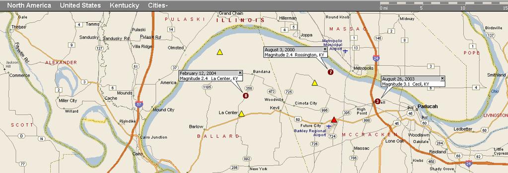
7 Temporary Seismic Network (PGDP area) 7 seismometers near PGDP, Wickliffe, Arlington, La Center, Lovelaceville, Ballard WMA, and Bardwell. Manually downloaded every 2-3 months and archived. Data compared to CERI and NEIC reported information.

8
 Magnitude Depth (km) Long. Lat.")
9 :21:42 06/20/05 Unprocessed :47:43 01/31/ :00:32 06/20/ :49:49 02/12/ :26:58 08/26/ :29:34 06/06/03 Depth (UK) Magnitude Depth (km) Long. Lat. Time (UTC) Date
10 Strong-motion Network Nine active stations. Two vertical arrays (VSAS, VSAP). Data recorded and stored locally temporarily. Events are recorded based on ground-motion thresholds specific to each site. Stored events are reviewed weekly via dial-up connection. Noise events are deleted. Seismic events are downloaded and archived. Usually average +/ event triggers/week. Boreholes available to expand vertical array network.
11 Central US Seismic Observatory Phase 1 complete: (CUSSO) Project Drilled, logged, and cased a 595 m hole near the central segment of the NMSZ A cooperative effort between federal agencies and various elements at the University of Kentucky: the United States Department of Energy the U.S. Geological Survey the Kentucky Geological Survey the Kentucky Research Consortium for Energy and Environment the Department of Earth and Environmental Sciences

12 Location Site Location (modified from USGS)

 into rock 4")

13 Borehole Specifics Mud-rotary operation 585 m (1,920 ) soil/sediment 9.5 m (30 ) into rock 4 steel casing (0 1,930 ) 4 stainless steel (1,930 1,950 )
14 Logging *log courtesy Drew Andrews and Steve Martin (KGS)

15 Site Amplification 1 st stiff layer, 260 m Existing vertical CUSSO site
16 Instrumentation Plan Free-field FBA-23 Existing 30 m Existing 260 m Section View Proposed 593 m
17 Immediate Tasks Instrumentation acquisition Perform refraction and reflection seismic imaging to obtain a comprehensive understanding of subsurface structural and stratigraphic geologic features in three dimensions in order to provide information regarding vertical and lateral variations in geometry and G max at the site. Measure deep borehole ground motion while shaking at the ground surface to obtain synthetic site response data.
18 Phase II: Instrumentation of the Deep Borehole Phase I of the Central United States Seismic Observatory (CUSSO) is completed Phase II will consist of installing and operating a three-dimensional array of borehole and surface accelerometers at the site A proposal has been submitted to NEHRP for funding of a workshop to be hosted at the University of Kentucky. The focus of the workshop will be to determine how to best instrument the observatory to compliment/enhance the existing instrumentation on site Phase II will begin upon completion of this workshop and after acquiring necessary funds to purchase the instrumentation
19 Project Significance Five significant technical contributions to earthquake engineering are ultimately expected from the final 3-D seismic observatory (CUSSO) in the New Madrid Seismic Zone: 1. Evaluation of the effect of deep soil conditions on earthquake ground motions. 2. Characterization of the dynamic soil properties of sediments in the New Madrid Seismic Zone. 3. Evaluation of current analytical models for deep soil sites. Several analytical models are currently being used to predict the seismic response of deep soil sites; however, these analytical procedures have not been validated for sites deeper than 100 m (i.e.,design engineers cannot be confident in their predictions). 4. Evaluation the recommended provisions of NEHRP, as they pertain to the New Madrid Seismic Zone. 5. Study of lateral propagation effects and spatial variation in ground motions. In addition to the scientific and engineering significance, the ability to reduce the large uncertainty in the existing seismic hazard definitions for western Kentucky will have positive societal impacts, particularly in the area of economic development.


20 Acknowledgements The Department of Energy The United States Geological Survey The Kentucky Research Consortium for Energy and Environment Mr. Austin Voorhees for providing the land for CUSSO Special acknowledgement: Dr. Ron Street. Who originally proposed the project in the early 1990 s during his tenure as Professor at the University of Kentucky Department of Geological Sciences
Seismic Velocity Measurements at Expanded Seismic Network Sites
 UK/KRCEE Doc #: P8.3 2005 Seismic Velocity Measurements at Expanded Seismic Network Sites Prepared by Kentucky Research Consortium for Energy and Environment 233 Mining and Minerals Building University
 Observed Seismicity (Earthquake Activity) in the Jackson Purchase Region of Western Kentucky: January through June 2003 Zhenming Wang Edward W. Woolery Baoping Shi Special Publication 6 Series XII, 2003
Seismic Recording Station AZ_PFO Summary Report
 Seismic Recording Station AZ_PFO Summary Report Thank you for hosting station AZ_PFO on your property. We hope that you find the enclosed report interesting. Your station is one of the 2000 USArray seismic
Seismic Recording Station TA_109C Summary Report
 Seismic Recording Station TA_109C Summary Report Thank you for hosting station TA_109C on your property. We hope that you find the enclosed report interesting. Your station is one of the 2000 USArray seismic
The San Andreas Fault Observatory at Depth: Recent Site Characterization Studies and the 2.2-Km-Deep Pilot Hole
 The San Andreas Fault Observatory at Depth: Recent Site Characterization Studies and the 2.2-Km-Deep Pilot Hole Steve Hickman and Bill Ellsworth (USGS) Mark Zoback (Stanford University) and the Pre-EarthScope
AN EVALUATION OF EARTHQUAKE GROUND-MOTION SITE EFFECTS AT TWO SITES UNDERLAIN BY DEEP SOILS IN WESTERN KENTUCKY
 University of Kentucky UKnowledge University of Kentucky Master's Theses Graduate School 2008 AN EVALUATION OF EARTHQUAKE GROUND-MOTION SITE EFFECTS AT TWO SITES UNDERLAIN BY DEEP SOILS IN WESTERN KENTUCKY
Originally published as:
 Originally published as: Henstock, T., McNeill, L., Dean, S., Barton, P., Tilmann, F., Rietbrock, A., Robinson, D., Gulick, S., Austin, J., Djajadihardja, Y., Natawidjaja, D., Permana, H., Bonneville,
ESTIMATION FOR S-WAVE VELOCITY PROFILE USING RAYLEIGH WAVE INDUCED BY THE STANDARD PENETRATION TEST
 4 th International Conference on Earthquake Geotechnical Engineering June 25-28, 2007 Paper No. 1395 ESTIMATION FOR S-WAVE VELOCITY PROFILE USING RAYLEIGH WAVE INDUCED BY THE STANDARD PENETRATION TEST
Earthquakes, Tsunamis and Nuclear Explosions: Open Data Exchange for Research and Monitoring in Seismology
 Earthquakes, Tsunamis and Nuclear Explosions: Open Data Exchange for Research and Monitoring in Seismology David Simpson IRIS Consortium Washington, DC Symposium on Data Sharing Plans for GEOSS and Benefits
GROUND MOTION CHARACTERISTIC IN THE KAOHSIUNG & PINGTUNG AREA, TAIWAN
 GROUND MOTION CHARACTERISTIC IN THE KAOHSIUNG & PINGTUNG AREA, TAIWAN Hsien-Jen Chiang 1, Kuo-Liang Wen 1, Tao-Ming Chang 2 1.Institute of Geophysics, National Central University,ROC 2.Department of Information
DEVELOPMENT OF EMPIRICAL CORRELATION BETWEEN SHEAR WAVE VELOCITY AND STANDARD PENETRATION RESISTANCE IN SOILS OF CHENNAI CITY
 DEVELOPMENT OF EMPIRICAL CORRELATION BETWEEN SHEAR WAVE VELOCITY AND STANDARD PENETRATION RESISTANCE IN SOILS OF CHENNAI CITY Uma Maheswari R 1, Boominathan A 2 and Dodagoudar G.R 3 1 Research Scholar,
The quarter-wavelength average velocity: a review of some past and recent application developments
 The quarter-wavelength average velocity: a review of some past and recent application developments V. Poggi, B. Edwards & D. Fäh Swiss Seismological Service, ETH Zürich, Switzerland SUMMARY: In recent
27th Seismic Research Review: Ground-Based Nuclear Explosion Monitoring Technologies
 EVALUATION OF CROSS-CORRELATION METHODS ON A MASSIVE SCALE FOR ACCURATE RELOCATION OF SEISMIC EVENTS Won-Young Kim, Paul G. Richards, David P. Schaff, Felix Waldhauser, and Jian Zhang Lamont-Doherty Earth
Western Kentucky CO 2 Storage Test
 Western Kentucky CO 2 Storage Test Principal Investigators: Rick Bowersox - Lexington Dave Williams - Henderson KGS First Friday Seminar Lexington, Kentucky March 4, 2011 The project proceeded in two phases:
the IRIS Consortium Collaborative, Multi-user Facilities for Research and Education Briefing NSF Business Systems Review September 9, 2008
 the IRIS Consortium Collaborative, Multi-user Facilities for Research and Education Briefing NSF Business Systems Review September 9, 2008 A facilities program for collection and distribution of seismological
Seismicity in Pennsylvania and the Pennsylvania State Seismic Network (PASEIS)
") Seismicity in Pennsylvania and the Pennsylvania State Seismic Network (PASEIS) Andy Nyblade Department of Geosciences, Penn State University May 19, 2017 Shale Network Workshop Introduction Review of historic
Seismicity in Pennsylvania and the Pennsylvania State Seismic Network (PASEIS) Andy Nyblade Department of Geosciences, Penn State University May 19, 2017 Shale Network Workshop Introduction Review of historic
Research infrastructures in FP7: Seismology and Geophysics
 Research infrastructures in FP7: Seismology and Geophysics Domenico Giardini, ETHZ Internation Workshop on Disaster Risk Reduction Bruxelles 29-30 October, 2009 EC FP7 2007-2013 Seven-year targeted program
Analysis Of Earthquake Records of Istanbul Earthquake Rapid Response System Stations Related to the Determination of Site Fundamental Frequency
 Analysis Of Earthquake Records of Istanbul Earthquake Rapid Response System Stations Related to the Determination of Site Fundamental Frequency A. C. Zulfikar, H. Alcik & E. Cakti Bogazici University,Kandilli
Induced Seismicity in the Groningen Field Further Studies Jan Dirk Jansen TU Delft
 KNGMG/PGK/SPE/KIVI Symposium The Science behind the Groningen Gas Field TU Delft, 1 February 2018 Induced Seismicity in the Groningen Field Further Studies Jan Dirk Jansen TU Delft 1 Background Jansen,
3D VISCO-ELASTIC WAVE PROPAGATION IN THE BORREGO VALLEY, CALIFORNIA
 3D VISCO-ELASTIC WAVE PROPAGATION IN THE BORREGO VALLEY, CALIFORNIA Kim B OLSEN 1, Robert L NIGBOR 2 And Takaaki KONNO 3 SUMMARY We have simulated 2-Hz wave propagation in a three-dimensional model of
INVESTIGATION OF SITE RESPONSE IN KATHMANDU VALLEY USING AFTERSHOCK DATA OF THE 2015 GORKHA EARTHQUAKE, NEPAL
 INVESTIGATION OF SITE RESPONSE IN KATHMANDU VALLEY USING AFTERSHOCK DATA OF THE 2015 GORKHA EARTHQUAKE, NEPAL Naresh MAHARJAN Supervisor: Toshiaki YOKOI MEE17704 Takumi HAYASHIDA ABSTRACT We used 16 aftershock
EMPIRICAL EVIDENCE FROM THE NORTHRIDGE EARTHQUAKE FOR SITE- SPECIFIC AMPLIFICATION FACTORS USED IN US BUILDING CODES
 EMPIRICAL EVIDENCE FROM THE NORTHRIDGE EARTHQUAKE FOR SITE- SPECIFIC AMPLIFICATION FACTORS USED IN US BUILDING CODES Roger D BORCHERDT And Thomas E FUMAL SUMMARY Site-specific amplification factors, F
P Wave Reflection and Refraction and SH Wave Refraction Data Processing in the Mooring, TN Area
 P Wave Reflection and Refraction and SH Wave Refraction Data Processing in the Mooring, TN Area Abstract: Author: Duayne Rieger Home Institution: Slippery Rock University of Pennsylvania REU Institution:
Haiti: Earthquake on January 12, 2010
 Geophysical Hazards and Plate Boundary Processes In Central America, Mexico and the Caribbean Haiti: Earthquake on January 12, 2010 Situation, achievements and perspective. Hotel La Condesa, Costa Rica
SEISMIC HAZARD ANALYSIS. Instructional Material Complementing FEMA 451, Design Examples Seismic Hazard Analysis 5a - 1
 SEISMIC HAZARD ANALYSIS Instructional Material Complementing FEMA 451, Design Examples Seismic Hazard Analysis 5a - 1 Seismic Hazard Analysis Deterministic procedures Probabilistic procedures USGS hazard
The UK GeoEnergy Test Bed Ceri J Vincent British Geological Survey
 The UK GeoEnergy Test Bed Ceri J Vincent British Geological Survey Thanks to Matthew Hall (GTB Theme Lead for G ERA), Phil Meldrum, Russell Swift, Oliver Kuras, Richard Luckett, Andrew Butcher, Jonathan
Seismic tests at Southern Ute Nation coal fire site
 Seismic tests at Southern Ute Nation coal fire site Sjoerd de Ridder and Seth S. Haines ABSTRACT We conducted a near surface seismic test at the Southern Ute Nation coal fire site near Durango, CO. The
Effects of Surface Geology on Seismic Motion
 4 th IASPEI / IAEE International Symposium: Effects of Surface Geology on Seismic Motion August 23 26, 2011 University of California Santa Barbara SITE EFFECTS MEASURED AT THE NEES@UCSB WILDLIFE STATION
Effects of Surface Geology on Seismic Motion
 4 th IASPEI / IAEE International Symposium: Effects of Surface Geology on Seismic Motion August 23 26, 2011 University of California Santa Barbara EFFECTS OF LOCAL GEOLOGY ON EARTHQUAKE GROUND MOTIONS:
THE NEW DIGITAL SEISMIC NETWORK IN GHANA THE WAYFORWARD AND THE CHALLENGES
 THE NEW DIGITAL SEISMIC NETWORK IN GHANA THE WAYFORWARD AND THE CHALLENGES By NICHOLAS OPOKU Seismologist, Ghana Geological Survey JANUARY, 2013 IRIS METADATA WORKSHOP - KUWAIT Seismicity / Instrumental
Initial Borehole Drilling and Testing in or Near Ignace
 JUNE 2016 PRELIMINARY ASSESSMENT OF POTENTIAL SUITABILITY Initial Borehole Drilling and Testing in or Near Ignace DRAFT FOR DISCUSSION WITH COMMUNITIES In 2010, the Nuclear Waste Management Organization
ACCOUNTING FOR SITE EFFECTS IN PROBABILISTIC SEISMIC HAZARD ANALYSIS: OVERVIEW OF THE SCEC PHASE III REPORT
 ACCOUNTING FOR SITE EFFECTS IN PROBABILISTIC SEISMIC HAZARD ANALYSIS: OVERVIEW OF THE SCEC PHASE III REPORT Edward H FIELD 1 And SCEC PHASE III WORKING GROUP 2 SUMMARY Probabilistic seismic hazard analysis
Japan Seismic Hazard Information Station
 Japan Seismic Hazard Information Station (J-SHIS) Hiroyuki Fujiwara National Research Institute for Earth Science and Disaster Prevention (NIED) Background of the Project Headquarters for Earthquake Research
[S06 ] Shear Wave Resonances in Sediments on the Deep Sea Floor
![[S06 ] Shear Wave Resonances in Sediments on the Deep Sea Floor](/thumbs/82/85496146.jpg "[S06 ] Shear Wave Resonances in Sediments on the Deep Sea Floor") page 1 of 16 [S06 ] Shear Wave Resonances in Sediments on the Deep Sea Floor I. Zeldenrust * and R. A. Stephen ** * Department of Geology Free University, Amsterdam ** Department of Geology and Geophysics
page 1 of 16 [S06 ] Shear Wave Resonances in Sediments on the Deep Sea Floor I. Zeldenrust * and R. A. Stephen ** * Department of Geology Free University, Amsterdam ** Department of Geology and Geophysics
NESEC NEWS. Published by the Northeast States Emergency Consortium. Wakefield, Massachusetts
 Published by the Northeast States Emergency Consortium Wakefield, Massachusetts Connecticut Maine Massachusetts New Hampshire New Jersey New York Rhode Island Vermont Volume 21 Issue 4 www.nesec.org Winter
By D.H. Lang 1 and J. Schwarz 1. This paper is an extract from
 Identification of the Subsoil Profile Characteristics at the Coyote Creek Outdoor Classroom (CCOC), San José, from Microtremor Measurements - A Contribution to the CCOC Blind Comparison Experiment By D.H.
CENTER FOR INFRASTRUCTURE ENGINEERING STUDIES
 1 CENTER FOR INFRASTRUCTURE ENGINEERING STUDIES Acquisition of an Engineering Seismograph By Dr. Neil Anderson UTC RE116 University Transportation Center Program at The University of Missouri-Rolla 2 Disclaimer
Refraction Microtremor for Shallow Shear Velocity in Urban Basins
 Refraction Microtremor for Shallow Shear Velocity in Urban Basins John Louie, Nevada Seismological Lab UNR students: J. B. Scott, T. Rasmussen, W. Thelen, M. Clark Collaborators: S. Pullammanappallil &
Comparison of CPT Based Liquefaction Potential and Shear Wave Velocity Maps by Using 3-Dimensional GIS
 Comparison of CPT Based Liquefaction Potential and Shear Wave Velocity Maps by Using 3-Dimensional GIS Muammer Tün, Uğur Avdan, Metin Altan, Can Ayday Anadolu University, Satellite and Space Sciences Research
Ground-Water Exploration in the Worthington Area of Nobles County: Summary of Seismic Data and Recent Test Drilling Results
 Ground-Water Exploration in the Worthington Area of Nobles County: Summary of Seismic Data and Recent Test Drilling Results Jim Berg and Todd Petersen Geophysicists, DNR Waters January 2000 Table of Contents
3D Elevation Program, Lidar in Missouri. West Central Regional Advanced LiDAR Workshop Ray Fox
 3D Elevation Program, Lidar in Missouri West Central Regional Advanced LiDAR Workshop Ray Fox National Enhanced Elevation Assessment (Dewberry, 2011) Sponsored by the National Digital Elevation Program
Unique Site Conditions and Response Analysis Challenges in the Central and Eastern U.S.
 Unique Site Conditions and Response Analysis Challenges in the Central and Eastern U.S. James R. Martin, C. Guney Olgun, & Morgan Eddy Civil and Environmental Engineering World Institute for Disaster Risk
Real time Monitoring System for Earthquakes and Tsunamis (DONET)
") Real time Monitoring System for Earthquakes and Tsunamis (DONET) NankaiTrough Yoshiyuki Kaneda Japan Agency for Marine-Earth Science and Technology (JAMSTEC) POGO@Seoul Presentation 1 Earthquakes in the
Real time Monitoring System for Earthquakes and Tsunamis (DONET) NankaiTrough Yoshiyuki Kaneda Japan Agency for Marine-Earth Science and Technology (JAMSTEC) POGO@Seoul Presentation 1 Earthquakes in the
Ship heave effects while drilling: observations from Legs 185 & 188
 Ship heave effects while drilling: observations from Legs 185 & 188 D. Goldberg 1, G. Myers 1, G. Guerin 1, D. Schroeder 2 and the Legs 185 & 188 scientific parties 1 Lamont-Doherty Earth Observatory,
Geological Mapping using Geophysics
 Geological Mapping using Geophysics Pugin, A.J.M. and T.H. Larson Illinois State Geological Survey, 615 E Peabody Dr., Champaign, IL 61820; E-mail: A.J.M. Pugin at pugin@isgs.uiuc.edu Mapping Techniques.
On May 4, 2001, central Arkansas experienced an M=4.4 earthquake followed by a
 1. Introduction On May 4, 2001, central Arkansas experienced an M=4.4 earthquake followed by a surprisingly large number of small earthquakes. We recorded about 2500 above the ambient noise level on a
Advantages of Regional and Global Data Exchange. Gavin Hayes U.S. Geological Survey, National Earthquake Information Center
 Advantages of Regional and Global Data Exchange Gavin Hayes U.S. Geological Survey, National Earthquake Information Center USGS NEIC Global Earthquake Response Area of responsibility => Global BUT - domestically,
Geophysical Site Investigation (Seismic methods) Amit Prashant Indian Institute of Technology Gandhinagar
 Amit Prashant Indian Institute of Technology Gandhinagar") Geophysical Site Investigation (Seismic methods) Amit Prashant Indian Institute of Technology Gandhinagar Short Course on Geotechnical Aspects of Earthquake Engineering 04 08 March, 2013 Seismic Waves
Geophysical Site Investigation (Seismic methods) Amit Prashant Indian Institute of Technology Gandhinagar Short Course on Geotechnical Aspects of Earthquake Engineering 04 08 March, 2013 Seismic Waves
Initial Borehole Drilling in the Hornepayne and Manitouwadge Area
 MAY 2017 PRELIMINARY ASSESSMENT OF POTENTIAL SUITABILITY Initial Borehole Drilling in the Hornepayne and Manitouwadge Area In 2010, the Nuclear Waste Management Organization (NWMO) began technical and
Harvey Thorleifson, Director, Minnesota Geological Survey. Status of geological mapping needed for groundwater protection in Minnesota
 Harvey Thorleifson, Director, Minnesota Geological Survey Status of geological mapping needed for groundwater protection in Minnesota Minnesota is located between the Dakotas and Wisconsin, north of Iowa,
Seismic Observation and Seismicity of Uganda
 (Uganda, Mr. Nyago Joseph, 2012-2013S) Seismic Observation and Seismicity of Uganda 1. Seismic observation in Uganda In 1989, UNESCO and the International Programs in Physical Sciences (IPPS) donated four
IAEA SAFETY STANDARDS Geotechnical Aspects of Site Evaluation and Foundations in NPPs, NS-G-3.6
 IAEA SAFETY STANDARDS Geotechnical Aspects of Site Evaluation and Foundations in NPPs, NS-G-3.6 Regional Workshop on Volcanic, Seismic, and Tsunami Hazard Assessment Related to NPP Siting Activities and
SEISMIC CALIBRATION OF THE EUROPEAN ARCTIC
 SEISMIC CALIBRATION OF THE EUROPEAN ARCTIC Svein Mykkeltveit, Frode Ringdal, Conrad Lindholm, NORSAR Elena Kremenetskaya, Kola Regional Seismological Centre Sponsored by U.S. Department of Energy Office
IGUT Seismic Network. Institute of Geophysics University of Tehran (IGUT) Mehdi Rezapour
 Mehdi Rezapour") IGUT Seismic Network Institute of Geophysics University of Tehran (IGUT) Mehdi Rezapour History of seismic monitoring in Iran The IGUT starts to record & Locate seismic events in the 1960 s using 5 WWSSN
IGUT Seismic Network Institute of Geophysics University of Tehran (IGUT) Mehdi Rezapour History of seismic monitoring in Iran The IGUT starts to record & Locate seismic events in the 1960 s using 5 WWSSN
27th Seismic Research Review: Ground-Based Nuclear Explosion Monitoring Technologies POSSIBLE EFFECTS OF FROZEN ROCK ON EXPLOSIVE COUPLING
 POSSIBLE EFFECTS OF FROZEN ROCK ON EXPLOSIVE COUPLING Mark Leidig 1, Jessie Bonner 1, Roger Hansen 2, Vladimir Romanovsky 2, Stephen Brown 3, Randy Martin 3, and Jim Lewkowicz 1 Weston Geophysical Corp.
Final Technical Report COLLECTION, COMPILATION AND ANALYSIS OF GEOLOGIC AND GEOTECHNICAL DATA FOR MAP PRODUCTION
 Final Technical Report COLLECTION, COMPILATION AND ANALYSIS OF GEOLOGIC AND GEOTECHNICAL DATA FOR MAP PRODUCTION External Grant Award Number 99-HQ-GR-0086 Robert A. Bauer, Coordinator CUSEC State Geologists,
Synthetic Near-Field Rock Motions in the New Madrid Seismic Zone
 Synthetic Near-Field Rock Motions in the New Madrid Seismic Zone Genda Chen*, Ph.D., P.E., and Mostafa El-Engebawy Engebawy,, Ph.D. *Associate Professor of Civil Engineering Department of Civil, Architecture
Verification of Predictions of Magnitude of Completeness Using an Earthquake Catalog
 Verification of Predictions of Magnitude of Completeness Using an Earthquake Catalog Designing induced seismic monitoring networks to meet regulations Dario Baturan Presented at GeoConvention 2015 Introduction
158 Reducing Earthquake Losses
 ndex A Accelerographs, 64 Active control systems, 83-84 Active mass damping, 83 Active tendons, 83 Advocates, role of, 116 Air Force Office of Scientific Research, 133 Alaska, 42-43 Alquist-Priolo Act,
Alaska Earthquake Center. By Natalia A. Ruppert Seismic Network Manager
 Alaska Earthquake Center By Natalia A. Ruppert Seismic Network Manager Geophysical Institute, University of Alaska Fairbanks Alaska Earthquake Center mission and historical perspective! Regional seismic
Initial Borehole Drilling and Testing in Central Huron,
 JULY 2016 PRELIMINARY ASSESSMENT OF POTENTIAL SUITABILITY Initial Borehole Drilling and Testing in Central Huron, Huron-Kinloss and South Bruce DRAFT FOR DISCUSSION WITH COMMUNITIES In 2012, at the request
Geotechnical Site Classification and Croatian National Annex for EC 8
 Geotechnical Site Classification and Croatian National Annex for EC 8 by Predrag Kvasnika University of Zagreb Faculty of Mining-Geology and Petroleum engineering Outline General Motivation Site classification
STRONG-MOTION SEISMOGRAPH NETWORK OPERATED BY NIED: K-NET AND KiK-net
 Journal of Japan Association for Earthquake Engineering, Vol. 4, No. 3 (Special Issue), 2004 STRONG-MOTION SEISMOGRAPH NETWORK OPERATED BY NIED: K-NET AND KiK-net Shin AOI 1, Takashi KUNUGI 2, and Hiroyuki
APPENDIX J. Dynamic Response Analysis
 APPENDIX J Dynamic Response Analysis August 25, 216 Appendix J Dynamic Response Analysis TABLE OF CONTENTS J1 INTRODUCTION... 1 J2 EARTHQUAKE TIME HISTORIES... 1 J3 MODEL AND INPUT DATA FOR SITE RESPONSE
CHAPTER 3 METHODOLOGY
 32 CHAPTER 3 METHODOLOGY 3.1 GENERAL In 1910, the seismological society of America identified the three groups of earthquake problems, the associated ground motions and the effect on structures. Indeed
Overview. Tools of the Trade. USGS Decision-Making Tools for Pre-Earthquake Mitigation and Post-Earthquake Response
 USGS Decision-Making Tools for Pre-Earthquake Mitigation and Post-Earthquake Response Tools of the Trade DAVID WALD United States Geological Survey NEHRP Workshop: Developing Earthquake Scenarios Sept
General Geologic Setting and Seismicity of the FHWA Project Site in the New Madrid Seismic Zone
 General Geologic Setting and Seismicity of the FHWA Project Site in the New Madrid Seismic Zone David Hoffman University of Missouri Rolla Natural Hazards Mitigation Institute Civil, Architectural & Environmental
Finding out what earthquakes have happened recently Subscribe to an alert system
 Finding out what earthquakes have happened recently Subscribe to an email alert system Hosted by the United States Geological Survey http://earthquake.usgs.gov/eqcenter/ens/ USGS USGS Once registered you
Downtown Anchorage Seismic Risk Assessment & Land Use Regulations to Mitigate Seismic Risk
 Prepared for: The Municipality of Anchorage Planning Department and the Geotechnical Advisory Commission Downtown Anchorage Seismic Risk Assessment & Land Use Regulations to Mitigate Seismic Risk Prepared
2.3 Notes: Earthquake Damage Can Be Reduced
 2.3 Notes: Earthquake Damage Can Be Reduced Earthquakes can cause severe damage and loss of life Each year, there is about one earthquake with a magnitude of or higher-this is an extremely earthquake.
Borehole Array observation system operated by Tono Research Institute of Earthquake Science and Some Interesting Result
 Borehole Array observation system operated by Tono Research Institute of Earthquake Science and Some Interesting Result Yasuhiro ASAI Tono Research Institute of Earthquake Science (TRIES) Association for
Report on the evaluation of geophysical data and seismic site effects in the Maltese archipelago in relation to the calculation of seismic risk
 Project Acronym: SIMIT Project Name: Sistema Integrato di Protezione CivileTransfrontalieroItalo-Maltese Project Code: B1-2.19/11 Start Date: March 2013 End Date: September 2015 Work Package 2: Identification
A METHODOLOGY FOR ASSESSING EARTHQUAKE-INDUCED LANDSLIDE RISK. Agency for the Environmental Protection, ITALY (
 A METHODOLOGY FOR ASSESSING EARTHQUAKE-INDUCED LANDSLIDE RISK Roberto W. Romeo 1, Randall W. Jibson 2 & Antonio Pugliese 3 1 University of Urbino, ITALY (e-mail: rwromeo@uniurb.it) 2 U.S. Geological Survey
New Madrid and Central U.S. Region Earthquake Hazard
 New Madrid and Central U.S. Region Earthquake Hazard Rob Williams U.S. Geological Survey, Golden, CO March 16, 2017 Reelfoot Lake, TN U.S. Department of the Interior U.S. Geological Survey 1811-12 New
Metallic Mineral Exploration in Minnesota: Typical Exploration Activities. Division of Lands and Minerals Minnesota Department of Natural Resources
 Metallic Mineral Exploration in Minnesota: Typical Exploration Activities Division of Lands and Minerals Minnesota Department of Natural Resources Metallic minerals can only be mined economically where
Japan Agency for Marine-Earth Science and Technology (JAMSTEC), 2-15 Natsushima-cho, Yokosuka, Kanagawa, , JAPAN
, 2-15 Natsushima-cho, Yokosuka, Kanagawa, , JAPAN") LARGE EARTHQUAKE AND ASSOCIATED PHENOMENA OBSERVED WITH SEAFLOOR CABLED OBSERVATORY NEAR EPICENTER - AN IMPLICATION FOR POSSIBLE ADDITIONAL MEASUREMENT WITH TELECOMMUNICATION NETWORKS FOR IDENTIFICATION
LARGE EARTHQUAKE AND ASSOCIATED PHENOMENA OBSERVED WITH SEAFLOOR CABLED OBSERVATORY NEAR EPICENTER - AN IMPLICATION FOR POSSIBLE ADDITIONAL MEASUREMENT WITH TELECOMMUNICATION NETWORKS FOR IDENTIFICATION
Seismic Velocity Database for the New Madrid Seismic Zone and Its Vicinity. Qian Li Kentucky Geological Survey, University of Kentucky
 Kentucky Geological Survey James C. Cobb, State Geologist and Director University of Kentucky, Lexington Seismic Velocity Database for the New Madrid Seismic Zone and Its Vicinity Qian Li Kentucky Geological
BAD VIBRATIONS (Earthquakes/Tsunamis)
") Society of Exploration Geophysicists Youth Education Committee BAD VIBRATIONS (Earthquakes/Tsunamis) ACTIVITY RESOURCES Primary and Secondary (4th 12th) Includes web links on using a laptop as an oscilloscope
Society of Exploration Geophysicists Youth Education Committee BAD VIBRATIONS (Earthquakes/Tsunamis) ACTIVITY RESOURCES Primary and Secondary (4th 12th) Includes web links on using a laptop as an oscilloscope
COOPERATIVE RESEARCH IN EARTHQUAKE ENGINEERING AND HAZARDS MITIGATION: THE CENTRAL UNITED STATES AND NORTHWESTERN CHINA
 COOPERATIVE RESEARCH IN EARTHQUAKE ENGINEERING AND HAZARDS MITIGATION: THE CENTRAL UNITED STATES AND NORTHWESTERN CHINA Z. Wang 1, E.W. Woolery 2, and L. Wang 3 1 Head, Geologic Hazards Section, Kentucky
REAL-TIME ASSESSMENT OF EARTHQUAKE DISASTER IN YOKOHAMA BASED ON DENSE STRONG-MOTION NETWORK
 REAL-TIME ASSESSMENT OF EARTHQUAKE DISASTER IN YOKOHAMA BASED ON DENSE STRONG-MOTION NETWORK Saburoh MIDORIKAWA 1 And Susumu ABE 2 SUMMARY This paper describes a system for REal-time Assessment of earthquake
A THEORETICAL MODEL FOR SITE COEFFICIENTS IN BUILDING CODE PROVISIONS
 13 th World Conference on Earthquake Engineering Vancouver, B.C., Canada August 1-6, 2004 Paper No. 3029 A THEORETICAL MODEL FOR SITE COEFFICIENTS IN BUILDING CODE PROVISIONS Roger D. Borcherdt 1 SUMMARY
Arthur Frankel, William Stephenson, David Carver, Jack Odum, Robert Williams, and Susan Rhea U.S. Geological Survey
 Probabilistic Seismic Hazard Maps for Seattle: 3D Sedimentary Basin Effects, Nonlinear Site Response, and Uncertainties from Random Velocity Variations Arthur Frankel, William Stephenson, David Carver,
Lima Project: Seismic Refraction and Resistivity Survey. Alten du Plessis Global Geophysical
 Lima Project: Seismic Refraction and Resistivity Survey Alten du Plessis Global Geophysical Report no 0706/2006 18 December 2006 Lima Project: Seismic Refraction and Resistivity Survey by Alten du Plessis
Geology 229 Engineering Geology Lecture 27. Earthquake Engineering (Reference West, Ch. 18)
") Geology 229 Engineering Geology Lecture 27 Earthquake Engineering (Reference West, Ch. 18) Earthquake Engineering 1. General introduction of earthquakes 2. Seismic Hazards 3. Strong ground motion Exactly
Geology 229 Engineering Geology Lecture 27 Earthquake Engineering (Reference West, Ch. 18) Earthquake Engineering 1. General introduction of earthquakes 2. Seismic Hazards 3. Strong ground motion Exactly
7.1 FIJI 1, :57:22 UTC
 A magnitude 7.1 earthquake struck 141 km (88 miles) northeast of Ndoi Island, Fiji, and 313 km (194 mi) west-northwest of Nuku alofa, Tonga according to the US Geological Survey, but there were no reports
GEOMATICS AND DISASTER MANAGEMENT: Early Impact assessment in Haiti
 GEOMATICS AND DISASTER MANAGEMENT: Early Impact assessment in Haiti We will talk about... Post-disaster response: the main questions to be answered Post-disaster rapid mapping: the role of Geomatics The
Results of the Lacq pilot s monitoring Focus on microseismicity. Joëlle HY-BILLIOT 10 may - Venice
 DGEP/SCR/RD Results of the Lacq pilot s monitoring Focus on microseismicity Joëlle HY-BILLIOT 10 may - Venice CCS pilot, Lacq, France Introduction Key areas Presentation of the Lacq pilot Monitoring program
Agency Vision and Decision- Maker Needs: A USGS Perspective
 Agency Vision and Decision- Maker Needs: A USGS Perspective Connecting Grassroots to Government for Disaster Management David Applegate USGS Associate Director for Natural Hazards September 13, 2012 U.S.
High Resolution Seismic for Minerals
 High Resolution Seismic for Minerals Greg Turner HiSeis Pty Ltd MEGWA April 2013 WELCOME HiSeis Pty Ltd, Suite 4 Enterprise Unit 3, 9 DeLaeter Way, Bentley, WA 6102 Ph: +61 8 9470 9866 www.hiseis.com Used
Integration of Probabilistic Seismic Hazard Analysis with Nonlinear Site Effects and Application to the Mississippi Embayment
 Integration of Probabilistic Seismic Hazard Analysis with Nonlinear Site Effects and Application to the Mississippi Embayment Duhee Park and Youssef M.A. Hashash ABSTRACT An integrated probabilistic seismic
SONGS Seismic Research Projects
 SONGS Seismic Research Projects Energy Division Independent Peer Review Group September 21, 2012 Agenda Background Overview Project Support Permits, Approvals, and Reviews Schedule Use of Advanced Technologies
Estimating energy balance for hydraulic fracture stimulations: Lessons Learned from Basel
 Estimating energy balance for hydraulic fracture stimulations: Lessons Learned from Basel David W. Eaton*, Department of Geoscience, University of Calgary, Calgary, Canada eatond@ucalgary.ca and Neda Boroumand,
Absolute strain determination from a calibrated seismic field experiment
 Absolute strain determination Absolute strain determination from a calibrated seismic field experiment David W. Eaton, Adam Pidlisecky, Robert J. Ferguson and Kevin W. Hall ABSTRACT The concepts of displacement
Author: Seth Stein, William Deering Professor of Earth & Planetary Sciences, Northwestern University. Background for Calais & Stein paper
 Background for Calais & Stein paper The GPS data reported here are important for understanding earthquakes in the central U.S. Large (magnitude 7) earthquakes on the New Madrid Fault system shook the Midwest
A STUDY ON THE BLASTING VIBRATION CONTROL OF CREEP MASS HIGH SLOPE
 A STUDY ON THE BLASTING VIBRATION CONTROL OF CREEP MASS HIGH SLOPE CEN Li, JIANG Cang-ru School of Civil Engineering & Architecture, Wuhan University of Technology, Wuhan 430070, P.R.China Email: myfqp@tom.com
Global Instrumental Seismicity Catalogue
 Caribbean Regional Programme Workshop Port of Spain, Trinidad & Tobago, May 2 nd 2011 Global Instrumental Seismicity Catalogue Marco Pagani Executive Committee Hazard Coordinator, GEM Foundation Slides
Development of U. S. National Seismic Hazard Maps and Implementation in the International Building Code
 Development of U. S. National Seismic Hazard Maps and Implementation in the International Building Code Mark D. Petersen (U.S. Geological Survey) http://earthquake.usgs.gov/hazmaps/ Seismic hazard analysis
TexNet and CISR Integrated Seismicity Monitoring and Research in Texas
 Alliance Regulatory and Legislative Forum August, 2015 TexNet and CISR Integrated Seismicity Monitoring and Research in Texas Scott W. Tinker Bureau of Economic Geology University of Texas at Austin Energy
Tsunami Response and the Enhance PTWC Alerts
 Tsunami Response and the Enhance PTWC Alerts Ken Gledhill GeoNet Project Director Chair, Intergovernmental Coordination Group, Pacific Tsunami Warning and Mitigation System (PTWS) Overview 1. Procedures
I. Locations of Earthquakes. Announcements. Earthquakes Ch. 5. video Northridge, California earthquake, lecture on Chapter 5 Earthquakes!
 51-100-21 Environmental Geology Summer 2006 Tuesday & Thursday 6-9:20 p.m. Dr. Beyer Earthquakes Ch. 5 I. Locations of Earthquakes II. Earthquake Processes III. Effects of Earthquakes IV. Earthquake Risk