THE NEW DIGITAL SEISMIC NETWORK IN GHANA THE WAYFORWARD AND THE CHALLENGES
|
|
|
- Elizabeth Burke
- 5 years ago
- Views:
Transcription


1 THE NEW DIGITAL SEISMIC NETWORK IN GHANA THE WAYFORWARD AND THE CHALLENGES By NICHOLAS OPOKU Seismologist, Ghana Geological Survey JANUARY, 2013 IRIS METADATA WORKSHOP - KUWAIT

2 Seismicity / Instrumental Recording of Earthquakes in Ghana Ø The first Documented Earthquake in Ghana Occurred in the year 1636 Ø Magnitudes of significant events 4 to 6.5 Ø A Milne s single-boom seismograph was the first Seismic Instrument installed in the year Ø Geotech Long Period Z component Seismograph was installed in March, 1973 Ø An Analog seismic network which were all S-13 short period seismometers were procured from Teledyne Geotech (U.S.A) and the installation was completed in June 1987.


3 System Components of the Real Time Analog Seismic Network S-13 Short Period Seismometer in a Vault at Shai Hills. Booster Station at Amanokrom Central Recording Staion at GGS HeadQuarters, Accra Analog seismic Network
4 The New Digital Seismic Network The Government of Ghana in 2010 gave budgetary support to GGS to fund the purchase and installation of six remote stations digital broadband seismic network to replace the defunct analogue seismic network. The package also included ten stand alone strong motion accelerometers and the building of a new Seismological Observatory. The Digital Seismic Network equipment were procured from Nanometrics Inc., Canada. The network consist of six remote sites digital broad band stations transmitting real time seismic data to the central Observatory Accra.


5 System Components and Setup Carina105 Transceiver GGS LAN Cygnus205 Transceiver Cygnus205 Transceiver Ethernet Data Acquisition Servers Trident305 Digitizer Trident305 Digitizer GGS Workstations Event Detection & Processing, Network & Data Management, Data & SOH Monitoring, etc. Trillium Compact 3 x Trillium Compact Stations (Transmitted over V-Sat Telemetry Trillium 120 PA 3 x Trillium 120PA Stations (Transmitted over V-Sat Telemetry) GGS Acquisition Hub


 at")
6 Remote And Central Recording Stations Facilities Map of stations lcation Remote Station Seismological Observatory Satellite Receiver (bigger) at Seismological Observatory

7 CRF for Data Acqusition, Event Processing, Publication, Notification & Storage Athena Server Apollo Server Hydra Blue Server Carina Hydra Red Server UPS v All data from the Remote Sites are Received by the 3.8meter Satellite antenna on to the Carina v The Carina streams the data onto the Apollo Server. v The Apollo server temporary stores and displays the waveform. v The Hydra Server detects and processed any events in real time automatically. It then post the event and processing history to v Athena Web page for display, permanent storage and notification.

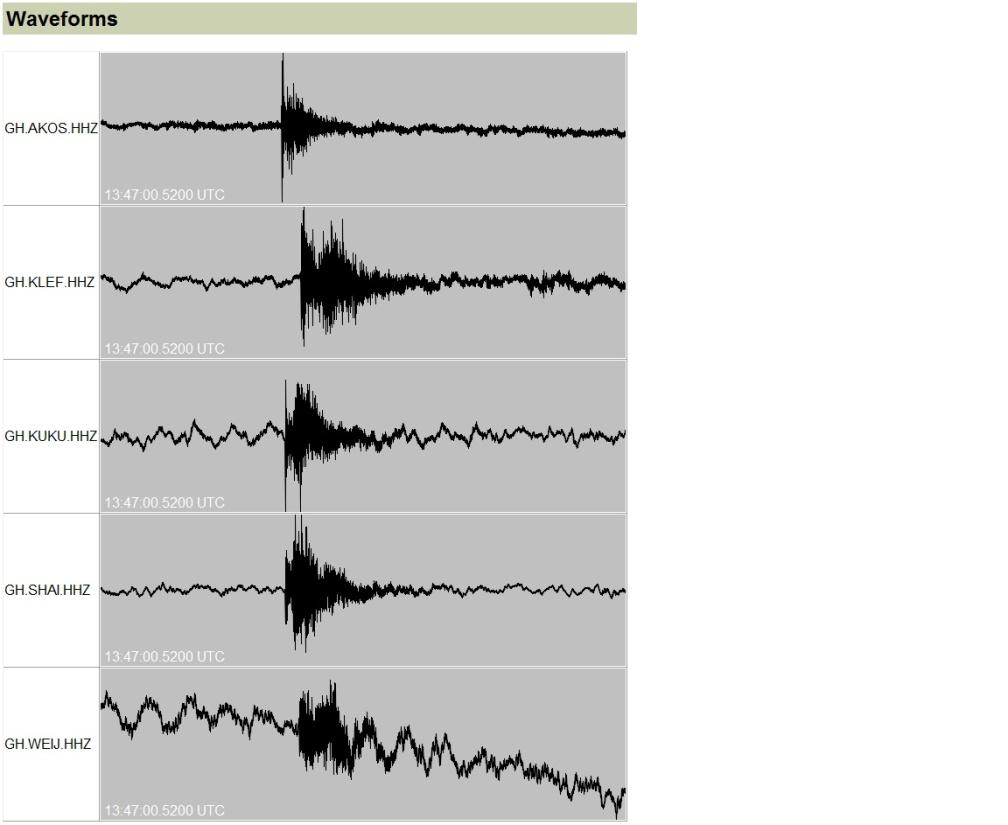
8 Apollo Waveform

9 Apollo Project on Client Workstation Computer Retrieves and Archives Waveform Data

10 Hydra Software Main Page

11 Event Post Processing by Hydra

12 Athena Web Page Displaying Processed Events by Hydra

13 Atlas Local Event Post Processing Software Locally recorded event by Ghana Digital Seismic Network. Automatically Processed by Hydra. Waveform extracted using atlas for Post Processing

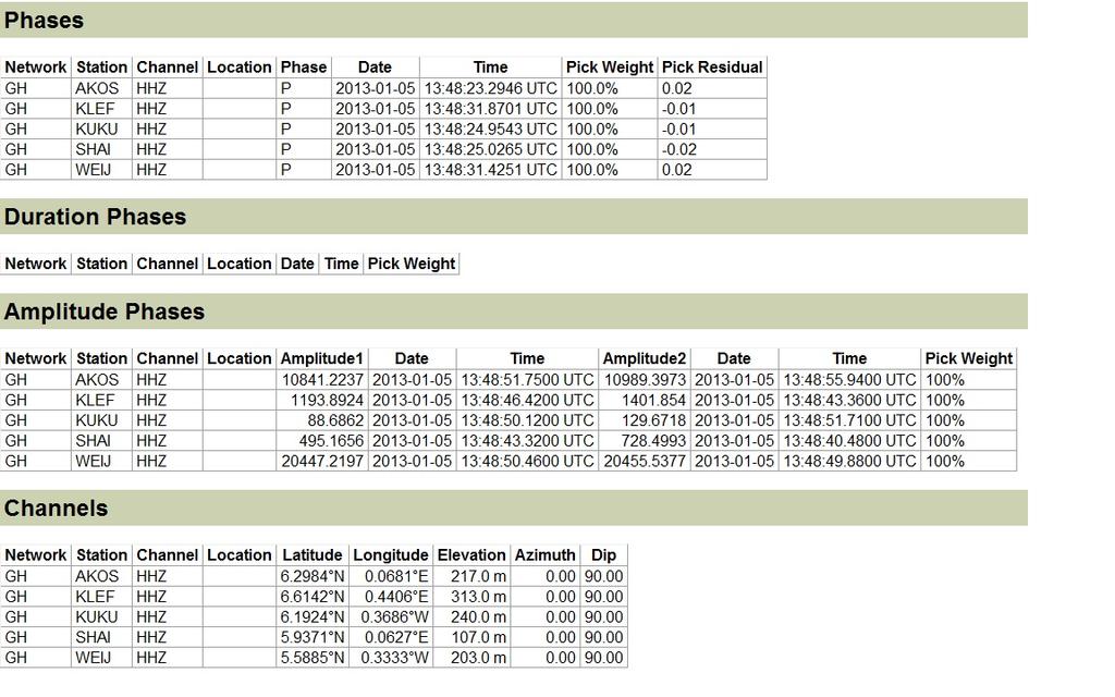
14 Atlas Event Bulleting


15 Epicentral location of local events in Ghana and beyond Micro-Seismic events Recorded in Ghana Seismic events Recorded within W/A Sub - Region
 and water supply and sewage treatment facilities (Weija dam).")
16 10 x Strong Motion Stations (Data recorded to local CF media) Taurus Digitizer The Strong Motion Equipments Ten standalone strong motion accelerometers installed on critical or lifeline structures such as electrical power facilities (Akosombo and Akuse dams) and water supply and sewage treatment facilities (Weija dam). Titan Accelerometer Buffered operations mode assures minimal power consumption. The Purpose of this strong motion accelerometers is to determine: The nature of earthquake ground motion and its impact on structures The duration of the shaken The frequencies of the motion Requires scheduled station visits to swap media before reaching full recording capacity

17 Expected Aims and Objectives to be Achieved The recorded data from the entire set up will help Ghana obtain Ground Motion Estimates to generate a new national seismic hazard map. This will then form the basis for: Ø Effective Land Use Planning Ø A new Building Code Provision Ø Seismic Design Criteria Critical or Lifeline Structures And For Research into the internal composition of the earth.


18 Way Forward v Extend the seismic network to cover other places to have a good coverage area in Ghana. v Co-operation, sharing of data and extension of the network within the entire West African Subregion. v Efforts are underway to integrate our system into the Global Seismic Network for the sharing of information. v Sustenance of capacity building of Seismologists, Earthquake Engineers, Technicians and other supporting staff to keep them abreast with time.
 to avoid data lost over a long period.")
19 Challenges Funding for the mentainance of the Seismic Network including the main Central Observatory. Funding of activities to be carried out in the West African Sub - Region. Rapid access to spare parts for replacement when there is a break down (especialy batteries and solar panels) to avoid data lost over a long period. Training of Seismologists and other Technical Staff.
Seismicity in Pennsylvania and the Pennsylvania State Seismic Network (PASEIS)
") Seismicity in Pennsylvania and the Pennsylvania State Seismic Network (PASEIS) Andy Nyblade Department of Geosciences, Penn State University May 19, 2017 Shale Network Workshop Introduction Review of historic
Seismicity in Pennsylvania and the Pennsylvania State Seismic Network (PASEIS) Andy Nyblade Department of Geosciences, Penn State University May 19, 2017 Shale Network Workshop Introduction Review of historic
Seismic Observation and Seismicity of Uganda
 (Uganda, Mr. Nyago Joseph, 2012-2013S) Seismic Observation and Seismicity of Uganda 1. Seismic observation in Uganda In 1989, UNESCO and the International Programs in Physical Sciences (IPPS) donated four
Seismic Recording Station AZ_PFO Summary Report
 Seismic Recording Station AZ_PFO Summary Report Thank you for hosting station AZ_PFO on your property. We hope that you find the enclosed report interesting. Your station is one of the 2000 USArray seismic
Seismic Recording Station TA_109C Summary Report
 Seismic Recording Station TA_109C Summary Report Thank you for hosting station TA_109C on your property. We hope that you find the enclosed report interesting. Your station is one of the 2000 USArray seismic
SCEK Report on Phase I ( ) Induced Seismicity Monitoring Project (ISMP) Carlos Salas, VP Oil & Gas, Geoscience BC
 Induced Seismicity Monitoring Project (ISMP) Carlos Salas, VP Oil & Gas, Geoscience BC") SCEK Report on Phase I (2012 2013) Induced Seismicity Monitoring Project (ISMP) Carlos Salas, VP Oil & Gas, Geoscience BC Contents Background... 2 Summary of Activities... 5 Additional Work... 8 References...
SCEK Report on Phase I (2012 2013) Induced Seismicity Monitoring Project (ISMP) Carlos Salas, VP Oil & Gas, Geoscience BC Contents Background... 2 Summary of Activities... 5 Additional Work... 8 References...
IGUT Seismic Network. Institute of Geophysics University of Tehran (IGUT) Mehdi Rezapour
 Mehdi Rezapour") IGUT Seismic Network Institute of Geophysics University of Tehran (IGUT) Mehdi Rezapour History of seismic monitoring in Iran The IGUT starts to record & Locate seismic events in the 1960 s using 5 WWSSN
IGUT Seismic Network Institute of Geophysics University of Tehran (IGUT) Mehdi Rezapour History of seismic monitoring in Iran The IGUT starts to record & Locate seismic events in the 1960 s using 5 WWSSN
the IRIS Consortium Collaborative, Multi-user Facilities for Research and Education Briefing NSF Business Systems Review September 9, 2008
 the IRIS Consortium Collaborative, Multi-user Facilities for Research and Education Briefing NSF Business Systems Review September 9, 2008 A facilities program for collection and distribution of seismological
NATIONAL SEISMIC NETWORKS OF TURKEY
 Ministry of Public Works and Settlement General Directorate of Disaster Affairs EARTHQUAKE RESEARCH DEPARMENT (GDDA- ERD) NATIONAL SEISMIC NETWORKS OF TURKEY RELEMR WORKSHOP İSTANBUL - 2008 Sami ZÜNBÜL
Patricia Mavazhe and. Marimira Kwangwari METEOROLOGICAL SERVICES DEPARTMENT
 MANAGING WAVEFORM DATA AND METADATA FOR SEISMIC NETWORKS; 14-18 January 2013, Kuwait City, Kuwait SEISMIC OBSERVATION NETWORK IN ZIMBABWE Patricia Mavazhe and Marimira Kwangwari METEOROLOGICAL SERVICES
Earthquakes, Tsunamis and Nuclear Explosions: Open Data Exchange for Research and Monitoring in Seismology
 Earthquakes, Tsunamis and Nuclear Explosions: Open Data Exchange for Research and Monitoring in Seismology David Simpson IRIS Consortium Washington, DC Symposium on Data Sharing Plans for GEOSS and Benefits
National Earthquake Monitoring for Tsunami Early Warning. Burin Wechbunthung Sumalee Prachaub Seismological Bureau, Thai Meteorological Department
 National Earthquake Monitoring for Tsunami Early Warning Burin Wechbunthung Sumalee Prachaub Seismological Bureau, Thai Meteorological Department Seismic Sources Out line Historical Earthquake Damage from
Seismic Observation and Seismicity of Zimbabwe
 Seismic Observation and Seismicity of Zimbabwe Mr. Innocent Gibbon Tirivanhu MASUKWEDZA (2016 Global Seismology course) Meteorological Services Department of Zimbabwe 1. Introduction The Seismology section
Seismic and Tsunami Observations of Indonesia
 (Indonesia, Mr. Fatchurochman Iman, 2010-2011S, Mr. Dwi Hartanto/Mr. Tatok Yatimantoro, 2011-2012T) Seismic and Tsunami Observations of Indonesia 1. Seismic Monitoring Agency for Meteorology, Climatology
Objective. Background
 Proposal Closing the Seismic Monitoring Gap at Mount Shasta Volcano Shasta-Trinity National Forest, California USGS California Volcano Observatory February 2017 Objective Install three new seismograph
LOG_aLevel. Tsunami Warning System
 LOG_aLevel Tsunami Warning System General Acoustics e.k. Am Kiel-Kanal 1 24106 Kiel Germany Phone: +49 431 5 80 81 80 www.generalacoustics.com Info@generalacoustics.com LOG_aLevel Tsunami Warning System
Notes on Comparing the Nano-Resolution Depth Sensor to the Co-located Ocean Bottom Seismometer at MARS
 Notes on Comparing the Nano-Resolution Depth Sensor to the Co-located Ocean Bottom Seismometer at MARS Elena Tolkova, Theo Schaad 1 1 Paroscientific, Inc., and Quartz Seismic Sensors, Inc. October 15,
arxiv: v1 [physics.geo-ph] 31 Dec 2013
![arxiv: v1 [physics.geo-ph] 31 Dec 2013](/thumbs/95/125064092.jpg "arxiv: v1 [physics.geo-ph] 31 Dec 2013") Comparing the Nano-Resolution Depth Sensor to the Co-located Ocean Bottom Seismometer at MARS Elena Tolkova 1, Theo Schaad 2 1 NorthWest Research Associates 2 Paroscientific, Inc., and Quartz Seismic Sensors,
Comparing the Nano-Resolution Depth Sensor to the Co-located Ocean Bottom Seismometer at MARS Elena Tolkova 1, Theo Schaad 2 1 NorthWest Research Associates 2 Paroscientific, Inc., and Quartz Seismic Sensors,
Seismic Monitoring for Geothermal plants
 Seismic Monitoring for Geothermal plants Seismic Monitoring Geothermal plants Why seismic monitoring: Seismic events, whether they are caused by local tectonics, fracturing of the overburden or induced
Absolute strain determination from a calibrated seismic field experiment
 Absolute strain determination Absolute strain determination from a calibrated seismic field experiment David W. Eaton, Adam Pidlisecky, Robert J. Ferguson and Kevin W. Hall ABSTRACT The concepts of displacement
The 2003, M W 7.2 Fiordland Earthquake, and its nearsource aftershock strong motion data
 The 2003, M W 7.2 Fiordland Earthquake, and its nearsource aftershock strong motion data P. McGinty Institute of Geological & Nuclear Sciences, PO Box 30-368, Lower Hutt, New Zealand 2004 NZSEE Conference
Wireless Networks in Geophysical Monitoring
 Workshop on New Frontiers in Internet of Things 7-18 March 2016 Trieste, Italy Wireless Networks in Geophysical Monitoring Hairo Villalobos Vulcanological and Seismological Observatory of Costa Rica, National
Egyptian National Seismological Network (ENSN) and its Roles for Monitoring the Seismic Activity
 and its Roles for Monitoring the Seismic Activity") Egyptian National Seismological Network (ENSN) and its Roles for Monitoring the Seismic Activity Seismologist at National Research Institute of Astronomy and Geophysics (NRIAG), Egypt Outlines: ENSN Overview
Egyptian National Seismological Network (ENSN) and its Roles for Monitoring the Seismic Activity Seismologist at National Research Institute of Astronomy and Geophysics (NRIAG), Egypt Outlines: ENSN Overview
Seismicity in Pennsylvania and the Pennsylvania State Seismic Network (PASEIS)
") Seismicity in Pennsylvania and the Pennsylvania State Seismic Network (PASEIS) Andy Nyblade and Kyle Homman Department of Geosciences, Penn State University April 4, 2017 PresentaIon made to the Geophysical
Seismicity in Pennsylvania and the Pennsylvania State Seismic Network (PASEIS) Andy Nyblade and Kyle Homman Department of Geosciences, Penn State University April 4, 2017 PresentaIon made to the Geophysical
Kentucky Seismic and Strong Motion Network - Including the Central United States Seismic Observatory (CUSSO)
") Kentucky Seismic and Strong Motion Network - Including the Central United States Seismic Observatory (CUSSO) Jonathan McIntyre Kentucky Geological Survey University of Kentucky Zhenming Wang Kentucky Geological
Kentucky Seismic and Strong Motion Network - Including the Central United States Seismic Observatory (CUSSO) Jonathan McIntyre Kentucky Geological Survey University of Kentucky Zhenming Wang Kentucky Geological
The EarthScope Geophysical Observatories. Slides courtesy Bob Woodward, Incorporated Research Institutions for Seismology (IRIS)
") The EarthScope Geophysical Observatories Slides courtesy Bob Woodward, Incorporated Research Institutions for Seismology (IRIS) 1 EarthScope Project Study the four dimensional structure and evolution of
The EarthScope Geophysical Observatories Slides courtesy Bob Woodward, Incorporated Research Institutions for Seismology (IRIS) 1 EarthScope Project Study the four dimensional structure and evolution of
1 Introduction. Station Type No. Synoptic/GTS 17 Principal 172 Ordinary 546 Precipitation
 Use of Automatic Weather Stations in Ethiopia Dula Shanko National Meteorological Agency(NMA), Addis Ababa, Ethiopia Phone: +251116639662, Mob +251911208024 Fax +251116625292, Email: Du_shanko@yahoo.com
Key Stage 4 - Volcano Eruption! Task sheet: phase 1
 Task sheet: phase 1 Rotimon is an imaginary island. La Soufriere is its youngest volcano. It last erupted in the 1970s. It is not monitored at the moment. Recently the volcano has shown some strange signs.
Progress Report No Norwegian National Seismic Network
 Progress Report No. 1-2005 for Norwegian National Seismic Network January 1 st to June 30 th, 2005. Supported by University of Bergen, Faculty of Mathematics and Natural Sciences and Norwegian Oil Industry
Alaska Earthquake Center. By Natalia A. Ruppert Seismic Network Manager
 Alaska Earthquake Center By Natalia A. Ruppert Seismic Network Manager Geophysical Institute, University of Alaska Fairbanks Alaska Earthquake Center mission and historical perspective! Regional seismic
Geological Survey of Canada: Canadian National Seismic Network
 Operational Procedures of Agencies Contributing to the ISC Geological Survey of Canada: Canadian National Seismic Network Taimi Mulder Canadian Hazards Information Service Geological Survey of Canada Sidney,
External Grant Award Number 01HQAG0009 WESTERN GREAT BASIN SEISMIC NETWORK OPERATIONS. December 1, 2000 to November 30, 2001
 External Grant Award Number 01HQAG0009 WESTERN GREAT BASIN SEISMIC NETWORK OPERATIONS December 1, 2000 to November 30, 2001 Glenn P. Biasi University of Nevada Reno Seismological Laboratory MS-174 Reno,
Flash flood forecasting and warning infrastructures of National Meteorology and Hydrological Services of Cambodia
 Development and Implementation of the South East Asia Flash Flood Guidance System (SEAFFGS) Ha Noi, Viet Nam, 20-23 November 2017 Flash flood forecasting and warning infrastructures of National Meteorology
GEOGRAPHIC INFORMATION SYSTEM (GES203)
") GEOGRAPHIC INFORMATION SYSTEM (GES203) GIS Components Level 2:1 By: Mrs Mupfiga Presentation Layout Recap Learning Objectives Components of GIS GIS Data References Lecture Evaluation Learning Objectives
GEOGRAPHIC INFORMATION SYSTEM (GES203) GIS Components Level 2:1 By: Mrs Mupfiga Presentation Layout Recap Learning Objectives Components of GIS GIS Data References Lecture Evaluation Learning Objectives
General Information: Real-time onsite solar forecasting
 General Information: Real-time onsite solar forecasting Introduction The Fulcrum3D CloudCAM system is a robust, turn-key cloud detection and solar forecasting system, targeted at optimal management of
Geospatial application in Kiribati
 Geospatial application in Kiribati ICC-21 ST RESAP (9 TH TO 13 TH OCTOBER, 2017) BANGKOK, THAILAND Outline Kiribati Profile Natural disasters in Kiribati Achievements Challenges/Issues Ways forward 1 Kiribati
Earthquake,Tsunami,Volcano Monitoring & Warning System in Korea. Jimin Lee Earthquake & Volcano Monitoring Division KMA
 Earthquake,Tsunami,Volcano Monitoring & Warning System in Korea Jimin Lee Earthquake & Volcano Monitoring Division KMA 1 2 Brief History & Vision of KMA Introduction of Services 3 Korea National Seismographic
STS41-D Solar Array Flight Experiment
 The Space Congress Proceedings 1984 (21st) New Opportunities In Space Apr 1st, 8:00 AM STS41-D Solar Array Flight Experiment Gary F. Turner Manager, Solar Array Programs Lockheed Missiles & Space Co.,
Nanometrics Posthole Seismometers. World Class Performance
 Contents Summary... 3 Performance of the Trillium Posthole versus World Class Vault Instruments... 3 Variation in Noise with Depth... 3 Installation Examples... 4 Shallow Bedrock Installation... 4 Thick
TexNet and CISR: An Update on Monitoring and Understanding Seismicity in Texas
 TexNet and CISR: An Update on Monitoring and Understanding Seismicity in Texas Michael H. Young a, Alexandros Savvaidis a, Peter Hennings a, Ellen Rathje b a Bureau of Economic Geology, Jackson School
Earthquakes in Canada
 Earthquakes in Canada Maurice Lamontagne, Ph.D., ing. Geological Survey of Canada Natural Resources Canada 1 What is an Earthquake? P S P S P PS 2 2 Movement on a fault plane causes vibrations The larger
SCIENCE OF TSUNAMI HAZARDS
 SCIENCE OF TSUNAMI HAZARDS ISSN 8755-6839 Journal of Tsunami Society International Volume 32 Number 1 2013 THE FRENCH TSUNAMI WARNING CENTER FOR THE MEDITERRANEAN AND NORTHEAST ATLANTIC: CENALT P. Roudil,
South Carolina Seismic Network Bulletin
 South Carolina Seismic Network Bulletin Volume XIII 2003 Prepared by: Pradeep Talwani Abhijit Gangopadhyay and Richard Cannon SPONSORS: Department of Energy/Westinghouse Savannah River Company United States
Plans For Alaska and Yukon
 Transportable Array Plans For Alaska and Yukon Robert Busby, TA Manager Katrin Hafner, Chief of Operations Bob Woodward, Director USArray EarthScope National Meeting Raleigh NC May 13-15, 2013 1 Outline
South Bay Coastal Ocean Observing System California Clean Beaches Initiative
 South Bay Coastal Ocean Observing System California Clean Beaches Initiative Third Quarterly Report April, 2003 to City of Imperial Beach Eric Terrill 1 1 Scripps Institution of Oceanography, University
The 12 September 2016 Gyeongju earthquakes: 2. Temporary seismic network for monitoring aftershocks
 Geosciences Journal pissn 1226-4806 eissn 1598-7477 Vol. 20, No. 6, p. 753 757, December 2016 DOI 10.1007/s12303-016-0034-9 c The Association of Korean Geoscience Societies and Springer 2016 LETTER The
Current tsunami research activities in the Philippines
 DOST PHIVOLCS Current tsunami research activities in the Philippines Graciano P. Yumul, Jr. 1,2, Carla B. Dimalanta 1 and Bart Bautista 3 1 National Institute of Geological Sciences, University of the
Finding out what earthquakes have happened recently Subscribe to an alert system
 Finding out what earthquakes have happened recently Subscribe to an email alert system Hosted by the United States Geological Survey http://earthquake.usgs.gov/eqcenter/ens/ USGS USGS Once registered you
GEOMATICS. Shaping our world. A company of
 GEOMATICS Shaping our world A company of OUR EXPERTISE Geomatics Geomatics plays a mayor role in hydropower, land and water resources, urban development, transport & mobility, renewable energy, and infrastructure
Gulf of Cadiz: Integrated observations from nearshore sources of tsunamis: Towards an early warning system NEAREST
 Gulf of Cadiz: Integrated observations from nearshore sources of tsunamis: Towards an early warning system NEAREST EC Project FP6, 2006-2009 (Contr. no. 037110) E. Gràcia (1), N. Zitellini (2), J.J. Dañobeitia
Making the Original Earthquake Early Warning System including epicentral earthquake
 Making the Original Earthquake Early Warning System including epicentral earthquake Protecting your life and minimizing damage. TEL: 0742-53-7833 4F, Oshikuma-cho 557-7, Nara-City 631-0011, Japan URL http://www.jjjnet.com
Displacement at very low frequencies produces very low accelerations since:
 SEISMOLOGY The ability to do earthquake location and calculate magnitude immediately brings us into two basic requirement of instrumentation: Keeping accurate time and determining the frequency dependent
HARP CubeSat An innovative Hyperangular Imaging Polarimeter for Earth Science Applications
 HARP CubeSat An innovative Hyperangular Imaging Polarimeter for Earth Science Applications J. Vanderlei Martins, Tim Nielsen, Chad Fish, Leroy Sparr, Roberto Fernandez-Borda, Mark Schoeberl, Lorraine Remer
Weather Station Case Study. Prepared by : Ahmad Mujahid Ubaidilllah Zakaria
 Weather Station Case Study Prepared by : Ahmad Mujahid Ubaidilllah Zakaria Overall system organization Weather Station WS1 WS2 WS3 WS.. WSn Satellite information Weather information system Weather radar
Earthquake patterns in the Flinders Ranges - Temporary network , preliminary results
 Earthquake patterns in the Flinders Ranges - Temporary network 2003-2006, preliminary results Objectives David Love 1, Phil Cummins 2, Natalie Balfour 3 1 Primary Industries and Resources South Australia
LIGO Experience in Site Selection, Evaluation and Characterization
 1 of 21 - Asiri 06.24.02 LIGO Experience in Site Selection, Evaluation and Characterization 2 of 21 - Asiri 06.24.02 Content What is all about It is about LIGO Why should we care? It is an Experience with
Regional Centre for Mapping of Resources for Development (RCMRD), Nairobi, Kenya
, Nairobi, Kenya") Regional Centre for Mapping of Resources for Development (RCMRD), Nairobi, Kenya Introduction to GIS (2 weeks: 10 days) Intakes: 8 th January, 6 th February, 5th March, 3 rd. April 9 th, May 7 th, June
Regional Centre for Mapping of Resources for Development (RCMRD), Nairobi, Kenya Introduction to GIS (2 weeks: 10 days) Intakes: 8 th January, 6 th February, 5th March, 3 rd. April 9 th, May 7 th, June
Location of Marmara Sea Earthquakes Using Marmara Sea Bottom Observatories (MSBO) and Land Stations
 and Land Stations") Location of Marmara Sea Earthquakes Using Marmara Sea Bottom Observatories (MSBO) and Land Stations Cemil GÜRBÜZ (1), Doğan KALAFAT (1), Mehmet YILMAZER (1), Suleyman TUNÇ (2), Sezim GUVERCIN (1) (1) Boğaziçi
Location of Marmara Sea Earthquakes Using Marmara Sea Bottom Observatories (MSBO) and Land Stations Cemil GÜRBÜZ (1), Doğan KALAFAT (1), Mehmet YILMAZER (1), Suleyman TUNÇ (2), Sezim GUVERCIN (1) (1) Boğaziçi
CWMS Modeling for Real-Time Water Management
 Hydrologic Engineering Center Training Course on CWMS Modeling for Real-Time Water Management August 2018 Davis, California The Corps Water Management System (CWMS) is a software and hardware system to
U s i n g t h e E S A / E U M E T C A S T N a v i g a t o r s
 U s i n g t h e E S A / E U M E T C A S T N a v i g a t o r s Copernicus User Uptake Information Sessions Copernicus EU Copernicus EU Copernicus EU www.copernicus.eu I N T R O D U C T I O N O F U S E C
Rapid City Police Dept. - SD 4/25/2018 Q SS 1. Axon Sales Representative Stefan Schurman.
 Rapid City Police Dept. - SD 4/25/2018 1 Axon Sales Representative Stefan Schurman sschurman@axon.com QUOTE: Issue Date: 04/25/2018 Axon Enterprise, Inc. Protect Life. 17800 N 85th St. Scottsdale, Arizona,
OGS (Udine, Italy)
") Antelope @ OGS (Udine, Italy) D. Pesaresi, P. L. Bragato, A. Saraò, A. Michelini, E. Priolo, P. Comelli, P. Di Bartolomeo, P. Bernardi, G. Costa dpesaresi@inogs.it Ist. Naz. di Oceanografia e di Geofisica
Antelope @ OGS (Udine, Italy) D. Pesaresi, P. L. Bragato, A. Saraò, A. Michelini, E. Priolo, P. Comelli, P. Di Bartolomeo, P. Bernardi, G. Costa dpesaresi@inogs.it Ist. Naz. di Oceanografia e di Geofisica
SEISMOLOGY. - The study of earthquakes waves and how they move through the body and around the surface of the earth.
 EARTHQUAKES SEISMOLOGY - The study of earthquakes waves and how they move through the body and around the surface of the earth. Seismic Waves - vibrations generated in the earths interior that carry energy
Workshop W-2 EARTHQUAKE WORKSHOP. Frank Revetta SUNY Potsdam Saturday, September 18,2004 Room 120 Timerman Hall. Morning.
 Workshop W-2 EARTHQUAKE WORKSHOP Frank Revetta SUNY Potsdam Saturday, September 18,2004 Room 120 Timerman Hall Morning 8:00A.M. -9:30A.M. 09:30A.M. - 12:00Noon Potsdam Seismic Network and earthquakes in
IRIS Seismographs in Schools Program
 IRIS Seismographs in Schools Program www.iris.edu IRIS (the Incorporated Research Institutions for Seismology, an NSFfunded research and education consortium in seismology) announces a program for K-12
EARTHQUAKE ACTIVITY IN THE YELLOWSTONE REGION. Preliminary Epicenters. July 1 September 30, 2018
 EARTHQUAKE ACTIVITY IN THE YELLOWSTONE REGION Preliminary Epicenters July 1 September 30, 2018 Prepared by the University of Utah Seismograph Stations and funded by the U.S. Geological Survey (Cooperative
S/He reports to the Programme Effectiveness Manager. Lead, review and process the development of NO GIS framework and tools.
 GIS Coordinator Location: [Africa] [Ghana] Town/City: Accra Category: Knowledge Management GIS Coordinator To provide leadership and management to cluster staff (of 2 to 3 Area Programs) by ensuring that
Disaster Risk Reduction in Survey for Seismic Protection of MES
 Survey for Seismic Protection Ministry of Emergency Situations of Republic of Armenia Disaster Risk Reduction in Survey for Seismic Protection of MES Syuzanna Kakoyan Leading specialist at the Department
TEGAM s Connection to the EarthScope Project
 TEGAM s Connection to the EarthScope Project Introduction The EarthScope Project is an undertaking funded by the National Science Foundation in partnership with the United States Geological Survey and
South Carolina Seismic Network Bulletin
 South Carolina Seismic Network Bulletin Volume XIV 2004 Prepared by: Pradeep Talwani Abhijit Gangopadhyay and Richard Cannon SPONSORS: Department of Energy/Westinghouse Savannah River Company United States
WERA Ocean Radar Capability of Real-Time Tsunami Detection
 WERA Ocean Radar Capability of Real-Time Tsunami Detection Dr. Anna Dzvonkovskaya Helzel Messtechnik GmbH Kaltenkirchen, GERMANY e-mail: dzvonkovskaya@helzel.com member of and Worldwide WERA HF Ocean Radar
CATALOG OF EARTHQUAKES IN DELAWARE
 State of Delaware DELAWARE GEOLOGICAL SURVEY Robert R. Jordan, State Geologist SERVICE RESEARCH DELAWARE GEOLOGICAL SURVEY EXPLORATION OPEN FILE REPORT NO. 42 CATALOG OF EARTHQUAKES IN DELAWARE by Stefanie
ESRI educational site license in Bahir Dar University. Tegegn Molla Abebe Mengaw Geospatial Data and Technology Center, BDU
 ESRI educational site license in Bahir Dar University Tegegn Molla Abebe Mengaw Geospatial Data and Technology Center, BDU September, 2016 Mission, Vision Purpose and Values of the GDTC Mission of GDTC
2008 Monitoring Research Review: Ground-Based Nuclear Explosion Monitoring Technologies
 EXTENSION OF THE CAUCASUS SEISMIC INFORMATION NETWORK STUDY INTO CENTRAL ASIA Randolph Martin 1, Mary L. Krasovec 1, Eileen Vergino 2, and M. Nafi Toksöz 3 New England Research 1, Lawrence Livermore National
Research infrastructures in FP7: Seismology and Geophysics
 Research infrastructures in FP7: Seismology and Geophysics Domenico Giardini, ETHZ Internation Workshop on Disaster Risk Reduction Bruxelles 29-30 October, 2009 EC FP7 2007-2013 Seven-year targeted program
Haiti: Earthquake on January 12, 2010
 Geophysical Hazards and Plate Boundary Processes In Central America, Mexico and the Caribbean Haiti: Earthquake on January 12, 2010 Situation, achievements and perspective. Hotel La Condesa, Costa Rica
Applied Geoscience and Technology Division SOPAC. Joy Papao, Risk Information Systems Officer
 Joy Papao, Risk Information Systems Officer Secretariat of the Pacific Community SPC 22 Pacific Island States Head office in Noumea, New Caledonia 2 Regional offices (Pohnpei and Honiara) 600 staff 9 Technical
Comparison of response spectra from Australian earthquakes and North American attenuation models
 Comparison of response spectra from Australian earthquakes and North American attenuation models T. Dhu, T. Allen, P. Cummins, M. Leonard, D. Robinson and J. Schneider Geoscience Australia, Canberra, ACT,
The Vision of a Polar Observing System - Seismology
 The Vision of a Polar Observing System - Seismology Andy Nyblade, Dept. of Geosciences, Penn State University Autonomous Polar Observing Systems Workshop, Sept 30, 2010 Outline Why do we need a polar obs.
MIQuakes Status Report March 4, Kazuya Fujita and Cris DeWolf
 MIQuakes Status Report March 4, 2012 Kazuya Fujita and Cris DeWolf The MIQuakes K-16 educational seismograph network consists of 20 stations, 18 of which are formal members of MIQuakes, 2 are universities
STANDARD OPERATING PROCEDURES
 PAGE: 1 of 5 CONTENTS 1.0 SCOPE AND APPLICATION 2.0 METHOD SUMMARY 3.0 SAMPLE PRESERVATION, CONTAINERS, HANDLING, AND STORAGE 4.0 INTERFERENCE AND POTENTIAL PROBLEMS 5.0 EQUIPMENT/APPARATUS 6.0 REAGENTS
REAL-TIME ASSESSMENT OF EARTHQUAKE DISASTER IN YOKOHAMA BASED ON DENSE STRONG-MOTION NETWORK
 REAL-TIME ASSESSMENT OF EARTHQUAKE DISASTER IN YOKOHAMA BASED ON DENSE STRONG-MOTION NETWORK Saburoh MIDORIKAWA 1 And Susumu ABE 2 SUMMARY This paper describes a system for REal-time Assessment of earthquake
Design of Safety Monitoring and Early Warning System for Buried Pipeline Crossing Fault
 5th International Conference on Civil Engineering and Transportation (ICCET 2015) Design of Safety Monitoring and Early Warning System for Buried Pipeline Crossing Fault Wu Liu1,a, Wanggang Hou1,b *, Wentao
19 November, Strasbourg France. Arid and Semi-Arid Lands Satellite (ASAL-SAT)
") 19 November, Strasbourg France Arid and Semi-Arid Lands Satellite (ASAL-SAT) A LoRa ground sensor network for easing life in Sub-Sahara Africa ASAL areas Kiruki Cosmas Kyushu Institute of Technology Introduction
19 November, Strasbourg France Arid and Semi-Arid Lands Satellite (ASAL-SAT) A LoRa ground sensor network for easing life in Sub-Sahara Africa ASAL areas Kiruki Cosmas Kyushu Institute of Technology Introduction
Quality assurance for sensors at the Deutscher Wetterdienst (DWD)
") Paper submitted to ICAWS 2017: Topic 3 Sustainability of the measurements: Calibration, intercomparisons, laboratory and field performance tests, quality assurance and control assessment for traceable
Paper submitted to ICAWS 2017: Topic 3 Sustainability of the measurements: Calibration, intercomparisons, laboratory and field performance tests, quality assurance and control assessment for traceable
Trent Hare, Lisa Gaddis, Sue LaVoie, Chris Isbell, Moses Milazzo, Sam Lawrence
 Trent Hare, Lisa Gaddis, Sue LaVoie, Chris Isbell, Moses Milazzo, Sam Lawrence PDS Cartography and Imaging Sciences Node The Imaging Node (IMG, PDS-IMG or just Imaging ) http://img.pds.nasa.gov/ Curator
Earthquake Engineering GE / CE - 479/679
 Earthquake Engineering GE / CE - 479/679 Topic 4. Seismometry John G. Anderson Director February 4-6, 2003 1 Wood-Anderson Seismograph Important because: Principles of operation are widely used. Basis
A Cotton Irrigator s Decision Support System Using National, Regional and Local Data
 A Cotton Irrigator s Decision Support System Using National, Regional and Local Data ISESS 2015, Melbourne Jamie Vleeshouwer, Nicholas J. Car, John Hornbuckle 26 March 2015 LAND & WATER FLAGSHIP / AGRICULTURE
Puerto Rico Tsunami Mitigation and Warning Program: Update and Future
 Puerto Rico Tsunami Mitigation and Warning Program: Update and Future Christa G. von Hillebrandt- Andrade, Puerto Rico Seismic Network, UPRM Aurelio Mercado Dept. Marine Sciences, UPRM Status in 1999,
Part : General Situation of Surveying and Mapping. The Development of Surveying and Mapping in China. The contents
 The Development of Surveying and Mapping in China Dr. Ping Xiao China.P.R The contents Part : General Situation of Surveying and Mapping 1. The legal systems of surveying and mapping 2. The technologies
Regional Centre for Mapping of Resources for Development (RCMRD), Nairobi, Kenya
, Nairobi, Kenya") Regional Centre for Mapping of Resources for Development (RCMRD), Nairobi, Kenya Introduction GIS ( 2 weeks: 10 days) Intakes: 7 th Jan, 4 th Feb,4 th March, 1 st April 6 th May, 3 rd June, 1 st July,
Regional Centre for Mapping of Resources for Development (RCMRD), Nairobi, Kenya Introduction GIS ( 2 weeks: 10 days) Intakes: 7 th Jan, 4 th Feb,4 th March, 1 st April 6 th May, 3 rd June, 1 st July,
EARTHQUAKE ACTIVITY IN THE YELLOWSTONE REGION. Preliminary Epicenters. October 1 December 31, 2014
 EARTHQUAKE ACTIVITY IN THE YELLOWSTONE REGION Preliminary Epicenters October 1 December 31, 2014 Prepared by the University of Utah Seismograph Stations and funded by the U.S. Geological Survey (Cooperative
EARTHQUAKE ACTIVITY IN THE YELLOWSTONE REGION. Preliminary Epicenters. July 1 September 30, 2014
 EARTHQUAKE ACTIVITY IN THE YELLOWSTONE REGION Preliminary Epicenters July 1 September 30, 2014 Prepared by the University of Utah Seismograph Stations and funded by the U.S. Geological Survey (Cooperative
Procurement Plan. (Text in italic font is meant for instruction to staff and should be deleted in the final version of the PP)
") Public Disclosure Authorized Public Disclosure Authorized Public Disclosure Authorized Public Disclosure Authorized Plan (Text in italic font is meant for instruction to staff and should be deleted in
Public Disclosure Authorized Public Disclosure Authorized Public Disclosure Authorized Public Disclosure Authorized Plan (Text in italic font is meant for instruction to staff and should be deleted in
Land Administration and Cadastre
 Geomatics play a major role in hydropower, land and water resources and other infrastructure projects. Lahmeyer International s (LI) worldwide projects require a wide range of approaches to the integration
How Do We Know Where an Earthquake Originated? Teacher's Guide
 How Do We Know Where an Earthquake Originated? Teacher's Guide Standard Addressed: Grades 6-8: Scientific Inquiry 1 B/1, 2 Mathematical Inquiry 2 C/2 Technology and Science 3 A/2 Processes that shape the
Performance of the GSN station KONO-IU,
 Performance of the GSN station KONO-IU, 1991-2009 A report in a series documenting the status of the Global Seismographic Network WQC Report 2010:9 February 28, 2010 Göran Ekström and Meredith Nettles
IMPLEMENT ROUTINE AND RAPID EARTHQUAKE MOMENT-TENSOR DETERMINATION AT THE NEIC USING REGIONAL ANSS WAVEFORMS
 Final Technical Report Award number: 05HQGR0062 IMPLEMENT ROUTINE AND RAPID EARTHQUAKE MOMENT-TENSOR DETERMINATION AT THE NEIC USING REGIONAL ANSS WAVEFORMS Lupei Zhu Saint Louis University Department
Feasibility Study: GEOSCIENTIFIC KNOWLEDGE AND SKILLS OF AFRICAN GEOLOGICAL SURVEYS. WP 3 - Gap analysis of geoscientific mapping
 Feasibility Study: GEOSCIENTIFIC KNOWLEDGE AND SKILLS OF AFRICAN GEOLOGICAL SURVEYS WP 3 - Gap analysis of geoscientific mapping Acquisition of metadata to geological maps as base for the compilation of
Regional Centre for Mapping of Resources for Development (RCMRD), Nairobi, Kenya. Introduction GIS ( 2 weeks: 10 days)
, Nairobi, Kenya. Introduction GIS ( 2 weeks: 10 days)") Regional Centre for Mapping of Resources for Development (RCMRD), Nairobi, Kenya Introduction GIS ( 2 weeks: 10 days) Intakes: 8 th Jan, 6 th Feb,5 th March, 3 rd April 9 th, May 7 th, June 4 th, July
Regional Centre for Mapping of Resources for Development (RCMRD), Nairobi, Kenya Introduction GIS ( 2 weeks: 10 days) Intakes: 8 th Jan, 6 th Feb,5 th March, 3 rd April 9 th, May 7 th, June 4 th, July
PRELIMINARY STUDY OF GROUND MOTION CHARACTERISTICS IN FURUKAWA DISTRICT, JAPAN, BASED ON VERY DENSE SEISMIC-ARRAY-OBSERVATION
 Proceedings of the International Symposium on Engineering Lessons Learned from the 2011 Great East Japan Earthquake, March 1-4, 2012, Tokyo, Japan PRELIMINARY STUDY OF GROUND MOTION CHARACTERISTICS IN