Egyptian National Seismological Network (ENSN) and its Roles for Monitoring the Seismic Activity
|
|
|
- Oscar Wilson
- 5 years ago
- Views:
Transcription


1 Egyptian National Seismological Network (ENSN) and its Roles for Monitoring the Seismic Activity Seismologist at National Research Institute of Astronomy and Geophysics (NRIAG), Egypt
2 Outlines: ENSN Overview (What is ENSN) ENSN Activities Challenges and problems ENDC Activities. National Research Institute of Astronomy and Geophysics, Helwan,Cairo,Egypt
 - Seismometer type: Trillium (240, 120,40), SS1, STS, L4C) - Software used for seismic analysis: Atlas, Dan,Hydra, seiscomp3.")
3 ENSN Overview ENSN is consists of: - One Main center and five sub-centers - 87 stations distributed all over Egypt (17 broadband stations + 70 short period stations) - Seismometer type: Trillium (240, 120,40), SS1, STS, L4C) - Software used for seismic analysis: Atlas, Dan,Hydra, seiscomp3. The distribution of ENSN stations


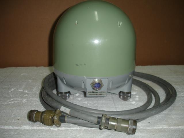
4 Taurus model Trillium 40 model STS2 model
5


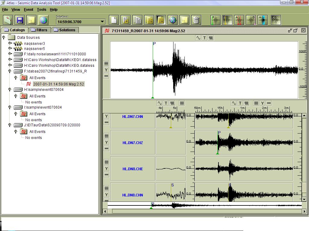
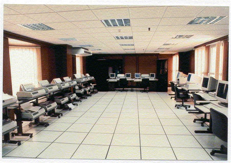
6 Analysis of seismic waveform data
7 Strong Motion Accelerometer Network (SMA) The aim of this Network : 1-Seismic hazard assessment for some regions. 2-Determination the most important parameters (PGA, PGV and PGD) that will be useful for engineering purposes.
8 ENSN Activities

9 Monitoring the Local and Regional Earthquakes The Egypt is bounded by tectonic elements: The Red Sea plate margin, African-Eurasia plate the Levant transform fault.

10 Seismicity map from (Data 10 from ENSN) Monitoring the seismic activity and seismic sources Seismicity is the distribution of earthquakes in a given area and their characteristics within a particular region. The territory of Egypt is characterized by a moderate seismic activity and by the occurrence of small to moderate intra-plate events, while the large events generally take place farther east, along the northern Red Sea or Gulf of Aqaba, and to the north, offshore the Mediterranean Sea and toward Crete and Cyprus.

11 Active Seismic Zones in and around Egypt:- 1- Coastal Zone:- This seismic zone is characterized by moderate seismic activity. Seismic activity of coastal zone of Egypt 11

12 2-Gulf of Suez seismic zone: Generally, the Gulf of Suez is characterized by low to moderate seismic activity except for its southern part near the junction. Seismic activity of Gulf of Suez 12
13 3- Gulf of Aqaba-Dead Sea seismic zone:- The Gulf of Aqaba has been affected by many destructive earthquakes. It is considered one of the most active seismic zones in Egypt. Seismic activity of Gulf of Suez 13

14 4-Dahshour seismic zone: This seismic zone is characterized by the occurrence of small to moderate magnitude earthquakes. it is considered as a relatively low seismic active zone compared to other inland areas in Egypt such as Aswan or Cairo-Suez district. The recent earthquake of 1992, October 12,is the most damaging event to be occurred in this zone., although its moderate magnitude(m b 5.8). Seismic activity of Dahshour area 14

15 5- Cairo-Suez District Zone: The Cairo-Suez shear zone represents the major seismic active inland tectonic trend in Egypt. This zone occupies two seismic active spots corresponding to Wadi Hagul and Abu Hammed; respectively. seismicity map of the Cairo-Suez district zone (Iman et al.2010) 15
16 6-Aswan seismic zone:- Aswan is one of the most important areas in Egypt. It contains Aswan High Dam (which considered as a unique structure among irrigation and electric power projects in the world), Nasser Lake (the world's second largest reservoir) and a lot of historical temples. This seismic zone is the source of the November 14, 1981 earthquake (M L 5.5) which caused considerable damages to Aswan Area. Kalabsha, Kurkur and Khour El Ramla faults are the main reasons of the seismic activity in this zone. Seismic activity of Aswan seismic zone 16
17 Other activists Monitoring the quarry and mining blasts (explosions) from cement company. The seismic hazard assessment for different regions and ground motion simulation. Shallow seismic refraction survey for different important projects (new capital city and Suez Canal).
18 Challenges (Needs) Other seismic survey (seismic reflection survey) Marine sonar and marine survey.
19 ENDC Activities Seismic Primary Array Seismic Primary 3-comp Station Seismic Auxiliary Array Seismic Auxiliary 3-comp Station Hydroacoustic (hydrophone) Station Hydroacoustic (T-phase) Station Infrasound Station Radionuclide Station Radionuclide Lab
20 Discriminate between Earthquakes and Nuclear Explosions (Ex;DPRK (North Korea) 2009) Crete, _ DPRK Explosion _ National Research Institute of Astronomy and Geophysics, Helwan,Cairo,Egypt
21 Thank you for your attention
THE WORLD BANK. Climate Change Adaptation and Natural Disasters Preparedness in the Coastal Cities of North Africa
 THE WORLD BANK Climate Change Adaptation and Natural Disasters Preparedness in the Coastal Cities of North Africa Phase 1 : Risk Assessment for the Present Situation and Horizon 2030 Alexandria Area National
Ground motion prediction from nearest seismogenic zones in and around Greater Cairo Area, Egypt
 Nat. Hazards Earth Syst. Sci., 10, 1495 1511, 2010 doi:10.5194/nhess-10-1495-2010 Author(s) 2010. CC Attribution 3.0 License. Natural Hazards and Earth System Sciences Ground motion prediction from nearest
GPS measurements of current crustal movements along the Gulf of Suez, Egypt.
 GPS measurements of current crustal movements along the Gulf of Suez, Egypt. Presented By Nadia Abo-Ali Assistant Researcher At National Research Institute of Astronomy and Geophysics (NRIAG), Helwan,
NEAR FIELD EXPERIMENTAL SEISMIC RESPONSE SPECTRUM ANALYSIS AND COMPARISON WITH ALGERIAN REGULATORY DESIGN SPECTRUM
 The th World Conference on Earthquake Engineering October -7, 8, Beijing, China NEAR FIELD EXPERIMENTAL SEISMIC RESPONSE SPECTRUM ANALYSIS AND COMPARISON WITH ALGERIAN REGULATORY DESIGN SPECTRUM N. Laouami
A STUDY OF CRUSTAL DEFORMATION ALONG THE RED SEA REGION USING GEODETIC AND SEISMIC DATA FROM EGYPT AND YEMEN
 A C T A G E O P H Y S I C A P O L O N I C A Vol. 53, No. 1 2005 A STUDY OF CRUSTAL DEFORMATION ALONG THE RED SEA REGION USING GEODETIC AND SEISMIC DATA FROM EGYPT AND YEMEN K. SAKR 1, S.M. ABDEL-MONEM
SEISMIC HAZARD ASSESSMENT AND SEISMIC SAFTY FOR THE PROPOSED ASTRONOMICAL OBSERVATORIES AT ABU TARTUR AND FAYED SITES, EGYPT
 Fourth International Conference of Earthquake Engineering and Seismology 12-14 May 2003 Tehran, Islamic Republic of Iran SEISMIC HAZARD ASSESSMENT AND SEISMIC SAFTY FOR THE PROPOSED ASTRONOMICAL OBSERVATORIES
Spectral Discrimination Between Quarry Blasts and Microearthquakes in Southern Egypt
 Research Journal of Earth Sciences 2 (1): 01-07, 2010 ISSN 1995-9044 IDOSI Publications, 2010 Spectral Discrimination Between Quarry Blasts and Microearthquakes in Southern Egypt Sayed A. Dahy and Gaber
A review of seismic hazard assessment studies and hazard description in the building codes for Egypt
 Acta Geod Geophys (2016) 51:151 180 DOI 10.1007/s40328-015-0117-5 A review of seismic hazard assessment studies and hazard description in the building codes for Egypt Rashad Sawires 1,2 José A. Peláez
The Hellenic Seismological Network of Crete (HSNC): Monitoring results and the new strong motion network
: Monitoring results and the new strong motion network") The Hellenic Seismological Network of Crete (HSNC): Monitoring results and the new strong motion network Georgios Chatzopoulos 1, Ilias Papadopoulos 1 and Filippos Vallianatos 1 1 Technological Educational
The Hellenic Seismological Network of Crete (HSNC): Monitoring results and the new strong motion network Georgios Chatzopoulos 1, Ilias Papadopoulos 1 and Filippos Vallianatos 1 1 Technological Educational
Magnitude 7.9 SE of KODIAK, ALASKA
 A magnitude 7.9 earthquake occurred at 12:31 am local time 181 miles southeast of Kodiak at a depth of 25 km (15.5 miles). There are no immediate reports of damage or fatalities. Light shaking from this
Advanced Workshop on Evaluating, Monitoring and Communicating Volcanic and Seismic Hazards in East Africa.
 2053-8 Advanced Workshop on Evaluating, Monitoring and Communicating Volcanic and Seismic Hazards in East Africa 17-28 August 2009 Seismicity of the East African Rift Atalay Ayele W. Addis Ababa University
Lateral load-deflection behaviour of single piles - An analysis of the small pile deflections
 Lateral load-deflection behaviour of single piles - An analysis of the small pile deflections Abderrazak Tharrafi 1, and Ali Bouafia 1,* 1 University Saâd Dahleb at Blida, Faculty of Technology, Dept.
TSUNAMI HAZARD ASSESSMENT IN NORTHERN EGYPT USING NUMERICAL SIMULATION
 TSUNAMI HAZARD ASSESSMENT IN NORTHERN EGYPT USING NUMERICAL SIMULATION Abutaleb Ali Supervisor: Bunichiro SHIBAZAKI MEE16717 Yushiro FUJII ABSTRACT To investigate the tsunami hazard along the northern
Abstract. 1. Introduction. Hassan, R. M., E.M. Abdelrahman, A. Tealeb, K.H. Zahran and G. Jentzsch
 Hydrological Signals due to the Seasonal Variation of Lake Nasser and its Effect to the Surrounding Crust as Deduced from the Tidal Gravity Observations Hassan, R. M., E.M. Abdelrahman, A. Tealeb, K.H.
8 th GULF SEISMIC FORUM Seismological and Earthquake Engineering studies in the Arabian Plate region March 3-6 Muscat - Oman
 Determination of Local Magnitude for Earthquake recorded by Sultanate of Oman seismological network Abdel Hafiez H.E (1),Khalil A.E. (2), El-Hussain I. (3), Deif A. (1,3) (1): National Research Institute
Gravity Observation and Crustal Deformation at Cairo Region and its Geodynamical Implications
 World Applied Sciences Journal 21 (12): 1721-1728, 2013 ISSN 1818-4952 IDOSI Publications, 2013 DOI: 10.5829/idosi.wasj.2013.21.12.721 Gravity Observation and Crustal Deformation at Cairo Region and its
Magnitude 7.0 N of ANCHORAGE, ALASKA
 A magnitude 7.0 earthquake occurred just before 8:30 am local time 8 miles north of Anchorage at a depth of 40.9 km (25.4 miles). There are reports of major infrastructure damage and damage to many homes
Seismic hazard modeling for Bulgaria D. Solakov, S. Simeonova
 Seismic hazard modeling for Bulgaria D. Solakov, S. Simeonova Bulgarian seismic network and foreign stations used in epicenter location Sismicity in Bulgaria and surroundings (M 4.) Epicentral map for
Lecture 4: Earthquakes and Seismic Waves
 Lecture 4: Earthquakes and Seismic Waves Key Questions 1. What are the sources for EQs in the PNW? 2. What is a seismograph and seismogram? 3. What is the difference between Richter magnitudes and Mercalli
REGIONAL OBSERVATIONS OF MINING BLASTS BY THE GSETT-3 SEISMIC MONITORING SYSTEM
 REGIONAL OBSERVATIONS OF MINING BLASTS BY THE GSETT-3 SEISMIC MONITORING SYSTEM Brian W. Stump and D. Craig Pearson Los Alamos National Laboratory EES-3, MS-C335 Los Alamos, NM 87545 The cessation of testing
Magnitude 7.0 PERU. This region of the Andes is a sparsely populated area, there were no immediate reports of injuries or damage.
 A magnitude 7.0 earthquake occurred in southeastern Peru on Friday about 27 kilometers northeast of the town of Azángaro, Peru, near the border with Bolivia. The earthquake occurred at a depth of 257.4
The Major Gulf of the Aqaba Earthquake, 22 November 1995 Maximum Intensity Distribution
 Natural Hazards 22: 17 27, 2000. 2000 Kluwer Academic Publishers. Printed in the Netherlands. 17 The Major Gulf of the Aqaba Earthquake, 22 November 1995 Maximum Intensity Distribution EID AL-TARAZI Department
Seismic hazard studies in Egypt
 NRIAG Journal of Astronomy and Geophysics (2012) 1, 119 140 National Research Institute of Astronomy and Geophysics NRIAG Journal of Astronomy and Geophysics www.elsevier.com/locate/nrjag Seismic hazard
overlie the seismogenic zone offshore Costa Rica, making the margin particularly well suited for combined land and ocean geophysical studies (Figure
 Chapter 1 Introduction Historically, highly destructive large magnitude (M w >7.0) underthrusting earthquakes nucleate along the shallow segment of subduction zone megathrust fault, and this region of
Building up Seismsic Models for Ground Motion Prediction of Taiwan: Problems and Challenges
 Building up Seismsic Models for Ground Motion Prediction of Taiwan: Problems and Challenges Kuo-Fong Ma 馬國鳳 Institute of Geophysics National Central University What approaches we can make toward a reliable
2008 Monitoring Research Review: Ground-Based Nuclear Explosion Monitoring Technologies
 EXTENSION OF THE CAUCASUS SEISMIC INFORMATION NETWORK STUDY INTO CENTRAL ASIA Randolph Martin 1, Mary L. Krasovec 1, Eileen Vergino 2, and M. Nafi Toksöz 3 New England Research 1, Lawrence Livermore National
Earthquake Lab Introduction: Purpose: Method: Equipment needed: Fundamental Concepts and Key Terms:
 Earthquake Lab Introduction: Seismology is that branch of the geological sciences which is concerned with the study of earthquakes. Purpose: The purpose of this exercise is to introduce some fundamental
Messa in sicurezza di edifici storici
 Messa in sicurezza di edifici storici Gian Paolo Cimellaro Associate Professor Politecnico di Torino, Italy October 31, 2016 Outline Tectonic summary; Historical seismicity; Seismic sequence; Main event
REPORT ON THE TOHOKU AREA PASIFIC OFFSHORE EARTHQUAKE
 REPORT ON THE TOHOKU AREA PASIFIC OFFSHORE EARTHQUAKE GENERAL PERSPECTIVE The Highest Magnitude Ever Recorded The 2011 off the Pacific Coast of Tohoku Earthquake (hereafter, the 2011 Tohoku- Pacific Earthquake
Digital Research Space of Induced Seismicity for EPOS Purposes (IS-EPOS project)
") Digital Research Space of Induced Seismicity for EPOS Purposes (IS-EPOS project) The project IS-EPOS (https://tcs.ah-epos.eu/) was financed from Polish structural funds (POIG.02.03.00-14-090/13-00) in
Digital Research Space of Induced Seismicity for EPOS Purposes (IS-EPOS project) The project IS-EPOS (https://tcs.ah-epos.eu/) was financed from Polish structural funds (POIG.02.03.00-14-090/13-00) in
DUBAI SEISMIC NETWORK (DSN)
") DUBAI SEISMIC NETWORK (DSN) Eman Al Khatibi 1, Kamal Abou Elenean 1 1 Dubai Municipality, Survey Department, P.O. Box: 67 Dubai U.A.E. 8 th Gulf Seismic Forum, 3-6 March 2013, Muscat-Sultanate of Oman
DUBAI SEISMIC NETWORK (DSN) Eman Al Khatibi 1, Kamal Abou Elenean 1 1 Dubai Municipality, Survey Department, P.O. Box: 67 Dubai U.A.E. 8 th Gulf Seismic Forum, 3-6 March 2013, Muscat-Sultanate of Oman
Curriculum Vitae of Prof. Hesham Hussein
 Curriculum Vitae of Prof. Hesham Hussein PERSONAL FULL NAME: Hesham Hussein Mohamed Moussa (Hussein, H.M) E-mail: DATE OF BIRTH: 23-02-1963 NATIONALITY: Egyptian. ACADEMIC QUALIFICATIONS
Important Concepts. Earthquake hazards can be categorized as:
 Lecture 1 Page 1 Important Concepts Monday, August 17, 2009 1:05 PM Earthquake Engineering is a branch of Civil Engineering that requires expertise in geology, seismology, civil engineering and risk assessment.
SEDIMENTARY BASINS Red Sea Coast of Egypt. by Prof. Dr. Abbas Mansour
 SEDIMENTARY BASINS Red Sea Coast of Egypt by Prof. Dr. Abbas Mansour Sedimentary basins Sedimentary basins are, in a very broad sense, all those areas in which sediments can accumulate to considerable
Magnitude 7.5 PALU, INDONESIA
 A magnitude 7.5 earthquake occurred 80.8 km (50.2 mi) north of Palu, Indonesia at a depth of 10 km (6.2 miles). This earthquake triggered a tsunami with wave heights up to 2 m (6.6 ft) that an official
Magnitude 7.1 PERU. There are early reports of homes and roads collapsed leaving one dead and several dozen injured.
 A magnitude 7.1 earthquake has occurred offshore Peru. The earthquake struck just after 4 a.m. local time and was centered near the coast of Peru, 40 km (25 miles) south-southwest of Acari, Peru at a depth
Land seismic sources
 Seismic Sources HOW TO GENERATE SEISMIC WAVES? Exploration seismology mostly artificial sources à active technique Natural sources can also be used (e.g. earthquakes) usually for tectonic studies (passive
Magnitude 6.9 GULF OF CALIFORNIA
 A pair of strong earthquakes struck off the coast of Mexico early Thursday only minutes apart. The magnitude 6.9 and 6.2 were centered about 85 miles northeast of Guerrero Negro in the Mexican state of
Magnitude 7.3 OFFSHORE EL SALVADOR
 A magnitude 7.3 earthquake struck off the Pacific coast of Central America late Monday night, early reports indicate one death. The earthquake occurred at a depth of 40 km (24.9 miles). Its epicenter was
NUCLEAR POWER PLANT SITE SELECTION
 NUCLEAR POWER PLANT SITE SELECTION ABDELATY B. SALMAN Ex-Chairman Nuclear Materials Authority, Cairo, Egypt I. Introduction The aim of this article is to present the requirements and characteristics for
Seismic Observation and Seismicity of Zimbabwe
 Seismic Observation and Seismicity of Zimbabwe Mr. Innocent Gibbon Tirivanhu MASUKWEDZA (2016 Global Seismology course) Meteorological Services Department of Zimbabwe 1. Introduction The Seismology section
PRELIMINARY REPORT. July 21th 2017 Bodrum Offshore Earthquake (Muğla-Turkey) Mw=6.5.
 Mw=6.5.") PRELIMINARY REPORT July 21th 2017 Bodrum Offshore Earthquake (Muğla-Turkey) Mw=6.5 www.deprem.gov.tr www.afad.gov.tr REPUBLIC OF TUKEY MANAGEMENT PRESIDENCY An earthquake with magnitude Mw=6.5 occurred
PRELIMINARY REPORT July 21th 2017 Bodrum Offshore Earthquake (Muğla-Turkey) Mw=6.5 www.deprem.gov.tr www.afad.gov.tr REPUBLIC OF TUKEY MANAGEMENT PRESIDENCY An earthquake with magnitude Mw=6.5 occurred
Alaska Earthquake Center. By Natalia A. Ruppert Seismic Network Manager
 Alaska Earthquake Center By Natalia A. Ruppert Seismic Network Manager Geophysical Institute, University of Alaska Fairbanks Alaska Earthquake Center mission and historical perspective! Regional seismic
The Earthquake of Padang, Sumatra of 30 September 2009 scientific information and update
 The Earthquake of Padang, Sumatra of 30 September 2009 scientific information and update 01-October-2009 Christophe Vigny Directeur de recherches at CNRS Laboratoire de Géologie Geoscience Dept. Of ENS,
A note on ground motion recorded during Mw 6.1 Mae Lao (Northern Thailand) earthquake on 5 May 2014
 earthquake on 5 May 2014") Proceedings of the Tenth Pacific Conference on Earthquake Engineering Building an Earthquake-Resilient Pacific 6-8 November 2015, Sydney, Australia A note on ground motion recorded during Mw 6.1 Mae Lao
Proceedings of the Tenth Pacific Conference on Earthquake Engineering Building an Earthquake-Resilient Pacific 6-8 November 2015, Sydney, Australia A note on ground motion recorded during Mw 6.1 Mae Lao
EARTHQUAKE HAZARD ASSESSMENT IN KAZAKHSTAN
 EARTHQUAKE HAZARD ASSESSMENT IN KAZAKHSTAN Dr Ilaria Mosca 1 and Dr Natalya Silacheva 2 1 British Geological Survey, Edinburgh (UK) imosca@nerc.ac.uk 2 Institute of Seismology, Almaty (Kazakhstan) silacheva_nat@mail.ru
THE NEW DIGITAL SEISMIC NETWORK IN GHANA THE WAYFORWARD AND THE CHALLENGES
 THE NEW DIGITAL SEISMIC NETWORK IN GHANA THE WAYFORWARD AND THE CHALLENGES By NICHOLAS OPOKU Seismologist, Ghana Geological Survey JANUARY, 2013 IRIS METADATA WORKSHOP - KUWAIT Seismicity / Instrumental
Earthquake patterns in the Flinders Ranges - Temporary network , preliminary results
 Earthquake patterns in the Flinders Ranges - Temporary network 2003-2006, preliminary results Objectives David Love 1, Phil Cummins 2, Natalie Balfour 3 1 Primary Industries and Resources South Australia
Probabilistic Earthquake Risk Assessment of Newcastle and Lake Macquarie Part 1 Seismic Hazard.
 Probabilistic Earthquake Risk Assessment of Newcastle and Lake Macquarie Part 1 Seismic Hazard. T. Dhu, D. Robinson, C. Sinadinovski, T. Jones, A. Jones & J. Schneider Geoscience Australia, Canberra, Australia.
EARTHQUAKE LOCATIONS INDICATE PLATE BOUNDARIES EARTHQUAKE MECHANISMS SHOW MOTION
 6-1 6: EARTHQUAKE FOCAL MECHANISMS AND PLATE MOTIONS Hebgen Lake, Montana 1959 Ms 7.5 1 Stein & Wysession, 2003 Owens Valley, California 1872 Mw ~7.5 EARTHQUAKE LOCATIONS INDICATE PLATE BOUNDARIES EARTHQUAKE
APPLICATION OF A PASSIVE TOMOGRAPHY METHOD AND CORRELATION WITH ACTIVE SEISMIC OBSERVATIONS IN THE KYPARISSIAKOS GULF, SOUTHWESTERN HELLENIC ARC
 APPLICATION OF A PASSIVE TOMOGRAPHY METHOD AND CORRELATION WITH ACTIVE SEISMIC OBSERVATIONS IN THE KYPARISSIAKOS GULF, SOUTHWESTERN HELLENIC ARC Tsambas A. 1, Fasoulaka Ch. 2, Papoulia J. 1, Makris J.
Evidence for plate tectonics
 Evidence for plate tectonics See class powerpoint Printed tables 2x essay Qs markschemes Discuss/Evaluate the evidence for plate tectonics Discuss/evaluate the evidence for plate tectonics Essay: To what
EXCITATION AND PROPAGATION OF SHORT-PERIOD SURFACE WAVES IN YOUNG SEAFLOOR. Donald W. Forsyth. Department of Geological Sciences, Brown University
 EXCITATION AND PROPAGATION OF SHORT-PERIOD SURFACE WAVES IN YOUNG SEAFLOOR ABSTRACT Donald W. Forsyth Department of Geological Sciences, Brown University Sponsored by The Defense Threat Reduction Agency
Determining the Earthquake Epicenter: Japan
 Practice Name: Hour: Determining the Earthquake Epicenter: Japan Measuring the S-P interval There are hundreds of seismic data recording stations throughout the United States and the rest of the world.
Section Forces Within Earth. 8 th Grade Earth & Space Science - Class Notes
 Section 19.1 - Forces Within Earth 8 th Grade Earth & Space Science - Class Notes Stress and Strain Stress - is the total force acting on crustal rocks per unit of area (cause) Strain deformation of materials
Magnitude 7.1 PHILIPPINES
 A magnitude 7.1 earthquake struck in the southeastern Philippines just after 8 am local time Tuesday morning killing 82 people and reducing a 17 th century church to rubble. Offices and schools were closed
The Frequency-Magnitude Distribution (FMD) by Aswan Seismic Network Earthquakes Catalog, Egypt
 by Aswan Seismic Network Earthquakes Catalog, Egypt") African Journal of Basic & Applied Sciences 4 (3): 77-82, 2012 ISSN 2079-2034 IDOSI Publications, 2012 DOI: 10.5829/idosi.ajbas.2012.4.3.64217 The Frequency-Magnitude Distribution (FMD) by Aswan Seismic
African Journal of Basic & Applied Sciences 4 (3): 77-82, 2012 ISSN 2079-2034 IDOSI Publications, 2012 DOI: 10.5829/idosi.ajbas.2012.4.3.64217 The Frequency-Magnitude Distribution (FMD) by Aswan Seismic
Kinematic Waveform Inversion Study of Regional Earthquakes in Southwest Iberia
 Kinematic Waveform Inversion Study of Regional Earthquakes in Southwest Iberia Ana Domingues Under supervision of Prof. João Fonseca and Dr. Susana Custódio Dep. Physics, IST, Lisbon, Portugal November
Detecting and Identifying Seismic Events Using the Egyptian National Seismic Network
 European Journal of Applied Sciences 4 (): 58-64, 01 ISSN 079-077 IDOSI Publications, 01 Detecting and Identifying Seismic Events Using the Egyptian National Seismic Network Sayed A. Dahy and Gaber H.
IJISET - International Journal of Innovative Science, Engineering & Technology, Vol. 2 Issue 9, September 2015.
 Prediction of petrophysical parameters applying multi attribute analysis and probabilistic neural network techniques of seismic data for Komombo Basin, Upper Egypt. Othman, A. A. A. 1, Ewida, H. F. 2,
Gravimetric Tide observation at Lake Nasser Region, Aswan, Egypt
 Gravimetric Tide observation at Lake Nasser Region, Aswan, Egypt R.M. Hassan, E.M. Abdelrahman, A. Tealeb, K.H. Zahran and G. Jentzsch ABSTRACT The LaCoste and Romberg gravimeter D-218 of the National
What is an Earthquake?
 Earthquakes What is an Earthquake? Earthquake - sometimes violent shaking of ground caused by movement of Earth s tectonic plates; creates seismic waves Often followed by smaller earthquakes (aftershocks);
Earthquake. What is it? Can we predict it?
 Earthquake What is it? Can we predict it? What is an earthquake? Earthquake is the vibration (shaking) and/or displacement of the ground produced by the sudden release of energy. Rocks under stress accumulate
BAD VIBRATIONS (Earthquakes/Tsunamis)
") Society of Exploration Geophysicists Youth Education Committee BAD VIBRATIONS (Earthquakes/Tsunamis) ACTIVITY RESOURCES Primary and Secondary (4th 12th) Includes web links on using a laptop as an oscilloscope
Society of Exploration Geophysicists Youth Education Committee BAD VIBRATIONS (Earthquakes/Tsunamis) ACTIVITY RESOURCES Primary and Secondary (4th 12th) Includes web links on using a laptop as an oscilloscope
Finding an Earthquake Epicenter Pearson Education, Inc.
 Finding an Earthquake Epicenter Measuring the Size of Earthquakes Two measurements that describe the size of an earthquake are: 1. Intensity a measure of the degree of earthquake shaking at a given locale
Magnitude 7.8 SCOTIA SEA
 A magnitude 7.8 earthquake has occurred in the South Orkney Island region in the Scotia Sea. According to the USGS, this earthquake is the latest in a series of moderate-tolarge earthquakes to strike this
A magnitude 7.4 earthquake struck 255 km (158 miles) southwest of Tonga, according to the US Geological Survey, but there were no reports of damage.
 southwest of Tonga, according to the US Geological Survey, but there were no reports of damage.") A magnitude 7.4 earthquake struck 255 km (158 miles) southwest of Tonga, according to the US Geological Survey, but there were no reports of damage. The earthquake hit at 5:19 am local time and was centered
A magnitude 7.4 earthquake struck 255 km (158 miles) southwest of Tonga, according to the US Geological Survey, but there were no reports of damage. The earthquake hit at 5:19 am local time and was centered
PROBABILISTIC SEISMIC HAZARD MAPS AT GROUND SURFACE IN JAPAN BASED ON SITE EFFECTS ESTIMATED FROM OBSERVED STRONG-MOTION RECORDS
 13 th World Conference on Earthquake Engineering Vancouver, B.C., Canada August 1-6, 2004 Paper No. 3488 PROBABILISTIC SEISMIC HAZARD MAPS AT GROUND SURFACE IN JAPAN BASED ON SITE EFFECTS ESTIMATED FROM
Statistical investigation of reservoir-induced seismicity in Aswan area, Egypt
 Earth Planets Space, 54, 349 356, 2002 Statistical investigation of reservoir-induced seismicity in Aswan area, Egypt Mahmoud Mohamed Selim 1, Masajiro Imoto 2, and Nobuo Hurukawa 1 1 International Institute
Plate Tectonics. 1)The plate tectonic system 2)A theory is born 3) Early evidence for continental drift 4) Continental drift and paleomagnetism
The plate tectonic system 2)A theory is born 3) Early evidence for continental drift 4) Continental drift and paleomagnetism") Plate Tectonics Plate boundaries 1)The plate tectonic system 2)A theory is born 3) Early evidence for continental drift 4) Continental drift and paleomagnetism 6)History and future of plate motions system
Plate Tectonics Plate boundaries 1)The plate tectonic system 2)A theory is born 3) Early evidence for continental drift 4) Continental drift and paleomagnetism 6)History and future of plate motions system
Seismic Characteristics and Mechanisms of Rockbursts
 Seismic Characteristics and Mechanisms of Rockbursts T. J. Bennett, M. E. Marshall, K. L McLaughlin, B. W. Barker and J. R. Murphy S-CUBED 11800 Sunrise Valley Dr., Suite 1212 Reston, Virginia 22091 Contract
Cascadia Seismic Event Planning for the Maritime Community
 Cascadia Seismic Event Planning for the Maritime Community Jonathan Allan, Oregon Dept. of Geology and Mineral Industries Presentation to Annual Pacific Northwest Waterways Association Meeting (PNWA) October
Measuring seismicity in the Groningen Field. Bernard Dost, Elmer Ruigrok, Jesper Spetzler, Gert-Jan van den Hazel, Jordi Domingo
 Measuring seismicity in the Groningen Field Bernard Dost, Elmer Ruigrok, Jesper Spetzler, Gert-Jan van den Hazel, Jordi Domingo Monitoring induced seismicity in the Netherlands. Instrumentation and network
Reconstruction of Subsurface Structures from Ambient Seismic Noise in Jakarta Area
 Reconstruction of Subsurface Structures from Ambient Seismic Noise in Jakarta Area Sri Widiyantoro 1 Andri Dian Nugraha 1 Zulfakriza 2 Bayu Pranata 3 1 Global Geophysics Research Group, Faculty of Mining
Magnitude 7.1 SOUTH SANDWICH ISLANDS
 A magnitude 7.1 earthquake occurred at a depth of 164.7 km (102 miles) in the South Sandwich Islands, an uninhabited British territory off the coast of Argentina in the southern Atlantic Ocean. Antarctica
Earthquake Hazards. Tsunami
 Earthquake Hazards Tsunami Measuring Earthquakes Two measurements that describe the power or strength of an earthquake are: Intensity a measure of the degree of earthquake shaking at a given locale based
Magnitude 7.7 QUEEN CHARLOTTE ISLANDS REGION
 A major 7.7 magnitude earthquake struck at 8:04 PM local time in western British Columbia, Canada. The epicenter is located on Moresby Island, the southern large island in the Queen Charlotte Islands region.
The IISEE earthquake catalog, Catalog of Damaging Earthquakes in the World, IISEE-NET,, and BRI strong motion observation
 The IISEE earthquake catalog, Catalog of Damaging Earthquakes in the World, IISEE-NET,, and BRI strong motion observation Tatsuhiko Hara International Institute of Seismology and Earthquake Engineering,
Earthquakes in Canada
 Earthquakes in Canada Maurice Lamontagne, Ph.D., ing. Geological Survey of Canada Natural Resources Canada 1 What is an Earthquake? P S P S P PS 2 2 Movement on a fault plane causes vibrations The larger
Earthquakes and seismic hazard in Sweden
 Earthquakes and seismic hazard in Sweden Björn Lund, Roland Roberts & Reynir Bödvarsson Uppsala University Outline Nordic and Swedish seismicity Comparison to plate boundary seismicity in Japan. Extrapolation
Magnitude 7.2 OAXACA, MEXICO
 A magnitude 7.2 earthquake has occurred in Oaxaca, Mexico at a depth of 24.6 km (15 miles). It was felt as far away as Guatemala. There have been no reported deaths directly linked to the earthquake. Emergency
Disclaimer. This report was compiled by an ADRC visiting researcher (VR) from ADRC member countries.
 from ADRC member countries.") Disclaimer This report was compiled by an ADRC visiting researcher (VR) from ADRC member countries. The views expressed in the report do not necessarily reflect the views of the ADRC. The boundaries and
Disclaimer This report was compiled by an ADRC visiting researcher (VR) from ADRC member countries. The views expressed in the report do not necessarily reflect the views of the ADRC. The boundaries and
The Role of Science and Technology in Earthquake Hazard Characterization: A Chilean Experience
 The Role of Science and Technology in Earthquake Hazard Characterization: A Chilean Experience STI Contribution to Policy Making on Natural Disaster Resilience APEC Workshop, 1-2 August 2018 Santiago -
Magnitude 7.6 & 7.4 SOLOMON ISLANDS
 A magnitude 7.6 earthquake struck near the Solomon Islands on Sunday morning local time; there were no immediate reports of damage. The earthquake was centered 100 km (60 miles) south of Kira Kira, a town
Bonn, Germany MOUTAZ DALATI. General Organization for Remote Sensing ( GORS ), Syria Advisor to the General Director of GORS,
, Syria Advisor to the General Director of GORS,") Bonn, Germany Early Warning System is needed for Earthquakes disaster mitigation in Syria Case Study: Detecting and Monitoring the Active faulting zones along the Afro-Arabian-Syrian Rift System MOUTAZ
Bonn, Germany Early Warning System is needed for Earthquakes disaster mitigation in Syria Case Study: Detecting and Monitoring the Active faulting zones along the Afro-Arabian-Syrian Rift System MOUTAZ
Identify a Good New Potential Zones for Hydrocarbon Reservoir Formation, Using Seismic Data
 IOSR Journal of Applied Geology and Geophysics (IOSR-JAGG) e-issn: 2321 0990, p-issn: 2321 0982.Volume 5, Issue 4 Ver. I (Jul. Aug. 2017), PP 45-52 www.iosrjournals.org Identify a Good New Potential Zones
CHARACTERISTICS OF SOURCE SPECTRA OF SMALL AND LARGE INTERMEDIATE DEPTH EARTHQUAKES AROUND HOKKAIDO, JAPAN
 13 th World Conference on Earthquake Engineering Vancouver, B.C., Canada August 1-6, 2004 Paper No. 1861 CHARACTERISTICS OF SOURCE SPECTRA OF SMALL AND LARGE INTERMEDIATE DEPTH EARTHQUAKES AROUND HOKKAIDO,
DIRECT HAZARD ANALYSIS OF INELASTIC RESPONSE SPECTRA
 DIRECT HAZARD ANALYSIS OF INELASTIC RESPONSE SPECTRA ABSTRACT Y. Bozorgnia, M. Hachem, and K.W. Campbell Associate Director, PEER, University of California, Berkeley, California, USA Senior Associate,
UNIT - 7 EARTHQUAKES
 UNIT - 7 EARTHQUAKES WHAT IS AN EARTHQUAKE An earthquake is a sudden motion or trembling of the Earth caused by the abrupt release of energy that is stored in rocks. Modern geologists know that most earthquakes
National Seismological Centre: An Overview, Prospects and Challenges
 National Seismological Centre: An Overview, Prospects and Challenges By Soma Nath Sapkota Department of Mines and Geology National Seismological Centre Nepal India Himalaya Tibetan Plateau India continental
Magnitude 7.1 NEAR THE EAST COAST OF HONSHU, JAPAN
 Japan was rattled by a strong aftershock and tsunami warning Thursday night nearly a month after a devastating earthquake and tsunami flattened the northeastern coast. This earthquake can be considered
AVERAGE AND VARIATION OF FOCAL MECHANISM AROUND TOHOKU SUBDUCTION ZONE
 13 th World Conference on Earthquake Engineering Vancouver, B.C., Canada August 1-6, 24 Paper No. 414 AVERAGE AND VARIATION OF FOCAL MECHANISM AROUND TOHOKU SUBDUCTION ZONE Shunroku YAMAMOTO 1 Naohito
Borah Peak Earthquake HAZUS Scenario Project Executive Summary Idaho Bureau of Homeland Security Idaho Geological Survey Western States Seismic
 Borah Peak Earthquake HAZUS Scenario Project Executive Summary Idaho Bureau of Homeland Security Idaho Geological Survey Western States Seismic Policy Council 12/30/2008 The HAZUS-MH analysis of the Borah
Seismic Design Criteria for the South Sinai Red Sea Rift Zone. A. I Salama Lecturer, Faculty ofengineering ofshoubra Zagazig University Egypt.
 Seismic Design Criteria for the South Sinai Red Sea Rift Zone A. I Salama Lecturer, Faculty ofengineering ofshoubra Zagazig University Egypt. Abstract The Red Sea rift zone is an area of medium to high
Probabilistic Seismic Hazard Maps in Dam Foundation
 Probabilistic Seismic Hazard Maps in Dam Foundation by Hideaki Kawasaki 1, Masafumi Kondo 2, Akira Nakamura 3, Kenji Inagaki 4 ABSTRACT Because Japan is one of the world s most earthquake prone countries,
Earthquakes and Seismotectonics Chapter 5
 Earthquakes and Seismotectonics Chapter 5 What Creates Earthquakes? The term Earthquake is ambiguous: Applies to general shaking of the ground and to the source of the shaking We will talk about both,
Overview of the Seismic Source Characterization for the Palo Verde Nuclear Generating Station
 Overview of the Seismic Source Characterization for the Palo Verde Nuclear Generating Station Scott Lindvall SSC TI Team Lead Palo Verde SSC SSHAC Level 3 Project Tuesday, March 19, 2013 1 Questions from
Earthquakes and Earthquake Hazards Earth - Chapter 11 Stan Hatfield Southwestern Illinois College
 Earthquakes and Earthquake Hazards Earth - Chapter 11 Stan Hatfield Southwestern Illinois College What Is an Earthquake? An earthquake is the vibration of Earth, produced by the rapid release of energy.
The 2016, October 26, Central Italy Earthquake Origin Time 17:10:36 UTC, M L(ISNet) =5.3; M W(ISNet) =5.6
 =5.3; M W(ISNet) =5.6") The 2016, October 26, Central Italy Earthquake Origin Time 17:10:36 UTC, M L(ISNet) =5.3; M W(ISNet) =5.6 RISSC-Lab: Laboratorio di RIcerca in Sismologia Sperimentale e Computazionale The event as seen
The 2016, October 26, Central Italy Earthquake Origin Time 17:10:36 UTC, M L(ISNet) =5.3; M W(ISNet) =5.6 RISSC-Lab: Laboratorio di RIcerca in Sismologia Sperimentale e Computazionale The event as seen
Tan K. Wang National Taiwan Ocean University, Keelung, Taiwan, R.O.C.
 SEISMIC IMAGING IN THE OCEANS Tan K. Wang National Taiwan Ocean University, Keelung, Taiwan, R.O.C. Keywords: Converted wave, multi-channel seismic, ocean-bottom seismometer, travel-time inversion, virtual