Seismic Monitoring for Geothermal plants
|
|
|
- Alexander Shelton
- 5 years ago
- Views:
Transcription


1 Seismic Monitoring for Geothermal plants

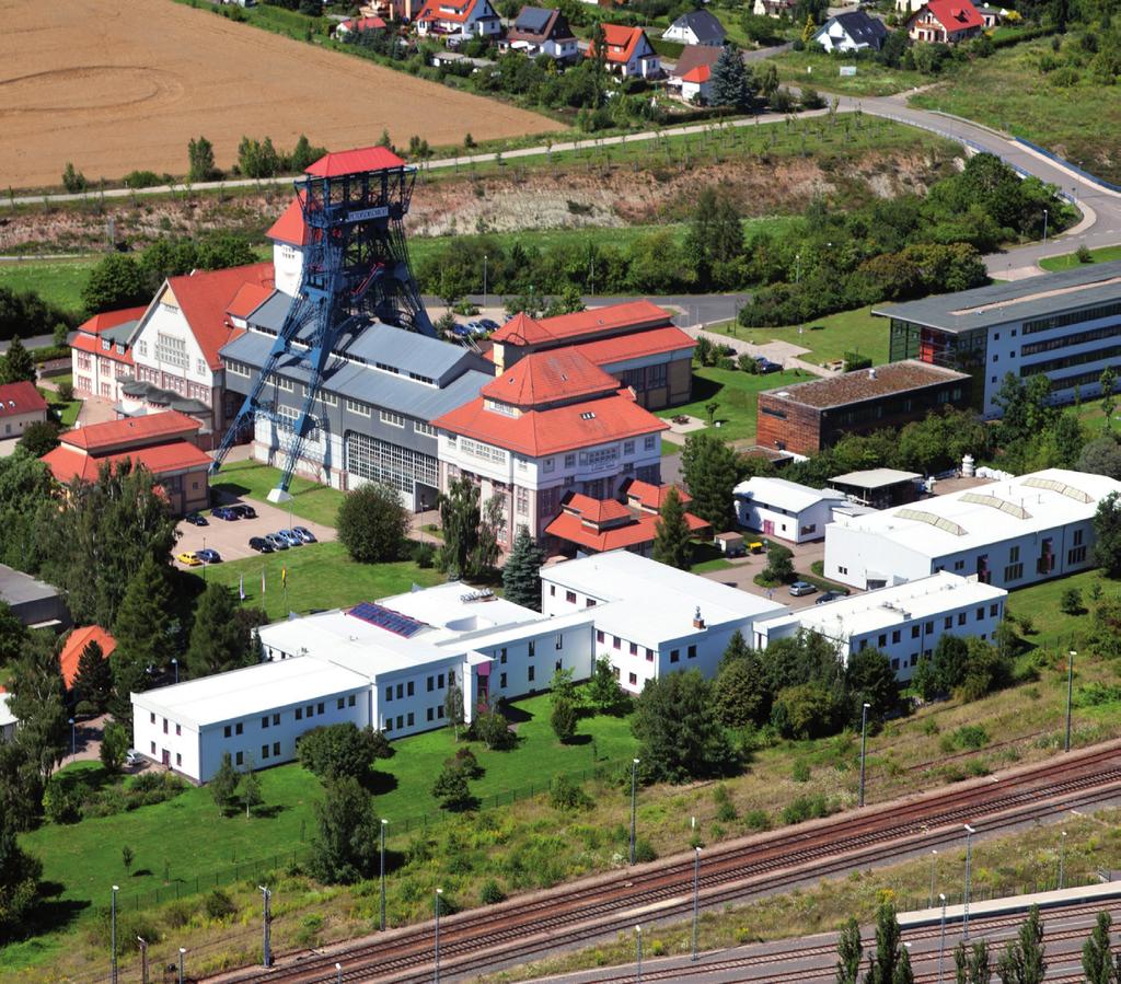
2 Seismic Monitoring Geothermal plants Why seismic monitoring: Seismic events, whether they are caused by local tectonics, fracturing of the overburden or induced by local mining or fracturing in the underground, are only sporadically occurring events, thus the assessment of the general within an area can only be realised over a longer period of time. These events can occur spontaneously or artificially induced (i.e. fracking of lithological layers for geothermal plants). K-UTEC has a long lasting experience within this subject and offers extensive support both in planning and installing seismic monitoring systems but we also offer extensive assistance for the operation of the moni- toring system, the interpretation of the single events as well as the general assessment of the in the target area. K-UTEC is able to design always the best fit and individual solution for each costumer. With help of these information it is possible to react to the seismic events. Geothermal plant companies can use these information for detecting areas with higher permeabilities and fractures in the ground. It is also possible to react if the local increases in a certain area. Furthermore if seismic vibrations occur the measurements can show if the critical values of the authorities were exceeded. Localization of events and estimation of the event parameters Seismic Monitoring System Design of the monitoring system: Measurement of the vibration Arrival time Event location (x,y,z) Event time Seismic Monitoring Geophysics establish seismic monitoring systems design the best solution for the costumer compute the accuracy of the system in the observed area build up the system in the field operate seismic monitoring systems locate seismic events and evaluate the seismic data automatic location and alerting manual control of the localization calculation of the event and seismological parameters status report in time intervals as desired by the client 4G mobile data network (LTE) WLAN daily control of the monitoring system maintenance of the system updating of the system, in case of changing local conditions Ethernet The seismic monitoring system or vibration measurement system can be build up on the surface or in mines. The seismometers can be installed on the surface, in boreholes or in the mine. Specialist for the field of seismic monitoring: EurGeol. Grad. Geophysicist Thomas Schicht Phone: Fax: geophysik@k-utec.de


3 Seismic Monitoring Geothermal plants Design of a single station Various types of seismometers indoor 3D Seismometers Transient recorder Power supply GPS Antenna-cable outdoor with 220 V power supply GPS Antenna LTE Antenna 1D Seismometers Transient recorder Power supply uninterrupted power supply unit Accelerators Borehole seismometers Hydrophones with Solar power supply LTE Antenna GPS Antenna Power supply Solar panel Transient recorder power supply buffer battery ATEX seismometer


4 Seismic Monitoring Geothermal plants Event Example Raw data of a seismic event Automatic Localization Automatically marked arrival times Software packages: SeismoSuite and SeismoLocal


5 Seismic Monitoring Geothermal plants Manual Localization Marked arrival times Manual Localization ans visualization Marked events on the map Graphical implementation of site and mine plants
: 2013 a new concept for aseismologic registration")
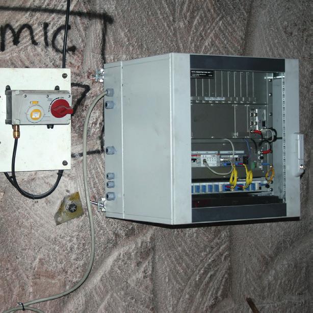
6 Seismic Monitoring Geothermal plants Scheme of the event processing Seismic Event Recorder Daily function and event control Automatic Triggering/ Recording Seismogram Automatic localization and. estimation of the seismic energ if magnitude exceeds the maximum permissible value Technical characteristics of the transient recorder (basic system): 2013 a new concept for aseismologic registration unit was carried out by the K-UTEC AG Salt Technologies. The background of the concept was to develop a device for high resolution data (24 Bit) high sampling rates (5 khz each channel), time synchronisation (GPS module) and the ability to use modern median for data transfer (internal 4G modem downward compatible, internal LAN port, WLAN hotspot, and more). The power supply is very low with less than 6 W. For this reason it is possible to supply the data recorder by solar power in the field. The K-UTEC Geolog is able to work together with different sensors like velocity proportional seismometers, accelerators, piezoelectrical pressure transducers and more. The K-UTEC GeoLog is useable for: - Qualifying of seismic events - Alerting by specified parameters - Long-time monitoring of geoscientific parameters - Mobile and permanent data logging, monitoring and documentation manual post processing and correction Automatic alert by , SMS etc. Notification of the correction complex evaluation/ report Event location, Magnitude, Event parameter, Intensity, results Characteristics - Flexible external sensors with different parameters: accelerations, vibration velocities, pressure and more - Internal mobile LTE modem - Individual data cloud and Server application - Up to 64 GByte internal storage, with 24 Bit resolution and 5 khz sampling rate - 4 to 8 channels with time synchronized sampling - modular extendable - Internal mathematical calculation options - Remote maintenance and remote-software-update with watchdog Miscellaneous - Temperature range -40 to +70 C - Compact ALU-Housing 45 mm x 85 mm x 164 mm - Integrated self-sufficient system monitoring (watchdog) - Low power input (2,5 W without LTE modem, 6 W with LTE modem)
7 References actual in seismic monitoring by K-UTEC Project Location / Client Size Year Remarks Installation of a seismic monitoring system natural and induced induced and natural natural and induced induced and natural induced and natural Monitoring of natural natural and induced during brine process induced and natural natural seismic activity induced and natural natural Installation of the seismic monitoring system in a radioactive waste mine natural the explosive compaction activities the former lignite opencast pits areas a former lignite opencast pit the vibroflotation soil compaction activities a cavern field a geothermal plant Unterbreizbach- Merkers-Wintershall / K+S, Teutschenthal, Angersdorf and Salzmünde / GTS mbh, Bleicherode / NDH-E mbh, Sondershausen / GSES mbh, Bischofferode / LMBV KSE (former GVV mbh), Sollstedt / NDH-E mbh, Zielitz / K+S, Staßfurt / LAGB, Velenje / Premogovnik Velenje, Slovenia Bernburg / esco, Kirchheilingen / VGS, Volkenroda / LMBV KSE (former GVV mbh), Salzbergwerk Stetten / Wacker Chemie GmbH, Morsleben / DBE Boulby Mine / ICL, UK Lausitz / LMBV, Lausitz / LMBV, Schlabendorf / LMBV, Nachterstedt / LMBV, Hengelo / Akzo Nobel, The Netherlands Poing / Markt Schwabach Bayernwerke Natur GmbH point to vibration monitoring stations Since 1970s Since 1985 Since 1994 Since 1994 Since 1995 Since 1995 renewed accordin Since (and before) 2010 Since 1998, rebuild 2016 Since 2000 Since 2001 Since 2002 since 2002 Since 2005, rebuilt 2016 Since 2009 Since 2012 Since 2013 Since 2014 Since 2015 Since 2015 in extension Since 2016 in extension installation of a seismic monitoring system, technical support, consulting the mine deposit, control of natural and induced, control and guidance of deposit work the mine deposit, control of induced and natural, control and guidance of deposit work the mine deposit, control of natural and induced, control and guidance of deposit work induced and natural, monitoring of non-controlled flooding the mine deposit, control of mining induced, control and guidance of deposit work monitoring of natural, technical support natural and induced during brine process Seismic monitoring, control of induced and natural for a lignite mine natural Vibration measurement (monitoring of seismic activity in the area of gas storage caverns) induced and natural, monitoring of non-controlled flooding the mine deposit, control of natural Seismic monitoring, control of induced and natural Seismic monitoring, control of induced and natural the explosive compaction activities in several areas in the former lignite opencast pit area the former lignite opencast pits area the former lignite opencast pit Schlabendorf-South the vibroflotation soil compaction activities in a former lignite opencast pit area a cavern field a geothermal plant with an increasing number of wells


")

8 Seismic Monitoring Geothermal plants K-UTEC AG Salt Technologies Am Petersenschacht Sondershausen Phone +49 (0) Fax +49 (0) Mail info@k-utec.com Web
THE NEW DIGITAL SEISMIC NETWORK IN GHANA THE WAYFORWARD AND THE CHALLENGES
 THE NEW DIGITAL SEISMIC NETWORK IN GHANA THE WAYFORWARD AND THE CHALLENGES By NICHOLAS OPOKU Seismologist, Ghana Geological Survey JANUARY, 2013 IRIS METADATA WORKSHOP - KUWAIT Seismicity / Instrumental
Geotechnical Engineering and Dams
 Geotechnical Engineering and Dams Solving Geotechnical Challenges for Hydropower and Water Resources Projects Geological and geotechnical challenges are often very demanding when planning hydraulic structures.
LOG_aLevel. Tsunami Warning System
 LOG_aLevel Tsunami Warning System General Acoustics e.k. Am Kiel-Kanal 1 24106 Kiel Germany Phone: +49 431 5 80 81 80 www.generalacoustics.com Info@generalacoustics.com LOG_aLevel Tsunami Warning System
MetConsole AWOS. (Automated Weather Observation System) Make the most of your energy SM
 Make the most of your energy SM") MetConsole AWOS (Automated Weather Observation System) Meets your aviation weather needs with inherent flexibility, proven reliability Make the most of your energy SM Automated Weather Observation System
MetConsole AWOS (Automated Weather Observation System) Meets your aviation weather needs with inherent flexibility, proven reliability Make the most of your energy SM Automated Weather Observation System
Underground Storage & Disposal - The Salt Concept. Thomas Brasser - GRS
 Underground Storage & Disposal - The Salt Concept Thomas Brasser - GRS Who is GRS ( Plant & Reactor Safety Ltd. ) Non-profit, independent expert and research organisation Assess and improve safety of technical
High-precision NATM tunnelling through advanced surveying and monitoring technology. Klaus Rabensteiner
 High-precision NATM tunnelling through advanced surveying and monitoring technology Klaus Rabensteiner Introduction to Geodata www.geodata.com Activities o o o o Surveying Monitoring Instrumentation Software
Best selling products overview of company AURA a.s.
 Best selling products overview of company AURA a.s. The most frequent areas of application of AURA a. s. products Petrol industry Mines and mining industry Metallurgy and heavy industry Deliveries for
DS 300. Electronic Pressure Switch. with IO-Link interface. Stainless Steel Sensor. accuracy according to IEC 60770: 0.35 % FSO.
 DS 00 Electronic Pressure Switch with IO-Link interface Stainless Steel Sensor accuracy according to IEC 60770: 0.5 % FSO Nominal pressure from 0... 00 mbar up to 0... 600 bar Digital output signal IO-Link
WeatherHub2 Quick Start Guide
 WeatherHub2 Quick Start Guide Table of Contents 1 Introduction... 1 2 Packing List... 1 3 Connections... 1 4 IP Addressing... 2 5 Browser Access... 3 6 System Info... 3 7 Weather Station Settings... 4
General Information: Real-time onsite solar forecasting
 General Information: Real-time onsite solar forecasting Introduction The Fulcrum3D CloudCAM system is a robust, turn-key cloud detection and solar forecasting system, targeted at optimal management of
Advanced Technologies in digital 3D-Surface, -Deposit und -Mine- Modelling
 8 th Jordanien International Mining Conference 19.09. to 21.09.2017 Ammann - Jordan Natural Resources: Projected Investment, Reality and Aspirations Dr.-Ing. Marc Dohmen, Aachen Dohmen, Herzog & Partner
SEISMIC SURVEYS FOR IMAGING THE REGOLITH
 SEISMIC SURVEYS FOR IMAGING THE REGOLITH Barry Drummond Geoscience Australia. PO Box 378, Canberra, ACT 2601. E-mail: barry.drummond@ga.gov.au 1. INTRODUCTION Seismic reflection and refraction imaging
IMS4 ARWIS. Airport Runway Weather Information System. Real-time data, forecasts and early warnings
 Airport Runway Weather Information System Real-time data, forecasts and early warnings Airport Runway Weather Information System FEATURES: Detection and prediction of runway conditions Alarms on hazardous
_ LANDSLIDES AND SLOPE STABILITY APPLICATION NOTES
 _ LANDSLIDES AND SLOPE STABILITY APPLICATION NOTES LANDSLIDES AND SLOPE STABILITY The term landslide describes a wide variety of processes that result in the downward and outward movement of slope-forming
Seismic Observation and Seismicity of Uganda
 (Uganda, Mr. Nyago Joseph, 2012-2013S) Seismic Observation and Seismicity of Uganda 1. Seismic observation in Uganda In 1989, UNESCO and the International Programs in Physical Sciences (IPPS) donated four
Tecnomatix Plant Simulation Worldwide User Conference 2016 FLEXIBILIZATION STUDY OF MATERIAL AND ENERGY FLOWS IN MINING
 FLEXIBILIZATION STUDY OF MATERIAL AND ENERGY FLOWS IN MINING Dr. Hans Rüdiger Lange Innovationsregion Lausitz GmbH Johannes Stoldt Fraunhofer-Institut für Werkzeugmaschinen und Umformtechnik 1 AGENDA Motivation
Non-Acoustical Inputs
 CHAPTER 18 Non-Acoustical Inputs This chapter discusses the use of external transducers and devices to provide non-acoustical data to the Model 831. Included are the following: 831-INT 831-INT Interface
Smart Sensing Embedded Spectroscopy Platform Botlek studiegroep 06-april-2017
 Smart Sensing Embedded Spectroscopy Platform Botlek studiegroep 06-april-2017 W. Karremans Personal introduction Background: Process Analysis DSM AKZO Nobel Chemicals Aspenpharma 2016: Sales Engineer Elscolab
CORS911: REAL-TIME SUBSIDENCE MONITORING OF THE NAPOLEONVILLE SALT DOME SINKHOLE USING GPS
 CORS911: REAL-TIME SUBSIDENCE MONITORING OF THE NAPOLEONVILLE SALT DOME SINKHOLE USING GPS LSU Center for GeoInformatics Joshua D. Kent & Larry E. Dunaway 29 th Annual Louisiana Remote Sensing & GIS Workshop
Regulatory Considerations for Evaluating the Potential for Induced Seismicity of a Class I Non-Hazardous Disposal Well
 Regulatory Considerations for Evaluating the Potential for Induced Seismicity of a Class I Non-Hazardous Disposal Well Chad Milligan, P.G.-SCS Engineers Craig Pangburn, P.G.-T&C Consulting Many Options
POTASH DRAGON CHILE GEOPHYSICAL SURVEY TRANSIENT ELECTROMAGNETIC (TEM) METHOD. LLAMARA and SOLIDA PROJECTS SALAR DE LLAMARA, IQUIQUE, REGION I, CHILE
 METHOD. LLAMARA and SOLIDA PROJECTS SALAR DE LLAMARA, IQUIQUE, REGION I, CHILE") POTASH DRAGON CHILE GEOPHYSICAL SURVEY TRANSIENT ELECTROMAGNETIC (TEM) METHOD LLAMARA and SOLIDA PROJECTS SALAR DE LLAMARA, IQUIQUE, REGION I, CHILE OCTOBER 2012 CONTENT Page I INTRODUCTION 1 II FIELD
POTASH DRAGON CHILE GEOPHYSICAL SURVEY TRANSIENT ELECTROMAGNETIC (TEM) METHOD LLAMARA and SOLIDA PROJECTS SALAR DE LLAMARA, IQUIQUE, REGION I, CHILE OCTOBER 2012 CONTENT Page I INTRODUCTION 1 II FIELD
Comprehensive Winter Maintenance Management System BORRMA-web MDSS inside to increase Road Safety and Traffic Flow
 Thorsten Cypra 1 Comprehensive Winter Maintenance Management System BORRMA-web MDSS inside to increase Road Safety and Traffic Flow American Public Works Association (APWA) Monday, 04/14/2008 3:30 4:30
Weather Stations. Evaluation copy. 9. Post live weather data on the school s web site for students, faculty and community.
 Weather Stations Computer P6 Collecting and analyzing weather data can be an important part of your Earth Science curriculum. It might even be an ongoing part of your entire course. A variety of activities
Innovations in Airborne Exploration Geophysics. Benedikt Steiner
 Innovations in Airborne Exploration Geophysics Benedikt Steiner What is exploration geophysics? 2 The use of the Earth s physical properties in locating geological features of interest to mining. Magnetics,
THE METEOROLOGICAL DATA QUALITY MANAGEMENT OF THE ROMANIAN NATIONAL SURFACE OBSERVATION NETWORK
 THE METEOROLOGICAL DATA QUALITY MANAGEMENT OF THE ROMANIAN NATIONAL SURFACE OBSERVATION NETWORK Ioan Ralita, Ancuta Manea, Doina Banciu National Meteorological Administration, Romania Ionel Dragomirescu
Lufft Ceilometer Series
 Lufft Ceilometer Series Lufft CHM 15k and CHM 8k a passion for precision passion pour la précision pasión por la precisión passione per la precision www.lufft.com Lufft Ceilometer Series // 1 Lufft Ceilometers
GEOMATICS. Shaping our world. A company of
 GEOMATICS Shaping our world A company of OUR EXPERTISE Geomatics Geomatics plays a mayor role in hydropower, land and water resources, urban development, transport & mobility, renewable energy, and infrastructure
Lima Project: Seismic Refraction and Resistivity Survey. Alten du Plessis Global Geophysical
 Lima Project: Seismic Refraction and Resistivity Survey Alten du Plessis Global Geophysical Report no 0706/2006 18 December 2006 Lima Project: Seismic Refraction and Resistivity Survey by Alten du Plessis
Flash flood forecasting and warning infrastructures of National Meteorology and Hydrological Services of Cambodia
 Development and Implementation of the South East Asia Flash Flood Guidance System (SEAFFGS) Ha Noi, Viet Nam, 20-23 November 2017 Flash flood forecasting and warning infrastructures of National Meteorology
Device Specifications
 Manual Device Specifications PART NUMBER LCGATEWAY ELECTRICAL The Lightcloud Gateway is designed to be hard-wired to AC power by a qualified electrician. INPUT 120-277 VAC, 50/60 Hz 60-45mA BATTERY Li-ion
VMS-GeoMil. Background
 Background When using a drilling rig for cone penetration testing, a mechanical clamp can be mounted to the drilling head (by means of a special transition piece). The depth than can be achieved depends
Complete Weather Intelligence for Public Safety from DTN
 Complete Weather Intelligence for Public Safety from DTN September 2017 White Paper www.dtn.com / 1.800.610.0777 From flooding to tornados to severe winter storms, the threats to public safety from weather-related
Seismicity in Pennsylvania and the Pennsylvania State Seismic Network (PASEIS)
") Seismicity in Pennsylvania and the Pennsylvania State Seismic Network (PASEIS) Andy Nyblade Department of Geosciences, Penn State University May 19, 2017 Shale Network Workshop Introduction Review of historic
Seismicity in Pennsylvania and the Pennsylvania State Seismic Network (PASEIS) Andy Nyblade Department of Geosciences, Penn State University May 19, 2017 Shale Network Workshop Introduction Review of historic
Geotechnical Monitoring for Safe Excavation of Large Rock Cavern: A Case Study
 The 31st International Symposium on Automation and Robotics in Construction and Mining (ISARC 2014) Geotechnical Monitoring for Safe Excavation of Large Rock Cavern: A Case Study A.Mandal a, C. Kumar b,
Certificate: / 30. April 2015
 Test report: 936/21226418/A of 29 September 2014 Initial certification: 2. April 2015 Date of expiry: 1. April 2020 Publication: BAnz AT 02 April 2015 B5, chapter III number 3.1 Approved application The
TexNet and CISR: An Update on Monitoring and Understanding Seismicity in Texas
 TexNet and CISR: An Update on Monitoring and Understanding Seismicity in Texas Michael H. Young a, Alexandros Savvaidis a, Peter Hennings a, Ellen Rathje b a Bureau of Economic Geology, Jackson School
Electronic Supplementary Material Mine Water and the Environment
 Electronic Supplementary Material Mine Water and the Environment In-Lake Neutralization: Quantification and Prognoses of the Acid Load into a Conditioned Pit Lake (Lake Bockwitz, Central Germany) Kai-Uwe
DMP 331. Industrial Pressure Transmitter for Low Pressure. Stainless Steel Sensor
 DMP Industrial Pressure Transmitter for Low Pressure Stainless Steel Sensor accuracy according to IEC 60770: : 0.5 % FSO option: 0.5 / 0. % FSO Nominal pressure from 0... 00 mbar up to 0... 60 bar Output
ADI 2040 Process Analyzer
 ADI 2040 Process Analyzer Multi-purpose wet chemical analysis Multi-purpose Wet Chemical Analysis ADI 2040 The Metrohm Applikon ADI 2040 Process Analyzer is a multipurpose wet chemical analyzer, that has
Technical Drafting, Geographic Information Systems and Computer- Based Cartography
 Technical Drafting, Geographic Information Systems and Computer- Based Cartography Project-Specific and Regional Resource Mapping Services Geographic Information Systems - Spatial Analysis Terrestrial
INFLUENCE OF MINING ACTIVITY ON THE INTEGRITY OF SALT FORMATIONS AS CANDIDATE HOST ROCKS FOR NUCLEAR REPOSITORIES
 INFLUENCE OF MINING ACTIVITY ON THE INTEGRITY OF SALT FORMATIONS AS CANDIDATE HOST ROCKS FOR NUCLEAR REPOSITORIES K. Wieczorek, R. Miehe, T. Rothfuchs GRS-Final Repository Safety Research Division 38011
TUNNEL SEISMIC WHILE DRILLING STATE OF THE ART AND NEW DEVELOPMENTS
 TUNNEL SEISMIC WHILE DRILLING STATE OF THE ART AND NEW DEVELOPMENTS Mr. Werner Chwatal, Vienna University of Technology, Austria, wchwatal@mail.tuwien.ac.at Mr. Alexander Radinger, Pöyry Infra GmbH, Austria,
Icing prediction on blade wind turbine using forecast data
 Icing prediction on blade wind turbine using forecast data From Antoine Amossé, instrumentation and control Engineer Summary 1. Context & Challenge 2. Data integration and algorithm 3. Results 4. Conclusion
personal weather station
 personal weather station Master your own climate measurements on your smartphone TRAINING BOOK Pitch The Netatmo Personal Weather Station helps you master your own climate measurements on your smartphone.
Solar Radiation and Solar Programs. Training Consulting Engineering Publications GSES P/L
 Solar Radiation and Solar Programs Training Consulting Engineering Publications SOLAR RADIATION Purposes of Solar Radiation Software Successful project planning and solar plant implementation starts by
Moroccan lightning detection network, topology, performance and management of the network
 Moroccan lightning detection network, topology, performance and management of the network Mohamed DAHOUI, Mohamed NBOU and Rabia MERROUCHI Moroccan Meteorological Center Tel (212)71302837, Fax: (212)22908593
Expert paper GIS CONTENT PROPOSAL FOR UNDERGROUND MINING ROOMS
 UNDERGROUND MINING ENGINEERING 14 (2005) 95-100 UDK 62 FACULTY OF MINING AND GEOLOGY, BELGRADE YU ISSN 0354-2904 ABSTRACT Expert paper GIS CONTENT PROPOSAL FOR UNDERGROUND MINING ROOMS Milutinović Aleksandar
GROUND ACOUSTIC PENETRATION
 GROUND ACOUSTIC PENETRATION Bronislav A. Koulmametiev and Boris V. Matveev InterGeoRAP Consulting. 8 Hartleap Lane, Beldon, WA 6027. E-mail: tchern@iinet.net.au 1. DESCRIPTION Ground Acoustic Penetration
WeatherWatcher ACP. Astronomers Control Panel (V4 or >) Ambient Virtual Weather Station (Pro or Internet editions) ASCOM platform v4.
 Ambient Virtual Weather Station (Pro or Internet editions) ASCOM platform v4.") WeatherWatcher ACP Software This is a minimum equipment list: Astronomers Control Panel (V4 or >) Ambient Virtual Weather Station (Pro or Internet editions) ASCOM platform v4.1 or higher Hardware Weather
WeatherWatcher ACP Software This is a minimum equipment list: Astronomers Control Panel (V4 or >) Ambient Virtual Weather Station (Pro or Internet editions) ASCOM platform v4.1 or higher Hardware Weather
ELITE-CO2CABIN. Extinguishing for electrical panels. Brochure and specifications
 ELITE-CO2CABIN DIRECT ACTION Brochure and specifications INDIRECT ACTION ELITE-C02CABIN (DIRECT) BENEFITS Quick anasy installation Easy maintenance Quick anasy cleaning Reduced system >> No need of large
Ultrasonic Measuring System for Deposition of Sediments in Reservoirs
 MECAHITECH 11, vol. 3, year: 011 Ultrasonic Measuring System for Deposition of Sediments in Reservoirs M. Mărgăritescu* 1, A. Moldovanu * 1, P. Boeriu *, A.M.E. Rolea* 1 * 1 National Institute of Research
Vaisala AviMet Automated Weather Observing System
 Vaisala AviMet Automated Weather Observing System Solutions to meet your challenges Our mission: to help you operate succesfully Safe, economical, reliable and flexible operation of your airport is ensured
The next generation in weather radar software.
 The next generation in weather radar software. PUBLISHED BY Vaisala Oyj Phone (int.): +358 9 8949 1 P.O. Box 26 Fax: +358 9 8949 2227 FI-00421 Helsinki Finland Try IRIS Focus at iris.vaisala.com. Vaisala
Lufft MARWIS-UMB Mobil Advanced Road Weather Information Sensor
 Lufft MARWIS-UMB Mobil Advanced Road Weather Information Sensor sion for precision passion pour la précision pasión por la precisión passione per la precisione a passion www.lufft.com/wondermadeingermany
Quantum Series Product Catalog
 Measuring and Managing Healthy Living Quantum Series Product Catalog RJL Sciences is an FDA registered company RJL Sciences, Inc. 33939 Harper Avenue Clinton Township, MI 48035 USA Voice: 1-800-528-4513
LOZAR RADAR INTRODUCTORY PRESENTATION COAL SURVEYING
 LOZAR RADAR INTRODUCTORY PRESENTATION COAL SURVEYING WWW.LOZARRADAR.COM ABOUT LOZAR RADAR Lozar Radar is a ground-scanning device, which verifies and investigates the presence of mineral resources and
Empowering water/wastewater network management with GIS
 Empowering water/wastewater network management with GIS Ioannis Kavouras_GIS Manager Surveying Engineer, MSc, MBA The Company responsible for fresh water distribution & sanitation serving 1.500.000 citizens
BOXA-II ON-STREAM X-RAY FLUORESCENCE ANALYZER. Technical Description Version 2 BGRIMM AUTOMATION
 BOXA-II ON-STREAM X-RAY FLUORESCENCE ANALYZER Technical Description Version 2 BGRIMM AUTOMATION, South 4th Ring Road West, Beijing, China TEL: +86(10)59069762 Fax: +86(10)68360101 Contents BGRIMM AUTOMATION
SEISMIC SURVEY METHODS
 SEISMIC SURVEY METHODS Seismic methods Seismic surveys are used in geology and geotechnical engineering to: a) define the depth of the bedrock; b) investigate the landslide areas, c) check the structural
Progress Report No Norwegian National Seismic Network
 Progress Report No. 1-2005 for Norwegian National Seismic Network January 1 st to June 30 th, 2005. Supported by University of Bergen, Faculty of Mathematics and Natural Sciences and Norwegian Oil Industry
Edgetech Instruments Inc.
 2015_07_ETI OVERVIEW Rev 3 MADE IN THE USA Edgetech Instruments (ETI) is a USA company based in Massachusetts. We have over 50 years of expertise in the design and manufacture of a comprehensive range
DMP 331P. Industrial Pressure Transmitter. Process Connections With Flush Welded Stainless Steel Diaphragm
 DMP P Industrial Pressure Transmitter Process Connections With Flush Welded Stainless Steel accuracy according to IEC 60770: standard: 0.5 % FSO option: 0.5 % FSO Nominal pressure from 0... 00 mbar up
xlogic SuperRelay is a compact and expandable CPU replacing mini PLCs, multiple timers, relays and counters.
 SuperRelay S U P E R R E L A Y, T H E P E R F E C T A L T E R N A T I V E T O L O W C O S T P L C s A N D B A S I C R E L A Y S I N T H I S B R O C H U R E : ELC 18 Standard Models ELC 18 Economy Models
AWOS. Automated Weather Observing Systems COASTAL
 AWOS Automated Weather Observing Systems COASTAL Environmental Systems Monitor Monitor Your Your World World Coastal s Experience & Expertise Since 1981, Coastal Environmental Systems, Inc. (Coastal) has
Data Acquisition System for Photovoltaic Water Pumping System in the Desert of Tunisia
 Available online at www.sciencedirect.com Procedia Engineering 33 (2012) 268 277 ISWEE 11 Data Acquisition System for Photovoltaic Water Pumping System in the Desert of Tunisia Ammar Mahjoubi*, Ridha Fethi
Land seismic sources
 Seismic Sources HOW TO GENERATE SEISMIC WAVES? Exploration seismology mostly artificial sources à active technique Natural sources can also be used (e.g. earthquakes) usually for tectonic studies (passive
Finding out what earthquakes have happened recently Subscribe to an alert system
 Finding out what earthquakes have happened recently Subscribe to an email alert system Hosted by the United States Geological Survey http://earthquake.usgs.gov/eqcenter/ens/ USGS USGS Once registered you
Airborne Geophysical Survey Report River Jordan Property
 Airborne Geophysical Survey Report River Jordan Property Prepared for: Inc. September 3, 2009 Precision GeoSurveys Inc. 520-355 Burrard Street, Vancouver, Canada V6C 2G8 www.precisiongeosurveys.com Table
Ridracoli Dam: surveillance and safety evaluation reported on internet page
 Ridracoli Dam: surveillance and safety evaluation reported on internet page P.P. MARINI; P. BALDONI; F. FARINA; F. CORTEZZI - Romagna Acque, Forlì, Italy A. MASERA - Enel.Hydro, ISMES Division, Bergamo,
Web GIS & ArcGIS Pro. Zena Pelletier Nick Popovich
 Web GIS & ArcGIS Pro Zena Pelletier Nick Popovich Web GIS Transformation of the ArcGIS Platform Desktop Apps GIS Web Maps Web Scenes Layers Evolution of the modern GIS Desktop GIS (standalone GIS) GIS
WEATHER STATION FOR SOLAR FARM MONITORING
 WEATHER STATION FOR SOLAR FARM MONITORING SOLAR FARM MONITORING SYSTEM: Measures global, horizontal, & background irradiance. Measures wind speed, wind direction, ambient temperature, and relative humidity.
Mercury Stack Monitor SM-4
 Member of the envea Group Mercury Stack Monitor SM-4 Automatic continuous emission monitor (CEM) for mercury Continuous operation Sample dilution directly at stack - works with virtually any sample matrix
Lamp and Control Panel (Lamp Panel)
") www.reinhausen.com Lamp and Control Panel (Lamp Panel) Operating Instructions BA 47/0 EN NOTE! Changes may have been made to a product after going to press with this documentation. We expressly reserve
www.reinhausen.com Lamp and Control Panel (Lamp Panel) Operating Instructions BA 47/0 EN NOTE! Changes may have been made to a product after going to press with this documentation. We expressly reserve
Absolute strain determination from a calibrated seismic field experiment
 Absolute strain determination Absolute strain determination from a calibrated seismic field experiment David W. Eaton, Adam Pidlisecky, Robert J. Ferguson and Kevin W. Hall ABSTRACT The concepts of displacement
CERTIFICATE of Product Conformity (QAL1 )
") ATÜVRheinlancl Precisely Right. CERTIFICATE of Product Conformity (QAL1 ) Certificate No.: 0000040212 01 Certified AMS: Manufacturer: Test lnstitute: Fidas 200 S respectively Fidas 200 for particulate
ATÜVRheinlancl Precisely Right. CERTIFICATE of Product Conformity (QAL1 ) Certificate No.: 0000040212 01 Certified AMS: Manufacturer: Test lnstitute: Fidas 200 S respectively Fidas 200 for particulate
WS-9018U Wireless Weather Station. Instruction Manual
 WS-9018U Wireless Weather Station Instruction Manual Contents Page 1. Functions of the Weather Station....3 2. Safety notes...3 3. Product features....4 4. Getting started....4 5. Quick Set Up...5 6. Setting
Lufft MARWIS-UMB Mobil Advanced Road Weather Information Sensor
 Lufft MARWIS-UMB Mobil Advanced Road Weather Information Sensor www.lufft.com/wondermadeingermany Professional Mobile Weather Data Recording. Forget black holes in your weather forecast. You waste too
Certificate: / 29 April 2014
 Test report: 936/21218896/A of 20 September 2013 Initial certification: 01 April 2014 Date of expiry: 31 March 2019 Publication: BAnz AT 01 April 2014 B12, chapter IV, No. 5.1 Approved application The
Acceleration/Velocity/Displacement VIBRATION METER
 Acceleration/Velocity/Displacement VIBRATION METER Model : VB-8220 Your purchase of this VIBRATION METER marks a step forward for you into the field of precision measurement. Although this METER is a complex
The EarthScope Geophysical Observatories. Slides courtesy Bob Woodward, Incorporated Research Institutions for Seismology (IRIS)
") The EarthScope Geophysical Observatories Slides courtesy Bob Woodward, Incorporated Research Institutions for Seismology (IRIS) 1 EarthScope Project Study the four dimensional structure and evolution of
The EarthScope Geophysical Observatories Slides courtesy Bob Woodward, Incorporated Research Institutions for Seismology (IRIS) 1 EarthScope Project Study the four dimensional structure and evolution of
National Earthquake Monitoring for Tsunami Early Warning. Burin Wechbunthung Sumalee Prachaub Seismological Bureau, Thai Meteorological Department
 National Earthquake Monitoring for Tsunami Early Warning Burin Wechbunthung Sumalee Prachaub Seismological Bureau, Thai Meteorological Department Seismic Sources Out line Historical Earthquake Damage from
POSSIBILITY FOR APPLICATION OF GIS TECHNOLOGIES IN RTB BOR GROUP
 MINING AND METALLURGY INSTITUTE BOR UDK: 622 ISSN: 2334-8836 (Štampano izdanje) ISSN: 2406-1395 (Online) UDK: 681.33:622.343(045)=111 doi:10.5937/mmeb1603021v Nenad Vušović *, Marko Vuković **, Igor Svrkota
Design of Safety Monitoring and Early Warning System for Buried Pipeline Crossing Fault
 5th International Conference on Civil Engineering and Transportation (ICCET 2015) Design of Safety Monitoring and Early Warning System for Buried Pipeline Crossing Fault Wu Liu1,a, Wanggang Hou1,b *, Wentao
Digital Research Space of Induced Seismicity for EPOS Purposes (IS-EPOS project)
") Digital Research Space of Induced Seismicity for EPOS Purposes (IS-EPOS project) The project IS-EPOS (https://tcs.ah-epos.eu/) was financed from Polish structural funds (POIG.02.03.00-14-090/13-00) in
Digital Research Space of Induced Seismicity for EPOS Purposes (IS-EPOS project) The project IS-EPOS (https://tcs.ah-epos.eu/) was financed from Polish structural funds (POIG.02.03.00-14-090/13-00) in
Wellsite Consulting Services Diversified Well Logging LLC. All Rights Reserved.
 Wellsite Consulting Services We are CUSTOMER FOCUSED: We seek to exceed customer expectations by providing solutions that improve their drilling, completions, and production economics OUR CORE VALUES DEFINE
Low Cost Seismic Monitoring Strategies
 Low Cost Seismic Monitoring Strategies Derrick J. Chambers Mining Engineer Spokane Mining Research Division NIOSH Research Team: Shawn Boltz, Derrick Chambers, Dave Hanson, Sean Johnson, Jerry Richardson,
Ultrasonic Gas Flow Meter
 P r o d u c t i n f o r m at i o n FLOWSIC600 Ultrasonic Gas Flow Meter For custody transfer and process applications Analyzers and Process Instrumentation FLOWSIC600 For Custody Transfer and Process Applications
MANAGEMENT OF THE NIEMEN RIVER BASIN WITH ACCOUNT OF ADAPTATION TO CLIMATE CHANGE. Hydro-meteorological Monitoring System
 MANAGEMENT OF THE NIEMEN RIVER BASIN WITH ACCOUNT OF ADAPTATION TO CLIMATE CHANGE Hydro-meteorological Monitoring System Draft Interim Report Milestone 1 Giovanni Crema 18 October 2012 Scope of work assessment
IMS4 AWOS. Automated Weather Observation System. Integrates all airport weather data
 Integrates all airport weather data IMS4 AWOS FEATURES: Integrates all airport weather data Scalable up to ICAO category CAT III Conforms to the ICAO and WMO regulations and recommendations AWOS data on
iweathar EDGE V Installation Guide Copyright 2012 iweathar. All rights reserved.
 iweathar EDGE V Installation Guide Copyright 2012 iweathar. All rights reserved. Table of contents: 1 Introduction...3 2 Station Components...4 3 STATION INSTALLATION PROCEDURE...5 4 Specifications...11
ractical Geomechanics for Oil & Gas Industry
 P ractical Geomechanics for Oil & Gas Industry Practical Geomechanics for Oil and Gas Industry The integrity of the wellbore plays an important role in petroleum operations including drilling, completion
Location of Marmara Sea Earthquakes Using Marmara Sea Bottom Observatories (MSBO) and Land Stations
 and Land Stations") Location of Marmara Sea Earthquakes Using Marmara Sea Bottom Observatories (MSBO) and Land Stations Cemil GÜRBÜZ (1), Doğan KALAFAT (1), Mehmet YILMAZER (1), Suleyman TUNÇ (2), Sezim GUVERCIN (1) (1) Boğaziçi
Location of Marmara Sea Earthquakes Using Marmara Sea Bottom Observatories (MSBO) and Land Stations Cemil GÜRBÜZ (1), Doğan KALAFAT (1), Mehmet YILMAZER (1), Suleyman TUNÇ (2), Sezim GUVERCIN (1) (1) Boğaziçi
Grimsel In-situ Stimulation and Circulation experiment: First results SCCER Annual meeting , Birmensdorf, Switzerland
 Grimsel In-situ Stimulation and Circulation experiment: First results SCCER Annual meeting 14 15.09.2017, Birmensdorf, Switzerland J. Doetsch, F. Amann, V. Gischig, M. Jalali, H. Krietsch, B. Valley, C.
Determination of the coefficient of earth pressure at rest in situ in overconsolidated clay
 World Tunnel Congress 2008 - Underground Facilities for Better Environment and Safety - India Determination of the coefficient of earth pressure at rest in situ in overconsolidated clay Eszter Kalman Budapest
Professional Weather. For Emergency. Professional. For. Emergency. Weather Stations. Stations. Responders. Professional Weather Stations.
 Professional Weather Stations Professional Professional Weather Weather Stations Stations For For For For Emergency Emergency Responders Responders Monitor Your World WEATHERPAK MTR On-site, real-time
The influence of drilling process automation on improvement of blasting works quality in open pit mining
 The influence of drilling process automation on improvement of blasting works quality in open pit mining Maciej Bodlak 1, Dominik Dmytryk 2, Piotr Mertuszka 3,*, Marcin Szumny 3, and Grzegorz Tomkiewicz
NOVALYNX CORPORATION MODEL 110-WS-16BP BAROMETRIC PRESSURE SENSOR INSTRUCTION MANUAL
 NOVALYNX CORPORATION MODEL 110-WS-16BP BAROMETRIC PRESSURE SENSOR INSTRUCTION MANUAL REVISION DATE: OCT 2005 Receiving and Unpacking Carefully unpack all components and compare to the packing list. Notify
Geothermal power generation in the Upper Rhine Valley The Project Offenbach/Pfalz
 Geothermal power generation in the Upper Rhine Valley The Project Offenbach/Pfalz Horst Kreuter, Norman Harthill, Michael Judt and Bodo Lehmann Email: kreuter@hotrock.de, lehmann@dmt.de, harthill@hotrock.de,
Website Phone Mobile OVERVIEW Davis Vantage Pro2 Weather Station
 OVERVIEW If you're looking for a superior weather station, the Davis Vantage Pro2 Weather Station is as good as they come! Vantage Pro2 offers the professional weather observer and the serious weather
National Geophysical Survey Science Opportunities
 National Geophysical Survey Science Opportunities Anton Ziolkowski Professor of Petroleum Geoscience University of Edinburgh BGS Keyworth 4 April 2016 Outline Brief biography Science opportunities High