National Earthquake Monitoring for Tsunami Early Warning. Burin Wechbunthung Sumalee Prachaub Seismological Bureau, Thai Meteorological Department
|
|
|
- Georgiana Carter
- 6 years ago
- Views:
Transcription
1 National Earthquake Monitoring for Tsunami Early Warning Burin Wechbunthung Sumalee Prachaub Seismological Bureau, Thai Meteorological Department
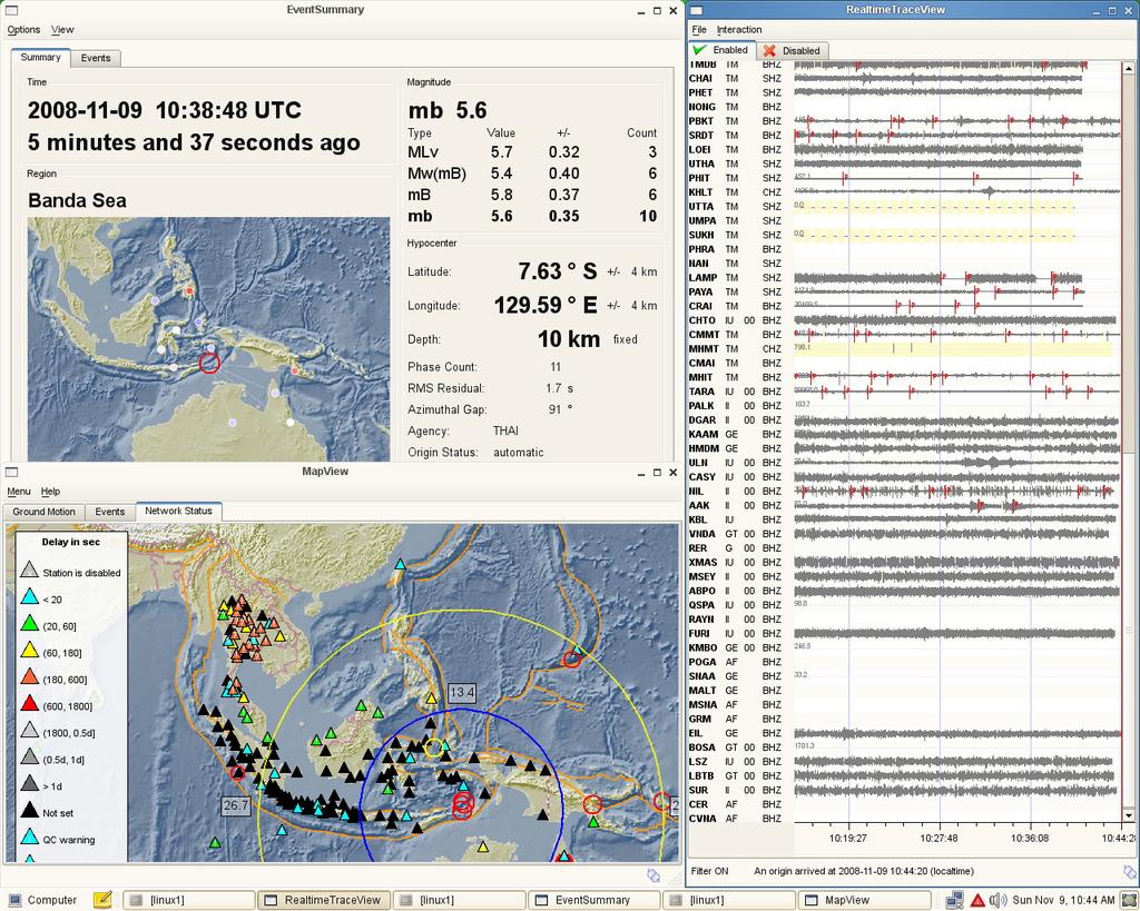
2 Seismic Sources Out line Historical Earthquake Damage from Earthquake Seismic Monitoring Network -Stations,sensors,link,data processing,analysis,desemination Capacity of epicenter determination
3
4
5
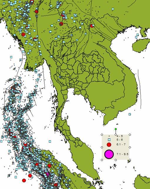
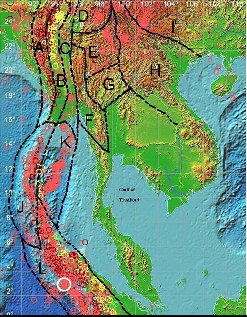
6 Maximum Intensity Historical record ~1500 years ago MM is about X in Northern Part Instrumental Record 1935 Ml 6.5 in Northern Part 1983 Ml 5.9 in Western Part
7 Development of seismic network in Thailand WWSSN were set up in Chiangmai and Songkhla Analog Stations (SP 1Hz) Digital Stations (2 SP 3BB) Digital Stations from 2 phase installation First phase primary stations consist of 7 (Trillium120),8(Trillium 120),15 (TSA110) Second Phase consist of 15 (S-13),10(KS-2000M),25(PA23),1(KS2000BH),2(PA23BH)
8
9
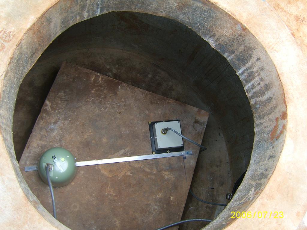
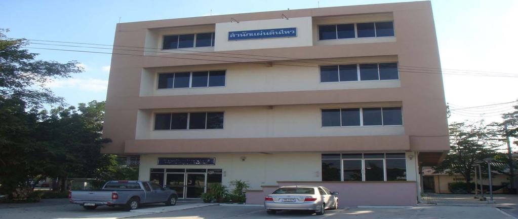
10 Thai National Seismic Monitoring Network Primary Stations Phase 1(15 STA) Phase II(25 Sta) -Seismometer,Accelerometers,Data Logger,Communication link in real time(vsat,ipstar,adsl) Stand alone Accelerograph stations(26 sta) 2 Bore hole Stations at TMD in Bangkok Seismic Monitoring Center at Seismological Bureau,Thai Meteorological Department, automatic EQ determination software
11 Backup system More stations, several transmission data channels (IP star, ADSL,VSAT) 2 internet providers 2 acquisition servers, 2 Graphic user interface servers,3 automatic EQ Determination software(earlybird,smartquake,seiscomp3) 3-4 Fax machines 2 UPS+Diesel Electricity generator
12 AFTER 2004 Tsunami ADSL IPSTAR TMD Seismic Network 15 Automatic Seismic stations are operated at present. Plus 25 station will operate in 2008 (Red Triangles) ADSL IPSTAR ADSL
13

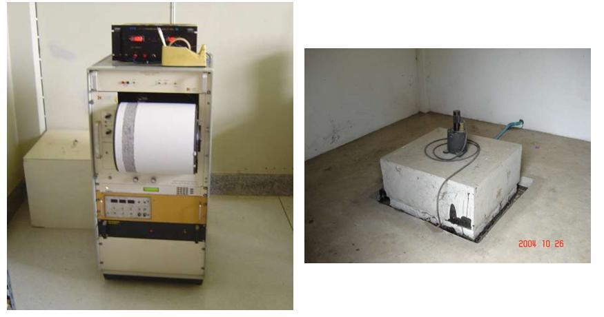
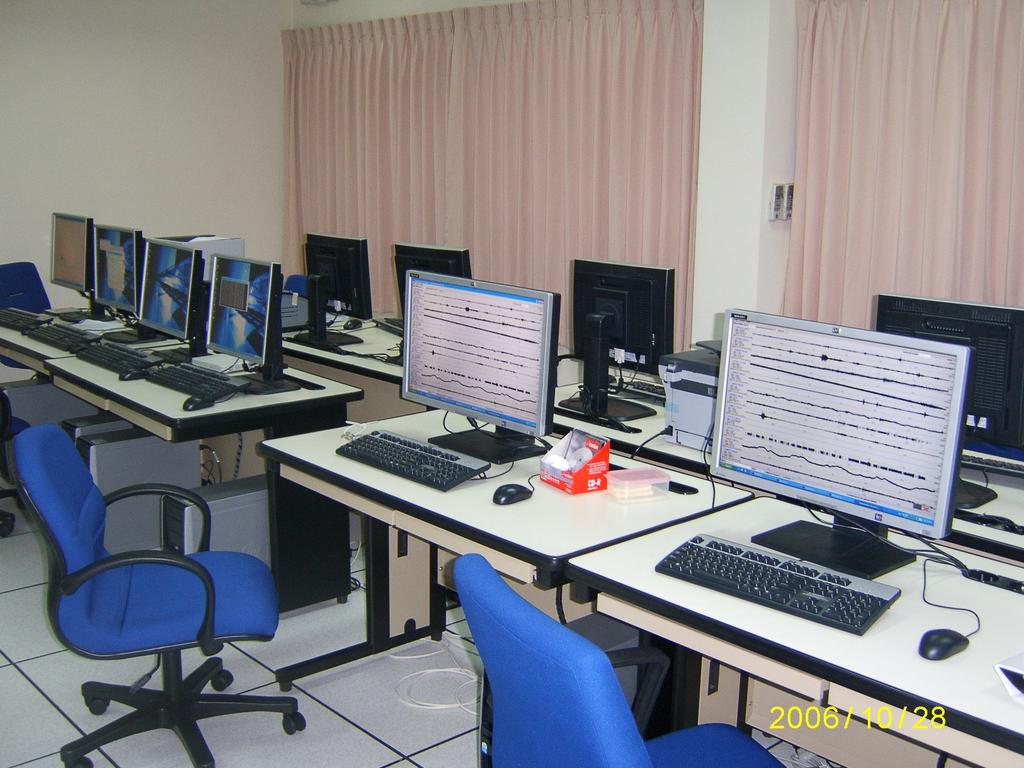
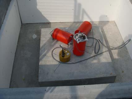
14 Velocity Sensors Data logger Accelerometer


15 Srinakarind Dam Broadband+Stongmotion Accelerograph Khaolaem Dam Short period+sma Dam Sites of EGAT
16
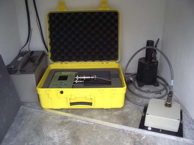


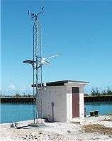
17 Accelerograph station


18


19 Satellite Router TMD Bangkok Router Remote Stations PHASE I Seismic Network 15 Stations
20


21 Real time monitoring Analysis software Seismological Bureau Bangkok
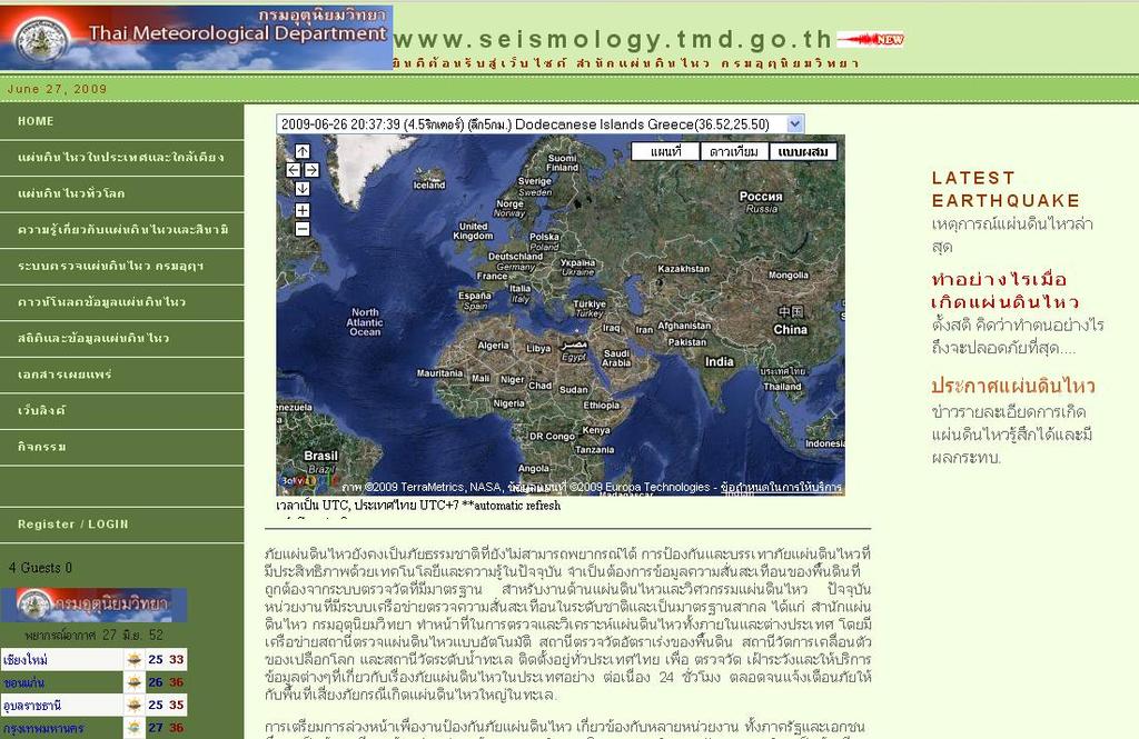
22 Earthquake Monitoring Diagram Seismic Stations Data Exchange Digital GEOFON TMD 24/7 VSAT,Internet IRIS,LISS SMS, Cralwing text in TV Analysis and Verify Tsunami (Magnitude, Epicenter, Depth) Announce Mass Media, AGENCIES Felt Earthquake in Thailand Website Public
23 15 Seismic Stations IPstar, ADSL In Phase 1 30 Seismic stations from Indonesia,Malaysia, Australia,Africa,Japan, Taiwan,Srilanka EARTH WORM Data Processing Internet 2 NAQ Servers Data Processing 15 Sta EARLYBIRD AUTOMATIC DETERMINATION For Regional Earthquake realtime TMD WEB 2 Offline server ATLAS Local EQ Annoucement Voice ALARM Location Map in Google Earth Refresh every 2 min Seedlink server IRIS LISS SERVER USERS

24 Link Data from other countries
25
26 25 Seismic Stations IPstar, ADSL In Phase 2 15 Seismic Stations In Phase 1 NAQ SERVER GEOHUB Servers Data Processing 2 Offline server SEISPLUS Local EQ 20 Seismic stations from Indonesia,Malaysia, Australia,Africa,Japan, Taiwan,Srilanka SLINK IRIS SMARTQUAKE AUTOMATIC DETERMINATION For Regional Earthquake Voice ALARM Annoucement Phase II

27
28

29
30
31 25 Seismic Stations IPstar, ADSL In Phase 2 Seedlink Server Data Processing 15 Seismic Stations In Phase 1 40 Seismic stations from Indonesia,Malaysia, Australia,Africa,Japan, Taiwan,Srilanka, Geofon Network NAQ SERVER SLINK Geofon,IRIS SEISCOMP 3 AUTOMATIC DETERMINATION For Local and Regional Earthquakes Seedlink Server Opened Real time data Voice ALARM Annoucement
32
33 Regional Earthquakes can be determined by Thai Seismic Monitoring Network Andaman,Sumatra,Indian Ocean (~5-10 Mins) Southwest Pacific,South China Sea, Phillipines,Papua New Guinea,Tonga (~5-12 Mins) Australia,New Zealand (~15-18 Mins) Neigbouring countries: Indonesia,Malaysia,Myanmar,Laos Vietnam, S China,(~3-12 Mins) North and South America (~20 Mins)

 20")


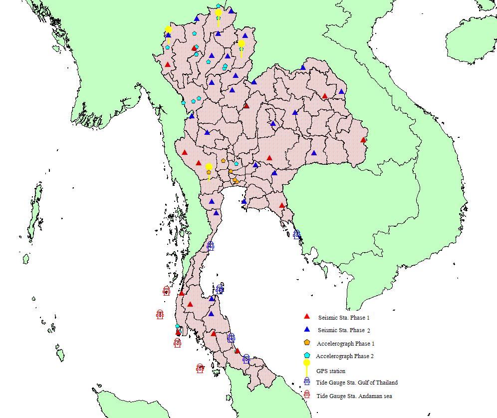
34 Phase II 25 seismic stations (10BB,15 SP) 20 Acceleration stations 2 Borehole stations 4 GPS stations 9 Tide Gauge stations Project will finish in 2009

35 PHASE I SEISMIC STATION 15 STRONG MOTION 6 PHASE II SEISMIC STATION 25 STRONG MOTION 20 GPS STATION 4 BOREHOLE STATION 2 TIDE GAUGE STATION 9

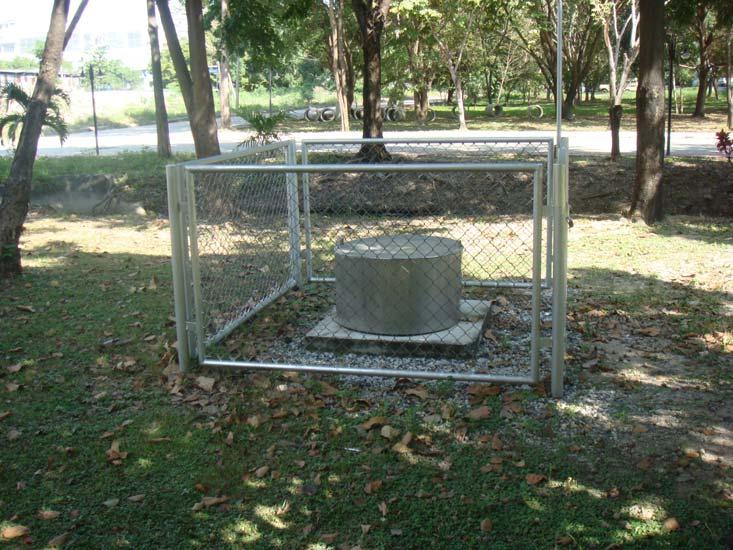
36 Tide Gauge Station at Ranod Songkhla
37 Research work in seismology and Earthquake Engineering,Tsunami Data base compilation of earthquake data and Tsunami -Historical data and instrumental data plus focal mechanism compilation -Trenching Fault in the northern and western part -Dynamic response of building response in Bangkok -Micro tremor analysis in Bangkok area -Paleotsunagenic Research in the southern part
38 Strategy to face with TSUNAMI More Sharing RT Data and significant information Seismic data, Earthquake information, warning message,tide Level and Bouy data More capacity building By various assistance from organization :USAID,GFZ,USGS,IOC,IRIS,CEA etc. More knowledgement public would know well what and how to do when natural disaster occurs.
39 Conclusion Progress for rapid EQ determination Ability of sharing EQ data in RT More cooperation with agencies networks regarding to EQ and Tsunami Need more developmet for tsunami early warning system i.e. tsunami modeling, inundation, SOP, dissemination etc

40 THANK YOU
Formulation of the Strategy for Disaster Risk Reduction and Emergency Preparedness and Response of the Asia-Pacific Region
 2008/SOM3/TFEP/SEM/006 Formulation of the Strategy for Disaster Risk Reduction and Emergency Preparedness and Response of the Asia-Pacific Region 2009-2015 Submitted by: Thailand Emergency Management CEOs
Earthquake,Tsunami,Volcano Monitoring & Warning System in Korea. Jimin Lee Earthquake & Volcano Monitoring Division KMA
 Earthquake,Tsunami,Volcano Monitoring & Warning System in Korea Jimin Lee Earthquake & Volcano Monitoring Division KMA 1 2 Brief History & Vision of KMA Introduction of Services 3 Korea National Seismographic
LOG_aLevel. Tsunami Warning System
 LOG_aLevel Tsunami Warning System General Acoustics e.k. Am Kiel-Kanal 1 24106 Kiel Germany Phone: +49 431 5 80 81 80 www.generalacoustics.com Info@generalacoustics.com LOG_aLevel Tsunami Warning System
IGUT Seismic Network. Institute of Geophysics University of Tehran (IGUT) Mehdi Rezapour
 Mehdi Rezapour") IGUT Seismic Network Institute of Geophysics University of Tehran (IGUT) Mehdi Rezapour History of seismic monitoring in Iran The IGUT starts to record & Locate seismic events in the 1960 s using 5 WWSSN
IGUT Seismic Network Institute of Geophysics University of Tehran (IGUT) Mehdi Rezapour History of seismic monitoring in Iran The IGUT starts to record & Locate seismic events in the 1960 s using 5 WWSSN
Seismic and Tsunami Observations of Indonesia
 (Indonesia, Mr. Fatchurochman Iman, 2010-2011S, Mr. Dwi Hartanto/Mr. Tatok Yatimantoro, 2011-2012T) Seismic and Tsunami Observations of Indonesia 1. Seismic Monitoring Agency for Meteorology, Climatology
National seismological network of Serbia
 Seismological Survey of Serbia National seismological network of Serbia 1 Seismological Survey of Serbia consist of two networks: SEISMOLOGICAL NETWORK ACCELERATION NETWORK 2 Spatial distribution of seismological
Flash flood forecasting and warning infrastructures of National Meteorology and Hydrological Services of Cambodia
 Development and Implementation of the South East Asia Flash Flood Guidance System (SEAFFGS) Ha Noi, Viet Nam, 20-23 November 2017 Flash flood forecasting and warning infrastructures of National Meteorology
Establishment and Operation of a Regional Tsunami Warning Centre
 Establishment and Operation of a Regional Tsunami Warning Centre Dr. Charles McCreery, Director NOAA Richard H. Hagemeyer Pacific Tsunami Warning Center Ewa Beach, Hawaii USA Why A Regional Tsunami Warning
Indian Ocean Tsunami Warning System: Example from the 12 th September 2007 Tsunami
 Indian Ocean Tsunami Warning System: Example from the 12 th September 2007 Tsunami Charitha Pattiaratchi 1 Professor of Coastal Oceanography, The University of Western Australia Email: chari.pattiaratchi@uwa.edu.au
SCIENCE OF TSUNAMI HAZARDS
 SCIENCE OF TSUNAMI HAZARDS ISSN 8755-6839 Journal of Tsunami Society International Volume 32 Number 1 2013 THE FRENCH TSUNAMI WARNING CENTER FOR THE MEDITERRANEAN AND NORTHEAST ATLANTIC: CENALT P. Roudil,
Location of Marmara Sea Earthquakes Using Marmara Sea Bottom Observatories (MSBO) and Land Stations
 and Land Stations") Location of Marmara Sea Earthquakes Using Marmara Sea Bottom Observatories (MSBO) and Land Stations Cemil GÜRBÜZ (1), Doğan KALAFAT (1), Mehmet YILMAZER (1), Suleyman TUNÇ (2), Sezim GUVERCIN (1) (1) Boğaziçi
Location of Marmara Sea Earthquakes Using Marmara Sea Bottom Observatories (MSBO) and Land Stations Cemil GÜRBÜZ (1), Doğan KALAFAT (1), Mehmet YILMAZER (1), Suleyman TUNÇ (2), Sezim GUVERCIN (1) (1) Boğaziçi
IRIS WORKSHOP, Out of Africa
 IRIS WORKSHOP, Out of Africa Adapting the Africa Array Model Building Capacity Around the Worl Boston,18-19 February 2008 BMG Fauzi@bmg.go.id Meteorologocal and Geophysical Agency Jl. Angkasa I.No.2, Kemayoran
JMA Tsunami Warning Services. Takeshi KOIZUMI Senior Coordinator for International Earthquake and Tsunami Information Japan Meteorological Agency
 JMA Tsunami Warning Services Takeshi KOIZUMI Senior Coordinator for International Earthquake and Tsunami Information Japan Meteorological Agency Tectonic Setting of Japan (Headquarters for Earthquake Research
Report for 15th PCGIAP Meeting at 18th UNRCC-AP Working Group 1 Regional Geodesy
 Report for 15th PCGIAP Meeting at 18th UNRCC-AP Working Group 1 Regional Geodesy Chairman Shigeru Matsuzaka, Japan - shigeru@gsi.go.jp Vice Chairman Prof. Pengfei Cheng, China - chengpf@casm.ac.cn John
JMA Tsunami Warning Services. Tomoaki OZAKI Senior Coordinator for Tsunami Forecast Modeling Japan Meteorological Agency
 JMA Tsunami Warning Services Tomoaki OZAKI Senior Coordinator for Tsunami Forecast Modeling Japan Meteorological Agency Organization Chart of the Government of Japan Cabinet Office Diet Ministry of Internal
Dense Ocean floor Network System for Earthquakes and Tsunamis DONET
 Dense Ocean floor Network System for Earthquakes and Tsunamis DONET Yoshiyuki Kaneda Japan Agency for Marine-Earth Science and Technology (JAMSTEC) ION 1 Earthquakes in the Nankai Trough Tokai Nankai Hyuga
Tsunami detection component: discussion about the existing network and real-time data processing. Begoña Pérez Gómez, Puertos del Estado, Spain
 Tsunami detection component: discussion about the existing network and real-time data processing Begoña Pérez Gómez, Puertos del Estado, Spain Outline Marine network: role within TWS s NEAMTWS overview
METEOROLOGICAL WARNINGS STUDY GROUP (METWSG)
") METWSG/4-SN No. 6 12/3/12 METEOROLOGICAL WARNINGS STUDY GROUP (METWSG) FOURTH MEETING Montréal, 15 to 18 May 2012 Agenda Item 6: Wind shear, turbulence and tsunami warnings TSUNAMI INFORMATION (Presented
METWSG/4-SN No. 6 12/3/12 METEOROLOGICAL WARNINGS STUDY GROUP (METWSG) FOURTH MEETING Montréal, 15 to 18 May 2012 Agenda Item 6: Wind shear, turbulence and tsunami warnings TSUNAMI INFORMATION (Presented
Seismic Observation and Seismicity of Uganda
 (Uganda, Mr. Nyago Joseph, 2012-2013S) Seismic Observation and Seismicity of Uganda 1. Seismic observation in Uganda In 1989, UNESCO and the International Programs in Physical Sciences (IPPS) donated four
Real Time Monitoring System for Megathrust Earthquakes and Tsunamis - Cabled Network System and Buoy System in Japan -
 Real Time Monitoring System for Megathrust Earthquakes and Tsunamis - Cabled Network System and Buoy System in Japan - 1 Subduction zones around the world Haiti Italy Turkey Tohoku Sichuan Taiwan Sumatra
Real time Monitoring System for Earthquakes and Tsunamis (DONET)
") Real time Monitoring System for Earthquakes and Tsunamis (DONET) NankaiTrough Yoshiyuki Kaneda Japan Agency for Marine-Earth Science and Technology (JAMSTEC) POGO@Seoul Presentation 1 Earthquakes in the
Real time Monitoring System for Earthquakes and Tsunamis (DONET) NankaiTrough Yoshiyuki Kaneda Japan Agency for Marine-Earth Science and Technology (JAMSTEC) POGO@Seoul Presentation 1 Earthquakes in the
Progress Report. Flood Hazard Mapping in Thailand
 Progress Report Flood Hazard Mapping in Thailand Prepared By: Mr. PAITOON NAKTAE Chief of Safety Standard sub-beuro Disaster Prevention beuro Department of Disaster Prevention and Mitigation THAILAND E-mail:
REAL-TIME ASSESSMENT OF EARTHQUAKE DISASTER IN YOKOHAMA BASED ON DENSE STRONG-MOTION NETWORK
 REAL-TIME ASSESSMENT OF EARTHQUAKE DISASTER IN YOKOHAMA BASED ON DENSE STRONG-MOTION NETWORK Saburoh MIDORIKAWA 1 And Susumu ABE 2 SUMMARY This paper describes a system for REal-time Assessment of earthquake
National Public Weather and Warning Services in the Swaziland Meteorological Service Dennis S.Mkhonta /
 National Public Weather and Warning Services in the Swaziland Meteorological Service Dennis S.Mkhonta dennis.mkhonta@gmail.com / dennis@swazimet.gov.sz Introduction Swaziland s geographical position exposes
Design of Safety Monitoring and Early Warning System for Buried Pipeline Crossing Fault
 5th International Conference on Civil Engineering and Transportation (ICCET 2015) Design of Safety Monitoring and Early Warning System for Buried Pipeline Crossing Fault Wu Liu1,a, Wanggang Hou1,b *, Wentao
THE NEW DIGITAL SEISMIC NETWORK IN GHANA THE WAYFORWARD AND THE CHALLENGES
 THE NEW DIGITAL SEISMIC NETWORK IN GHANA THE WAYFORWARD AND THE CHALLENGES By NICHOLAS OPOKU Seismologist, Ghana Geological Survey JANUARY, 2013 IRIS METADATA WORKSHOP - KUWAIT Seismicity / Instrumental
SOP of PTWC as a Regional Tsunami Service Provider
 UNESCO IOC CTIC US NOAA ITIC Regional Training Workshop on Strengthening Tsunami Warning and Emergency Response Standard Operating Procedures and the Development of the ICG/CARIBE-EWS PTWC New Enhanced
Sentinel Asia Tsunami Working Group
 Sentinel Asia Tsunami Working Group Co-Chairman: Prof. Shunichi Koshimura Abdul Muhari, PhD 4 th Joint Project Team Meeting (JPTM 2017): Sentinel Asia STEP 3 Abdul MUHARI, PhD Ministry of Marine Affairs
Impacts of 2014 Chiangrai Earthquake from Geotechnical Perspectives
 EIT-JSCE Joint International Symposium on Human Resource Development for Disaster-Resilient Countries 214 Impacts of 214 Chiangrai Earthquake from Geotechnical Perspectives Suttisak Soralump 1, Jessada
Data Sharing at the National Research Institute for Earth Science and Disaster Resilience
 Data Sharing at the National Research Institute for Earth Science and Disaster Resilience Katsuhiko SHIOMI Network Center for Earthquake, Tsunami and Volcano, NIED 2017.12.05 International workshop on
Status after Six Years
 German-Indonesian Tsunami Early Warning System () Status after Six Years Joern Lauterjung and the -Team Challenge Indonesia Short Early Warning Time Tsunamis are generated at the trench (orange line) Traveltimes
Lessons from the 2004 Sumatra earthquake and the Asian tsunami
 Lessons from the 2004 Sumatra earthquake and the Asian tsunami Kenji Satake National Institute of Advanced Industrial Science and Technology Outline 1. The largest earthquake in the last 40 years 2. Tsunami
DETERMINATION OF EARTHQUAKE PARAMETERS USING SINGLE STATION BROADBAND DATA IN SRI LANKA
 DETERMINATION OF EARTHQUAKE PARAMETERS USING SINGLE STATION BROADBAND DATA IN SRI LANKA S.W.M. SENEVIRATNE* MEE71 Supervisors: Yasuhiro YOSHIDA** Tatsuhiko HARA*** ABSTRACT We determined epicenters and
Magnitude 7.0 PERU. This region of the Andes is a sparsely populated area, there were no immediate reports of injuries or damage.
 A magnitude 7.0 earthquake occurred in southeastern Peru on Friday about 27 kilometers northeast of the town of Azángaro, Peru, near the border with Bolivia. The earthquake occurred at a depth of 257.4
National Report on Weather Forecasting Service
 MINISTRY OF WATER RESOURCES AND METEOROLOGY DEPARTMENT OF METEOROLOGY, CAMBODIA National Report on Weather Forecasting Service Tokyo, 11-15 March 2014 Department of Meteorology, Cambodia Presentation Outline
Magnitude 7.2 OAXACA, MEXICO
 A magnitude 7.2 earthquake has occurred in Oaxaca, Mexico at a depth of 24.6 km (15 miles). It was felt as far away as Guatemala. There have been no reported deaths directly linked to the earthquake. Emergency
Notes on Comparing the Nano-Resolution Depth Sensor to the Co-located Ocean Bottom Seismometer at MARS
 Notes on Comparing the Nano-Resolution Depth Sensor to the Co-located Ocean Bottom Seismometer at MARS Elena Tolkova, Theo Schaad 1 1 Paroscientific, Inc., and Quartz Seismic Sensors, Inc. October 15,
Magnitude 7.9 SE of KODIAK, ALASKA
 A magnitude 7.9 earthquake occurred at 12:31 am local time 181 miles southeast of Kodiak at a depth of 25 km (15.5 miles). There are no immediate reports of damage or fatalities. Light shaking from this
Geospatial application in Kiribati
 Geospatial application in Kiribati ICC-21 ST RESAP (9 TH TO 13 TH OCTOBER, 2017) BANGKOK, THAILAND Outline Kiribati Profile Natural disasters in Kiribati Achievements Challenges/Issues Ways forward 1 Kiribati
Tsunami Response and the Enhance PTWC Alerts
 Tsunami Response and the Enhance PTWC Alerts Ken Gledhill GeoNet Project Director Chair, Intergovernmental Coordination Group, Pacific Tsunami Warning and Mitigation System (PTWS) Overview 1. Procedures
NEAR FIELD EXPERIMENTAL SEISMIC RESPONSE SPECTRUM ANALYSIS AND COMPARISON WITH ALGERIAN REGULATORY DESIGN SPECTRUM
 The th World Conference on Earthquake Engineering October -7, 8, Beijing, China NEAR FIELD EXPERIMENTAL SEISMIC RESPONSE SPECTRUM ANALYSIS AND COMPARISON WITH ALGERIAN REGULATORY DESIGN SPECTRUM N. Laouami
Probabilistic Seismic Hazard Analysis in Thailand and Adjacent Areas by Using Regional Seismic Source Zones
 Probabilistic Seismic Hazard Analysis in Thailand and Adjacent Areas by Using Regional Seismic Source Zones Santi Pailoplee 1*, Yuichi Sugiyama 2 and Punya Charusiri 1 1. Earthquake and Tectonic Geology
Low-Latency Earthquake Displacement Fields for Tsunami Early Warning and Rapid Response Support
 Low-Latency Earthquake Displacement Fields for Tsunami Early Warning and Rapid Response Support Hans-Peter Plag, Geoffrey Blewitt Nevada Bureau of Mines and Geology and Seismological Laboratory University
arxiv: v1 [physics.geo-ph] 31 Dec 2013
![arxiv: v1 [physics.geo-ph] 31 Dec 2013](/thumbs/95/125064092.jpg "arxiv: v1 [physics.geo-ph] 31 Dec 2013") Comparing the Nano-Resolution Depth Sensor to the Co-located Ocean Bottom Seismometer at MARS Elena Tolkova 1, Theo Schaad 2 1 NorthWest Research Associates 2 Paroscientific, Inc., and Quartz Seismic Sensors,
Comparing the Nano-Resolution Depth Sensor to the Co-located Ocean Bottom Seismometer at MARS Elena Tolkova 1, Theo Schaad 2 1 NorthWest Research Associates 2 Paroscientific, Inc., and Quartz Seismic Sensors,
Sediment Disasters and Mass Movement (SD&M 2 ) NATIONAL DISASTER MANAGEMENT RESEARCH INSTITUTE
 NATIONAL DISASTER MANAGEMENT RESEARCH INSTITUTE") Sediment Disasters and Mass Movement (SD&M 2 ) Contents Outline of SD&M 2 Major outcomes Issues and conclusions Prologue Mass movement in Ulsan, Korea by Typhoon CHABA on Oct. 5. Outline of SD&M 2 Activities
Sediment Disasters and Mass Movement (SD&M 2 ) Contents Outline of SD&M 2 Major outcomes Issues and conclusions Prologue Mass movement in Ulsan, Korea by Typhoon CHABA on Oct. 5. Outline of SD&M 2 Activities
FEASIBILITY STUDY ON EARTHQUAKE EARLY WARNING SYSTEM FOR THE CITY OF LIMA, PERU, USING A NEWLY DEPLOYED STRONG-MOTION NETWORK
 FEASIBILITY STUDY ON EARTHQUAKE EARLY WARNING SYSTEM FOR THE CITY OF LIMA, PERU, USING A NEWLY DEPLOYED STRONG-MOTION NETWORK Cinthia CALDERON MEE1771 Supervisor: Takumi HAYASHIDA Toshiaki YOKOI ABSTRACT
DRAFT 2006 FDSN Regional Assembly Minutes November 9, 2006 Bangkok, Thailand
 DRAFT 2006 FDSN Regional Assembly Minutes November 9, 2006 Bangkok, Thailand FDSN Chair, Domenico Giardini, called the 2006 FDSN Regional Assembly to order at 8:35 AM. He requested that all attendees sign
Mainstream Space Technology in Implementing SFDRR - GPSTAR. Srimal Samansiri Disaster Management Centre Government of Sri Lanka
 Mainstream Space Technology in Implementing SFDRR - GPSTAR Srimal Samansiri Disaster Management Centre Government of Sri Lanka SFDRR Priority Actions Effective use of Space technology in SFDRR Priority
Japanese Programs on Space and Water Applications
 Japanese Programs on Space and Water Applications Tamotsu IGARASHI Remote Sensing Technology Center of Japan June 2006 COPUOS 2006 Vienna International Centre Water-related hazards/disasters may occur
THE 2011 TOHOKU EARTHQUAKE IN JAPAN. VSU Lyuben Karavelov, Sofia, Bulgaria. Key words: Tohoku earthquake, strong ground motion, damage
 THE 2011 TOHOKU EARTHQUAKE IN JAPAN Radan Ivanov 1 VSU Lyuben Karavelov, Sofia, Bulgaria Abstract: This earthquake which occurred on March 11, 2011, had a magnitude of 9.0, which places it as the fourth
1 Introduction. Station Type No. Synoptic/GTS 17 Principal 172 Ordinary 546 Precipitation
 Use of Automatic Weather Stations in Ethiopia Dula Shanko National Meteorological Agency(NMA), Addis Ababa, Ethiopia Phone: +251116639662, Mob +251911208024 Fax +251116625292, Email: Du_shanko@yahoo.com
Magnitude 7.4 SOUTH GEORGIA ISLAND REGION
 A magnitude 7.4 earthquake occurred in the South Georgia Island Region. South Georgia Island is a British territory in the South Atlantic Ocean that lies about 800 miles east of the Falkland Islands. It
External Grant Award Number 01HQAG0009 WESTERN GREAT BASIN SEISMIC NETWORK OPERATIONS. December 1, 2000 to November 30, 2001
 External Grant Award Number 01HQAG0009 WESTERN GREAT BASIN SEISMIC NETWORK OPERATIONS December 1, 2000 to November 30, 2001 Glenn P. Biasi University of Nevada Reno Seismological Laboratory MS-174 Reno,
The IISEE earthquake catalog, Catalog of Damaging Earthquakes in the World, IISEE-NET,, and BRI strong motion observation
 The IISEE earthquake catalog, Catalog of Damaging Earthquakes in the World, IISEE-NET,, and BRI strong motion observation Tatsuhiko Hara International Institute of Seismology and Earthquake Engineering,
Tsunami hazard risk and early warning projects at Global Geophysics Institute, Vietnam
 Tsunami hazard risk and early warning projects at Global Geophysics Institute, Vietnam presented by Dr Kelvin Berryman, GNS Science, New Zealand k.berryman@gns.cri.nz on behalf of Prof. Bui C. Que,, Director
Research infrastructures in FP7: Seismology and Geophysics
 Research infrastructures in FP7: Seismology and Geophysics Domenico Giardini, ETHZ Internation Workshop on Disaster Risk Reduction Bruxelles 29-30 October, 2009 EC FP7 2007-2013 Seven-year targeted program
Seismic Activity and Crustal Deformation after the 2011 Off the Pacific Coast of Tohoku Earthquake
 J-RAPID Symposium March 6-7, 2013 Seismic Activity and Crustal Deformation after the 2011 Off the Pacific Coast of Tohoku Earthquake Y. Honkura Tokyo Institute of Technology Japan Science and Technology
Training System and Information Network for Earthquake Disaster Mitigation. Taiki SAITO. Building Research Institute (BRI)
") 1 Training System and Information Network for Earthquake Disaster Mitigation Taiki SAITO Chief Research Engineer, International Institute of Seismology and Earthquake Engineering (IISEE), Building Research
1 Training System and Information Network for Earthquake Disaster Mitigation Taiki SAITO Chief Research Engineer, International Institute of Seismology and Earthquake Engineering (IISEE), Building Research
The Earthquake of Padang, Sumatra of 30 September 2009 scientific information and update
 The Earthquake of Padang, Sumatra of 30 September 2009 scientific information and update 01-October-2009 Christophe Vigny Directeur de recherches at CNRS Laboratoire de Géologie Geoscience Dept. Of ENS,
Current tsunami research activities in the Philippines
 DOST PHIVOLCS Current tsunami research activities in the Philippines Graciano P. Yumul, Jr. 1,2, Carla B. Dimalanta 1 and Bart Bautista 3 1 National Institute of Geological Sciences, University of the
NUMERICAL SIMULATIONS FOR TSUNAMI FORECASTING AT PADANG CITY USING OFFSHORE TSUNAMI SENSORS
 NUMERICAL SIMULATIONS FOR TSUNAMI FORECASTING AT PADANG CITY USING OFFSHORE TSUNAMI SENSORS Setyoajie Prayoedhie Supervisor: Yushiro FUJII MEE10518 Bunichiro SHIBAZAKI ABSTRACT We conducted numerical simulations
SIMULATED SEISMOGRAMS
 SIMULATED SEISMOGRAMS Great Falls, Montana I I I I I I I I I I I I I I I I I I I I I I I I I 8:03 8:04 8:05 8:06 8:07 P-wave arrival S-wave arrival Little Rock, Arkansas I I I I I I I I I I I I I I I I
NATIONAL SEISMIC NETWORKS OF TURKEY
 Ministry of Public Works and Settlement General Directorate of Disaster Affairs EARTHQUAKE RESEARCH DEPARMENT (GDDA- ERD) NATIONAL SEISMIC NETWORKS OF TURKEY RELEMR WORKSHOP İSTANBUL - 2008 Sami ZÜNBÜL
TWC Operations Challenges and Limitations
 UNESCO IOC CTIC US NOAA ITIC Regional Training Workshop on Strengthening Tsunami Warning and Emergency Response Standard Operating Procedures and the Development of the ICG/CARIBE-EWS PTWC New Enhanced
What Are Recorded In A Strong-Motion Record?
 What Are ecorded In A Strong-Motion ecord? H.C. Chiu Institute of Earth Sciences, Academia Sinica, Taipei, Taiwan F.J. Wu Central Weather Bureau, Taiwan H.C. Huang Institute of Earthquake, National Chung-Chen
NUMERICAL SIMULATION OF TSUNAMI PROPAGATION AND INUNDATION ALONG THE RAKHINE COAST AREAS IN MYANMAR
 NUMERICAL SIMULATION OF TSUNAMI PROPAGATION AND INUNDATION ALONG THE RAKHINE COAST AREAS IN MYANMAR Su Hninn Htwe Supervisor: Bunichiro SHIBAZAKI MEE12619 Yushiro FUJII ABSTRACT This study aimed to assess
ACTIVITIES OF THE HEADQUARTERS FOR EARTHQUAKE RESEARCH PROMOTION
 Journal of Japan Association for Earthquake Engineering, Vol.4, No.3 (Special Issue), 2004 ACTIVITIES OF THE HEADQUARTERS FOR EARTHQUAKE RESEARCH PROMOTION Sadanori HIGASHI 1 1 Member of JAEE, Earthquake
中村洋光 Hiromitsu Nakamura 防災科学技術研究所 National Research Institute for Earth Science and Disaster Prevention, Japan (NIED) Outline
 Outline") Earthquake Early Warning in Japan 中村洋光 Hiromitsu Nakamura 防災科学技術研究所 National Research Institute for Earth Science and Disaster Prevention, Japan (NIED) Outline Overview of the earthquake early warning
Earthquake Early Warning in Japan 中村洋光 Hiromitsu Nakamura 防災科学技術研究所 National Research Institute for Earth Science and Disaster Prevention, Japan (NIED) Outline Overview of the earthquake early warning
Integrating SeisComP3 in the framework of French Volcanological and Seismological Observatories
 Integrating SeisComP3 in the framework of French Volcanological and Seismological Observatories Jean-Marie SAUREL Stephen ROSELIA OVSM/IPGP SeisComP3 User Group Potsdam 2013 Introduction The IPGP Volcanological
The Hellenic Seismological Network of Crete (HSNC): Monitoring results and the new strong motion network
: Monitoring results and the new strong motion network") The Hellenic Seismological Network of Crete (HSNC): Monitoring results and the new strong motion network Georgios Chatzopoulos 1, Ilias Papadopoulos 1 and Filippos Vallianatos 1 1 Technological Educational
The Hellenic Seismological Network of Crete (HSNC): Monitoring results and the new strong motion network Georgios Chatzopoulos 1, Ilias Papadopoulos 1 and Filippos Vallianatos 1 1 Technological Educational
Magnitude 7.0 N of ANCHORAGE, ALASKA
 A magnitude 7.0 earthquake occurred just before 8:30 am local time 8 miles north of Anchorage at a depth of 40.9 km (25.4 miles). There are reports of major infrastructure damage and damage to many homes
Magnitude 7.1 PERU. There are early reports of homes and roads collapsed leaving one dead and several dozen injured.
 A magnitude 7.1 earthquake has occurred offshore Peru. The earthquake struck just after 4 a.m. local time and was centered near the coast of Peru, 40 km (25 miles) south-southwest of Acari, Peru at a depth
PRELIMINARY STUDY OF GROUND MOTION CHARACTERISTICS IN FURUKAWA DISTRICT, JAPAN, BASED ON VERY DENSE SEISMIC-ARRAY-OBSERVATION
 Proceedings of the International Symposium on Engineering Lessons Learned from the 2011 Great East Japan Earthquake, March 1-4, 2012, Tokyo, Japan PRELIMINARY STUDY OF GROUND MOTION CHARACTERISTICS IN
HARMONIZATION OF SEISMIC HAZARD MAPS FOR THE WESTERN BALKAN COUNTRIES : Overview of main BSHAP results
 Zagreb, Croatia Hotel Sheraton 12-13 May 2011 NATO SfP Project no. 983054 HARMONIZATION OF SEISMIC HAZARD MAPS FOR THE WESTERN BALKAN COUNTRIES : Overview of main BSHAP results Prof. Branislav Glavatović,
revised October 30, 2001 Carlos Mendoza
 Earthquake Sources in the circum-caribbean Region Puerto Rico Tsunami Mitigation and Warning Program Federal Emergency Management Agency Preliminary Report: Task 3 revised October 30, 2001 Carlos Mendoza
Fault Length and Direction of Rupture Propagation for the 1993 Kushiro-Oki Earthquake as Derived from Strong Motion Duration
 Letter J. Phys. Earth, 41, 319-325, 1993 Fault Length and Direction of Rupture Propagation for the 1993 Kushiro-Oki Earthquake as Derived from Strong Motion Duration Yasuo Izutani Faculty of Engineering,
Alaska Earthquake Center. By Natalia A. Ruppert Seismic Network Manager
 Alaska Earthquake Center By Natalia A. Ruppert Seismic Network Manager Geophysical Institute, University of Alaska Fairbanks Alaska Earthquake Center mission and historical perspective! Regional seismic
Unit 5: NWS Hazardous Weather Products. Hazardous Weather and Flooding Preparedness
 Unit 5: NWS Hazardous Weather Products Objectives Describe the mission of the NWS Describe the basic organizational structure of the NWS Explain the purpose of various NWS products Explain how Probability
BC Smart Infrastructure Monitoring System (BCSIMS)
") BC Smart Infrastructure Monitoring System (BCSIMS) 2013 UBC-Tongji-CSRN Symposium Sharlie Huffman, P.Eng. Sr. Seismic & Structural Health Engineer Bridge Engineering BCSIMS BC Seismicity Monitoring networks
BC Smart Infrastructure Monitoring System (BCSIMS) 2013 UBC-Tongji-CSRN Symposium Sharlie Huffman, P.Eng. Sr. Seismic & Structural Health Engineer Bridge Engineering BCSIMS BC Seismicity Monitoring networks
Making the Original Earthquake Early Warning System including epicentral earthquake
 Making the Original Earthquake Early Warning System including epicentral earthquake Protecting your life and minimizing damage. TEL: 0742-53-7833 4F, Oshikuma-cho 557-7, Nara-City 631-0011, Japan URL http://www.jjjnet.com
Disclaimer. This report was compiled by an ADRC visiting researcher (VR) from ADRC member countries.
 from ADRC member countries.") Disclaimer This report was compiled by an ADRC visiting researcher (VR) from ADRC member countries. The views expressed in the report do not necessarily reflect the views of the ADRC. The boundaries and
Disclaimer This report was compiled by an ADRC visiting researcher (VR) from ADRC member countries. The views expressed in the report do not necessarily reflect the views of the ADRC. The boundaries and
Earthquake Engineering GE / CE - 479/679
 Earthquake Engineering GE / CE - 479/679 Topic 4. Seismometry John G. Anderson Director February 4-6, 2003 1 Wood-Anderson Seismograph Important because: Principles of operation are widely used. Basis
Information Technology for Reducing Earthquake Impacts on Phuket Tourism
 Information Technology for Reducing Earthquake Impacts on Phuket Tourism Apichat Heednacram 1, Noppon Lertchuwongsa 2 Department of Computer Engineering, Faculty of Engineering, Prince of Songkla University
Seismic Observation and Seismicity of Zimbabwe
 Seismic Observation and Seismicity of Zimbabwe Mr. Innocent Gibbon Tirivanhu MASUKWEDZA (2016 Global Seismology course) Meteorological Services Department of Zimbabwe 1. Introduction The Seismology section
Agency Vision and Decision- Maker Needs: A USGS Perspective
 Agency Vision and Decision- Maker Needs: A USGS Perspective Connecting Grassroots to Government for Disaster Management David Applegate USGS Associate Director for Natural Hazards September 13, 2012 U.S.
Crisis Management and Natural Disasters Overview of JRC operational or pre-operational activities A. Annunziato, D. Al-Khudhairy
 Papagayo, Costarica 3-4 November 2009 Security Science and The Americas 1 Joint Research Centre (JRC) Crisis Management and Natural Disasters Overview of JRC operational or pre-operational activities A.
GREAT EXPERIENCE IN MONITORING SYSTEMS CAPACITY ON DEVELOPMENT AND CREATING SOLUTIONS ADVANCED ITALIAN TECHNOLOGY
 GREAT EXPERIENCE IN MONITORING SYSTEMS CAPACITY ON DEVELOPMENT AND CREATING SOLUTIONS ADVANCED ITALIAN TECHNOLOGY NESA Srl Via Sartori 6/8 31020 Vidor (TV) Italy www.nesasrl.it info@nesasrl.it Quality
Tsunami Simulation of 2009 Dusky Sound Earthquake in New Zealand
 Tsunami Simulation of 2009 Dusky Sound Earthquake in New Zealand Polina Berezina 1 Institute of Geology, Taras Shevchenko National University of Kyiv, Kyiv, Ukraine Supervisor: Prof. Kenji Satake Earthquake
Finding out what earthquakes have happened recently Subscribe to an alert system
 Finding out what earthquakes have happened recently Subscribe to an email alert system Hosted by the United States Geological Survey http://earthquake.usgs.gov/eqcenter/ens/ USGS USGS Once registered you
"Outcomes of the storm surge and waves workshop in Dominican Republic and the questionnaire"
 "Outcomes of the storm surge and waves workshop in Dominican Republic and the questionnaire" Strengthening Regional Cooperation to Support Forecasting with Multi Hazard Approach in RA IV Ritz Carlton Grand
Magnitude 7.6 HONDURAS
 A magnitude 7.6 earthquake has occurred in the Caribbean between Honduras and the Cayman Islands approximately 125 miles (202 km) north-northeast of Barra Patuca, Honduras, and 188 miles (303 km) southwest
IGOS Geohazards: toward an improved use of Earth Observations for Geohazards mitigation
 IGOS Geohazards: toward an improved use of Earth Observations for Geohazards mitigation Scientific and Technical Subcommittee session Vienna, 15th February 2007 Gonéri Le Cozannet IGOS Geohazards Bureau
Overview of Consequences of the Tsunami in Thailand and Roles and Activities of the Department of Mineral Resources after the 26 December 2004 Tsunami
 Overview of Consequences of the Tsunami in Thailand and Roles and Activities of the after the 26 December 2004 Tsunami By Mr.Worawoot Tantiwanit, Thailand 1 Earthquake in NW of North Sumatra Island 580
Interpretive Map Series 24
 Oregon Department of Geology and Mineral Industries Interpretive Map Series 24 Geologic Hazards, and Hazard Maps, and Future Damage Estimates for Six Counties in the Mid/Southern Willamette Valley Including
DUBAI SEISMIC NETWORK (DSN)
") DUBAI SEISMIC NETWORK (DSN) Eman Al Khatibi 1, Kamal Abou Elenean 1 1 Dubai Municipality, Survey Department, P.O. Box: 67 Dubai U.A.E. 8 th Gulf Seismic Forum, 3-6 March 2013, Muscat-Sultanate of Oman
DUBAI SEISMIC NETWORK (DSN) Eman Al Khatibi 1, Kamal Abou Elenean 1 1 Dubai Municipality, Survey Department, P.O. Box: 67 Dubai U.A.E. 8 th Gulf Seismic Forum, 3-6 March 2013, Muscat-Sultanate of Oman
SCIENCE OF TSUNAMI HAZARDS
 SCIENCE OF TSUNAMI HAZARDS ISSN 8755-6839 Journal of Tsunami Society International Volume 29 Number 3 2010 POTENTIAL DEFICIENCIES IN EDUCATION, INSTRUMENTATION, AND WARNINGS FOR LOCALLY GENERATED TSUNAMIS
Geodesy. orientation. shape. gravity field
 Geodesy noun Science of measuring the shape, orientation and gravity field of the Earth and how it changes over time. shape orientation gravity field Positioning has always been important Downstream applications
The Regional Integrated Multi-Hazard Early Warning System for Africa and Asia CAP in RIMES
 The Regional Integrated Multi-Hazard Early Warning System for Africa and Asia CAP in RIMES 2018 CAP Implementation Workshop OUTLINE 1. RIMES Overview 2. DSS tools developed in RIMES 3. CAP Integration
Project on Seismic Hazard & Vulnerability. areas, Bangladesh. Mohammad Ashraful Kamal (Geologist)
") Project on Seismic Hazard & Vulnerability Assessment in Dhaka, Chittagong & Sylhet city areas, Bangladesh By Mohammad Ashraful Kamal (Geologist) Tectonic & Seismic zoning map of Bangladesh Geological map
Project on Seismic Hazard & Vulnerability Assessment in Dhaka, Chittagong & Sylhet city areas, Bangladesh By Mohammad Ashraful Kamal (Geologist) Tectonic & Seismic zoning map of Bangladesh Geological map
Current Seismic Hazard Assessment and Creation of Early Warning System in the Republic of Armenia
 Current Seismic Hazard Assessment and Creation of Early Warning System in the Republic of Armenia Dr. Alvaro Antonyan, Dr. Valeri Arzumanyan National Survey for Seismic Protection Agency (NSSP) Ministry