BC Smart Infrastructure Monitoring System (BCSIMS)
|
|
|
- Daniella Chambers
- 6 years ago
- Views:
Transcription
1 BC Smart Infrastructure Monitoring System (BCSIMS) 2013 UBC-Tongji-CSRN Symposium Sharlie Huffman, P.Eng. Sr. Seismic & Structural Health Engineer Bridge Engineering
2 BCSIMS BC Seismicity Monitoring networks BCSIMS Early Warning System
3 BC Seismicity Two of the three largest tectonic plates colliding on our doorstep 2009 Slip Crustal Subduction
4 Monitoring Networks Weak Motion Network Strong Motion Network Structural Monitoring Early Warning Systems 4

5 Weak Motion Network Sensitive (high gain) but is overwhelmed by near large events Used to locate (in 3D) source of earthquake and determine magnitude Provide firm ground readings Need geotechnical estimate of ground effects to estimate surface values on other soils Needs staff to review and interpret data
6 Strong Motion Network Not overwhelmed by strong, local events Not able to detect far events - higher internal noise Can function without the existence of a seismological data center (very handy attribute) Internal instrument calculation of Intensity, A, V, D Ground motion is measured (as opposed to being estimated) in situ. The source, propagation and local site effects are already incorporated, no corrections are required Instruments inexpensive enough for dense deployment

7 Haida Gwaii V N-S E-W


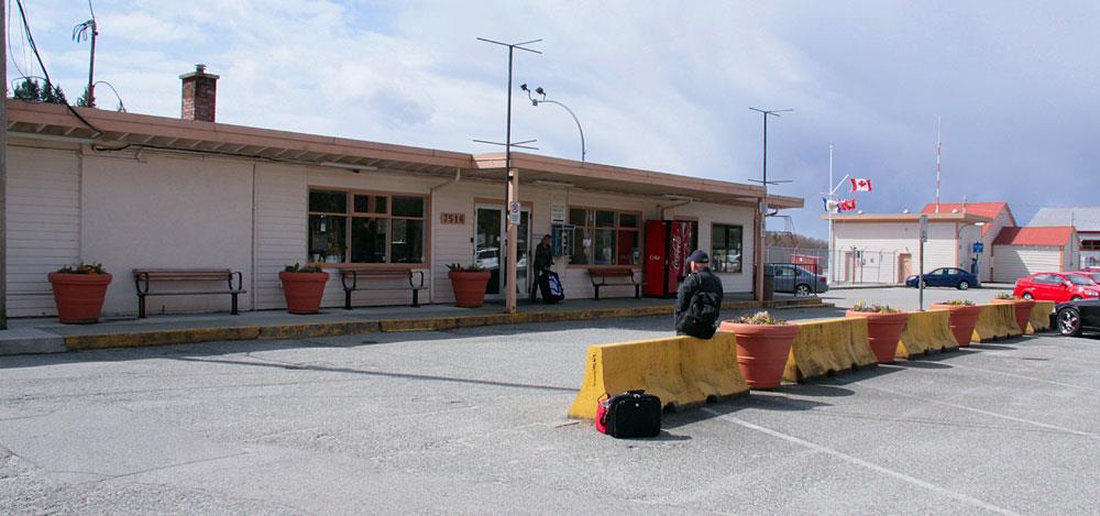
8 Powell River Strong Motion Sites
9 Structural Monitoring Provides response of structure to the ground shaking Damage detection Damage location this is complex Bonus ongoing structural health monitoring Response of structure to ambient vibration Confirmation of design hypotheses Rehabilitation planning Detection of impact, dislocation and deterioration
10 Early Warning Systems Japan is the leader in these systems - has an advanced system worked very well during last earthquake Turkey also has a small but excellent system Mexico, California have limited systems BC has a very limited system GMT The next step for many of us to expand and improve our systems BC EWS in development
11 Concept of BCSIMS Autonomous and remotely operated Parameters relevant to engineers and responders Structural sensors respond to EQ, wind, traffic, impacts... Results displayed online at the website either through the public or authorized access, and s reports (alerts) to subscribers Shake maps enable emergency managers, responders and inspectors to estimate damage, location and need Engineers use shake maps/values to compare with what structures designed for decide potential for damage For instrumented structure, estimate potential damage and location Facilitate attention to structural & utility problems to avoid escalation
12 The Team 1. BC Ministry of Transportation and Infrastructure 2. UBC Earthquake Engineering Research Facility (EERF), Department of Civil Engineering 3. Pacific Geoscience Centre of Geological Survey of Canada 4. Institut National de Recherche en Informatique et en Automatique (INRIA) of France 5. Structural Vibration Solutions A/S (SVS) of Denmark
13 BCSIMS - Why MoTI? MoTI Responsibility Aged bridges and rehabilitation challenges Post earthquake inspections Keeping the routes open Being prepared (planned retrofits, awareness) Field intelligence damage, severity? Prioritization Changing plans Risks/decisions Post Disaster Response & Recovery

14 2005 and Prior SM notice

15 SM notice

16 BCSIMS Home Page
17 Using BCSIMS - Earthquake Response Zoomable Shake Maps with Intensity Acceleration Velocity Displacement Structural status Historical event data
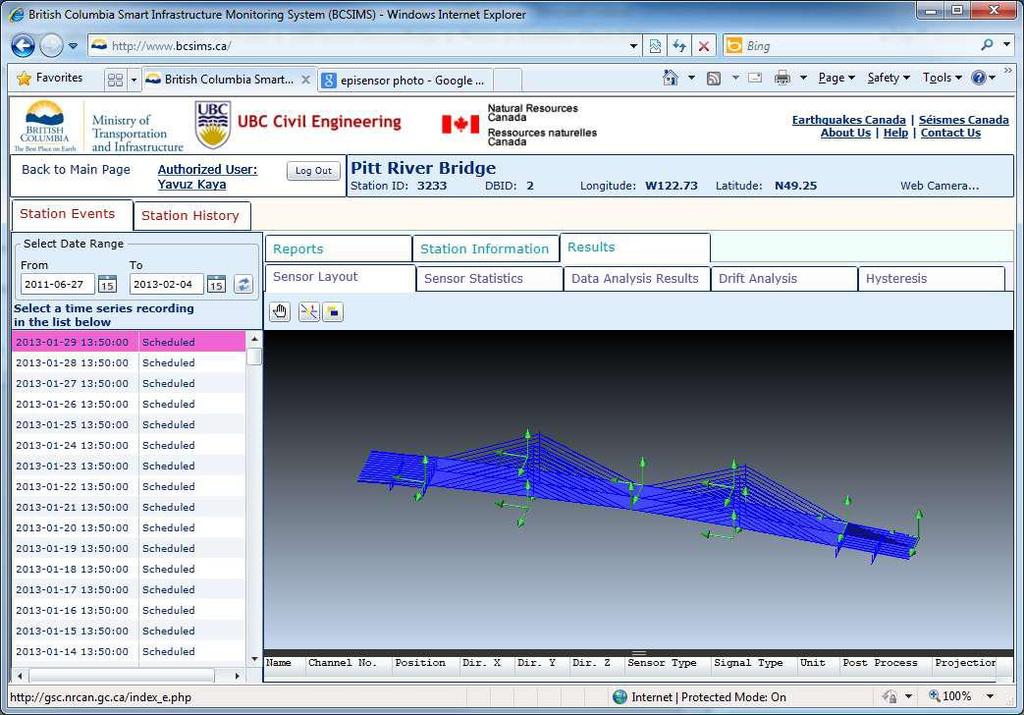
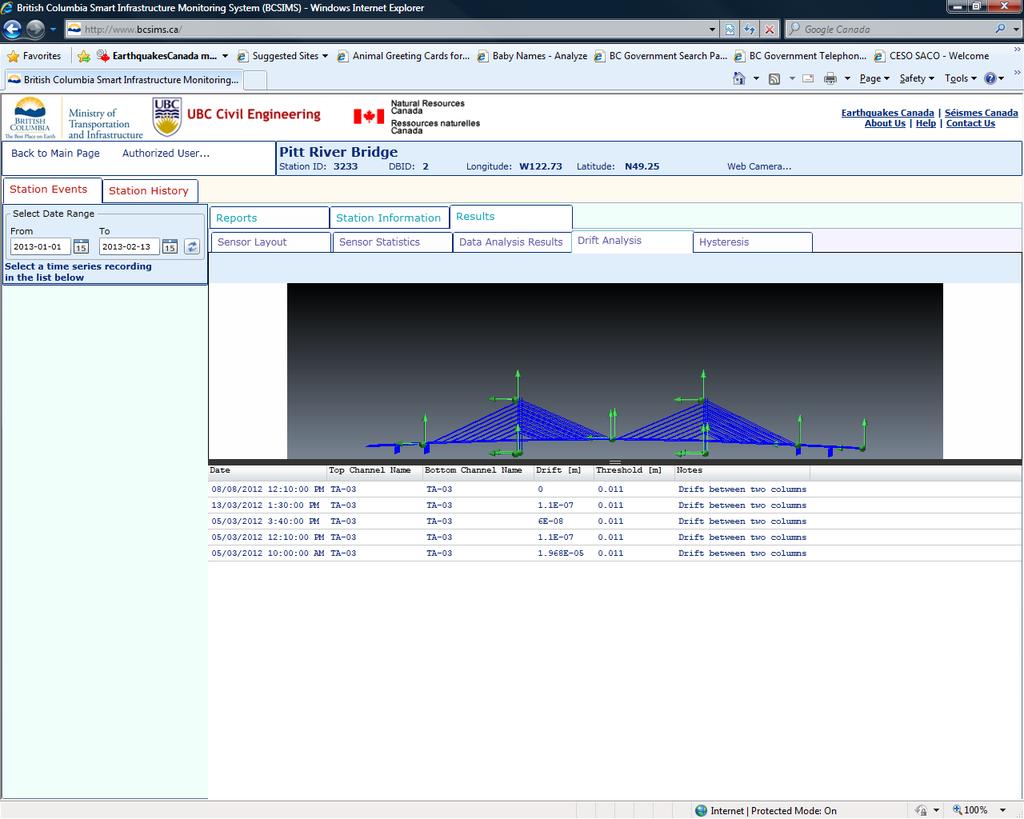
18 JMA Intensity map for 6.3 on Nootka Fault

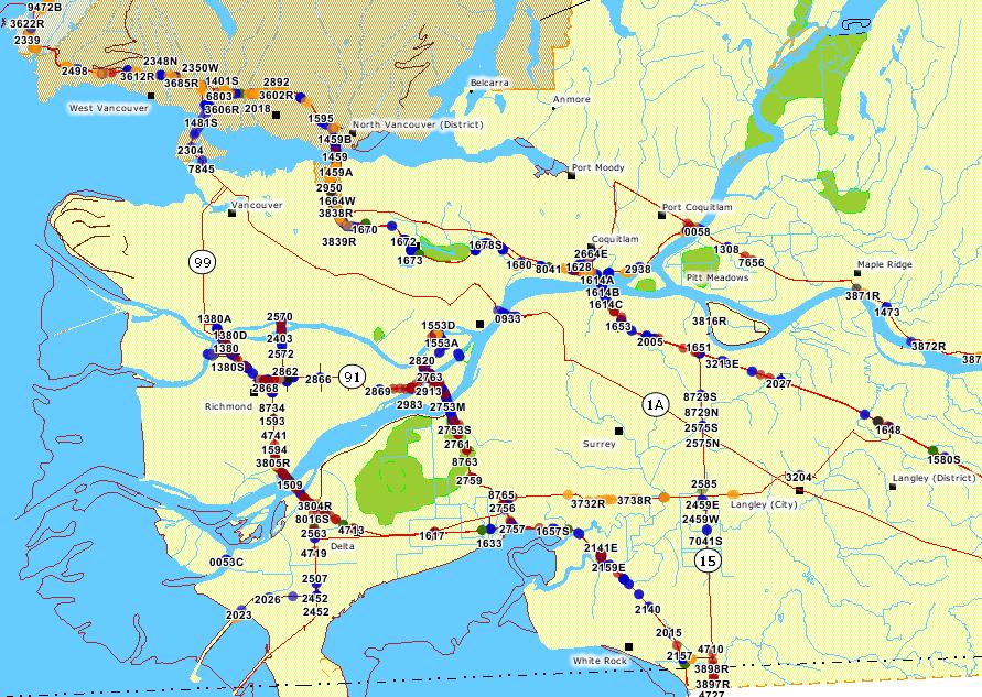
19 Instrument Intensity map for 6.3 on Nootka Fault
20 Using BCSIMS - Earthquake Response Real-time field intelligence Compare measured seismic Demand with predetermined Capacity Rapid plan adjustment Effective deployment of response resources Damage estimations global & local Earlier start to recovery efforts Ongoing monitoring aftershocks

21 Simulation zoomed shake map
22 System Alerts Notice that the shake maps do not show station dots (just the instrumented bridges) We can overlay the shake maps with relevant layers bridge inventory layer for us Disaster routes, other major routes - for inet Hospitals, first aid stations -? Water/sewer lines -?


23 Using BCSIMS To Come layers Bridge Engineering

24 2011 April 14 Rockslide Sea-to-Sky
25 Using BCSIMS: Structure Information Reports: Summary and comprehensive set of information in HTML format (can be received by or accessed through website) Information on monitoring system, photos, drawings, bridge information Public data and authorized data access Results: statistics for each measured channel, drift, modal analysis, damage detection 3D model with results
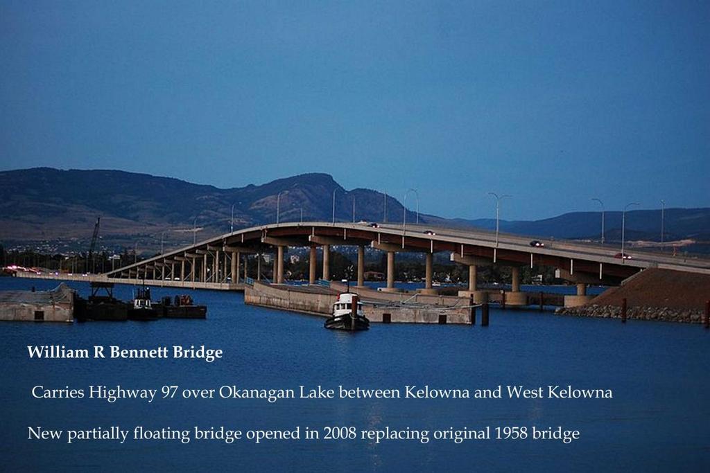
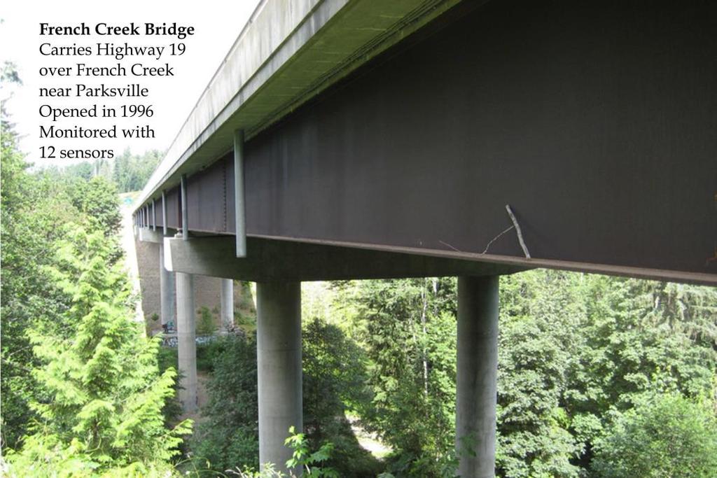
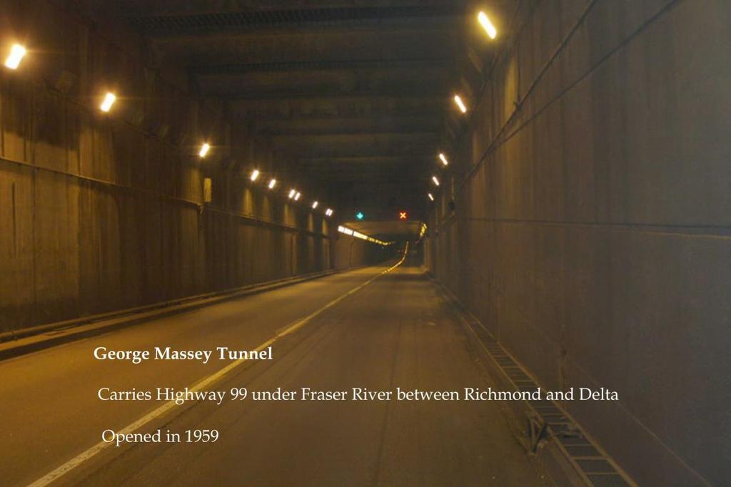
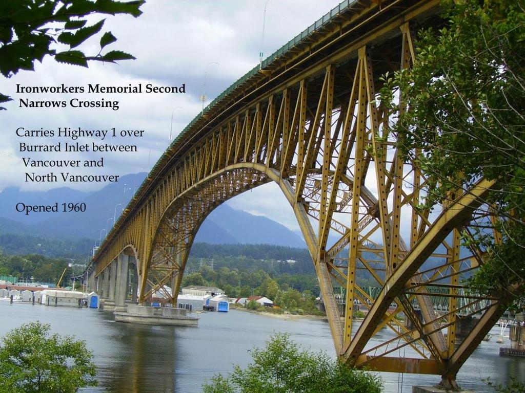
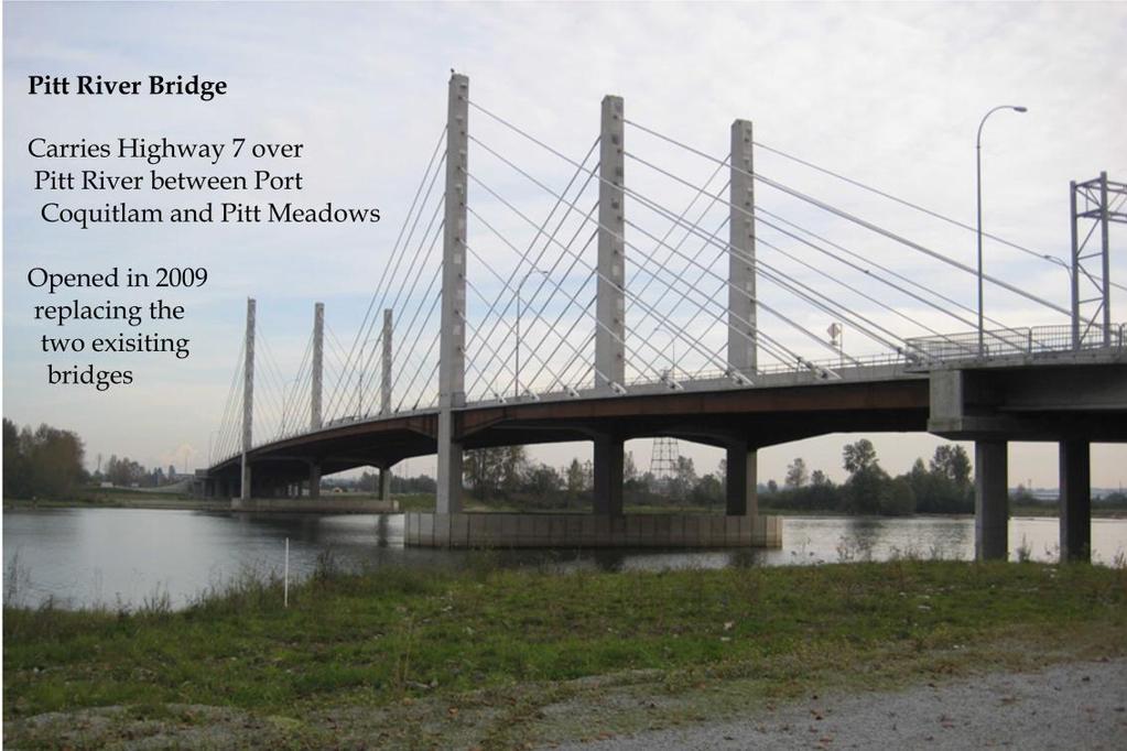
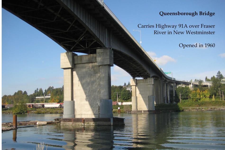
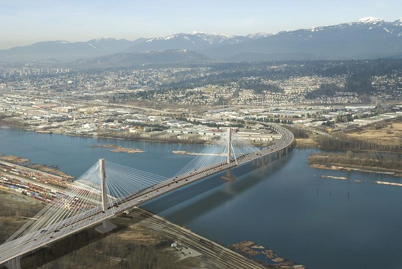
26 Instrumented Provincial Bridges Currently instrumented Queensborough - Port Mann French Creek - Fraser Heights Portage Creek - Kensington George Massey Tunnel - Gaglardi William R Bennett Bridge th St Pitt River Bridge - Second Narrows Bridge Engineering
27
28
29 Instrumented Provincial Bridges To Come New Hwy 17 overpass/sfpr Sunbury BNSF Tannery To Come Existing Powell R bridge 5 more being identified Bridge Engineering


30 Additional SHM to come City of Vancouver Cambie Burrard
31 Additional SHM to come Ministry of Education Undecided number of retrofitted schools Catholic Archdiocese of Vancouver 20 schools identified potential 60 total
32
33
34 In-process & Coming System Updates Major graphical interface overhaul Improved shake map algorithms Mapping for mobile devices Capability for messaging on the homepage Multiple user-selected data layers Simplified structure information pages
35 BC Early Warning System Network system MoTI/UBC developing/testing new instruments Small Low power usage Combined with SMN for economy Must detect and measure P-wave & PGA Inexpensive Ocean Networks developing system software
36 THANK YOU Bridge Engineering
British Columbia Smart Infrastructure Monitoring System
 579 ARTICLE British Columbia Smart Infrastructure Monitoring System Yavuz Kaya, Carlos Ventura, Sharlie Huffman, and Martin Turek Abstract: This paper describes the architecture of a comprehensive seismic
Seismic Activity and Crustal Deformation after the 2011 Off the Pacific Coast of Tohoku Earthquake
 J-RAPID Symposium March 6-7, 2013 Seismic Activity and Crustal Deformation after the 2011 Off the Pacific Coast of Tohoku Earthquake Y. Honkura Tokyo Institute of Technology Japan Science and Technology
Low-Latency Earthquake Displacement Fields for Tsunami Early Warning and Rapid Response Support
 Low-Latency Earthquake Displacement Fields for Tsunami Early Warning and Rapid Response Support Hans-Peter Plag, Geoffrey Blewitt Nevada Bureau of Mines and Geology and Seismological Laboratory University
Important Concepts. Earthquake hazards can be categorized as:
 Lecture 1 Page 1 Important Concepts Monday, August 17, 2009 1:05 PM Earthquake Engineering is a branch of Civil Engineering that requires expertise in geology, seismology, civil engineering and risk assessment.
Building earthquake early warning for the west coast. Ken Creager Professor of Earth and Space Sciences University of Washington
 Building earthquake early warning for the west coast Ken Creager Professor of Earth and Space Sciences University of Washington How Earthquake Early Warning works: P-waves S-waves 3-fold way of Earthquake
e-science on Earthquake Disaster Mitigation in Taiwan
 e-science on Earthquake Disaster Mitigation in Taiwan Eric Yen EGI User Forum, April 2011 ~50 earthquakes/day Taiwan Seismicity on Google Earth 0 15 30 70 100 150 km Eurasia Plate S01R Philippine Sea Plate
Design of Safety Monitoring and Early Warning System for Buried Pipeline Crossing Fault
 5th International Conference on Civil Engineering and Transportation (ICCET 2015) Design of Safety Monitoring and Early Warning System for Buried Pipeline Crossing Fault Wu Liu1,a, Wanggang Hou1,b *, Wentao
REAL-TIME ASSESSMENT OF EARTHQUAKE DISASTER IN YOKOHAMA BASED ON DENSE STRONG-MOTION NETWORK
 REAL-TIME ASSESSMENT OF EARTHQUAKE DISASTER IN YOKOHAMA BASED ON DENSE STRONG-MOTION NETWORK Saburoh MIDORIKAWA 1 And Susumu ABE 2 SUMMARY This paper describes a system for REal-time Assessment of earthquake
GROUND RESPONSE ANALYSIS FOR SEISMIC DESIGN IN FRASER RIVER DELTA, BRITISH COLUMBIA
 13 th World Conference on Earthquake Engineering Vancouver, B.C., Canada August 1-6, 2004 Paper No. 2104 GROUND RESPONSE ANALYSIS FOR SEISMIC DESIGN IN FRASER RIVER DELTA, BRITISH COLUMBIA Uthaya M. UTHAYAKUMAR
WMO Guide on Integrated Urban Weather, Environment and Climate Services for Cities (IUWECS) Hong Kong- an experience from a high-density city
 Hong Kong- an experience from a high-density city") WMO Guide on Integrated Urban Weather, Environment and Climate Services for Cities (IUWECS) Hong Kong- an experience from a high-density city Dr. Chao REN Associate Professor School of Architecture The
WMO Guide on Integrated Urban Weather, Environment and Climate Services for Cities (IUWECS) Hong Kong- an experience from a high-density city Dr. Chao REN Associate Professor School of Architecture The
Japan Seismic Hazard Information Station
 Japan Seismic Hazard Information Station (J-SHIS) Hiroyuki Fujiwara National Research Institute for Earth Science and Disaster Prevention (NIED) Background of the Project Headquarters for Earthquake Research
Copernicus Overview. Major Emergency Management Conference Athlone 2017
 Copernicus Overview Major Emergency Management Conference Athlone 2017 Copernicus is a European programme implemented by the European Commission. The services address six thematic areas: land, marine,
Current Landscape of Spatial Decision Support Systems (SDSS) and Software Applications for Earthquake Disaster Management in Turkey
 and Software Applications for Earthquake Disaster Management in Turkey") Presented at the FIG Congress 2018, May 6-11, 2018 in Istanbul, Turkey Current Landscape of Spatial Decision Support Systems (SDSS) and Software Applications for Earthquake Disaster Management in Turkey
Presented at the FIG Congress 2018, May 6-11, 2018 in Istanbul, Turkey Current Landscape of Spatial Decision Support Systems (SDSS) and Software Applications for Earthquake Disaster Management in Turkey
A RECONNAISANCE REPORT THE PISCO, PERU EARTHQUAKE OF AUGUST 15, 2007
 Pisco Earthquake, Peru, August 15, 2007 A RECONNAISANCE REPORT ON THE PISCO, PERU EARTHQUAKE OF AUGUST 15, 2007 Jörgen Johansson Tatiana Torres Paola Mayorca Edwin Leon 2007 Pisco, Peru Earthquake Reconnaissance
Earthquakes. Earthquake Magnitudes 10/1/2013. Environmental Geology Chapter 8 Earthquakes and Related Phenomena
 Environmental Geology Chapter 8 Earthquakes and Related Phenomena Fall 2013 Northridge 1994 Kobe 1995 Mexico City 1985 China 2008 Earthquakes Earthquake Magnitudes Earthquake Magnitudes Richter Magnitude
ShakeAlert Earthquake Early Warning
 ShakeAlert Earthquake Early Warning Doug Given USGS, Pasadena Earthquake Program, Early Warning Coordinator 10 seconds 50 seconds 90 seconds USGS Earthquake Hazard Responsibilities USGS has the lead federal
M 7.1 EARTHQUAKE 5KM ENE OF RABOSO, MEXICO EXACT LOCATION: N W DEPTH: 51.0KM SEPTEMBER 19, 1:14 LOCAL TIME
 M 7.1 EARTHQUAKE 5KM ENE OF RABOSO, MEXICO EXACT LOCATION: 18.584 N 98.399 W DEPTH: 51.0KM SEPTEMBER 19, 2017 @ 1:14 LOCAL TIME Photo: Eduardo Verdugo / AP Photo: Alfredo Estrella/ Agence France-Presse/
Cascadia megathrust earthquakes: reducing risk through science, engineering, and planning
 Cascadia megathrust earthquakes: reducing risk through science, engineering, and planning NSF Hazards SEES EAR-1331412 Urban Science and Engineering Workshop 21 July 2014 Everything to do with M9 Cascadia
Guidelines for Site-Specific Seismic Hazard Reports for Essential and Hazardous Facilities and Major and Special-Occupancy Structures in Oregon
 Guidelines for Site-Specific Seismic Hazard Reports for Essential and Hazardous Facilities and Major and Special-Occupancy Structures in Oregon By the Oregon Board of Geologist Examiners and the Oregon
Overview. Tools of the Trade. USGS Decision-Making Tools for Pre-Earthquake Mitigation and Post-Earthquake Response
 USGS Decision-Making Tools for Pre-Earthquake Mitigation and Post-Earthquake Response Tools of the Trade DAVID WALD United States Geological Survey NEHRP Workshop: Developing Earthquake Scenarios Sept
The Hellenic Seismological Network of Crete (HSNC): Monitoring results and the new strong motion network
: Monitoring results and the new strong motion network") The Hellenic Seismological Network of Crete (HSNC): Monitoring results and the new strong motion network Georgios Chatzopoulos 1, Ilias Papadopoulos 1 and Filippos Vallianatos 1 1 Technological Educational
The Hellenic Seismological Network of Crete (HSNC): Monitoring results and the new strong motion network Georgios Chatzopoulos 1, Ilias Papadopoulos 1 and Filippos Vallianatos 1 1 Technological Educational
Surviving the Big One: Understanding and Preparing for a Major Earthquake in Western Oregon
 Surviving the Big One: Understanding and Preparing for a Major Earthquake in Western Oregon May 21, 2013 City of Salem Salem Public Library Althea Rizzo, Geological Hazards Program Coordinator Oregon Emergency
SURVEY PORTRAY SAFEGUARD
 SURVEY GSI (Headquarters) and Science Museum of Map and Survey Kokudochiriin (GSI) Main Bldg. P Science Museum of Map and Survey Main gate P Kokudochiriin (GSI) PORTRAY Tokyo SAFEGUARD 1 2 3 4 3 4 5 6
(ﺕﺎـﻣﺯﻷﺍﻭ ﺙﺭﺍﻮـﻜﻟﺍ ﺓﺭﺍﺩﺇ ﰲ ﺔـﺜﻳﺪﳊﺍ ﺐـﻴﻟﺎﺳﻷﺍ)
") א א א א א א W (الا ساليب الحديثة في ا دارة الكوارث والا زمات) ١٤٣٥L٧L١٦ ١٢ W א א א E ٢٠١٤L٥L١٥ ١١F W (دور نظ م المعلومات الجغرافية في الا دارة الحديثة للكوارث) ا عداد د. باقر بن محمد منصور الرمضان א ٢٠١٤
א א א א א א W (الا ساليب الحديثة في ا دارة الكوارث والا زمات) ١٤٣٥L٧L١٦ ١٢ W א א א E ٢٠١٤L٥L١٥ ١١F W (دور نظ م المعلومات الجغرافية في الا دارة الحديثة للكوارث) ا عداد د. باقر بن محمد منصور الرمضان א ٢٠١٤
M-8.1 EARTHQUAKE 87KM SW OF PIJIJIAPAN, MEXICO EXACT LOCATION: N W DEPTH: 69.7KM SEPTEMBER 7, 11:49 PST
 M-8.1 EARTHQUAKE 87KM SW OF PIJIJIAPAN, MEXICO EXACT LOCATION: 15.068 N 93.715 W DEPTH: 69.7KM SEPTEMBER 7, 2017 @ 11:49 PST Photo: Luis Alberto Cruz / AP Photo: Carlos Jasso 1 THE 2017 CHIAPAS MEXICO
PROBABILISTIC SEISMIC HAZARD MAPS AT GROUND SURFACE IN JAPAN BASED ON SITE EFFECTS ESTIMATED FROM OBSERVED STRONG-MOTION RECORDS
 13 th World Conference on Earthquake Engineering Vancouver, B.C., Canada August 1-6, 2004 Paper No. 3488 PROBABILISTIC SEISMIC HAZARD MAPS AT GROUND SURFACE IN JAPAN BASED ON SITE EFFECTS ESTIMATED FROM
JMA Tsunami Warning Services. Tomoaki OZAKI Senior Coordinator for Tsunami Forecast Modeling Japan Meteorological Agency
 JMA Tsunami Warning Services Tomoaki OZAKI Senior Coordinator for Tsunami Forecast Modeling Japan Meteorological Agency Organization Chart of the Government of Japan Cabinet Office Diet Ministry of Internal
Jeopardy. Final Jeopardy $100 $100 $100 $100 $100 $200 $200 $200 $200 $200 $300 $300 $300 $300 $400 $400 $400 $500 $500 $500 $500 $500
 Jeopardy Earthquakes Volcanoes Tsunamis Wildfires Landslides/ Droughts $100 $100 $100 $100 $100 $200 $200 $200 $200 $200 $300 $300 $300 $300 $300 $400 $400 $400 $400 $400 $500 $500 $500 $500 $500 Final
Magnitude 7.9 SE of KODIAK, ALASKA
 A magnitude 7.9 earthquake occurred at 12:31 am local time 181 miles southeast of Kodiak at a depth of 25 km (15.5 miles). There are no immediate reports of damage or fatalities. Light shaking from this
Seismic Hazard Abatement Program
 Seismic Hazard Abatement Program Recommendations To take the first steps toward a seismic mitigation program for older existing buildings To improve our current regulatory system for implementation of
Haiti: Earthquake on January 12, 2010
 Geophysical Hazards and Plate Boundary Processes In Central America, Mexico and the Caribbean Haiti: Earthquake on January 12, 2010 Situation, achievements and perspective. Hotel La Condesa, Costa Rica
ShakeAlert Phase 1: West Coast Earthquake Early Warning. Doug Given, USGS EEW Coordinator Education Symposium, Dec. 4, 2018
 ShakeAlert Phase 1: West Coast Earthquake Early Warning Doug Given, USGS EEW Coordinator Education Symposium, Dec. 4, 2018 Population WA 7M OR 4M Annualized Earthquake Losses, $6.1B 61% in California,
Figure Locations of the CWB free-field strong motion stations, the epicenter, and the surface fault of the 1999 Chi-Chi, Taiwan earthquake.
 2.2 Strong Ground Motion 2.2.1 Strong Ground Motion Network The world densest digital strong ground motion network of Taiwan with the station mesh of 3 km in the urban areas (Shin et al., 2) monitored
OBSERVATION OF STRONG EARTHQUAKE MOTION BY NATIONAL INSTITUTE FOR LAND AND INFRASTRUCTURE MANAGEMENT
 Journal of Japan Association for Earthquake Engineering, Vol.4, No.3 (Special Issue), 2004 OBSERVATION OF STRONG EARTHQUAKE MOTION BY NATIONAL INSTITUTE FOR LAND AND INFRASTRUCTURE MANAGEMENT Hiroaki UEHARA
Prevention Tsunami wall 10m high (breached by the tsunami due to land level falling by 3m)
") Plate margin Plates Causes Sendai, Japan Convergent plate margin Pacific and Eurasian Plates Convergent plate margin Sima (Pacific plate) moves towards the sial (Eurasian plate) Sima (Pacific plate) is
Plate margin Plates Causes Sendai, Japan Convergent plate margin Pacific and Eurasian Plates Convergent plate margin Sima (Pacific plate) moves towards the sial (Eurasian plate) Sima (Pacific plate) is
 Title Preliminary report of the 2011 off Earthquake Author(s) Takewaki, Izuru Citation Journal of Zhejiang University SCIE 327-334 Issue Date 2011-05 URL http://hdl.handle.net/2433/159442 RightThe final
3D Seismic Hazard and Risk Maps for Earthquake Awareness of Citizens with Aids of GIS and Remote Sensing Technologies
 3D Seismic Hazard and Risk Maps for Earthquake Awareness of Citizens with Aids of GIS and Remote Sensing Technologies Saburoh Midorikawa Tokyo Institute of Technology In Japan, seismic hazard and risk
Real Time Monitoring System for Megathrust Earthquakes and Tsunamis - Cabled Network System and Buoy System in Japan -
 Real Time Monitoring System for Megathrust Earthquakes and Tsunamis - Cabled Network System and Buoy System in Japan - 1 Subduction zones around the world Haiti Italy Turkey Tohoku Sichuan Taiwan Sumatra
Dense Ocean floor Network System for Earthquakes and Tsunamis DONET
 Dense Ocean floor Network System for Earthquakes and Tsunamis DONET Yoshiyuki Kaneda Japan Agency for Marine-Earth Science and Technology (JAMSTEC) ION 1 Earthquakes in the Nankai Trough Tokai Nankai Hyuga
Rapid Earthquake Loss Assessment: Stochastic Modelling and an Example of Cyclic Fatigue Damage from Christchurch, New Zealand
 Rapid Earthquake Loss Assessment: Stochastic Modelling and an Example of Cyclic Fatigue Damage from Christchurch, New Zealand John B. Mander 1 and Geoffrey W. Rodgers 2, David Whittaker 3 1 University
Estimation of Seismic Shutoff of Intelligent Gas Meters in the Tokyo Metropolitan Area
 Paper: Estimation of Seismic Shutoff of Intelligent Gas Meters in the Tokyo Metropolitan Area Yoshihisa Maruyama Λ,FumioYamazaki Λ, Yoshihisa Yano ΛΛ, and Naoyuki Hosokawa ΛΛ Λ Department of Urban Environment
Earthquakes Chapter 19
 Earthquakes Chapter 19 Does not contain complete lecture notes. What is an earthquake An earthquake is the vibration of Earth produced by the rapid release of energy Energy released radiates in all directions
NPTEL Online - IIT Kanpur. Course Name Geotechnical Earthquake Engineering. Department IIT Kanpur
 NPTEL Online - IIT Kanpur Course Name Geotechnical Earthquake Engineering Department Instructor Civil Engineering Department IIT Kanpur Prof. N.R. Patra Module 1 INTRODUCTION TO GEOTECHNICAL ENGINEERING
ON THE CORRELATION OF GROUND MOTION INDICES TO DAMAGE OF STRUCTURE MODELS
 3 th World Conference on Earthquake Engineering Vancouver, B.C., Canada August -6, 24 Paper No. 74 ON THE CORRELATION OF GROUND MOTION INDICES TO DAMAGE OF STRUCTURE MODELS Gilbert MOLAS, Mohsen RAHNAMA
Training System and Information Network for Earthquake Disaster Mitigation. Taiki SAITO. Building Research Institute (BRI)
") 1 Training System and Information Network for Earthquake Disaster Mitigation Taiki SAITO Chief Research Engineer, International Institute of Seismology and Earthquake Engineering (IISEE), Building Research
1 Training System and Information Network for Earthquake Disaster Mitigation Taiki SAITO Chief Research Engineer, International Institute of Seismology and Earthquake Engineering (IISEE), Building Research
I. Locations of Earthquakes. Announcements. Earthquakes Ch. 5. video Northridge, California earthquake, lecture on Chapter 5 Earthquakes!
 51-100-21 Environmental Geology Summer 2006 Tuesday & Thursday 6-9:20 p.m. Dr. Beyer Earthquakes Ch. 5 I. Locations of Earthquakes II. Earthquake Processes III. Effects of Earthquakes IV. Earthquake Risk
How to communicate Cascadia Subduction Zone earthquake hazards
 How to communicate Cascadia Subduction Zone earthquake hazards Tom Brocher Research Geophysicist Earthquake Science Center U.S. Geological Survey Menlo Park, California Seattle Post-Intelligencer Lessons
Real time Monitoring System for Earthquakes and Tsunamis (DONET)
") Real time Monitoring System for Earthquakes and Tsunamis (DONET) NankaiTrough Yoshiyuki Kaneda Japan Agency for Marine-Earth Science and Technology (JAMSTEC) POGO@Seoul Presentation 1 Earthquakes in the
Real time Monitoring System for Earthquakes and Tsunamis (DONET) NankaiTrough Yoshiyuki Kaneda Japan Agency for Marine-Earth Science and Technology (JAMSTEC) POGO@Seoul Presentation 1 Earthquakes in the
Magnitude 7.2 OAXACA, MEXICO
 A magnitude 7.2 earthquake has occurred in Oaxaca, Mexico at a depth of 24.6 km (15 miles). It was felt as far away as Guatemala. There have been no reported deaths directly linked to the earthquake. Emergency
Characteristics and introduction of Earthquake in Asia-Pacific region
 Characteristics and introduction of Earthquake in Asia-Pacific region 1906 San Francisco 2011 Tohoku 1999 Chi-Chi 1985 Mexico City 2004 Sumatra Chung-Han Chan 詹忠翰 2011 Christchurch To understand the characteristics
Earthquakes in Canada
 Earthquakes in Canada Maurice Lamontagne, Ph.D., ing. Geological Survey of Canada Natural Resources Canada 1 What is an Earthquake? P S P S P PS 2 2 Movement on a fault plane causes vibrations The larger
Magnitude 7.0 N of ANCHORAGE, ALASKA
 A magnitude 7.0 earthquake occurred just before 8:30 am local time 8 miles north of Anchorage at a depth of 40.9 km (25.4 miles). There are reports of major infrastructure damage and damage to many homes
Three Fs of earthquakes: forces, faults, and friction. Slow accumulation and rapid release of elastic energy.
 Earthquake Machine Stick-slip: Elastic Rebound Theory Jerky motions on faults produce EQs Three Fs of earthquakes: forces, faults, and friction. Slow accumulation and rapid release of elastic energy. Three
Research infrastructures in FP7: Seismology and Geophysics
 Research infrastructures in FP7: Seismology and Geophysics Domenico Giardini, ETHZ Internation Workshop on Disaster Risk Reduction Bruxelles 29-30 October, 2009 EC FP7 2007-2013 Seven-year targeted program
RECIPE FOR PREDICTING STRONG GROUND MOTIONS FROM FUTURE LARGE INTRASLAB EARTHQUAKES
 RECIPE FOR PREDICTING STRONG GROUND MOTIONS FROM FUTURE LARGE INTRASLAB EARTHQUAKES T. Sasatani 1, S. Noguchi, T. Maeda 3, and N. Morikawa 4 1 Professor, Graduate School of Engineering, Hokkaido University,
Interpretive Map Series 24
 Oregon Department of Geology and Mineral Industries Interpretive Map Series 24 Geologic Hazards, and Hazard Maps, and Future Damage Estimates for Six Counties in the Mid/Southern Willamette Valley Including
Floods 2014 a wake up call to natural hazards
 Floods 2014 a wake up call to natural hazards Floods affected 119 municipalities (out of 165) 22% of total population affected by floods More than 30 municipalities sustained extensive damage 57 lives
Earthquakes. Building Earth s Surface, Part 2. Science 330 Summer What is an earthquake?
 Earthquakes Building Earth s Surface, Part 2 Science 330 Summer 2005 What is an earthquake? An earthquake is the vibration of Earth produced by the rapid release of energy Energy released radiates in all
THE 2011 TOHOKU EARTHQUAKE IN JAPAN. VSU Lyuben Karavelov, Sofia, Bulgaria. Key words: Tohoku earthquake, strong ground motion, damage
 THE 2011 TOHOKU EARTHQUAKE IN JAPAN Radan Ivanov 1 VSU Lyuben Karavelov, Sofia, Bulgaria Abstract: This earthquake which occurred on March 11, 2011, had a magnitude of 9.0, which places it as the fourth
THE RESPONSE SPECTRUM
 (NBCC 25) Gail M. The Canadian Society for Civil Engineering, Vancouver Section THE RESPONSE SPECTRUM Seismic Hazard Analysis to obtain Uniform Hazard Response Spectrum (NBCC 25) Gail M. Department of
THE STUDY ON 4S TECHNOLOGY IN THE COMMAND OF EARTHQUAKE DISASTER EMERGENCY 1
 THE STUDY ON 4S TECHNOLOGY IN THE COMMAND OF EARTHQUAKE DISASTER EMERGENCY 1 Zhou Wensheng 1, Huang Jianxi 2, Li Qiang 3, Liu Ze 3 1 Associate Professor, School of Architecture, Tsinghua University, Beijing.
Establishment and Operation of a Regional Tsunami Warning Centre
 Establishment and Operation of a Regional Tsunami Warning Centre Dr. Charles McCreery, Director NOAA Richard H. Hagemeyer Pacific Tsunami Warning Center Ewa Beach, Hawaii USA Why A Regional Tsunami Warning
Y. Shioi 1, Y. Hashizume 2 and H. Fukada 3
 Y. Shioi 1, Y. Hashizume 2 and H. Fukada 3 1 Emeritus Professor, Hachinohe Institute of Technology, Hachinohe, Japan 2 Chief Engineer, Izumo, Misawa, Aomori, Japan 3 Profesr, Geo-Technical Division, Fudo
Foreshocks to Major Earthquakes In Nevada. Craig M. depolo Nevada Bureau of Mines and Geology
 Foreshocks to Major Earthquakes In Nevada Craig M. depolo Nevada Bureau of Mines and Geology Review foreshocks, particularly the 2008 Mogul earthquake, foreshock statistics and implications, multiple earthquakes
Preparation for Future Earthquake and Tsunami Hazards: Lessons Learned from the 2004 Sumatra-Andaman Earthquake and the Asian Tsunami
 First International Conference of Aceh and Indian Ocean Studies Organized by Asia Research Institute, National University of Singapore & Rehabilitation and Construction Executing Agency for Aceh and Nias
The Earthquake of Padang, Sumatra of 30 September 2009 scientific information and update
 The Earthquake of Padang, Sumatra of 30 September 2009 scientific information and update 01-October-2009 Christophe Vigny Directeur de recherches at CNRS Laboratoire de Géologie Geoscience Dept. Of ENS,
METEOROLOGICAL WARNINGS STUDY GROUP (METWSG)
") METWSG/4-SN No. 6 12/3/12 METEOROLOGICAL WARNINGS STUDY GROUP (METWSG) FOURTH MEETING Montréal, 15 to 18 May 2012 Agenda Item 6: Wind shear, turbulence and tsunami warnings TSUNAMI INFORMATION (Presented
METWSG/4-SN No. 6 12/3/12 METEOROLOGICAL WARNINGS STUDY GROUP (METWSG) FOURTH MEETING Montréal, 15 to 18 May 2012 Agenda Item 6: Wind shear, turbulence and tsunami warnings TSUNAMI INFORMATION (Presented
EARTHQUAKE HAZARD ASSESSMENT IN KAZAKHSTAN
 EARTHQUAKE HAZARD ASSESSMENT IN KAZAKHSTAN Dr Ilaria Mosca 1 and Dr Natalya Silacheva 2 1 British Geological Survey, Edinburgh (UK) imosca@nerc.ac.uk 2 Institute of Seismology, Almaty (Kazakhstan) silacheva_nat@mail.ru
GeoNet Project Update: Strong Ground Motion and Structural Monitoring in New Zealand
 GeoNet Project Update: Strong Ground Motion and Structural Monitoring in New Zealand Ken Gledhill and the GeoNet Team GNS Science 2007 NZSEE Conference ABSTRACT: The GeoNet project, which is now in its
SEISMIC HAZARD ANALYSIS. Instructional Material Complementing FEMA 451, Design Examples Seismic Hazard Analysis 5a - 1
 SEISMIC HAZARD ANALYSIS Instructional Material Complementing FEMA 451, Design Examples Seismic Hazard Analysis 5a - 1 Seismic Hazard Analysis Deterministic procedures Probabilistic procedures USGS hazard
Ömer AYDAN. Ismail FEBRIN. Fumihiko IMAMURA KOGAMI (Tsunami Alert Community-NPO)
") ( ) JSCE-JAEE Team Andalas University Ömer AYDAN Ismail FEBRIN Fumihiko IMAMURA Abdul HAKAM Mas MERA KOGAMI (Tsunami Alert Community-NPO) Tomoji SUZUKI Patra Rina DEWI 10 4 10 9 LOCATION Padang Sikuai
( ) JSCE-JAEE Team Andalas University Ömer AYDAN Ismail FEBRIN Fumihiko IMAMURA Abdul HAKAM Mas MERA KOGAMI (Tsunami Alert Community-NPO) Tomoji SUZUKI Patra Rina DEWI 10 4 10 9 LOCATION Padang Sikuai
Comprehensive Emergency Management Plan
 Comprehensive Emergency Management Plan Section 6-Earthquake Annex Blank Intentionally 2 CEMP Annex 6 1 Earthquake Annex I. PURPOSE II. SITUATION The earthquake annex is a hazard-specific annex to be used
How GNSS CORS in Japan works for geodetic control and disaster mitigations
 ICG Working Group D Reference Frames, Timing and Applications How GNSS CORS in Japan works for geodetic control and disaster mitigations ICG11, Nov. 7-11, 2016, Sochi, Russia Hiromichi TSUJI Geodetic Observation
Interpretive Map Series 24
 Oregon Department of Geology and Mineral Industries Interpretive Map Series 24 Geologic Hazards, Earthquake and Landslide Hazard Maps, and Future Earthquake Damage Estimates for Six Counties in the Mid/Southern
Seismic Vulnerability Assessment of Wood-frame Buildings in Southwestern British Columbia
 Seismic Vulnerability Assessment of Wood-frame Buildings in Southwestern British Columbia K. Goda University of Bristol, United Kingdom G.M. Atkinson University of Western Ontario, Canada ABSTRACT: The
NEAR FIELD EXPERIMENTAL SEISMIC RESPONSE SPECTRUM ANALYSIS AND COMPARISON WITH ALGERIAN REGULATORY DESIGN SPECTRUM
 The th World Conference on Earthquake Engineering October -7, 8, Beijing, China NEAR FIELD EXPERIMENTAL SEISMIC RESPONSE SPECTRUM ANALYSIS AND COMPARISON WITH ALGERIAN REGULATORY DESIGN SPECTRUM N. Laouami
Lessons from the 2004 Sumatra earthquake and the Asian tsunami
 Lessons from the 2004 Sumatra earthquake and the Asian tsunami Kenji Satake National Institute of Advanced Industrial Science and Technology Outline 1. The largest earthquake in the last 40 years 2. Tsunami
The 2016, October 26, Central Italy Earthquake Origin Time 17:10:36 UTC, M L(ISNet) =5.3; M W(ISNet) =5.6
 =5.3; M W(ISNet) =5.6") The 2016, October 26, Central Italy Earthquake Origin Time 17:10:36 UTC, M L(ISNet) =5.3; M W(ISNet) =5.6 RISSC-Lab: Laboratorio di RIcerca in Sismologia Sperimentale e Computazionale The event as seen
The 2016, October 26, Central Italy Earthquake Origin Time 17:10:36 UTC, M L(ISNet) =5.3; M W(ISNet) =5.6 RISSC-Lab: Laboratorio di RIcerca in Sismologia Sperimentale e Computazionale The event as seen
NGIAs' roles in successful disaster response
 The Second UN-GGIM-AP Plenary Meeting NGIAs' roles in successful disaster response Japan Teheran Iran 28 October 2013 Shin-ichi SAKABE, Director of International Affairs Division Geospatial Information
EARTHQUAKES AND EARTHQUAKE-RESISTANT DESIGN OF STRUCTURES. Er. K. S. BHARGAV LECTURER Department of Civil Engineering, GGSGP CHEEKA
 EARTHQUAKES AND EARTHQUAKE-RESISTANT DESIGN OF STRUCTURES by Er. K. S. BHARGAV LECTURER Department of Civil Engineering, GGSGP CHEEKA SCOPE OF PRESENTATION EARTHQUAKE AND ITS CHARACTERIZATION EARTHQUAKE-RESISTANT
OC Public Works El Niño Storm Preparation 2015
 OC Public Works El Niño Storm Preparation 2015 December 8, 2015 Overview About OC Public Works Storm Preparation Pre-Storm During Storm Post-Storm Storm Preparation Canyon and Burn Areas County Department
CONSTRUCTION OF A DATA BASE SYSTEM FOR IRRIGATION DAMS
 CONSTRUCTION OF A DATA BASE SYSTEM FOR IRRIGATION DAMS TANI SHIGERU 1 SUMMARY The Hyogo-Ken Nambu Earthquake damaged many earthen structures. The Japanese Society of Civil Engineers stated that databases
Ground Motion Studies for Critical Sites in North-West Bangladesh
 Science & Technology Conference 2011 Vienna, June 8-10, 2011 Ground Motion Studies for Critical Sites in North-West Bangladesh Dr. Tahmeed M. Al Hussaini Professor of Civil Engineering, Bangladesh University
Damage Estimation of the Road Bridge Structure Using the Seismic Hazard map for BCM in Hokkaido, Japan
 Damage Estimation of the Road Bridge Structure Using the Seismic Hazard map for BCM in Hokkaido, Japan T. Sato & H. Nishi Civil Engineerring Research Institute for Cold Region, PWRI,Japan T. Ikeda & Y.
PRELIMINARY REPORT. July 21th 2017 Bodrum Offshore Earthquake (Muğla-Turkey) Mw=6.5.
 Mw=6.5.") PRELIMINARY REPORT July 21th 2017 Bodrum Offshore Earthquake (Muğla-Turkey) Mw=6.5 www.deprem.gov.tr www.afad.gov.tr REPUBLIC OF TUKEY MANAGEMENT PRESIDENCY An earthquake with magnitude Mw=6.5 occurred
PRELIMINARY REPORT July 21th 2017 Bodrum Offshore Earthquake (Muğla-Turkey) Mw=6.5 www.deprem.gov.tr www.afad.gov.tr REPUBLIC OF TUKEY MANAGEMENT PRESIDENCY An earthquake with magnitude Mw=6.5 occurred
Disaster and Science. Post-Tohoku research actions in France. March 6, 2013
 Disaster and Science Post-Tohoku research actions in France March 6, 2013 Question for the "Disaster and Science" session "HOW SCIENTIFIC COMMUNITY OF HIS/HER COUNTRY HAS REACTED AFTER MARCH 11, 2011 EARTHQUAKE"?
Geohazards and disaster risk reduction
 Geohazards and disaster risk reduction Susanne Sargeant 8 November 2017 Overview University and my PhD Seismology at BGS Learning other skills Working at the interface between science and resilience building
Earthquakes and Earthquake Hazards Earth - Chapter 11 Stan Hatfield Southwestern Illinois College
 Earthquakes and Earthquake Hazards Earth - Chapter 11 Stan Hatfield Southwestern Illinois College What Is an Earthquake? An earthquake is the vibration of Earth, produced by the rapid release of energy.
APPLICATIONS OF EARTHQUAKE HAZARD MAPS TO LAND-USE AND EMERGENCY PLANNING EXAMPLES FROM THE PORTLAND AREA
 APPLICATIONS OF EARTHQUAKE HAZARD MAPS TO LAND-USE AND EMERGENCY PLANNING EXAMPLES FROM THE PORTLAND AREA O. Gerald Uba Metro, Portland, Oregon OVERVIEW The extent to which we understand "below ground"
Challenges in providing effective flood forecasts and warnings
 Challenges in providing effective flood forecasts and warnings National Centre for Flood Research Inaugural Symposium Justin Robinson Bureau of Meteorology October 2018 Zero Lives Lost A key responsibility
SHAKE MAPS OF STRENGTH AND DISPLACEMENT DEMANDS FOR ROMANIAN VRANCEA EARTHQUAKES
 SHAKE MAPS OF STRENGTH AND DISPLACEMENT DEMANDS FOR ROMANIAN VRANCEA EARTHQUAKES D. Lungu 1 and I.-G. Craifaleanu 2 1 Professor, Dept. of Reinforced Concrete Structures, Technical University of Civil Engineering
Tectonic Processes and Hazards Enquiry Question 1: Why are some locations more at risk from tectonic hazards?
 Tectonic Processes and Hazards Enquiry Question 1: Why are some locations more at risk from tectonic hazards? Key words Basalt Andesite Rhyolite Benioff Zone Subduction zone Crustal fracturing Definition
Finding an Earthquake Epicenter Pearson Education, Inc.
 Finding an Earthquake Epicenter Measuring the Size of Earthquakes Two measurements that describe the size of an earthquake are: 1. Intensity a measure of the degree of earthquake shaking at a given locale
Overview of Early Warning Systems and the role of National Meteorological and Hydrological Services
 Overview of Early Warning Systems and the role of National Meteorological and Hydrological Services South Africa Second Experts Symposium on Multi-Hazard Early Warning Systems With focus on the Role of
Seismic Risk And Engineering Decisions (Developments In Geotechnical Engineering) READ ONLINE
 READ ONLINE") Seismic Risk And Engineering Decisions (Developments In Geotechnical Engineering) READ ONLINE If searching for a book Seismic Risk and Engineering Decisions (Developments in Geotechnical Engineering) in
Seismic Risk And Engineering Decisions (Developments In Geotechnical Engineering) READ ONLINE If searching for a book Seismic Risk and Engineering Decisions (Developments in Geotechnical Engineering) in
Workshop on SMART Cable Applications in Earthquake and Tsunami Science and Early Warning; Potsdam, Germany, 3 4 November 2016 Short Report
 Workshop on SMART Cable Applications in Earthquake and Tsunami Science and Early Warning; Potsdam, Germany, 3 4 November 2016 Short Report Frederik Tilmann + Bruce Howe, Rhett Butler, Stuart Weinstein
An overview of the applications for early warning and mapping of the flood events in New Brunswick
 Flood Recovery, Innovation and Reponse IV 239 An overview of the applications for early warning and mapping of the flood events in New Brunswick D. Mioc 1, E. McGillivray 2, F. Anton 1, M. Mezouaghi 2,
Modelling Strong Ground Motions for Subduction Events in the Wellington Region, New Zealand
 Proceedings of the Ninth Pacific Conference on Earthquake Engineering Building an Earthquake-Resilient Society 14-16 April, 2011, Auckland, New Zealand Modelling Strong Ground Motions for Subduction Events
Case Study of Japan: Crustal deformation monitoring with GNSS and InSAR
 Technical Seminar Reference Frame in Practice, Case Study of Japan: Crustal deformation monitoring with GNSS and InSAR Basara Miyahara miyahara-b96ip@milt.go.jp Geospatial Information Authority of Japan
A Study on the Risk Assessment of Emergency Supplies. Transportation Routes Considering Scenario Earthquakes
 ORIGINAL ARTICLE A Study on the Risk Assessment of Emergency Supplies Transportation s Considering Scenario Earthquakes Kazuaki Torisawa 1, Harumi Yashiro 2, Sei ichiro Fukushima 3*, Satoshi Kina 4 1 Kajima