Research infrastructures in FP7: Seismology and Geophysics
|
|
|
- Franklin Bryan
- 6 years ago
- Views:
Transcription
1 Research infrastructures in FP7: Seismology and Geophysics Domenico Giardini, ETHZ Internation Workshop on Disaster Risk Reduction Bruxelles October, 2009
2 EC FP Seven-year targeted program on four actions: Capacities: optimize existing RIs and create new RIs Cooperation: small and large integrated research projects People: Ideas: mobility of individual researchers and ITN investigator-driven research evaluated by ERC
3 EC FP Emphasis on large-scale integrated projects (IP, NE, I3) and free circulation of researchers (MC, RTN) Little room for FP5-type bottom-up research projects Clear selection process, with thresholds High administration overhead People SPICE RTN on seismic wave propagation, 14p Cooperation LESSLOSS IP on earthquake Risk, 46p SAFER small IP on seismic early warning, 18p TRANSFER small IP on tsunami early warning, 33p Capacities NERIES I3 seismic infrastructures, 25p
4 EC FP Capacities large programs (but smaller budgets than in FP6) only/mostly pre-defined titles very tough selection thresholds Infra-2008 I3 SERIES: Earthquake Engineering Infrastructures Infra RIs for Earthquake Hazard (I3 NERA) European Plate Observing Platform (ESFRI EPOS)
5 EC FP People individual researchers and ITN open calls oversubscribed, very competitive PEOPLE-ITN-2009 Earth s seismic sources and structure (QUEST) PEOPLE-ITN-2010 Several new proposals will be submitted
6 Cooperation EC FP overall program priorities defined for the 7-year period individual calls defined every year on the basis of national priorities and domain lobbying small (<3.5M) and large (<7M) projects ENV-2008 SHARE: Seismic hazard harmonization Seismic observatories: no proposal selected ENV-2009 SYNER-G: Systemic seismic vulnerability Seismic observatories: no proposal selected ENERGY-2009 GEISIR: induced seismicity in geothermal systems

7 Seismological infrastructures in/around Europe ~4 000 stations >180 networks
8 Network of European Research Infrastructures for Earthquake Seismology Goal: Integrated access to European seismological data Coordinator: Domenico Giardini (ORFEUS/ETHZ) Manager: Torild van Eck (ORFEUS/KNMI) Participants: ORFEUS, EMSC + 23 institutes; 13 European countries Duration: June 1, 2006 May 31, 2010 EC-contribution: 12.1 M Project web pages:

9 NA2: Networking Seismic Networks
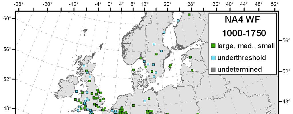
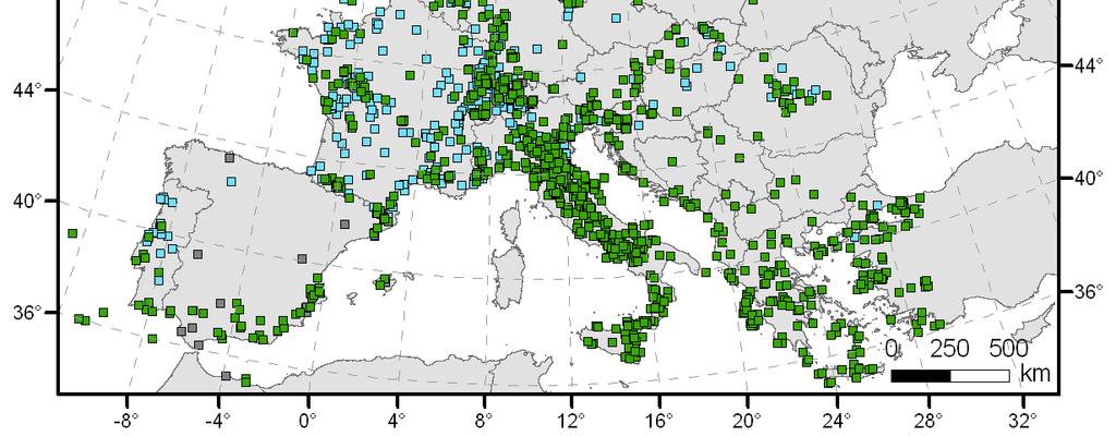
10 NA4: historical earthquake database


11 NA5: Networking accelerometric networks Total: 3,868 stations 1,402 free field 1,905 on struct 233 on dam 20 boreholes

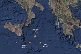
12 NA6: OBS deployments 30 June 2008 NERIES second Annual meeting

13 JRA1: European Reference model Shear-wave speed variation


14 JRA2: Real Time Hazard Tools NERIES JRA2 Earthquake SAFER WP2/5 NERIES JRA3 Long-term Hazard mapping Long-Term Forecasting Short-Term Forecasting Early Warning ShakeMaps & Rapid Loss Assessment Aftershock Hazard decades years days 0 seconds days years


15 JRA3: Shake & Loss-maps Loss estimation software: ELER
16 JRA5: Data Mining and Information Management Statistical analysis of catalogues XML standard for event parameters MAPSEIS Matlab applications Earth structure using ambient noise 16
17 Trans-national Access INGV SISMOS ZAMG Conrad Obs. NORSAR ETHZ CH-Net CEA-DASE
18 Inter-governmental organization, 26 European countries Goal: establishing a common roadmap for major EU RIs No own budget, funding must come from national sources Large infrastructures, range MEuro Roadmap WGs, including the RWG ENV Roadmap 2006: 35 RI Roadmap 2008: 8new RI, of which 2 ENV RI
19 EPOS: European Plate Observing System 30-year program for geophysical monitoring of the Euro- Med region, based on coordination of national efforts and cyber-infrastructures Focus on earthquakes, volcanoes, surface dynamics Core group of 8 countries, participation of 35 countries 500 Meuro budget, including the national infrastructures Dedicated call Infra for preparation phase
20 Lab-seismology--geodesy--geology
21 EPOS infrastructure concept Satellite observation infrastructure GMES, GEOSS,... Users, science, education, public User Interface Permanent Networks Temporary deployments In-situ Observatories European Plate Observing System Volcano Observatories Experimental Laboratories Data mining archiving Analytical Laboratories Computational Facilities (HPC, GRID) Ocean observation infrastructures, EMSO, ESONET,
22 WP1 P.P. MANAGEMENT WP5 STRATEGY WP6 Technical Implementation WP7 Architecture & implementation plan WP8 Stakeholder interactions & dissemination
23 TIME FRAMEWORK M M M M Dec 2008 EPOS enters in the ESFRI Roadmap M M M 48...
DANUBIUS. Advanced Studies. The Danube International Centre for. in the River Delta Sea systems: a Pan-European Research Infrastructure
 DANUBIUS The Danube International Centre for Advanced Studies in the River Delta Sea systems: a Pan-European Research Infrastructure Case study: Danube River Danube Delta Black Sea System In June 2011
New COST Action: Towards a European Network on Chemical Weather Forecasting and Information Systems
 New COST Action: Towards a European Network on Chemical Weather Forecasting and Information Systems Proposer: Mikhail Sofiev Finnish Meteorological Institute Historical background EUMETNET Workshop on
the IRIS Consortium Collaborative, Multi-user Facilities for Research and Education Briefing NSF Business Systems Review September 9, 2008
 the IRIS Consortium Collaborative, Multi-user Facilities for Research and Education Briefing NSF Business Systems Review September 9, 2008 A facilities program for collection and distribution of seismological
GEO Geohazards Community of Practice
 GEO Geohazards Community of Practice 1) Co-Chair of GHCP With input from: Stuart Marsh, GHCP Co-Chair Francesco Gaetani, GEO Secretariat and many GHCP contributors 1) Nevada Bureau of Mines and Geology
HARMONIZATION OF SEISMIC HAZARD MAPS FOR THE WESTERN BALKAN COUNTRIES : Overview of main BSHAP results
 Zagreb, Croatia Hotel Sheraton 12-13 May 2011 NATO SfP Project no. 983054 HARMONIZATION OF SEISMIC HAZARD MAPS FOR THE WESTERN BALKAN COUNTRIES : Overview of main BSHAP results Prof. Branislav Glavatović,
EC Funded Research on Tsunamis in the. Achievements and Perspectives
 EC Funded Research on Tsunamis in the FP6 and FP7 frameworks: Achievements and Perspectives Stefano Tinti University of Bologna stefano.tinti@unibo.it International Workshop on Disaster Risk Reduction
GMES EURORISK Geo-information services for natural and man-made risks management
 GMES EURORISK Geo-information services for natural and man-made risks management 8/11/2004 EURORISK A European scale approach for developing, delivering and operationally exploiting new information services
Training System and Information Network for Earthquake Disaster Mitigation. Taiki SAITO. Building Research Institute (BRI)
") 1 Training System and Information Network for Earthquake Disaster Mitigation Taiki SAITO Chief Research Engineer, International Institute of Seismology and Earthquake Engineering (IISEE), Building Research
1 Training System and Information Network for Earthquake Disaster Mitigation Taiki SAITO Chief Research Engineer, International Institute of Seismology and Earthquake Engineering (IISEE), Building Research
Global Monitoring for Environment and Security (GMES)
") Global Monitoring for Environment and Security (GMES) Satellite Earth Observation for the Emergency Services Dr Nick Veck Presentation to the G-STEP Launch Univ. of Leicester 19 th June 2009 Contents of
Global Monitoring for Environment and Security (GMES) Satellite Earth Observation for the Emergency Services Dr Nick Veck Presentation to the G-STEP Launch Univ. of Leicester 19 th June 2009 Contents of
Geodesy. orientation. shape. gravity field
 Geodesy noun Science of measuring the shape, orientation and gravity field of the Earth and how it changes over time. shape orientation gravity field Positioning has always been important Downstream applications
Earthquakes, Tsunamis and Nuclear Explosions: Open Data Exchange for Research and Monitoring in Seismology
 Earthquakes, Tsunamis and Nuclear Explosions: Open Data Exchange for Research and Monitoring in Seismology David Simpson IRIS Consortium Washington, DC Symposium on Data Sharing Plans for GEOSS and Benefits
The IISEE earthquake catalog, Catalog of Damaging Earthquakes in the World, IISEE-NET,, and BRI strong motion observation
 The IISEE earthquake catalog, Catalog of Damaging Earthquakes in the World, IISEE-NET,, and BRI strong motion observation Tatsuhiko Hara International Institute of Seismology and Earthquake Engineering,
EuroGEOSS for Drought - Linking the European Drought Observatory to global and local scales
 EuroGEOSS for Drought - Linking the European Drought Observatory to global and local scales Barbara Hofer, Stefan Niemeyer, EC-JRC INSPIRE Conference 2010 Cracow June 24, 2010 Drought Relevance Droughts
C o p e r n i c u s a n d W I G O S
 C o p e r n i c u s a n d W I G O S Jean-Noël Thépaut & Mark Dowell 24 October 2017 GEO XIV, Washington DC, 23-28 October 2017 T h e C o p e r n i c u s P r o g r a m m e Copernicus is the European Union
NATO SfP HARMONIZATION OF SEISMIC HAZARD MAPS FOR THE WESTERN BALKAN COUNTRIES (BSHAP)
") Information Day NATO Science for Peace and Security (SPS) Programme: Enhancing Partnership through Cooperation 4 February 2010, Istanbul/Turkey Suleyman Demirel Cultural Centre / Istanbul Technical University
Information Day NATO Science for Peace and Security (SPS) Programme: Enhancing Partnership through Cooperation 4 February 2010, Istanbul/Turkey Suleyman Demirel Cultural Centre / Istanbul Technical University
Wireless Networks in Geophysical Monitoring
 Workshop on New Frontiers in Internet of Things 7-18 March 2016 Trieste, Italy Wireless Networks in Geophysical Monitoring Hairo Villalobos Vulcanological and Seismological Observatory of Costa Rica, National
Open Data meets Big Data
 Open Data meets Big Data Max Craglia, Sven Schade, Anders Friis European Commission Joint Research Centre www.jrc.ec.europa.eu Serving society Stimulating innovation Supporting legislation JRC is Technical
The Safeland Project General Overview and Monitoring Technology Development
 Ber. Geol. B. A., 82, ISSN 1017 8880 Landslide Monitoring Technologies & Early Warning Systems The Safeland Project General Overview and Monitoring Technology Development The SafeLand Consortium a), N.
Establishment and Operation of a Regional Tsunami Warning Centre
 Establishment and Operation of a Regional Tsunami Warning Centre Dr. Charles McCreery, Director NOAA Richard H. Hagemeyer Pacific Tsunami Warning Center Ewa Beach, Hawaii USA Why A Regional Tsunami Warning
Sediment Disasters and Mass Movement (SD&M 2 ) NATIONAL DISASTER MANAGEMENT RESEARCH INSTITUTE
 NATIONAL DISASTER MANAGEMENT RESEARCH INSTITUTE") Sediment Disasters and Mass Movement (SD&M 2 ) Contents Outline of SD&M 2 Major outcomes Issues and conclusions Prologue Mass movement in Ulsan, Korea by Typhoon CHABA on Oct. 5. Outline of SD&M 2 Activities
Sediment Disasters and Mass Movement (SD&M 2 ) Contents Outline of SD&M 2 Major outcomes Issues and conclusions Prologue Mass movement in Ulsan, Korea by Typhoon CHABA on Oct. 5. Outline of SD&M 2 Activities
International Union of Geodesy and Geophysics. Resolutions
 International Union of Geodesy and Geophysics Resolutions ADOPTED BY THE COUNCIL AT THE XXVI GENERAL ASSEMBLY PRAGUE, CZECH REPUBLIC (22 JUNE 2 JULY 2015) 0 Page Resolution 1: Role of Ocean in Climate
GEO-VIII November Geohazard Supersites and Natural Laboratories Progress Report. Document 9
 GEO-VIII 16-17 November 2011 Geohazard Supersites and Natural Laboratories Progress Report Document 9 This document is submitted to GEO-VIII for information. Geohazard Supersites and Natural Laboratories
Geological information for Europe : Towards a pan-european Geological Data Infrastructure
 Geological information for Europe : Towards a pan-european Geological Data Infrastructure Integrating geoscientific information for EU competitiveness Co-funded by the European Union European societal
The BEYOND Center of Excellence for monitoring natural disasters from space
 The BEYOND Center of Excellence for monitoring natural disasters from space Ioannis Papoutsis National Observatory of Athens Institute for Astronomy, Astrophysics, Space Applications & Remote Sensing MOWE-IT
Plan4all (econtentplus project)
") Plan4all (econtentplus project) Karel CHARVAT 1, Tomáš MILDORF 2 1 Help service remote sensing, Ltd., Černoleská 1600, 256 01 Benešov u Prahy, Czech Republic charvat@bnhelp.cz 2 Department of Mathematics
Plan4all (econtentplus project) Karel CHARVAT 1, Tomáš MILDORF 2 1 Help service remote sensing, Ltd., Černoleská 1600, 256 01 Benešov u Prahy, Czech Republic charvat@bnhelp.cz 2 Department of Mathematics
Crisis Management and Natural Disasters Overview of JRC operational or pre-operational activities A. Annunziato, D. Al-Khudhairy
 Papagayo, Costarica 3-4 November 2009 Security Science and The Americas 1 Joint Research Centre (JRC) Crisis Management and Natural Disasters Overview of JRC operational or pre-operational activities A.
The Swedish National Geodata Strategy and the Geodata Project
 The Swedish National Geodata Strategy and the Geodata Project Ewa Rannestig, Head of NSDI Co-ordination Unit, Lantmäteriet, ewa.rannstig@lm.se Ulf Sandgren, Project Manager Geodata Project, Lantmäteriet,
Report of PCGIAP to the 18 th United Nations Regional Cartographic Conference for Asia and the Pacific (UNRCC-AP) for the period
 for the period") Permanent Committee on GIS Infrastructure for Asia and the Pacific (PCGIAP) Established in 1995 by a United Nations Resolution Report of PCGIAP to the 18 th United Nations Regional Cartographic Conference
Permanent Committee on GIS Infrastructure for Asia and the Pacific (PCGIAP) Established in 1995 by a United Nations Resolution Report of PCGIAP to the 18 th United Nations Regional Cartographic Conference
The new challenge of community-based environmental monitoring and information systems: the Citizens Obsrevatories Tito Scalo (PZ) 13 July 2016
 13 July 2016") The new challenge of community-based environmental monitoring and information systems: the Citizens Obsrevatories Tito Scalo (PZ) 13 July 2016 Involving citizens in environmental monitoring and awareness:
The new challenge of community-based environmental monitoring and information systems: the Citizens Obsrevatories Tito Scalo (PZ) 13 July 2016 Involving citizens in environmental monitoring and awareness:
Funded by Japan Government through UN ESCAP and BMKG
 METEOROLOGY & COAST RADIO SERVICES MINISTRY OF METEOROLOGY, ENERGY, INFORMATION,DISASTER MANAGEMENT, ENVIRONMENT, CLIMATE CHANGE AND COMMUNICATION KINGDOM OF TONGA P. O. Box 845, Domestic Terminal, Fua
Seismic Activity and Crustal Deformation after the 2011 Off the Pacific Coast of Tohoku Earthquake
 J-RAPID Symposium March 6-7, 2013 Seismic Activity and Crustal Deformation after the 2011 Off the Pacific Coast of Tohoku Earthquake Y. Honkura Tokyo Institute of Technology Japan Science and Technology
Low-Latency Earthquake Displacement Fields for Tsunami Early Warning and Rapid Response Support
 Low-Latency Earthquake Displacement Fields for Tsunami Early Warning and Rapid Response Support Hans-Peter Plag, Geoffrey Blewitt Nevada Bureau of Mines and Geology and Seismological Laboratory University
The Campanian Earthquake Early Warning Project
 The Campanian Earthquake Early Warning Project by Aldo Zollo and Claudio Satriano RISCC-Lab, Napoli, Italy www.rissclab.unina.it Earthquake Mitigation earthquake forecasting seismic risk enigineers/insurers
Gulf of Cadiz: Integrated observations from nearshore sources of tsunamis: Towards an early warning system NEAREST
 Gulf of Cadiz: Integrated observations from nearshore sources of tsunamis: Towards an early warning system NEAREST EC Project FP6, 2006-2009 (Contr. no. 037110) E. Gràcia (1), N. Zitellini (2), J.J. Dañobeitia
In situ Geothermal Lab Groß Schönebeck
 In situ Geothermal Lab Groß Schönebeck As a member of the Helmholtz Association, the GeoForschungsZentrum (GFZ) is the National Research Centre for Geosciences in Germany Foundation under public law Founded
Yev Kontar. Illinois State Geological Survey, University of Illinois at Urbana-Champaign
 Addressing Caribbean Geophysical Hazards through the Continuously Operating Caribbean GPS Observational Network (COCONet) and International Ocean Drilling Program (IODP) Yev Kontar Illinois State Geological
GEM Faulted Earth. A Global Active Fault and Fault Source Database
 GEM Faulted Earth A Global Active Fault and Fault Source Database Marco Pagani on behalf of GEM Faulted Earth Kelvin Berryman, Carlos Costa, Kerry Sieh Nicola Litchfield, Annemarie Christophersen THIS
European Plate Observing System: Ge8ng ready for EPOS construc<on
 EUROPEANPLATEOBSERVINGSYSTEM European Plate Observing System: Ge8ng ready for EPOS construc
PART A Project summary
 PART A Project summary A.1 Project identification Project title Project acronym Name of the lead partner organisation in English Specific objective Demonstrattion AF DAF Partner 1.1. Improving innovation
Asia-Pacific ground-base Optical Satellite Observation System APOSOS
 Asia-Pacific ground-base Optical Satellite Observation System APOSOS Center for Research and Application of Space Debris National Astronomical Observatories, CAS GUO Xiaozhong Oct 2011 Outline Space debris
Kentucky Seismic and Strong Motion Network - Including the Central United States Seismic Observatory (CUSSO)
") Kentucky Seismic and Strong Motion Network - Including the Central United States Seismic Observatory (CUSSO) Jonathan McIntyre Kentucky Geological Survey University of Kentucky Zhenming Wang Kentucky Geological
Kentucky Seismic and Strong Motion Network - Including the Central United States Seismic Observatory (CUSSO) Jonathan McIntyre Kentucky Geological Survey University of Kentucky Zhenming Wang Kentucky Geological
Publishable Summary. Summary Description of the project context and main objectives
 Publishable Summary Summary Description of the project context and main objectives Tsunamis are low frequency but high impact natural disasters. In 2004, the Boxing Day tsunami killed hundreds of thousands
CONFERENCE STATEMENT
 Final draft CONFERENCE STATEMENT We, the elected representatives of Canada, Denmark/Greenland, the European Parliament, Finland, Iceland, Norway, Russia, Sweden and the United States of America; In collaboration
JCOMM-CHy Coastal Inundation Forecasting Demonstration Project (CIFDP)
") WMO World Meteorological Organization Working together in weather, climate and water JCOMM-CHy Coastal Inundation Forecasting Demonstration Project (CIFDP) Coastal Flooding & Vulnerable Populations Coastal
WMO World Meteorological Organization Working together in weather, climate and water JCOMM-CHy Coastal Inundation Forecasting Demonstration Project (CIFDP) Coastal Flooding & Vulnerable Populations Coastal
What are the social, technical, environmental and economic benefits and opportunities of accessing and sharing geodetic data?
 What are the social, technical, environmental and economic benefits and opportunities of accessing and sharing geodetic data? Graeme Blick Group Manager Positioning and Resilience Land Information New
Meteorological instruments and observations methods: a key component of the Global Earth Observing System of Systems (GEOSS)
") GLOBAL OBSERVING SYSTEMS Instruments and Methods of Observation Programme Meteorological instruments and observations methods: a key component of the Global Earth Observing System of Systems (GEOSS) Dr.
GLOBAL OBSERVING SYSTEMS Instruments and Methods of Observation Programme Meteorological instruments and observations methods: a key component of the Global Earth Observing System of Systems (GEOSS) Dr.
Haiti: Earthquake on January 12, 2010
 Geophysical Hazards and Plate Boundary Processes In Central America, Mexico and the Caribbean Haiti: Earthquake on January 12, 2010 Situation, achievements and perspective. Hotel La Condesa, Costa Rica
Earth Observation and GEOSS in Horizon Copernicus for Raw Material Workshop 5 th September 2016
 Earth Observation and GEOSS in Horizon 2020 Copernicus for Raw Material Workshop 5 th September 2016 Gilles OLLIER Head of Sector -Earth observation Directorate Environment Unit I.4 Climate Actions and
Collaborative Systems for the Creation of Marine Services
 Collaborative Systems for the Creation of Marine Services INSPIRE 2016 Nuno Almeida Nuno Catarino Barcelona, 28 th September 2016 Elecnor Deimos is a trademark which encompasses Elecnor Group companies
BC Smart Infrastructure Monitoring System (BCSIMS)
") BC Smart Infrastructure Monitoring System (BCSIMS) 2013 UBC-Tongji-CSRN Symposium Sharlie Huffman, P.Eng. Sr. Seismic & Structural Health Engineer Bridge Engineering BCSIMS BC Seismicity Monitoring networks
BC Smart Infrastructure Monitoring System (BCSIMS) 2013 UBC-Tongji-CSRN Symposium Sharlie Huffman, P.Eng. Sr. Seismic & Structural Health Engineer Bridge Engineering BCSIMS BC Seismicity Monitoring networks
Satellite And Weather Information (SAWIDRA)/RARS
/RARS") Satellite And Weather Information for Disaster Resilience in Africa (SAWIDRA)/RARS Benjamin Lamptey, PhD ACMAD bllamptey@gmail.com EU funding and overall context 1. EUR 80 million Intra ACP Programme Building
Satellite And Weather Information for Disaster Resilience in Africa (SAWIDRA)/RARS Benjamin Lamptey, PhD ACMAD bllamptey@gmail.com EU funding and overall context 1. EUR 80 million Intra ACP Programme Building
EARTHQUAKE HAZARD ASSESSMENT IN KAZAKHSTAN
 EARTHQUAKE HAZARD ASSESSMENT IN KAZAKHSTAN Dr Ilaria Mosca 1 and Dr Natalya Silacheva 2 1 British Geological Survey, Edinburgh (UK) imosca@nerc.ac.uk 2 Institute of Seismology, Almaty (Kazakhstan) silacheva_nat@mail.ru
Current Landscape of Spatial Decision Support Systems (SDSS) and Software Applications for Earthquake Disaster Management in Turkey
 and Software Applications for Earthquake Disaster Management in Turkey") Presented at the FIG Congress 2018, May 6-11, 2018 in Istanbul, Turkey Current Landscape of Spatial Decision Support Systems (SDSS) and Software Applications for Earthquake Disaster Management in Turkey
Presented at the FIG Congress 2018, May 6-11, 2018 in Istanbul, Turkey Current Landscape of Spatial Decision Support Systems (SDSS) and Software Applications for Earthquake Disaster Management in Turkey
The Copernicus Climate Change (C3) service: State of play
 service: State of play") Enterprise and Industry The Copernicus Climate Change (C3) service: State of play B. Pinty (a) & J-N. Thépaut (b) (a) Copernicus G.2 unit (b) ECMWF CCI October2014 Legal frame & MS consultations Publica6on
Enterprise and Industry The Copernicus Climate Change (C3) service: State of play B. Pinty (a) & J-N. Thépaut (b) (a) Copernicus G.2 unit (b) ECMWF CCI October2014 Legal frame & MS consultations Publica6on
Explore African and Global early warning systems Climate Change effects on water cycle: Flood Risk. Revised website:
 JRC research activities on floods 1 Flood early warning (Europe) EFAS: European Flood Alert System IMPRINTS (DG RTD project): flash flood early warning EU-FLOOD-GIS ETN-R Explore African and Global early
IGOS Geohazards: toward an improved use of Earth Observations for Geohazards mitigation
 IGOS Geohazards: toward an improved use of Earth Observations for Geohazards mitigation Scientific and Technical Subcommittee session Vienna, 15th February 2007 Gonéri Le Cozannet IGOS Geohazards Bureau
Agency Vision and Decision- Maker Needs: A USGS Perspective
 Agency Vision and Decision- Maker Needs: A USGS Perspective Connecting Grassroots to Government for Disaster Management David Applegate USGS Associate Director for Natural Hazards September 13, 2012 U.S.
EU BON Building the European Biodiversity Observation Network
 EU BON Building the European Biodiversity Observation Network Christoph L. Häuser christoph.haeuser@mfn-berlin.de Museum für Naturkunde - Leibniz Institute for Research on Evolution and Biodiversity Berlin,
GEOMATICS AND DISASTER MANAGEMENT: Early Impact assessment in Haiti
 GEOMATICS AND DISASTER MANAGEMENT: Early Impact assessment in Haiti We will talk about... Post-disaster response: the main questions to be answered Post-disaster rapid mapping: the role of Geomatics The
The ENSEMBLES Project
 The ENSEMBLES Project Providing ensemble-based predictions of climate changes and their impacts by Dr. Chris Hewitt Abstract The main objective of the ENSEMBLES project is to provide probabilistic estimates
WEATHER AND CLIMATE EXTREMES MONITORING BASED ON SATELLITE OBSERVATION : INDONESIA PERSPECTIVE RIRIS ADRIYANTO
 WEATHER AND CLIMATE EXTREMES MONITORING BASED ON SATELLITE OBSERVATION : INDONESIA PERSPECTIVE RIRIS ADRIYANTO INDONESIA AGENCY FOR METEOROLOGY, CLIMATOLOGY AND GEOPHYSICS (BM KG) 1. INTRODUCTION - BMKG
National Earthquake Monitoring for Tsunami Early Warning. Burin Wechbunthung Sumalee Prachaub Seismological Bureau, Thai Meteorological Department
 National Earthquake Monitoring for Tsunami Early Warning Burin Wechbunthung Sumalee Prachaub Seismological Bureau, Thai Meteorological Department Seismic Sources Out line Historical Earthquake Damage from
A state of the art and user driven Copernicus service Physics and Biogeochemistry
 C M E M S P r e s e n t a n d F u t u r e R e q u i r e m e n t s f o r I n - S i t u a n d S a t e l l i t e O b s e r v a t i o n s Antonio REPPUCCI; Pierre Yves LE TRAON Mercator Ocean International
Space research. Horizon Work Programme. "Countdown to Horizon 2020 Space" Earth Observation topics. Brussels, 12 December 2013
 Space research Horizon 2020 - Work Programme "Countdown to Horizon 2020 Space" Earth Observation topics Brussels, 12 December 2013 richard.gilmore@ec.europa.eu Table of contents FP/Copernicus - general
Cascadia megathrust earthquakes: reducing risk through science, engineering, and planning
 Cascadia megathrust earthquakes: reducing risk through science, engineering, and planning NSF Hazards SEES EAR-1331412 Urban Science and Engineering Workshop 21 July 2014 Everything to do with M9 Cascadia
ShakeAlert Earthquake Early Warning
 ShakeAlert Earthquake Early Warning Doug Given USGS, Pasadena Earthquake Program, Early Warning Coordinator 10 seconds 50 seconds 90 seconds USGS Earthquake Hazard Responsibilities USGS has the lead federal
Cosmic Rays. Cooperation at the Space Pole. D. Sapundjiev, T. Verhulst, M. Dierckxsens, E. De Donder, N. Crosby, K. Stegen, and S.
 Cosmic Rays Cooperation at the Space Pole D. Sapundjiev, T. Verhulst, M. Dierckxsens, E. De Donder, N. Crosby, K. Stegen, and S. Stankov Excellence (STCE) Ringlaan 3, B-1180 Brussels, Belgium Stan Stankov
SAWIDRA Southern Africa
 SAWIDRA Southern Africa Presenter: Thembani Moitlhobogi Assistant Database and IT Expert SADC Climate Services Centre 13 th EUMETSAT Forum in Africa 24-28 September 2018, Abidjan, Cote d Ivoire Context
NUCLEAR EMERGENCY RESPONSE ACTIVITIES COORDINATION GROUP Original: ENGLISH EC-JRC ENSEMBLE APPROACH TO LONG RANGE ATMOSPHERIC DISPERSION
 WORLD METEOROLOGICAL ORGANIZATION COMMISSION FOR BASIC SYSTEMS CBS/CG-NERA/Doc. (number) (26.04.2006) OPAG on DPFS NUCLEAR EMERGENCY RESPONSE ACTIVITIES COORDINATION GROUP Original: ENGLISH VIENNA, AUSTRIA,
RETA 6422: Mainstreaming Environment for Poverty Reduction Category 2 Subproject
 RETA 6422: Mainstreaming Environment for Poverty Reduction Category 2 Subproject A. Basic Data 1. Subproject Title: Poverty-Environment Mapping to Support Decision Making 2. Country Director: Adrian Ruthenberg
Earthquake early warning for informationbased
 Earthquake early warning for informationbased societies Georgia Cua Swiss Seismological Service ETH Zürich, Switzerland EOST-IPGS Universite Louis Pasteur 22 November 2007 Outline What is early warning
World Meteorological Organization
 World Meteorological Organization Opportunities and Challenges for Development of Weather-based Insurance and Derivatives Markets in Developing Countries By Maryam Golnaraghi, Ph.D. Head of WMO Disaster
MeteoGroup RoadMaster. The world s leading winter road weather solution
 MeteoGroup RoadMaster The world s leading winter road weather solution Discover why RoadMaster is the world s leading winter road weather solution. Managing winter road maintenance means that you carry
Terrafirma Extension Tectonic Theme. 6 th Terrafirma Workshop ESA-ESRIN, December 1st, 2010
 Terrafirma Extension Tectonic Theme 6 th Terrafirma Workshop ESA-ESRIN, December 1st, 2010 Summary - Service Prospectus Presentation - The Terrafirma Extension Tectonic Theme (TFX-TT) - Greek Task Force
Characteristics and introduction of Earthquake in Asia-Pacific region
 Characteristics and introduction of Earthquake in Asia-Pacific region 1906 San Francisco 2011 Tohoku 1999 Chi-Chi 1985 Mexico City 2004 Sumatra Chung-Han Chan 詹忠翰 2011 Christchurch To understand the characteristics
Interpretive Map Series 24
 Oregon Department of Geology and Mineral Industries Interpretive Map Series 24 Geologic Hazards, and Hazard Maps, and Future Damage Estimates for Six Counties in the Mid/Southern Willamette Valley Including
Earthquakes. Earthquake Magnitudes 10/1/2013. Environmental Geology Chapter 8 Earthquakes and Related Phenomena
 Environmental Geology Chapter 8 Earthquakes and Related Phenomena Fall 2013 Northridge 1994 Kobe 1995 Mexico City 1985 China 2008 Earthquakes Earthquake Magnitudes Earthquake Magnitudes Richter Magnitude
Overview. Tools of the Trade. USGS Decision-Making Tools for Pre-Earthquake Mitigation and Post-Earthquake Response
 USGS Decision-Making Tools for Pre-Earthquake Mitigation and Post-Earthquake Response Tools of the Trade DAVID WALD United States Geological Survey NEHRP Workshop: Developing Earthquake Scenarios Sept
RVO s Mission Statement and some of the Key Result Areas stated below captures some of these alternative best practices.
 PART I. Introduction Rabaul Volcanological Observatory (RVO) is the national institution responsible for monitoring volcanoes Papua New Guinea. It comes under the Department of Mineral Policy and Geohazards
The Canadian Ceoscience Knowledge Network. - A Collaborative Effort for Unified Access to Ceoscience Data
 The Canadian Ceoscience Knowledge Network - A Collaborative Effort for Unified Access to Ceoscience Data The Canadian Geoscience Knowledge Network A Collaborative Effort for Unified Access to Geoscience
HISTORY OF HEAVY RAINFALL DISASTER INFORMATION IN JAPAN
 transmission, for a state-of-the-art review. In addition, issues expected to arise in the future are discussed. HISTORY OF HEAVY RAINFALL DISASTER INFORMATION IN JAPAN Progress of Rainfall Observation
Introduction. Thematic Mapping for Disaster Risk Assessment in Case of Earthquake FIG Working Week
 Thematic Mapping for Disaster Risk Assessment in Case of Earthquake Silvia MARINOVA, Temenoujka BANDROVA, Mihaela KOUTEVA-GUENTCHEVA, Stefan BONCHEV University of Architecture, Civil Engineering and Geodesy
Contribution of HPC to the mitigation of natural risks. B. Feignier. CEA-DAM Ile de France Département Analyse, Surveillance, Environnement
 Contribution of HPC to the mitigation of natural risks B. Feignier CEA-DAM Ile de France Département Analyse, Surveillance, Environnement Introduction Over the last 40 years, the increase in computational
Alaska Earthquake Center. By Natalia A. Ruppert Seismic Network Manager
 Alaska Earthquake Center By Natalia A. Ruppert Seismic Network Manager Geophysical Institute, University of Alaska Fairbanks Alaska Earthquake Center mission and historical perspective! Regional seismic
Seismic Recording Station AZ_PFO Summary Report
 Seismic Recording Station AZ_PFO Summary Report Thank you for hosting station AZ_PFO on your property. We hope that you find the enclosed report interesting. Your station is one of the 2000 USArray seismic
The UN-GGIM: Europe core data initiative to encourage Geographic information supporting Sustainable Development Goals Dominique Laurent, France
 INSPIRE conference Strasbourg 6 September 2017 The UN-GGIM: Europe core data initiative to encourage Geographic information supporting Sustainable Development Goals Dominique Laurent, France Introduction
Indian Ocean Tsunami Warning System: Example from the 12 th September 2007 Tsunami
 Indian Ocean Tsunami Warning System: Example from the 12 th September 2007 Tsunami Charitha Pattiaratchi 1 Professor of Coastal Oceanography, The University of Western Australia Email: chari.pattiaratchi@uwa.edu.au
TOPO-EUROPE an integrated solid earth approach to Continental Topography and Deep Earth Surface Processes in 4D
 roadmap Earth Science Europe Paris, 17-18 October 2012 TOPO-EUROPE an integrated solid earth approach to Continental Topography and Deep Earth Surface Processes in 4D Sierd Cloetingh, Sean Willett & TOPO-EUROPE
Application of a GIS for Earthquake Hazard Assessment and Risk Mitigation in Vietnam
 Application of a GIS for Earthquake Hazard Assessment and Risk Mitigation in Vietnam Nguyen Hong Phuong Earthquake Information and Tsunami Warning Centre, VAST OUTLINE Introduction Fault Source Model and
INSPIREd solutions for Air Quality problems Alexander Kotsev
 INSPIREd solutions for Air Quality problems Alexander Kotsev www.jrc.ec.europa.eu Serving society Stimulating innovation Supporting legislation The European data puzzle The European data puzzle 24 official
Geospatial application in Kiribati
 Geospatial application in Kiribati ICC-21 ST RESAP (9 TH TO 13 TH OCTOBER, 2017) BANGKOK, THAILAND Outline Kiribati Profile Natural disasters in Kiribati Achievements Challenges/Issues Ways forward 1 Kiribati
OGS (Udine, Italy)
") Antelope @ OGS (Udine, Italy) D. Pesaresi, P. L. Bragato, A. Saraò, A. Michelini, E. Priolo, P. Comelli, P. Di Bartolomeo, P. Bernardi, G. Costa dpesaresi@inogs.it Ist. Naz. di Oceanografia e di Geofisica
Antelope @ OGS (Udine, Italy) D. Pesaresi, P. L. Bragato, A. Saraò, A. Michelini, E. Priolo, P. Comelli, P. Di Bartolomeo, P. Bernardi, G. Costa dpesaresi@inogs.it Ist. Naz. di Oceanografia e di Geofisica
5. Principles. 1. Malaysia is not free from. Kuala Teriang, Langkawi
 5. Principles 1. Malaysia is not free from seismic-induced geohazards. However, the degree and magnitude of the geohazards are relatively small or minor because Malaysia is located in a stable tectonic
Disaster Prevention and Management in Asia: The Context of Human Security and Its Relevance to Infrastructure Planning and Management
 Disaster Prevention and Management in Asia: The Context of Human Security and Its Relevance to Infrastructure Planning and Management Rajib Shaw http://www.iedm.ges.kyoto-u.ac.jp/ Contents Background and
Geohazard Supersites and Natural Laboratories
 Geohazard Supersites and Natural Laboratories FRINGE 2011, Frascati, Italy, September 19, 2011 Wolfgang Lengert, ESA Falk Amelung, University of Miami, GEO task lead Craig Dobson, NASA, CEOS task lead
What is an Earthquake?
 Earthquakes What is an Earthquake? Earthquake - sometimes violent shaking of ground caused by movement of Earth s tectonic plates; creates seismic waves Often followed by smaller earthquakes (aftershocks);
INCA-CE: The Challenge of Severe Weather Warnings. Yong Wang, ZAMG
 INCA-CE: The Challenge of Severe Weather Warnings Yong Wang, ZAMG Severe Weather and Impact The need of civil society and economy Save Life! Save Cost! Reduce Risks and impacts! The Challenge of Severe
Introduction to future synergy options
 Deep Ocean Cabled Observatories Amsterdam, 24-25 May 2012 Introduction to future synergy options Uli Katz ECAP, Univ. Erlangen 25.05.2012 The next 20 minutes Synergy opportunities Mediterranean nodes in
SCIENCE OF TSUNAMI HAZARDS
 SCIENCE OF TSUNAMI HAZARDS ISSN 8755-6839 Journal of Tsunami Society International Volume 32 Number 1 2013 THE FRENCH TSUNAMI WARNING CENTER FOR THE MEDITERRANEAN AND NORTHEAST ATLANTIC: CENALT P. Roudil,
ESRI educational site license in Bahir Dar University. Tegegn Molla Abebe Mengaw Geospatial Data and Technology Center, BDU
 ESRI educational site license in Bahir Dar University Tegegn Molla Abebe Mengaw Geospatial Data and Technology Center, BDU September, 2016 Mission, Vision Purpose and Values of the GDTC Mission of GDTC