Dense Ocean floor Network System for Earthquakes and Tsunamis DONET
|
|
|
- June McKinney
- 5 years ago
- Views:
Transcription
1 Dense Ocean floor Network System for Earthquakes and Tsunamis DONET Yoshiyuki Kaneda Japan Agency for Marine-Earth Science and Technology (JAMSTEC) ION 1

2 Earthquakes in the Nankai Trough Tokai Nankai Hyuga nada 5-6cm/y Seismogenic Zone Tonankai 2-3cm/y 4-5cm/y Philippine Sea Plate DONET target area 2 M8+ class earthquakes every years. 2
3 The historical EQs. around the Nankai trough 1707 CD(TONANKAI) + E(TOKAI) + AB(NANKAI) 1854 CD(TONANKAI) + E(TOKAI) 32hours AB(NANKAI) 1944 CD(TONANKAI) 2years AB(NANKAI) 1946 M8 class EQs. are occurring with a interval of years 3


4 Earthquake Slip vs. Crustal Structures Subducting Oceanic Ridges Subducting Seamount Splay Fault High density, High velocity Domed Body Baba and Cummins (2005) Rupture Zone of Oceanic Crust 4

5 Concept of DONET Number of Science Node : 5 Node Number of User Interface : 8 port / Node Power Distribution : 30 W / Port Data Transmission : 50 Mbit / s / Port Precise Timing Control : < 1μsec 5
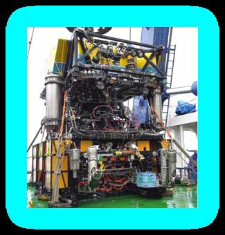
6 Concept of DONET Redundancy: Equipping redundant configuration on backbone cable and node Expandability: Branching unit enables wide-spread distribution of observation points. Node plays the role of hub that connects underwater instruments to the backbone cable system. Replaceable function: Replacing observation unit at the seafloor by using underwater removable connector Maintainability: Operation on the seafloor by using Remotely Operated Vehicle (ROV) 6


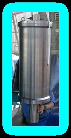
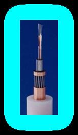

7 Landing Station Node Branching Unit Backbone Cable Ground Motion Sensing System Pressure Sensing System and Peripherals Extension Cable Remotely operated vehicle 7


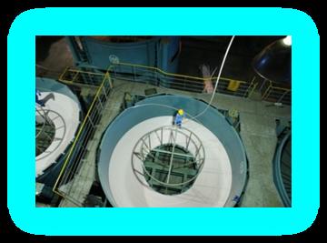
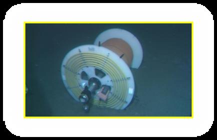
8 Installation of Science Node Japanese research ROV Hyper Dolphin Installed Termination Equipment N, E,Depth:2009m Construction of Installation hole for seismometer Installation hole Installation of sensors N, E Installed Science Node(A010) N, E,Depth:2009m

9 Installation of DONET(2010 Oct.) 9


10 2010/11/29 15:52 South of WAKAYAMA(M=4.1) OWASE- City Strong motion accelerometer A2 A4 A3 E17 Location:33.9N 135.4E Depth about 60km M = 4.1 (JMA) Pressure gauge Broadband seismometer T-phase? 10


11 2010/11/30 12:25(JST) Off OGASAWARA Islands (M=6.9) OWASE- City A2 A4 A3 E17 Strong motion accelerometer Location:28.4N 139.7E Depth about 480km M = 6.9 (JMA) Pressure gauge Broadband seismometer 11

12 Recorded data by DONET 17:14(GMT) May 27th 13.7S 166.6E 36km M7.4 Broadband seismometer Horizontal motion 1 Broadband seismometer Horizontal motion 2 Broadband seismometer Vertical motion 17:20:00 GMT 3,500sec

13 Example of recorded data 2010/8/13 21:19 (GMT) Mariana 12.5N 141.5E M6.9 Broadband seismometer DONET Strong motion acceler ometer Wave Pressure gauge Data of TUNAMI sec Pressure gauge 13 13
 in Singapore. Felt at Bangkok, Thailand. (USGS) Owase -city A2 DONET Broadband seismometer HHX (KMA02 low pass at 20 s) Location:3.5S, 100.1E Depth:20.")
14 2010/10/25 14:42(UTC) Sumatra (Mw=7.7) At least 340 people killed and 330 missing from the earthquake and tsunami with maximum height of 7meters. Felt (III) at Bukittinggi and Padang, Sumatra. Also felt at Bengkulu. Felt (II) in Singapore. Felt at Bangkok, Thailand. (USGS) Owase -city A2 DONET Broadband seismometer HHX (KMA02 low pass at 20 s) Location:3.5S, 100.1E Depth:20.6 km (USGS) HHY HHZ P S Rayleigh 0 5min 14

15 DONET 2 Concept A similar seafloor network system (DONET2) is needed for region off Kii Peninsula and Shikoku to decrease disasters caused by the subduction zone earthquakes in the Nankai Trough. Achievement of early detection of earthquake and tsunami in a wider area Advancement of earthquake occurrence simulation Development of Most Advanced and Leading Technologies DONET2 15
 Cable length1000km + DONET type NODE over 10 (100 ocean floor sites) DONET1 DONET2")
16 DONET2 High Voltage System After DONET 1 completion, move on to DONET2 with High Voltage System, then observational area expand to 2 Middle voltage system 3000V High voltage system 10KV Cable length 300km + DONET type NODE 5 (40 ocean floor sites) Cable length1000km + DONET type NODE over 10 (100 ocean floor sites) DONET1 DONET2 16


17 Integration of scientific projects Evaluate of Seismic Linkage around the Nankai trough Ocean floor network system Seismogenic zone drilling Simulation Precise survey DONET CHIKYU Super Computer R/V KAIREI Advanced of Seismic Linkage Model Contribute to the disaster prevention and mitigation of Earthquakes and Tsunamis 17
Real time Monitoring System for Earthquakes and Tsunamis (DONET)
") Real time Monitoring System for Earthquakes and Tsunamis (DONET) NankaiTrough Yoshiyuki Kaneda Japan Agency for Marine-Earth Science and Technology (JAMSTEC) POGO@Seoul Presentation 1 Earthquakes in the
Real time Monitoring System for Earthquakes and Tsunamis (DONET) NankaiTrough Yoshiyuki Kaneda Japan Agency for Marine-Earth Science and Technology (JAMSTEC) POGO@Seoul Presentation 1 Earthquakes in the
Real Time Monitoring System for Megathrust Earthquakes and Tsunamis - Cabled Network System and Buoy System in Japan -
 Real Time Monitoring System for Megathrust Earthquakes and Tsunamis - Cabled Network System and Buoy System in Japan - 1 Subduction zones around the world Haiti Italy Turkey Tohoku Sichuan Taiwan Sumatra
Japan Agency for Marine-Earth Science and Technology (JAMSTEC), 2-15 Natsushima-cho, Yokosuka JAPAN
, 2-15 Natsushima-cho, Yokosuka JAPAN") Dense Ocean floor Network System for Mega Thrust Earthquakes & Tsunamis(DONET) -Towards Understanding Mega Thrust Earthquakes, the Geohazard & Disaster Mitigation- Yoshiyuki KANEDA, Katsuyoshi KAWAGUCHI,
Dense Ocean floor Network System for Mega Thrust Earthquakes & Tsunamis(DONET) -Towards Understanding Mega Thrust Earthquakes, the Geohazard & Disaster Mitigation- Yoshiyuki KANEDA, Katsuyoshi KAWAGUCHI,
Submarine Cabled Real-time Seafloor Observatory and Subsea Engineering ROV for Observatory Construction
 Submarine Cabled Real-time Seafloor Observatory and Subsea Engineering ROV for Observatory Construction Katsuyoshi KAWAGUCHI, Sho Kaneko (Japan Agency for Marine-earth Science and Technology), Takato Nishida
NT10-09 Cruise Report KUMANO-NADA DONET Node Installation & Observatory Construction
 NT10-09 Cruise Report KUMANO-NADA DONET Node Installation & Observatory Construction June 2010 Table of Contents 1. Overview 2. Schedule 3. Dive Summary 4. Concluding Remarks 1. Overview DONET is a program
Seismic Activity and Crustal Deformation after the 2011 Off the Pacific Coast of Tohoku Earthquake
 J-RAPID Symposium March 6-7, 2013 Seismic Activity and Crustal Deformation after the 2011 Off the Pacific Coast of Tohoku Earthquake Y. Honkura Tokyo Institute of Technology Japan Science and Technology
JAMSTEC Marine Geophysical Projects for Researches on Subduction Cycles and Deformation
 JAMSTEC Marine Geophysical Projects for Researches on Subduction Cycles and Deformation Shuichi Kodaira Research Center for Earthquake and Tsunami JAMSTEC JAMSTEC Marine Geophysical Projects Motivation:
Cruise report of KY11-06 Leg1
 Cruise report of KY11-06 Leg1 Cruise : KY11-06 /Leg1 / R/V Kaiyo Research subject: Construction of Seafloor observation Network for Earthquakes and Tsunamis Research Proposal by: Yoshiyuki KANEDA/JAMSTEC
Crustal deformation by the Southeast-off Kii Peninsula Earthquake
 Crustal deformation by the Southeast-off Kii Peninsula Earthquake 51 Crustal deformation by the Southeast-off Kii Peninsula Earthquake Tetsuro IMAKIIRE, Shinzaburo OZAWA, Hiroshi YARAI, Takuya NISHIMURA
Source modeling of hypothetical Tokai-Tonankai-Nankai, Japan, earthquake and strong ground motion simulation using the empirical Green s functions
 Source modeling of hypothetical Tokai-Tonankai-Nankai, Japan, earthquake and strong ground motion simulation using the empirical Green s functions Y. Ishii & K. Dan Ohsaki Research Institute, Inc., Tokyo
Depth-dependent slip regime on the plate interface revealed from slow earthquake activities in the Nankai subduction zone
 2010/10/11-14 Earthscope Workshop Depth-dependent slip regime on the plate interface revealed from slow earthquake activities in the Nankai subduction zone Kazushige Obara, ERI, Univ. Tokyo Recurrence
Slip distributions of the 1944 Tonankai and 1946 Nankai earthquakes including the horizontal movement effect on tsunami generation
 Slip distributions of the 1944 Tonankai and 1946 Nankai earthquakes including the horizontal movement effect on tsunami generation Toshitaka Baba Research Program for Plate Dynamics, Institute for Frontier
A Technical Report on the Advanced Real-time Earth Monitoring Network in the Area (ARENA) Chapter 1: Preface. ver1.0. Contents
 Chapter 1: Preface. ver1.0. Contents") A Technical Report on the Advanced Real-time Earth Monitoring Network in the Area (ARENA) Chapter 1: Preface ver1.0 Contents 1.1Introduction 1.2Present state of scientific submarine cables in Japan 1.3Achievements
A Technical Report on the Advanced Real-time Earth Monitoring Network in the Area (ARENA) Chapter 1: Preface ver1.0 Contents 1.1Introduction 1.2Present state of scientific submarine cables in Japan 1.3Achievements
Electrical Conductivity Structures around Seismically Locked Regions
 Electrical Conductivity Structures around Seismically Locked Regions Tada-nori Goto Program for Deep Sea Research, IFREE, Japan Agency for Marine-Earth Science and Technology 1. Introduction Existence
New Seismic Activity Model of Large Earthquakes along Nankai Trough for Probabilistic Seismic Hazard Maps
 New Seismic Activity Model of Large Earthquakes along Nankai Trough for Probabilistic Seismic Hazard Maps Toshihiko Okumura (Shimizu Corp.) Hiroyuki Fujiwara (NIED) Plate Tectonics around Japan Pacific
Japan Agency for Marine-Earth Science and Technology (JAMSTEC), 2-15 Natsushima-cho, Yokosuka, Kanagawa, , JAPAN
, 2-15 Natsushima-cho, Yokosuka, Kanagawa, , JAPAN") LARGE EARTHQUAKE AND ASSOCIATED PHENOMENA OBSERVED WITH SEAFLOOR CABLED OBSERVATORY NEAR EPICENTER - AN IMPLICATION FOR POSSIBLE ADDITIONAL MEASUREMENT WITH TELECOMMUNICATION NETWORKS FOR IDENTIFICATION
LARGE EARTHQUAKE AND ASSOCIATED PHENOMENA OBSERVED WITH SEAFLOOR CABLED OBSERVATORY NEAR EPICENTER - AN IMPLICATION FOR POSSIBLE ADDITIONAL MEASUREMENT WITH TELECOMMUNICATION NETWORKS FOR IDENTIFICATION
Cruise report of R/V Kaiyo KY10-07 cruise. "Installation of Earthquake and Tsunami monitoring system"
 Cruise report of R/V Kaiyo KY10-07 cruise. "Installation of Earthquake and Tsunami monitoring system" Kumano-nada, off Shiono-misaki, the Nankai Trough Earthquake and Tsunami research project for Disaster
The great earthquakes that have shaped Japan 日本に大きな影響を与えた地震
 The great earthquakes that have shaped Japan 日本に大きな影響を与えた地震 Brian Kennett, Research School of Earth Sciences, ANU Takashi Furumura Earthquake Research Institute, University of Tokyo Japan tectonic plates
REGIONAL CHARACTERISTICS OF STRESS FIELD AND ITS DYNAMICS IN AND AROUND THE NANKAI TROUGH, JAPAN
 46 4 2003 7 CHINESE JOURNAL OF GEOPHYSICS Vol. 46, No. 4 July, 2003 1 1 2 3 1, 100037 2, 920-1192 3, 237-0061,,, : -. (10 22 ), (60 85km) ; (40 ), (160km)..,. GPS,, -,,.,,,.. 0001-5733(2003) 04-0488 -
A subducted oceanic ridge influencing the Nankai megathrust earthquake rupture
 FRONTIER RESEARCH ON EARTH EVOLUTION, VOL. A subducted oceanic ridge influencing the Nankai megathrust earthquake rupture Jin-Oh Park Research Program for Plate Dynamics, Institute for Research on Earth
Intensive seismic activity around the Nankai trough revealed by DONET ocean-floor seismic observations
 Earth Planets Space, 65, 5 15, 2013 Intensive seismic activity around the Nankai trough revealed by DONET ocean-floor seismic observations Masaru Nakano, Takeshi Nakamura, Shin ichiro Kamiya, Michihiro
Lessons from the 2004 Sumatra earthquake and the Asian tsunami
 Lessons from the 2004 Sumatra earthquake and the Asian tsunami Kenji Satake National Institute of Advanced Industrial Science and Technology Outline 1. The largest earthquake in the last 40 years 2. Tsunami
Tsunami source of the 2004 off the Kii Peninsula earthquakes inferred from offshore tsunami and coastal tide gauges
 LETTER Earth Planets Space, 57, 173 178, 2005 Tsunami source of the 2004 off the Kii Peninsula earthquakes inferred from offshore tsunami and coastal tide gauges Kenji Satake 1, Toshitaka Baba 2, Kenji
Urgent aftershock observation of the 2004 off the Kii Peninsula earthquake using ocean bottom seismometers
 LETTER Earth Planets Space, 57, 363 368, 2005 Urgent aftershock observation of the 2004 off the Kii Peninsula earthquake using ocean bottom seismometers Shin ichi Sakai 1, Tomoaki Yamada 1, Masanao Shinohara
Shape of the seafloor. Shape of the seafloor. Shape of the seafloor. Shape of the seafloor. Shape of the seafloor. Shape of the seafloor
 Multibeam echo sounders - Research vessel Scripps Institution of Oceanography R/V Roger Revelle depth Source: Scripps Institution of Oceanography http://woodshole.er.usgs.gov/project-pages/caribbean/movie1.html
What is an Earthquake?
 Earthquakes What is an Earthquake? Earthquake - sometimes violent shaking of ground caused by movement of Earth s tectonic plates; creates seismic waves Often followed by smaller earthquakes (aftershocks);
GROUND MOTION SPECTRAL INTENSITY PREDICTION WITH STOCHASTIC GREEN S FUNCTION METHOD FOR HYPOTHETICAL GREAT EARTHQUAKES ALONG THE NANKAI TROUGH, JAPAN
 GROUND MOTION SPECTRAL INTENSITY PREDICTION WITH STOCHASTIC GREEN S FUNCTION METHOD FOR HYPOTHETICAL GREAT EARTHQUAKES ALONG THE NANKAI TROUGH, JAPAN Masayuki YOSHIMI 1, Yasuto KUWAHARA 2, Masayuki YAMADA
NUMERICAL SIMULATIONS FOR TSUNAMI FORECASTING AT PADANG CITY USING OFFSHORE TSUNAMI SENSORS
 NUMERICAL SIMULATIONS FOR TSUNAMI FORECASTING AT PADANG CITY USING OFFSHORE TSUNAMI SENSORS Setyoajie Prayoedhie Supervisor: Yushiro FUJII MEE10518 Bunichiro SHIBAZAKI ABSTRACT We conducted numerical simulations
Hazard and Vulnerability of Moderate Seismicity Regions
 Hazard and Vulnerability of Moderate Seismicity Regions presented by Professor Tso-Chien PAN Dean, College of Engineering Director, 25 October 2010 DRM GDLN Session on Earthquake Vulnerability Reduction
LETTER Earth Planets Space, 57, , 2005
 LETTER Earth Planets Space, 57, 1115 1120, 2005 A tectonic interpretation of NW-SE strike-slip faulting during the 2004 off the Kii peninsula earthquakes, Japan: Probable tear of the Philippine Sea plate
Disclaimer. This report was compiled by an ADRC visiting researcher (VR) from ADRC member countries.
 from ADRC member countries.") Disclaimer This report was compiled by an ADRC visiting researcher (VR) from ADRC member countries. The views expressed in the report do not necessarily reflect the views of the ADRC. The boundaries and
Disclaimer This report was compiled by an ADRC visiting researcher (VR) from ADRC member countries. The views expressed in the report do not necessarily reflect the views of the ADRC. The boundaries and
Coseismic slip distribution of the 1946 Nankai earthquake and aseismic slips caused by the earthquake
 Earth Planets Space, 53, 235 241, 2001 Coseismic slip distribution of the 1946 Nankai earthquake and aseismic slips caused by the earthquake Yuichiro Tanioka 1 and Kenji Satake 2 1 Meteorological Research
Recent Progress of Seismic Observation Networks in Japan
 Journal of Physics: Conference Series Recent Progress of Seismic Observation Networks in Japan To cite this article: Y Okada 2013 J. Phys.: Conf. Ser. 433 012039 Related content - Physical applications
Cruise Report YK10-06
 Cruise Report YK10-06 (R/V Yokosuka) Site Surveys for drilling projects of IODP at the Kumano-nada and the northern Izu-Bonin arc June 13 20, 2010 Center for Deep Earth Exploration (CDEX) Japan Agency
Announcements. Manganese nodule distribution
 Announcements Lithospheric plates not as brittle as previously thought ESCI 322 Meet in Env. Studies Bldg Rm 60 at 1 PM on Tuesday One week (Thursday): Quiz on Booth 1994 and discussion. (Lots of odd terms
Sendai Earthquake NE Japan March 11, Some explanatory slides Bob Stern, Dave Scholl, others updated March
 Sendai Earthquake NE Japan March 11, 2011 Some explanatory slides Bob Stern, Dave Scholl, others updated March 14 2011 Earth has 11 large plates and many more smaller ones. Plates are 100-200 km thick
Annual Report for Research Work in the fiscal year 2005
 JST Basic Research Programs C R E S T (Core Research for Evolutional Science and Technology) Annual Report for Research Work in the fiscal year 2005 Research Area : High Performance Computing for Multi-scale
REPORT ON THE TOHOKU AREA PASIFIC OFFSHORE EARTHQUAKE
 REPORT ON THE TOHOKU AREA PASIFIC OFFSHORE EARTHQUAKE GENERAL PERSPECTIVE The Highest Magnitude Ever Recorded The 2011 off the Pacific Coast of Tohoku Earthquake (hereafter, the 2011 Tohoku- Pacific Earthquake
Long-period Ground Motion Characteristics of the Osaka Sedimentary Basin during the 2011 Great Tohoku Earthquake
 Long-period Ground Motion Characteristics of the Osaka Sedimentary Basin during the 2011 Great Tohoku Earthquake K. Sato, K. Asano & T. Iwata Disaster Prevention Research Institute, Kyoto University, Japan
R/V Kairei Cruise Report KR Seismic study in the northwestern Pacific region. Jan. 4, 2011 Jan. 20, 2011
 R/V Kairei Cruise Report KR11-01 Seismic study in the northwestern Pacific region Jan. 4, 2011 Jan. 20, 2011 Japan Agency for Marine-Earth Science and Technology (JAMSTEC) Contents: 1.Cruise Information:
OOI Regional Scale Node. + bits on Coastal & CI
 OOI Regional Scale Node + bits on Coastal & CI Ron Johnson UW & Pacific Wave Trying to channel John Orcutt, John Delany, Matt Arrott et al Nov. 13, 2009 Ocean Sciences: Theory. Experiment. Observation.
A possible scenario for earlier occurrence of the next Nankai earthquake due to triggering by an earthquake at Hyuga-nada, off southwest Japan
 Hyodo et al. Earth, Planets and Space (2016) 68:6 DOI 10.1186/s40623-016-0384-6 FULL PAPER A possible scenario for earlier occurrence of the next Nankai earthquake due to triggering by an earthquake at
Three Fs of earthquakes: forces, faults, and friction. Slow accumulation and rapid release of elastic energy.
 Earthquake Machine Stick-slip: Elastic Rebound Theory Jerky motions on faults produce EQs Three Fs of earthquakes: forces, faults, and friction. Slow accumulation and rapid release of elastic energy. Three
The Current Activities of the Headquarters for Earthquake Research Promotion Concerning Tonankai/Nankai Earthquakes
 The Current Activities of the Headquarters for Earthquake Research Promotion Concerning Tonankai/Nankai Earthquakes ISOGAI Keisuke Director of Earthquake Research Division, Research and Development Bureau,
GEOPHYSICAL RESEARCH LETTERS, VOL. 37, L09304, doi: /2010gl042935, 2010
 Click Here for Full Article GEOPHYSICAL RESEARCH LETTERS, VOL. 37,, doi:10.1029/2010gl042935, 2010 Seismic characteristics around the fault segment boundary of historical great earthquakes along the Nankai
Crustal structure across the coseismic rupture zone of the 1944 Tonankai earthquake, the central Nankai Trough seismogenic zone
 JOURNAL OF GEOPHYSICAL RESEARCH, VOL. 17, NO. B1, 7, 129/1JB424, 2 Crustal structure across the coseismic rupture zone of the 1944 Tonankai earthquake, the central Nankai Trough seismogenic zone Ayako
Plate Tectonics Tutoiral. Questions. Teacher: Mrs. Zimmerman. Plate Tectonics and Mountains Practice Test
 Teacher: Mrs. Zimmerman Print Close Plate Tectonics and Mountains Practice Test Plate Tectonics Tutoiral URL: http://www.hartrao.ac.za/geodesy/tectonics.html Questions 1. Fossils of organisms that lived
Amplification of Tsunami Heights by Delayed Rupture of Great Earthquakes along the Nankai Trough
 Amplification of Tsunami Heights by Delayed Rupture of Great Earthquakes along the Nankai Trough Kentaro Imai 1,2, Kenji Satake 2 and Takashi Furumura 1,2 1 Center for Integrated Disaster Information Research,
Earthquake,Tsunami,Volcano Monitoring & Warning System in Korea. Jimin Lee Earthquake & Volcano Monitoring Division KMA
 Earthquake,Tsunami,Volcano Monitoring & Warning System in Korea Jimin Lee Earthquake & Volcano Monitoring Division KMA 1 2 Brief History & Vision of KMA Introduction of Services 3 Korea National Seismographic
High resolution receiver function imaging of the seismic velocity discontinuities in the crust and the uppermost mantle beneath southwest Japan
 LETTER Earth Planets Space, 55, 59 64, 2003 High resolution receiver function imaging of the seismic velocity discontinuities in the crust and the uppermost mantle beneath southwest Japan Makiko Yamauchi
SOURCE MODELING OF SUBDUCTION-ZONE EARTHQUAKES AND LONG-PERIOD GROUND MOTION VALIDATION IN THE TOKYO METROPOLITAN AREA
 SOURCE MODELING OF SUBDUCTION-ZONE EARTHQUAKES AND LONG-PERIOD GROUND MOTION VALIDATION IN THE TOKYO METROPOLITAN AREA ABSTRACT : Hiroe Miyake 1, Kazuki Koketsu 2, and Takashi Furumura 3,2 1 Assistant
Inversion Analysis of Historical Interplate Earthquakes Using Seismic Intensity Data
 Inversion Analysis of Historical Interplate Earthquakes Using Seismic Intensity Data Katsuhisa Kanda and Masayuki Takemura Kobori Research Complex, Kajima Corporation, Tokyo 107-8502, Japan Summary An
R/V Kairei Cruise Report KR Seismic study in Nansei-Shoto Region. November 17, 2013 December 14, 2013
 R/V Kairei Cruise Report KR13-18 Seismic study in Nansei-Shoto Region November 17, 2013 December 14, 2013 Japan Agency for Marine-Earth Science and Technology (JAMSTEC) Contents: 1.Cruise Information:
Very low frequency earthquakes excited by the 2004 off the Kii peninsula earthquakes: A dynamic deformation process in the large accretionary prism
 LETTER Earth Planets Space, 57, 321 326, 25 Very low frequency earthquakes excited by the 2 off the Kii peninsula earthquakes: A dynamic deformation process in the large accretionary prism Kazushige Obara
Source Characteristics of Large Outer Rise Earthquakes in the Pacific Plate
 Source Characteristics of Large Outer Rise Earthquakes in the Pacific Plate T. Sasatani, N. Takai, M. Shigefuji, and Y. Miyahara Hokkaido University, Sapporo, Japan W. Kawabata Electric Power Development
Preparation for Future Earthquake and Tsunami Hazards: Lessons Learned from the 2004 Sumatra-Andaman Earthquake and the Asian Tsunami
 First International Conference of Aceh and Indian Ocean Studies Organized by Asia Research Institute, National University of Singapore & Rehabilitation and Construction Executing Agency for Aceh and Nias
KR09-08 Cruise: Walkaway VSP shooting in the Nankai Trough off Kumano
 Preliminary Report on KR09-08 Cruise: Walkaway VSP shooting in the Nankai Trough off Kumano July 19 July 25, 2009 Yokosuka - Shingu Masataka Kinoshita (IFREE-JAMSTEC) KR09-08 Shipboard Science Party Acknowledgments
5th Workshop on "SMART Cable Systems: Latest Developments and Designing the Wet Demonstrator Project"
 5th Workshop on "SMART Cable Systems: Latest Developments and Designing the Wet Demonstrator Project" (Dubai, UAE, 17-18 April 2016) Benefits and requirements for ocean bottom measurements for tsunami
Dynamic Earth A B1. Which type of plate boundary is located at the Jordan Fault? (1) divergent (3) convergent (2) subduction (4) transform
 divergent (3) convergent (2) subduction (4) transform") Dynamic Earth A B1 1. The edges of most lithospheric plates are characterized by (1) reversed magnetic orientation (2) unusually rapid radioactive decay (3) frequent volcanic activity (4) low P-wave and
Dynamic Earth A B1 1. The edges of most lithospheric plates are characterized by (1) reversed magnetic orientation (2) unusually rapid radioactive decay (3) frequent volcanic activity (4) low P-wave and
Indian Ocean Tsunami Warning System: Example from the 12 th September 2007 Tsunami
 Indian Ocean Tsunami Warning System: Example from the 12 th September 2007 Tsunami Charitha Pattiaratchi 1 Professor of Coastal Oceanography, The University of Western Australia Email: chari.pattiaratchi@uwa.edu.au
Earthquake Source. Kazuki Koketsu. Special Session: Great East Japan (Tohoku) Earthquake. Earthquake Research Institute, University of Tokyo
 Earthquake. Earthquake Research Institute, University of Tokyo") 2012/9/24 17:20-17:35 WCEE SS24.4 Special Session: Great East Japan (Tohoku) Earthquake Earthquake Source Kazuki Koketsu Earthquake Research Institute, University of Tokyo 1 Names and features of the earthquake
2012/9/24 17:20-17:35 WCEE SS24.4 Special Session: Great East Japan (Tohoku) Earthquake Earthquake Source Kazuki Koketsu Earthquake Research Institute, University of Tokyo 1 Names and features of the earthquake
NEW COMPACT OCEAN BOTTOM CABLED SYSTEM FOR SEISMIC AND TSUNAMI OBSERVATION
 NEW COMPACT OCEAN BOTTOM CABLED SYSTEM FOR SEISMIC AND TSUNAMI OBSERVATION Toshihiko Kanazawa, Masanao Shinohara, Shin'ichi Sakai, Osamu Sano, Hisashi Utada, Hajime Shiobara, Yuichi Morita, Tomoaki Yamada
Strong ground motions from the 2011 off-the Pacific-Coast-of-Tohoku, Japan (Mw=9.0) earthquake obtained from a dense nationwide seismic network
 earthquake obtained from a dense nationwide seismic network") Landslides (2011) 8:333 338 DOI 10.1007/s10346-011-0279-3 Received: 10 June 2011 Accepted: 5 July 2011 Published online: 23 July 2011 The Author(s) 2011. This article is published with open access at Springerlink.com
Landslides (2011) 8:333 338 DOI 10.1007/s10346-011-0279-3 Received: 10 June 2011 Accepted: 5 July 2011 Published online: 23 July 2011 The Author(s) 2011. This article is published with open access at Springerlink.com
DETERMINATION OF EARTHQUAKE PARAMETERS USING SINGLE STATION BROADBAND DATA IN SRI LANKA
 DETERMINATION OF EARTHQUAKE PARAMETERS USING SINGLE STATION BROADBAND DATA IN SRI LANKA S.W.M. SENEVIRATNE* MEE71 Supervisors: Yasuhiro YOSHIDA** Tatsuhiko HARA*** ABSTRACT We determined epicenters and
Long-period ground motion simulation in the Kinki area during the MJ 7.1 foreshock of the 2004 off the Kii peninsula earthquakes
 LETTER Earth Planets Space, 57, 197 202, 2005 Long-period ground motion simulation in the Kinki area during the MJ 7.1 foreshock of the 2004 off the Kii peninsula earthquakes Nobuyuki Yamada and Tomotaka
Investigating the Occurrence of Great Earthquakes Setting the stage for comprehensive deep-sea drilling research in the Nankai Trough seismogenic zone
 ISSN 1880-3261 SPECIAL TOPIC Investigating the Occurrence of Great Earthquakes Setting the stage for comprehensive deep-sea drilling research in the Nankai Trough seismogenic zone The magnitude 9.0 great
The Earthquake of Padang, Sumatra of 30 September 2009 scientific information and update
 The Earthquake of Padang, Sumatra of 30 September 2009 scientific information and update 01-October-2009 Christophe Vigny Directeur de recherches at CNRS Laboratoire de Géologie Geoscience Dept. Of ENS,
Resistivity image of the Philippine Sea Plate around the 1944 Tonankai earthquake zone deduced by Marine and Land MT surveys
 LETTER Earth Planets Space, 57, 29 213, 25 Resistivity image of the Philippine Sea Plate around the 1944 Tonankai earthquake zone deduced by Marine and Land MT surveys Takafumi Kasaya 1, Tada-nori Goto
Tsunami waveform inversion including dispersive waves: the 2004 earthquake off Kii Peninsula, Japan
 Click Here for Full Article JOURNAL OF GEOPHYSICAL RESEARCH, VOL. 115,, doi:10.1029/2009jb006884, 2010 Tsunami waveform inversion including dispersive waves: the 2004 earthquake off Kii Peninsula, Japan
Yanbu University College. General Studies Department. PHSC001 Course. Chapter9 (Basic Geology: Earthquakes and volcanoes ) Worksheet Solutions
 Worksheet Solutions") Yanbu University College General Studies Department PHSC001 Course Chapter9 (Basic Geology: Earthquakes and volcanoes ) Worksheet Solutions Phsc001 worksheet9 solutions, yuc Page 1-6 Chapter 9 worksheet
Yanbu University College General Studies Department PHSC001 Course Chapter9 (Basic Geology: Earthquakes and volcanoes ) Worksheet Solutions Phsc001 worksheet9 solutions, yuc Page 1-6 Chapter 9 worksheet
JMA Tsunami Warning Services. Tomoaki OZAKI Senior Coordinator for Tsunami Forecast Modeling Japan Meteorological Agency
 JMA Tsunami Warning Services Tomoaki OZAKI Senior Coordinator for Tsunami Forecast Modeling Japan Meteorological Agency Organization Chart of the Government of Japan Cabinet Office Diet Ministry of Internal
I point out two possible paradoxical difficulties in the important target of the IODP in subduction zones, i.e.,
 Drilling the Seismogenic Zone: Some Paradoxes Tetsuzo Seno Earthquake Research Institute, University of Tokyo (Bull. Earthq. Res. Inst., subumitted on January 16, 2003; accepted on July 22, 2003) Abstract
Disaster Prevention Research Section, Technology Center, Taisei Corporation, Yokohama, Japan 2
 LONG-PERIOD GROUND MOTION SIMULATION OF 2004 OFF THE KII PENINSULA EARTHQUAKES AND PREDICTION OF FUTURE M8 CLASS EARTHQUAKES ALONG NANKAI TROUGH SUBDUCTION ZONE, SOUTH OF JAPAN ISLAND Chiaki Yoshimura
THEORETICAL EVALUATION OF EFFECTS OF SEA ON SEISMIC GROUND MOTION
 13 th World Conference on Earthquake Engineering Vancouver, B.C., Canada August 1-6, 2004 Paper No. 3229 THEORETICAL EVALUATION OF EFFECTS OF SEA ON SEISMIC GROUND MOTION Ken HATAYAMA 1 SUMMARY I evaluated
JMA Tsunami Warning Services. Takeshi KOIZUMI Senior Coordinator for International Earthquake and Tsunami Information Japan Meteorological Agency
 JMA Tsunami Warning Services Takeshi KOIZUMI Senior Coordinator for International Earthquake and Tsunami Information Japan Meteorological Agency Tectonic Setting of Japan (Headquarters for Earthquake Research
Magnitude 7.1 PHILIPPINES
 A magnitude 7.1 earthquake struck in the southeastern Philippines just after 8 am local time Tuesday morning killing 82 people and reducing a 17 th century church to rubble. Offices and schools were closed
Tectonic Processes and Hazards Enquiry Question 1: Why are some locations more at risk from tectonic hazards?
 Tectonic Processes and Hazards Enquiry Question 1: Why are some locations more at risk from tectonic hazards? Key words Basalt Andesite Rhyolite Benioff Zone Subduction zone Crustal fracturing Definition
Scaling of characterized slip models for plate-boundary earthquakes
 LETTER Earth Planets Space, 6, 987 991, 28 Scaling of characterized slip models for plate-boundary earthquakes Satoko Murotani, Hiroe Miyake, and Kazuki Koketsu Earthquake Research Institute, University
Annual Report for Research Work in the fiscal year 2006
 JST Basic Research Programs C R E S T (Core Research for Evolutional Science and Technology) Annual Report for Research Work in the fiscal year 2006 Research Area : High Performance Computing for Multi-scale
Seismic and Tsunami Observations of Indonesia
 (Indonesia, Mr. Fatchurochman Iman, 2010-2011S, Mr. Dwi Hartanto/Mr. Tatok Yatimantoro, 2011-2012T) Seismic and Tsunami Observations of Indonesia 1. Seismic Monitoring Agency for Meteorology, Climatology
Tsunami and earthquake in Chile Part 2
 EUROPEAN COMMISSION DIRECTORATE GENERAL JRC JOINT RESEARCH CENTRE Institute for the Protection and Security of the Citizen Global Security and Crisis Management Unit CriTech Sunday, 28 February 2010 Executive
LAB: PLATE TECTONICS GOAL: Calculate rates of plate movement
 Name LAB: PLATE TECTONICS GOAL: Calculate rates of plate movement Rates of plate movement are calculated by measuring the distance rocks have moved since they formed. Rates are expressed in cm per year
Magnitude 7.5 NEW BRITAIN REGION, PAPUA NEW GUINEA
 A magnitude 7.5 earthquake struck off the eastern coast of Papua New Guinea on Tuesday, approximately 130 km (81 mi) southsouthwest of Kokopo at a depth of 42 km (26.1 mi). There are reports of some structural
Tsunami due to the 2004 September 5th off the Kii peninsula earthquake, Japan, recorded by a new GPS buoy
 LETTER Earth Planets Space, 57, 297 301, 2005 Tsunami due to the 2004 September 5th off the Kii peninsula earthquake, Japan, recorded by a new GPS buoy Teruyuki Kato 1, Yukihiro Terada 2, Keiji Ito 2,
How GNSS CORS in Japan works for geodetic control and disaster mitigations
 ICG Working Group D Reference Frames, Timing and Applications How GNSS CORS in Japan works for geodetic control and disaster mitigations ICG11, Nov. 7-11, 2016, Sochi, Russia Hiromichi TSUJI Geodetic Observation
Seismic activity beneath the Nankai trough revealed by DONET ocean-bottom observations
 Mar Geophys Res (214) 35:271 284 DOI 1.17/s111-13-9195-3 SPECIAL ISSUE PAPER Seismic activity beneath the Nankai trough revealed by DONET ocean-bottom observations Masaru Nakano Takeshi Nakamura Shin-ichiro
Splay fault and megathrust earthquake slip in the Nankai Trough
 Earth Planets Space, 53, 243 248, 2001 Splay fault and megathrust earthquake slip in the Nankai Trough Phil R. Cummins, Takane Hori, and Yoshiyuki Kaneda Frontier Research Program for Subduction Dynamics,
Drilling into the Memory of the Earth An Introduction to International Ocean Discovery Program
 Drilling into the Memory of the Earth An Introduction to International Ocean Discovery Program Y. Tatsumi (Dept. Earth & Planetary Sciences) Why is this planet to be the Earth? This is a fundamental question
Groundwater and Coastal Phenomena Preceding the 1944 Tsunami (Tonankai Earthquake)
") Groundwater and Coastal Phenomena Preceding the 1944 Tsunami (Tonankai Earthquake) Masataka Ando Institute of Earth Sciences, Academia Sinica ando@earth.sinica.edu.tw Study Area Characteristics of large
Groundwater and Coastal Phenomena Preceding the 1944 Tsunami (Tonankai Earthquake) Masataka Ando Institute of Earth Sciences, Academia Sinica ando@earth.sinica.edu.tw Study Area Characteristics of large
Earth Revealed #1: Down to Earth Answer the following questions. Please take additional notes as you watch the program.
 Earth Revealed #1: Down to Earth Name Answer the following questions. Please take additional notes as you watch the program. 1. The Earth has two Heat Engines. What drives the Earth s internal heat engine?
Structural factors controlling the rupture process of a megathrust earthquake at the Nankai trough seismogenic zone
 Geophys. J. Int. (2002) 149, 815 835 Structural factors controlling the rupture process of a megathrust earthquake at the Nankai trough seismogenic zone S. Kodaira, 1 E. Kurashimo, 2 J.-O. Park, 1 N. Takahashi,
National Earthquake Monitoring for Tsunami Early Warning. Burin Wechbunthung Sumalee Prachaub Seismological Bureau, Thai Meteorological Department
 National Earthquake Monitoring for Tsunami Early Warning Burin Wechbunthung Sumalee Prachaub Seismological Bureau, Thai Meteorological Department Seismic Sources Out line Historical Earthquake Damage from
Plate Tectonics. ( Continental Drift ) MIT layers of the earth 6m
 MIT layers of the earth 6m") Geology 8.4.a. Compare and contrast the lithosphere and the asthenosphere. (DOK 1) Composition, density, and location of continental crust and oceanic crust Physical nature of the lithosphere (brittle
Geology 8.4.a. Compare and contrast the lithosphere and the asthenosphere. (DOK 1) Composition, density, and location of continental crust and oceanic crust Physical nature of the lithosphere (brittle
LETTER Earth Planets Space, 57, , 2005
 LETTER Earth Planets Space, 57, 345 35, 25 Estimation of the source model for the foreshock of the 24 off the Kii peninsula earthquakes and strong ground motion simulation of the hypothetical Tonankai
Lecture 4: Earthquakes and Seismic Waves
 Lecture 4: Earthquakes and Seismic Waves Key Questions 1. What are the sources for EQs in the PNW? 2. What is a seismograph and seismogram? 3. What is the difference between Richter magnitudes and Mercalli
Intraoceanic thrusts in the Nankai Trough off the Kii Peninsula: Implications for intraplate earthquakes
 Click Here for Full Article GEOPHYSICAL RESEARCH LETTERS, VOL. 36, L06303, doi:10.1029/2008gl036974, 2009 Intraoceanic thrusts in the Nankai Trough off the Kii Peninsula: Implications for intraplate earthquakes
Deep Seismic Surveys in the Kinki District : Shingu- Maizuru Line
 Bull. Earthq. Res. Inst. Univ. Tokyo Vol. 2+,**0 pp.,-3,./ Deep Seismic Surveys in the Kinki District : Shingu- Maizuru Line Kiyoshi Ito +, Yasuhiro Umeda +, Hiroshi Sato,, Issei Hirose +, Naoshi Hirata,,
Magnitude 7.5 NEW BRITAIN REGION, PAPUA NEW GUINEA
 A magnitude 7.5 earthquake struck off the eastern coast of Papua New Guinea on Sunday, approximately 54 km (33 miles) southeast of Kokopo. Residents reported strong ground shaking for about five minutes.
Our Dynamic Earth Unit Unit 5
 EARTH SCIENCE REGENTS - SOTO Our Dynamic Earth Unit Unit 5 Mr. Soto - Key 1/1/2013 Our Dynamic Earth Vocabulary List 1 Directions: Define each vocabulary word provided below. You may have to use your Earth
Notes on Comparing the Nano-Resolution Depth Sensor to the Co-located Ocean Bottom Seismometer at MARS
 Notes on Comparing the Nano-Resolution Depth Sensor to the Co-located Ocean Bottom Seismometer at MARS Elena Tolkova, Theo Schaad 1 1 Paroscientific, Inc., and Quartz Seismic Sensors, Inc. October 15,