Seismic Hazard Abatement Program
|
|
|
- Melanie Bishop
- 6 years ago
- Views:
Transcription
1 Seismic Hazard Abatement Program
2 Recommendations To take the first steps toward a seismic mitigation program for older existing buildings To improve our current regulatory system for implementation of current seismic codes and standards To create a new position as senior seismic specialist to act as a strong technical resource for the city and the community
3 Objectives To minimise loss of life and serious injury following a major earthquake To reduce property damage to buildings and contents To reduce the longer term effects on employment and business in the city To alleviate demands on our emergency response capability and social services
4 Report Summary Review seismic hazards in Vancouver Track the development of seismic codes Note progress in other jurisdictions Comment on the vulnerabilities of buildings Discuss the structural review program Outline a framework for further work Present recommendations for Council s consideration
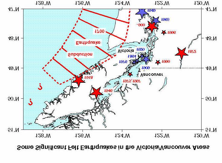
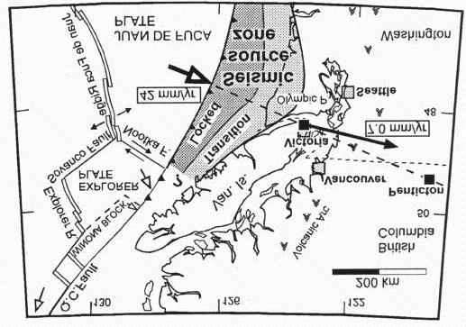
5 Seismicity Of Vancouver Vulnerability of Vancouver to earthquakes recognised relatively late Two sources of earthquakes:- Near field crustal earthquakes occurring in the crustal rock formations forming the North American plate Subduction earthquakes occurring in the Cascadia subduction zone appx 125 km off the west coast of Vancouver Island
6 Crustal Earthquakes Earthquakes due to slippage on fault lines located in underlying bedrock strata Can occur at relatively shallow depths with magnitudes typically less than M8 Can be very damaging if epicentre is located close to an urban area Pacific Northwest has a history of crustal earthquakes occurring every 20 to 40 years on average
7
8 Subduction Earthquakes Frequency of occurrence every 600 years Last subduction quake Jan 26th 1700 Typical magnitude Richter M8 - M9+ Fault length up to 1000 km Epicentre appx 200 km from Vancouver Shaking duration up to 4 min Notable EQ s Alaska 1964 (M9.2) and Chile 1960 (M9.5) - Two largest subduction EQ s
9 Subduction Earthquakes
10 Subduction Earthquakes
11 Development Of Seismic Building Regulations 1906 San Francisco earthquake 1933 Long Beach EQ & Field Act 1941 first edition of NBC 1953 NBC included seismic design 1967 Vancouver adopted 1960 NBC continued improvement 1990 major update with emphasis on ductility and good detailing
12 Vulnerability of Buildings in the City to effects of Earthquakes Earthquake resistance of buildings is highly dependent upon the age and type of building Earthquake codes and our technical knowledge have improved greatly over last 30 years, largely as a result of experience Buildings constructed prior to 1960 s are at increased risk Greatest risk is associated with unreinforced masonry buildings (URM s)
13 Vulnerability of Buildings in the City to Effects of Earthquakes Estimate appx 8,000 buildings of 3 storeys or more are vulnerable to earthquakes Seismic upgrading of URM s can take various levels of upgrading Bolts Plus is an effective and relatively inexpensive upgrade procedure for URM s which results in a good benefit/cost ratio.

14 Vancouver s Masonry Heritage

15 Vancouver s Masonry Heritage

16 Vancouver s Masonry Heritage

17 Vancouver s Masonry Heritage
18 United States Programs In Other Jurisdictions Most advanced of the Pacific Rim countries State of California requires municipalities to develop seismic mitigation plans NEHRP goals of achieving seismic resilience in two stages Many Californian municipalities have implemented seismic retrofit ordinances Northridge EQ has provided impetus for further mitigation work
19 New Zealand Programs In Other Jurisdictions Hawkes Bay earthquake of 1931 Seismic upgrading commenced 1964 for buildings undergoing major renovations Municipal councils empowered to require seismic upgrading of URM s Legislation currently before Minister to extend mandatory upgrading to other hazardous classes of buildings
20 Japan Programs In Other Jurisdictions Adopted stringent codes in 1971 & 1980 Existing buildings exempted from seismic provisions of 1980 building law Kobe earthquake revealed high vulnerability of older building stock to earthquakes Intensive efforts underway to address the risks of older non-conforming buildings using voluntary and government approaches
21 Structural Review Program Program to audit the quality of structural designs for new and upgraded buildings Commenced in 1996, appx 60 reviews carried out to date Results warrant continuation of some form of seismic peer review program Intent is to model the program along the lines of the building envelope specialist program
22 Seismic Mitigation Study Objectives and target areas Levels and methods of upgrading Costs of upgrading Socio-economic impacts Community involvement Incentives and voluntary upgrading Time frames
23 Seismic Reviews For New Buildings Adopt a facilitative system to achieve a conciliatory regulatory environment Provide for in-house screening of designs Work co-operatively with APEGBC to enhance existing concept review system Model approach on Building Envelope Program Continue modest program of structural audits Allow for cost recovery from designers who repeatedly fail to meet acceptable code standards
24 Seismic Specialist Roles & responsibilities Act as a strong technical resource to staff and the construction community Develop a public information program Co-ordinate development of seismic mitigation policy for the city Facilitate an improved regulatory system Administer structural review program Assist with further development of emergency response plans
25 Conclusions To develop a comprehensive seismic hazard abatement program To reduce seismic hazards with respect to existing and new buildings To substantially reduce the life-safety, economic and recovery impacts of a major earthquake To be funded from currently allocated building permit revenues
Earthquake Risk in Canada and the National Building Code
 Earthquake Risk in Canada and the National Building Code Tuna Onur, Ph.D. Onur Seemann Consulting, Inc. NICC, Vancouver, BC, 28-30 September 2016 Southwestern Canada: Cascadia Subduction Zone + Crustal
Earthquakes.
 Earthquakes http://thismodernworld.com/comic-archive Elastic rebound http://projects.crustal.ucsb.edu/understanding/elastic/rebound.html Elastic rebound Rocks store energy elastically When stored stress
9. GEOLOGY, SOILS, AND MINERALS
 June 28, 2018 Page 9-1 9. GEOLOGY, SOILS, AND MINERALS This EIR chapter describes the existing geological, soil, and mineral conditions in the planning area. The chapter includes the regulatory framework
Seismic risk assessment of conventional steel constructions to the hazard of three earthquake types in Southwestern British Columbia
 Seismic risk assessment of conventional steel constructions to the hazard of three earthquake types in Southwestern British Columbia F.E. Pina Department of Civil Engineering, Universidad de Santiago de
3D Seismic Hazard and Risk Maps for Earthquake Awareness of Citizens with Aids of GIS and Remote Sensing Technologies
 3D Seismic Hazard and Risk Maps for Earthquake Awareness of Citizens with Aids of GIS and Remote Sensing Technologies Saburoh Midorikawa Tokyo Institute of Technology In Japan, seismic hazard and risk
Downtown Anchorage Seismic Risk Assessment & Land Use Regulations to Mitigate Seismic Risk
 Prepared for: The Municipality of Anchorage Planning Department and the Geotechnical Advisory Commission Downtown Anchorage Seismic Risk Assessment & Land Use Regulations to Mitigate Seismic Risk Prepared
M 7.1 EARTHQUAKE 5KM ENE OF RABOSO, MEXICO EXACT LOCATION: N W DEPTH: 51.0KM SEPTEMBER 19, 1:14 LOCAL TIME
 M 7.1 EARTHQUAKE 5KM ENE OF RABOSO, MEXICO EXACT LOCATION: 18.584 N 98.399 W DEPTH: 51.0KM SEPTEMBER 19, 2017 @ 1:14 LOCAL TIME Photo: Eduardo Verdugo / AP Photo: Alfredo Estrella/ Agence France-Presse/
Earthquake Hazards in Henderson
 Earthquake Hazards in Henderson Craig M. depolo Nevada Bureau of Mines and Geology Nevada Hazard Mitigation Planning Committee November 15, 2012 Earthquake Truths The consequences of bad earthquakes to
M-8.1 EARTHQUAKE 87KM SW OF PIJIJIAPAN, MEXICO EXACT LOCATION: N W DEPTH: 69.7KM SEPTEMBER 7, 11:49 PST
 M-8.1 EARTHQUAKE 87KM SW OF PIJIJIAPAN, MEXICO EXACT LOCATION: 15.068 N 93.715 W DEPTH: 69.7KM SEPTEMBER 7, 2017 @ 11:49 PST Photo: Luis Alberto Cruz / AP Photo: Carlos Jasso 1 THE 2017 CHIAPAS MEXICO
Portland Water Bureau. Preparing Portland s Water Supply for The Big One. July 11, Tim Collins, P.E., G.E.
 Portland Water Bureau Preparing Portland s Water Supply for The Big One July 11, 2018 Tim Collins, P.E., G.E. Presentation Outline Portland water system overview Pacific Northwest seismic hazards Building
How to communicate Cascadia Subduction Zone earthquake hazards
 How to communicate Cascadia Subduction Zone earthquake hazards Tom Brocher Research Geophysicist Earthquake Science Center U.S. Geological Survey Menlo Park, California Seattle Post-Intelligencer Lessons
Three Fs of earthquakes: forces, faults, and friction. Slow accumulation and rapid release of elastic energy.
 Earthquake Machine Stick-slip: Elastic Rebound Theory Jerky motions on faults produce EQs Three Fs of earthquakes: forces, faults, and friction. Slow accumulation and rapid release of elastic energy. Three
Earthquake Hazards in Washoe County
 Earthquake Hazards in Washoe County Craig M. depolo Nevada Bureau of Mines and Geology Nevada Hazard Mitigation Planning Committee August 13, 2013 Earthquake Truths The consequences of damaging earthquakes
Measuring Disaster Risk for Urban areas in Asia-Pacific
 Measuring Disaster Risk for Urban areas in Asia-Pacific Acknowledgement: Trevor Clifford, Intl Consultant 1 SDG 11 Make cities and human settlements inclusive, safe, resilient and sustainable 11.1: By
Usually, only a couple of centuries of earthquake data is available, much shorter than the complete seismic cycle for most plate motions.
 Earthquake Hazard Analysis estimate the hazard presented by earthquakes in a given region Hazard analysis is related to long term prediction and provides a basis to expressed hazard in probabilistic terms.
EARTHQUAKES. Bruce A. Bolt. Fifth Edition. W. H. Freeman and Company New York. University of California, Berkeley
 EARTHQUAKES Fifth Edition Bruce A. Bolt University of California, Berkeley DS W. H. Freeman and Company New York Preface xi What We Feel in an Earthquake 1 The 1906 Eye-Opening San Francisco Earthquake
ADDITIONAL RESOURCES. Duration of resource: 30 Minutes. Year of Production: Stock code: VEA Resource written by: Andrew Clarke BA Dip Tchg
 ADDITIONAL RESOURCES The destructive and unexpected nature of earthquakes has remained a constant threat since civilisation began. Suitable for all secondary audiences, this two-part program firstly examines
158 Reducing Earthquake Losses
 ndex A Accelerographs, 64 Active control systems, 83-84 Active mass damping, 83 Active tendons, 83 Advocates, role of, 116 Air Force Office of Scientific Research, 133 Alaska, 42-43 Alquist-Priolo Act,
SEISMIC HAZARD ANALYSIS. Instructional Material Complementing FEMA 451, Design Examples Seismic Hazard Analysis 5a - 1
 SEISMIC HAZARD ANALYSIS Instructional Material Complementing FEMA 451, Design Examples Seismic Hazard Analysis 5a - 1 Seismic Hazard Analysis Deterministic procedures Probabilistic procedures USGS hazard
EARTHQUAKE HAZARDS AT SLAC. This note summarizes some recently published information relevant
 EARTHQUAKE HAZARDS AT SLAC SLAC-TN-76-1 John L. Harris January 1976 Summary This note summarizes some recently published information relevant to the expectation of damaging earthquakes at the SLAC site.
What is an earthquake?
 What is an earthquake? Shaking or vibration of the ground rocks undergoing deformation break suddenly along a fault 1906 San Francisco earthquake Oblique view of the San Andreas fault and San Francisco
Earthquake Hazards in Douglas County
 Earthquake Hazards in Douglas County Craig M. depolo Nevada Bureau of Mines and Geology Nevada Hazard Mitigation Planning Committee August 9, 2012 Earthquake Truths The consequences of bad earthquakes
Tectonic Processes and Hazards Enquiry Question 1: Why are some locations more at risk from tectonic hazards?
 Tectonic Processes and Hazards Enquiry Question 1: Why are some locations more at risk from tectonic hazards? Key words Basalt Andesite Rhyolite Benioff Zone Subduction zone Crustal fracturing Definition
COMMUNITY DEVELOPMENT DEPARTMENT POLICY & PROCEDURE
 COMMUNITY DEVELOPMENT DEPARTMENT POLICY & PROCEDURE Policy No: DSP-OO3 Release Date: January 1, 2014 Effective Date: January 1, 2014 Revision Date: March 1, 2018 TITLE: The City Policy for Site Specific
ASSESSING OREGON S SEISMIC RISK
 ASSESSING OREGON S SEISMIC RISK Martha Sartain 1 Richard Groff, P.E. 2 Craig Shike, P.E. 3 Mark Hirota, P.E. 4 Abstract The State of Oregon has unique seismic risks associated with its location adjacent
Surviving the Big One: Understanding and Preparing for a Major Earthquake in Western Oregon
 Surviving the Big One: Understanding and Preparing for a Major Earthquake in Western Oregon May 21, 2013 City of Salem Salem Public Library Althea Rizzo, Geological Hazards Program Coordinator Oregon Emergency
Overview. Tools of the Trade. USGS Decision-Making Tools for Pre-Earthquake Mitigation and Post-Earthquake Response
 USGS Decision-Making Tools for Pre-Earthquake Mitigation and Post-Earthquake Response Tools of the Trade DAVID WALD United States Geological Survey NEHRP Workshop: Developing Earthquake Scenarios Sept
WESTERN STATES SEISMIC POLICY COUNCIL POLICY RECOMMENDATION Earthquake and Tsunami Planning Scenarios
 WESTERN STATES SEISMIC POLICY COUNCIL POLICY RECOMMENDATION 18-1 Earthquake and Tsunami Planning Scenarios Policy Recommendation 18-1 WSSPC strongly encourages states, provinces, territories, First Nations,
Seismic Vulnerabilities of Multnomah County s Willamette River Bridges November 6, 2014
 Seismic Vulnerabilities of Multnomah County s Willamette River Bridges November 6, 2014 Ian Cannon, P.E. - Multnomah County Bridge Division Steve Drahota, P.E. - HDR Engineering, Inc. Response to the Budget
Washington State K 12 Facilities Pre-Disaster Mitigation Program Final Mitigation Plan
 Washington State K 12 Facilities Pre-Disaster Mitigation Program Final Mitigation Plan ESD Meeting, January 2015 Office of Superintendent of Public Instruction School Facilities & Organization 1 Mitigating
Earthquake. Hazard Identification & Risk Analysis. How to be Prepared
 Earthquake Hazard Identification & Risk Analysis & How to be Prepared In Vancouver and more specifically Dunbar What sort of catastrophic emergency risks do we need to prepare for? What sort of catastrophic
Baldwin County, Alabama
 2015 Baldwin County, Alabama Multi-Hazard Mitigation Plan I. Comprehensive Plan A multi-jurisdiction plan City of Bay Minette City of Daphne Town of Elberta City of Fairhope City of Foley City of Gulf
Lifelines mitigation in Hawke s Bay
 Lifelines mitigation in Hawke s Bay N.L. Evans Opus International Consultants (Member) NZSEE 2002 Conference ABSTRACT: This paper summarizes the findings of the recently completed Hawke s Bay Engineering
New Zealand Tsunami Vertical Evacuation. National guidance, best practice and design criteria
 New Zealand Tsunami Vertical Evacuation National guidance, best practice and design criteria New Zealand s Tsunami Risk Year of impact
Earthquakes and Earth s Interior
 - What are Earthquakes? Earthquakes and Earth s Interior - The shaking or trembling caused by the sudden release of energy - Usually associated with faulting or breaking of rocks - Continuing adjustment
Oregon APA Legal Issues Workshop December 7, Tricia Sears, DLCD With information from Bill Burns, DOGAMI
 Oregon APA Legal Issues Workshop December 7, 2018 Tricia Sears, DLCD With information from Bill Burns, DOGAMI How this Topic Arrived WE FREQUENTLY HEAR CONCERNS ABOUT LIABILITY AND TAKINGS. Current federal
Long Term Plan What is planned for Murchison?
 Long Term Plan 2018-2028 What is planned for Murchison? 1.0 Introduction The following information provides an overview of significant projects Council has planned for the Murchison settlement in the Long
M-6.2 EARTHQUAKE NORCIA, ITALY AUGUST 24, 01:36:33 UTC
 M-6.2 EARTHQUAKE NORCIA, ITALY AUGUST 24, 2016 @ 01:36:33 UTC EARTHQUAKE REPORT - NORCIA, ITALY M-6.2, 24 August 2016 The M-6.2 earthquake had a shallow depth (10 km) and struck approximately 10 km SE
Lecture 4: Earthquakes and Seismic Waves
 Lecture 4: Earthquakes and Seismic Waves Key Questions 1. What are the sources for EQs in the PNW? 2. What is a seismograph and seismogram? 3. What is the difference between Richter magnitudes and Mercalli
The Impact of the 2010 Darfield (Canterbury) Earthquake on the Geodetic Infrastructure in New Zealand 1
 Earthquake on the Geodetic Infrastructure in New Zealand 1") The Impact of the 2010 Darfield (Canterbury) Earthquake on the Geodetic Infrastructure in New Zealand 1 Graeme BLICK, John BEAVAN, Chris CROOK, Nic DONNELLY Keywords: Darfield Earthquake, control, survey,
The Impact of the 2010 Darfield (Canterbury) Earthquake on the Geodetic Infrastructure in New Zealand 1 Graeme BLICK, John BEAVAN, Chris CROOK, Nic DONNELLY Keywords: Darfield Earthquake, control, survey,
Application #: TEXT
 TOWN OF FORT MYERS BEACH 2008 PROPOSED COMPREHENSIVE PLAN AMENDMENTS Application #: 2008-13-TEXT Description: Modify the Coastal Management and Future Land Use Elements to reflect the state s new definition
Geologic Hazards. Geologic Setting
 Geologic Hazards Geologic Setting Geology for Planning: Central and Southeastern Marin County, California, published in 1976 by the California Geological Survey (formerly the California Division of Mines
In the early morning hours of
 Figure 1. Brace that Chimney! Bracing of masonry chimneys is very difficult to do properly and has generally been ineffective in preventing their failure during earthquakes. While replacement of the chimney
Earthquakes. & Expansive Soils
 Earthquakes & Expansive Soils January 22, 2009 Plan Update Flanagan & Associates, LLC Consultants Tulsa, OK www.rdflanagan.com rdflanagan@rdflanagan.com Plan can be reviewed at: www.rdflanagan.com/.html
Guidelines for Site-Specific Seismic Hazard Reports for Essential and Hazardous Facilities and Major and Special-Occupancy Structures in Oregon
 Guidelines for Site-Specific Seismic Hazard Reports for Essential and Hazardous Facilities and Major and Special-Occupancy Structures in Oregon By the Oregon Board of Geologist Examiners and the Oregon
Building earthquake early warning for the west coast. Ken Creager Professor of Earth and Space Sciences University of Washington
 Building earthquake early warning for the west coast Ken Creager Professor of Earth and Space Sciences University of Washington How Earthquake Early Warning works: P-waves S-waves 3-fold way of Earthquake
SEISMIC RISK ASSESSMENT IN ARMENIA
 SEISMIC RISK ASSESSMENT IN ARMENIA Hovhannes Khangeldyan Head of National Crisis Management Center Rescue Service Ministry of Emergency Situations of the Republic of Armenia Tokyo, 2016 ARMENIA: GEOGRAPHICAL
PAHRUMP REGIONAL PLANNING DISTRICT MASTER PLAN 2010
 CHAPTER TWENTY SEISMIC SAFETY PLAN (This Plan is from the 1999 Pahrump Regional Planning District Master Plan) Pursuant to NRS 278.160, this topic consists of an identification and appraisal of seismic
Cascadia megathrust earthquakes: reducing risk through science, engineering, and planning
 Cascadia megathrust earthquakes: reducing risk through science, engineering, and planning NSF Hazards SEES EAR-1331412 Urban Science and Engineering Workshop 21 July 2014 Everything to do with M9 Cascadia
Update on the It s Our Fault project
 Report 12.552 Date 29 October 2012 File 12/01/01 Committee Author CDEM Group Bruce Pepperell, Regional Manager, WREMO Update on the It s Our Fault project 1. Purpose To inform the CDEM Group of progress
APPLICATIONS OF EARTHQUAKE HAZARD MAPS TO LAND-USE AND EMERGENCY PLANNING EXAMPLES FROM THE PORTLAND AREA
 APPLICATIONS OF EARTHQUAKE HAZARD MAPS TO LAND-USE AND EMERGENCY PLANNING EXAMPLES FROM THE PORTLAND AREA O. Gerald Uba Metro, Portland, Oregon OVERVIEW The extent to which we understand "below ground"
The Coming Bay Area Earthquake Update
 The Coming Bay Area Earthquake - 2010 Update Scenario for a Magnitude 7.0 Earthquake on the Hayward Fault Northern California Chapter of the Earthquake Engineering Research Institute Janiele Maffei SE
Dark Sky Initiative Draft Terms of Reference
 Dark Sky Initiative Draft Terms of Reference July 2008 Table of Contents 1.0 Introduction 2 2.0 Initiative intent 2-3 3.0 Initiative goals 3 4.0 Legislation 3 5.0 Municipal Development Plan 3 6.0 Land
Spatial distribution of strong shaking near the 2-D source of large shallow New Zealand earthquakes
 Spatial distribution of strong shaking near the 2-D source of large shallow New Zealand earthquakes D.J. Dowrick 1 & D. A. Rhoades 2 1 Tauranga, New Zealand 2 GNS Science, Lower Hutt, New Zealand. 2007
Wainui Beach Management Strategy (WBMS) Summary of Existing Documents. GNS Tsunami Reports
 Summary of Existing Documents. GNS Tsunami Reports") Wainui Beach Management Strategy (WBMS) Summary of Existing Documents GNS Tsunami Reports a) Review of Tsunami Hazard and Risk in New Zealand ( National Risk Report ) b) Review of New Zealand s Preparedness
Wainui Beach Management Strategy (WBMS) Summary of Existing Documents GNS Tsunami Reports a) Review of Tsunami Hazard and Risk in New Zealand ( National Risk Report ) b) Review of New Zealand s Preparedness
Local Area Key Issues Paper No. 13: Southern Hinterland townships growth opportunities
 Draft Sunshine Coast Planning Scheme Review of Submissions Local Area Key Issues Paper No. 13: Southern Hinterland townships growth opportunities Key Issue: Growth opportunities for Southern Hinterland
KNOWLEDGE NOTE 5-1. Risk Assessment and Hazard Mapping. CLUSTER 5: Hazard and Risk Information and Decision Making. Public Disclosure Authorized
 Public Disclosure Authorized Public Disclosure Authorized Public Disclosure Authorized Public Disclosure Authorized KNOWLEDGE NOTE 5-1 CLUSTER 5: Hazard and Risk Information and Decision Making Risk Assessment
Probabilistic Seismic Hazard Maps in Dam Foundation
 Probabilistic Seismic Hazard Maps in Dam Foundation by Hideaki Kawasaki 1, Masafumi Kondo 2, Akira Nakamura 3, Kenji Inagaki 4 ABSTRACT Because Japan is one of the world s most earthquake prone countries,
Special Report: California Earthquake Preparedness and Vulnerabilities
 Special Report: California Earthquake Preparedness and Vulnerabilities January 2017 Earthquakes are common occurrences in California even more common than most residents realize. In 2014, California was
The Magnitude 7.2 Earthquake from the West Valley Fault: Implications for Metro Manila and Nearby Provinces
 The Magnitude 7.2 Earthquake from the West Valley Fault: Implications for Metro Manila and Nearby Provinces First DRI Collegiate Conference in the Philippines 16 March 2017 Renato U. Solidum, Jr. Department
Earthquakes in Canada
 Earthquakes in Canada Maurice Lamontagne, Ph.D., ing. Geological Survey of Canada Natural Resources Canada 1 What is an Earthquake? P S P S P PS 2 2 Movement on a fault plane causes vibrations The larger
Damage Estimation of the Road Bridge Structure Using the Seismic Hazard map for BCM in Hokkaido, Japan
 Damage Estimation of the Road Bridge Structure Using the Seismic Hazard map for BCM in Hokkaido, Japan T. Sato & H. Nishi Civil Engineerring Research Institute for Cold Region, PWRI,Japan T. Ikeda & Y.
Together towards a Sustainable Urban Agenda
 Together towards a Sustainable Urban Agenda The City We (Youth) Want Preliminary findings from youth consultations Areas Issue Papers Policy Units 1.Social Cohesion and Equity - Livable Cities 2.Urban
Word Cards. 2 map. 1 geographic representation. a description or portrayal of the Earth or parts of the Earth. a visual representation of an area
 Name: Date: Hour: Word Cards 1 geographic representation a description or portrayal of the Earth or parts of the Earth Example: A map is a representation of an actual location or place. 2 map a visual
Commentary Appendix A DEVELOPMENT OF MAXIMUM CONSIDERED EARTHQUAKE GROUND MOTION MAPS FIGURES THROUGH
 Commentary Appendix A DEVELOPMENT OF MAXIMUM CONSIDERED EARTHQUAKE GROUND MOTION MAPS FIGURES 3.3-1 THROUGH 3.3-14 BACKGROUND The maps used in the Provisions through 1994 provided the A a (effective peak
THE IMPACT OF LANDSLIDE AREAS ON MUNICIPAL SPATIAL PLANNING
 THE IMPACT OF LANDSLIDE AREAS ON MUNICIPAL SPATIAL PLANNING Jarosław Bydłosz, PhD Faculty of Mining Surveying and Environmental Engineering AGH University of Science and Technology e-mail: bydlosz@agh.edu.pl
New Zealand s Next Top Model: integrating tsunami modelling into land use planning
 New Zealand s Next Top Model: integrating tsunami modelling into land use planning Wendy Saunders (MZNZPI), Gegar Prasetya, Graham Leonard GNS Science, Lower Hutt, w.saunders@gns.cri.nz In April 2011 a
Earthquake Hazards. Tsunami
 Earthquake Hazards Tsunami Measuring Earthquakes Two measurements that describe the power or strength of an earthquake are: Intensity a measure of the degree of earthquake shaking at a given locale based
Date: June 19, 2013 Meeting Date: July 5, Consideration of the City of Vancouver s Regional Context Statement
 Section E 1.5 To: From: Regional Planning and Agriculture Committee Lee-Ann Garnett, Senior Regional Planner Planning, Policy and Environment Department Date: June 19, 2013 Meeting Date: July 5, 2013 Subject:
Mondo Quake in Pacific Northwest? By Leander Kahney
 Introduction to College Reading D Natural Disasters: Earthquake NAME I. Pre-reading. Discuss the following topics with other students at your table. What countries or regions of the world have earthquakes?
Chapter 2 Land Use Management and Risk Communication
 Chapter 2 Land Use Management and Risk Communication Michiko Banba Abstract Land use represents a relationship between natural and urban environment. Land use management is the way of managing land use
2014 Russell County Hazard Mitigation Plan Update STAKEHOLDERS AND TECHNICAL ADVISORS MEETING 2/6/14
 2014 Russell County Hazard Mitigation Plan Update STAKEHOLDERS AND TECHNICAL ADVISORS MEETING 2/6/14 Welcome and Introductions We cannot direct the wind, but we can adjust our sails. 44 CFR 201.6; Local
Earthquakes. Earthquake Magnitudes 10/1/2013. Environmental Geology Chapter 8 Earthquakes and Related Phenomena
 Environmental Geology Chapter 8 Earthquakes and Related Phenomena Fall 2013 Northridge 1994 Kobe 1995 Mexico City 1985 China 2008 Earthquakes Earthquake Magnitudes Earthquake Magnitudes Richter Magnitude
West Carroll Parish Hazard Mitigation Plan Update Public Meeting. August 25, 2015 Oak Grove, LA
 West Carroll Parish Hazard Mitigation Plan Update Public Meeting August 25, 2015 Oak Grove, LA Agenda Hazard Mitigation Planning Process SDMI Staff Risk Assessment SDMI Staff Update on Previous/Current
This article is provided courtesy of the American Museum of Natural History.
 Avoiding Earthquake Surprises in the Pacific Northwest This article is provided courtesy of the American Museum of Natural History. How Vulnerable Is the Pacific Northwest? Cascadia is a region in the
Internal Layers of the Earth
 Lecture #4 notes Geology 3950, Spring 2006; CR Stern Seismic waves, earthquake magnitudes and location, and internal earth structure (pages 28-95 in the 4 th edition and 28-32 and 50-106 in the 5 th edition)
Japan Quake: Why Do Humans Live In Dangerous Places? By Simon Saint
 Japan Quake: Why Do Humans Live In Dangerous Places? By Simon Saint What are some good things that volcanoes do? - Mount Saint Helens; Japan Earthquakes and Volcanoes; Eruptions; Rocks of the countries
Use this checklist for revision. Combine with textbook, revision websites and revision guide.
 Paper 1: Tectonics Use this checklist for revision. Combine with textbook, revision websites and revision guide. Lesson Title Spec Point Keywords Case Studies/Key skills Practiced Exam Questions Revised?
REPORT TO THE PLANNING, TRANSPORTATION AND PROTECTIVE SERVICES COMMITTEE MEETING OF JUNE 26, 2013
 PPS/PS 2013-07 REPORT TO THE PLANNING, TRANSPORTATION AND PROTECTIVE SERVICES COMMITTEE MEETING OF JUNE 26, 2013 SUBJECT UPDATES TO THE CAPITAL REGIONAL DISTRICT MODELLING OF POTENTIAL TSUNAMI INUNDATION
ShakeAlert Earthquake Early Warning
 ShakeAlert Earthquake Early Warning Doug Given USGS, Pasadena Earthquake Program, Early Warning Coordinator 10 seconds 50 seconds 90 seconds USGS Earthquake Hazard Responsibilities USGS has the lead federal
SUVA EARTHQUAKE RISK MANAGEMENT SCENARIO PILOT PROJECT (SERMP)
") SUVA EARTHQUAKE RISK MANAGEMENT SCENARIO PILOT PROJECT (SERMP) Jack RYNN 1, Josefa SERULAGILAGI 2, Atu KALOUMARIA 3 And Allan HULL 4 SUMMARY (Presented on behalf of the Government of the Republic of Fiji;
SUVA EARTHQUAKE RISK MANAGEMENT SCENARIO PILOT PROJECT (SERMP) Jack RYNN 1, Josefa SERULAGILAGI 2, Atu KALOUMARIA 3 And Allan HULL 4 SUMMARY (Presented on behalf of the Government of the Republic of Fiji;
TSUNAMI HAZARD MITIGATION ACTIVITIES IN CALIFORNIA
 10NCEE Tenth U.S. National Conference on Earthquake Engineering Frontiers of Earthquake Engineering July 21-25, 2014 Anchorage, Alaska TSUNAMI HAZARD MITIGATION ACTIVITIES IN CALIFORNIA R. I. Wilson 1,
Earthquake Hazards. Tsunami
 Earthquake Hazards Tsunami Review: What is an earthquake? Earthquake is the vibration (shaking) and/or displacement of the ground produced by the sudden release of energy. The point inside the Earth where
Seismic Vulnerability Assessment of Wood-frame Buildings in Southwestern British Columbia
 Seismic Vulnerability Assessment of Wood-frame Buildings in Southwestern British Columbia K. Goda University of Bristol, United Kingdom G.M. Atkinson University of Western Ontario, Canada ABSTRACT: The
Earthquake prediction. Earthquake prediction: animals?
 Earthquake prediction Prediction: specifies that an earthquake of a specific magnitude will occur in a defined region during a particular period: There will be a M 7 or larger earthquake in southern California
Earthquake prediction. Southwest BC: Our local dangerous fault zones
 Earthquake prediction Prediction: specifies that an earthquake of a specific magnitude will occur in a defined region during a particular period: There will be a M 7 or larger earthquake in southern California
Earthquake Hazards. Tsunami
 Earthquake Hazards Tsunami Review: What is an earthquake? Earthquake is the vibration (shaking) and/or displacement of the ground produced by the sudden release of energy. The point inside the Earth where
The Earthquake Cycle Chapter :: n/a
 The Earthquake Cycle Chapter :: n/a A German seismogram of the 1906 SF EQ Image courtesy of San Francisco Public Library Stages of the Earthquake Cycle The Earthquake cycle is split into several distinct
Important Concepts. Earthquake hazards can be categorized as:
 Lecture 1 Page 1 Important Concepts Monday, August 17, 2009 1:05 PM Earthquake Engineering is a branch of Civil Engineering that requires expertise in geology, seismology, civil engineering and risk assessment.
Hawke s Bay Liquefaction Hazard Report - Frequently Asked Questions
 Hawke s Bay Liquefaction Hazard Report - Frequently Asked Questions What is liquefaction? Liquefaction occurs when an earthquake shakes up water-logged sediments. As a result, the soil behaves like a liquid
To present information on the history, consequences, and existing threat of moderate to major eaythquakes in Arkansas.
 THE NATURE OF THE EARTHQUAKE THREAT OBJECTIVE To present information on the history, consequences, and existing threat of moderate to major eaythquakes in Arkansas. When people know what to expect in an
Earthquake. earthquake, epicenters in the U.S. Kobe, Japan deaths
 Kobe, Japan 1995 5000 deaths Earthquakes It is estimated that there are 500,000 detectable earthquakes in the world each year. 100,000 of those can be felt, and 100 of them cause damage. The world's deadliest
Report of the Working Group 2 Data Sharing and Integration for Disaster Management *
 UNITED NATIONS E/CONF.104/6 ECONOMIC AND SOCIAL COUNCIL Twentieth United Nations Regional Cartographic Conference for Asia and the Pacific Jeju, 6-9 October 2015 Item 5 of the provisional agenda Report
SHAKING AND GROUND FAILURE-INDUCED DAMAGE TO BUILDINGS BY THE 2010 AND 2011 CHRISTCHURCH EARTHQUAKES AND ITS LESSONS
 Int. Journal for Housing Science, Vol.36, No.3 pp.162-169, 2012 Published in the United States SHAKING AND GROUND FAILURE-INDUCED DAMAGE TO BUILDINGS BY THE 2010 AND 2011 CHRISTCHURCH EARTHQUAKES AND ITS
The Governance of Land Use
 The planning system Levels of government and their responsibilities The Governance of Land Use COUNTRY FACT SHEET NORWAY Norway is a unitary state with three levels of government; the national level, 19
I. Locations of Earthquakes. Announcements. Earthquakes Ch. 5. video Northridge, California earthquake, lecture on Chapter 5 Earthquakes!
 51-100-21 Environmental Geology Summer 2006 Tuesday & Thursday 6-9:20 p.m. Dr. Beyer Earthquakes Ch. 5 I. Locations of Earthquakes II. Earthquake Processes III. Effects of Earthquakes IV. Earthquake Risk
National Land Use Policy and National Integrated Planning Framework for Land Resource Development
 Title National Land Use Policy and National Integrated Planning Framework for Land Resource Development Duration: 32 Weeks Objective: Adoption of appropriate land use planning approaches to: Maintain the
Seismic site response analysis for Australia
 Seismic site response analysis for Australia Anita Amirsardari 1, Elisa Lumantarna 2, Helen M. Goldsworthy 3 1. Corresponding Author. PhD Candidate, Department of Infrastructure Engineering, University
Delta Flood Protection Strategy Update. May 16, 2016
 Delta Flood Protection Strategy Update May 16, 2016 Presentation Overview 1. Background 2. Understanding the Dike Reaches/Issues 3. Future Dike Improvements 4. Next Steps Boundary Bay Village March 10,
Societal issues in urban earthquake disasters: Lessons of the 2018 Osaka. Earthquake
 Societal issues in urban earthquake disasters: Lessons of the 2018 Osaka Earthquake Shingo Nagamatsu, Ph.D. Kansai University James Goltz, Ph.D. Kyoto University Anna Matsukawa, Ph.D. Disaster Reduction