Earthquake Hazards in Washoe County
|
|
|
- Sharyl Fisher
- 6 years ago
- Views:
Transcription
1 Earthquake Hazards in Washoe County Craig M. depolo Nevada Bureau of Mines and Geology Nevada Hazard Mitigation Planning Committee August 13, 2013
2

3
4 Earthquake Truths The consequences of damaging earthquakes to unprepared communities are unacceptable. We know how to plan for, prepare for, and mitigate against disastrous earthquake effects. We know how to minimize injuries and property loss.
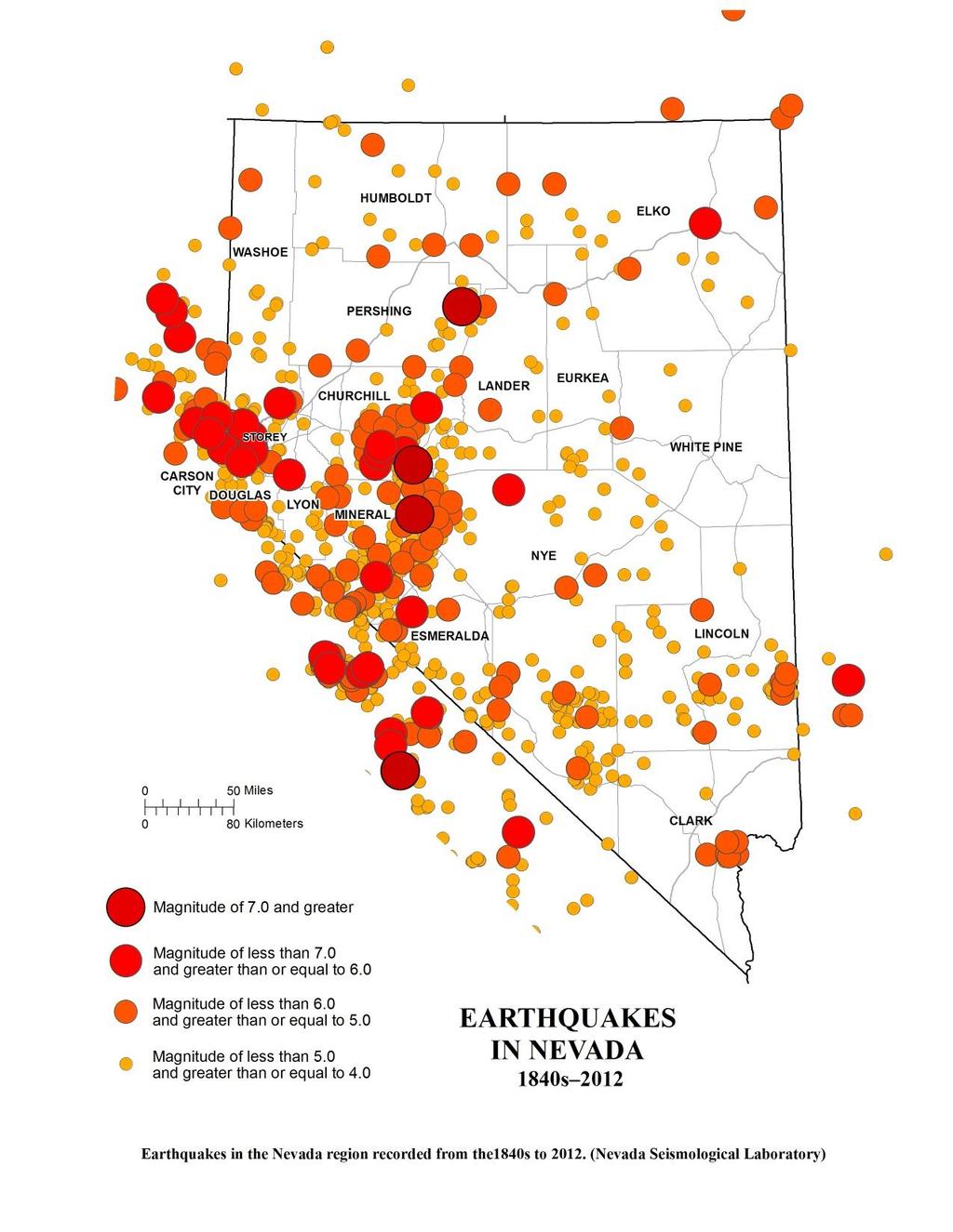
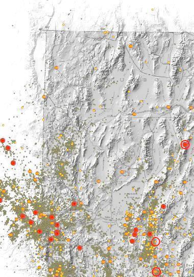
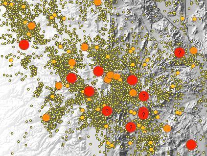
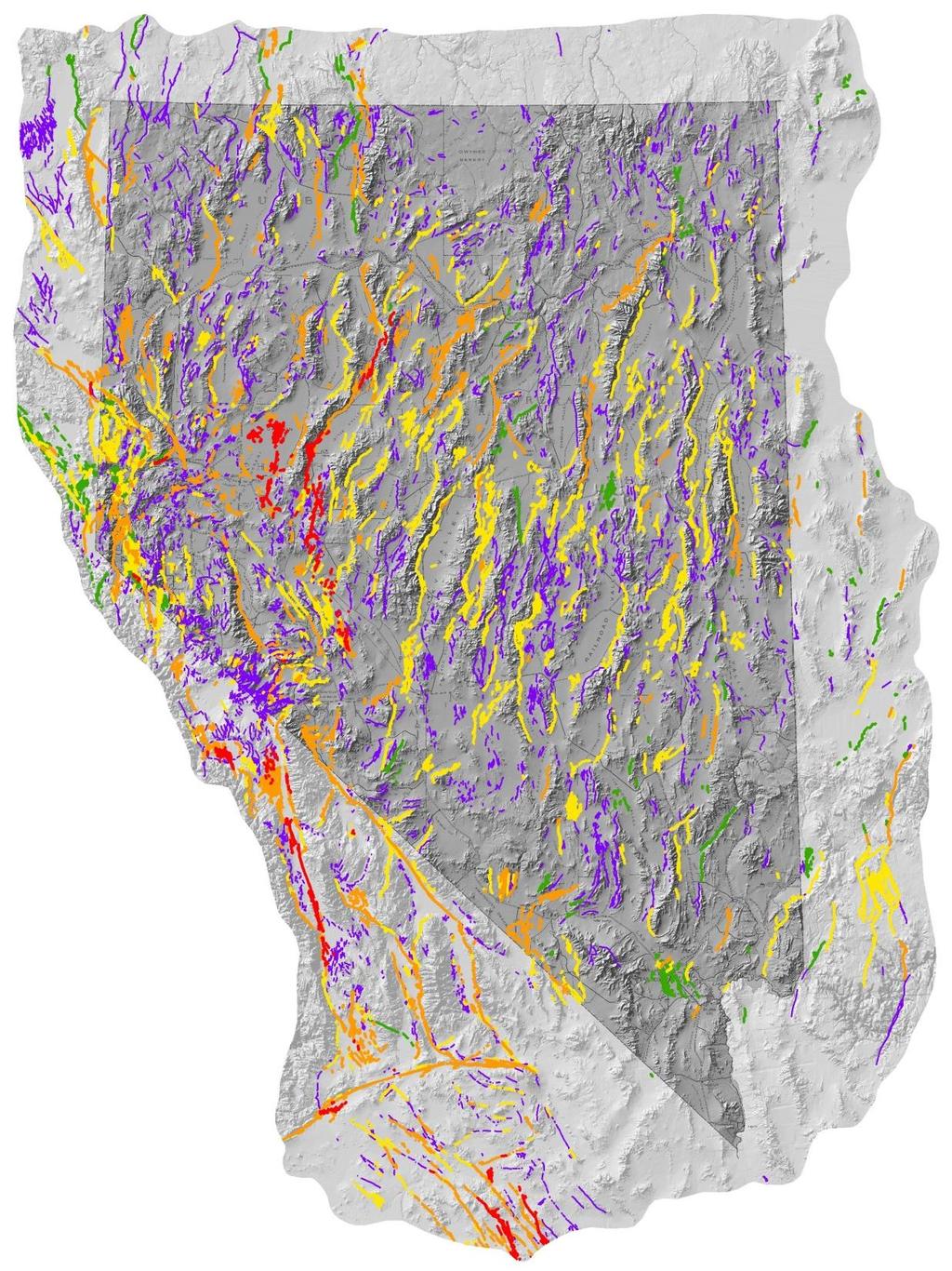
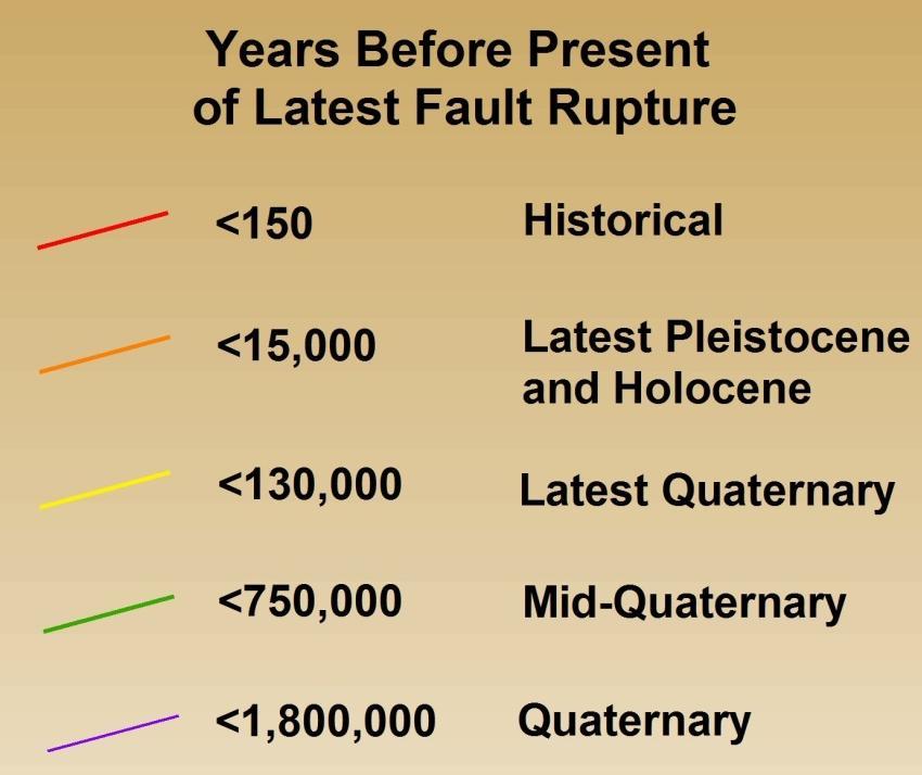
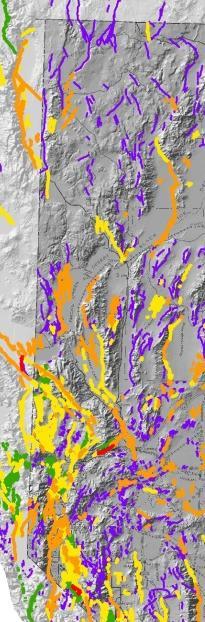
5 Earthquake Hazard Earthquakes Earthquake faults (Quaternary faults) Crustal movement based on geodesy
6
7
8
9

10
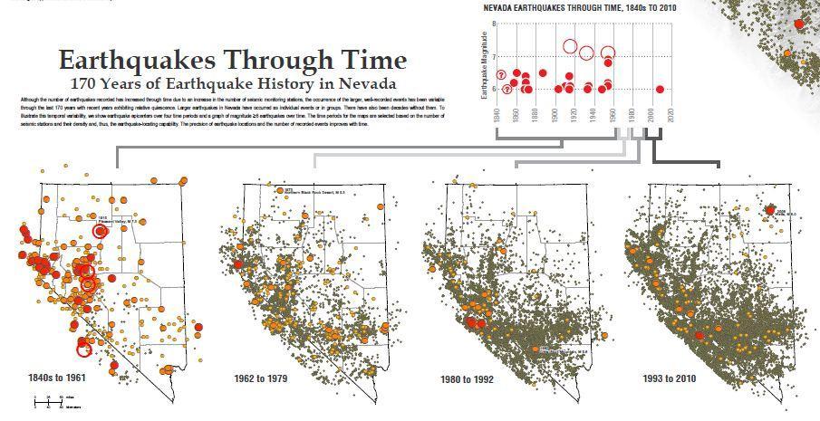
11 Periods of Damaging Earthquakes in Washoe County [1957, 1860, 1868, 1869(2)] [1914(2), 1915] [1948, 1953, 1954] 2008?
12 Preparing for earthquakes in Nevada will likely have a more than one time benefit.

13 1915 Pleasant Valley Earthquake; M 7.3 Modified Mercalli Intensity Map Modified from Stover and Coffman, 1993
14
15
16
")
17 Kreemer et al. (2012)


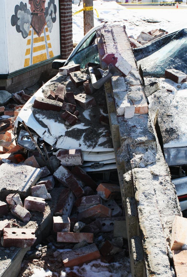
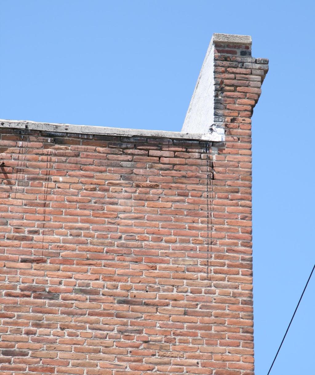
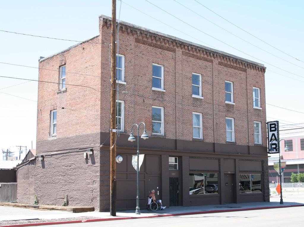
18 West of the San Andreas fault in California, the Pacific Plate is moving northwest relative to the North American Plate. Kreemer et al. (2012)

19
20 NBMG Open-File Report 09-8, Estimated Losses from Earthquakes near Nevada Communities, demonstrates that the consequences of earthquakes can be huge in Nevada, particularly if individuals are not prepared. HAZUS scenarios for magnitude 5.0, 5.5, 6.0, 6.5, and 7.0 earthquakes near 38 communities in Nevada. Large uncertainties in this modeling order-ofmagnitude estimates. Use for preparedness, response, and recovery plans and scenarios

21 2008 Mw 6.0 Wells Earthquake
22 HAZUS estimates for total economic loss from a magnitude 6.0 earthquake and probability of an earthquake of M 6 occurring within 50 years and within 31 mi (50 km) of the community. Estimated Probability Community Total Economic Loss M6 in 50 yrs w/in 31 mi Las Vegas $7.2 billion 12% Reno $1.9 billion 67% Sparks $1.8 billion 67% Carson City $650 million 70% Incline Village $510 million 60-70% Elko $160 million 10-15% Fallon $110 million 35% Gerlach $39 million 10-15% Wells $30 million 12% Total economic loss is from HAZUS. Probabilities are from the USGS at


23 Wells 12% chance M6 earthquake occurred Feb. 21, 2008
24 Earthquake faults occur throughout Nevada, and potential losses from earthquakes are high for many communities. A. Be prepared to respond. B. Mitigate structural risks, largely through building codes and avoiding faults and areas of liquefaction. C. Mitigate nonstructural risks.
25 Unreinforced Masonry Buildings


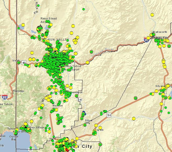
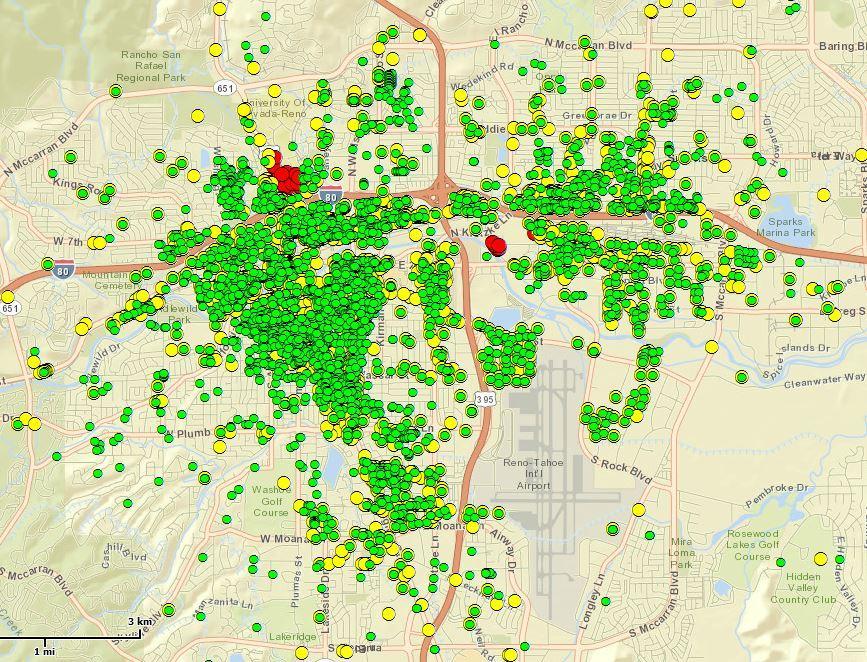
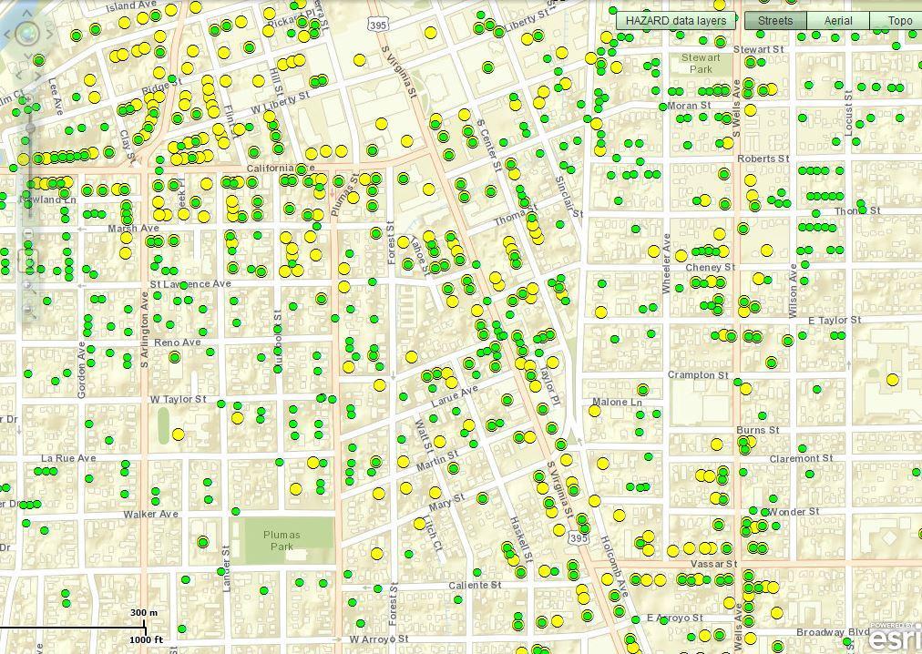
26 Unreinforced masonry building (URM) that collapsed during the Wells earthquake on 21 February 2008 View from back, 20 May 2009 View from front, 20 May 2009
27
28
29
30
31 Definition of potential unreinforced masonry (URM) buildings in Nevada: buildings listed by County Assessors or State Public Works as built before 1974 with brick, stone, or block masonry structure. Caution: This is a preliminary study based on data provided by county assessors and the State of Nevada. We know there are errors in the database: URMs missed - not recorded as masonry structures URMs missed ones on federal or Indian lands URMs counted due to wrong building type in the database Wrong locations due to poor address coding Misidentifications due to lack of construction date Buildings that may have been seismically retrofitted Buildings that have been removed. Recommendation 1 (draft): Jurisdictions (cities, counties, state) should use this County Assessors data to follow up with in-thefield inspections and checks of building plans. Individuals should determine if their buildings are URMs.
32 Potential URMs in Nevada 7,354 Residential 16,145 Commercial & Public (city and county) 98 State-owned 23,597 TOTAL* * The total does not include buildings owned by the federal government. NBMG Report 54 (2012)

33 Potential URMs Residential Commercial & Public State-owned
34 Potential URMs in Washoe County 3,322 Residential 2,445 Commercial & Public (city and county) 21 State-owned 5,788 TOTAL* * The total does not include buildings owned by the federal government. NBMG Report 54 (2012)
35
36
37
38

39 Nonstructural damage often can be easily prevented.

40 Great Nevada ShakeOut
41 Thank you! And thanks to Jon Price, Gary Johnson, Christine Ballard, Heather Armeno, Irene Seeley, Linda D. Goar, and Jordan T. Hastings for their work on the open-file reports (OF 09-8 and 09-9), which are available as online documents at From there, go to online documents at then scroll down to OF 09-8 or Link to the fault map from OF 09-9.
Earthquake Hazards in Douglas County
 Earthquake Hazards in Douglas County Craig M. depolo Nevada Bureau of Mines and Geology Nevada Hazard Mitigation Planning Committee August 9, 2012 Earthquake Truths The consequences of bad earthquakes
Earthquake Hazards in Henderson
 Earthquake Hazards in Henderson Craig M. depolo Nevada Bureau of Mines and Geology Nevada Hazard Mitigation Planning Committee November 15, 2012 Earthquake Truths The consequences of bad earthquakes to
Earthquake Faults, Historical Earthquakes, and Earthquake Preparedness. Craig depolo Nevada Bureau of Mines and Geology
 Earthquake Faults, Historical Earthquakes, and Earthquake Preparedness Craig depolo Nevada Bureau of Mines and Geology Earthquake Jack in the Box Analog Earthquake Faults = box and spring (bigger the
Foreshocks to Major Earthquakes In Nevada. Craig M. depolo Nevada Bureau of Mines and Geology
 Foreshocks to Major Earthquakes In Nevada Craig M. depolo Nevada Bureau of Mines and Geology Review foreshocks, particularly the 2008 Mogul earthquake, foreshock statistics and implications, multiple earthquakes
Layers (Layers in italics indicate group layers.) MyHazards MyPlan* Floods and Drought Landslides - USGS
 MyHazards MyPlan* Floods and Drought Landslides - USGS") MyHazards and MyPlan WebApps for Nevada Geohazards Over 100 hazard layers related to floods, fires, earthquakes, radon, and other supporting reference layers. Powerful educational and decision-making tools
MyHazards and MyPlan WebApps for Nevada Geohazards Over 100 hazard layers related to floods, fires, earthquakes, radon, and other supporting reference layers. Powerful educational and decision-making tools
WESTERN STATES SEISMIC POLICY COUNCIL POLICY RECOMMENDATION Earthquake and Tsunami Planning Scenarios
 WESTERN STATES SEISMIC POLICY COUNCIL POLICY RECOMMENDATION 18-1 Earthquake and Tsunami Planning Scenarios Policy Recommendation 18-1 WSSPC strongly encourages states, provinces, territories, First Nations,
Seismic Hazard Abatement Program
 Seismic Hazard Abatement Program Recommendations To take the first steps toward a seismic mitigation program for older existing buildings To improve our current regulatory system for implementation of
NEVADA EARTHQUAKE SAFETY COUNCIL c/o Nevada Bureau of Mines and Geology (775) Ext 126. February 17, 2009
 Ext 126. February 17, 2009") NEVADA EARTHQUAKE SAFETY COUNCIL c/o Nevada Bureau of Mines and Geology (775) 784-6691 Ext 126 University on Nevada, Reno (775) 784-1709 Fax Mail Stop 178 e-mail: jprice@unr.edu Reno, Nevada 89557-0088
NEVADA EARTHQUAKE SAFETY COUNCIL c/o Nevada Bureau of Mines and Geology (775) 784-6691 Ext 126 University on Nevada, Reno (775) 784-1709 Fax Mail Stop 178 e-mail: jprice@unr.edu Reno, Nevada 89557-0088
Mitigation Strategies for Earthquake Surface Rupture Hazard in the Basin and Range Province
 Mitigation Strategies for Earthquake Surface Rupture Hazard in the Basin and Range Province 1992 Landers, California Earthquake The Mitigation of Earthquake Surface Faulting in the Basin and Range Province:
Risk Identification using Hazus
 Risk Identification using Hazus City of Boston, Suffolk County, MA Dave Shortman, GISP, CFM 6/21/2016 Agenda Objective Project Location Hazus Overview Hazus Level 2 Risk Assessment Comparison and Reporting
M-8.1 EARTHQUAKE 87KM SW OF PIJIJIAPAN, MEXICO EXACT LOCATION: N W DEPTH: 69.7KM SEPTEMBER 7, 11:49 PST
 M-8.1 EARTHQUAKE 87KM SW OF PIJIJIAPAN, MEXICO EXACT LOCATION: 15.068 N 93.715 W DEPTH: 69.7KM SEPTEMBER 7, 2017 @ 11:49 PST Photo: Luis Alberto Cruz / AP Photo: Carlos Jasso 1 THE 2017 CHIAPAS MEXICO
M 7.1 EARTHQUAKE 5KM ENE OF RABOSO, MEXICO EXACT LOCATION: N W DEPTH: 51.0KM SEPTEMBER 19, 1:14 LOCAL TIME
 M 7.1 EARTHQUAKE 5KM ENE OF RABOSO, MEXICO EXACT LOCATION: 18.584 N 98.399 W DEPTH: 51.0KM SEPTEMBER 19, 2017 @ 1:14 LOCAL TIME Photo: Eduardo Verdugo / AP Photo: Alfredo Estrella/ Agence France-Presse/
PAHRUMP REGIONAL PLANNING DISTRICT MASTER PLAN 2010
 CHAPTER TWENTY SEISMIC SAFETY PLAN (This Plan is from the 1999 Pahrump Regional Planning District Master Plan) Pursuant to NRS 278.160, this topic consists of an identification and appraisal of seismic
HAZUS-MH: Earthquake Event Report
 HAZUS-MH: Earthquake Event Report Region Name: El Paso County Earthquake Scenario: El Paso County Random EQ Print Date: February 08, 2006 Disclaimer: The estimates of social and economic impacts contained
Downtown Anchorage Seismic Risk Assessment & Land Use Regulations to Mitigate Seismic Risk
 Prepared for: The Municipality of Anchorage Planning Department and the Geotechnical Advisory Commission Downtown Anchorage Seismic Risk Assessment & Land Use Regulations to Mitigate Seismic Risk Prepared
Usually, only a couple of centuries of earthquake data is available, much shorter than the complete seismic cycle for most plate motions.
 Earthquake Hazard Analysis estimate the hazard presented by earthquakes in a given region Hazard analysis is related to long term prediction and provides a basis to expressed hazard in probabilistic terms.
In the early morning hours of
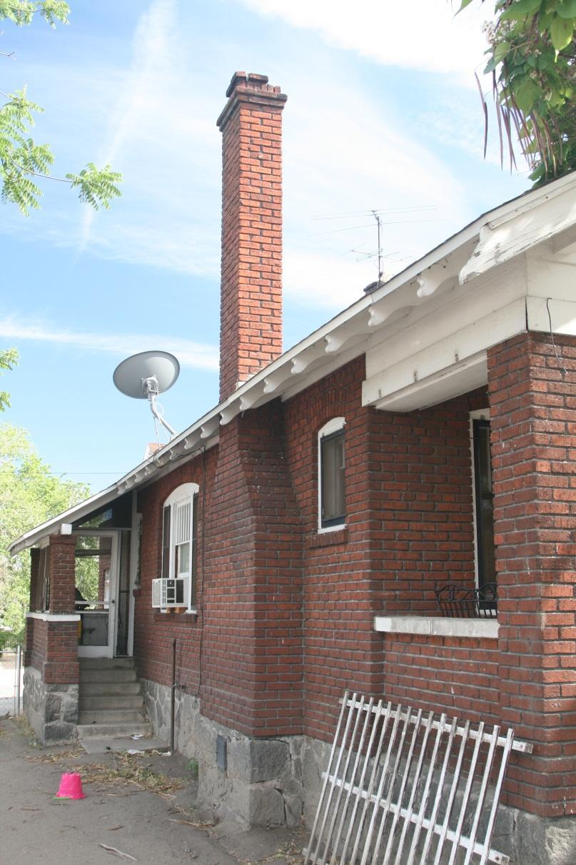
 Figure 1. Brace that Chimney! Bracing of masonry chimneys is very difficult to do properly and has generally been ineffective in preventing their failure during earthquakes. While replacement of the chimney
9. GEOLOGY, SOILS, AND MINERALS
 June 28, 2018 Page 9-1 9. GEOLOGY, SOILS, AND MINERALS This EIR chapter describes the existing geological, soil, and mineral conditions in the planning area. The chapter includes the regulatory framework
NPTEL Online - IIT Kanpur. Course Name Geotechnical Earthquake Engineering. Department IIT Kanpur
 NPTEL Online - IIT Kanpur Course Name Geotechnical Earthquake Engineering Department Instructor Civil Engineering Department IIT Kanpur Prof. N.R. Patra Module 1 INTRODUCTION TO GEOTECHNICAL ENGINEERING
Finding Fault Geologic History from a Road Cut
 Finding Fault Geologic History from a Road Cut Elisabeth M. Price, DD LaPointe, and Jonathan G. Price 4 July 2005 Introduction Earth science is an important science to present to students because it directly
NEVADA EARTHQUAKE SAFETY COUNCIL c/o Nevada Bureau of Mines and Geology (775) Ext 126
 Ext 126") TO: FROM: NEVADA EARTHQUAKE SAFETY COUNCIL c/o Nevada Bureau of Mines and Geology (775) 784-6691 Ext 126 University on Nevada, Reno (775) 784-1709 Fax Mail Stop 178 e-mail: jprice@unr.edu Reno, Nevada
TO: FROM: NEVADA EARTHQUAKE SAFETY COUNCIL c/o Nevada Bureau of Mines and Geology (775) 784-6691 Ext 126 University on Nevada, Reno (775) 784-1709 Fax Mail Stop 178 e-mail: jprice@unr.edu Reno, Nevada
RISK ASSESSMENT COMMUNITY PROFILE NATURAL HAZARDS COMMUNITY RISK PROFILES. Page 13 of 524
 RISK ASSESSMENT COMMUNITY PROFILE NATURAL HAZARDS COMMUNITY RISK PROFILES Page 13 of 524 Introduction The Risk Assessment identifies and characterizes Tillamook County s natural hazards and describes how
Updated MCE R & MCE G Ground Motions in 2015 NEHRP Provisions (& ASCE/SEI 7-16)
") Updated MCE R & MCE G Ground Motions in 2015 NEHRP Provisions (& ASCE/SEI 7-16) EERI 2016 Seminar ASCE Geotechnical on Next Generation & Structural Engineering Attenuation Congress Models Nicolas Luco
Updated MCE R & MCE G Ground Motions in 2015 NEHRP Provisions (& ASCE/SEI 7-16) EERI 2016 Seminar ASCE Geotechnical on Next Generation & Structural Engineering Attenuation Congress Models Nicolas Luco
Interpretive Map Series 24
 Oregon Department of Geology and Mineral Industries Interpretive Map Series 24 Geologic Hazards, Earthquake and Landslide Hazard Maps, and Future Earthquake Damage Estimates for Six Counties in the Mid/Southern
Resiliency Assessed by Comparing Scenarios
 Resiliency Assessed by Comparing Scenarios Robert A. Bauer Illinois State Geological Survey Use HAZUS to estimate losses from nearby strong events vs. NLE-11 New Madrid Catastrophic M7.7 and NLE-11 Mt.
High Probability of Foreshock Occurrence and Significant Probability of Multiple Events Associated with Magnitude 6 Earthquakes in Nevada, U.S.A.
 High Probability of Foreshock Occurrence and Significant Probability of Multiple Events Associated with Magnitude 6 Earthquakes in Nevada, U.S.A. by Craig M. depolo INTRODUCTION Sixty percent of magnitude
GPS Strain & Earthquakes Unit 4: GPS strain analysis examples Student exercise
 GPS Strain & Earthquakes Unit 4: GPS strain analysis examples Student exercise Example 1: Olympic Peninsula Name: Please complete the following worksheet to estimate, calculate, and interpret the strain
158 Reducing Earthquake Losses
 ndex A Accelerographs, 64 Active control systems, 83-84 Active mass damping, 83 Active tendons, 83 Advocates, role of, 116 Air Force Office of Scientific Research, 133 Alaska, 42-43 Alquist-Priolo Act,
HAZARD IDENTIFICATION AND VULNERABILITY ANALYSIS (HIVA) Walla Walla County, Washington EARTHQUAKE
 Walla Walla County, Washington EARTHQUAKE") HAZARD IDENTIFICATION AND VULNERABILITY ANALYSIS (HIVA) Walla Walla County, Washington Hazard Overview EARTHQUAKE An earthquake is caused by a sudden slip on a fault. Stresses in the earth's outer layer
HAZARD IDENTIFICATION AND VULNERABILITY ANALYSIS (HIVA) Walla Walla County, Washington Hazard Overview EARTHQUAKE An earthquake is caused by a sudden slip on a fault. Stresses in the earth's outer layer
Lab 9: Satellite Geodesy (35 points)
") Lab 9: Satellite Geodesy (35 points) Here you will work with GPS Time Series data to explore plate motion and deformation in California. This lab modifies an exercise found here: http://www.unavco.org:8080/cws/pbonucleus/draftresources/sanandreas/
Lab 9: Satellite Geodesy (35 points) Here you will work with GPS Time Series data to explore plate motion and deformation in California. This lab modifies an exercise found here: http://www.unavco.org:8080/cws/pbonucleus/draftresources/sanandreas/
FRIENDS OF THE EEL RIVER
 FRIENDS OF THE EEL RIVER Working for the recovery of our Wild & Scenic River, its fisheries and communities. Frank Blackett, Regional Engineer Office of Energy Projects Division of Dam Safety and Inspections
Earthquakes.
 Earthquakes http://thismodernworld.com/comic-archive Elastic rebound http://projects.crustal.ucsb.edu/understanding/elastic/rebound.html Elastic rebound Rocks store energy elastically When stored stress
New USGS Maps Identify Potential Ground- Shaking Hazards in 2017
 New USGS Maps Identify Potential Ground- Shaking Hazards in 2017 New USGS Maps Identify Potential Ground-Shaking Hazards in 2017 The central U.S. faces continued hazards from human-induced earthquakes
Geophysics 189 Natural Hazards Homework 2 Earthquake Locations and Hazards Due February 15, 2005
 Geophysics 189 Natural Hazards Homework 2 Earthquake Locations and Hazards Due February 15, 2005 Objective: The objective of this homework is to give you experience using real seismograms to locate an
Preliminary Earthquake Risk Management Strategy Plan of Eskisehir, Turkey by using GIS
 Preliminary Earthquake Risk Management Strategy Plan of Eskisehir, Turkey by using GIS Metin Altan, Ferah Özturk and Can Ayday Space and Satellite Sciences Research Institute Anadolu University, TURKEY
Minutes of the Nevada Hazard Mitigation Planning Committee Tuesday, May 7, 2013, at 12:30 pm
 Minutes of the Nevada Hazard Mitigation Planning Committee Tuesday, May 7, 2013, at 12:30 pm Tonopah Convention Center, 301 W. Brougher St. Tonopah, Nevada 89049, county seat of Nye County Before the meeting
PUBLIC COMMENT DRAFT 11/07/2016
 3.1 Earthquake Much of the Planning Area is susceptible to earthquake-induced landslides, liquefaction and severe ground shaking. A dense population and built environment in the cities of Gresham and Fairview
Hazard City Earthquake Damage Assessment Answers
 HAZARD CITY EARTHQUAKE DAMAGE ASSESSMENT ANSWERS PDF - Are you looking for hazard city earthquake damage assessment answers Books? Now, you will be happy that at this time hazard city earthquake damage
LANDUSE APPLICATIONS OF EARTHQUAKE HAZARD MAPS CALIFORNIA EXPERIENCE
 LANDUSE APPLICATIONS OF EARTHQUAKE HAZARD MAPS CALIFORNIA EXPERIENCE Thomas C. Vlasic Vice President Spangle Associates Portola Valley, California INTRODUCTION The focus of this report is primarily on
Before exploring the effects of the 1906 earthquake, watch the video on ground shaking and liquefaction at:
 Seismic Risk: Pre- Work Paper Maps Version Early on the morning of April 16, 1906, a magnitude 7.8 earthquake struck on the San Andreas Fault. The 1906 San Francisco earthquake revolutionized our understanding
Interpretive Map Series 24
 Oregon Department of Geology and Mineral Industries Interpretive Map Series 24 Geologic Hazards, and Hazard Maps, and Future Damage Estimates for Six Counties in the Mid/Southern Willamette Valley Including
FOURTH GRADE HAZARDS 1 WEEK LESSON PLANS AND ACTIVITIES
 FOURTH GRADE HAZARDS 1 WEEK LESSON PLANS AND ACTIVITIES PLATE TECTONIC CYCLE OVERVIEW OF FOURTH GRADE VOLCANOES WEEK 1. PRE: Comparing different structures of volcanoes. LAB: Modeling three types of volcanoes.
Geotechnical Extreme Events Reconnaissance Report:
 Geotechnical Extreme Events Reconnaissance Report: The Performance of Structures in Densely Urbanized Areas Affected by Surface Fault Rupture During the August 24, 2014 M6 South Napa Earthquake, California,
The L.A. Earthquake Sourcebook
 The L.A. Earthquake Sourcebook If searched for the ebook The L.A. Earthquake Sourcebook in pdf format, then you have come on to the faithful website. We furnish complete option of this ebook in doc, DjVu,
Name Date Class. radiate in all directions, carrying some of the. of plate boundaries have different usual patterns of.
 Chapter Outline Earthquakes CHAPTER 6 Lesson 1: Earthquakes and Plate Boundaries A. What is an earthquake? 1. A(n) is the rupture and sudden movement of rocks along a fault. A fault is a fracture surface
Basic Seismological Characterization for Platte County, Wyoming. James C. Case Wyoming State Geological Survey July, 2002 BACKGROUND
 Basic Seismological Characterization for Platte County, Wyoming by James C. Case Wyoming State Geological Survey July, 2002 BACKGROUND Seismological characterizations of an area can range from an analysis
Borah Peak Earthquake HAZUS Scenario Project Executive Summary Idaho Bureau of Homeland Security Idaho Geological Survey Western States Seismic
 Borah Peak Earthquake HAZUS Scenario Project Executive Summary Idaho Bureau of Homeland Security Idaho Geological Survey Western States Seismic Policy Council 12/30/2008 The HAZUS-MH analysis of the Borah
Earthquakes and Earth s Interior
 - What are Earthquakes? Earthquakes and Earth s Interior - The shaking or trembling caused by the sudden release of energy - Usually associated with faulting or breaking of rocks - Continuing adjustment
4.5 GEOLOGY, SOILS AND SEISMICITY
 4.5 This section summarizes information on geology, soils and seismic hazards, and mineral resources in the Truckee area, as well as potential area-wide geologic hazards and regional seismic characteristics
STRESS IN THE SYSTEM? INSIGHTS INTO MODELLING IN THE WAKE OF TOHOKU
 STRESS IN THE SYSTEM? INSIGHTS INTO MODELLING IN THE WAKE OF TOHOKU Aspen Re June 13, 2012 James Few President, Aspen Re Aspen Insurance Holdings Limited AGENDA Do we need near-term quake rates? Lessons
APPENDIX D REGION 5 ALL HAZARD MITIGATION PLAN EDITION PIERCE COUNTY OVERVIEW. Inherent Errors
 APPENDIX D REGION 5 ALL HAZARD MITIGATION PLAN 2015-2020 EDITION PIERCE COUNTY OVERVIEW This appendix contains the spatial results from the Hazus Earthquake Scenario results showing the Essential Facilities
Three Fs of earthquakes: forces, faults, and friction. Slow accumulation and rapid release of elastic energy.
 Earthquake Machine Stick-slip: Elastic Rebound Theory Jerky motions on faults produce EQs Three Fs of earthquakes: forces, faults, and friction. Slow accumulation and rapid release of elastic energy. Three
IV. ENVIRONMENTAL IMPACT ANALYSIS E. GEOLOGY AND SOILS
 IV. ENVIRONMENTAL IMPACT ANALYSIS E. GEOLOGY AND SOILS The following section is a summary of the geotechnical report conducted for the Proposed Project. The Geotechnical Engineering Investigation (the
Homework Assignment II. Seismological Exercises Fall 2014
 Page 1 of 8 EENS 3050 Tulane University Natural Disasters Prof. Stephen A. Nelson Homework Assignment II. Seismological Exercises Fall 2014 This page last updated on 03-Sep-2014 Answer the following questions.
4.1 Hazard Identification: Natural Hazards
 data is provided in an annex, it should be assumed that the risk and potential impacts to the affected jurisdiction are similar to those described here for the entire Sacramento County Planning Area. This
Baldwin County, Alabama
 2015 Baldwin County, Alabama Multi-Hazard Mitigation Plan I. Comprehensive Plan A multi-jurisdiction plan City of Bay Minette City of Daphne Town of Elberta City of Fairhope City of Foley City of Gulf
Special Report: California Earthquake Preparedness and Vulnerabilities
 Special Report: California Earthquake Preparedness and Vulnerabilities January 2017 Earthquakes are common occurrences in California even more common than most residents realize. In 2014, California was
GEOLOGY, SOILS, AND SEISMICITY
 4.9 GEOLOGY, SOILS, AND SEISMICITY 4.9.1 Introduction Information about the geological conditions and seismic hazards in the study area was summarized in the FEIR, and was based on the Geotechnical Exploration
4.6 GEOLOGIC AND SEISMIC HAZARDS
 4.6 GEOLOGIC AND SEISMIC HAZARDS The purpose of this Section is to describe the geologic and seismic setting of the Bakersfield Metropolitan area, identify potential impacts associated with implementation
Portland Water Bureau. Preparing Portland s Water Supply for The Big One. July 11, Tim Collins, P.E., G.E.
 Portland Water Bureau Preparing Portland s Water Supply for The Big One July 11, 2018 Tim Collins, P.E., G.E. Presentation Outline Portland water system overview Pacific Northwest seismic hazards Building
Homework Assignment II. Seismological Exercises Spring 2018
 Page 1 of 8 EENS 3050 Tulane University Natural Disasters Prof. Stephen A. Nelson Homework Assignment II. Seismological Exercises Spring 2018 This page last updated on 30-Jan-2018 Answer the following
Estimation of Short Term Shelter Needs FEMA Earthquake HAZUS Model
 July 2017 ESRI International Users Conference Estimation of Short Term Shelter Needs FEMA Earthquake HAZUS Model Techniques & Results Douglas Schenk / Sampa Patra GIS Group / Information Services Division
Seth J. Wittke Wyoming State Geological Survey
 Seth J. Wittke Wyoming State Geological Survey Project initiation Data manipulation Scenarios Creating the IMS Lessons learned County-wide block level probabilistic models created in 2004 for state mitigation
Cascadia megathrust earthquakes: reducing risk through science, engineering, and planning
 Cascadia megathrust earthquakes: reducing risk through science, engineering, and planning NSF Hazards SEES EAR-1331412 Urban Science and Engineering Workshop 21 July 2014 Everything to do with M9 Cascadia
The Coming Bay Area Earthquake Update
 The Coming Bay Area Earthquake - 2010 Update Scenario for a Magnitude 7.0 Earthquake on the Hayward Fault Northern California Chapter of the Earthquake Engineering Research Institute Janiele Maffei SE
 TABLE OF CONTENTS CHAPTER 1: SEISMIC HAZARDS... 1-1 1.1 SEISMIC CONTEXT EARTHQUAKE BASICS... 1-1 1.2 REGULATORY CONTEXT... 1-4 1.2.1 Alquist-Priolo Earthquake Fault Zoning Act... 1-4 1.2.2 Seismic Hazards
M-6.2 EARTHQUAKE NORCIA, ITALY AUGUST 24, 01:36:33 UTC
 M-6.2 EARTHQUAKE NORCIA, ITALY AUGUST 24, 2016 @ 01:36:33 UTC EARTHQUAKE REPORT - NORCIA, ITALY M-6.2, 24 August 2016 The M-6.2 earthquake had a shallow depth (10 km) and struck approximately 10 km SE
Earthquakes. Chapter Test A. Multiple Choice. Write the letter of the correct answer on the line at the left.
 Earthquakes Chapter Test A Multiple Choice Write the letter of the correct answer on the line at the left. 1. Stress that pushes a mass of rock in two opposite directions is called a. shearing. b. tension.
SHAKING AND GROUND FAILURE-INDUCED DAMAGE TO BUILDINGS BY THE 2010 AND 2011 CHRISTCHURCH EARTHQUAKES AND ITS LESSONS
 Int. Journal for Housing Science, Vol.36, No.3 pp.162-169, 2012 Published in the United States SHAKING AND GROUND FAILURE-INDUCED DAMAGE TO BUILDINGS BY THE 2010 AND 2011 CHRISTCHURCH EARTHQUAKES AND ITS
RISK OF PRINCIPAL DISASTERS IN INDIA AND IMPACTS OF DISASTERS ON ECONOMIC DEVELOPMENT
 RISK OF PRINCIPAL DISASTERS IN INDIA AND IMPACTS OF DISASTERS ON ECONOMIC DEVELOPMENT At the Himachal Pradesh Institute of Public Administration Shimla 05. 05.2012 Improve Disaster Management with the
4.5 GEOLOGY AND SOILS
 4.5 GEOLOGY AND SOILS This section addresses the project site geology and soils and analyzes potential changes that would result from development of the Wye Specific Plan project. 4.5.1 Environmental Setting
Disaster Risk Management in India. Kamal Kishore New Delhi, 27 October 2016
 Disaster Risk Management in India Kamal Kishore New Delhi, 27 October 2016 Hazard, Exposure and Vulnerability Disaster Prevention Mitigation Hurricane Matthew: Cuba & Haiti Emergency Response Coordination
EARTHQUAKES IN NEVADA
 EARTHQUAKES IN NEVADA and how to survive them Be Earthquake Safe in cooperation with Nevada Division of Emergency Management Beat the Quake! Nevada Bureau of Mines and Geology Special Publication E-16
SEISMIC HAZARD ANALYSIS. Instructional Material Complementing FEMA 451, Design Examples Seismic Hazard Analysis 5a - 1
 SEISMIC HAZARD ANALYSIS Instructional Material Complementing FEMA 451, Design Examples Seismic Hazard Analysis 5a - 1 Seismic Hazard Analysis Deterministic procedures Probabilistic procedures USGS hazard
Geologic Hazards. Geologic Setting
 Geologic Hazards Geologic Setting Geology for Planning: Central and Southeastern Marin County, California, published in 1976 by the California Geological Survey (formerly the California Division of Mines
COMPREHENSIVE GIS-BASED SOLUTION FOR ROAD BLOCKAGE DUE TO SEISMIC BUILDING COLLAPSE IN TEHRAN
 COMPREHENSIVE GIS-BASED SOLUTION FOR ROAD BLOCKAGE DUE TO SEISMIC BUILDING COLLAPSE IN TEHRAN B. Mansouri 1, R. Nourjou 2 and K.A. Hosseini 3 1 Assistant Professor, Dept. of Emergency Management, International
Preview Mode: ON Earthquake Risk in Stable, Intraplate Regions: the Case. of Perth, Australia. Historical Seismicity in the Perth Region
 Preview Mode: ON Earthquake Risk in Stable, Intraplate Regions: the Case Editor s note: There is often a tendency to discount earthquake risk in of Perth, Australia 02.2010 AIRCurrents regions where earthquakes
Geothermal Systems: Geologic Origins of a Vast Energy Resource
 Geothermal Systems: Geologic Origins of a Vast Energy Resource Energy From the Earth Energy-Land-Water Connections Speaker Series James E. Faulds, PhD Nevada State Geologist and Professor Nevada Bureau
Earthquakes. These icons indicate that teacher s notes or useful web addresses are available in the Notes Page.
 Earthquakes These icons indicate that teacher s notes or useful web addresses are available in the Notes Page. This icon indicates the slide contains activities created in Flash. These activities are not
Guidelines for Site-Specific Seismic Hazard Reports for Essential and Hazardous Facilities and Major and Special-Occupancy Structures in Oregon
 Guidelines for Site-Specific Seismic Hazard Reports for Essential and Hazardous Facilities and Major and Special-Occupancy Structures in Oregon By the Oregon Board of Geologist Examiners and the Oregon
Separating Tectonic, Magmatic, Hydrological, and Landslide Signals in GPS Measurements near Lake Tahoe, Nevada-California
 Separating Tectonic, Magmatic, Hydrological, and Landslide Signals in GPS Measurements near Lake Tahoe, Nevada-California Geoffrey Blewitt, Corné Kreemer, William C. Hammond, & Hans-Peter Plag NV Geodetic
Earth s Tectonic Plates
 MASTER 49 6.2 3.7 5.4 Philippine Pacific 5.4 North American Juan de Fuca Caribbean Cocos 10.0 9.2 2.3 2.5 2.3 1.8 3.0 Indian-Australian 10.5 7.1 17.2 16.8 6.0 Nazca South American 11.1 10.3 7.3 3.7 7.5
Module 2, Investigation 1: Earthquake Hazards
 Module 2, Investigation 1: Earthquake Hazards Introduction Welcome! In the last module, you assumed the role of a volcanologist and learned how volcanoes are described and monitored. You will now assume
How to communicate Cascadia Subduction Zone earthquake hazards
 How to communicate Cascadia Subduction Zone earthquake hazards Tom Brocher Research Geophysicist Earthquake Science Center U.S. Geological Survey Menlo Park, California Seattle Post-Intelligencer Lessons
September 28, 2004 Parkfield Earthquake
 PRELIMINARY REPORT ON SEPTEMBER 28, 2004 PARKFIELD EARTHQUAKE By Rakesh K. Goel, M.EERI and Charles B. Chadwell, M. EERI Department of Civil & Environmental Engineering, California Polytechnic State University,
Validation of Earthquake Simulations and Their Effects on Tall Buildings Considering Spectral Shape and Duration
 Validation of Earthquake Simulations and Their Effects on Tall Buildings Considering Spectral Shape and Duration SCEC Annual Meeting 2013 Ting Lin Marquette University Greg Deierlein Nenad Bijelic Stanford
CITY OF RIVERSIDE USING HAZUS TO CREATE A EARTHQUAKE PLANNING GUIDE FOR A UNIFIED FIELD RESPONSE
 CITY OF RIVERSIDE USING HAZUS TO CREATE A EARTHQUAKE PLANNING GUIDE FOR A UNIFIED FIELD RESPONSE Presented by the Phil McCormick City of Riverside Office of Emergency Management HISTORY The City had several
4.5 GEOLOGY AND SOILS
 4.5.1 Setting 4.5 GEOLOGY AND SOILS a. Regional Geology. The is located in the south central Santa Cruz Mountains in the heart of the Central Coast ranges of California. This is a seismically active region
IV. ENVIRONMENTAL IMPACT ANALYSIS G. GEOLOGY AND SOILS
 IV. ENVIRONMENTAL IMPACT ANALYSIS G. GEOLOGY AND SOILS The following section is a summary of the geotechnical report conducted for the proposed project. The Report of Geotechnical Investigation Proposed
Earthquake Risk in Canada and the National Building Code
 Earthquake Risk in Canada and the National Building Code Tuna Onur, Ph.D. Onur Seemann Consulting, Inc. NICC, Vancouver, BC, 28-30 September 2016 Southwestern Canada: Cascadia Subduction Zone + Crustal
HAZUS-MH: A Predictable Hurricane Risk Assessment Tool for the City of Houston and Harris County
 HAZUS-MH: A Predictable Hurricane Risk Assessment Tool for the City of Houston and Harris County Presented by Melvin G. Spinks, P.E., President Annie Ding, PhD, GISP October 29, 2008 Rice University Contents
What s Shaking in the Barnett Shale? STEP Dallas, August 11, 2015
 What s Shaking in the Barnett Shale? STEP Dallas, August 11, 2015 BSEEC.org @BSEEC Barnett Shale Facts The Barnett Shale was the first energy shale to be developed and therefore is the birthplace of the
The Magnitude 7.2 Earthquake from the West Valley Fault: Implications for Metro Manila and Nearby Provinces
 The Magnitude 7.2 Earthquake from the West Valley Fault: Implications for Metro Manila and Nearby Provinces First DRI Collegiate Conference in the Philippines 16 March 2017 Renato U. Solidum, Jr. Department
Washington State K 12 Facilities Pre-Disaster Mitigation Program Final Mitigation Plan
 Washington State K 12 Facilities Pre-Disaster Mitigation Program Final Mitigation Plan ESD Meeting, January 2015 Office of Superintendent of Public Instruction School Facilities & Organization 1 Mitigating
Overview. Tools of the Trade. USGS Decision-Making Tools for Pre-Earthquake Mitigation and Post-Earthquake Response
 USGS Decision-Making Tools for Pre-Earthquake Mitigation and Post-Earthquake Response Tools of the Trade DAVID WALD United States Geological Survey NEHRP Workshop: Developing Earthquake Scenarios Sept
Performing seismic scenarios in the Luchon-Val d Aran area, Central Pyrenees
 Performing seismic scenarios in the Luchon-Val d Aran area, Central Pyrenees 7th EUROGEO, Bologna, Italy, 12th-15th june 2012 Authors: A. Roullé (BRGM), A. Macau (IGC), S. Figueras (IGC), D. Monfort- Climent
Earthquakes. Earthquakes
 Earthquakes Profiling Hazard Event An earthquake happens when two blocks of the earth suddenly slip past one another, releasing built-up energy. The surface between these two blocks of earth is referred
Low-Latency Earthquake Displacement Fields for Tsunami Early Warning and Rapid Response Support
 Low-Latency Earthquake Displacement Fields for Tsunami Early Warning and Rapid Response Support Hans-Peter Plag, Geoffrey Blewitt Nevada Bureau of Mines and Geology and Seismological Laboratory University
2014 San Gabriel Valley Water Forum. October 2, 2014
 2014 San Gabriel Valley Water Forum October 2, 2014 Panel 3 Are we Ready? Flooding, Fires and Earthquakes Don Boland, California Utilities Emergency Association Southern California Catastrophic Earthquake
Summary Minutes Nevada Earthquake Safety Council 24 August 2001
 1 Summary Minutes Nevada Earthquake Safety Council 24 August 2001 The Nevada Earthquake Safety Council (NESC) met from 9:00 a.m. to 3:50 p.m. at the new Russell/Cameron Office of the Clark County Building