New USGS Maps Identify Potential Ground- Shaking Hazards in 2017
|
|
|
- Florence Jacobs
- 6 years ago
- Views:
Transcription

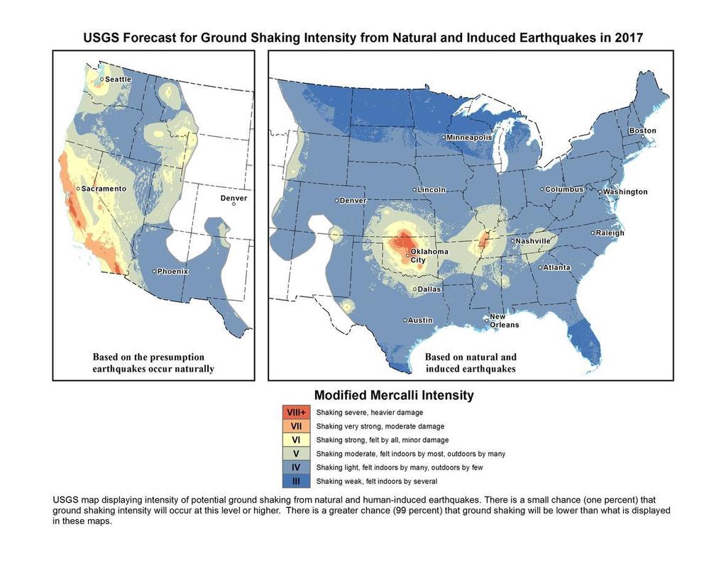
1 New USGS Maps Identify Potential Ground- Shaking Hazards in 2017 New USGS Maps Identify Potential Ground-Shaking Hazards in 2017 The central U.S. faces continued hazards from human-induced earthquakes Release Date: March 1, 2017 New USGS maps identify potential ground-shaking hazards in 2017 from both human-induced and natural earthquakes in the central and eastern U.S. Damage to buildings in Cushing, Oklahoma from the magnitude 5.0 earthquake on November 6, Unreinforced brick and stone masonry buildings and facades are vulnerable to strong shaking. Photograph credit: Dolan Paris, USGS
2 New USGS maps identify potential ground-shaking hazards in 2017 from both human-induced and natural earthquakes in the central and eastern U.S., known as the CEUS. This is the second consecutive year both types of hazards are forecasted, as previous USGS maps only identified hazards from natural earthquakes. This research was published today in Seismological Research Letters. Approximately 3.5 million people live and work in areas of the CEUS with significant potential for damaging shaking from induced seismicity in The majority of this population is in Oklahoma and southern Kansas. Research also shows that an additional half million people in the CEUS face a significant chance of damage from natural earthquakes in 2017, which brings the total number of people at high risk from both natural and human-induced earthquakes to about 4 million. The good news is that the overall seismic hazard for this year is lower than in the 2016 forecast, but despite this decrease, there is still a significant likelihood for damaging ground shaking in the CEUS in the year ahead, said Mark Petersen, chief of the USGS National Seismic Hazard Mapping Project. The 2017 forecast decreased compared to last year because fewer felt earthquakes occurred in 2016 than in This may be due to a decrease in wastewater injection resulting from regulatory actions and/or from a decrease in oil and gas production due to lower prices. Despite the decrease in the overall number of earthquakes in 2016, Oklahoma experienced the largest earthquake ever recorded in the state as well as the greatest number of large earthquakes compared to any prior year. Furthermore, the chance of damage from induced earthquakes will continue to fluctuate depending on policy and industry decisions, Petersen noted. The forecast for induced and natural earthquakes in 2017 is hundreds of times higher than before induced seismicity rates rapidly increased around 2008, said Petersen. Millions still face a significant chance of experiencing damaging earthquakes, and this could increase or decrease with industry practices, which are difficult to anticipate. Important Note: In the west, USGS scientists have focused on the hazard from natural earthquakes. Induced earthquakes have been observed in California as well, but they don t significantly change the regional hazard level, which is already high due to frequent natural earthquakes.

3 What are Induced Earthquakes? Induced earthquakes are triggered by human activities, with wastewater disposal being the primary cause in many areas of the CEUS. Wastewater from oil and gas operations can be disposed of by injecting it into deep underground wells. Injected fluids cause pressure changes that can weaken a fault and therefore bring it closer to failure. Most injection wells do not trigger felt earthquakes, suggesting that a combination of many factors contribute to such events. By understanding the relationship between earthquakes and wastewater injection, informed decisions can be made on processes such as controlling the volumes and rates of wastewater injected and determining which wells are most susceptible to inducing earthquakes, said Petersen. Many questions have been raised about hydraulic fracturing commonly referred to as fracking and more information can be found by reading common questions. States with High Hazard
4 The maps indicate an especially high ground-shaking hazard in five areas of the CEUS in These same areas were identified in the 2016 forecast. Induced seismicity poses the highest hazard in two areas, which are Oklahoma/southern Kansas and the Colorado/New Mexico area known as the Raton Basin. In those areas, there is a significant chance that damaging levels of ground motion will occur in Enhanced hazard from induced seismicity was also found in Texas and north Arkansas, but the levels are significantly lower in these regions than that forecasted for While earthquakes are still a concern, scientists did not observe significant activity in the past year, so the forecasted hazard is lower in There is also a high hazard for natural earthquakes in the New Madrid Seismic Zone. The NMSZ is the only one of the five identified areas that has not experienced induced earthquake activity. The NMSZ had a higher rate of natural earthquakes in the past three years, leading to a slightly higher hazard potential compared to previous years in portions of Arkansas, Missouri, Illinois, Kentucky and Tennessee. The 2016 forecast was quite accurate in assessing hazardous areas, especially in Oklahoma, said Petersen. Significant damage was experienced in Oklahoma during the past year as was forecasted in the 2016 model. However, the significantly decreased number of earthquakes in north Texas and Arkansas was not expected, and this was likely due to a decline in injection activity. There is specific concern in parts of the central U.S. since the forecasted hazard levels are higher than what is considered in current building codes, which only incorporate natural earthquakes, said Petersen. People living in areas of higher earthquake hazard should learn how to be prepared for earthquakes. Guidance can be found through FEMA s Ready Campaign. USGS charts showing the number of earthquakes greater than or equal to magnitude 2.7 since 1980 in the five focus areas identified as having especially high ground-shaking hazard in the central and eastern U.S. in Spotlight on Oklahoma Between 1980 and 2000, Oklahoma averaged about two earthquakes greater than or equal to magnitude 2.7 per year. However, this number jumped to about 2,500 in 2014, 4,000 in 2015 and 2,500 in The decline in 2016 may be due in part to injection restrictions implemented by the state officials. Of the earthquakes last year, 21 were greater than magnitude 4.0 and three were greater than magnitude 5.0.

5 USGS research considers a magnitude 2.7 earthquake to be the level at which ground shaking can be felt. An earthquake of magnitude 4.0 or greater can cause minor or more significant damage. The forecasted chance of damaging ground shaking in central Oklahoma is similar to that of natural earthquakes in high-hazard areas of California. Most of the damage we forecast will be cracking of plaster or unreinforced masonry. However, stronger ground shaking could also occur in some areas, which could cause more significant damage," said Petersen. USGS maps comparing the potential to experience damage from a natural or human-induced earthquake in Oklahoma in 2016 and Protecting Communities The new report is valuable for making informed decisions to reduce the nation s vulnerability and providing safety information to those who may be at risk from strong shaking. For example,

6 the 2016 forecast has been used by engineers to evaluate earthquake safety of buildings, bridges, pipelines and other important structures. Risk modelers have used data in developing new risk assessments, which can be used to better understand potential impa
7 cts on insurance premiums. The U.S. Army Corps of Engineers has used the information to provide guidance on updating their safety assessments of selected facilities. Continuing collaborations between regulators, industry, and scientists will be important toward reducing hazard, improving future forecasts, and enhancing preparedness. Central versus Western U.S. In recent years, the CEUS has experienced a significant increase in induced earthquakes. Therefore, in the 2017 and 2016 forecasts, scientists distinguish between human-induced and natural seismicity only for the CEUS. Scientists also used a historical catalog of seismic events dating back to the 1700s, putting a strong emphasis on earthquakes that occurred during the last 2 years. Future research, noted Petersen, could take a more detailed look at induced seismicity in the west, including in California at The Geysers, Brawley and small areas of the Los Angeles Basin. Distinguishing Between Induced and Natural Earthquakes To determine whether particular clusters of earthquakes were natural or induced, the USGS relied on published literature and discussions with state officials and the scientific and earthquake engineering community. Scientists looked at factors such as whether an earthquake occurred near a wastewater disposal well and whether the well was active during the time the earthquakes occurred. If so, it was classified as an induced event. One-Year Outlook The one-year outlook is chosen because induced earthquake activity can increase or decrease with time and is subject to commercial and policy decisions that could change rapidly. The 2016 and 2017 forecasts employ identical methodologies; the only difference is that the 2017 forecast includes an updated earthquake catalog with 2016 events. This allows for a direct comparison from one year to the next. In contrast, the USGS National Seismic Hazard Map assesses natural earthquake hazards and uses a 50-year forecast. That timeframe was chosen because that is the average lifetime of a building, and such information is essential to engineering design and the development of building codes. USGS Science The USGS is the only federal agency with responsibility for recording and reporting earthquake activity nationwide and assessing seismic hazard. These maps are part of USGS contributions to the National Earthquake Hazards Reduction Program, which is a congressionally established partnership of four federal agencies with the purpose of reducing risks to life and property in the United States that result from earthquakes.

8 USGS map displaying seismic events in 2015 and 2016 in the central and eastern U.S. There is a high hazard for earthquakes in five areas, which are Oklahoma-Kansas, the Raton Basin, north Texas, north Arkansas, and the New Madrid Seismic Zone.

9 USGS map showing the location of earthquakes greater than or equal to magnitude 4.0 in Oklahoma and the Raton Basin in 2016.
10 Adapted from: ; (8/18/17).
FAQs - Earthquakes Induced by Fluid Injection
 of 1 http://earthquake.usgs.gov/learn/faq/?categoryid=46&faqid=357 4/23/2012 9:26 PM Q: Does the production of natural gas from shales cause earthquakes? If so, how are the earthquakes related to these
Environmental Groups Warn Oklahoma Fracking Operators of Potential Legal Action
 Environmental Groups Warn Oklahoma Fracking Operators of Potential Legal Action Sierra Club & Public Justice Say Industry is Responsible for Increased Seismic Activity The following is the press release
Potential Injection-Induced Seismicity Associated With Oil & Gas Development
 Potential Injection-Induced Seismicity Associated With Oil & Gas Development A primer on technical & regulatory considerations informing risk management & mitigation Second Edition September, 2017 www.statesfirstinitiative.org
What s Shaking in the Barnett Shale? STEP Dallas, August 11, 2015
 What s Shaking in the Barnett Shale? STEP Dallas, August 11, 2015 BSEEC.org @BSEEC Barnett Shale Facts The Barnett Shale was the first energy shale to be developed and therefore is the birthplace of the
Recent Earthquakes in Oklahoma. and Potential for Induced Seismicity Austin Holland Oklahoma State Seismologist
 Recent Earthquakes in Oklahoma and the Mid-Continent: Significance and Potential for Induced Seismicity Austin Holland Oklahoma State Seismologist Outline Seismicity Rates in Mid-continent and Oklahoma
RISK ANALYSIS AND RISK MANAGEMENT TOOLS FOR INDUCED SEISMICITY
 Eleventh U.S. National Conference on Earthquake Engineering Integrating Science, Engineering & Policy June 25-29, 2018 Los Angeles, California RISK ANALYSIS AND RISK MANAGEMENT TOOLS FOR INDUCED SEISMICITY
Risk Treatment. Todd Shipman PhD, Alberta Geological Survey/Alberta Energy Regulator November 17 th,2017 Induced Seismicity Workshop, Yellowknife NWT
 Risk Treatment Todd Shipman PhD, Alberta Geological Survey/Alberta Energy Regulator November 17 th,2017 Induced Seismicity Workshop, Yellowknife NWT Risk Management Approach to Induced Seismicity Establishing
Julie Shemeta, MEQ Geo Inc., WCEE Webinar 1/13/2016 1/14/2016
 1/14/16 1 Julie Shemeta, MEQ Geo Inc., WCEE Webinar 1/13/2016 1/14/2016 WSJ, Nov 16, 2015 Women s Council on Energy and the Environment (WCEE) January 13, 2016 http://www.cpr.org 1/7/2016 http://stateimpact.npr.org/texas/tag/earthquake/
Geologic Hazards. Montour County Multi-jurisdictional. General. Earthquake
 Geologic Hazards General s are very rare in Pennsylvania and have caused little damage with no reported injuries or causalities. s that do occur in Pennsylvania happen deep within the Earth s crust. This
Induced Seismicity: Can it Happen in Kentucky Too?
 Induced Seismicity: Can it Happen in Kentucky Too? Seth Carpenter Seismologist Geologic Hazards Section 2015 KGS Annual Seminar Outline - What s the problem? - Earthquake magnitude - Types of induced seismic
Earthquakes. Earthquake Magnitudes 10/1/2013. Environmental Geology Chapter 8 Earthquakes and Related Phenomena
 Environmental Geology Chapter 8 Earthquakes and Related Phenomena Fall 2013 Northridge 1994 Kobe 1995 Mexico City 1985 China 2008 Earthquakes Earthquake Magnitudes Earthquake Magnitudes Richter Magnitude
#13 Earthquake Prediction
 #13 Earthquake Prediction Obvious importance Earthquake Prediction Save lives, reduce damage Earthquake Prediction - Types Long-range prediction - involves EQ probability over long time period (years to
The Richter Scale. Micro Less than 2.0 Microearthquakes, not felt. About 8,000/day
 Geologic Hazards General s are very rare in Pennsylvania and have caused very little damage and no reported injuries or casualties. Since the Commonwealth is not on an active fault, the earthquakes that
New Madrid and Central U.S. Region Earthquake Hazard
 New Madrid and Central U.S. Region Earthquake Hazard Rob Williams U.S. Geological Survey, Golden, CO March 16, 2017 Reelfoot Lake, TN U.S. Department of the Interior U.S. Geological Survey 1811-12 New
Risk Evaluation. Todd Shipman PhD, Alberta Geological Survey/Alberta Energy Regulator November 17 th,2017 Induced Seismicity Workshop, Yellowknife NWT
 Risk Evaluation Todd Shipman PhD, Alberta Geological Survey/Alberta Energy Regulator November 17 th,2017 Induced Seismicity Workshop, Yellowknife NWT Risk Management Approach to Induced Seismicity Establishing
Is It Safe to Frack Beneath Lake Lewisville?
 Is It Safe to Frack Beneath Lake Lewisville? Jerry Bartz, 2016 Data in this presentation are provisional and subject to revision and released on the condition that the author shall not be held liable for
COMPARING AND COMMUNICATING THE SEISMIC RISKS OF HYDRAULIC FRACTURING OF SHALE FOR NATURAL GAS OCTOBER 2014 GWPC ANNUAL FORUM SEATTLE, WA
 COMPARING AND COMMUNICATING THE SEISMIC RISKS OF HYDRAULIC FRACTURING OF SHALE FOR NATURAL GAS OCTOBER 2014 GWPC ANNUAL FORUM SEATTLE, WA DOES THIS SOUND FAMILIAR? A lot of residents became more frustrated
9. GEOLOGY, SOILS, AND MINERALS
 June 28, 2018 Page 9-1 9. GEOLOGY, SOILS, AND MINERALS This EIR chapter describes the existing geological, soil, and mineral conditions in the planning area. The chapter includes the regulatory framework
Earthquakes in Ohio? Teacher Directions and Lesson
 Earthquakes in Ohio? Teacher Directions and Lesson If I say, earthquake what state do you think of? Answers will vary, but California is a likely answer. What if I asked you, Where could you live in the
Seismic Hazard Switzerland. When, where, and how often does certain shaking occur in Switzerland?
 Seismic Hazard Switzerland When, where, and how often does certain shaking occur in Switzerland? Hazard The hazard map shows where and how often certain incidents of horizontal acceleration are likely.
Potential Injection-Induced Seismicity Associated with Oil & Gas Development:
 Potential Injection-Induced Seismicity Associated with Oil & Gas Development: A Primer on Technical and Regulatory Considerations Informing Risk Management and Mitigation Potential Injection-Induced Seismicity
Texas researchers dig into quake data Nathanial Gronewold, E&E News reporter Published: Thursday, January 18, 2018
 OIL Texas researchers dig into quake data Nathanial Gronewold, E&E News reporter Published: Thursday, January 18, 2018 Data published on the Bureau of Economic Geology's public TexNet portal show one year's
Identifying the causes and effects of earthquakes
 Science 3 Physical Earth and Space Life LESSON 57 Identifying the causes and effects of earthquakes Lesson Preparation Program Materials Child s Booklet E Exploring the Earth s Structure (pp. 12 13) Optional:
General Geologic Setting and Seismicity of the FHWA Project Site in the New Madrid Seismic Zone
 General Geologic Setting and Seismicity of the FHWA Project Site in the New Madrid Seismic Zone David Hoffman University of Missouri Rolla Natural Hazards Mitigation Institute Civil, Architectural & Environmental
focus seismic waves Earthquakes
 LESSON 3 fault line All of a sudden, Earth s crust shakes and solid land shifts. What causes an earthquake? How can an earthquake be measured? Read this selection to learn about earthquakes. Earthquakes
On Shaky Ground FRACKING, ACIDIZING, AND INCREASED EARTHQUAKE RISK IN CALIFORNIA EARTHWORKS TM
 On Shaky Ground FRACKING, ACIDIZING, AND INCREASED EARTHQUAKE RISK IN CALIFORNIA EARTHWORKS TM On Shaky Ground FRACKING, ACIDIZING, AND INCREASED EARTHQUAKE RISK IN CALIFORNIA MARCH 2014 AUTHORS: Jhon
Leveraging Cross-Disciplinary Science for Induced Seismicity Risk Management
 Transatlantic Knowledge Sharing Conference on Unconventional Hydrocarbons: Resources, Risks, Impact and Research Needs Session 1 Induced Seismicity Amsterdam June 20, 2017 Leveraging Cross-Disciplinary
National Wildland Significant Fire Potential Outlook
 National Wildland Significant Fire Potential Outlook National Interagency Fire Center Predictive Services Issued: September, 2007 Wildland Fire Outlook September through December 2007 Significant fire
How to communicate Cascadia Subduction Zone earthquake hazards
 How to communicate Cascadia Subduction Zone earthquake hazards Tom Brocher Research Geophysicist Earthquake Science Center U.S. Geological Survey Menlo Park, California Seattle Post-Intelligencer Lessons
Potential Injection-Induced Seismicity Associated with Oil & Gas Development:
 2015 Potential Injection-Induced Seismicity Associated with Oil & Gas Development: A Primer on Technical and Regulatory Considerations Informing Risk Management and Mitigation Potential Injection-Induced
5.2. IDENTIFICATION OF NATURAL HAZARDS OF CONCERN
 5.2. IDENTIFICATION OF NATURAL HAZARDS OF CONCERN To provide a strong foundation for mitigation strategies considered in Sections 6 and 9, County considered a full range of natural hazards that could impact
Usually, only a couple of centuries of earthquake data is available, much shorter than the complete seismic cycle for most plate motions.
 Earthquake Hazard Analysis estimate the hazard presented by earthquakes in a given region Hazard analysis is related to long term prediction and provides a basis to expressed hazard in probabilistic terms.
Real-Time Flood Forecasting Modeling in Nashville, TN utilizing HEC-RTS
 Real-Time Flood Forecasting Modeling in Nashville, TN utilizing HEC-RTS Brantley Thames, P.E. Hydraulic Engineer, Water Resources Section Nashville District, USACE August 24, 2017 US Army Corps of Engineers
Local Weather History
 Local Weather History 52 40- to 2+ 50-minute sessions ACTIVITY OVERVIEW P RO J E C T Students design and conduct a survey to learn about the history of weather disasters in the local area, and then compare
Earthquake Hazards in Henderson
 Earthquake Hazards in Henderson Craig M. depolo Nevada Bureau of Mines and Geology Nevada Hazard Mitigation Planning Committee November 15, 2012 Earthquake Truths The consequences of bad earthquakes to
Commentary Appendix A DEVELOPMENT OF MAXIMUM CONSIDERED EARTHQUAKE GROUND MOTION MAPS FIGURES THROUGH
 Commentary Appendix A DEVELOPMENT OF MAXIMUM CONSIDERED EARTHQUAKE GROUND MOTION MAPS FIGURES 3.3-1 THROUGH 3.3-14 BACKGROUND The maps used in the Provisions through 1994 provided the A a (effective peak
Seismic Source Characterization in Siting New Nuclear Power Plants in the Central and Eastern United States
 Seismic Source Characterization in Siting New Nuclear Power Plants in the Central and Eastern United States ABSTRACT : Yong Li 1 and Nilesh Chokshi 2 1 Senior Geophysicist, 2 Deputy Director of DSER Nuclear
United States Multi-Hazard Early Warning System
 United States Multi-Hazard Early Warning System Saving Lives Through Partnership Lynn Maximuk National Weather Service Director, Central Region Kansas City, Missouri America s s Weather Enterprise: Protecting
What We Know (and don t know)
") What We Know (and don t know) about the M5.1 La Habra Earthquake Dr. Robert Graves U.S. Geological Survey In collaboration with: Dr. Egill Hauksson and Dr. Thomas Göbel Caltech Dr. Elizabeth Cochran U.S.
What We Know (and don t know) about the M5.1 La Habra Earthquake Dr. Robert Graves U.S. Geological Survey In collaboration with: Dr. Egill Hauksson and Dr. Thomas Göbel Caltech Dr. Elizabeth Cochran U.S.
2.3 Notes: Earthquake Damage Can Be Reduced
 2.3 Notes: Earthquake Damage Can Be Reduced Earthquakes can cause severe damage and loss of life Each year, there is about one earthquake with a magnitude of or higher-this is an extremely earthquake.
M 7.1 EARTHQUAKE 5KM ENE OF RABOSO, MEXICO EXACT LOCATION: N W DEPTH: 51.0KM SEPTEMBER 19, 1:14 LOCAL TIME
 M 7.1 EARTHQUAKE 5KM ENE OF RABOSO, MEXICO EXACT LOCATION: 18.584 N 98.399 W DEPTH: 51.0KM SEPTEMBER 19, 2017 @ 1:14 LOCAL TIME Photo: Eduardo Verdugo / AP Photo: Alfredo Estrella/ Agence France-Presse/
Table One: Induced seismicity since 2011 in five previously aseismic Ohio counties. Locality County Year Induced Recorded Reference
 Merry Christmas Brookfield Here s Five Salt Water Injection Wells Dr. Raymond Beiersdorfer, Distinguished Professor of Geology Department of Geological and Environmental Sciences Youngstown State University,
Tornado Hazard Risk Analysis: A Report for Rutherford County Emergency Management Agency
 Tornado Hazard Risk Analysis: A Report for Rutherford County Emergency Management Agency by Middle Tennessee State University Faculty Lisa Bloomer, Curtis Church, James Henry, Ahmad Khansari, Tom Nolan,
Multi-Jurisdictional Hazard Mitigation Plan. Table C.10 The Richter Scale. Descriptor Richter Magnitude Earthquake Effects
 Geologic Hazards Earthquake Earthquakes are very rare in Pennsylvania and have caused little damage, with no reported injuries or causalities. Earthquakes that do occur in Pennsylvania happen deep within
Earthquakes. Earthquakes and Plate Tectonics. Earthquakes and Plate Tectonics. Chapter 6 Modern Earth Science. Modern Earth Science. Section 6.
 Earthquakes Chapter 6 Modern Earth Science Earthquakes and Plate Tectonics Section 6.1 Modern Earth Science Earthquakes and Plate Tectonics Earthquakes are the result of stresses in Earth s s lithosphere.
West Hollywood General Plan
 ITEM 2.RR. EXHIBIT B Providing a safe living environment is a fundamental goal and one of the most important challenges cities face today. Anticipating, planning for, and guarding against threats to public
Oklahoma Earthquakes: Trends and Underlying Causes. Jeremy Boak, Oklahoma Geological Survey October 21, 2016
 Oklahoma Earthquakes: Trends and Underlying Causes Jeremy Boak, Oklahoma Geological Survey jboak@ou.edu October 21, 2016 1 The Oklahoma Geological Survey is a state agency for research and public service
J.H. Campbell Generating Facility Pond A - Location Restriction Certification Report
 J.H. Campbell Generating Facility Pond A - Location Restriction Certification Report Pursuant to: 40 CFR 257.60 40 CFR 257.61 40 CFR 257.62 40 CFR 257.63 40 CFR 257.64 Submitted to: Consumers Energy Company
Author: Seth Stein, William Deering Professor of Earth & Planetary Sciences, Northwestern University. Background for Calais & Stein paper
 Background for Calais & Stein paper The GPS data reported here are important for understanding earthquakes in the central U.S. Large (magnitude 7) earthquakes on the New Madrid Fault system shook the Midwest
Preliminary Geotechnical Observations of the July 29, 2008 Southern California Earthquake
 Preliminary Geotechnical Observations of the July 29, 2008 Southern California Earthquake Provided for: Geo-Engineering Earthquake Reconnaissance (GEER) Association Prepared by: Pirooz Kashighandi, Salih
Rall Walsh and Mark Zoback
 Update to Oklahoma s Recent Earthquakes and Saltwater Disposal with 2014 Injection Data 1 Rall Walsh and Mark Zoback Fig. 1. Earthquakes and injection wells in Oklahoma. The map shows the locations of
Crop / Weather Update
 Crop / Weather Update This is our last for the 2018 planting, growing and harvesting seasons. USDA will publish their Crop Progress Report again in April 2019, and we will continue our coverage sometime
1 of 5 12/10/2018, 2:38 PM
 1 of 5 12/10/2018, 2:38 PM The depth of the rock layer that serves as the disposal site for wastewater produced during unconventional oil extraction plays a significant role in whether that disposal triggers
PAHRUMP REGIONAL PLANNING DISTRICT MASTER PLAN 2010
 CHAPTER TWENTY SEISMIC SAFETY PLAN (This Plan is from the 1999 Pahrump Regional Planning District Master Plan) Pursuant to NRS 278.160, this topic consists of an identification and appraisal of seismic
Article from: Risk Management. March 2009 Issue 15
 Article from: Risk Management March 2009 Issue 15 XXXXXXXXXXXXX RISK IDENTIFICATION Preparing for a New View of U.S. Earthquake Risk By Prasad Gunturi and Kyle Beatty INTRODUCTION The United States Geological
Regulatory Considerations for Evaluating the Potential for Induced Seismicity of a Class I Non-Hazardous Disposal Well
 Regulatory Considerations for Evaluating the Potential for Induced Seismicity of a Class I Non-Hazardous Disposal Well Chad Milligan, P.G.-SCS Engineers Craig Pangburn, P.G.-T&C Consulting Many Options
Assessment and Mitigation of Ground Motion Hazards from Induced Seismicity. Gail M. Atkinson
 Assessment and Mitigation of Ground Motion Hazards from Induced Seismicity Gail M. Atkinson (with acknowledgement to many collaborators, especially Ghofrani and Assatourians) NSERC/TransAlta/Nanometrics
Kansas Underground Injection Control Program & Induced Seismicity. By: Benjamin Busboom Stinson Leonard Street
 Kansas Underground Injection Control Program & Induced Seismicity By: Benjamin Busboom Stinson Leonard Street What is underground injection? Unground injection is used to place fluid underground into porous
Human-Induced Earthquakes from Deep-Well Injection: A Brief Overview
 Human-Induced Earthquakes from Deep-Well Injection: A Brief Overview Peter Folger Specialist in Energy and Natural Resources Policy Mary Tiemann Specialist in Environmental Policy December 22, 2014 Congressional
The Science and Policy of Natural Hazards
 Image courtesy of USGS. 12.103 Image courtesy of NOAA. The Science and Policy of Natural Hazards Image courtesy of USGS. Image courtesy of NOAA. Topics Four categories of hazards will be investigated in
Ivan Wong Seismic Hazards Group AECOM Oakland, CA. IEAGHG Monitoring Network Meeting. 10 June 2015
 Protocol and Best Practices for Addressing Induced Seismicity Associated With Enhanced Geothermal Systems (EGS) Ernie Majer Lawrence Berkeley National Laboratory Berkeley, CA and Ivan Wong Seismic Hazards
Geologic CO 2 Storage Options for California
 Geologic CO 2 Storage Options for California Larry Myer WESTCARB Technical Director California Energy Commission lrmyer@lbl.gov Carbon Capture & Sequestration Public Workshops February 13 14, 2008 Outline
20.1 Earthquakes. Chapter 20 EARTHQUAKES AND VOLCANOES. Earthquakes and plate boundaries 500 UNIT 6 EARTH S STRUCTURE
 Chapter 20 EARTHQUAKES AND VOLCANOES 20.1 Earthquakes In Chapter 19, you read about the San Andreas Fault, which lies along the California coast (Figure 20.1). This fault passes right through San Francisco
Estimation of Short Term Shelter Needs FEMA Earthquake HAZUS Model
 July 2017 ESRI International Users Conference Estimation of Short Term Shelter Needs FEMA Earthquake HAZUS Model Techniques & Results Douglas Schenk / Sampa Patra GIS Group / Information Services Division
Daily Operations Briefing. Thursday, July 6, :30 a.m. EDT
 Daily Operations Briefing Thursday, July 6, 2017 8:30 a.m. EDT Significant Activity July 5-6 Significant Events: None Tropical Activity: Atlantic Tropical Depression Four Eastern Pacific Disturbance 1:
White Paper on Induced Seismicity Related to Oil and Gas Development
 White Paper on Induced Seismicity Related to Oil and Gas Development Environmentally Friendly Drilling Systems (EFD) Program Houston Advanced Research Center (HARC) 4800 Research Forest Drive The Woodlands,
Preview Mode: ON Earthquake Risk in Stable, Intraplate Regions: the Case. of Perth, Australia. Historical Seismicity in the Perth Region
 Preview Mode: ON Earthquake Risk in Stable, Intraplate Regions: the Case Editor s note: There is often a tendency to discount earthquake risk in of Perth, Australia 02.2010 AIRCurrents regions where earthquakes
Earthquakes and Earth s Chapter. Interior
 Earthquakes and Earth s Chapter Interior 8.1 What Is an Earthquake? An earthquake is the vibration of Earth produced by the rapid release of energy Focus and Epicenter Focus is the point within Earth
Drought Impacts in the Southern Great Plains. Mark Shafer University of Oklahoma Norman, OK
 Drought Impacts in the Southern Great Plains Mark Shafer University of Oklahoma Norman, OK Causes of Drought: Large-Scale, Stationary High Pressure Air rotates clockwise around high pressure steers storms
Location Option Details. 1. Florida
 1. Florida Florida has the smallest number of earthquaes in the United States. Florida is the U.S. location where hurricanes are most frequent. Of the six deadliest hurricanes to hit the continental U.S.,
APPLICATIONS OF EARTHQUAKE HAZARD MAPS TO LAND-USE AND EMERGENCY PLANNING EXAMPLES FROM THE PORTLAND AREA
 APPLICATIONS OF EARTHQUAKE HAZARD MAPS TO LAND-USE AND EMERGENCY PLANNING EXAMPLES FROM THE PORTLAND AREA O. Gerald Uba Metro, Portland, Oregon OVERVIEW The extent to which we understand "below ground"
USGS: USGS: NEIC NEIC
 Triggered Earthquakes in North-Central Arkansas and their Relationship to Class II UIC Wells Scott M. Ausbrooks, The Arkansas Geological Survey Steve Horton, Ph.D., CERI at University i of Memphis Contributors:
5.2 IDENTIFICATION OF HAZARDS OF CONCERN
 5.2 IDENTIFICATION OF HAZARDS OF CONCERN 2016 HMP Update Changes The 2011 HMP hazard identification was presented in Section 3. For the 2016 HMP update, the hazard identification is presented in subsection
The L.A. Earthquake Sourcebook
 The L.A. Earthquake Sourcebook If searched for the ebook The L.A. Earthquake Sourcebook in pdf format, then you have come on to the faithful website. We furnish complete option of this ebook in doc, DjVu,
Phases of Disaster Response. John Yeaw, Gavin Vanstone, Haochen Wu, Jordan Tyler
 Phases of Disaster Response John Yeaw, Gavin Vanstone, Haochen Wu, Jordan Tyler BP Oil Spill One of the worst man made disasters in human history The BP oil spill occurred in April of 2010 when the Deepwater
How to Use This Presentation
 How to Use This Presentation To View the presentation as a slideshow with effects select View on the menu bar and click on Slide Show. To advance through the presentation, click the right-arrow key or
Earthquake Hazards in Douglas County
 Earthquake Hazards in Douglas County Craig M. depolo Nevada Bureau of Mines and Geology Nevada Hazard Mitigation Planning Committee August 9, 2012 Earthquake Truths The consequences of bad earthquakes
Missouri River Basin Water Management Monthly Update
 Missouri River Basin Water Management Monthly Update Participating Agencies 255 255 255 237 237 237 0 0 0 217 217 217 163 163 163 200 200 200 131 132 122 239 65 53 80 119 27 National Oceanic and Atmospheric
Weather and Climate Summary and Forecast Winter
 Weather and Climate Summary and Forecast Winter 2016-17 Gregory V. Jones Southern Oregon University February 7, 2017 What a difference from last year at this time. Temperatures in January and February
Earthquakes.
 Earthquakes http://thismodernworld.com/comic-archive Elastic rebound http://projects.crustal.ucsb.edu/understanding/elastic/rebound.html Elastic rebound Rocks store energy elastically When stored stress
Seismic Recording Station AZ_PFO Summary Report
 Seismic Recording Station AZ_PFO Summary Report Thank you for hosting station AZ_PFO on your property. We hope that you find the enclosed report interesting. Your station is one of the 2000 USArray seismic
 Red River Flooding June 2015 Caddo and Bossier Parishes Presented by: Flood Technical Committee Where the Rain Falls Matters I-30 versus I-20 I-20 Backwater and Tributary Floods (Localized) 2016 Flood
Tornadoes. Tornadoes COMMUNITY EMERGENCY RESPONSE TEAM TORNADOES
 Tornadoes Tornadoes Tell the participants that tornadoes are powerful, circular windstorms that may be accompanied by winds in excess of 200 miles per hour. Tornadoes typically develop during severe thunderstorms
M-8.1 EARTHQUAKE 87KM SW OF PIJIJIAPAN, MEXICO EXACT LOCATION: N W DEPTH: 69.7KM SEPTEMBER 7, 11:49 PST
 M-8.1 EARTHQUAKE 87KM SW OF PIJIJIAPAN, MEXICO EXACT LOCATION: 15.068 N 93.715 W DEPTH: 69.7KM SEPTEMBER 7, 2017 @ 11:49 PST Photo: Luis Alberto Cruz / AP Photo: Carlos Jasso 1 THE 2017 CHIAPAS MEXICO
Earthquake Hazards in Washoe County
 Earthquake Hazards in Washoe County Craig M. depolo Nevada Bureau of Mines and Geology Nevada Hazard Mitigation Planning Committee August 13, 2013 Earthquake Truths The consequences of damaging earthquakes
Global Forecast Map: IRI Seasonal Forecast for Precipitation (rain and snow) over May July 2011, issued on 21 April 2011.
 over May July 2011, issued on 21 April 2011.") 21 April 2011 -Global La Niña Update Produced by the Red Cross/Red Crescent Climate Centre and the International Research Institute for Climate and Society This update contains: - A global La Niña update
21 April 2011 -Global La Niña Update Produced by the Red Cross/Red Crescent Climate Centre and the International Research Institute for Climate and Society This update contains: - A global La Niña update
158 Reducing Earthquake Losses
 ndex A Accelerographs, 64 Active control systems, 83-84 Active mass damping, 83 Active tendons, 83 Advocates, role of, 116 Air Force Office of Scientific Research, 133 Alaska, 42-43 Alquist-Priolo Act,
Induced Seismicity Potential in Energy Technologies
 Induced Seismicity Potential in Energy Technologies Conducted by the National Research Council s Committee on Induced Seismicity Potential in Energy Technologies Sponsor Department of Energy Overseen by
Hawke s Bay Liquefaction Hazard Report - Frequently Asked Questions
 Hawke s Bay Liquefaction Hazard Report - Frequently Asked Questions What is liquefaction? Liquefaction occurs when an earthquake shakes up water-logged sediments. As a result, the soil behaves like a liquid
Red River Levee Panel
 Red River Levee Panel Mississippi River Commission Monday, August 9, 2017 Red River Levees in LA & AR NONE along TX & OK Boarder Red River Levee Issues Caddo Levee Cherokee Park Authorization Bossier Levee
Unraveling the Mysteries of Seismicity in Oklahoma. A Story Map
 Unraveling the Mysteries of Seismicity in Oklahoma A Story Map Background Why create a story map? Visualization of various types of data (graphics, text, symbols, etc.) within a geographical context to
DEPARTMENT OF GEOLOGY AND MINERAL INDUSTRIES WAYS & MEANS SUBCOMMITTEE ON NATURAL RESOURCES MARCH 2, 2017
 DEPARTMENT OF GEOLOGY AND MINERAL INDUSTRIES WAYS & MEANS SUBCOMMITTEE ON NATURAL RESOURCES MARCH 2, 2017 1 ABOUT DOGAMI AGENCY MISSION, VISION & GOALS 2 Lidar image of a stream network along the Umpqua
In the early morning hours of
 Figure 1. Brace that Chimney! Bracing of masonry chimneys is very difficult to do properly and has generally been ineffective in preventing their failure during earthquakes. While replacement of the chimney
Earthquakes in Canada
 Earthquakes in Canada Maurice Lamontagne, Ph.D., ing. Geological Survey of Canada Natural Resources Canada 1 What is an Earthquake? P S P S P PS 2 2 Movement on a fault plane causes vibrations The larger
Interpretive Map Series 24
 Oregon Department of Geology and Mineral Industries Interpretive Map Series 24 Geologic Hazards, and Hazard Maps, and Future Damage Estimates for Six Counties in the Mid/Southern Willamette Valley Including
Geotechnical Aspects of the Seismic Update to the ODOT Bridge Design Manual. Stuart Edwards, P.E Geotechnical Consultant Workshop
 Geotechnical Aspects of the Seismic Update to the ODOT Bridge Design Manual Stuart Edwards, P.E. 2017 Geotechnical Consultant Workshop Changes Role of Geotechnical Engineer Background Methodology Worked
Missouri River Basin Water Management Monthly Update
 Missouri River Basin Water Management Monthly Update Participating Agencies 255 255 255 237 237 237 0 0 0 217 217 217 163 163 163 200 200 200 131 132 122 239 65 53 80 119 27 National Oceanic and Atmospheric
Tropical Update. 5 AM EDT Thursday, September 7, 2017 Hurricane Irma, Hurricane Jose, and Hurricane Katia
 Tropical Update 5 AM EDT Thursday, September 7, 2017 Hurricane Irma, Hurricane Jose, and Hurricane Katia This update is intended for government and emergency response officials, and is provided for informational
Risk Management of Induced Seismicity: Technical Elements & Research Opportunities
 October 30, 2014 Risk Management of Induced Seismicity: Technical Elements & Research Opportunities K. J. (Kris) Nygaard, ExxonMobil Upstream Research Company U.S. Department of Energy Informational Briefing
2014 Emergency Preparedness Conference. Tuesday, June 3, 2014 The Wildwoods Convention Center 4501 Boardwalk Wildwood, New Jersey 08260
 2014 Emergency Preparedness Conference Tuesday, June 3, 2014 The Wildwoods Convention Center 4501 Boardwalk Wildwood, New Jersey 08260 A Look back at Winter 2013-2014 A Look ahead to the 2014 Hurricane