Earthquakes. & Expansive Soils
|
|
|
- Spencer Marshall
- 6 years ago
- Views:
Transcription

1 Earthquakes & Expansive Soils January 22, 2009 Plan Update


2 Flanagan & Associates, LLC Consultants Tulsa, OK Plan can be reviewed at:
3 Overview of Process Step 1: Step 2: Step 3: Organize to Prepare the Plan Involve the Public Coordinate with Other Agencies and Organizations Step 4: Assess the Step 5: Assess the Problem (i.e., Specific Vulnerabilities) Step 6: Set Goals (i.e., Priorities Based Upon Assessments) Step 7: Review Possible Activities (i.e., Measures) Step 8: Step 9: Draft the Action Plan Adopt the Plan Step 10: Monitor, Evaluate, and Update Chapter 7
4 Earthquakes


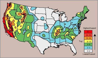
5 Relative Risk of Earthquakes across the United States Earthquakes
6 Overview of the Richter Scale Scale Micro <2.0 Very Minor Minor Light Moderate Effects Microearthquakes, not felt Generally not felt, but recorded Often felt, rarely causes damage. Noticeable shaking of indoor items, rattling noises. Significant damage unlikely Can cause major damage to poorly constructed buildings over small regions. At most slight damage to well-designed buildings Earthquakes
7 Overview of the Richter Scale Cont. Scale Strong Major Great Massive Epic >10.0 Can be destructive in areas up to about 100 miles across in populated areas Can cause serious damage over larger areas Can cause serious damage in areas several hundred miles across Devastating in areas several thousand miles across Never recorded Effects Earthquakes
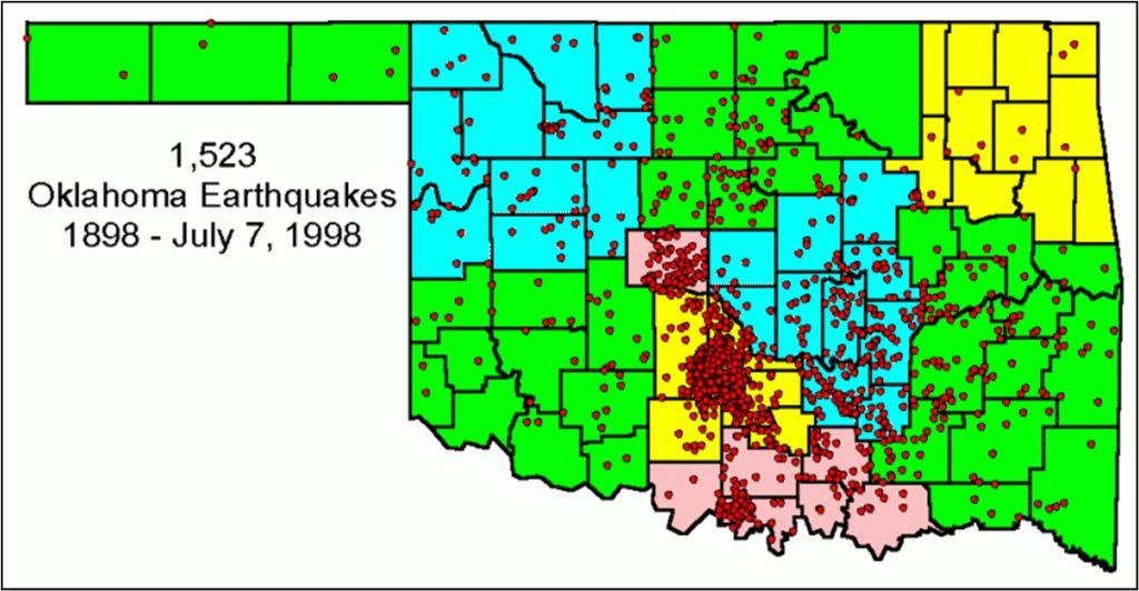
8 The Oklahoma Geological Survey reports a total of 6 earthquakes for Tulsa County from 1977 through 2005 Earthquakes
9 Earthquake Information All these quakes were smaller than 3.5 and produced no recorded damage Earthquakes
10 FEMA HAZUS-US Earthquake Scenario Results The largest magnitude earthquake to hit Oklahoma was a 5.7 Richter event centered near El Reno April 9, In a GIS environment the 5.7 Richter scale event was simulated on that historical point using FEMA-HAZUS-US software. 0 structures in would be impacted in any way by the results of this scenario, nor would any critical infrastructure be impacted in any negative fashion. Earthquakes
11 FEMA HAZUS-US Earthquake Scenario Results No fire stations or police stations would be operating at less than 50% capacity due to structural damages. No EOC would be adversely impacted by such an event. 2 a.m. is considered the peak residential load time. 0 injuries estimated will not require hospitalization, 0 injuries would require hospitalization and 0 deaths are estimated from this event. 0 people would seek temporary shelter from this event. Total economic loss is predicted to be $0 for such an event. Earthquakes
12 Measures 2004 Plan There were no chosen Earthquake Measures in 2004, other than building reinforcement for tornadoes and high winds ( Fortified Home ), which also protects against potential earthquake damage Fortified Home is a program of the Institute for Business & Home Safety (IBHS) Earthquakes
13 Goals & Objectives GOAL: To reduce injuries, loss of life, and damage to property, equipment and infrastructure caused by Earthquakes. 1. Public Information & Education. Improve public awareness of Earthquake hazards and measures by which people can protect themselves, their property and their community. 2. Preventive Measures. Identify and protect populations, structures, and critical infrastructure particularly vulnerable to Earthquakes, with consideration for uncalculated benefits such as averting environmental and business losses. Earthquakes
14 Goals & Objectives (cont.) GOAL: To reduce injuries, loss of life, and damage to property, equipment and infrastructure caused by Earthquakes. 3. Structural Projects. Provide for necessary construction, renovation, retrofitting or refurbishment to protect vulnerable structures from the effects of earthquakes. 4. Property Protection. Implement building materials and techniques in retrofitting or in new construction to minimize the risk to public properties and their occupants caused by Earthquakes. Earthquakes
15 Goals & Objectives (cont.) GOAL: To reduce injuries, loss of life, and damage to property, equipment and infrastructure caused by Earthquakes. 5. Emergency Services. Establish or expand emergency services protocols that adequately address Earthquake response. 6. Natural Resource Protection. Take advantage of opportunities for programs and policies that reduce negative environmental impacts. Examples include sustainable programs for debris management and recycling, and fortified construction with environmentally friendly materials. Earthquakes
16 Potential mitigation measures What are some additional measures we may adopt in 2009? Earthquakes
17 Potential additional Earthquake Public Information & Education Educate the public and builders to the fact that construction techniques for mitigating tornado damage also mitigate damage from minor earthquakes. Public Information & Education Provide information to the public on earthquake damage riders to their homeowner s s insurance. Earthquakes
18 Potential additional Earthquake (cont.) Property Protection Building reinforcements against wind and tornado damage will also protect against the minor earthquakes projected for the area. Emergency Services Develop a Debris Management plan which will assist in multiple types of hazards, including earthquake damage. Earthquakes
 Structural Load Paths www.disastersafety.")
19 Fortified Home Institute for Business & Home Safety (IBHS) Structural Load Paths Earthquakes

20 Fortified Home Institute for Business & Home Safety (IBHS) Connection To Foundation, Slab On Grade Anchor Bolts Earthquakes
 Wall To Foundation www.disastersafety.")
21 Fortified Home Institute for Business & Home Safety (IBHS) Wall To Foundation Earthquakes
 www.disastersafety.")
22 Fortified Home Institute for Business & Home Safety (IBHS) Earthquakes
")

23 Fortified Home Institute for Business & Home Safety (IBHS) Connectors for roof system Earthquakes

24 Expansive Soils
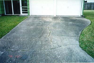
25 Expansive Soils Introduction Soils and soft rock that swell or shrink due to changes in moisture content are known as Expansive Soils. Expansive soil is often referred to as swelling clay. Clay attracts and absorbs water. Dry clay will increase in volume as water is absorbed and decrease as it dries. Many factors control how much soil can swell, including type and concentration of minerals, density, amount of moisture change and restraining pressure of surrounding soil. The swell potential of soils beneath any particular property depends on local geology. The following maps were generated in a GIS environment using USDA Soil data viewer & its SSURGO (Soil Survey Geographic) Database. Expansive Soils


26 Expansive Soils in Action Soil sample with moderate shrink/swell potential Soil sample after the addition of a small amount of water Soil sample 48 hours later Expansive Soils

27 Oklahoma s s months of heavy rain followed by extended dry spells leads to an increased hazard from expansive soil damage Expansive Soils

28 Expansive Soils
29 Expansive Soils Source: National Resource Conservation Service (NRCS) Expansion Potential Very High Area (mi²) 2.9 Area (%) 11.4 High Moderate Low Water Expansive Soils

30 Expansive Soils Expansive Soils
31 6 Critical Facilities with Very High Expansive Soils Facility Name Bank of Oklahoma Bank of the West Fire Station #2 IBC Bank Address Warren Clinic (S. Memorial) YMCA Daycare Wilson Building Expansive Soils
32 4 Critical Facilities with High / Moderate Expansive Soils Facility Name Liberty Public School Midwest Childcare 8 Acres Camp Daycare Sand Plum Retirement Address High High Moderate Moderate Expansive Soils
33 Expansive Soils Future Growth Areas Expansion Potential Very High Area (mi²) 2.9 Area (%) 6.2% High Moderate % 32.73% Low % Water % Expansive Soils
34 Measures 2004 Plan Where do we stand on them? Develop and implement a public information strategy for informing citizens and the building industry of the dangers and costs to buildings of expansive soils. Identify and repair Critical Facilities that show or have expansive soils-related damage. Expansive Soils
35 Measures 2004 Plan Where do we stand on them? Investigate codes/incentives for the construction of new foundations i.e., pre-stressed, post-stressed, stressed, piered to avoid expansive soil problems. Expansive Soils
36 Goals & Objectives GOAL: To reduce the damage and economic losses caused by expansive soils on property and infrastructure. 1. Public Information & Education. Improve public awareness of expansive-soil soil hazards, with both general & site-specific specific information, & provide knowledge about available measures by which people can protect their property & their community. 2. Preventive Measures. Avoid expansive-soils soils locations, when possible. Explore options for loss-mitigation from expansive soils, including building codes & code-plus options. Examine soils before building critical facilities & infrastructure. Expansive Soils
37 Goals & Objectives (cont.) GOAL: To reduce the damage and economic losses caused by expansive soils on property and infrastructure. 3. Structural Projects. Identify and implement measures to reduce or avert expansive-soils soils damages and losses to structures and infrastructure, with emphasis on critical facilities and utilities. 4. Property Protection. Identify and protect resources and critical infrastructures that are vulnerable to expansive soils. Expansive Soils
38 Goals & Objectives (cont.) GOAL: To reduce the damage and economic losses caused by expansive soils on property and infrastructure. 5. Emergency Services. Survey emergency and critical facilities for potential expansive soil problems; repair and retrofit as needed; and consider soils when building emergency facilities. 6. Natural Resource Protection. Protect and enhance natural resources by adopting and implementing sustainable expansive soils policies that have few or no negative impacts and have positive environmental effects when possible. Expansive Soils
39 Potential mitigation measures Which 2004 measures do we keep? What are some additional measures we may adopt in 2009? Expansive Soils
40 Potential additional Expansive Soils Public Information & Education Inform homeowners of landscaping measures, such as xeriscaping, drainage systems or ground sloping, that can mitigate foundation damage Preventive Measures Establish a procedure to inform builders when they apply for permits to check for expansive soils Expansive Soils
41 Potential additional Expansive Soils (cont.) Preventive Measures Educate builders on appropriate foundation types for soils with different degrees of shrink-swell swell potential. For example, using post-tensioned tensioned slab-on on-grade or drilled pier vs. standard slab on grade or wall on grade foundations. Expansive Soils


42 Educate local builders, homeowners, and homebuyers on appropriate building techniques for expansive soils Expansive Soils
43 Vulnerability Analysis Type of Occurrence History Prob Hum Impact Prop Infra Bus Mit n Activities Resources Int. Ext. Total Dam/Levee Drought Earthquake Expansive Soils Flooding Hail HazMat, Fixed Heat High Wind Lightning Tornadoes Transportation Urban Fires Wildfires Winter Storm


44
45 Questions or Comments? Plan can be reviewed at:
Multi-Jurisdictional Hazard Mitigation Plan. Table C.10 The Richter Scale. Descriptor Richter Magnitude Earthquake Effects
 Geologic Hazards Earthquake Earthquakes are very rare in Pennsylvania and have caused little damage, with no reported injuries or causalities. Earthquakes that do occur in Pennsylvania happen deep within
Geologic Hazards. Montour County Multi-jurisdictional. General. Earthquake
 Geologic Hazards General s are very rare in Pennsylvania and have caused little damage with no reported injuries or causalities. s that do occur in Pennsylvania happen deep within the Earth s crust. This
2014 Annual Mitigation Plan Review Meeting
 2014 Annual Mitigation Plan Review Meeting Highland County EMA MEETING OBJECTIVES Understand Your Natural Disaster Risk Review of Previous Plans Current Plan Status Future Activity Plan/Needs of Each Community
5.2 IDENTIFICATION OF HAZARDS OF CONCERN
 5.2 IDENTIFICATION OF HAZARDS OF CONCERN 2016 HMP Update Changes The 2011 HMP hazard identification was presented in Section 3. For the 2016 HMP update, the hazard identification is presented in subsection
4.1 Hazard Identification: Natural Hazards
 data is provided in an annex, it should be assumed that the risk and potential impacts to the affected jurisdiction are similar to those described here for the entire Sacramento County Planning Area. This
Table G - 6. Mitigation Actions Identified for Implementation by the City of Kent ( ) (From Wilkin County Master Mitigation Action Chart)
 (From Wilkin County Master Mitigation Action Chart)") Table G - 6. Actions Identified by the () (From Master Action Chart) Multi-Hazard Plan, 2017 Action Comments 5 All-Hazards Local Planning & Regulations Update the Operations Plan on an annual basis. Work
Table G - 6. Actions Identified by the () (From Master Action Chart) Multi-Hazard Plan, 2017 Action Comments 5 All-Hazards Local Planning & Regulations Update the Operations Plan on an annual basis. Work
2014 Russell County Hazard Mitigation Plan Update STAKEHOLDERS AND TECHNICAL ADVISORS MEETING 2/6/14
 2014 Russell County Hazard Mitigation Plan Update STAKEHOLDERS AND TECHNICAL ADVISORS MEETING 2/6/14 Welcome and Introductions We cannot direct the wind, but we can adjust our sails. 44 CFR 201.6; Local
HAZUS-MH: Earthquake Event Report
 HAZUS-MH: Earthquake Event Report Region Name: El Paso County Earthquake Scenario: El Paso County Random EQ Print Date: February 08, 2006 Disclaimer: The estimates of social and economic impacts contained
5.2 IDENTIFICATION OF HAZARDS OF CONCERN
 5.2 IDENTIFICATION OF HAZARDS OF CONCERN 2016 HMP Update Changes The 2011 HMP hazard identification was presented in Section 3. For the 2016 HMP update, the hazard identification is presented in subsection
5.2 IDENTIFICATION OF HAZARDS OF CONCERN
 5.2 IDENTIFICATION OF HAZARDS OF CONCERN 2015 HMP Update Changes The 2010 HMP hazard identification was presented in Section 6. For the 2015 HMP update, the hazard identification is presented in subsection
The Richter Scale. Micro Less than 2.0 Microearthquakes, not felt. About 8,000/day
 Geologic Hazards General s are very rare in Pennsylvania and have caused very little damage and no reported injuries or casualties. Since the Commonwealth is not on an active fault, the earthquakes that
Southington. Challenges
 Southington Southington, similar to its next-door neighbor Berlin, is a suburban community in the southeast part of the region. Originally an agricultural community, Southington has also hosted industry
5.2. IDENTIFICATION OF NATURAL HAZARDS OF CONCERN
 5.2. IDENTIFICATION OF NATURAL HAZARDS OF CONCERN To provide a strong foundation for mitigation strategies considered in Sections 6 and 9, County considered a full range of natural hazards that could impact
Steps to Reduce the Risk of Tornado Damage in Commercial Structures
 Hanover Risk Solutions Steps to Reduce the Risk of Tornado Damage in Commercial Structures About 1,000 tornadoes occur each year in the United States, causing an average of $1.1 billion in property damage
Assumption Parish Hazard Mitigation Plan Update Public Meeting. September 1, 2015 Napoleonville, LA
 Assumption Parish Hazard Mitigation Plan Update Public Meeting September 1, 2015 Napoleonville, LA Agenda Hazard Mitigation Planning Process SDMI Staff Risk Assessment SDMI Staff Update on Previous/Current
Baldwin County, Alabama
 2015 Baldwin County, Alabama Multi-Hazard Mitigation Plan I. Comprehensive Plan A multi-jurisdiction plan City of Bay Minette City of Daphne Town of Elberta City of Fairhope City of Foley City of Gulf
West Carroll Parish Hazard Mitigation Plan Update Public Meeting. August 25, 2015 Oak Grove, LA
 West Carroll Parish Hazard Mitigation Plan Update Public Meeting August 25, 2015 Oak Grove, LA Agenda Hazard Mitigation Planning Process SDMI Staff Risk Assessment SDMI Staff Update on Previous/Current
CITY OF VESTAVIA HILLS
 CITY OF VESTAVIA HILLS FLOODPLAIN MANAGEMENT PLAN FMPC Meeting #3 September 29, 2015 ORGANIZATION OF 2015 FMP 2015 Floodplain Management Plan Structure Chapter 1 Introduction Chapter 2 Community Profile
CHAPTER 7 EXPANSIVE SOIL
 CHAPTER 7 EXPANSIVE SOIL Expansive soils are soils that expand when water is added, and shrink when they dry out. This continuous change in soil volume can cause homes built on this soil to move unevenly
On Page 1, following Paragraph 2 of the Planning Participants subsection, insert the following: 2012 Committee members included:
 Appendix 4: City of West Linn Addendum to the Clackamas County Natural Hazards Mitigation Plan 2012 Amendments and Update The Oregon Partnership for Disaster Resilience prepared this Appendix to the City
Timeframe. Crow Wing County, Baxter, Brainerd, Breezy Point, Crosby, Crosslake, Cuyuna, Deerwood, Emily, Fifty
 Table G - 13. s Identified for by the () (From Crow Wing County Master Chart) 1 5 9 All- Hazards All- Hazards Winter Work to ensure that all Crow Wing County residents are aware of and sign-up for the
5.2 IDENTIFICATION OF NATURAL HAZARDS OF CONCERN
 5.2 IDENTIFICATION OF NATURAL HAZARDS OF CONCERN To provide a strong foundation for mitigation strategies considered in Sections 6 and 9, County considered a full range of natural s that could impact area,
Page G Crow Wing County Multi-Hazard Mitigation Plan, 2017
 Table G - 10. s Identified by the () (From Crow Wing County Master Chart) 1 5 All- Hazards All- Hazards Work to ensure that all Crow Wing County residents are aware of and sign-up for the County s Emergency
IDENTIFICATION OF HAZARDS OF CONCERN
 IDENTIFICATION OF HAZARDS OF CONCERN To provide a strong foundation for mitigation strategies considered in Section 6, the Village considered a full range of hazards that could impact the area and then
APPLICATIONS OF EARTHQUAKE HAZARD MAPS TO LAND-USE AND EMERGENCY PLANNING EXAMPLES FROM THE PORTLAND AREA
 APPLICATIONS OF EARTHQUAKE HAZARD MAPS TO LAND-USE AND EMERGENCY PLANNING EXAMPLES FROM THE PORTLAND AREA O. Gerald Uba Metro, Portland, Oregon OVERVIEW The extent to which we understand "below ground"
Bossier Parish Hazard Mitigation Plan Update Public Meeting. August 10, 2016 Bossier City, LA
 Bossier Parish Hazard Mitigation Plan Update Public Meeting August 10, 2016 Bossier City, LA Agenda Hazard Mitigation Planning Process SDMI Staff Risk Assessment SDMI Staff Update on Previous/Current Mitigation
RISK ASSESSMENT COMMUNITY PROFILE NATURAL HAZARDS COMMUNITY RISK PROFILES. Page 13 of 524
 RISK ASSESSMENT COMMUNITY PROFILE NATURAL HAZARDS COMMUNITY RISK PROFILES Page 13 of 524 Introduction The Risk Assessment identifies and characterizes Tillamook County s natural hazards and describes how
9. GEOLOGY, SOILS, AND MINERALS
 June 28, 2018 Page 9-1 9. GEOLOGY, SOILS, AND MINERALS This EIR chapter describes the existing geological, soil, and mineral conditions in the planning area. The chapter includes the regulatory framework
Tornado Preparedness. Monthly Safety Meeting
 Tornado Preparedness Monthly Safety Meeting Introduction Tornadoes can occur anywhere and at any time during the year. In an average year, 800 tornadoes are reported throughout the nation. The most violent
Tornado Safety: 2013 Practical Steps for Weather-Related Emergencies
 Tornado Safety: 2013 Practical Steps for Weather-Related Emergencies Campbell County Public Safety One County, One Mission, One Call Away Tornado Preparedness Day March 12, 2013 As 62 tornadoes struck
City of Manitou Springs
 March 2018 City of Manitou Springs Implementing Land Use tools to reduce and mitigate natural hazard risk Context & History Past Present Historic homes Older infrastructure Hillside development Creekside
Severe Thunderstorms
 Severe Thunderstorms Severe Thunderstorms Explain that, while all thunderstorms are dangerous, the National Weather Service (NWS) defines a severe thunderstorm as one that: Display Slide Th-0 Produces
DOWNLOAD OR READ : GIS BASED FLOOD LOSS ESTIMATION MODELING IN JAPAN PDF EBOOK EPUB MOBI
 DOWNLOAD OR READ : GIS BASED FLOOD LOSS ESTIMATION MODELING IN JAPAN PDF EBOOK EPUB MOBI Page 1 Page 2 gis based flood loss estimation modeling in japan gis based flood loss pdf gis based flood loss estimation
Advisory Committee Meeting December 5, 2012
 SOUTH CENTRAL REGION MULTI-JURISDICTION HAZARD MITIGATION PLAN Advisory Committee Meeting December 5, 2012 MEETING PURPOSE Review Municipality Meetings and Capabilities Review Hazard Identification and
The Size of an Earthquake. Intensity of Shaking (Robert Mallet, 1857) Calculation of Earthquake Magnitude (Charles Richter, 1935)
 Calculation of Earthquake Magnitude (Charles Richter, 1935)") The Size of an Earthquake Intensity of Shaking (Robert Mallet, 1857) Calculation of Earthquake Magnitude (Charles Richter, 1935) In 1857, Robert Mallet produced isoseismal lines based on quantified damage
The Size of an Earthquake Intensity of Shaking (Robert Mallet, 1857) Calculation of Earthquake Magnitude (Charles Richter, 1935) In 1857, Robert Mallet produced isoseismal lines based on quantified damage
Tornadoes pose a high risk because the low atmospheric pressure, combined with high wind velocity, can:
 Tornadoes are powerful, circular windstorms that may be accompanied by winds in excess of 200 miles per hour. Tornadoes typically develop during severe thunderstorms and may range in width from several
3.1: Identifying Hazards. Introduction
 3.1: Identifying Hazards 44 CFR 201.4(c)(5)(i)(ii) The State mitigation strategy shall include the following elements: A Plan Maintenance Process that includes: An established method and schedule for monitoring,
While all thunderstorms are dangerous, the National Weather Service (NWS) defines a severe thunderstorm as one that:
 defines a severe thunderstorm as one that:") While all thunderstorms are dangerous, the National Weather Service (NWS) defines a severe thunderstorm as one that: Produces hail at least three-quarters of an inch in diameter. Has winds of 58 miles
While all thunderstorms are dangerous, the National Weather Service (NWS) defines a severe thunderstorm as one that: Produces hail at least three-quarters of an inch in diameter. Has winds of 58 miles
Tornadoes. Tornadoes COMMUNITY EMERGENCY RESPONSE TEAM TORNADOES
 Tornadoes Tornadoes Tell the participants that tornadoes are powerful, circular windstorms that may be accompanied by winds in excess of 200 miles per hour. Tornadoes typically develop during severe thunderstorms
STEUBEN COUNTY, NEW YORK. Hazard Analysis Report
 STEUBEN COUNTY, NEW YORK Hazard Analysis Report Prepared by: April 1, 2014 Background On April 1, 2014 the Steuben County Office of Emergency Management conducted a hazard analysis using the automated
Earthquakes. Copyright 2006 InstructorWeb
 Earthquakes Earthquakes cause the earth to shake! Earthquakes are caused by a fault line under the earth's crust. You do not have to be right under a fault line to feel an earthquake. You could be miles
Daily Operations Briefing Wednesday, April 5, :30 a.m. EDT
 Daily Operations Briefing Wednesday, April 5, 2017 8:30 a.m. EDT Significant Activity Apr 4-5 Significant Events: Severe Weather Southern Plains to Southeast Significant Weather: Severe thunderstorms &
TORNADOES. DISPLAY VISUAL A Tornado Is... Tornadoes can: Rip trees apart. Destroy buildings. Uproot structures and objects.
 TORNADOES Introduce tornadoes by explaining what a tornado is. DISPLAY VISUAL A Tornado Is... A powerful, circular windstorm that may be accompanied by winds in excess of 250 miles per hour. Tell the participants
Pacific Catastrophe Risk Assessment And Financing Initiative
 Pacific Catastrophe Risk Assessment And Financing Initiative VANUATU September 211 Country Risk Profile: VANUATU is expected to incur, on average, 48 million USD per year in losses due to earthquakes and
West Baton Rouge Parish Hazard Mitigation Plan Update Public Meeting. September 9, 2015 Port Allen, LA
 West Baton Rouge Parish Hazard Mitigation Plan Update Public Meeting September 9, 2015 Port Allen, LA Agenda Hazard Mitigation Planning Process SDMI Staff Risk Assessment SDMI Staff Update on Previous/Current
COMMUNITY EMERGENCY RESPONSE TEAM TORNADOES
 Tornadoes are powerful, circular windstorms that may be accompanied by winds in excess of 200 miles per hour. Tornadoes typically develop during severe thunderstorms and may range in width from several
CHAPTER GEOLOGICALLY HAZARDOUS AREAS Applicability Regulations.
 CHAPTER 19.07 GEOLOGICALLY HAZARDOUS AREAS 19.07.010 Applicability. Geologically hazardous areas may pose a threat to the health and safety of citizens when incompatible development is sited in areas of
5.2 IDENTIFICATION OF HAZARDS OF CONCERN
 5.2 IDENTIFICATION OF HAZARDS OF CONCERN To provide a strong foundation for mitigation actions considered in Sections 6 and 9, County focused on considering a full range of s that could impact area, and
CITY OF RIVERSIDE USING HAZUS TO CREATE A EARTHQUAKE PLANNING GUIDE FOR A UNIFIED FIELD RESPONSE
 CITY OF RIVERSIDE USING HAZUS TO CREATE A EARTHQUAKE PLANNING GUIDE FOR A UNIFIED FIELD RESPONSE Presented by the Phil McCormick City of Riverside Office of Emergency Management HISTORY The City had several
Pacific Catastrophe Risk Assessment And Financing Initiative
 Pacific Catastrophe Risk Assessment And Financing Initiative TUVALU is expected to incur, on average,. million USD per year in losses due to earthquakes and tropical cyclones. In the next 5 years, has
Daily Operations Briefing. Saturday, March 17, :30 a.m. EDT
 Daily Operations Briefing Saturday, March 17, 2018 8:30 a.m. EDT Significant Activity Mar 16-17 Significant Events: None Tropical Activity: Western Pacific No activity affecting U.S. interests Significant
Miami-Dade County Overview
 Miami-Dade County Overview 2,000 square miles World s busiest cruise port 2.6 million residents Second busiest US airport for international travelers Gateway to the Caribbean and Latin America Natural
Initiative. Country Risk Profile: papua new guinea. Better Risk Information for Smarter Investments PAPUA NEW GUINEA.
 Pacific Catastrophe Risk Assessment And Financing Initiative PAPUA NEW GUINEA September 211 Country Risk Profile: papua new is expected to incur, on average, 85 million USD per year in losses due to earthquakes
IMPERIAL COUNTY PLANNING AND DEVELOPMENT
 IMPERIAL COUNTY PLANNING AND DEVELOPMENT GEODATABASE USER MANUAL FOR COUNTY BUSINESS DEVELOPMENT GIS June 2010 Prepared for: Prepared by: County of Imperial Planning and Development 801 Main Street El
United States Multi-Hazard Early Warning System
 United States Multi-Hazard Early Warning System Saving Lives Through Partnership Lynn Maximuk National Weather Service Director, Central Region Kansas City, Missouri America s s Weather Enterprise: Protecting
SEISMIC RISK ASSESSMENT IN ARMENIA
 SEISMIC RISK ASSESSMENT IN ARMENIA Hovhannes Khangeldyan Head of National Crisis Management Center Rescue Service Ministry of Emergency Situations of the Republic of Armenia Tokyo, 2016 ARMENIA: GEOGRAPHICAL
WHAT HAPPENS WHEN A TORNADO STRIKES THE COMMUNITY? Carroll County Sheriff s Office Emergency Management
 WHAT HAPPENS WHEN A TORNADO STRIKES THE COMMUNITY? Carroll County Sheriff s Office Emergency Management WHAT IS EMERGENCY MANAGEMENT? Carroll County Sheriff s Office Emergency Management Agency is responsible
The UN-GGIM: Europe core data initiative to encourage Geographic information supporting Sustainable Development Goals Dominique Laurent, France
 INSPIRE conference Strasbourg 6 September 2017 The UN-GGIM: Europe core data initiative to encourage Geographic information supporting Sustainable Development Goals Dominique Laurent, France Introduction
Kentucky Weather Hazards: What is Your Risk?
 Kentucky Weather Hazards: What is Your Risk? Stuart A. Foster State Climatologist for Kentucky 2010 Kentucky Weather Conference Bowling Green, Kentucky January 16, 2010 Perspectives on Kentucky s Climate
Interpretive Map Series 24
 Oregon Department of Geology and Mineral Industries Interpretive Map Series 24 Geologic Hazards, and Hazard Maps, and Future Damage Estimates for Six Counties in the Mid/Southern Willamette Valley Including
Geographic Information Systems
 Geographic Information Systems What is a Geographic Information System (GIS)? definition of GIS - An internally referenced, automated, spatial information system for data mapping, management, and analysis
Winter Storms December 2, 2009
 Winter Storms December 2, 2009 Plan Update Flanagan & Associates, LLC Consultants Tulsa, OK www.rdflanagan.com rdflanagan@rdflanagan.com Plan can be reviewed at: www.rdflanagan.com/canadiancounty.html
COMMUNITY PREPAREDNESS
 THE PULSE COMMUNITY PREPAREDNESS Checking our pulse is essential in monitoring our Vital Signs. The Pulse highlights a specific indicator of human well-being that is contained in United Way of Central
Running Head: HAZARD MITIGATION PLAN OUTLINE FOR MISSISSIPPI 1
 Running Head: HAZARD MITIGATION PLAN OUTLINE FOR MISSISSIPPI 1 Hazard Mitigation Plan Outline for Mississippi Name: Institution: HAZARD MITIGATION PLAN OUTLINE FOR MISSISSIPPI 2 Hazard Mitigation Plan
Bridge Risk Modeling
 time good Bridge Risk Modeling Current Florida DOT Research condition bad Paul D. Thompson, Consultant Background Research team Florida State University John Sobanjo (PI) Paul D. Thompson (co-pi) Florida
Coastal Resiliency: Planning for Natural Variability and Recovering from Extreme Events
 Coastal Resiliency: Planning for Natural Variability and Recovering from Extreme Events Stephanie Showalter, J.D., M.S.E.L. Director, National Sea Grant Law Center University of Mississippi Coastal Hazards
Seismic Hazard Abatement Program
 Seismic Hazard Abatement Program Recommendations To take the first steps toward a seismic mitigation program for older existing buildings To improve our current regulatory system for implementation of
May 31, Flood Response Overview
 May 31, 2013 Flood Response Overview Suppression 867 Personnel on three (3) shifts 289 Red Shift (A) 289 Blue Shift (B) 289 Green Shift (C) Department Overview Department Overview EMS: 40,934 False Alarm:
Common Core Reading Passage
 Directions: Please read the following Common Core Reading passage and answer the questions that follow. Common Core Reading Passage Forecasting Severe Weather to Communities Helps Them Prepare By Alissa
Pre-Disaster Natural Hazard Mitigation Plan Guilford, Connecticut History of Hazard Mitigation Planning Authority Disaster Mitigation Act of 2000 (ame
 Pre-Disaster Natural Hazard Mitigation Plan Guilford, Connecticut History of Hazard Mitigation Planning Authority Disaster Mitigation Act of 2000 (amendments to Stafford Act of 1988) Presented by: David
KENTUCKY HAZARD MITIGATION PLAN RISK ASSESSMENT
 KENTUCKY HAZARD MITIGATION PLAN RISK ASSESSMENT Presentation Outline Development of the 2013 State Hazard Mitigation Plan Risk Assessment Determining risk assessment scale Census Data Aggregation Levels
SECTION 6 VULNERABILITY ASSESSMENT
 SECTION 6 VULNERABILITY ASSESSMENT This section identifies and quantifies the vulnerability of the MEMA District 1 Region to the significant hazards identified in the previous sections (Hazard Identification
Natural Disasters. in Florida. Severe Thunderstorms
 Natural Disasters in Florida SC.6.E.7.7 Investigate how natural disasters have affected human life in Florida. Severe Thunderstorms While the typical afternoon thunderstorm in Florida may not appear to
Hawke s Bay Liquefaction Hazard Report - Frequently Asked Questions
 Hawke s Bay Liquefaction Hazard Report - Frequently Asked Questions What is liquefaction? Liquefaction occurs when an earthquake shakes up water-logged sediments. As a result, the soil behaves like a liquid
Pacific Catastrophe Risk Assessment And Financing Initiative
 Pacific Catastrophe Risk Assessment And Financing Initiative TIMOR-LESTE September Timor-Leste is expected to incur, on average, 5.9 million USD per year in losses due to earthquakes and tropical cyclones.
Safety Issue: Types of weather emergencies and natural. Weather Emergencies
 Overview Safety Issue: Rapid and effective response to weather emergencies and other natural disasters whether during or after work hours takes forethought and careful planning. Types of weather emergencies
Hazard Vulnerability Analysis (HVA)
") Hazard Vulnerability Analysis (HVA) What is an HVA Systematic approach to recognizing hazards that may effect the ability to care for residents The risks associated with each hazard are analyzed to prioritize
Hazard Vulnerability Analysis (HVA) What is an HVA Systematic approach to recognizing hazards that may effect the ability to care for residents The risks associated with each hazard are analyzed to prioritize
IV. ENVIRONMENTAL IMPACT ANALYSIS E. GEOLOGY AND SOILS
 IV. ENVIRONMENTAL IMPACT ANALYSIS E. GEOLOGY AND SOILS The following section is a summary of the geotechnical report conducted for the Proposed Project. The Geotechnical Engineering Investigation (the
Assessing Hazards and Risk
 Page 1 of 6 EENS 204 Tulane University Natural Disasters Prof. Stephen A. Nelson Assessing Hazards and Risk This page last updated on 07-Jan-2004 As discussed before, natural disasters are produced by
Seth J. Wittke Wyoming State Geological Survey
 Seth J. Wittke Wyoming State Geological Survey Project initiation Data manipulation Scenarios Creating the IMS Lessons learned County-wide block level probabilistic models created in 2004 for state mitigation
Complete Weather Intelligence for Public Safety from DTN
 Complete Weather Intelligence for Public Safety from DTN September 2017 White Paper www.dtn.com / 1.800.610.0777 From flooding to tornados to severe winter storms, the threats to public safety from weather-related
Pacific Catastrophe Risk Assessment And Financing Initiative
 Pacific Catastrophe Risk Assessment And Financing Initiative PALAU September is expected to incur, on average,.7 million USD per year in losses due to earthquakes and tropical cyclones. In the next 5 years,
Oregon APA Legal Issues Workshop December 7, Tricia Sears, DLCD With information from Bill Burns, DOGAMI
 Oregon APA Legal Issues Workshop December 7, 2018 Tricia Sears, DLCD With information from Bill Burns, DOGAMI How this Topic Arrived WE FREQUENTLY HEAR CONCERNS ABOUT LIABILITY AND TAKINGS. Current federal
The Tampa Bay Catastrophic Plan Presentation to CFGIS Users Group FDOT District 5 Urban Offices - Orlando July 30, 2010
 The Tampa Bay Catastrophic Plan Presentation to CFGIS Users Group FDOT District 5 Urban Offices - Orlando July 30, 2010 Brady Smith Senior Planner Tampa Bay Regional Planning Council Introduction Recent
TABLE OF CONTENTS LIST OF TABLES. Page
 TABLE OF CONTENTS Page 11.0 EFFECTS OF THE ENVIRONMENT ON THE PROJECT... 11-1 11.1 Weather Conditions... 11-1 11.2 Flooding... 11-2 11.3 Forest Fires... 11-2 11.4 Permafrost and Subsidence Risk... 11-3
Downtown Anchorage Seismic Risk Assessment & Land Use Regulations to Mitigate Seismic Risk
 Prepared for: The Municipality of Anchorage Planning Department and the Geotechnical Advisory Commission Downtown Anchorage Seismic Risk Assessment & Land Use Regulations to Mitigate Seismic Risk Prepared
LAND USE PLANNING AND RISK: LESSONS FROM THREE AUSTRALIAN PORT CITIES
 LAND USE PLANNING AND RISK: LESSONS FROM THREE AUSTRALIAN PORT CITIES Ken Granger Disaster Risk Scientist Slide No. 1 Land use planning is the single most important mitigation measure for limiting future
Local Area Key Issues Paper No. 13: Southern Hinterland townships growth opportunities
 Draft Sunshine Coast Planning Scheme Review of Submissions Local Area Key Issues Paper No. 13: Southern Hinterland townships growth opportunities Key Issue: Growth opportunities for Southern Hinterland
Best Practices Natural Disasters Action Plan
 Best Practices Natural Disasters Action Plan MODERATORS: Jeannie Chiaromonte, CAR Vice President / National Remarketing Manager Bank of America Chuck Novince, CAR Vice President National Accounts Manheim
4.4 Assessing Vulnerability: Estimating Potential Losses
 4.4 Assessing Vulnerability: Estimating Potential Losses This section presents exposure, damage, and loss estimates, for each of the 8 hazards evaluated. The findings support planning efforts based on
Surviving the Big One: Understanding and Preparing for a Major Earthquake in Western Oregon
 Surviving the Big One: Understanding and Preparing for a Major Earthquake in Western Oregon May 21, 2013 City of Salem Salem Public Library Althea Rizzo, Geological Hazards Program Coordinator Oregon Emergency
SECTION IV ASSESSING VULNERABILITY AND RISK
 SECTION IV ASSESSING VULNERABILITY AND RISK Describing vulnerability in terms of potential dollar loss provides the local government, the State and the federal government with a common framework with which
earthquakes 1. Earthquakes occur when plates grind against one another along cracks called faults.
 earthquakes BEGIN 1 earthquakes 1. Earthquakes occur when plates grind against one another along cracks called faults. 2 earthquakes 1. Earthquakes occur when plates grind against one another along cracks
Borah Peak Earthquake HAZUS Scenario Project Executive Summary Idaho Bureau of Homeland Security Idaho Geological Survey Western States Seismic
 Borah Peak Earthquake HAZUS Scenario Project Executive Summary Idaho Bureau of Homeland Security Idaho Geological Survey Western States Seismic Policy Council 12/30/2008 The HAZUS-MH analysis of the Borah
APPENDIX D REGION 5 ALL HAZARD MITIGATION PLAN EDITION PIERCE COUNTY OVERVIEW. Inherent Errors
 APPENDIX D REGION 5 ALL HAZARD MITIGATION PLAN 2015-2020 EDITION PIERCE COUNTY OVERVIEW This appendix contains the spatial results from the Hazus Earthquake Scenario results showing the Essential Facilities
Disaster Risk Assessment: Opportunities for GIS and data management with Open DRI
 Disaster Risk Assessment: Opportunities for GIS and data management with Open DRI Jacob Opadeyi Department of Geomatics Engineering and Land Management, The University of the West Indies, St. Augustine,
Tornadoes Module 2. - Tornado Watch -
 1 2 - Tornado Watch - Issued by the National Weather Service when tornadoes are possible in an area Remain alert for approaching storms Remind family/employees of location of safest places Listen to the
Table-Top Exercise for Emergency Preparedness Evaluation: Little Anse, Isle Madame
 Table-Top Exercise for Emergency Preparedness Evaluation: Little Anse, Isle Madame Alexander Chung, M.Sc. Candidate C-Change Student Research Associate May 2013 The Community of Little Anse Coastal community
Business Continuity Planning (BCP)
") Business Continuity Planning (BCP) Eric Holdeman, Principal Why Have a Business Continuity Plan? } Bad things happen unexpectedly and pre-event planning is part of disaster preparedness } Your community
Business Continuity Planning (BCP) Eric Holdeman, Principal Why Have a Business Continuity Plan? } Bad things happen unexpectedly and pre-event planning is part of disaster preparedness } Your community
HAZARD DESCRIPTION... 1 LOCATION... 1 EXTENT... 1 HISTORICAL OCCURRENCES...
 WINTER STORM HAZARD DESCRIPTION... 1 LOCATION... 1 EXTENT... 1 HISTORICAL OCCURRENCES... 3 SIGNIFICANT PAST EVENTS... 4 PROBABILITY OF FUTURE EVENTS... 5 VULNERABILITY AND IMPACT... 5 Hazard Description