Earthquake Engineering GE / CE - 479/679
|
|
|
- Geraldine Norman
- 5 years ago
- Views:
Transcription
1 Earthquake Engineering GE / CE - 479/679 Topic 4. Seismometry John G. Anderson Director February 4-6,
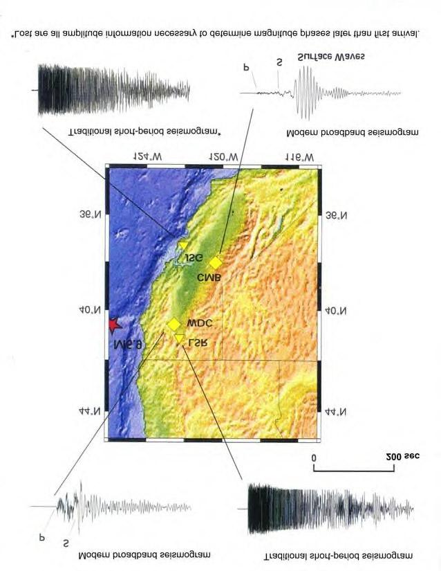
2 Wood-Anderson Seismograph Important because: Principles of operation are widely used. Basis for the magnitude scales of earthquakes that are still used today. Provide data for early southern California earthquake catalog that is still used today. February 4-6,
3 3
4 4
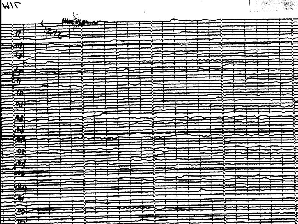
5 Sample seismogram from a WA Original February 4-6, vnta9201
6 Magnitude M L C. F. Richter was the first person to define the magnitude of an earthquake. The magnitude was defined from measurements taken using a Wood- Anderson seismogram. All subsequent magnitude scales are defined using the same principle. February 4-6,
7 Magnitude: General Comment Most magnitude scales, like M L, are tied to a certain kind of seismic instrument. Important issue: convenience of determining the magnitude from the seismograms. February 4-6,
8 8
9 This table, from the textbook Elementary Seismology by Richter (1958), gives the distance correction for the local magnitude. This shows that you need the amplitude and the distance to the earthquake to determine the magnitude. February 4-6,
10 Sample magnitude calculation February 4-6, vnta9201
11 Sample magnitude calculation P-wave - t~1.0 s February 4-6, vnta9201
12 Sample magnitude calculation P-wave t~1.0 s S-wave - t~6.0 s February 4-6, vnta9201
13 Sample magnitude calculation P-wave tp~1.0 s S-wave - ts~6.0 s ts-tp = (6-1) s = 5 s R~(ts-tp) * 8 km/s ~ 40 km February 4-6, vnta9201
14 Sample magnitude calculation R~40 km Peak response = 828 mm ML=log A - log A 0 log A 0 (40 km) = -2.4 ML=log(828)+2.4 ML= = 5.3 February 4-6, vnta9201
15 15
16 16
17 SMA-1 Strong Motion Important because: Accelerograph Strong motion data is the basis for all quantitative earthquake resistant design. Most of the early strong motion data is recorded on instruments of this type or with a similar design. Principles of operation similar to Wood Anderson February 4-6,
18 18
19 19
20 20 Is there a magnitude scale associated with the strong motion accelerograph? Traditionally, NO. You cannot determine the magnitude of an earthquake by reading the peak acceleration and knowing the distance. YES, in the sense that you can calculate the synthetic Wood-Anderson response easily from a digital accelerogram. ML is thus the scale most conveniently used with the accelerograph. (Above examples are done this way.)
21 21 Digital Accelerograph
22 22
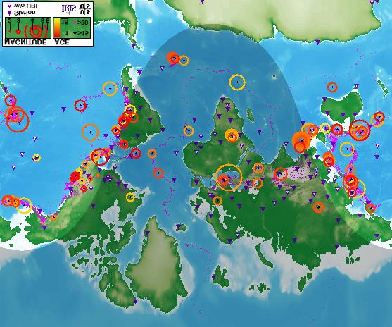
23 23
24 24
25 More Sensitive Seismometers Uses Teleseismic earthquake observations Global picture of earthquake activity Basis for Ms and mb magnitude scales Observe microearthquakes on a regional basis February 4-6,
26 Some Definitions (not standard) Teleseismic - distant seismic - >30 o Some might use a smaller distance, as little as 15 o or 20 o. Regional km (5 o ) to 30 o Local - Closer than 500 km. Some might say closer than 100 km. February 4-6,
27 27
28 28
29 MS is determined from the peak of the long period surface waves observed on a long-period seismograph. mb is determined from the peak of the P-wave on a short-period seismograph. These are defined for teleseismic observations. February 4-6,
30 Global Seismic Network Where? Magnitude scales? February 4-6,
31 31
32 32
33 33
34 34
35 35
36 36
37 37
38 38

39 39 Isabella

40 40 Isabella

41 41 Mammoth Lakes

42 Mammoth Lakes (MLAC) 42
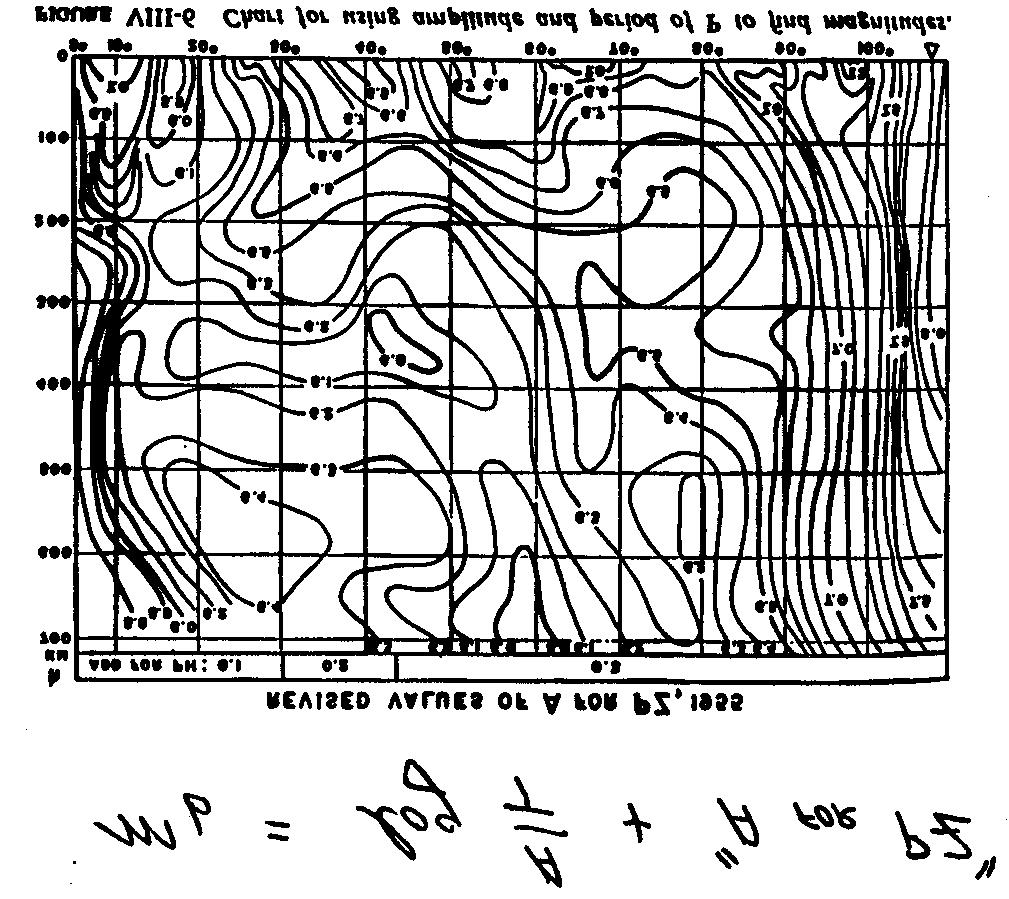
43 43
44 44
45 45
46 46
47 47
48 48
49 I should replace these seismograms with some more recent records February 4-6,
50 At large distances, seismologists use travel time tables or curves, such as these. The scale goes all the way from zero distance to half way around the world on this chart (20 0 intervals). The time goes from zero to 50 minutes, in 5 minute intervals. Because the Earth is layered, there are more waves than just the P- and S- waves on this chart. February 4-6,
51 51
52 52
53 53
54 54
55 55
56 Role of the global networks Large-scale picture of the global seismicity. February 4-6,
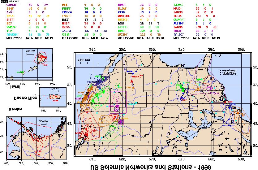
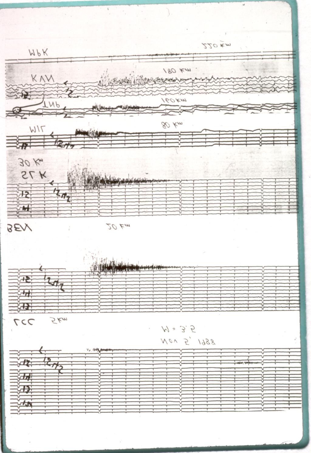
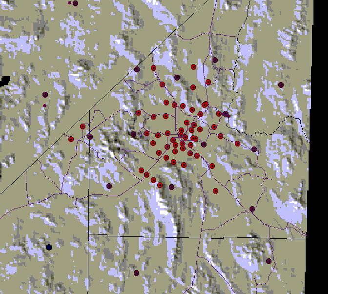
57 57
58 58
59 59
60 60
61 61 Regional Networks
62 62

63 6 February 4-6,
64 Microwave network operated by the Seismological Laboratory to transmit seismic data to Reno. February 4-6,
65 65
66 66
67 67
68 How to estimate the distance? Use the relative speed of the P- and the S-waves. This shows the simple math behind the process. This is the origin of the rule of thumb used by seismologists for local earthquakes: multiply the s-p time (in sec) by 8 km/s, to get the approximate distance from the station to the epicenter. February 4-6,
69 69


70 February 4-6,
71 71
72 Seismic Moment Definition of Seismic Moment M 0 =µad µ is the shear modulus of the rock A is the area of the fault on which slip takes place D is the average slip on the fault February 4-6,
73 Moment Magnitude M W =(2/3) (log M ) (exact) M W =(2/3) log M (as applied) This is the preferred magnitude scale in the seismological community. February 4-6,
74 74
75 75
76 76
77 77
78 Summary of Important Magnitude Scales M L - Local Magnitude From peak deflection of trace recorded on Wood- Anderson seismograph - usually in the S-wave. Defined for km. Developed by Richter (1932) M S - Surface Wave Magnitude From amplitude of 20 s surface waves recorded at over 2000 km (20 o ). m b - Body Wave Magnitude From amplitude of P-wave recorded from 6 o o distance. M W - Moment Magnitude m c - Coda Magnitude m blg - Lg Magnitude February 4-6,

79 ANSS: Advanced National Seismic System February 4-6,
80 ANSS: Seismic Monitoring with a Focus on Urban Hazards Earthquake emergency response Earthquake early warning Warning of volcanic eruptions Warning of tsunamis Seismic hazard assessment Earthquake engineering Seismic research Public information Education February 4-6,
81 ANSS Equipment: Upgrade February 4-6, Current Seismic Networks Weak motion monitoring systems ~1000 modern seismographs to complete the US National Seismic Network and upgrade Regional Centers. Strong motion monitoring systems 6000 new accelerographs 3000 for urban ground motion monitoring 3000 for urban structural monitoring Upgrade Network Operation Centers and Data Management and Distribution Capabilities Sufficient operating costs
82 82
83 83
84 84

85 1 February 4-6,

86 2 February 4-6,

87 3 February 4-6,
88 88
89 89
90 90
Objective: You will learn to interpret a seismogram and, using differences in seismic waves, locate the epicenter of an earthquake.
 Earth Science Dynamic Crust Name Period Finding Epicenters Lab# Introduction: Earthquakes occur when there is movement along a fault. The friction between rock masses rubbing against one another generates
Dangerous tsunami threat off U.S. West Coast
 Earthquakes Ch. 12 Dangerous tsunami threat off U.S. West Coast Earthquakes What is an Earthquake? It s the shaking and trembling of the Earth s crust due to plate movement. The plates move, rocks along
Determining the Earthquake Epicenter: Japan
 Practice Name: Hour: Determining the Earthquake Epicenter: Japan Measuring the S-P interval There are hundreds of seismic data recording stations throughout the United States and the rest of the world.
Earthquake Lab Introduction: Purpose: Method: Equipment needed: Fundamental Concepts and Key Terms:
 Earthquake Lab Introduction: Seismology is that branch of the geological sciences which is concerned with the study of earthquakes. Purpose: The purpose of this exercise is to introduce some fundamental
Magnitude Central Italy
 Magnitude 6.3 - Central Italy > at least 227 killed > 1000 injured, 10000 bldgs destroyed or damaged > occurred in central Appenines, a mountain range formed as a large accretionary wedge > Mediterranean
Earthquakes and Volcanoes
 Name Earthquakes and Volcanoes What causes earthquakes and volcanic eruptions? Before You Read Before you read the chapter, think about what you know about earthquakes and volcanoes. In the first column,
Elastic rebound theory
 Elastic rebound theory Focus epicenter - wave propagation Dip-Slip Fault - Normal Normal Fault vertical motion due to tensional stress Hanging wall moves down, relative to the footwall Opal Mountain, Mojave
A. Locate the Epicenter
 Name: Block: Earthquake Lab The goal of this portion of the lab is to learn how recording of earthquakes seismograms are used to locate earthquakes, determine their magnitudes, and to understand the sense
8 th GULF SEISMIC FORUM Seismological and Earthquake Engineering studies in the Arabian Plate region March 3-6 Muscat - Oman
 Determination of Local Magnitude for Earthquake recorded by Sultanate of Oman seismological network Abdel Hafiez H.E (1),Khalil A.E. (2), El-Hussain I. (3), Deif A. (1,3) (1): National Research Institute
Please be sure to save a copy of this activity to your computer!
 Thank you for your purchase Please be sure to save a copy of this activity to your computer! This activity is copyrighted by AIMS Education Foundation. All rights reserved. No part of this work may be
SIMULATED SEISMOGRAMS
 SIMULATED SEISMOGRAMS Great Falls, Montana I I I I I I I I I I I I I I I I I I I I I I I I I 8:03 8:04 8:05 8:06 8:07 P-wave arrival S-wave arrival Little Rock, Arkansas I I I I I I I I I I I I I I I I
Module 7: Plate Tectonics and Earth's Structure Topic 4 Content : Earthquakes Presentation Notes. Earthquakes
 Earthquakes 1 Topic 4 Content: Earthquakes Presentation Notes Earthquakes are vibrations within the Earth produced by the rapid release of energy from rocks that break under extreme stress. Earthquakes
Activity Template. Drexel-SDP GK-12 ACTIVITY. Subject Area(s): Sound Associated Unit: Associated Lesson: None
: Sound Associated Unit: Associated Lesson: None") Activity Template Subject Area(s): Sound Associated Unit: Associated Lesson: None Drexel-SDP GK-12 ACTIVITY Activity Title: Where did the earthquake begin? Grade Level: 8 (7-9) Activity Dependency: None
Activity Template Subject Area(s): Sound Associated Unit: Associated Lesson: None Drexel-SDP GK-12 ACTIVITY Activity Title: Where did the earthquake begin? Grade Level: 8 (7-9) Activity Dependency: None
The Size of an Earthquake. Intensity of Shaking (Robert Mallet, 1857) Calculation of Earthquake Magnitude (Charles Richter, 1935)
 Calculation of Earthquake Magnitude (Charles Richter, 1935)") The Size of an Earthquake Intensity of Shaking (Robert Mallet, 1857) Calculation of Earthquake Magnitude (Charles Richter, 1935) In 1857, Robert Mallet produced isoseismal lines based on quantified damage
The Size of an Earthquake Intensity of Shaking (Robert Mallet, 1857) Calculation of Earthquake Magnitude (Charles Richter, 1935) In 1857, Robert Mallet produced isoseismal lines based on quantified damage
Earthquakes How and Where Earthquakes Occur
 Earthquakes How and Where Earthquakes Occur PPT Modified from Troy HS Is there such thing as earthquake weather? Absolutely NOT!!! Geologists believe that there is no connection between weather and earthquakes.
I. Locations of Earthquakes. Announcements. Earthquakes Ch. 5. video Northridge, California earthquake, lecture on Chapter 5 Earthquakes!
 51-100-21 Environmental Geology Summer 2006 Tuesday & Thursday 6-9:20 p.m. Dr. Beyer Earthquakes Ch. 5 I. Locations of Earthquakes II. Earthquake Processes III. Effects of Earthquakes IV. Earthquake Risk
Lecture Outline Wednesday-Monday April 18 23, 2018
 Lecture Outline Wednesday-Monday April 18 23, 2018 Questions? Lecture Final Exam Lecture Section 1 Friday May 4, 8:00-10:00am Lecture Section 2 Friday May 4, 3:10-5:10 pm Final Exam is 70% new material
Section 19.1: Forces Within Earth Section 19.2: Seismic Waves and Earth s Interior Section 19.3: Measuring and Locating.
 CH Earthquakes Section 19.1: Forces Within Earth Section 19.2: Seismic Waves and Earth s Interior Section 19.3: Measuring and Locating Earthquakes Section 19.4: Earthquakes and Society Section 19.1 Forces
Earthquakes and Earthquake Hazards Earth - Chapter 11 Stan Hatfield Southwestern Illinois College
 Earthquakes and Earthquake Hazards Earth - Chapter 11 Stan Hatfield Southwestern Illinois College What Is an Earthquake? An earthquake is the vibration of Earth, produced by the rapid release of energy.
Read & Learn Earthquakes & Faults
 Read Earthquakes & Faults Read the provided article. Use the information in the reading to answer the questions on the task cards on your answer sheet. Make sure your answers are in the correct spot on
EQ Monitoring and Hazards NOTES.notebook. January 07, P-wave. S-wave. surface waves. distance
 Earthquake Monitoring and Hazards Reading a Seismogram General guidelines: P-wave First disruption of trace = Second disruption of trace = surface waves Largest disruption of trace = Not the distance to
Section Forces Within Earth. 8 th Grade Earth & Space Science - Class Notes
 Section 19.1 - Forces Within Earth 8 th Grade Earth & Space Science - Class Notes Stress and Strain Stress - is the total force acting on crustal rocks per unit of area (cause) Strain deformation of materials
Earthquakes. Forces Within Eartth. Faults form when the forces acting on rock exceed the rock s strength.
 Earthquakes Vocabulary: Stress Strain Elastic Deformation Plastic Deformation Fault Seismic Wave Primary Wave Secondary Wave Focus Epicenter Define stress and strain as they apply to rocks. Distinguish
Lecture 4: Earthquakes and Seismic Waves
 Lecture 4: Earthquakes and Seismic Waves Key Questions 1. What are the sources for EQs in the PNW? 2. What is a seismograph and seismogram? 3. What is the difference between Richter magnitudes and Mercalli
2.3 Notes: Earthquake Damage Can Be Reduced
 2.3 Notes: Earthquake Damage Can Be Reduced Earthquakes can cause severe damage and loss of life Each year, there is about one earthquake with a magnitude of or higher-this is an extremely earthquake.
Earthquakes. Chapter Test A. Multiple Choice. Write the letter of the correct answer on the line at the left.
 Earthquakes Chapter Test A Multiple Choice Write the letter of the correct answer on the line at the left. 1. Stress that pushes a mass of rock in two opposite directions is called a. shearing. b. tension.
Three Fs of earthquakes: forces, faults, and friction. Slow accumulation and rapid release of elastic energy.
 Earthquake Machine Stick-slip: Elastic Rebound Theory Jerky motions on faults produce EQs Three Fs of earthquakes: forces, faults, and friction. Slow accumulation and rapid release of elastic energy. Three
Earthquakes Modified
 Plate Tectonics Earthquakes Modified Recall that the earth s crust is broken into large pieces called. These slowly moving plates each other, each other, or from each other. This causes much on the rocks.
I. What are Earthquakes?
 I. What are Earthquakes? A. There is more to earthquakes than just the shaking of the ground. An entire branch of Earth science, called seismology, is devoted to the study of earthquakes. B. Earthquakes
Lab 7: Earthquakes. Figure 7-1. Diagram of earth movements produced by (a) P-waves and (b) S-waves.
 P-waves and (b) S-waves.") Geology 101 Name(s): Lab 7: Earthquakes When the stresses in a rock (which may or may not already be faulted) exceed the tensile strength of the rock, the rock ruptures at a point called the focus or hypocenter.
Geology 101 Name(s): Lab 7: Earthquakes When the stresses in a rock (which may or may not already be faulted) exceed the tensile strength of the rock, the rock ruptures at a point called the focus or hypocenter.
ENVI.2030L - Earthquakes
 ENVI.2030L - Earthquakes Name I. Introduction The crust of the earth behaves in a brittle manner. Stress is the force applied to a brittle substance and strain represents the build-up of energy in the
An entire branch of Earth science, called, is devoted to the study of earthquakes.
 Lesson One Essential Question Where do earthquakes take place? What causes earthquakes? What are three different types of faults that occur at plate boundaries? How does energy from earthquakes travels
5. What is an earthquake 6. Indicate the approximate radius of the earth, inner core, and outer core.
 Tutorial Problems 1. Where Do Earthquakes Happen? 2. Where do over 90% of earthquakes occur? 3. Why Do Earthquakes Happen? 4. What are the formulae for P and S velocity 5. What is an earthquake 6. Indicate
Earthquakes. Building Earth s Surface, Part 2. Science 330 Summer What is an earthquake?
 Earthquakes Building Earth s Surface, Part 2 Science 330 Summer 2005 What is an earthquake? An earthquake is the vibration of Earth produced by the rapid release of energy Energy released radiates in all
Earthquakes Chapter 19
 Earthquakes Chapter 19 Does not contain complete lecture notes. What is an earthquake An earthquake is the vibration of Earth produced by the rapid release of energy Energy released radiates in all directions
Integrated Science I: Locating earthquake epicenters. Name Per Date
 Integrated Science I: Locating earthquake epicenters. Name Per Date Whenever a significant earthquake occurs somewhere in the world, news media present reports about two issues; the size or magnitude of
Magnitude 7.0 N of ANCHORAGE, ALASKA
 A magnitude 7.0 earthquake occurred just before 8:30 am local time 8 miles north of Anchorage at a depth of 40.9 km (25.4 miles). There are reports of major infrastructure damage and damage to many homes
EARTHQUAKES. Bruce A. Bolt. Fifth Edition. W. H. Freeman and Company New York. University of California, Berkeley
 EARTHQUAKES Fifth Edition Bruce A. Bolt University of California, Berkeley DS W. H. Freeman and Company New York Preface xi What We Feel in an Earthquake 1 The 1906 Eye-Opening San Francisco Earthquake
Displacement at very low frequencies produces very low accelerations since:
 SEISMOLOGY The ability to do earthquake location and calculate magnitude immediately brings us into two basic requirement of instrumentation: Keeping accurate time and determining the frequency dependent
SEISMOLOGY. - The study of earthquakes waves and how they move through the body and around the surface of the earth.
 EARTHQUAKES SEISMOLOGY - The study of earthquakes waves and how they move through the body and around the surface of the earth. Seismic Waves - vibrations generated in the earths interior that carry energy
Science Starter. Describe in your own words what an Earthquake is and what causes it. Answer The MSL
 Science Starter Describe in your own words what an Earthquake is and what causes it. Answer The MSL WHAT IS AN EARTHQUAKE AND HOW DO WE MEASURE THEM? Chapter 8, Section 8.1 & 8.2 Looking Back Deserts Wind-shaped
Page 1. Name:
 Name: 6185-1 - Page 1 1) Which statement correctly compares seismic P-waves with seismic S-waves? A) P-waves travel faster than S-waves and pass through Earth's liquid zones. B) P-waves travel slower than
Earthquakes.
 Earthquakes http://quake.usgs.gov/recenteqs/latestfault.htm An earthquake is a sudden motion or shaking of the Earth's crust, caused by the abrupt release of stored energy in the rocks beneath the surface.
Using information about wave amplitudes to learn about the earthquake size.
 Earthquake Magnitudes and Moments Using information about wave amplitudes to learn about the earthquake size. Need to correct for decrease with distance M = log(a/t) + F(h,Δ) + C A is the amplitude of
Magnitude 7.9 SE of KODIAK, ALASKA
 A magnitude 7.9 earthquake occurred at 12:31 am local time 181 miles southeast of Kodiak at a depth of 25 km (15.5 miles). There are no immediate reports of damage or fatalities. Light shaking from this
Anatomy of an Earthquake Focus (or hypocentre): the center of energy release.
: the center of energy release.") Anatomy of an Earthquake Focus (or hypocentre): the center of energy release. Epicentre: the point on the ground surface immediately above the focus (closest point on the surface to the focus). Types of
Anatomy of an Earthquake Focus (or hypocentre): the center of energy release. Epicentre: the point on the ground surface immediately above the focus (closest point on the surface to the focus). Types of
Earthquakes Earth, 9th edition, Chapter 11 Key Concepts What is an earthquake? Earthquake focus and epicenter What is an earthquake?
 1 2 3 4 5 6 7 8 9 10 Earthquakes Earth, 9 th edition, Chapter 11 Key Concepts Earthquake basics. "" and locating earthquakes.. Destruction resulting from earthquakes. Predicting earthquakes. Earthquakes
OVERVIEW INTRODUCTION 3 WHAT'S MISSING? 4 OBJECTIVES 5
 OVERVIEW INTRODUCTION 3 WHAT'S MISSING? 4 OBJECTIVES 5 DISTORTION OF SEISMIC SOURCE SPECTRUM 6 PRINCIPLE 7 SEISMIC SOURCE SPECTRUM 8 EFFECT OF RECORDING INSTRUMENTS 9 SEISMOMETERS 9 CORRECTION FOR FREQUENCY
External Grant Award Number 01HQAG0009 WESTERN GREAT BASIN SEISMIC NETWORK OPERATIONS. December 1, 2000 to November 30, 2001
 External Grant Award Number 01HQAG0009 WESTERN GREAT BASIN SEISMIC NETWORK OPERATIONS December 1, 2000 to November 30, 2001 Glenn P. Biasi University of Nevada Reno Seismological Laboratory MS-174 Reno,
Magnitude 7.2 OAXACA, MEXICO
 A magnitude 7.2 earthquake has occurred in Oaxaca, Mexico at a depth of 24.6 km (15 miles). It was felt as far away as Guatemala. There have been no reported deaths directly linked to the earthquake. Emergency
An Earthquake is a rapid vibration or shaking of the Earth s crust created by a release in energy from sudden movement of a part of a plate along a
 An Earthquake is a rapid vibration or shaking of the Earth s crust created by a release in energy from sudden movement of a part of a plate along a fault. Energy released radiates in all directions from
Seismic and Tsunami Observations of Indonesia
 (Indonesia, Mr. Fatchurochman Iman, 2010-2011S, Mr. Dwi Hartanto/Mr. Tatok Yatimantoro, 2011-2012T) Seismic and Tsunami Observations of Indonesia 1. Seismic Monitoring Agency for Meteorology, Climatology
How to Use This Presentation
 How to Use This Presentation To View the presentation as a slideshow with effects select View on the menu bar and click on Slide Show. To advance through the presentation, click the right-arrow key or
C) 10:20:40 A) the difference between the arrival times of the P -wave and the S -wave
 10:20:40 A) the difference between the arrival times of the P -wave and the S -wave") 1. The arrival time of the first earthquake P-wave at a seismograph station was 10:11:20 (hours:minutes:seconds). If the epicenter of the earthquake is 8000 km away, what was the approximate arrival time
1. The arrival time of the first earthquake P-wave at a seismograph station was 10:11:20 (hours:minutes:seconds). If the epicenter of the earthquake is 8000 km away, what was the approximate arrival time
Magnitude determinations
 Topic Magnitude determinations Author Peter Bormann (formerly GeoForschungsZentrum Potsdam, Telegrafenberg, D-14473 Potsdam, Germany); E-mail: pb65@gmx.net Version July 2001 1 Aim The exercises aim at
Empirical Green s Function Analysis of the Wells, Nevada, Earthquake Source
 Nevada Bureau of Mines and Geology Special Publication 36 Empirical Green s Function Analysis of the Wells, Nevada, Earthquake Source by Mendoza, C. 1 and Hartzell S. 2 1 Centro de Geociencias, Universidad
INTRODUCTION TO EARTHQUAKES
 INTRODUCTION TO EARTHQUAKES Seismology = Study of earthquakes Seismologists = Scientists who study earthquakes Earthquake = Trembling or shaking of the earth s surface, usually as a result of the movement
they help tell Earth s story! Regents Earth Science With Ms. Connery
 they help tell Earth s story! Regents Earth Science With Ms. Connery EARTHQUAKE VOCABULARY earthquake fault convergent divergent transform (or transverse) seismic energy epicenter focus Richter scale magnitude
Slide 1. Earth Science. Chapter 5 Earthquakes
 Slide 1 Earth Science Chapter 5 Earthquakes Slide 2 Forces in Earth's Crust A force that acts on rock to change its shape or volume is stress 3 types of stress acting on rock layers Tension pulls on the
HOW ARE EARTHQUAKES LOCATED?
 HOW ARE EARTHQUAKES LOCATED? 175 Practice Problem 1 Add 4 hours:15 minutes:35 seconds to 10 hours:50 minutes:35 seconds. Practice Problem 2 Subtract 5 hours:30 minutes:45 seconds from 10 hours:25 minutes:40
Earthquakes. Photo credit: USGS
 Earthquakes Earthquakes Photo credit: USGS Pancaked Building - 1985 Mexico City Earthquakes don t kill people - buildings do! An earthquake is the motion or trembling of the ground produced by sudden displacement
UGRC 144 Science and Technology in Our Lives/Geohazards
 UGRC 144 Science and Technology in Our Lives/Geohazards Session 3 Understanding Earthquakes and Earthquake Hazards Lecturer: Dr. Patrick Asamoah Sakyi Department of Earth Science, UG Contact Information:
Name Date Class. radiate in all directions, carrying some of the. of plate boundaries have different usual patterns of.
 Chapter Outline Earthquakes CHAPTER 6 Lesson 1: Earthquakes and Plate Boundaries A. What is an earthquake? 1. A(n) is the rupture and sudden movement of rocks along a fault. A fault is a fracture surface
A. rift valley B. deep trench C. volcanic cone D. uplifted mountain. A. a volcanic island arc B. a large watershed area
 DC Practice Test Dynamic Crust PRCTICE TEST Zimm's Earth Science 2013 1. Which feature would most likely be forming at converging continental tectonic plate boundaries?. rift valley. deep trench C.
A Violent Pulse: Earthquakes. Lecture #2
 A Violent Pulse: Earthquakes Lecture #2 Earthquakes Are Always Happening ~ 1,000,000 / yr Most are small o Detected only by instruments Large EQ ~ 20 / yr cause extensive damage ~ 1 catastrophic EQ / year
Earthquakes.
 Earthquakes http://thismodernworld.com/comic-archive Elastic rebound http://projects.crustal.ucsb.edu/understanding/elastic/rebound.html Elastic rebound Rocks store energy elastically When stored stress
LAB 6 SUPPLEMENT. G141 Earthquakes & Volcanoes
 G141 Earthquakes & Volcanoes Name LAB 6 SUPPLEMENT Using Earthquake Arrival Times to Locate Earthquakes In last week's lab, you used arrival times of P- and S-waves to locate earthquakes from a local seismograph
Objectives. Vocabulary
 Forces Within Earth Objectives Define stress and strain as they apply to rocks. Distinguish among the three types of faults. Contrast three types of seismic waves. Vocabulary stress strain fault primary
Earthquake information
 Name: Date: Block Earthquake information The graph below shows travel time in minutes and distance traveled for primary and secondary waves. Primary and secondary waves start at the same time but do not
Earthquakes and How to Measure Them
 Earthquakes and How to Measure Them Earth Systems Georgia Performance Standards: SES2c. Relate certain geologic hazards to plate tectonic settings. Created by: Christy Dion Paulding County High School
Forces in the Earth s crust
 EARTHQUAKES Forces in the Earth s crust How does stress in the crust change Earth s surface? Where are faults usually found, and why do they form? What land features result from the forces of plate movement?
Seismic Waves NOTES.notebook. January 05, lithosphere. limit. elastic. fault. movement. Fault. fault. all. Seismic waves focus. interior.
 Seismic Waves Earthquake Earthquake: Release of the built up stress in the once the is passed Release of this energy is called Most earthquakes occur along a Fault : crack in the Earth s crust where can
Figure 2-1. Diagram of earth movements produced by (a) P-waves and (b) S-waves.
 P-waves and (b) S-waves.") Geology 102, Winter 2006 Name(s): Lab 2: Earthquakes When the stresses in a rock (which may or may not already be faulted) exceed the tensile strength of the rock, the rock ruptures at a point called the
Geology 102, Winter 2006 Name(s): Lab 2: Earthquakes When the stresses in a rock (which may or may not already be faulted) exceed the tensile strength of the rock, the rock ruptures at a point called the
Quiz 6. 1) The measure of the time between two peaks of a sine wave is called the. A) period B) wavelength C) amplitude.
 The measure of the time between two peaks of a sine wave is called the. A) period B) wavelength C) amplitude.") Quiz 6 1) The measure of the time between two peaks of a sine wave is called the A) period B) wavelength C) amplitude Amplitude (m) Motion of one point Time (s) Hint: look at the units of the axis. Quiz
Quiz 6 1) The measure of the time between two peaks of a sine wave is called the A) period B) wavelength C) amplitude Amplitude (m) Motion of one point Time (s) Hint: look at the units of the axis. Quiz
EARTHQUAKE HAZARDS AT SLAC. This note summarizes some recently published information relevant
 EARTHQUAKE HAZARDS AT SLAC SLAC-TN-76-1 John L. Harris January 1976 Summary This note summarizes some recently published information relevant to the expectation of damaging earthquakes at the SLAC site.
What is an Earthquake?
 Earthquakes What is an Earthquake? Earthquake - sometimes violent shaking of ground caused by movement of Earth s tectonic plates; creates seismic waves Often followed by smaller earthquakes (aftershocks);
Name: Page 1. 2) What do increases and decreases in RSAM data indicate about magma movement inside the volcano?
 What do increases and decreases in RSAM data indicate about magma movement inside the volcano?") Name: Page 1 Living on the Edge Unit 5: SEISMOLOGISTS A report on the seismic activity must be prepared in order to assess and forecast future activity. Complete the following components of the seismology
Name: Page 1 Living on the Edge Unit 5: SEISMOLOGISTS A report on the seismic activity must be prepared in order to assess and forecast future activity. Complete the following components of the seismology
Seismic Recording Station TA_109C Summary Report
 Seismic Recording Station TA_109C Summary Report Thank you for hosting station TA_109C on your property. We hope that you find the enclosed report interesting. Your station is one of the 2000 USArray seismic
Topic 5: The Dynamic Crust (workbook p ) Evidence that Earth s crust has shifted and changed in both the past and the present is shown by:
 Evidence that Earth s crust has shifted and changed in both the past and the present is shown by:") Topic 5: The Dynamic Crust (workbook p. 65-85) Evidence that Earth s crust has shifted and changed in both the past and the present is shown by: --sedimentary horizontal rock layers (strata) are found
Topic 5: The Dynamic Crust (workbook p. 65-85) Evidence that Earth s crust has shifted and changed in both the past and the present is shown by: --sedimentary horizontal rock layers (strata) are found
How do Volcanoes change the Earth s surface?
 How do Volcanoes change the Earth s surface? Volcanoes In the Earth s mantle, there are pockets of hot, liquid-like rocks and gases called magma. As heat and pressure builds up in these pockets (chambers)
Earthquakes and Seismic Waves Lesson 4 2
 Earthquakes and Seismic Waves Lesson 4 2 Apr 15 8:52 PM What are seismic waves? How are earthquakes measured? How is an earthquake located? Apr 15 8:54 PM 1 What are seismic waves An earthquake is the
NEW LOCAL MAGNITUDE CALIBRATION FOR VRANCEA (ROMANIA) INTERMEDIATE-DEPTH EARTHQUAKES
 INTERMEDIATE-DEPTH EARTHQUAKES") Romanian Reports in Physics, Vol. 64, No. 4, P. 1097 1108, 2012 EARTH PHYSICS NEW LOCAL MAGNITUDE CALIBRATION FOR VRANCEA (ROMANIA) INTERMEDIATE-DEPTH EARTHQUAKES M. CRAIU, A. CRAIU, C. IONESCU, M. POPA,
Romanian Reports in Physics, Vol. 64, No. 4, P. 1097 1108, 2012 EARTH PHYSICS NEW LOCAL MAGNITUDE CALIBRATION FOR VRANCEA (ROMANIA) INTERMEDIATE-DEPTH EARTHQUAKES M. CRAIU, A. CRAIU, C. IONESCU, M. POPA,
S e i s m i c W a v e s
 Project Report S e i s m i c W a v e s PORTLAND STATE UNIVERSITY PHYSICS 213 SPRING TERM 2005 Instructor: Dr. Andres La Rosa Student Name: Prisciliano Peralta-Ramirez Table Of Contents 1. Cover Sheet 2.
ES Ch 19 Earthquakes 1
 Chapter 19 - Earthquakes Objectives 1. Define stress vs. strain as they apply to rocks. 2. Define faults. 3. Contrast types of seismic waves-3 types according to their type of movement, speed, location
Lab Activity Locating Epicenters
 Lab Activity Locating Epicenters Key Features: Analyzing Seismograms P-waves & S-waves Using ESRT page 11 Drawing Epicenter Circles By Kaitlin Coder https://www.teacherspayteachers.com/store/nys-earth-science-and-living-environment-regents
IRIS Seismographs in Schools Program
 IRIS Seismographs in Schools Program www.iris.edu IRIS (the Incorporated Research Institutions for Seismology, an NSFfunded research and education consortium in seismology) announces a program for K-12
The Coso Geothermal Area: A Laboratory for Advanced MEQ Studies for Geothermal Monitoring
 The Coso Geothermal Area: A Laboratory for Advanced MEQ Studies for Geothermal Monitoring Bruce R. Julian U. S. Geological Survey, Menlo Park, CA 94025 USA julian@usgs.gov Gillian R. Foulger Dept. Earth
How Do Scientists Find the Epicenter of an Earthquake?
 3.4 Explore How Do Scientists Find the Epicenter of an Earthquake? Seismograph data says that the earthquake is 100 km (62 mi) away, but at which point on the circle is the earthquake located? EE 116 3.4
revised October 30, 2001 Carlos Mendoza
 Earthquake Sources in the circum-caribbean Region Puerto Rico Tsunami Mitigation and Warning Program Federal Emergency Management Agency Preliminary Report: Task 3 revised October 30, 2001 Carlos Mendoza
Chapter 18 Amazing Ice: Glaciers and Ice Ages
 Chapter 18 Amazing Ice: Glaciers and Ice Ages Alpine/Valley Glaciers on Mt. Rainier, WA Types of Glaciers Continental Ice Sheet Unconfined, blankets topography, large. Modern Ex: Antarctica, Greenland
Earthquake,Tsunami,Volcano Monitoring & Warning System in Korea. Jimin Lee Earthquake & Volcano Monitoring Division KMA
 Earthquake,Tsunami,Volcano Monitoring & Warning System in Korea Jimin Lee Earthquake & Volcano Monitoring Division KMA 1 2 Brief History & Vision of KMA Introduction of Services 3 Korea National Seismographic
Earthquakes and How to Measure Them
 Earthquakes and How to Measure Them Earth Systems Georgia Performance Standards: SES2c. Relate certain geologic hazards to plate tectonic settings. Created by: Christy Dion Paulding County High School
Seismic Recording Station AZ_PFO Summary Report
 Seismic Recording Station AZ_PFO Summary Report Thank you for hosting station AZ_PFO on your property. We hope that you find the enclosed report interesting. Your station is one of the 2000 USArray seismic
Earthquakes!! Be sure to fill in your notes sheet as you go through the power point!
 Earthquakes!! Be sure to fill in your notes sheet as you go through the power point! Plate Boundary Review Click on the link below to try some plate boundary movement simulations. The link will take you
Magnitude determinations
 Topic Author Version Magnitude determinations Peter Bormann (formerly GFZ German Research Centre for Geosciences, 14473 Potsdam, Germany); E-mail: pb65@gmx.net October 2011; DOI: 10.2312/GFZ.NMSOP-2_EX_3.1
LAB. Balboa Heights, Panama. Boulder, Colorado. Mexico City, Mexico. Data Table. Difference Between P-wave and S-wave. S-wave Arrival Time
 Name: Date: Lab Period: Locating the Epicenter of an Earthquake Introduction: The epicenter is the point on Earth's surface directly above an earthquake. Seismic stations detect earthquakes by the tracings
NAME HOMEWORK ASSIGNMENT #4 MATERIAL COVERS CHAPTERS 19, 20, 21, & 2
 NAME HOMEWORK ASSIGNMENT #4 MATERIAL COVERS CHAPTERS 19, 20, 21, & 2 Assignment is due the beginning of the class period on December 14, 2004. Mark answers on a scantron sheet, which will be provided.
Topic 12 Review Book Earth s Dynamic Crust and Interior
 Topic 12 Review Book Earth s Dynamic Crust and Interior Define the Vocabulary 1. asthenosphere 2. continental crust 3. Convection current 4. Convergent plate boundary 5. Divergent plate boundary 6. earthquake
Dynamic Planet. Student Name. Teacher
 Dynamic Planet Student Name Teacher The Dynamic Planet 1. What makes our planet dynamic? 2. Draw the Earth and its systems: 3. What makes up the four systems of our Earth? Geosphere: Hydrosphere: Atmosphere:
Earthquake stress drop estimates: What are they telling us?
 Earthquake stress drop estimates: What are they telling us? Peter Shearer IGPP/SIO/U.C. San Diego October 27, 2014 SCEC Community Stress Model Workshop Lots of data for big earthquakes (rupture dimensions,