5th Workshop on "SMART Cable Systems: Latest Developments and Designing the Wet Demonstrator Project"
|
|
|
- Michael Ross
- 5 years ago
- Views:
Transcription
1 5th Workshop on "SMART Cable Systems: Latest Developments and Designing the Wet Demonstrator Project" (Dubai, UAE, April 2016) Benefits and requirements for ocean bottom measurements for tsunami early warning and earthquake science Frederik Tilmann, German Research Center for Geosciences GFZ Potsdam, Germany Contributions by A. Babeyko, J. Lauterjung, A. Strollo, M. Gassenmeier, C. Sens-Schönfelder
2 Overview Seismology and tsunami science Tsunami early warning (local sources) Local earthquake analysis Global earthquake analysis Local site monitoring based on ambient noise Data management Summary and site recommendations
3 Tsunami early warning
 Issues: In")

 imposed by high")
4 DART system Deep-ocean Assessment and Reporting of Tsunamis (DART) Issues: In some regions (Indonesia) frequent losses through vandalism Technical limitation to 15 sec sampling in triggered mode Sparse coverage (~500 km or less) imposed by high unit costs
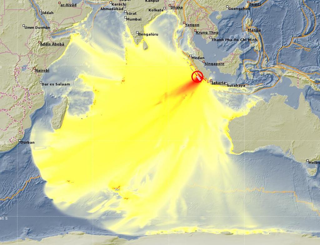
 Orange line marks trench (potential source of tsunami quakes) Travel time to the coast 20-40")
5 Challenge for local sources: Example Indonesia Short warning times (Legal mandate in Indonesia: decision 5 min after EQ origin time) Orange line marks trench (potential source of tsunami quakes) Travel time to the coast min

 in the area of peak slip (M 0 = m d A ).")
6 Sources of uncertainty in near-field tsunami assessment DART data generally not available => need to rely on seismological measurements Early seismological magnitudes underestimated for the largest earthquakes (e.g. Japan 2011) Along-strike rupture extent (which part of the coastline is inundated) => necessary for targeted warnings Along-dip rupture extent. Is the rupture focused on the shallow part of the plate interface? What are the material properties (shear modulus m) in the area of peak slip (M 0 = m d A ). Soft material (shallow fault) => larger tsunami for given M W. What is the dip of the fault plane (steeper faults => larger seafloor vertical displacement)

7

8
9
10


11 Challenge for local sources: Example Western Mediterranean Spain Tsunami potential from moderate size EQ (Zemmouri Mw 6.9 causing significant damage on Balearic islands), enhanced by steep fault North Africa Black dots: potential EQ sources Yellow dots: required spacing for achieving 15 min warning Schindelé et al. (NHESS 2008)
 Waves (Seafloor). Tilmann et al.")
12 Separation of seismic and tsunami signal Example: 16 September 2015 Illapel Earthquake, Central Chile Rayleigh Tsunami (Sea surface height) Waves (Seafloor). Tilmann et al. (2016 GRL)

13 DART July 2009, New Zealand Mw=7.6 Australian DART55015 buoy is located ca. 500 km from the epicenter (about 30 min tsunami runtime). A. Babeyko, Pers comm.
14 DART55015 July 2009, New Zealand Mw= Raw data: two sampling rates Seismic waves NOISE!!! Tsunami Depth, m min 15sek Origin time, min Detided time series. Origin time is time relative to the earthquake (09:23 UTC). 15-sec record series shows first seismic waves. Then aliased noise, Till the leading tsunami wave after ca. 30 min. A. Babeyko, Pers comm.
15 DART55015 July 2009, New Zealand Mw= Sea-surface anomaly NOISE!!! Tsunami SSH, m Origin time, min Noise amplitude from Mw=7.6 at ca. 500 km distance is comparable to the tsunami signal! A. Babeyko, Pers comm.

16 What can we do if high sampling rate recordings are available? DONET pressure recordings of Japan 2011 EQ with high sampling rate Nosov et al. (Doklady Earth Sci 2015)

17 What can we do if high sampling rate recodings are available? DONET pressure recordings of Japan 2011 EQ In raw pressure data, seismic signal dominates Low pass filtering isolates sea surface height signal (but only possible for unaliased data) Nosov et al. (Doklady Earth Sci 2015)
18 Tsunami early warning summary Focus on short term warning Repeater spacing of ~50 km should be adequate even for high stress drop sources with steep dip, which might only have a relatively small rupture zone Benefit from high sampling rate allowing separation of tsunami and seismic signal Need to ensure cable not disrupted during earthquake
19 Local earthquake monitoring


20 Chile 2010 aftershocks (land stations) Seismicity defines plate interface and crustal seismicity below land but becomes diffuse below the forearc Lange et al (GJI 2012)

21 Chile 2010 aftershocks with OBS Seismically active splay fault can be clearly identified => steeper dip potentially enhances tsunami if activated during main shock Lieser et al (Geology 2014)
: kinematic source inversion")


, R.")
22 Central Chile 2014 (Mw8.2): kinematic source inversion Reconstruction of rupture evolution requires good azimuthal coverage Detection and period measurement for earthquake early warning Tilmann et al. (GRL 2016), R. Wang, Y. Zhang (pers. Comm.)
23 Displacement from acceleration Obtain static displacement through double integration of accelerometer records (after correcting for accelerometer drift) Horizontal Red: DI-SM1 Green: DI-SM2 Blue: GPS Vertical Would be most informative on outer forearc (of course this puts cable in danger in case of major earthquake) Muzli Ph thesis (2012)
 Horizontal Red:")
 Muzli Ph thesis")
24 Displacement from acceleration Obtain static displacement through double integration of accelerometer records (after correcting for accelerometer drift) Horizontal Red: DI-SM1 Green: DI-SM2 Blue: GPS Vertical Would be most informative on outer forearc (of course this puts cable in danger in case of major earthquake) Muzli Ph thesis (2012)
25 Local earthquake Background seismicity and aftershocks Accelerometers less sensitive than seismometers but if coupling similar to land-based accelerometer, events down to magnitude 3 should be recordable across the forearc (range ~100 km) Pressure sensors provide complementary recordings of P waves if sampled at sufficiently high freq (> 20 Hz) Large earthquakes Strong motion data helps to constrain shallow slip kinematics + doubly integrated acceleration gives estimate of static offset Science targets: Frictional property variation along megathrust, splay fault activations Early warning targets: tsunami generation potential Potential to increase earthquake early warning times for megathrust earthquakes (cf existing cable networks)
26 Global earthquake monitoring


27 Global permanent station coverage +temporary Gap of station coverage in the ocean basins: South Pacific, Atlantic Only open stations accessible through IRIS or EIDA listed (esp. South America but also Africa has additional stations)
28 Example Science targets for global network Upper mantle Understand the role of different scales of convection in maintaining Understand geodynamic sources for minor volcanic activity visible in isolated seamounts (mini-hotspots; chem spots?) Deep Earth Even out coverage for mapping D (thin layer above the Earth s core), representing phase change and/or slab grave yard
29 North Atlantic OBS network Pressure and broadband seismometer s Earthquake Mw7.3 Kamchatka Dahm et al (2006)
30 Teleseismic body waves Examples based on free-fall instrumentation, expected signal levels for P wave arrivals. Rayleigh surface waves well recorded on pressure records at 15-60s s North Atlantic Tyrrhenian Sea Pressure Predicted curves for events at 70 epicentral distance (~7800 km) Acceleration Recommended noise floor in SMART accelerometer (Lentz and Phibbs, 2012) Dahm et al (BSSA 2006)
31 Local site monitoring


32 Local site monitoring - method Approach: 1. Calculate daily average cross-correlations 2. Compare codas and bring in alignement by stretching 3. Stretching factor = local %change in velocity NB: Examples are for land seismometers (not OB accelerometers) Gassenmeier et al. (GJI 2016), Richter et al. (GJI 2014)
, probably due to thermal stressing Earthquakes cause a pronounced velocity drop (softening) of up to ~2-3% for large")
, followed by exponential or quasi-logarithmic recovery Response also found for smaller earthquakes, background")
33 Local site monitoring 4-6 Hz Seasonal variations (~0.4%), probably due to thermal stressing Earthquakes cause a pronounced velocity drop (softening) of up to ~2-3% for large earthquakes (e.g. Tocopilla PGA 0.2 m/s 2 ), followed by exponential or quasi-logarithmic recovery Response also found for smaller earthquakes, background shaking, and strongly dependent on site conditions NB: Examples are for land seismometers (not OB accelerometers) Gassenmeier et al. (GJI 2016), Richter et al. (GJI 2014)
34 Local site monitoring correlation with landslides Precursory velocity drop Landslide Figure removed as paper under review and only released for oral presentation Mainsant et al (JGR, 2012): Monitoring of clayey landslide in Switzerland Velocity drop prior to landslide activation O. Marc (pers. comm.): Enhanced landslide activity after EQs in Taiwan and Japan Recovery time scale for landslide activity and vel. changes identical within error => Approach needs to be tested in marine environment
35 Data management in seismology Miniseed: Established flexible data format for acceleration and pressure time series Existing central (IRIS-DMC) and federated data centres (EIDA European Integrated Data Archive) able to serve archived and real-time data, and provide long-term safe storage. Open data preferred but protocols and technical solutions for delivering embargoed data already in place Real-time delivery through seedlink protocol Typical latency times for real-time data delivery: Sampling rate (Hz) Latency (s) ~2 => Essentially instantaneous for tsunami warning. For earthquake early warning sampling rates ~100 Hz preferred
36 Summary and siting considerations Optimise expected signal levels and information content Minimise risk of failure due to surface deformation / mass flow in major event (where applicable) No political or legal considerations taken into account Except for global earthquake need to deploy at convergent margin
37 Target Summary and siting considerations Tsunami early warning Earthquake early warning Large earthquake physics Local earthquake studies Siting 1 st preference Just seaward of trench Forearc Forearc or seaward of trench Forearc and/or seaward of trench Rationale Minimise travel time, minimise chance of coseismic failure Need to be close to likely source (seismogenic megathrust) Use strong motion both for kinematic and static inversions Observe tectonics, faults, mechanical structure Site monitoring Forearc slope Site with soft material able to generate mass failures Global EQ tomography Abyssal plain Transoceanic cables to fill gaps in global coverage Min Timing accuracy 1 min A few s 1 s 0.1 s Autocorrel: rel. timing 0.01 s, crosscorrel: abs timing 0.01 s or better 0.1 s (Body waves), 1 s (surface waves)
, Venue: Potsdam/Berlin, 2-3 day meeting Quantify with model and scenario studies the benefits for early warning and research Identify a potential target regions where a first SMART cable deployment")
38 Planned workshop SMART Cables for Earthquake and Tsunami Science and Early Warning Date TBA (November?), Venue: Potsdam/Berlin, 2-3 day meeting Quantify with model and scenario studies the benefits for early warning and research Identify a potential target regions where a first SMART cable deployment would be expected to give the most benefit Create further momentum for this initiative internationally and explore avenues of funding
Workshop on SMART Cable Applications in Earthquake and Tsunami Science and Early Warning; Potsdam, Germany, 3 4 November 2016 Short Report
 Workshop on SMART Cable Applications in Earthquake and Tsunami Science and Early Warning; Potsdam, Germany, 3 4 November 2016 Short Report Frederik Tilmann + Bruce Howe, Rhett Butler, Stuart Weinstein
Sendai Earthquake NE Japan March 11, Some explanatory slides Bob Stern, Dave Scholl, others updated March
 Sendai Earthquake NE Japan March 11, 2011 Some explanatory slides Bob Stern, Dave Scholl, others updated March 14 2011 Earth has 11 large plates and many more smaller ones. Plates are 100-200 km thick
Seismogeodesy for rapid earthquake and tsunami characterization
 Seismogeodesy for rapid earthquake and tsunami characterization Yehuda Bock Scripps Orbit and Permanent Array Center Scripps Institution of Oceanography READI & NOAA-NASA Tsunami Early Warning Projects
Section Forces Within Earth. 8 th Grade Earth & Space Science - Class Notes
 Section 19.1 - Forces Within Earth 8 th Grade Earth & Space Science - Class Notes Stress and Strain Stress - is the total force acting on crustal rocks per unit of area (cause) Strain deformation of materials
What is an Earthquake?
 Earthquakes What is an Earthquake? Earthquake - sometimes violent shaking of ground caused by movement of Earth s tectonic plates; creates seismic waves Often followed by smaller earthquakes (aftershocks);
overlie the seismogenic zone offshore Costa Rica, making the margin particularly well suited for combined land and ocean geophysical studies (Figure
 Chapter 1 Introduction Historically, highly destructive large magnitude (M w >7.0) underthrusting earthquakes nucleate along the shallow segment of subduction zone megathrust fault, and this region of
Internal Layers of the Earth
 Lecture #4 notes Geology 3950, Spring 2006; CR Stern Seismic waves, earthquake magnitudes and location, and internal earth structure (pages 28-95 in the 4 th edition and 28-32 and 50-106 in the 5 th edition)
Real time Monitoring System for Earthquakes and Tsunamis (DONET)
") Real time Monitoring System for Earthquakes and Tsunamis (DONET) NankaiTrough Yoshiyuki Kaneda Japan Agency for Marine-Earth Science and Technology (JAMSTEC) POGO@Seoul Presentation 1 Earthquakes in the
Real time Monitoring System for Earthquakes and Tsunamis (DONET) NankaiTrough Yoshiyuki Kaneda Japan Agency for Marine-Earth Science and Technology (JAMSTEC) POGO@Seoul Presentation 1 Earthquakes in the
Magnitude 7.5 NEW BRITAIN REGION, PAPUA NEW GUINEA
 A magnitude 7.5 earthquake struck off the eastern coast of Papua New Guinea on Tuesday, approximately 130 km (81 mi) southsouthwest of Kokopo at a depth of 42 km (26.1 mi). There are reports of some structural
A GLOBAL SURGE OF GREAT EARTHQUAKES FROM AND IMPLICATIONS FOR CASCADIA. Thorne Lay, University of California Santa Cruz
 A GLOBAL SURGE OF GREAT EARTHQUAKES FROM 2004-2014 AND IMPLICATIONS FOR CASCADIA Thorne Lay, University of California Santa Cruz Last 10 yrs - 18 great earthquakes: rate 1.8/yr; rate over preceding century
Tsunami Simulation of 2009 Dusky Sound Earthquake in New Zealand
 Tsunami Simulation of 2009 Dusky Sound Earthquake in New Zealand Polina Berezina 1 Institute of Geology, Taras Shevchenko National University of Kyiv, Kyiv, Ukraine Supervisor: Prof. Kenji Satake Earthquake
Moho (Mohorovicic discontinuity) - boundary between crust and mantle
 - boundary between crust and mantle") Earth Layers Dynamic Crust Unit Notes Continental crust is thicker than oceanic crust Continental Crust Thicker Less Dense Made of Granite Oceanic Crust Thinner More Dense Made of Basalt Moho (Mohorovicic
Earth Layers Dynamic Crust Unit Notes Continental crust is thicker than oceanic crust Continental Crust Thicker Less Dense Made of Granite Oceanic Crust Thinner More Dense Made of Basalt Moho (Mohorovicic
Magnitude 8.2 NORTHWEST OF IQUIQUE, CHILE
 An 8.2-magnitude earthquake struck off the coast of northern Chile, generating a local tsunami. The USGS reported the earthquake was centered 95 km (59 miles) northwest of Iquique at a depth of 20.1km
Scientific Research on the Cascadia Subduction Zone that Will Help Improve Seismic Hazard Maps, Building Codes, and Other Risk-Mitigation Measures
 Scientific Research on the Cascadia Subduction Zone that Will Help Improve Seismic Hazard Maps, Building Codes, and Other Risk-Mitigation Measures Art Frankel U.S. Geological Survey Seattle, WA GeoPrisms-Earthscope
The Earthquake of Padang, Sumatra of 30 September 2009 scientific information and update
 The Earthquake of Padang, Sumatra of 30 September 2009 scientific information and update 01-October-2009 Christophe Vigny Directeur de recherches at CNRS Laboratoire de Géologie Geoscience Dept. Of ENS,
Originally published as:
 Originally published as: Henstock, T., McNeill, L., Dean, S., Barton, P., Tilmann, F., Rietbrock, A., Robinson, D., Gulick, S., Austin, J., Djajadihardja, Y., Natawidjaja, D., Permana, H., Bonneville,
Earthquakes and Earthquake Hazards Earth - Chapter 11 Stan Hatfield Southwestern Illinois College
 Earthquakes and Earthquake Hazards Earth - Chapter 11 Stan Hatfield Southwestern Illinois College What Is an Earthquake? An earthquake is the vibration of Earth, produced by the rapid release of energy.
Earthquakes & Volcanoes
 Earthquakes & Volcanoes Geology - the study of solid Earth, the rocks of which it is composed, and the processes by which they change geo = Earth; ology = study of Earth s Layers Plate Tectonics - the
Magnitude 7.1 NEAR THE EAST COAST OF HONSHU, JAPAN
 Japan was rattled by a strong aftershock and tsunami warning Thursday night nearly a month after a devastating earthquake and tsunami flattened the northeastern coast. This earthquake can be considered
Section 19.1: Forces Within Earth Section 19.2: Seismic Waves and Earth s Interior Section 19.3: Measuring and Locating.
 CH Earthquakes Section 19.1: Forces Within Earth Section 19.2: Seismic Waves and Earth s Interior Section 19.3: Measuring and Locating Earthquakes Section 19.4: Earthquakes and Society Section 19.1 Forces
Earthquakes Chapter 19
 Earthquakes Chapter 19 Does not contain complete lecture notes. What is an earthquake An earthquake is the vibration of Earth produced by the rapid release of energy Energy released radiates in all directions
Earthquake. What is it? Can we predict it?
 Earthquake What is it? Can we predict it? What is an earthquake? Earthquake is the vibration (shaking) and/or displacement of the ground produced by the sudden release of energy. Rocks under stress accumulate
Earthquakes. Earthquake Magnitudes 10/1/2013. Environmental Geology Chapter 8 Earthquakes and Related Phenomena
 Environmental Geology Chapter 8 Earthquakes and Related Phenomena Fall 2013 Northridge 1994 Kobe 1995 Mexico City 1985 China 2008 Earthquakes Earthquake Magnitudes Earthquake Magnitudes Richter Magnitude
Tsunami and earthquake in Chile Part 2
 EUROPEAN COMMISSION DIRECTORATE GENERAL JRC JOINT RESEARCH CENTRE Institute for the Protection and Security of the Citizen Global Security and Crisis Management Unit CriTech Sunday, 28 February 2010 Executive
Earthquakes. Building Earth s Surface, Part 2. Science 330 Summer What is an earthquake?
 Earthquakes Building Earth s Surface, Part 2 Science 330 Summer 2005 What is an earthquake? An earthquake is the vibration of Earth produced by the rapid release of energy Energy released radiates in all
Earthquakes and Tsunamis
 Earthquakes and Tsunamis Kenji Satake Earthquake Research Institute University of Tokyo 1 Part I 2011 Tohoku earthquake and tsunami 2 Fukushima Dai ichi NPP accident Earthquake ground motion Reactors automatically
AIM: What are the features of Earthquakes and where are they located? Do Now: What are some words that are associated with earthquakes?
 Notepack # 11 November 8, 201 AIM: What are the features of Earthquakes and where are they located? Do Now: What are some words that are associated with earthquakes? What are Earthquakes? The shaking or
GEOLOGY MEDIA SUITE Chapter 13
 UNDERSTANDING EARTH, SIXTH EDITION GROTZINGER JORDAN GEOLOGY MEDIA SUITE Chapter 13 Earthquakes 2010 W.H. Freeman and Company Three different types of seismic waves are recorded by seismographs Key Figure
Seismic Activity near the Sunda and Andaman Trenches in the Sumatra Subduction Zone
 IJMS 2017 vol. 4 (2): 49-54 International Journal of Multidisciplinary Studies (IJMS) Volume 4, Issue 2, 2017 DOI: http://doi.org/10.4038/ijms.v4i2.22 Seismic Activity near the Sunda and Andaman Trenches
Kinematic Waveform Inversion Study of Regional Earthquakes in Southwest Iberia
 Kinematic Waveform Inversion Study of Regional Earthquakes in Southwest Iberia Ana Domingues Under supervision of Prof. João Fonseca and Dr. Susana Custódio Dep. Physics, IST, Lisbon, Portugal November
Tsunami Response and the Enhance PTWC Alerts
 Tsunami Response and the Enhance PTWC Alerts Ken Gledhill GeoNet Project Director Chair, Intergovernmental Coordination Group, Pacific Tsunami Warning and Mitigation System (PTWS) Overview 1. Procedures
Empirical Green s Function Analysis of the Wells, Nevada, Earthquake Source
 Nevada Bureau of Mines and Geology Special Publication 36 Empirical Green s Function Analysis of the Wells, Nevada, Earthquake Source by Mendoza, C. 1 and Hartzell S. 2 1 Centro de Geociencias, Universidad
JCR (2 ), JGR- (1 ) (4 ) 11, EPSL GRL BSSA
, JGR- (1 ) (4 ) 11, EPSL GRL BSSA") Dun Wang ( ) In collaboration with: Hitoshi Kawakatsu, Jim Mori, Kazuki Koketsu, Takuto Maeda, Hiroshi Tsuroka, Jiancang Zhunag, Lihua Fang, and Qiang Yao School of Geosciences, China University of Geosciences
Dun Wang ( ) In collaboration with: Hitoshi Kawakatsu, Jim Mori, Kazuki Koketsu, Takuto Maeda, Hiroshi Tsuroka, Jiancang Zhunag, Lihua Fang, and Qiang Yao School of Geosciences, China University of Geosciences
Mechanics of Earthquakes and Faulting
 Mechanics of Earthquakes and Faulting Lecture 20, 30 Nov. 2017 www.geosc.psu.edu/courses/geosc508 Seismic Spectra & Earthquake Scaling laws. Seismic Spectra & Earthquake Scaling laws. Aki, Scaling law
Earthquakes. Pt Reyes Station 1906
 Earthquakes Pt Reyes Station 1906 Earthquakes Ground shaking caused by the sudden release of accumulated strain by an abrupt shift of rock along a fracture in the earth. You Live in Earthquake Country
Indian Ocean Tsunami Warning System: Example from the 12 th September 2007 Tsunami
 Indian Ocean Tsunami Warning System: Example from the 12 th September 2007 Tsunami Charitha Pattiaratchi 1 Professor of Coastal Oceanography, The University of Western Australia Email: chari.pattiaratchi@uwa.edu.au
Our Dynamic Earth Unit Unit 5
 EARTH SCIENCE REGENTS - SOTO Our Dynamic Earth Unit Unit 5 Mr. Soto - Key 1/1/2013 Our Dynamic Earth Vocabulary List 1 Directions: Define each vocabulary word provided below. You may have to use your Earth
crustal structure experiment beneath Wairarapa - Wellington area: results from SAHKE
 crustal structure experiment beneath Wairarapa - Wellington area: results from SAHKE Tim Stern and SAHKE team* * VUW, GNS, University of Southern California, University of Tokyo(Japan) SAHKE = Seismic
Lab 1: Plate Tectonics April 2, 2009
 Name: Lab 1: Plate Tectonics April 2, 2009 Objective: Students will be introduced to the theory of plate tectonics and different styles of plate margins and interactions. Introduction The planet can be
Differentiating earthquake tsunamis from other sources; how do we tell the difference?
 Differentiating earthquake tsunamis from other sources; how do we tell the difference? David Tappin (1), Stephan Grilli (2), Jeffrey Harris (2), Timothy Masterlark (3), James Kirby (4), Fengyan Shi Shi
Magnitude 7.5 NEW BRITAIN REGION, PAPUA NEW GUINEA
 A magnitude 7.5 earthquake struck off the eastern coast of Papua New Guinea on Sunday, approximately 54 km (33 miles) southeast of Kokopo. Residents reported strong ground shaking for about five minutes.
Dense Ocean floor Network System for Earthquakes and Tsunamis DONET
 Dense Ocean floor Network System for Earthquakes and Tsunamis DONET Yoshiyuki Kaneda Japan Agency for Marine-Earth Science and Technology (JAMSTEC) ION 1 Earthquakes in the Nankai Trough Tokai Nankai Hyuga
Tsunami Physics and Preparedness. March 6, 2005 ICTP Public Information Office 1
 Tsunami Physics and Preparedness March 6, 2005 ICTP Public Information Office 1 What we do Provide world-class research facilities for scientists from developing world Foster advanced scientific research,
Magnitude 7.0 N of ANCHORAGE, ALASKA
 A magnitude 7.0 earthquake occurred just before 8:30 am local time 8 miles north of Anchorage at a depth of 40.9 km (25.4 miles). There are reports of major infrastructure damage and damage to many homes
Depth-dependent slip regime on the plate interface revealed from slow earthquake activities in the Nankai subduction zone
 2010/10/11-14 Earthscope Workshop Depth-dependent slip regime on the plate interface revealed from slow earthquake activities in the Nankai subduction zone Kazushige Obara, ERI, Univ. Tokyo Recurrence
Magnitude 7.9 SE of KODIAK, ALASKA
 A magnitude 7.9 earthquake occurred at 12:31 am local time 181 miles southeast of Kodiak at a depth of 25 km (15.5 miles). There are no immediate reports of damage or fatalities. Light shaking from this
Topic 5: The Dynamic Crust (workbook p ) Evidence that Earth s crust has shifted and changed in both the past and the present is shown by:
 Evidence that Earth s crust has shifted and changed in both the past and the present is shown by:") Topic 5: The Dynamic Crust (workbook p. 65-85) Evidence that Earth s crust has shifted and changed in both the past and the present is shown by: --sedimentary horizontal rock layers (strata) are found
Topic 5: The Dynamic Crust (workbook p. 65-85) Evidence that Earth s crust has shifted and changed in both the past and the present is shown by: --sedimentary horizontal rock layers (strata) are found
SUPPLEMENTARY INFORMATION
 doi:10.1038/nature11492 Figure S1 Short-period Seismic Energy Release Pattern Imaged by F-net. (a) Locations of broadband seismograph stations in Japanese F-net used for the 0.5-2.0 Hz P wave back-projection
Earthquakes and Faulting
 Earthquakes and Faulting Crustal Strength Profile Quakes happen in the strong, brittle layers Great San Francisco Earthquake April 18, 1906, 5:12 AM Quake lasted about 60 seconds San Francisco was devastated
Three Fs of earthquakes: forces, faults, and friction. Slow accumulation and rapid release of elastic energy.
 Earthquake Machine Stick-slip: Elastic Rebound Theory Jerky motions on faults produce EQs Three Fs of earthquakes: forces, faults, and friction. Slow accumulation and rapid release of elastic energy. Three
Earthquakes = shaking of Earth because of a rapid release of energy
 There are more than 30,000 earthquakes worldwide each year! Earthquakes = shaking of Earth because of a rapid release of energy usually because of movement of tectonic plates Most earthquakes last for
EQ Monitoring and Hazards NOTES.notebook. January 07, P-wave. S-wave. surface waves. distance
 Earthquake Monitoring and Hazards Reading a Seismogram General guidelines: P-wave First disruption of trace = Second disruption of trace = surface waves Largest disruption of trace = Not the distance to
Part 2 - Engineering Characterization of Earthquakes and Seismic Hazard. Earthquake Environment
 Part 2 - Engineering Characterization of Earthquakes and Seismic Hazard Ultimately what we want is a seismic intensity measure that will allow us to quantify effect of an earthquake on a structure. S a
UGRC 144 Science and Technology in Our Lives/Geohazards
 UGRC 144 Science and Technology in Our Lives/Geohazards Session 3 Understanding Earthquakes and Earthquake Hazards Lecturer: Dr. Patrick Asamoah Sakyi Department of Earth Science, UG Contact Information:
Magnitude 7.5 PALU, INDONESIA
 A magnitude 7.5 earthquake occurred 80.8 km (50.2 mi) north of Palu, Indonesia at a depth of 10 km (6.2 miles). This earthquake triggered a tsunami with wave heights up to 2 m (6.6 ft) that an official
Final Report for DOEI Project: Bottom Interaction in Long Range Acoustic Propagation
 Final Report for DOEI Project: Bottom Interaction in Long Range Acoustic Propagation Ralph A. Stephen Woods Hole Oceanographic Institution 360 Woods Hole Road (MS#24) Woods Hole, MA 02543 phone: (508)
Plate Tectonics IDEA THAT EARTH S SURFACE IS BROKEN INTO PLATES THAT MOVE AROUND. Fault = fracture in the crust where the movement has occurred
 Warm-up #14 A mountain range found 100 meters above sea level is measured to be 1,000 meters high from its tallest peak. From the top, the first 500 meters are incredibly steep. After this point, the mountain
Assessment Schedule 2015 Earth and Space Science: Demonstrate understanding of the causes of extreme Earth events in New Zealand (91191)
") NCEA Level 2 Earth and Space Science (91191) 2015 page 1 of 6 Assessment Schedule 2015 Earth and Space Science: Demonstrate understanding of the causes of extreme Earth events in New Zealand (91191) Evidence
NCEA Level 2 Earth and Space Science (91191) 2015 page 1 of 6 Assessment Schedule 2015 Earth and Space Science: Demonstrate understanding of the causes of extreme Earth events in New Zealand (91191) Evidence
What scientists know and do not know about the big one at Cascadia
 What scientists know and do not know about the big one at Cascadia Kelin Wang Pacific Geoscience Centre, Geological Survey of Canada Natural Resources Canada The Cascadia Subduction Zone M 7.3, 1946 Rupture
ANOTHER MEXICAN EARTHQUAKE! Magnitude 7.1, Tuesday Sept. 19, 2017
 ANOTHER MEXICAN EARTHQUAKE! Magnitude 7.1, Tuesday Sept. 19, 2017 Why is there no oceanic crust older than 200 million years? SUBDUCTION If new oceanic crust is being continuously created along the earth
Earthquakes and Earth s Interior
 - What are Earthquakes? Earthquakes and Earth s Interior - The shaking or trembling caused by the sudden release of energy - Usually associated with faulting or breaking of rocks - Continuing adjustment
Magnitude 8.3 SEA OF OKHOTSK
 A powerful earthquake in Russia's Far East was felt as far away as Moscow, about 7,000 kilometers (4,400 miles) west of the epicenter, but no casualties or damage were reported. The epicenter was in the
Advanced Workshop on Evaluating, Monitoring and Communicating Volcanic and Seismic Hazards in East Africa.
 2053-8 Advanced Workshop on Evaluating, Monitoring and Communicating Volcanic and Seismic Hazards in East Africa 17-28 August 2009 Seismicity of the East African Rift Atalay Ayele W. Addis Ababa University
Elastic rebound theory
 Elastic rebound theory Focus epicenter - wave propagation Dip-Slip Fault - Normal Normal Fault vertical motion due to tensional stress Hanging wall moves down, relative to the footwall Opal Mountain, Mojave
Deformation cycles of great subduction earthquakes in a viscoelastic Earth
 Deformation cycles of great subduction earthquakes in a viscoelastic Earth Kelin Wang Pacific Geoscience Centre, Geological Survey of Canada School of Earth and Ocean Science, University of Victoria????
Japan Agency for Marine-Earth Science and Technology (JAMSTEC), 2-15 Natsushima-cho, Yokosuka, Kanagawa, , JAPAN
, 2-15 Natsushima-cho, Yokosuka, Kanagawa, , JAPAN") LARGE EARTHQUAKE AND ASSOCIATED PHENOMENA OBSERVED WITH SEAFLOOR CABLED OBSERVATORY NEAR EPICENTER - AN IMPLICATION FOR POSSIBLE ADDITIONAL MEASUREMENT WITH TELECOMMUNICATION NETWORKS FOR IDENTIFICATION
LARGE EARTHQUAKE AND ASSOCIATED PHENOMENA OBSERVED WITH SEAFLOOR CABLED OBSERVATORY NEAR EPICENTER - AN IMPLICATION FOR POSSIBLE ADDITIONAL MEASUREMENT WITH TELECOMMUNICATION NETWORKS FOR IDENTIFICATION
Earth and Space Science Semester 2 Exam Review. Part 1. - Convection currents circulate in the Asthenosphere located in the Upper Mantle.
 Earth and Space Science 2015 Semester 2 Exam Review Part 1 Convection -A form of heat transfer. - Convection currents circulate in the Asthenosphere located in the Upper Mantle. - Source of heat is from
Real Time Monitoring System for Megathrust Earthquakes and Tsunamis - Cabled Network System and Buoy System in Japan -
 Real Time Monitoring System for Megathrust Earthquakes and Tsunamis - Cabled Network System and Buoy System in Japan - 1 Subduction zones around the world Haiti Italy Turkey Tohoku Sichuan Taiwan Sumatra
Low-Latency Earthquake Displacement Fields for Tsunami Early Warning and Rapid Response Support
 Low-Latency Earthquake Displacement Fields for Tsunami Early Warning and Rapid Response Support Hans-Peter Plag, Geoffrey Blewitt Nevada Bureau of Mines and Geology and Seismological Laboratory University
Seismic Activity and Crustal Deformation after the 2011 Off the Pacific Coast of Tohoku Earthquake
 J-RAPID Symposium March 6-7, 2013 Seismic Activity and Crustal Deformation after the 2011 Off the Pacific Coast of Tohoku Earthquake Y. Honkura Tokyo Institute of Technology Japan Science and Technology
Geophysical Journal International
 Geophysical Journal International Geophys. J. Int. (2014) 196, 1034 1042 Advance Access publication 2013 November 7 doi: 10.1093/gji/ggt434 Measuring of clock drift rates and static time offsets of ocean
5. What is an earthquake 6. Indicate the approximate radius of the earth, inner core, and outer core.
 Tutorial Problems 1. Where Do Earthquakes Happen? 2. Where do over 90% of earthquakes occur? 3. Why Do Earthquakes Happen? 4. What are the formulae for P and S velocity 5. What is an earthquake 6. Indicate
Establishment and Operation of a Regional Tsunami Warning Centre
 Establishment and Operation of a Regional Tsunami Warning Centre Dr. Charles McCreery, Director NOAA Richard H. Hagemeyer Pacific Tsunami Warning Center Ewa Beach, Hawaii USA Why A Regional Tsunami Warning
Status after Six Years
 German-Indonesian Tsunami Early Warning System () Status after Six Years Joern Lauterjung and the -Team Challenge Indonesia Short Early Warning Time Tsunamis are generated at the trench (orange line) Traveltimes
Magnitude 7.7 QUEEN CHARLOTTE ISLANDS REGION
 A major 7.7 magnitude earthquake struck at 8:04 PM local time in western British Columbia, Canada. The epicenter is located on Moresby Island, the southern large island in the Queen Charlotte Islands region.
The Earthquake Cycle Chapter :: n/a
 The Earthquake Cycle Chapter :: n/a A German seismogram of the 1906 SF EQ Image courtesy of San Francisco Public Library Stages of the Earthquake Cycle The Earthquake cycle is split into several distinct
Forces in Earth s Crust
 Name Date Class Earthquakes Section Summary Forces in Earth s Crust Guide for Reading How does stress in the crust change Earth s surface? Where are faults usually found, and why do they form? What land
Supplementary Materials for
 advances.sciencemag.org/cgi/content/full/4/3/eaao4915/dc1 Supplementary Materials for Global variations of large megathrust earthquake rupture characteristics This PDF file includes: Lingling Ye, Hiroo
Coseismic slip model
 Figure 3 - Preliminary highly smoothed model of coseismic slip for the 11 March UCL Institute for Risk & Disaster Reduction Magnitude 9.0 (JMA scale) earthquake Occurred at 02:46:23 pm local time near
I. Locations of Earthquakes. Announcements. Earthquakes Ch. 5. video Northridge, California earthquake, lecture on Chapter 5 Earthquakes!
 51-100-21 Environmental Geology Summer 2006 Tuesday & Thursday 6-9:20 p.m. Dr. Beyer Earthquakes Ch. 5 I. Locations of Earthquakes II. Earthquake Processes III. Effects of Earthquakes IV. Earthquake Risk
USU 1360 TECTONICS / PROCESSES
 USU 1360 TECTONICS / PROCESSES Observe the world map and each enlargement Pacific Northwest Tibet South America Japan 03.00.a1 South Atlantic Arabian Peninsula Observe features near the Pacific Northwest
Effect of the Emperor seamounts on trans-oceanic propagation of the 2006 Kuril Island earthquake tsunami
 GEOPHYSICAL RESEARCH LETTERS, VOL. 35, L02611, doi:10.1029/2007gl032129, 2008 Effect of the Emperor seamounts on trans-oceanic propagation of the 2006 Kuril Island earthquake tsunami S. Koshimura, 1 Y.
Geodesy (InSAR, GPS, Gravity) and Big Earthquakes
 and Big Earthquakes") Geodesy (InSAR, GPS, Gravity) and Big Earthquakes Mathew Pritchard Teh-Ru A. Song Yuri Fialko Luis Rivera Mark Simons UJNR Earthquake Research Panel, Morioka, Japan - Nov 6, 2002 Goals Accurate and high
Geodesy (InSAR, GPS, Gravity) and Big Earthquakes Mathew Pritchard Teh-Ru A. Song Yuri Fialko Luis Rivera Mark Simons UJNR Earthquake Research Panel, Morioka, Japan - Nov 6, 2002 Goals Accurate and high
LOCAL TSUNAMIS: CHALLENGES FOR PREPAREDNESS AND EARLY WARNING
 LOCAL TSUNAMIS: CHALLENGES FOR PREPAREDNESS AND EARLY WARNING HARALD SPAHN 1 1 German Technical Cooperation International Services, Jakarta, Indonesia ABSTRACT: Due to the threat of local tsunamis warning
Science Starter. Describe in your own words what an Earthquake is and what causes it. Answer The MSL
 Science Starter Describe in your own words what an Earthquake is and what causes it. Answer The MSL WHAT IS AN EARTHQUAKE AND HOW DO WE MEASURE THEM? Chapter 8, Section 8.1 & 8.2 Looking Back Deserts Wind-shaped
2. Tsunami Source Details
 2. Tsunami Source Details The Northland area faces a range of potential tsunamigenic sources that include several local and distant fault systems and underwater landslides. A NIWA study (Goff et al. 2006)
Magnitude 7.8 SCOTIA SEA
 A magnitude 7.8 earthquake has occurred in the South Orkney Island region in the Scotia Sea. According to the USGS, this earthquake is the latest in a series of moderate-tolarge earthquakes to strike this
OCN 201 Seafloor Spreading and Plate Tectonics. Question
 OCN 201 Seafloor Spreading and Plate Tectonics Question What was wrong from Wegener s theory of continental drift? A. The continents were once all connected in a single supercontinent B. The continents
Probing South Pacific mantle plumes with Broadband OBS
 Probing South Pacific mantle plumes with Broadband OBS BY D. SUETSUGU, H. SHIOBARA, H. SUGIOKA, G. BARRUOL. F. SCHINDELE, D. REYMOND, A. BONNEVILLE, E. DEBAYLE, T. ISSE, T. KANAZAWA, AND Y. FUKAO We conducted
7.1 FIJI 1, :57:22 UTC
 A magnitude 7.1 earthquake struck 141 km (88 miles) northeast of Ndoi Island, Fiji, and 313 km (194 mi) west-northwest of Nuku alofa, Tonga according to the US Geological Survey, but there were no reports
Earthquake patterns in the Flinders Ranges - Temporary network , preliminary results
 Earthquake patterns in the Flinders Ranges - Temporary network 2003-2006, preliminary results Objectives David Love 1, Phil Cummins 2, Natalie Balfour 3 1 Primary Industries and Resources South Australia
Vertical to Horizontal (V/H) Ratios for Large Megathrust Subduction Zone Earthquakes
 Ratios for Large Megathrust Subduction Zone Earthquakes") Vertical to Horizontal (V/H) Ratios for Large Megathrust Subduction Zone Earthquakes N.J. Gregor Consultant, Oakland, California, USA N.A. Abrahamson University of California, Berkeley, USA K.O. Addo BC
Vertical to Horizontal (V/H) Ratios for Large Megathrust Subduction Zone Earthquakes N.J. Gregor Consultant, Oakland, California, USA N.A. Abrahamson University of California, Berkeley, USA K.O. Addo BC
Contribution of HPC to the mitigation of natural risks. B. Feignier. CEA-DAM Ile de France Département Analyse, Surveillance, Environnement
 Contribution of HPC to the mitigation of natural risks B. Feignier CEA-DAM Ile de France Département Analyse, Surveillance, Environnement Introduction Over the last 40 years, the increase in computational
RELATION BETWEEN RAYLEIGH WAVES AND UPLIFT OF THE SEABED DUE TO SEISMIC FAULTING
 13 th World Conference on Earthquake Engineering Vancouver, B.C., Canada August 1-6, 24 Paper No. 1359 RELATION BETWEEN RAYLEIGH WAVES AND UPLIFT OF THE SEABED DUE TO SEISMIC FAULTING Shusaku INOUE 1,
Earthquakes Earth, 9th edition, Chapter 11 Key Concepts What is an earthquake? Earthquake focus and epicenter What is an earthquake?
 1 2 3 4 5 6 7 8 9 10 Earthquakes Earth, 9 th edition, Chapter 11 Key Concepts Earthquake basics. "" and locating earthquakes.. Destruction resulting from earthquakes. Predicting earthquakes. Earthquakes
Geotechnical Earthquake Engineering Prof. Deepankar Choudhury Department of Civil Engineering Indian Institute of Technology, Bombay
 Geotechnical Earthquake Engineering Prof. Deepankar Choudhury Department of Civil Engineering Indian Institute of Technology, Bombay Module - 3 Lecture - 7 Engineering Seismology (Contd ) Let us start
Megathrust Earthquakes
 Megathrust Earthquakes Susan Schwartz University of California Santa Cruz CIDER 2017 UC Berkeley July 5, 2017 The largest megathrust events are not uniformally distributed at all subduction zones. M>8
S e i s m i c W a v e s
 Project Report S e i s m i c W a v e s PORTLAND STATE UNIVERSITY PHYSICS 213 SPRING TERM 2005 Instructor: Dr. Andres La Rosa Student Name: Prisciliano Peralta-Ramirez Table Of Contents 1. Cover Sheet 2.
Earthquakes. Forces Within Eartth. Faults form when the forces acting on rock exceed the rock s strength.
 Earthquakes Vocabulary: Stress Strain Elastic Deformation Plastic Deformation Fault Seismic Wave Primary Wave Secondary Wave Focus Epicenter Define stress and strain as they apply to rocks. Distinguish
Geology 101 Study Guide #4
 Geology 101 Study Guide #4 Our last unit is the study of the earthquakes, the Earth s interior and plate tectonics. We live in a region which has been added on to North America through plate tectonics.